Bagliettoa baldensis (A. Massal.) Vězda
in Poelt & Vezda, Bibl. Lichenol., 16: 363, 1981. Basionym: Verrucaria baldensis A. Massal. - Ric. Auton. Lich. Crost.: 173, 1852.
Synonyms: Amphoridium baldense (A. Massal.) A. Massal.; Protobagliettoa exesa (Servít) Servít; Protobagliettoa kutakiana Servít; Verrucaria bagliettoaeformis (Hazsl.) ServÌt var. istriana Servít; Verrucaria dalmatica Servít; Verrucaria inaequata var. triglavensis Servít; Verrucaria parmigera f. nigroaureolata Servít; Verrucaria sphinctrina var. lojkae Servít; Verrucaria subconcentrica f. genovensis Servít
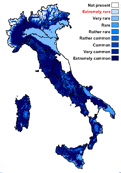
Distribution: N - VG (Tretiach 1997, Tretiach & Geletti 1997, Pinna & al. 1998, Crisafulli & al. 2006, Piervittori & al. 2006, Favero-Longo & al. 2009, 2011), Frl (Breuss 2008), Ven (Lazzarin 2000b, Nascimbene & Marini 2007, Nascimbene 2008c), TAA, Lomb, Piem (Isocrono & al. 2004), VA (Matteucci & al. 2013), Emil (Nimis & al. 1996, Fariselli & al. 2020), Lig (Giordani & al. 2016). C - Tosc, Umb (Genovesi & Ravera 2001, Ravera & al. 2006), Laz, Abr (Nimis & Tretiach 1999), Mol (Nimis & Tretiach 1999, Caporale & al. 2008, Genovesi & Ravera 2014), Sar. S - Camp (Aprile & al. 2003b, Nimis & Tretiach 2004, Garofalo & al. 2010), Pugl (Nimis & al. 1995, Nimis & Tretiach 1999), Cal (Halda 2003, Ravera & al. 2023) Si (Nimis & al. 1996b, Grillo & al. 2007, Brackel 2008b).
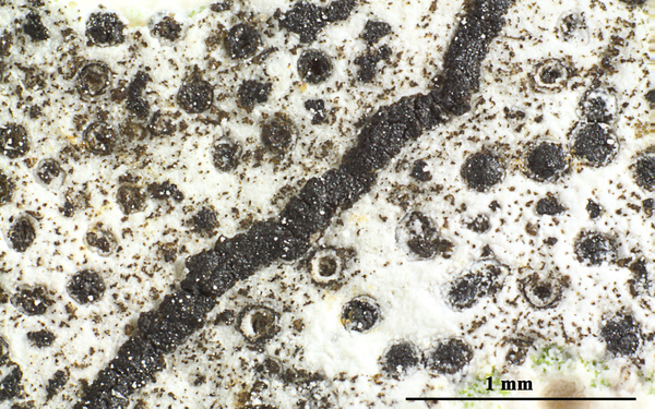
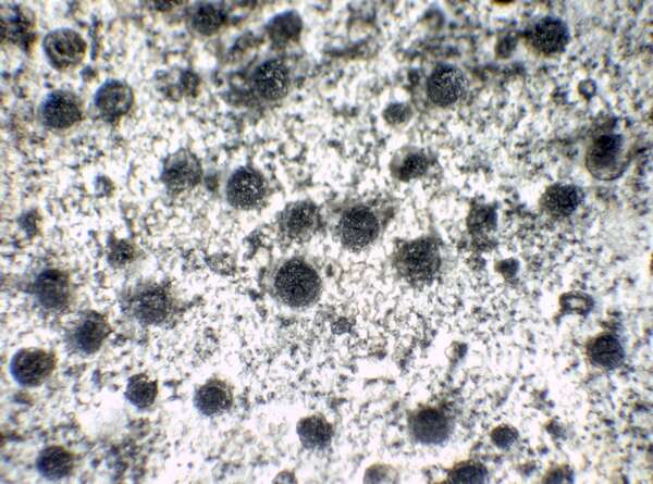
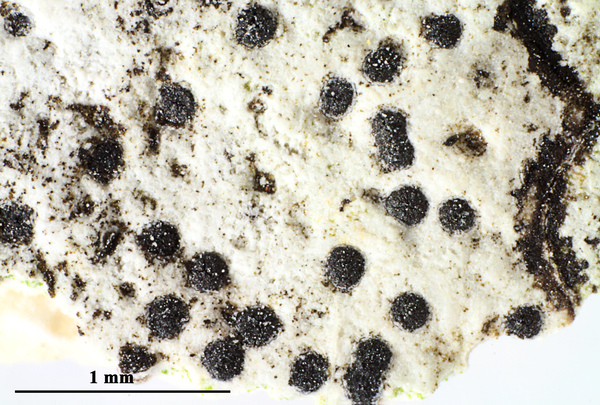
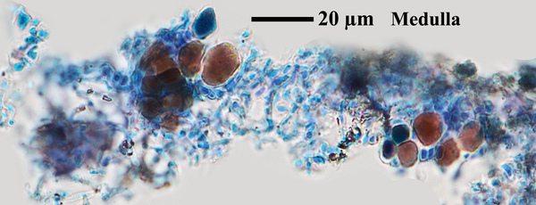
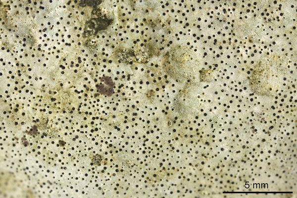
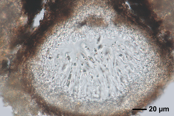
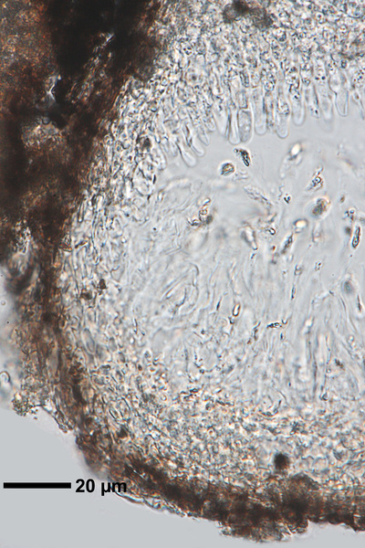
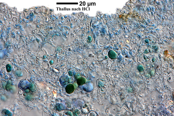
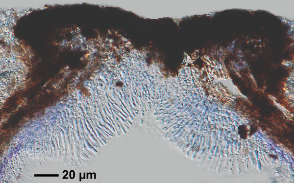
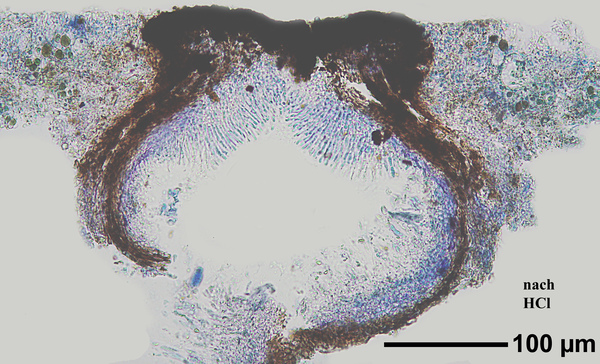
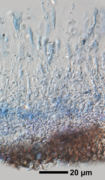
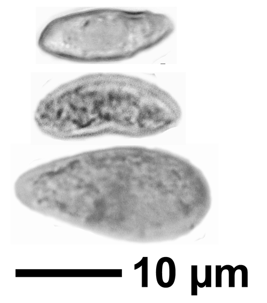
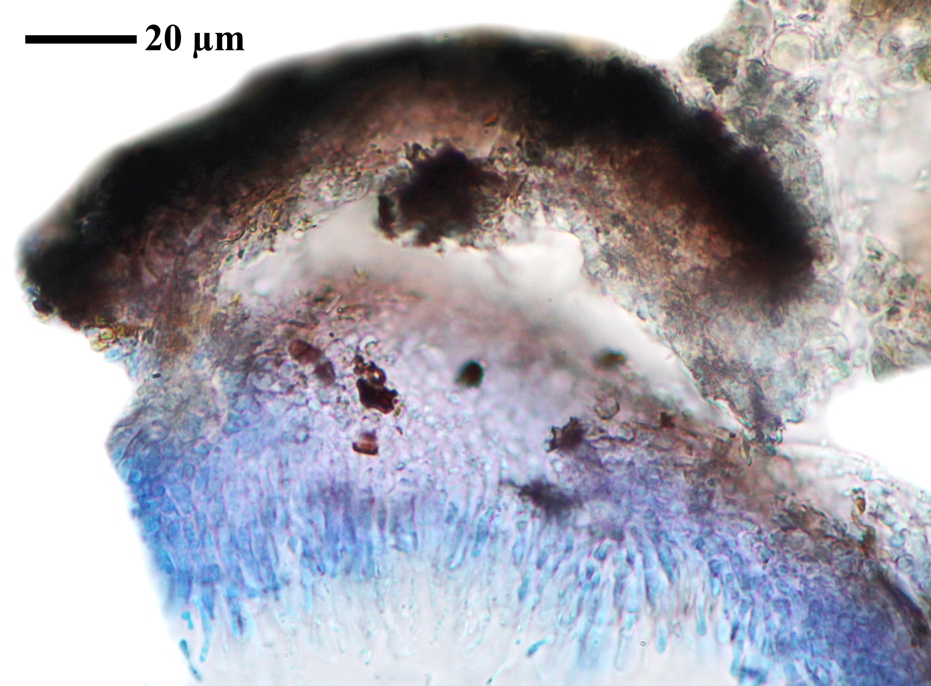
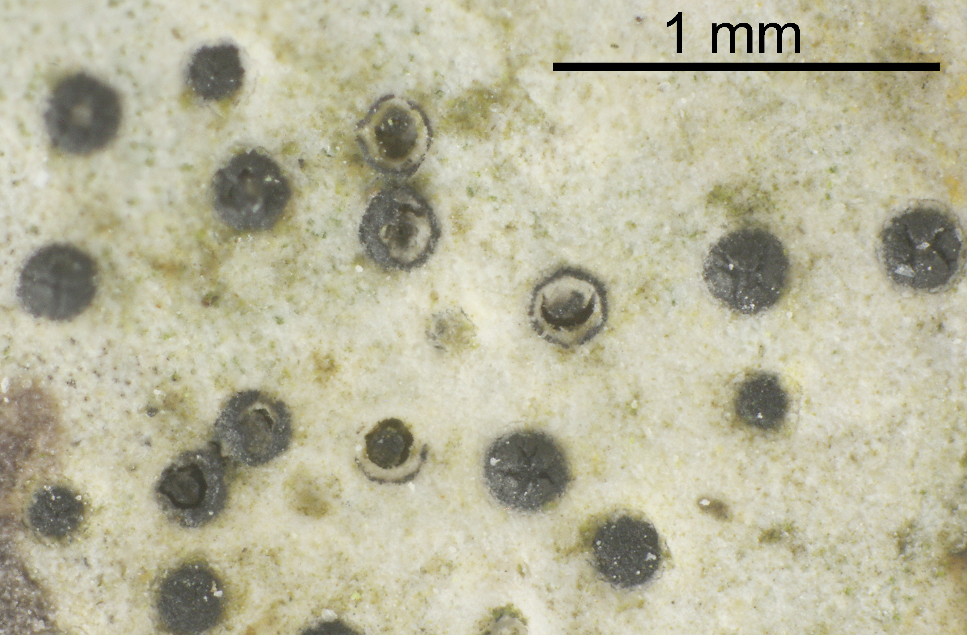
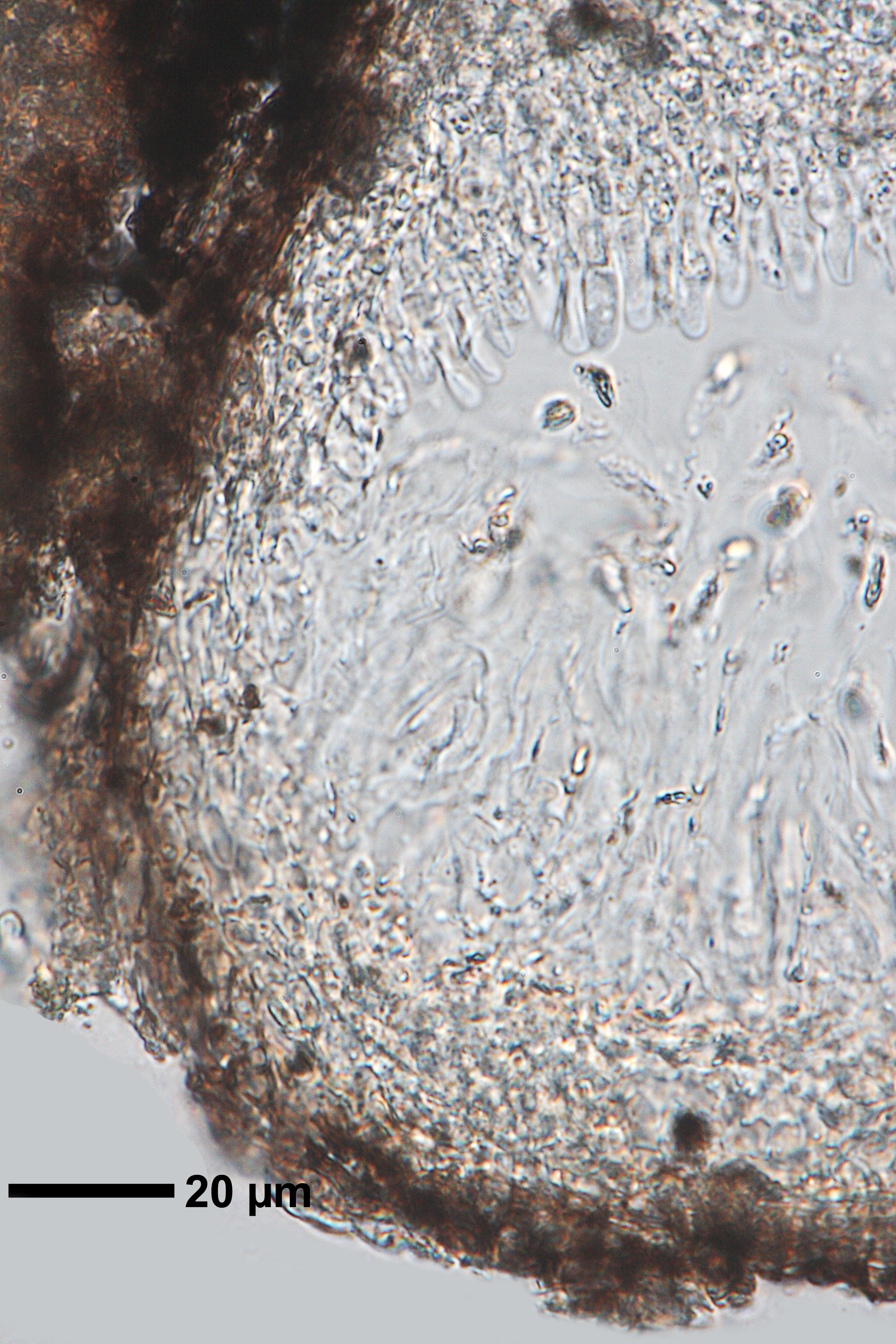
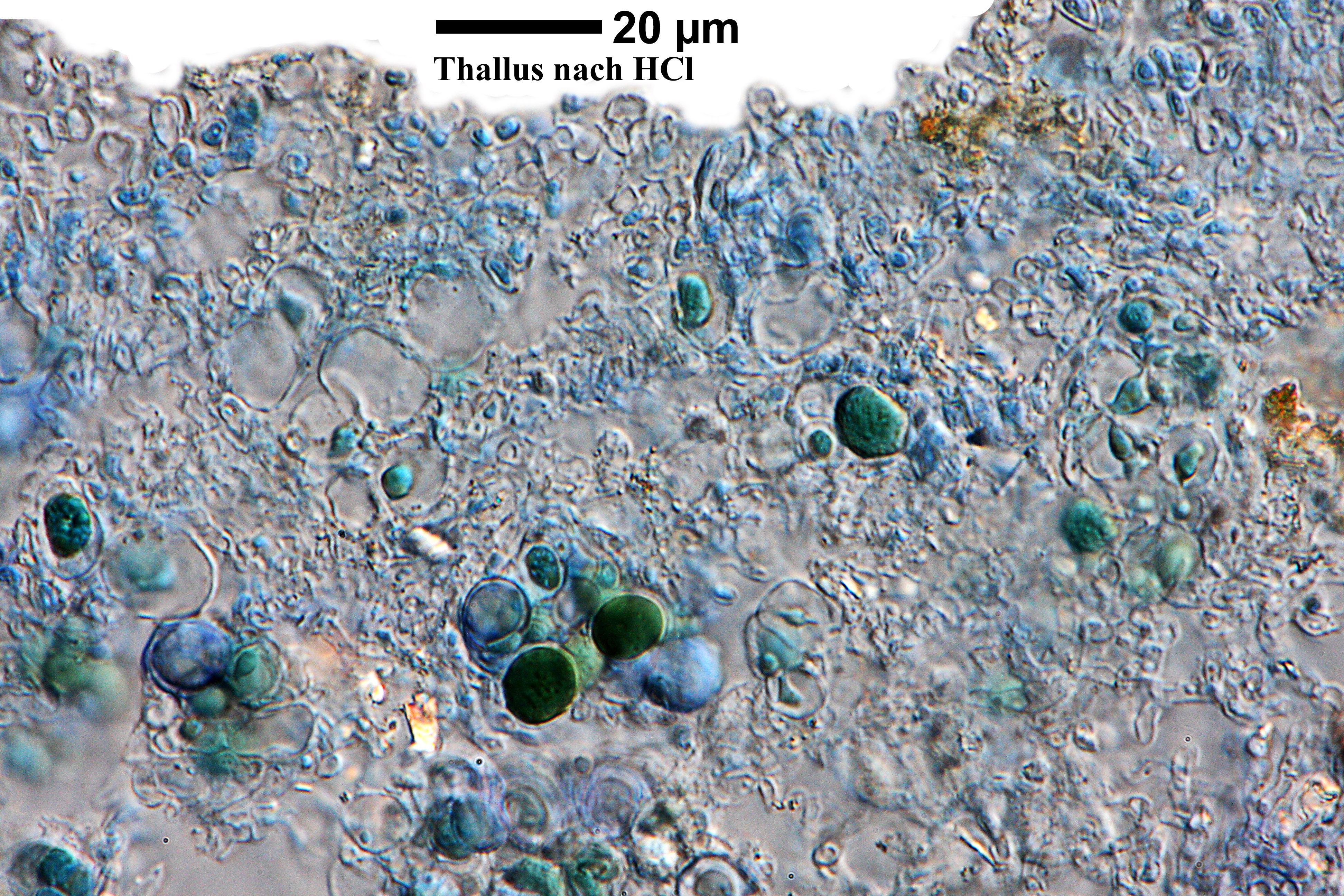
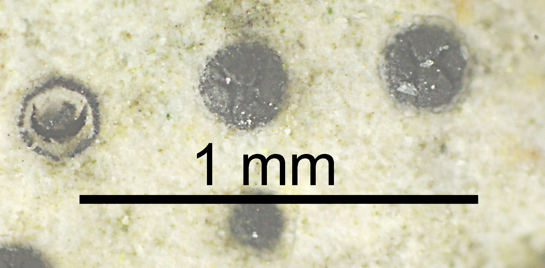
Description: Thallus crustose, fully endosubstratic, usually covering large surfaces, white to pale grey, often delimited by a dark prothalline line. Cortex (lithocortex) densely prosoplectenchymatous, of conglutinated hyphae intermingled with microcrystals; algal layer discontinuous, photobiont cells in clusters; medulla prosoplectenchymatous, sometimes with oil cells (macrosphaeroids) in the lower part. Perithecia black, flask-shaped, completely immersed in thallus and leaving deep pits in the rocks when they fall off. Involucrellum black, disc-shaped, at first whole, later with radial cracks around the ostiole, narrower than the body of the perithecium (0.2-0.3 mm wide); exciple 0.3-0.4 mm across, the wall mostly colourless, at least at the base; hymenial gel hemiamyloid, I+ red (I+ blue at very low concentrations of I), K/I+ blue; hamathecium of periphyses limited to the periostiolar region, paraphyses dissolving early. Asci 8-spored, two-layered, fissitunicate, with a thin tholus reacting I-, Verrucaria-type. Ascospores 1-celled, hyaline, ellipsoid, often poorly developed, 18-24 x 8-12 µm. Photobiont chlorococcoid. Spot tests: K-, C-, KC-, P-, UV-. Chemistry: without lichen substances. Note: a mild-temperate species of compact calcareous rocks in natural, sheltered and shaded situations, with optimum in the submediterranean belt.
Growth form: Crustose endolithic
Substrata: rocks
Photobiont: green algae other than Trentepohlia
Reproductive strategy: mainly sexual
Commonnes-rarity: (info)
Alpine belt: absent
Subalpine belt: extremely rare
Oromediterranean belt: very rare
Montane belt: rather common
Submediterranean belt: extremely common
Padanian area: very rare
Humid submediterranean belt: extremely common
Humid mediterranean belt: very common
Dry mediterranean belt: rare
Predictive model
Herbarium samples

Felix Schumm - CC BY-SA 4.0
[19684], Germany, Baden-Württemberg, Schwäbische Alb, westlich von Ochsenwang, auf Kalkfelsen im Randecker Maar, 48.57156° N, 9.52611° E, 708 m, TK 7423. Leg et det. F. Schumm, 18.08.2017.
P.L. Nimis; Owner: Department of Life Sciences, University of Trieste
Herbarium: TSB (22776)
2001/12/09
Felix Schumm - CC BY-SA 4.0
[19684], Germany, Baden-Württemberg, Schwäbische Alb, westlich von Ochsenwang, auf Kalkfelsen im Randecker Maar, 48.57156° N, 9.52611° E, 708 m, TK 7423. Leg et det. F. Schumm, 18.08.2017.

Felix Schumm - CC BY-SA 4.0
[19684], Germany, Baden-Württemberg, Schwäbische Alb, westlich von Ochsenwang, auf Kalkfelsen im Randecker Maar, 48.57156° N, 9.52611° E, 708 m, TK 7423. Leg et det. F. Schumm, 18.08.2017.
Felix Schumm - CC BY-SA 4.0
[19684], Germany, Baden-Württemberg, Schwäbische Alb, westlich von Ochsenwang, auf Kalkfelsen im Randecker Maar, 48.57156° N, 9.52611° E, 708 m, TK 7423. Leg et det. F. Schumm, 18.08.2017.
Felix Schumm - CC BY-SA 4.0
[16566], Germany, Baden-Württemberg, Kreis Göppingen, Messelstein bei Donzdorf, 48,69045° N, 9,83113° E, 750 m. An schattigem Kalkblock. Leg. et det. Schumm 26.07.2010, test. A. Aptroot 2011

Felix Schumm - CC BY-SA 4.0
[16566], Germany, Baden-Württemberg, Kreis Göppingen, Messelstein bei Donzdorf, 48,69045° N, 9,83113° E, 750 m. An schattigem Kalkblock. Leg. et det. Schumm 26.07.2010, test. A. Aptroot 2011
Felix Schumm - CC BY-SA 4.0
[16566], Germany, Baden-Württemberg, Kreis Göppingen, Messelstein bei Donzdorf, 48,69045° N, 9,83113° E, 750 m. An schattigem Kalkblock. Leg. et det. Schumm 26.07.2010, test. A. Aptroot 2011
Felix Schumm - CC BY-SA 4.0
[16566], Germany, Baden-Württemberg, Kreis Göppingen, Messelstein bei Donzdorf, 48,69045° N, 9,83113° E, 750 m. An schattigem Kalkblock. Leg. et det. Schumm 26.07.2010, test. A. Aptroot 2011
Felix Schumm - CC BY-SA 4.0
[16566], Germany, Baden-Württemberg, Kreis Göppingen, Messelstein bei Donzdorf, 48,69045° N, 9,83113° E, 750 m. An schattigem Kalkblock. Leg. et det. Schumm 26.07.2010, test. A. Aptroot 2011
Felix Schumm - CC BY-SA 4.0
[16566], Germany, Baden-Württemberg, Kreis Göppingen, Messelstein bei Donzdorf, 48,69045° N, 9,83113° E, 750 m. An schattigem Kalkblock. Leg. et det. Schumm 26.07.2010, test. A. Aptroot 2011
Felix Schumm - CC BY-SA 4.0
[16566], Germany, Baden-Württemberg, Kreis Göppingen, Messelstein bei Donzdorf, 48,69045° N, 9,83113° E, 750 m. An schattigem Kalkblock. Leg. et det. Schumm 26.07.2010, test. A. Aptroot 2011
Felix Schumm - CC BY-SA 4.0
[16566], Germany, Baden-Württemberg, Kreis Göppingen, Messelstein bei Donzdorf, 48,69045° N, 9,83113° E, 750 m. An schattigem Kalkblock. Leg. et det. Schumm 26.07.2010, test. A. Aptroot 2011

Felix Schumm - CC BY-SA 4.0
[16566], Germany, Baden-Württemberg, Kreis Göppingen, Messelstein bei Donzdorf, 48,69045° N, 9,83113° E, 750 m. An schattigem Kalkblock. Leg. et det. Schumm 26.07.2010, test. A. Aptroot 2011
Felix Schumm - CC BY-SA 4.0
[16566], Germany, Baden-Württemberg, Kreis Göppingen, Messelstein bei Donzdorf, 48,69045° N, 9,83113° E, 750 m. An schattigem Kalkblock. Leg. et det. Schumm 26.07.2010, test. A. Aptroot 2011
Growth form: Crustose endolithic
Substrata: rocks
Photobiont: green algae other than Trentepohlia
Reproductive strategy: mainly sexual
Commonnes-rarity: (info)
Alpine belt: absent
Subalpine belt: extremely rare
Oromediterranean belt: very rare
Montane belt: rather common
Submediterranean belt: extremely common
Padanian area: very rare
Humid submediterranean belt: extremely common
Humid mediterranean belt: very common
Dry mediterranean belt: rare
Predictive model
| Herbarium samples |

Felix Schumm - CC BY-SA 4.0
[19684], Germany, Baden-Württemberg, Schwäbische Alb, westlich von Ochsenwang, auf Kalkfelsen im Randecker Maar, 48.57156° N, 9.52611° E, 708 m, TK 7423. Leg et det. F. Schumm, 18.08.2017.

P.L. Nimis; Owner: Department of Life Sciences, University of Trieste
Herbarium: TSB (22776)
2001/12/09

Felix Schumm - CC BY-SA 4.0
[19684], Germany, Baden-Württemberg, Schwäbische Alb, westlich von Ochsenwang, auf Kalkfelsen im Randecker Maar, 48.57156° N, 9.52611° E, 708 m, TK 7423. Leg et det. F. Schumm, 18.08.2017.
Felix Schumm - CC BY-SA 4.0
[19684], Germany, Baden-Württemberg, Schwäbische Alb, westlich von Ochsenwang, auf Kalkfelsen im Randecker Maar, 48.57156° N, 9.52611° E, 708 m, TK 7423. Leg et det. F. Schumm, 18.08.2017.

Felix Schumm - CC BY-SA 4.0
[19684], Germany, Baden-Württemberg, Schwäbische Alb, westlich von Ochsenwang, auf Kalkfelsen im Randecker Maar, 48.57156° N, 9.52611° E, 708 m, TK 7423. Leg et det. F. Schumm, 18.08.2017.

Felix Schumm - CC BY-SA 4.0
[16566], Germany, Baden-Württemberg, Kreis Göppingen, Messelstein bei Donzdorf, 48,69045° N, 9,83113° E, 750 m. An schattigem Kalkblock. Leg. et det. Schumm 26.07.2010, test. A. Aptroot 2011
Felix Schumm - CC BY-SA 4.0
[16566], Germany, Baden-Württemberg, Kreis Göppingen, Messelstein bei Donzdorf, 48,69045° N, 9,83113° E, 750 m. An schattigem Kalkblock. Leg. et det. Schumm 26.07.2010, test. A. Aptroot 2011

Felix Schumm - CC BY-SA 4.0
[16566], Germany, Baden-Württemberg, Kreis Göppingen, Messelstein bei Donzdorf, 48,69045° N, 9,83113° E, 750 m. An schattigem Kalkblock. Leg. et det. Schumm 26.07.2010, test. A. Aptroot 2011
Felix Schumm - CC BY-SA 4.0
[16566], Germany, Baden-Württemberg, Kreis Göppingen, Messelstein bei Donzdorf, 48,69045° N, 9,83113° E, 750 m. An schattigem Kalkblock. Leg. et det. Schumm 26.07.2010, test. A. Aptroot 2011
Felix Schumm - CC BY-SA 4.0
[16566], Germany, Baden-Württemberg, Kreis Göppingen, Messelstein bei Donzdorf, 48,69045° N, 9,83113° E, 750 m. An schattigem Kalkblock. Leg. et det. Schumm 26.07.2010, test. A. Aptroot 2011

Felix Schumm - CC BY-SA 4.0
[16566], Germany, Baden-Württemberg, Kreis Göppingen, Messelstein bei Donzdorf, 48,69045° N, 9,83113° E, 750 m. An schattigem Kalkblock. Leg. et det. Schumm 26.07.2010, test. A. Aptroot 2011

Felix Schumm - CC BY-SA 4.0
[16566], Germany, Baden-Württemberg, Kreis Göppingen, Messelstein bei Donzdorf, 48,69045° N, 9,83113° E, 750 m. An schattigem Kalkblock. Leg. et det. Schumm 26.07.2010, test. A. Aptroot 2011

Felix Schumm - CC BY-SA 4.0
[16566], Germany, Baden-Württemberg, Kreis Göppingen, Messelstein bei Donzdorf, 48,69045° N, 9,83113° E, 750 m. An schattigem Kalkblock. Leg. et det. Schumm 26.07.2010, test. A. Aptroot 2011
Felix Schumm - CC BY-SA 4.0
[16566], Germany, Baden-Württemberg, Kreis Göppingen, Messelstein bei Donzdorf, 48,69045° N, 9,83113° E, 750 m. An schattigem Kalkblock. Leg. et det. Schumm 26.07.2010, test. A. Aptroot 2011