Caloplaca aegatica Giralt, Nimis & Poelt
Cryptogamie, Bryol. Lichénol., 13: 263, 1992.
Synonyms: Caloplaca quercina auct. non Flagey
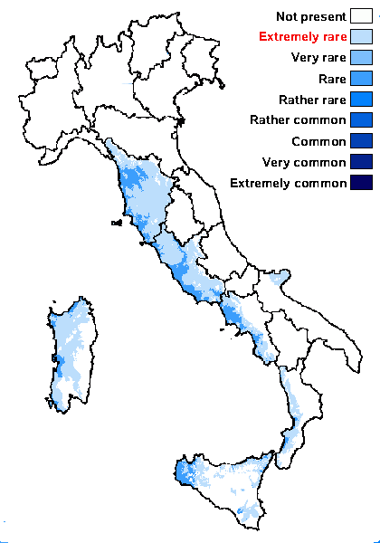
Distribution: C - Tosc (Loppi 1996b, Putortì & Loppi 1999, Benesperi & al. 2013), Marc (TSB 30959), Laz, Sar (Zedda 2002, 2002b). S - Camp (Catalano & al. 2012), Pugl (Nimis & Tretiach 1999, Durini & Medagli 2004), Cal (CLU 10869), Si (Nimis & al. 1994).
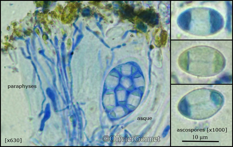
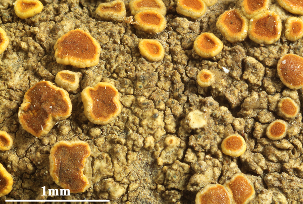
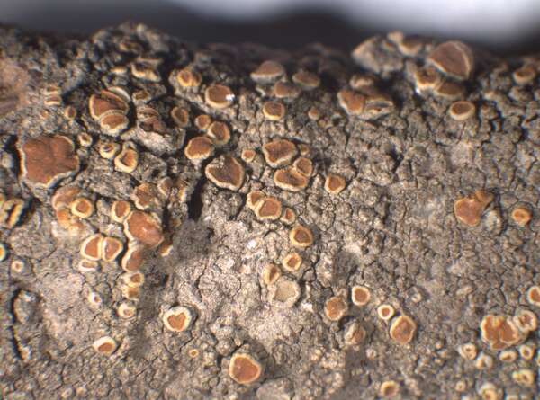
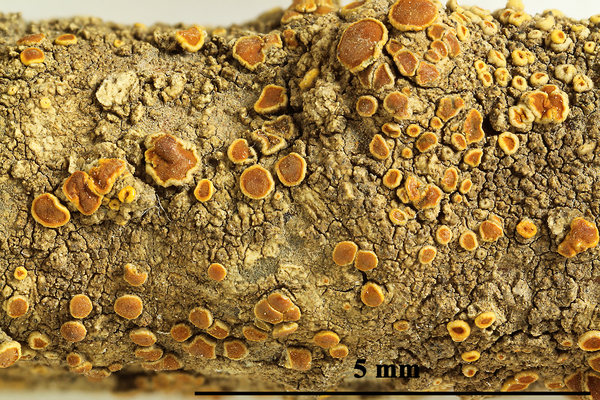
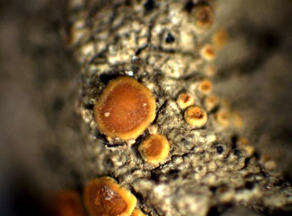
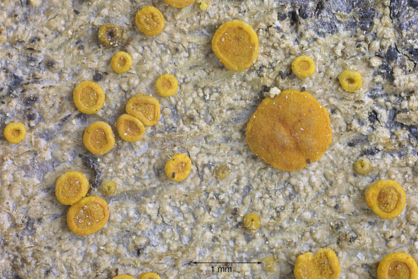
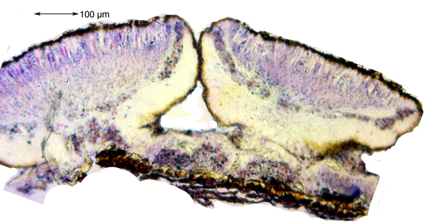
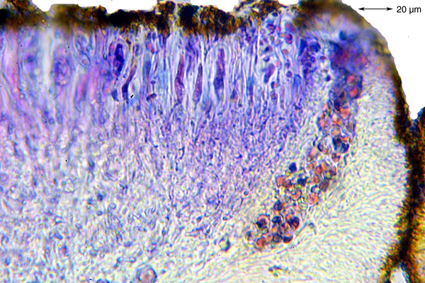
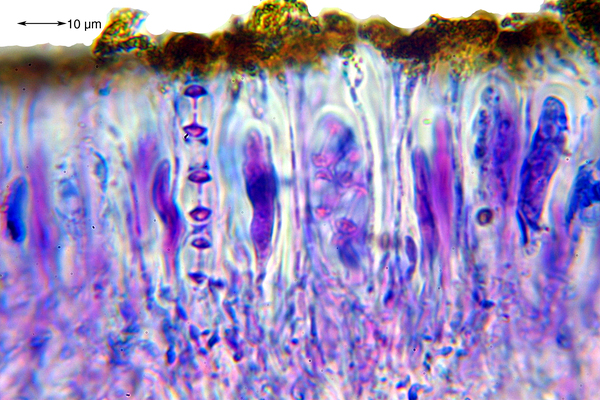
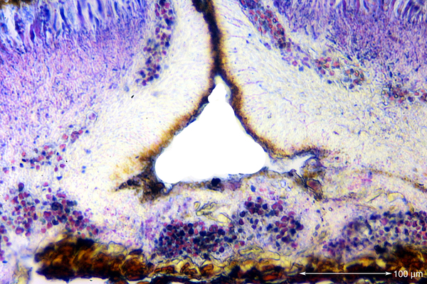
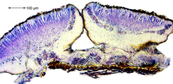
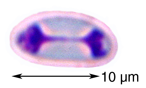
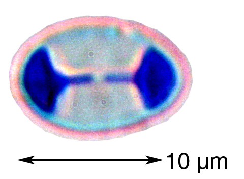
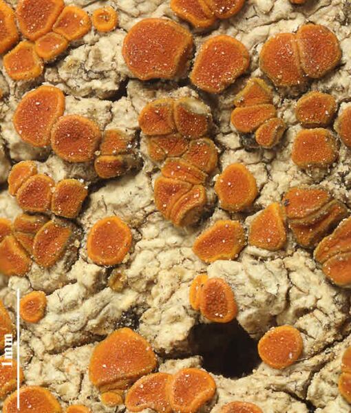
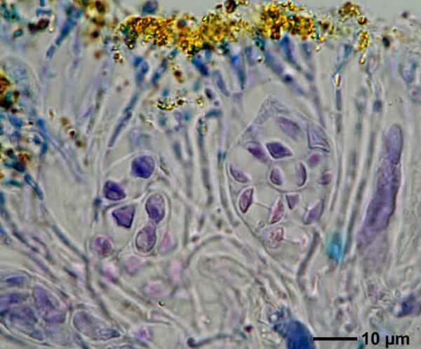
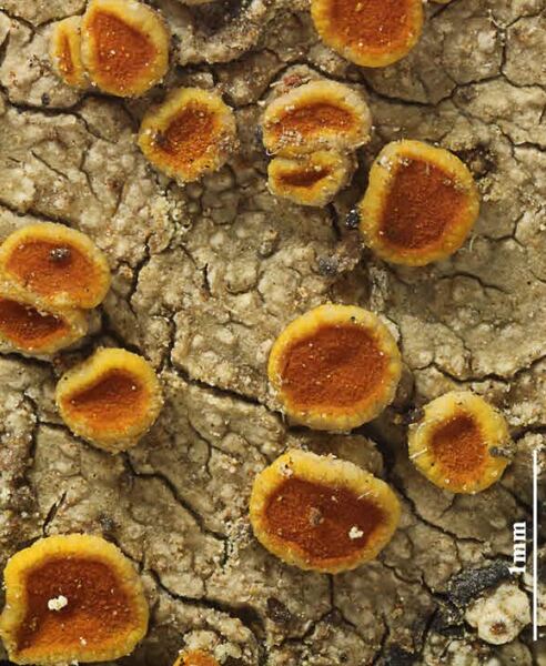
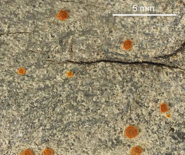
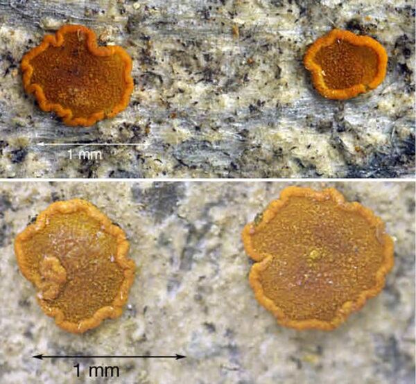
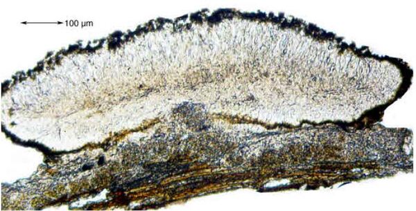
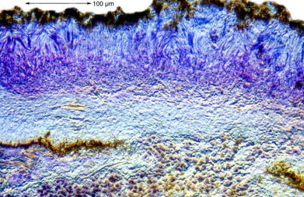
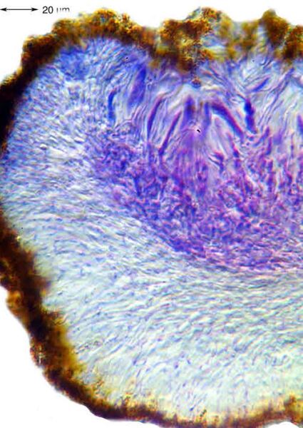
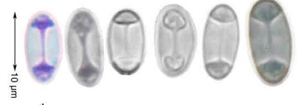
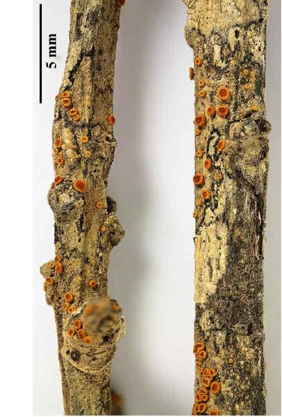
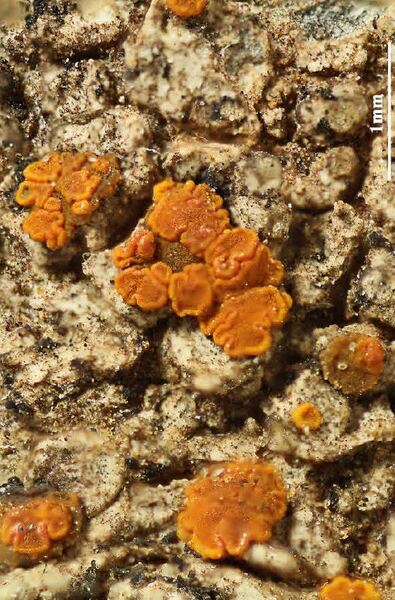
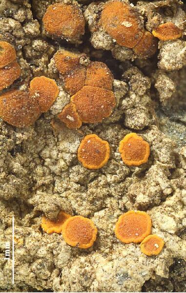
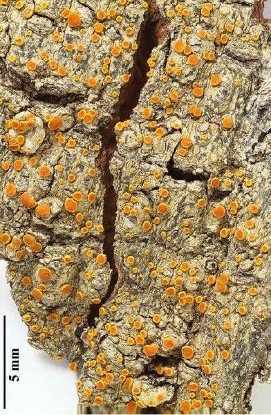
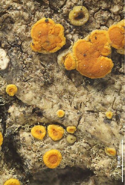
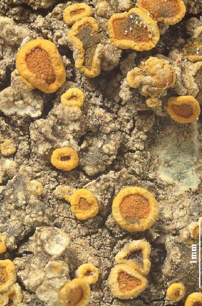
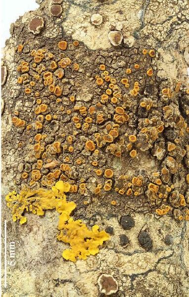
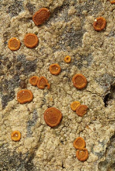
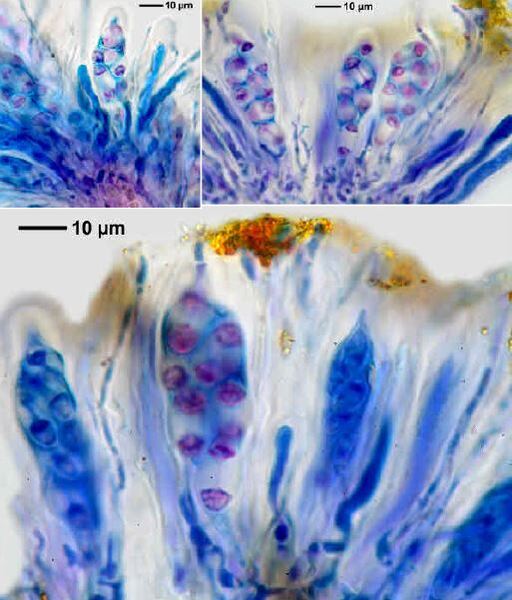
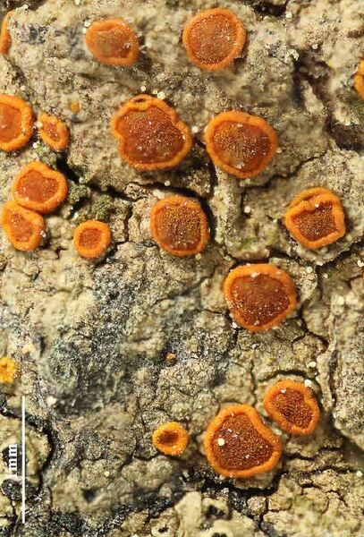
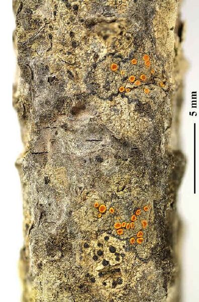
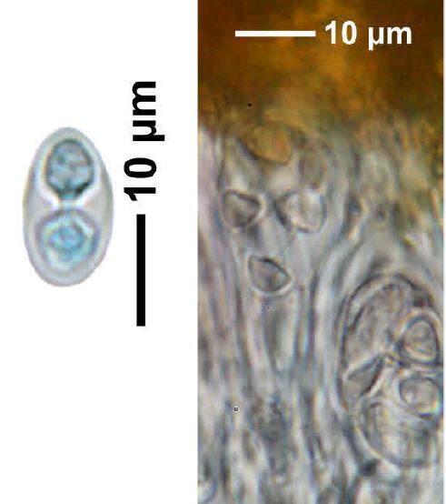
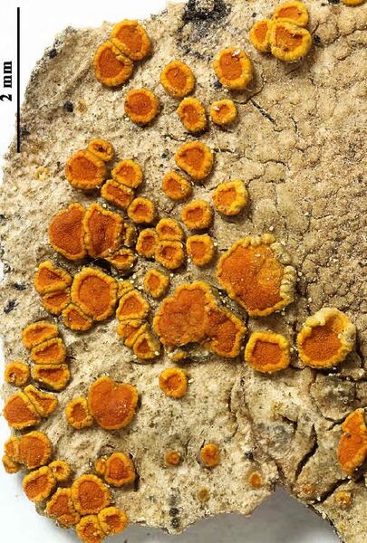
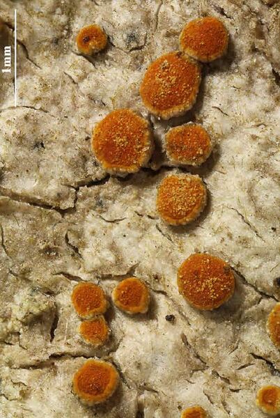
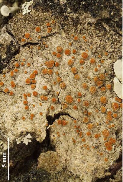
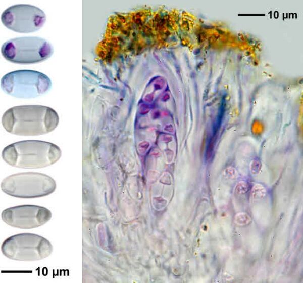
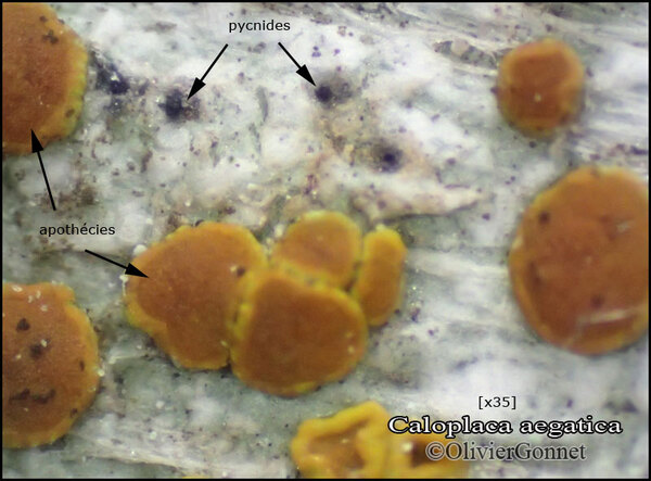
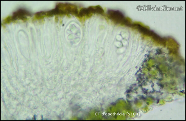
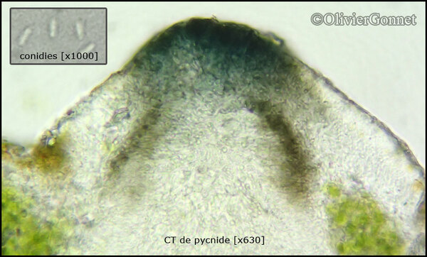
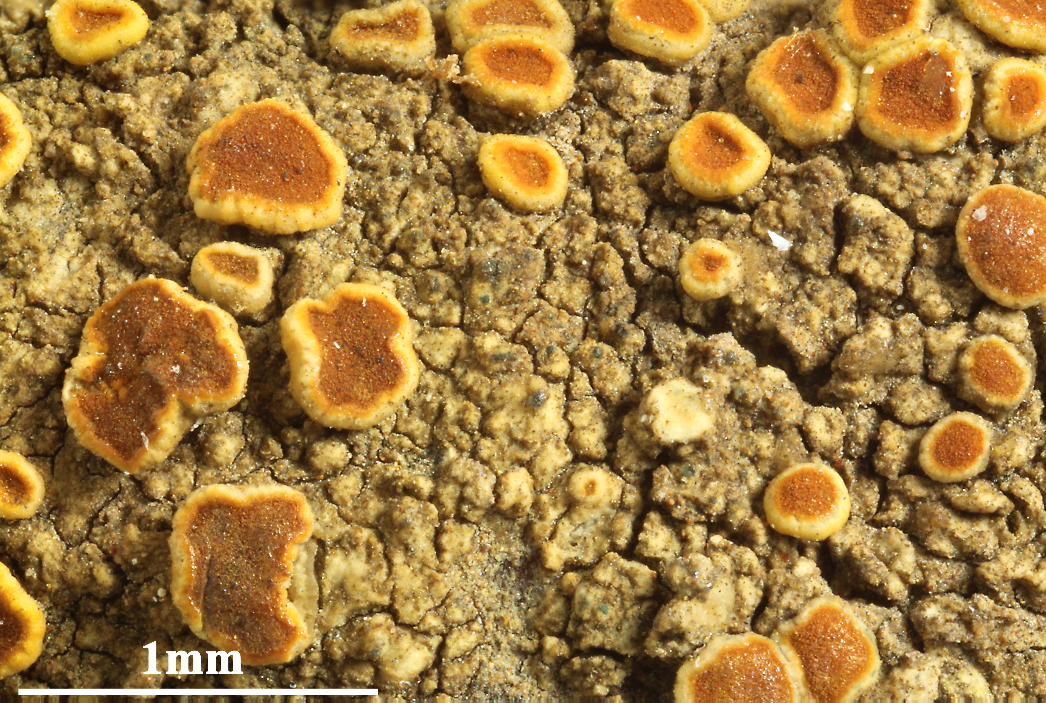
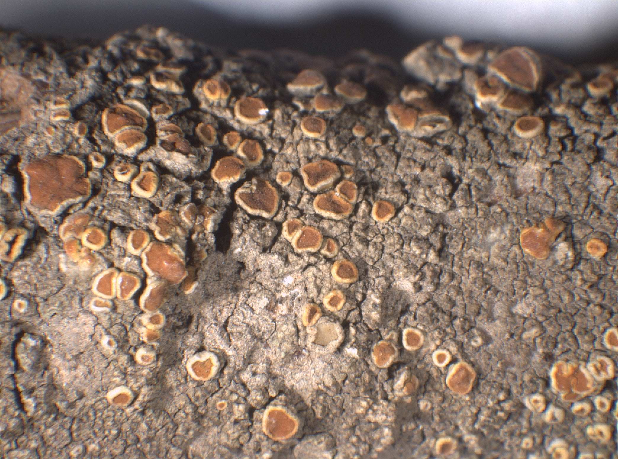
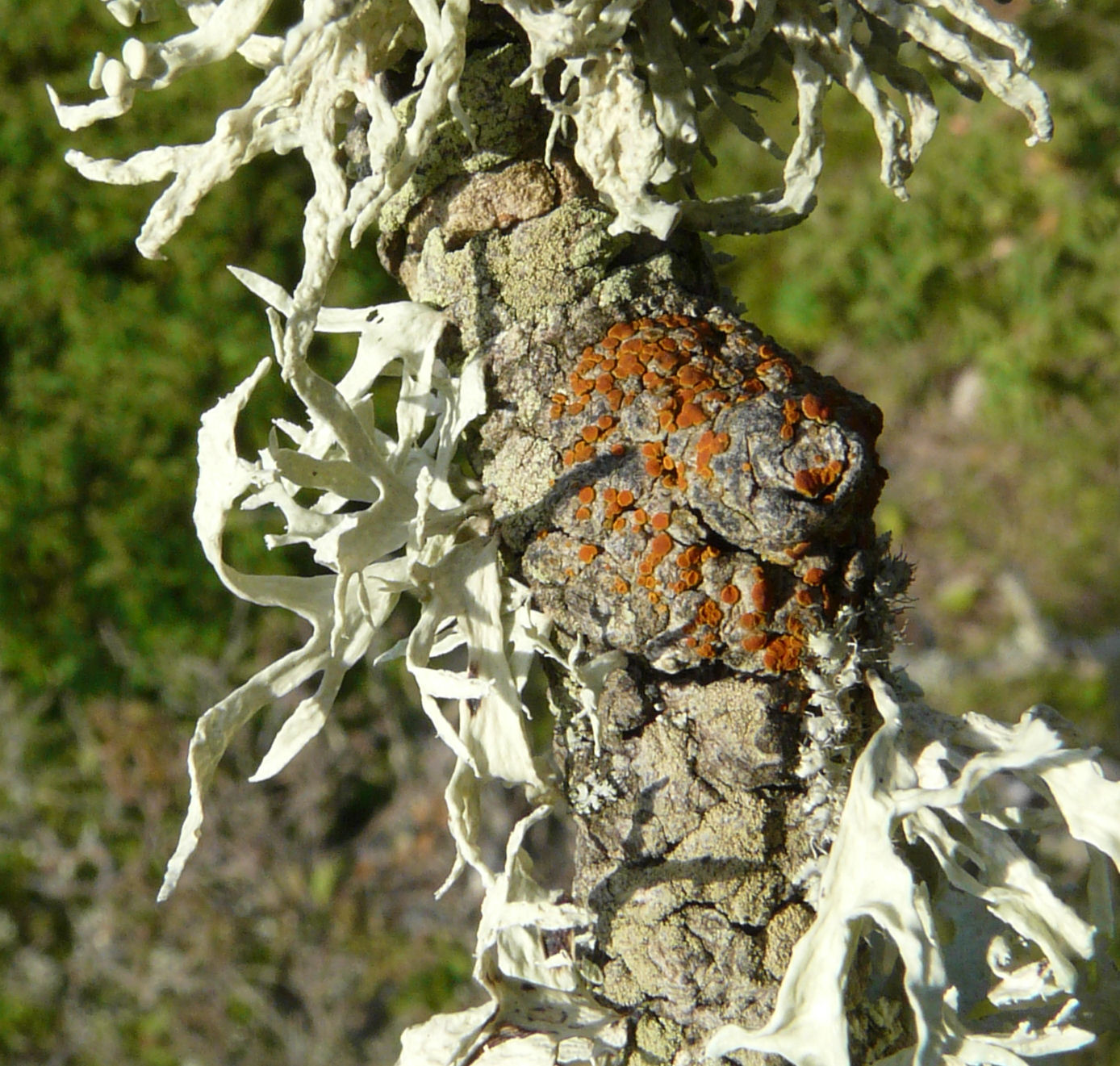
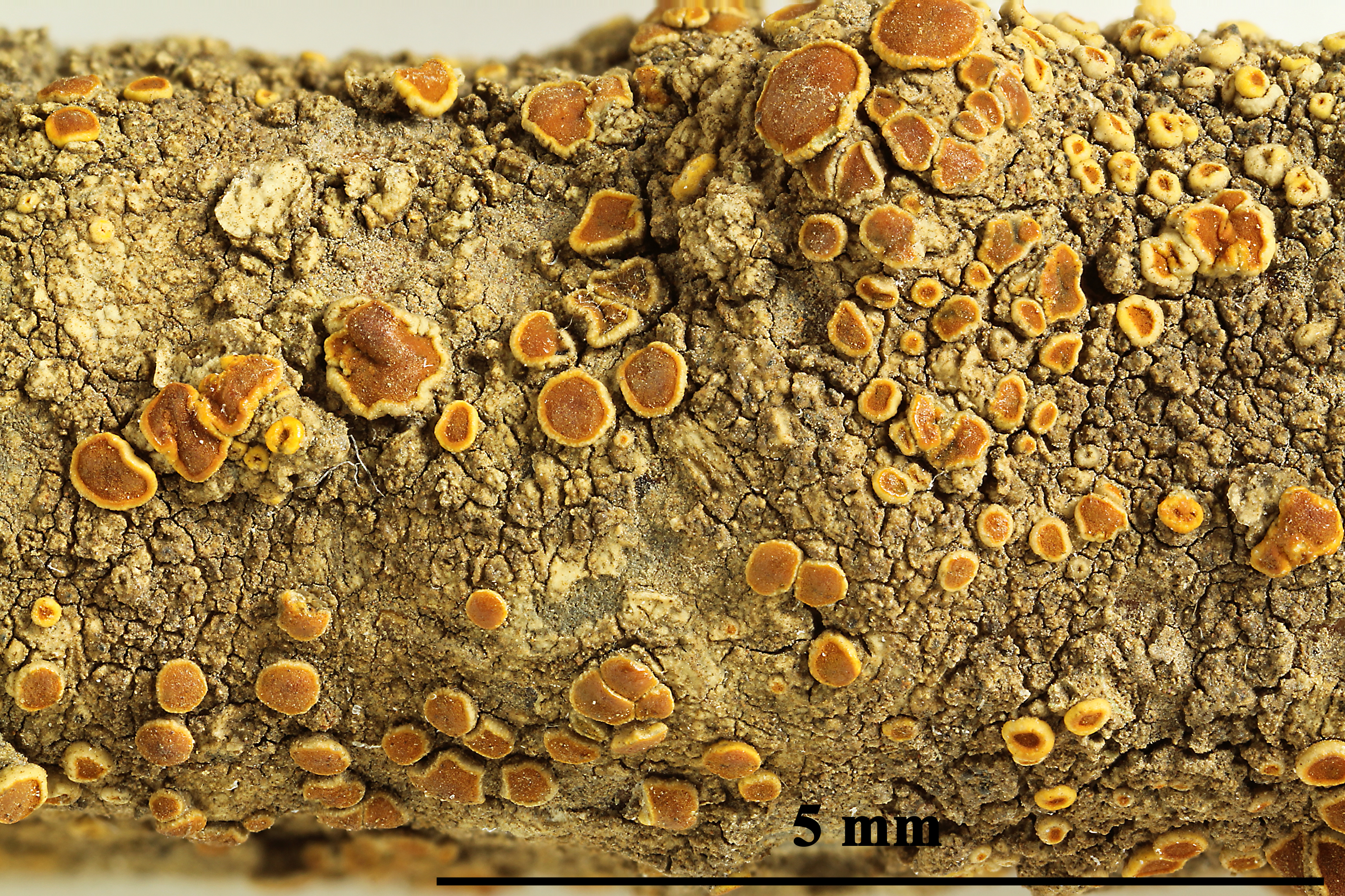
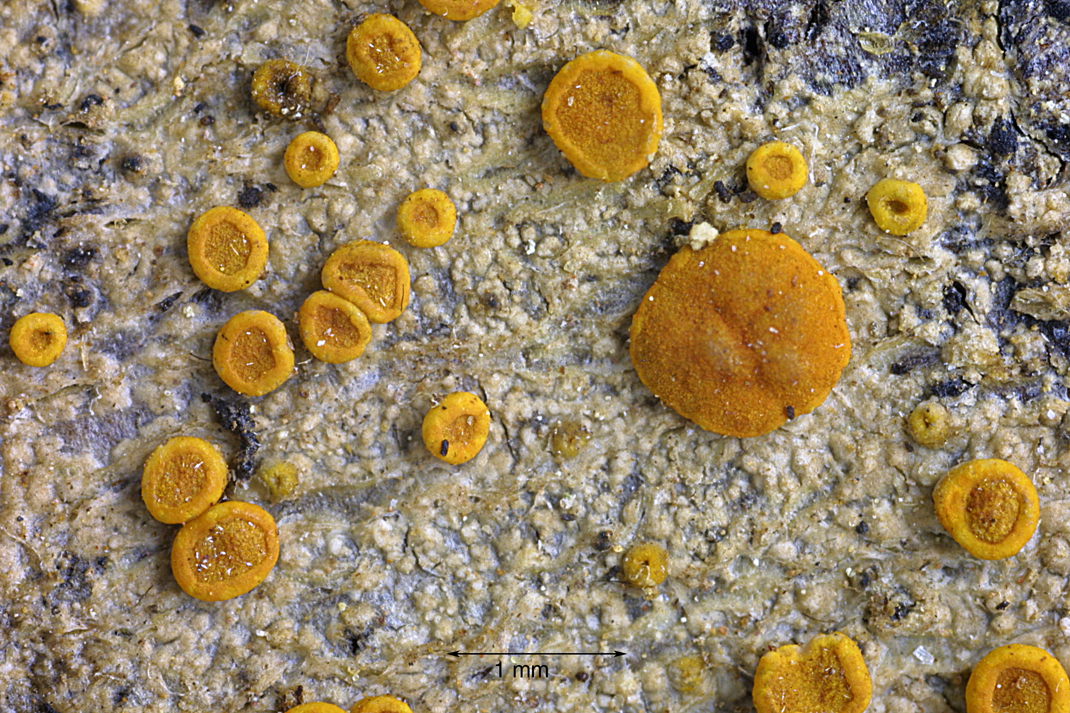
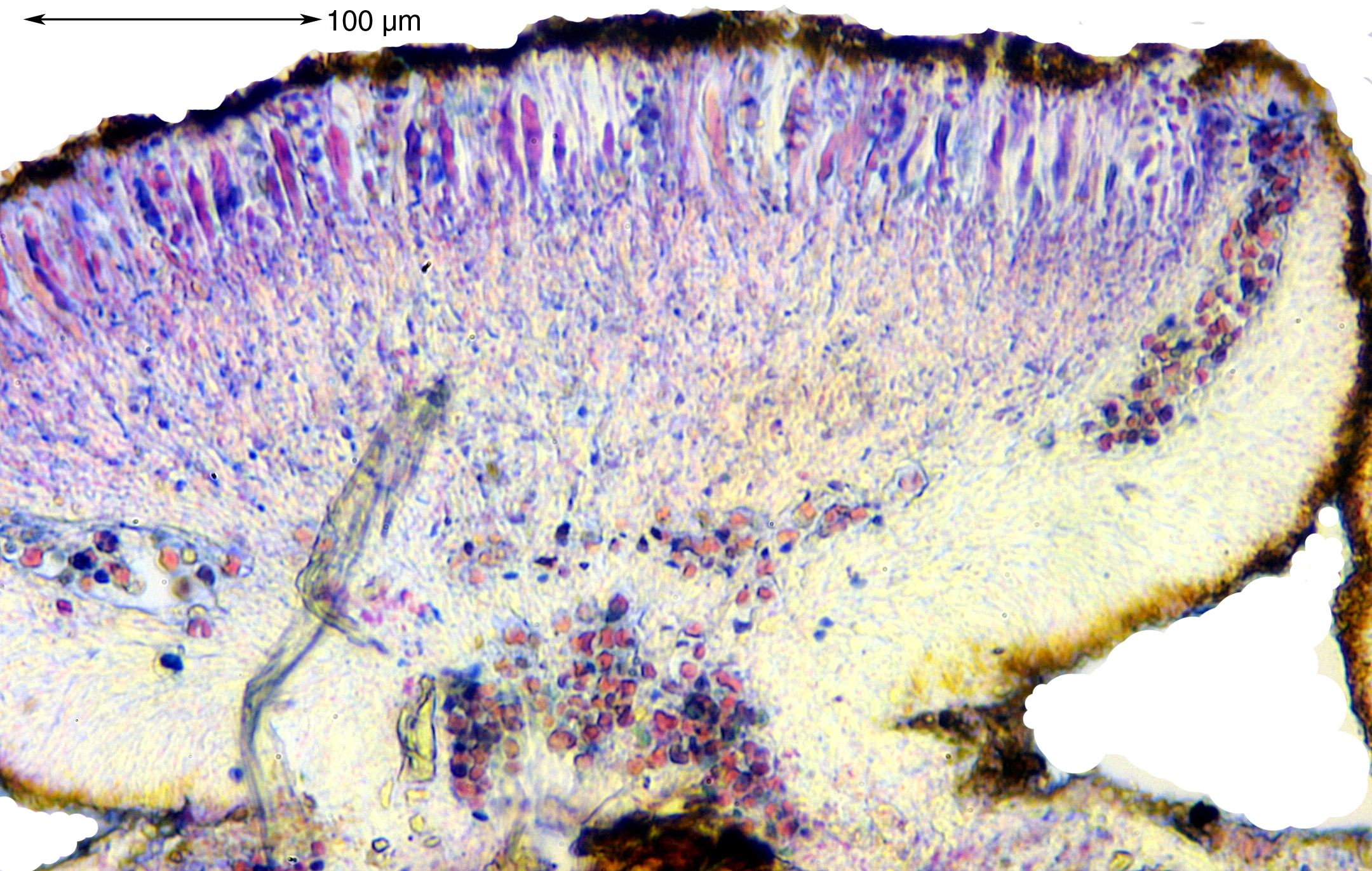
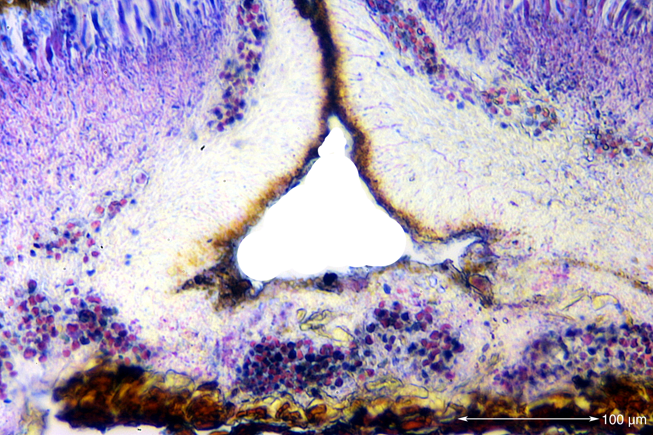
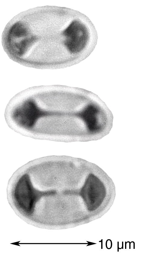
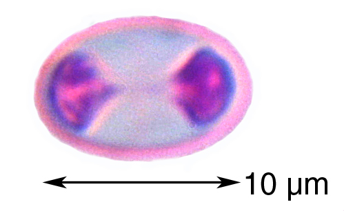
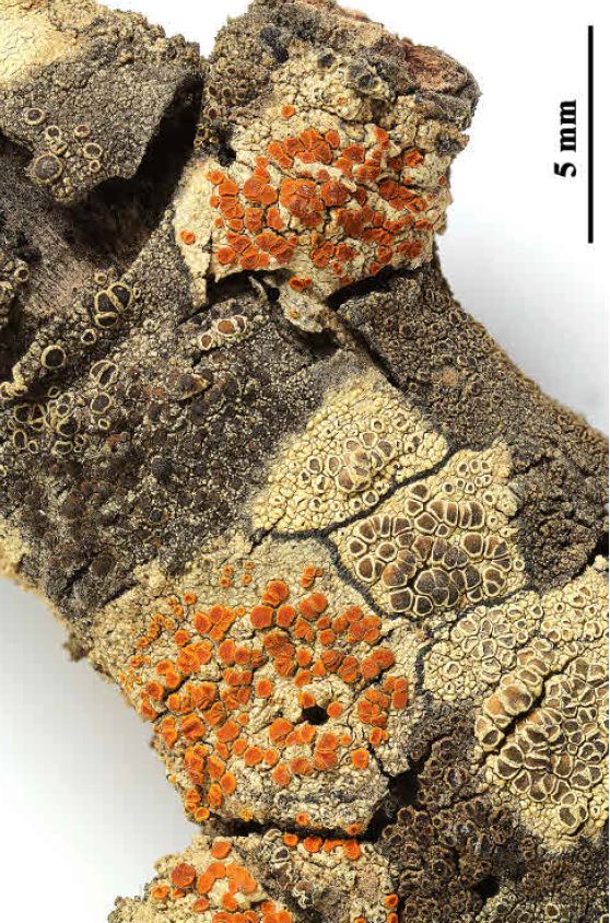
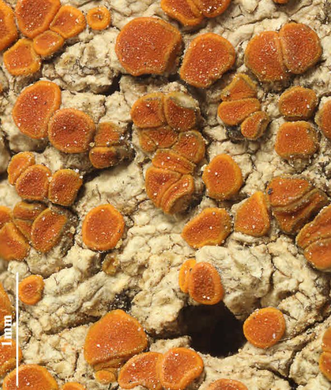
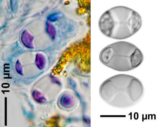
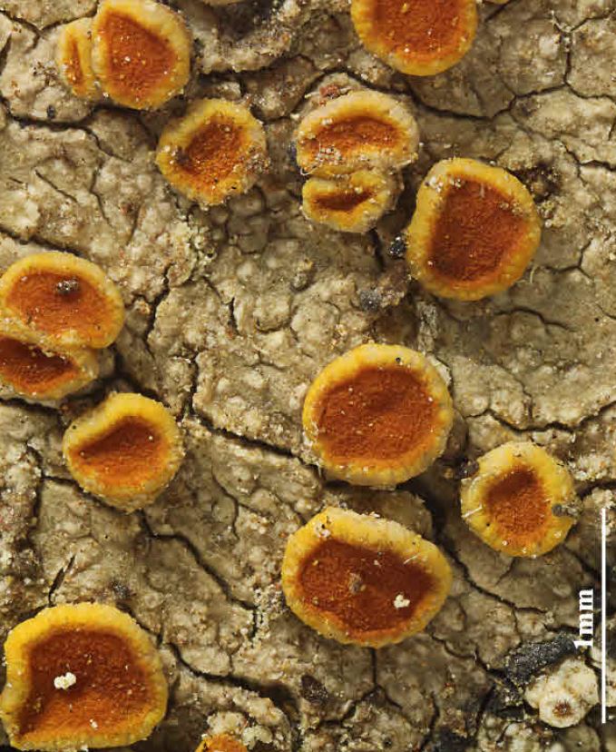
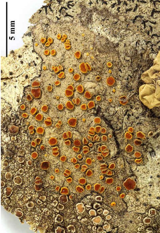
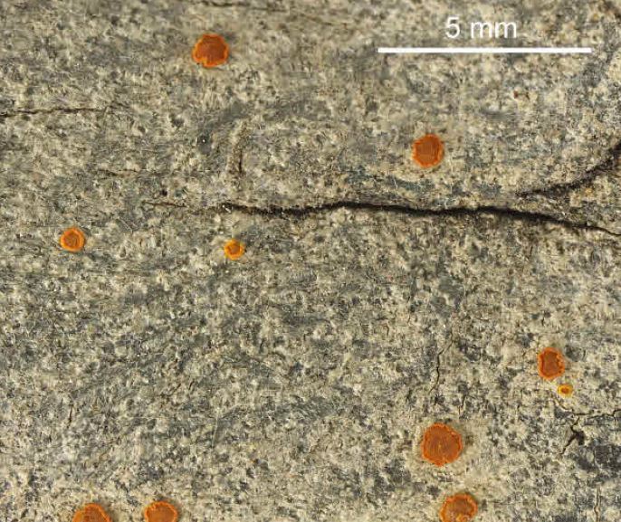
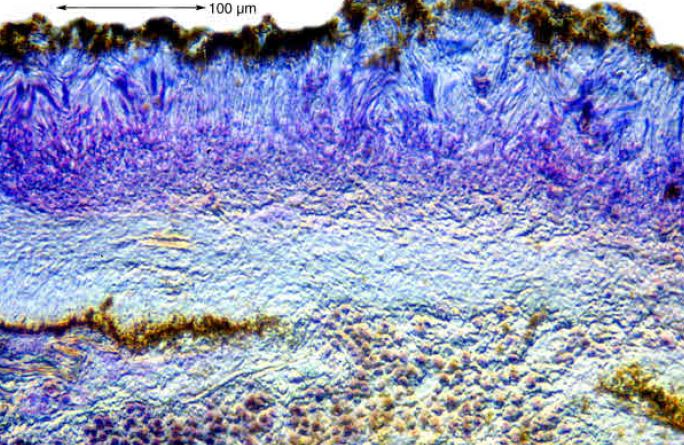
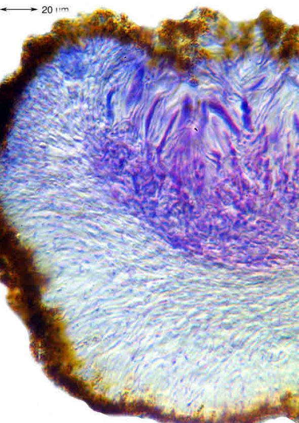
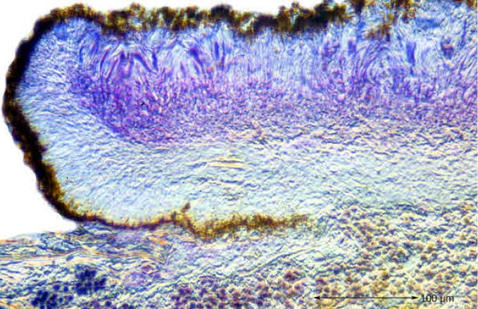
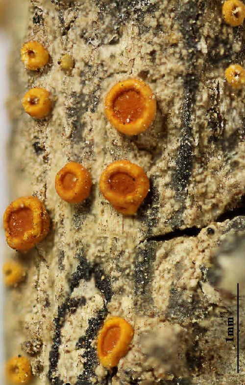
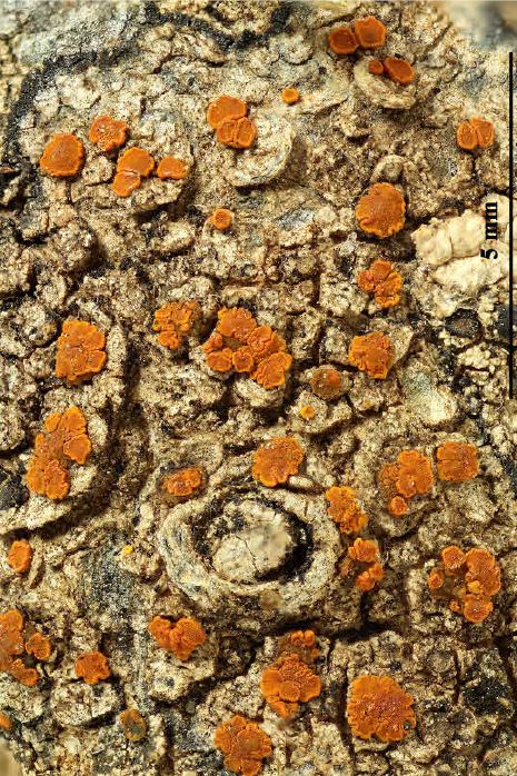
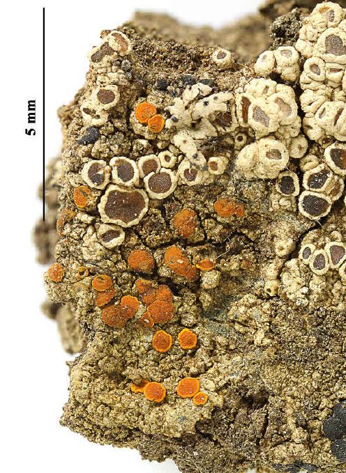
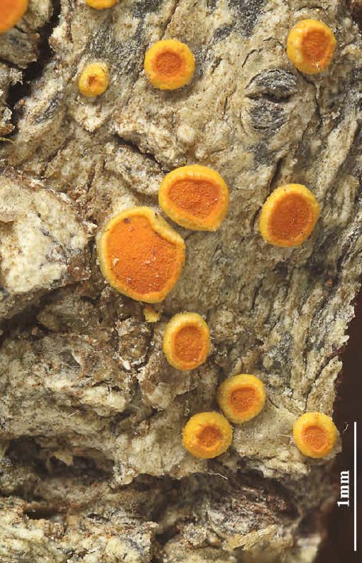
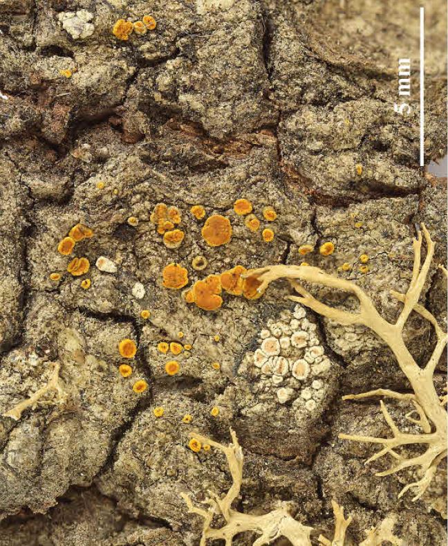
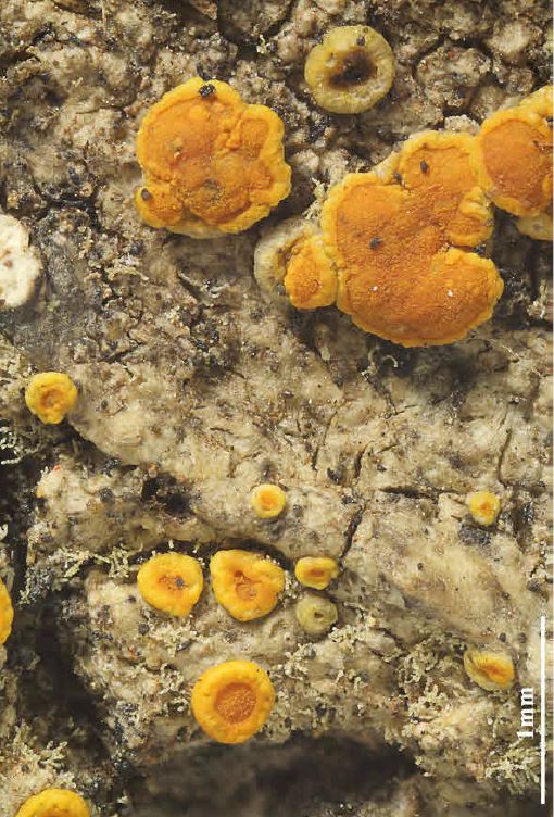
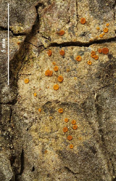
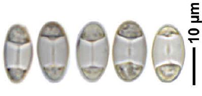
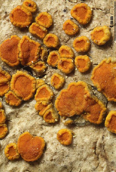
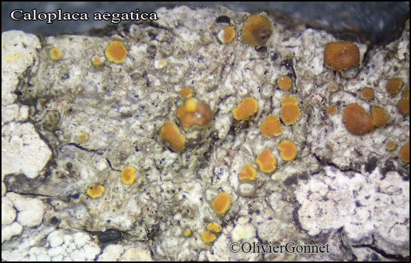
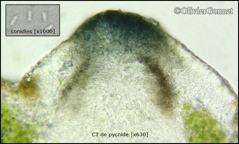
Description: Thallus crustose, often several cm wide, thinly episubstratic, grey, greenish grey or pale grey-brown, phenocorticate, without a distinct prothallus or with a black prothalline line (most evident between conspecific thalli). Apothecia zeorine, abundant, scattered or rarely clustered, round to rarely irregular in outline, 1-2 mm across, with a flat to slightly convex, orange to brownish red disc, and a thick margin composed by a thinner, but persistent, darker orange proper margin, and an initially thick, finally sometimes crenulate, rarely excluded, golden yellow thalline margin. Thalline exciple up to 100 μm thick at base, with clumps of 5-10 μm wide algal cells, clearly prosoplectenchymatous, with strongly conglutinated, thick-walled hyphae; epithecium orange-brown, K+ red, C-; hymenium colourless, not clearly separated from hypothecium, c. 80 μm high; paraphyses simple or partly forked in upper part, mostly c. 2 μm thick, some of them shorter and inspersed with oil droplets, the oil-containing cells sometimes thicker (up to 4 μm), the apical cells 3-4 μm wide; hypothecium colourless. Asci (4-)8-spored, clavate, functionally unitunicate, apically thickened with a broad internal beak, the inner part of apex and external cap I+ blue, Teloschistes-type. Ascospores 2-celled, polarilocular, hyaline, broadly ellipsoid to subglobose, 10-15 x (6-)7-9(-10) μm, the equatorial thickening (“septum”) 5-8(-10) μm. Pycnidia often numerous, slightly protruding from thallus and laterally covered with a thin thalline layer, up to 0.35 mm across, the apical part of the more or less paraplectenchymatous wall dark grey to dark blue-grey, appearing black at the naked eye. Conidia long-ellipsoid to bacilliform, 3-4 x 0.7-1.3 μm. Photobiont chlorococcoid. Spot tests: thallus K-, C-, KC-, P-; apothecia K+ red, C-. Chemistry: thallus without lichen substances; apothecia with unidentified anthraquinones.
Note: a humid subtropical to mild-temperate lichen found on trees and shrubs in open, but humid stands of Mediterranean vegetation; a typically Tyrrhenian species in Italy, mostly occurring near the coast. A possible synonymy with Ikaeria aurantiellina (Harm.) S.Y. Kondr., Upreti & Hur (Sipman & Aptroot 2020) needs further study.
Growth form: Crustose
Substrata: bark
Photobiont: green algae other than Trentepohlia
Reproductive strategy: mainly sexual
Most common in areas with a humid-warm climate (e.g. most of Tyrrenian Italy)
Taxon bound to maritime-coastal situations
Commonnes-rarity: (info)
Alpine belt: absent
Subalpine belt: absent
Oromediterranean belt: absent
Montane belt: absent
Submediterranean belt: absent
Padanian area: absent
Humid submediterranean belt: extremely rare
Humid mediterranean belt: rare
Dry mediterranean belt: absent
Predictive model
Herbarium samples

Felix Schumm; Owner: CC BY-SA 4.0
[TSB_31446], Spain, Canary Islands, Tenerife, Teno-mountains, W of Teno Alto, 28°20’35’’ N, 16°52’40’’ W, 700-750 m, on dead twigs of Chamaecytisus proliferus. Leg. et det. J. Hafellner, 16.12-1998. OBERMAYER, LICHENOTHECA GRAECENSIS FASC. 7-8, NR. 126.
P.L. Nimis; Owner: Department of Life Sciences, University of Trieste
Herbarium: TSB (31446)
2002/12/02

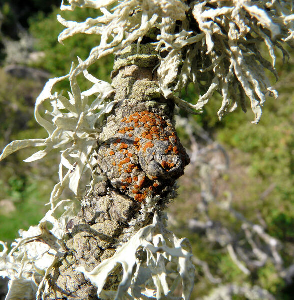
A. Moro; Owner: Department of Life Sciences, University of Trieste
Sicilia, TP, Isola di Marettimo
2008.04.03
A. Moro; Owner: Department of Life Sciences, University of Trieste
Sicilia, TP, Isola di Marettimo
2008.04.03
Felix Schumm; Owner: CC BY-SA 4.0
[TSB_31446], Spain, Canary Islands, Tenerife, Teno-mountains, W of Teno Alto, 28°20’35’’ N, 16°52’40’’ W, 700-750 m, on dead twigs of Chamaecytisus proliferus. Leg. et det. J. Hafellner, 16.12-1998. OBERMAYER, LICHENOTHECA GRAECENSIS FASC. 7-8, NR. 126.
P.L. Nimis; Owner: Department of Life Sciences, University of Trieste
Herbarium: TSB (31446)
2001/11/19
apothecia and the typical black pycnidia

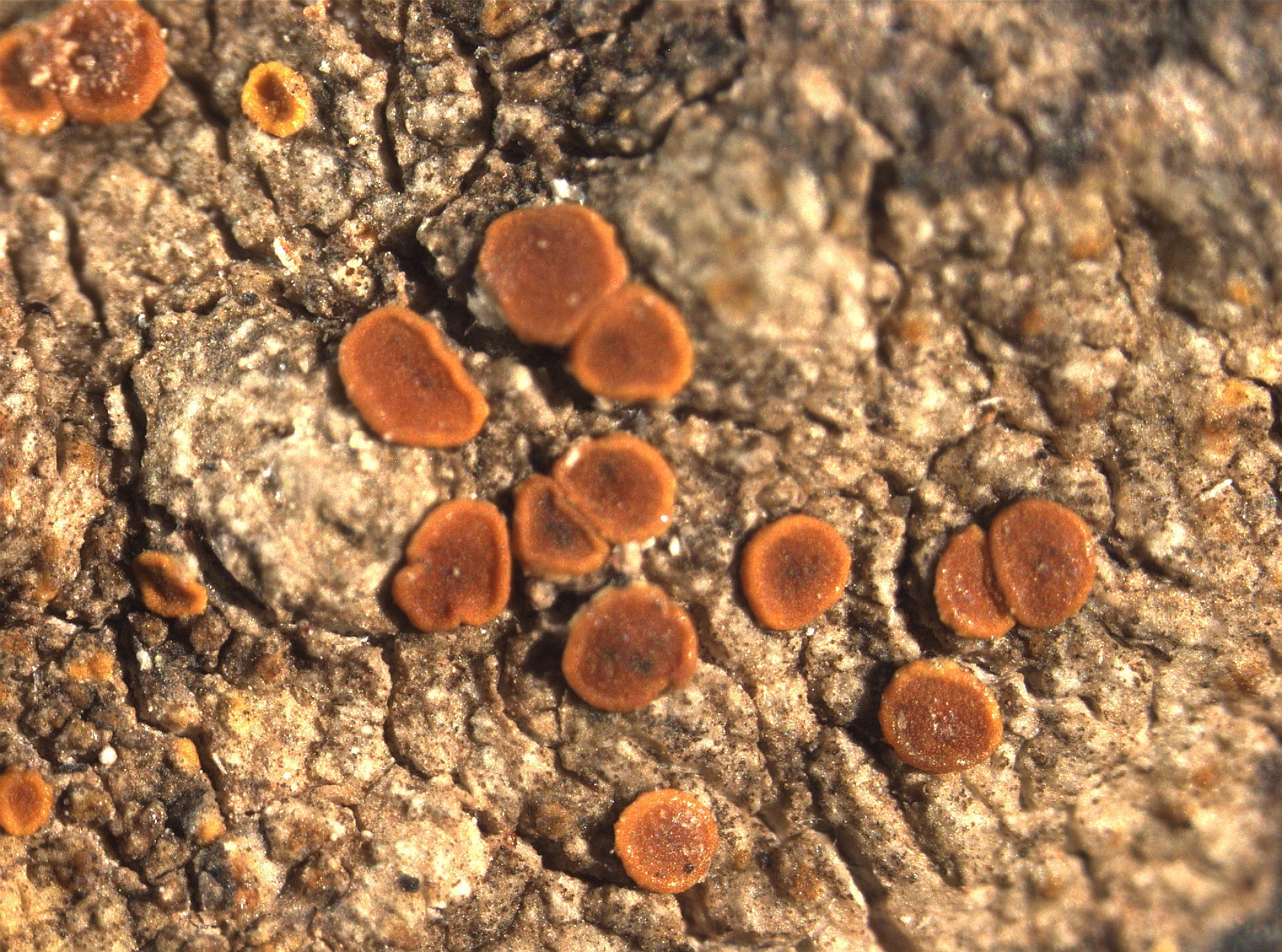
Felix Schumm – CC BY-SA 4.0
[7193], Spanien, Kanarische Inseln, Teneriffa, Teno Gebirge, Im Barranco de las Cuevas Negras, Lorbeerwaldreste, auf Laubbaum. Leg. Schumm 20.03.1978, det. Sipman 2009
Felix Schumm – CC BY-SA 4.0
[7193], Spanien, Kanarische Inseln, Teneriffa, Teno Gebirge, Im Barranco de las Cuevas Negras, Lorbeerwaldreste, auf Laubbaum. Leg. Schumm 20.03.1978, det. Sipman 2009

Felix Schumm – CC BY-SA 4.0
[7193], Spanien, Kanarische Inseln, Teneriffa, Teno Gebirge, Im Barranco de las Cuevas Negras, Lorbeerwaldreste, auf Laubbaum. Leg. Schumm 20.03.1978, det. Sipman 2009
Felix Schumm – CC BY-SA 4.0
[7193], Spanien, Kanarische Inseln, Teneriffa, Teno Gebirge, Im Barranco de las Cuevas Negras, Lorbeerwaldreste, auf Laubbaum. Leg. Schumm 20.03.1978, det. Sipman 2009

Felix Schumm – CC BY-SA 4.0
[7193], Spanien, Kanarische Inseln, Teneriffa, Teno Gebirge, Im Barranco de las Cuevas Negras, Lorbeerwaldreste, auf Laubbaum. Leg. Schumm 20.03.1978, det. Sipman 2009
Felix Schumm – CC BY-SA 4.0
[7193], Spanien, Kanarische Inseln, Teneriffa, Teno Gebirge, Im Barranco de las Cuevas Negras, Lorbeerwaldreste, auf Laubbaum. Leg. Schumm 20.03.1978, det. Sipman 2009
Felix Schumm – CC BY-SA 4.0
[7193], Spanien, Kanarische Inseln, Teneriffa, Teno Gebirge, Im Barranco de las Cuevas Negras, Lorbeerwaldreste, auf Laubbaum. Leg. Schumm 20.03.1978, det. Sipman 2009
Felix Schumm – CC BY-SA 4.0
[7193], Spanien, Kanarische Inseln, Teneriffa, Teno Gebirge, Im Barranco de las Cuevas Negras, Lorbeerwaldreste, auf Laubbaum. Leg. Schumm 20.03.1978, det. Sipman 2009
Felix Schumm – CC BY-SA 4.0
[7193], Spanien, Kanarische Inseln, Teneriffa, Teno Gebirge, Im Barranco de las Cuevas Negras, Lorbeerwaldreste, auf Laubbaum. Leg. Schumm 20.03.1978, det. Sipman 2009

Felix Schumm – CC BY-SA 4.0
[7193], Spanien, Kanarische Inseln, Teneriffa, Teno Gebirge, Im Barranco de las Cuevas Negras, Lorbeerwaldreste, auf Laubbaum. Leg. Schumm 20.03.1978, det. Sipman 2009

Felix Schumm – CC BY-SA 4.0
[7193], Spanien, Kanarische Inseln, Teneriffa, Teno Gebirge, Im Barranco de las Cuevas Negras, Lorbeerwaldreste, auf Laubbaum. Leg. Schumm 20.03.1978, det. Sipman 2009
Felix Schumm – CC BY-SA 4.0
[7193], Spanien, Kanarische Inseln, Teneriffa, Teno Gebirge, Im Barranco de las Cuevas Negras, Lorbeerwaldreste, auf Laubbaum. Leg. Schumm 20.03.1978, det. Sipman 2009
Felix Schumm – CC BY-SA 4.0
[7193], Spanien, Kanarische Inseln, Teneriffa, Teno Gebirge, Im Barranco de las Cuevas Negras, Lorbeerwaldreste, auf Laubbaum. Leg. Schumm 20.03.1978, det. Sipman 2009

Felix Schumm - CC BY-SA 4.0
[6894], Spanien, Kanarische Inseln, Gran Canaria; an der Strasse von El Tablero zum Embalse de Chira oberhalb Cercados de Espinas; nordexponierter steiler Felshang; 27°52.165’ N, 15°38.905’ W, Höhe 850 m. Leg. F. Schumm & U. Schwarz 05.01.2000, det. H. Sipmann 2016.
Felix Schumm - CC BY-SA 4.0
[6894], Spanien, Kanarische Inseln, Gran Canaria; an der Strasse von El Tablero zum Embalse de Chira oberhalb Cercados de Espinas; nordexponierter steiler Felshang; 27°52.165’ N, 15°38.905’ W, Höhe 850 m. Leg. F. Schumm & U. Schwarz 05.01.2000, det. H. Sipmann 2016.
Felix Schumm - CC BY-SA 4.0
[6894], Spanien, Kanarische Inseln, Gran Canaria; an der Strasse von El Tablero zum Embalse de Chira oberhalb Cercados de Espinas; nordexponierter steiler Felshang; 27°52.165’ N, 15°38.905’ W, Höhe 850 m. Leg. F. Schumm & U. Schwarz 05.01.2000, det. H. Sipmann 2016.

Felix Schumm - CC BY-SA 4.0
[6894], Spanien, Kanarische Inseln, Gran Canaria; an der Strasse von El Tablero zum Embalse de Chira oberhalb Cercados de Espinas; nordexponierter steiler Felshang; 27°52.165’ N, 15°38.905’ W, Höhe 850 m. Leg. F. Schumm & U. Schwarz 05.01.2000, det. H. Sipmann 2016.
Felix Schumm - CC BY-SA 4.0
[5429], Spanien, Gran Canaria, Barranco de Los Tilos südlich Moya, 28°04.766’ N, 15°35.935’ W, Höhe 620 m. Leg. F. Schumm & U. Schwarz 28.12.1998, det. A. Aptroot 2016.

Felix Schumm - CC BY-SA 4.0
[5429], Spanien, Gran Canaria, Barranco de Los Tilos südlich Moya, 28°04.766’ N, 15°35.935’ W, Höhe 620 m. Leg. F. Schumm & U. Schwarz 28.12.1998, det. A. Aptroot 2016.
Felix Schumm - CC BY-SA 4.0
[8634], Portugal, Madeira, an der Straße bei Portela, 32°44,812’ N, W 16°49,623’ W, 575 m, an Zeder. Leg. et det. Schumm 15.04.2001,
Felix Schumm - CC BY-SA 4.0
[8634], Portugal, Madeira, an der Straße bei Portela, 32°44,812’ N, W 16°49,623’ W, 575 m, an Zeder. Leg. et det. Schumm 15.04.2001,
Felix Schumm - CC BY-SA 4.0
[8634], Portugal, Madeira, an der Straße bei Portela, 32°44,812’ N, W 16°49,623’ W, 575 m, an Zeder. Leg. et det. Schumm 15.04.2001,
Felix Schumm - CC BY-SA 4.0
[8634], Portugal, Madeira, an der Straße bei Portela, 32°44,812’ N, W 16°49,623’ W, 575 m, an Zeder. Leg. et det. Schumm 15.04.2001,
Felix Schumm - CC BY-SA 4.0
[8634], Portugal, Madeira, an der Straße bei Portela, 32°44,812’ N, W 16°49,623’ W, 575 m, an Zeder. Leg. et det. Schumm 15.04.2001,

Felix Schumm - CC BY-SA 4.0
[8634], Portugal, Madeira, an der Straße bei Portela, 32°44,812’ N, W 16°49,623’ W, 575 m, an Zeder. Leg. et det. Schumm 15.04.2001,
Felix Schumm - CC BY-SA 4.0
[8634], Portugal, Madeira, an der Straße bei Portela, 32°44,812’ N, W 16°49,623’ W, 575 m, an Zeder. Leg. et det. Schumm 15.04.2001,

Felix Schumm - CC BY-SA 4.0
[9152], Spanien, Kanaren, La Gomera: Chorros de Epina, zwischen Arure und Vallehermoso, im Lorbeer-Erica Wald, 28°09.830' N, 17°17.852 W, 750-850 m, an Ästen. Leg. F. Schumm, 10.02.2002, det. A. Aptroot 2016.
Felix Schumm - CC BY-SA 4.0
[9152], Spanien, Kanaren, La Gomera: Chorros de Epina, zwischen Arure und Vallehermoso, im Lorbeer-Erica Wald, 28°09.830' N, 17°17.852 W, 750-850 m, an Ästen. Leg. F. Schumm, 10.02.2002, det. A. Aptroot 2016.

Felix Schumm - CC BY-SA 4.0
[9397], Spanien, Kanaren, La Gomera, bei Arure an der Straße nach Las Hayas, trockener Abhang mit Felsblöcken und Euphorbia. 28°07.895 N, 17°18.983 W, 870 m, an Euphorbia. Leg. F. Schumm, 14.02.2002, det. A. Aptroot 2016.
Felix Schumm - CC BY-SA 4.0
[9397], Spanien, Kanaren, La Gomera, bei Arure an der Straße nach Las Hayas, trockener Abhang mit Felsblöcken und Euphorbia. 28°07.895 N, 17°18.983 W, 870 m, an Euphorbia. Leg. F. Schumm, 14.02.2002, det. A. Aptroot 2016.

Felix Schumm - CC BY-SA 4.0
[12371], Griechenland, N-Samos, südlich Avlakia an der Straße oberhalb Vourliotes nördlich des Bergmassivs Lazarou, 37°48' N, 26°51' E, ca. 776 m. Leg. F. Schumm, R. Düll & Maier, 03.05.2006, det A. Aptroot 2016.
Felix Schumm - CC BY-SA 4.0
[12371], Griechenland, N-Samos, südlich Avlakia an der Straße oberhalb Vourliotes nördlich des Bergmassivs Lazarou, 37°48' N, 26°51' E, ca. 776 m. Leg. F. Schumm, R. Düll & Maier, 03.05.2006, det A. Aptroot 2016.

Felix Schumm - CC BY-SA 4.0
[12932], Spanien, Kanaren, La Palma (NE), westlich von Los Sauces, auf dem Weg vom Centro de Visitanjes Los Tilos (28°47.565' N, 17°48.009' W, ca. 500 m) zum Mirador Espigon Atravesado (754 m); Lorbeerwald, on bark. Leg. F. Schumm 15.01.2007, det. A. Aptroot. 2016.
Felix Schumm - CC BY-SA 4.0
[12932], Spanien, Kanaren, La Palma (NE), westlich von Los Sauces, auf dem Weg vom Centro de Visitanjes Los Tilos (28°47.565' N, 17°48.009' W, ca. 500 m) zum Mirador Espigon Atravesado (754 m); Lorbeerwald, on bark. Leg. F. Schumm 15.01.2007, det. A. Aptroot. 2016.

Felix Schumm - CC BY-SA 4.0
[13020], Spanien, Kanaren, La Palma (NE), südwestlich von Santa Cruz beim Mirador de la Cumbre am Straßenrand der Straße LP-2; 28°39.547' N, 17°48.796' W, ca. 920 m. Leg. F. Schumm,18.01.2007, det. A. Aptroot 2016.
Felix Schumm - CC BY-SA 4.0
[13020], Spanien, Kanaren, La Palma (NE), südwestlich von Santa Cruz beim Mirador de la Cumbre am Straßenrand der Straße LP-2; 28°39.547' N, 17°48.796' W, ca. 920 m. Leg. F. Schumm,18.01.2007, det. A. Aptroot 2016.
Felix Schumm - CC BY-SA 4.0
[13110], Spanien, Kanaren, La Palma (NE), Lorbeer-Erica-Wald an der Straße von San Pedro zum Refugio El Pilar oberhalb San Isidro, on bark, 28°37.784' N, 17°48.743' W, ca 700 m. Leg. F. Schumm, 23.01.2007, det. A. Aptroot 2016.
Felix Schumm - CC BY-SA 4.0
[13110], Spanien, Kanaren, La Palma (NE), Lorbeer-Erica-Wald an der Straße von San Pedro zum Refugio El Pilar oberhalb San Isidro, on bark, 28°37.784' N, 17°48.743' W, ca 700 m. Leg. F. Schumm, 23.01.2007, det. A. Aptroot 2016.

Felix Schumm - CC BY-SA 4.0
[13896], Griechenland, NW-Samos: zwischen Kosmadei und Kakoperato, 37°44.998' N, 26°39.195' E, 623 m, an Pinus brutea. Leg F. Schumm & R. Düll, 17.05.2008, det. A. Aptroot 2016.
Felix Schumm - CC BY-SA 4.0
[13896], Griechenland, NW-Samos: zwischen Kosmadei und Kakoperato, 37°44.998' N, 26°39.195' E, 623 m, an Pinus brutea. Leg F. Schumm & R. Düll, 17.05.2008, det. A. Aptroot 2016.
Felix Schumm - CC BY-SA 4.0
[13896], Griechenland, NW-Samos: zwischen Kosmadei und Kakoperato, 37°44.998' N, 26°39.195' E, 623 m, an Pinus brutea. Leg F. Schumm & R. Düll, 17.05.2008, det. A. Aptroot 2016.

Felix Schumm - CC BY-SA 4.0
[13896], Griechenland, NW-Samos: zwischen Kosmadei und Kakoperato, 37°44.998' N, 26°39.195' E, 623 m, an Pinus brutea. Leg F. Schumm & R. Düll, 17.05.2008, det. A. Aptroot 2016.
Felix Schumm - CC BY-SA 4.0
[13974], Griechenland, N-Samos, nördlich des Mt. Lazarou oberhalb Monasterio Vronda, 37°45.836' N, 26°51.012' E, 850 m. Leg. F. Schumm & R. Düll, 20.05.2008, det. A. Aptroot 2016.
Felix Schumm - CC BY-SA 4.0
[13974], Griechenland, N-Samos, nördlich des Mt. Lazarou oberhalb Monasterio Vronda, 37°45.836' N, 26°51.012' E, 850 m. Leg. F. Schumm & R. Düll, 20.05.2008, det. A. Aptroot 2016.
Felix Schumm - CC BY-SA 4.0
[13974], Griechenland, N-Samos, nördlich des Mt. Lazarou oberhalb Monasterio Vronda, 37°45.836' N, 26°51.012' E, 850 m. Leg. F. Schumm & R. Düll, 20.05.2008, det. A. Aptroot 2016.

Felix Schumm - CC BY-SA 4.0
[16359], Mallorca (Süd): Nationalpark; 39.34322° N, 3.16764° E, 40 m. Leg. F. Schumm, J.-P. Frahm & M. Lüth, 12.03.2010, det. A. Aptroot 2016.
Felix Schumm - CC BY-SA 4.0
[16359], Mallorca (Süd): Nationalpark; 39.34322° N, 3.16764° E, 40 m. Leg. F. Schumm, J.-P. Frahm & M. Lüth, 12.03.2010, det. A. Aptroot 2016.
Felix Schumm - CC BY-SA 4.0
[17331], Portugal, Azoren, Sao Miguel, Ufer des Lagoa Azul, 37.87493° N, 25.79012° W, 260 m, an Cryptomeria japonica. Leg. F. Schumm & J.-P- Frahm, 19.09.2011, det. A. Aptroot 2016.
Felix Schumm - CC BY-SA 4.0
[17331], Portugal, Azoren, Sao Miguel, Ufer des Lagoa Azul, 37.87493° N, 25.79012° W, 260 m, an Cryptomeria japonica. Leg. F. Schumm & J.-P- Frahm, 19.09.2011, det. A. Aptroot 2016.
Felix Schumm - CC BY-SA 4.0
[17331], Portugal, Azoren, Sao Miguel, Ufer des Lagoa Azul, 37.87493° N, 25.79012° W, 260 m, an Cryptomeria japonica. Leg. F. Schumm & J.-P- Frahm, 19.09.2011, det. A. Aptroot 2016.
Giulio Pandeli
Italy, Toscana, dune costiere,, Prov.. di Livorno

P.L. Nimis CC BY-SA 04
TSB 36729

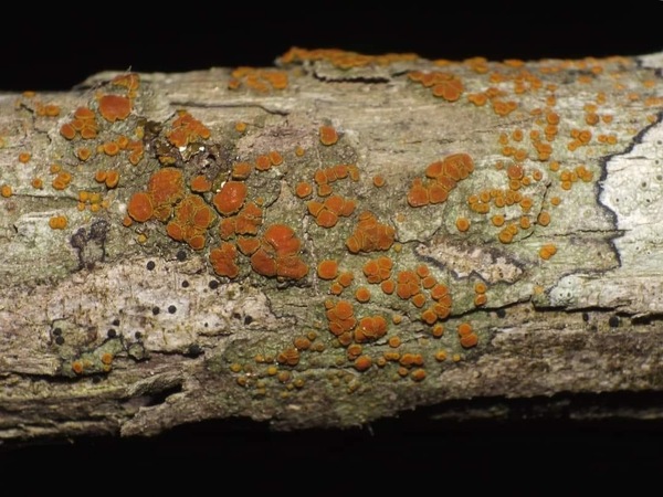
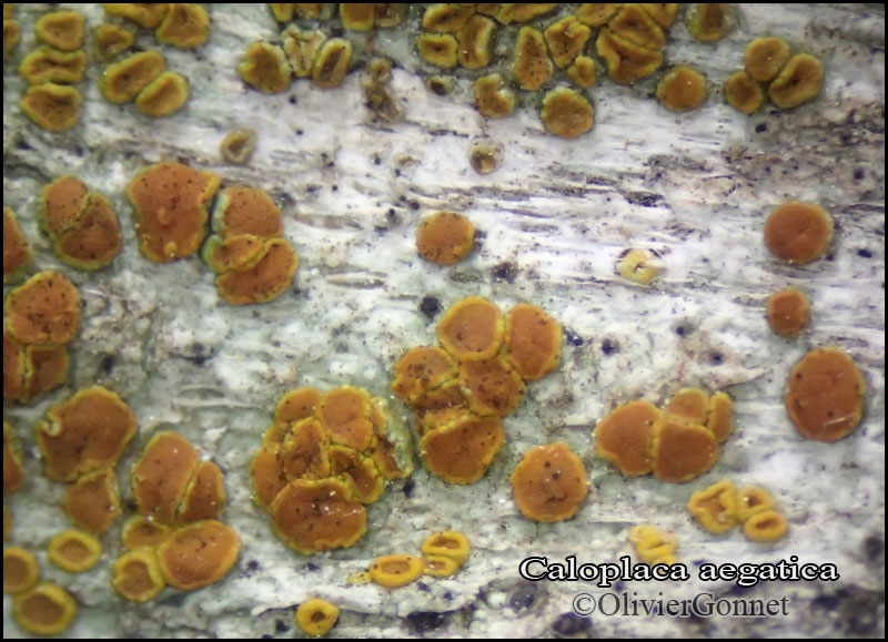
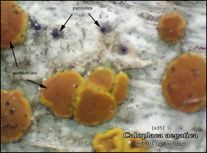
Courtesy: Olivier et Danièle Gonnet - Source: https://www.afl-lichenologie.fr/Photos_AFL/Photos_AFL_C/Textes_C5/Caloplaca_aegatica.htm
France, sur Quercus ilex - Paragan Fénu - Corse
11/10/2015
Courtesy: Olivier et Danièle Gonnet - Source: https://www.afl-lichenologie.fr/Photos_AFL/Photos_AFL_C/Textes_C5/Caloplaca_aegatica.htm
France, sur Quercus ilex - Paragan Fénu - Corse
11/10/2015
Courtesy: Olivier et Danièle Gonnet - Source: https://www.afl-lichenologie.fr/Photos_AFL/Photos_AFL_C/Textes_C5/Caloplaca_aegatica.htm
France, sur Quercus ilex - Paragan Fénu - Corse
11/10/2015
Courtesy: Olivier et Danièle Gonnet - Source: https://www.afl-lichenologie.fr/Photos_AFL/Photos_AFL_C/Textes_C5/Caloplaca_aegatica.htm
France, sur Quercus ilex - Paragan Fénu - Corse
11/10/2015
Courtesy: Olivier et Danièle Gonnet - Source: https://www.afl-lichenologie.fr/Photos_AFL/Photos_AFL_C/Textes_C5/Caloplaca_aegatica.htm
France, sur Quercus ilex - Paragan Fénu - Corse
11/10/2015

Courtesy: Olivier et Danièle Gonnet - Source: https://www.afl-lichenologie.fr/Photos_AFL/Photos_AFL_C/Textes_C5/Caloplaca_aegatica.htm
France, sur Quercus ilex - Paragan Fénu - Corse
11/10/2015
Growth form: Crustose
Substrata: bark
Photobiont: green algae other than Trentepohlia
Reproductive strategy: mainly sexual
Most common in areas with a humid-warm climate (e.g. most of Tyrrenian Italy)
Taxon bound to maritime-coastal situations
Commonnes-rarity: (info)
Alpine belt: absent
Subalpine belt: absent
Oromediterranean belt: absent
Montane belt: absent
Submediterranean belt: absent
Padanian area: absent
Humid submediterranean belt: extremely rare
Humid mediterranean belt: rare
Dry mediterranean belt: absent
Predictive model
| Herbarium samples |
Felix Schumm; Owner: CC BY-SA 4.0
[TSB_31446], Spain, Canary Islands, Tenerife, Teno-mountains, W of Teno Alto, 28°20’35’’ N, 16°52’40’’ W, 700-750 m, on dead twigs of Chamaecytisus proliferus. Leg. et det. J. Hafellner, 16.12-1998. OBERMAYER, LICHENOTHECA GRAECENSIS FASC. 7-8, NR. 126.
P.L. Nimis; Owner: Department of Life Sciences, University of Trieste
Herbarium: TSB (31446)
2002/12/02
A. Moro; Owner: Department of Life Sciences, University of Trieste
Sicilia, TP, Isola di Marettimo
2008.04.03

A. Moro; Owner: Department of Life Sciences, University of Trieste
Sicilia, TP, Isola di Marettimo
2008.04.03
Felix Schumm; Owner: CC BY-SA 4.0
[TSB_31446], Spain, Canary Islands, Tenerife, Teno-mountains, W of Teno Alto, 28°20’35’’ N, 16°52’40’’ W, 700-750 m, on dead twigs of Chamaecytisus proliferus. Leg. et det. J. Hafellner, 16.12-1998. OBERMAYER, LICHENOTHECA GRAECENSIS FASC. 7-8, NR. 126.

P.L. Nimis; Owner: Department of Life Sciences, University of Trieste
Herbarium: TSB (31446)
2001/11/19
apothecia and the typical black pycnidia
Felix Schumm – CC BY-SA 4.0
[7193], Spanien, Kanarische Inseln, Teneriffa, Teno Gebirge, Im Barranco de las Cuevas Negras, Lorbeerwaldreste, auf Laubbaum. Leg. Schumm 20.03.1978, det. Sipman 2009

Felix Schumm – CC BY-SA 4.0
[7193], Spanien, Kanarische Inseln, Teneriffa, Teno Gebirge, Im Barranco de las Cuevas Negras, Lorbeerwaldreste, auf Laubbaum. Leg. Schumm 20.03.1978, det. Sipman 2009

Felix Schumm – CC BY-SA 4.0
[7193], Spanien, Kanarische Inseln, Teneriffa, Teno Gebirge, Im Barranco de las Cuevas Negras, Lorbeerwaldreste, auf Laubbaum. Leg. Schumm 20.03.1978, det. Sipman 2009

Felix Schumm – CC BY-SA 4.0
[7193], Spanien, Kanarische Inseln, Teneriffa, Teno Gebirge, Im Barranco de las Cuevas Negras, Lorbeerwaldreste, auf Laubbaum. Leg. Schumm 20.03.1978, det. Sipman 2009
Felix Schumm – CC BY-SA 4.0
[7193], Spanien, Kanarische Inseln, Teneriffa, Teno Gebirge, Im Barranco de las Cuevas Negras, Lorbeerwaldreste, auf Laubbaum. Leg. Schumm 20.03.1978, det. Sipman 2009

Felix Schumm – CC BY-SA 4.0
[7193], Spanien, Kanarische Inseln, Teneriffa, Teno Gebirge, Im Barranco de las Cuevas Negras, Lorbeerwaldreste, auf Laubbaum. Leg. Schumm 20.03.1978, det. Sipman 2009

Felix Schumm – CC BY-SA 4.0
[7193], Spanien, Kanarische Inseln, Teneriffa, Teno Gebirge, Im Barranco de las Cuevas Negras, Lorbeerwaldreste, auf Laubbaum. Leg. Schumm 20.03.1978, det. Sipman 2009
Felix Schumm – CC BY-SA 4.0
[7193], Spanien, Kanarische Inseln, Teneriffa, Teno Gebirge, Im Barranco de las Cuevas Negras, Lorbeerwaldreste, auf Laubbaum. Leg. Schumm 20.03.1978, det. Sipman 2009

Felix Schumm – CC BY-SA 4.0
[7193], Spanien, Kanarische Inseln, Teneriffa, Teno Gebirge, Im Barranco de las Cuevas Negras, Lorbeerwaldreste, auf Laubbaum. Leg. Schumm 20.03.1978, det. Sipman 2009
Felix Schumm – CC BY-SA 4.0
[7193], Spanien, Kanarische Inseln, Teneriffa, Teno Gebirge, Im Barranco de las Cuevas Negras, Lorbeerwaldreste, auf Laubbaum. Leg. Schumm 20.03.1978, det. Sipman 2009
Felix Schumm – CC BY-SA 4.0
[7193], Spanien, Kanarische Inseln, Teneriffa, Teno Gebirge, Im Barranco de las Cuevas Negras, Lorbeerwaldreste, auf Laubbaum. Leg. Schumm 20.03.1978, det. Sipman 2009

Felix Schumm – CC BY-SA 4.0
[7193], Spanien, Kanarische Inseln, Teneriffa, Teno Gebirge, Im Barranco de las Cuevas Negras, Lorbeerwaldreste, auf Laubbaum. Leg. Schumm 20.03.1978, det. Sipman 2009

Felix Schumm – CC BY-SA 4.0
[7193], Spanien, Kanarische Inseln, Teneriffa, Teno Gebirge, Im Barranco de las Cuevas Negras, Lorbeerwaldreste, auf Laubbaum. Leg. Schumm 20.03.1978, det. Sipman 2009
Felix Schumm - CC BY-SA 4.0
[6894], Spanien, Kanarische Inseln, Gran Canaria; an der Strasse von El Tablero zum Embalse de Chira oberhalb Cercados de Espinas; nordexponierter steiler Felshang; 27°52.165’ N, 15°38.905’ W, Höhe 850 m. Leg. F. Schumm & U. Schwarz 05.01.2000, det. H. Sipmann 2016.
Felix Schumm - CC BY-SA 4.0
[6894], Spanien, Kanarische Inseln, Gran Canaria; an der Strasse von El Tablero zum Embalse de Chira oberhalb Cercados de Espinas; nordexponierter steiler Felshang; 27°52.165’ N, 15°38.905’ W, Höhe 850 m. Leg. F. Schumm & U. Schwarz 05.01.2000, det. H. Sipmann 2016.

Felix Schumm - CC BY-SA 4.0
[6894], Spanien, Kanarische Inseln, Gran Canaria; an der Strasse von El Tablero zum Embalse de Chira oberhalb Cercados de Espinas; nordexponierter steiler Felshang; 27°52.165’ N, 15°38.905’ W, Höhe 850 m. Leg. F. Schumm & U. Schwarz 05.01.2000, det. H. Sipmann 2016.
Felix Schumm - CC BY-SA 4.0
[6894], Spanien, Kanarische Inseln, Gran Canaria; an der Strasse von El Tablero zum Embalse de Chira oberhalb Cercados de Espinas; nordexponierter steiler Felshang; 27°52.165’ N, 15°38.905’ W, Höhe 850 m. Leg. F. Schumm & U. Schwarz 05.01.2000, det. H. Sipmann 2016.
Felix Schumm - CC BY-SA 4.0
[5429], Spanien, Gran Canaria, Barranco de Los Tilos südlich Moya, 28°04.766’ N, 15°35.935’ W, Höhe 620 m. Leg. F. Schumm & U. Schwarz 28.12.1998, det. A. Aptroot 2016.
Felix Schumm - CC BY-SA 4.0
[5429], Spanien, Gran Canaria, Barranco de Los Tilos südlich Moya, 28°04.766’ N, 15°35.935’ W, Höhe 620 m. Leg. F. Schumm & U. Schwarz 28.12.1998, det. A. Aptroot 2016.
Felix Schumm - CC BY-SA 4.0
[8634], Portugal, Madeira, an der Straße bei Portela, 32°44,812’ N, W 16°49,623’ W, 575 m, an Zeder. Leg. et det. Schumm 15.04.2001,

Felix Schumm - CC BY-SA 4.0
[8634], Portugal, Madeira, an der Straße bei Portela, 32°44,812’ N, W 16°49,623’ W, 575 m, an Zeder. Leg. et det. Schumm 15.04.2001,

Felix Schumm - CC BY-SA 4.0
[8634], Portugal, Madeira, an der Straße bei Portela, 32°44,812’ N, W 16°49,623’ W, 575 m, an Zeder. Leg. et det. Schumm 15.04.2001,
Felix Schumm - CC BY-SA 4.0
[8634], Portugal, Madeira, an der Straße bei Portela, 32°44,812’ N, W 16°49,623’ W, 575 m, an Zeder. Leg. et det. Schumm 15.04.2001,
Felix Schumm - CC BY-SA 4.0
[8634], Portugal, Madeira, an der Straße bei Portela, 32°44,812’ N, W 16°49,623’ W, 575 m, an Zeder. Leg. et det. Schumm 15.04.2001,
Felix Schumm - CC BY-SA 4.0
[8634], Portugal, Madeira, an der Straße bei Portela, 32°44,812’ N, W 16°49,623’ W, 575 m, an Zeder. Leg. et det. Schumm 15.04.2001,

Felix Schumm - CC BY-SA 4.0
[8634], Portugal, Madeira, an der Straße bei Portela, 32°44,812’ N, W 16°49,623’ W, 575 m, an Zeder. Leg. et det. Schumm 15.04.2001,
Felix Schumm - CC BY-SA 4.0
[9152], Spanien, Kanaren, La Gomera: Chorros de Epina, zwischen Arure und Vallehermoso, im Lorbeer-Erica Wald, 28°09.830' N, 17°17.852 W, 750-850 m, an Ästen. Leg. F. Schumm, 10.02.2002, det. A. Aptroot 2016.

Felix Schumm - CC BY-SA 4.0
[9152], Spanien, Kanaren, La Gomera: Chorros de Epina, zwischen Arure und Vallehermoso, im Lorbeer-Erica Wald, 28°09.830' N, 17°17.852 W, 750-850 m, an Ästen. Leg. F. Schumm, 10.02.2002, det. A. Aptroot 2016.
Felix Schumm - CC BY-SA 4.0
[9397], Spanien, Kanaren, La Gomera, bei Arure an der Straße nach Las Hayas, trockener Abhang mit Felsblöcken und Euphorbia. 28°07.895 N, 17°18.983 W, 870 m, an Euphorbia. Leg. F. Schumm, 14.02.2002, det. A. Aptroot 2016.

Felix Schumm - CC BY-SA 4.0
[9397], Spanien, Kanaren, La Gomera, bei Arure an der Straße nach Las Hayas, trockener Abhang mit Felsblöcken und Euphorbia. 28°07.895 N, 17°18.983 W, 870 m, an Euphorbia. Leg. F. Schumm, 14.02.2002, det. A. Aptroot 2016.
Felix Schumm - CC BY-SA 4.0
[12371], Griechenland, N-Samos, südlich Avlakia an der Straße oberhalb Vourliotes nördlich des Bergmassivs Lazarou, 37°48' N, 26°51' E, ca. 776 m. Leg. F. Schumm, R. Düll & Maier, 03.05.2006, det A. Aptroot 2016.

Felix Schumm - CC BY-SA 4.0
[12371], Griechenland, N-Samos, südlich Avlakia an der Straße oberhalb Vourliotes nördlich des Bergmassivs Lazarou, 37°48' N, 26°51' E, ca. 776 m. Leg. F. Schumm, R. Düll & Maier, 03.05.2006, det A. Aptroot 2016.
Felix Schumm - CC BY-SA 4.0
[12932], Spanien, Kanaren, La Palma (NE), westlich von Los Sauces, auf dem Weg vom Centro de Visitanjes Los Tilos (28°47.565' N, 17°48.009' W, ca. 500 m) zum Mirador Espigon Atravesado (754 m); Lorbeerwald, on bark. Leg. F. Schumm 15.01.2007, det. A. Aptroot. 2016.

Felix Schumm - CC BY-SA 4.0
[12932], Spanien, Kanaren, La Palma (NE), westlich von Los Sauces, auf dem Weg vom Centro de Visitanjes Los Tilos (28°47.565' N, 17°48.009' W, ca. 500 m) zum Mirador Espigon Atravesado (754 m); Lorbeerwald, on bark. Leg. F. Schumm 15.01.2007, det. A. Aptroot. 2016.
Felix Schumm - CC BY-SA 4.0
[13020], Spanien, Kanaren, La Palma (NE), südwestlich von Santa Cruz beim Mirador de la Cumbre am Straßenrand der Straße LP-2; 28°39.547' N, 17°48.796' W, ca. 920 m. Leg. F. Schumm,18.01.2007, det. A. Aptroot 2016.
Felix Schumm - CC BY-SA 4.0
[13020], Spanien, Kanaren, La Palma (NE), südwestlich von Santa Cruz beim Mirador de la Cumbre am Straßenrand der Straße LP-2; 28°39.547' N, 17°48.796' W, ca. 920 m. Leg. F. Schumm,18.01.2007, det. A. Aptroot 2016.

Felix Schumm - CC BY-SA 4.0
[13110], Spanien, Kanaren, La Palma (NE), Lorbeer-Erica-Wald an der Straße von San Pedro zum Refugio El Pilar oberhalb San Isidro, on bark, 28°37.784' N, 17°48.743' W, ca 700 m. Leg. F. Schumm, 23.01.2007, det. A. Aptroot 2016.

Felix Schumm - CC BY-SA 4.0
[13110], Spanien, Kanaren, La Palma (NE), Lorbeer-Erica-Wald an der Straße von San Pedro zum Refugio El Pilar oberhalb San Isidro, on bark, 28°37.784' N, 17°48.743' W, ca 700 m. Leg. F. Schumm, 23.01.2007, det. A. Aptroot 2016.
Felix Schumm - CC BY-SA 4.0
[13896], Griechenland, NW-Samos: zwischen Kosmadei und Kakoperato, 37°44.998' N, 26°39.195' E, 623 m, an Pinus brutea. Leg F. Schumm & R. Düll, 17.05.2008, det. A. Aptroot 2016.

Felix Schumm - CC BY-SA 4.0
[13896], Griechenland, NW-Samos: zwischen Kosmadei und Kakoperato, 37°44.998' N, 26°39.195' E, 623 m, an Pinus brutea. Leg F. Schumm & R. Düll, 17.05.2008, det. A. Aptroot 2016.

Felix Schumm - CC BY-SA 4.0
[13896], Griechenland, NW-Samos: zwischen Kosmadei und Kakoperato, 37°44.998' N, 26°39.195' E, 623 m, an Pinus brutea. Leg F. Schumm & R. Düll, 17.05.2008, det. A. Aptroot 2016.
Felix Schumm - CC BY-SA 4.0
[13896], Griechenland, NW-Samos: zwischen Kosmadei und Kakoperato, 37°44.998' N, 26°39.195' E, 623 m, an Pinus brutea. Leg F. Schumm & R. Düll, 17.05.2008, det. A. Aptroot 2016.

Felix Schumm - CC BY-SA 4.0
[13974], Griechenland, N-Samos, nördlich des Mt. Lazarou oberhalb Monasterio Vronda, 37°45.836' N, 26°51.012' E, 850 m. Leg. F. Schumm & R. Düll, 20.05.2008, det. A. Aptroot 2016.

Felix Schumm - CC BY-SA 4.0
[13974], Griechenland, N-Samos, nördlich des Mt. Lazarou oberhalb Monasterio Vronda, 37°45.836' N, 26°51.012' E, 850 m. Leg. F. Schumm & R. Düll, 20.05.2008, det. A. Aptroot 2016.

Felix Schumm - CC BY-SA 4.0
[13974], Griechenland, N-Samos, nördlich des Mt. Lazarou oberhalb Monasterio Vronda, 37°45.836' N, 26°51.012' E, 850 m. Leg. F. Schumm & R. Düll, 20.05.2008, det. A. Aptroot 2016.
Felix Schumm - CC BY-SA 4.0
[16359], Mallorca (Süd): Nationalpark; 39.34322° N, 3.16764° E, 40 m. Leg. F. Schumm, J.-P. Frahm & M. Lüth, 12.03.2010, det. A. Aptroot 2016.
Felix Schumm - CC BY-SA 4.0
[16359], Mallorca (Süd): Nationalpark; 39.34322° N, 3.16764° E, 40 m. Leg. F. Schumm, J.-P. Frahm & M. Lüth, 12.03.2010, det. A. Aptroot 2016.

Felix Schumm - CC BY-SA 4.0
[17331], Portugal, Azoren, Sao Miguel, Ufer des Lagoa Azul, 37.87493° N, 25.79012° W, 260 m, an Cryptomeria japonica. Leg. F. Schumm & J.-P- Frahm, 19.09.2011, det. A. Aptroot 2016.

Felix Schumm - CC BY-SA 4.0
[17331], Portugal, Azoren, Sao Miguel, Ufer des Lagoa Azul, 37.87493° N, 25.79012° W, 260 m, an Cryptomeria japonica. Leg. F. Schumm & J.-P- Frahm, 19.09.2011, det. A. Aptroot 2016.

Felix Schumm - CC BY-SA 4.0
[17331], Portugal, Azoren, Sao Miguel, Ufer des Lagoa Azul, 37.87493° N, 25.79012° W, 260 m, an Cryptomeria japonica. Leg. F. Schumm & J.-P- Frahm, 19.09.2011, det. A. Aptroot 2016.

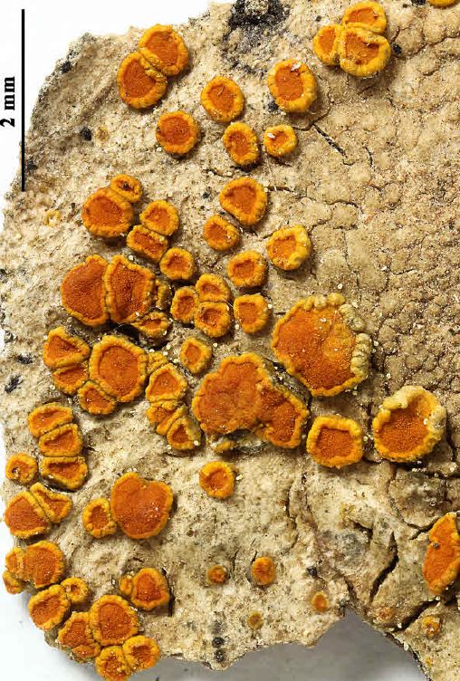
Giulio Pandeli
Italy, Toscana, dune costiere,, Prov.. di Livorno
P.L. Nimis CC BY-SA 04
TSB 36729
Courtesy: Olivier et Danièle Gonnet - Source: https://www.afl-lichenologie.fr/Photos_AFL/Photos_AFL_C/Textes_C5/Caloplaca_aegatica.htm
France, sur Quercus ilex - Paragan Fénu - Corse
11/10/2015
Courtesy: Olivier et Danièle Gonnet - Source: https://www.afl-lichenologie.fr/Photos_AFL/Photos_AFL_C/Textes_C5/Caloplaca_aegatica.htm
France, sur Quercus ilex - Paragan Fénu - Corse
11/10/2015
Courtesy: Olivier et Danièle Gonnet - Source: https://www.afl-lichenologie.fr/Photos_AFL/Photos_AFL_C/Textes_C5/Caloplaca_aegatica.htm
France, sur Quercus ilex - Paragan Fénu - Corse
11/10/2015

Courtesy: Olivier et Danièle Gonnet - Source: https://www.afl-lichenologie.fr/Photos_AFL/Photos_AFL_C/Textes_C5/Caloplaca_aegatica.htm
France, sur Quercus ilex - Paragan Fénu - Corse
11/10/2015
Courtesy: Olivier et Danièle Gonnet - Source: https://www.afl-lichenologie.fr/Photos_AFL/Photos_AFL_C/Textes_C5/Caloplaca_aegatica.htm
France, sur Quercus ilex - Paragan Fénu - Corse
11/10/2015