Villophora microphyllina (Tuck.) S.Y. Kondr.
in Kondratyuk & al., Ukr. Bot. J., 72, 6: 582, 2015. Basionym: Placodium microphyllinum Tuck. - Syn. North Amer. Lich., 1: 174, 1882.
Synonyms: Caloplaca microphyllina (Tuck.) Hasse; Tayloriellina microphyllina (Tuck.) Søchting & Arup
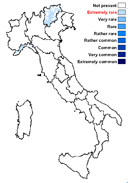
Distribution: N - TAA (Nascimbene & al. 2007b), Lig (LD-1084256).
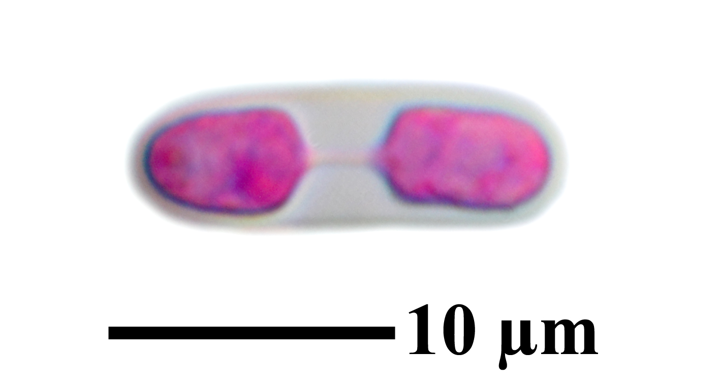
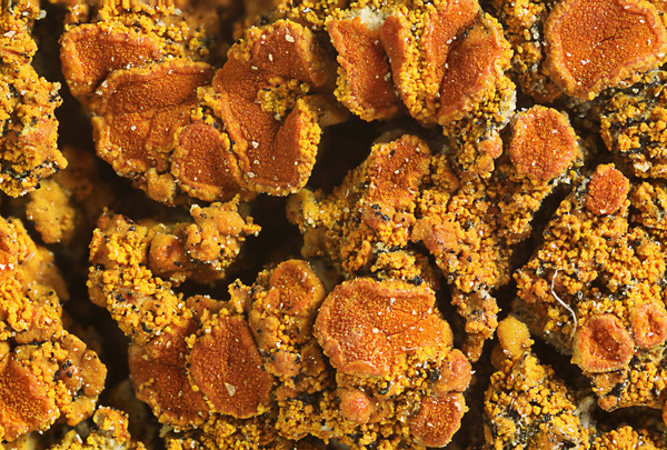
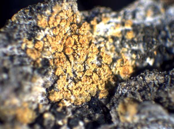
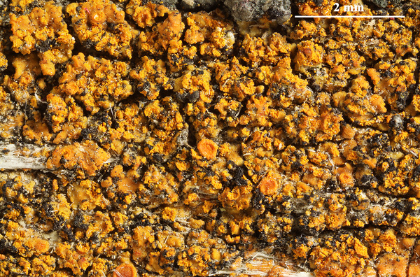
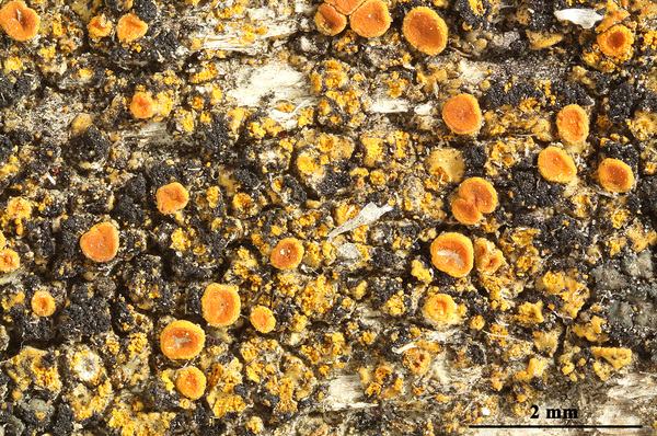
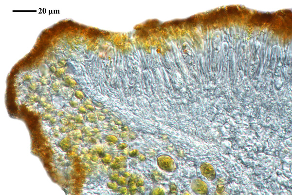
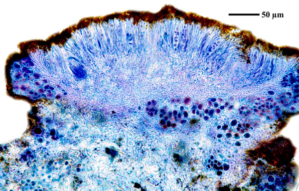
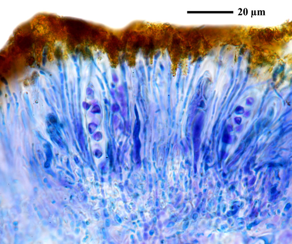
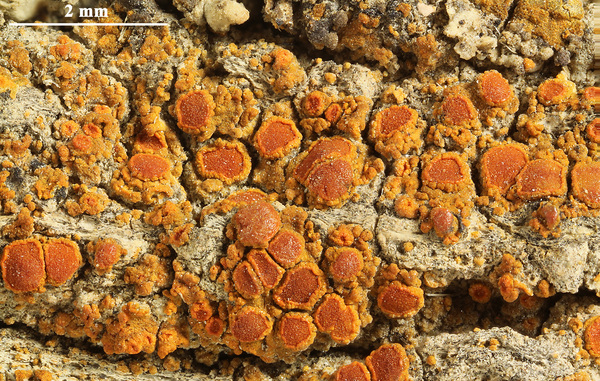
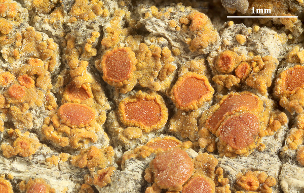
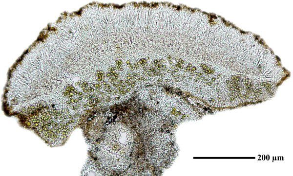
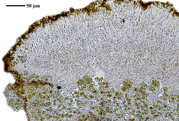
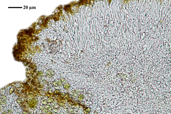
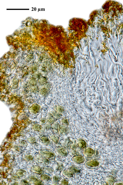
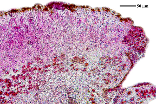
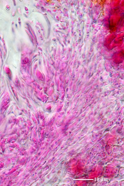
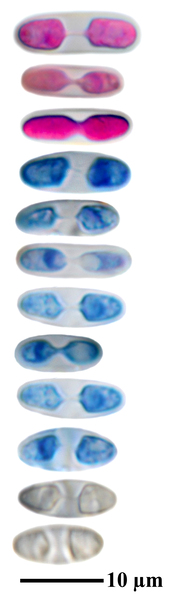
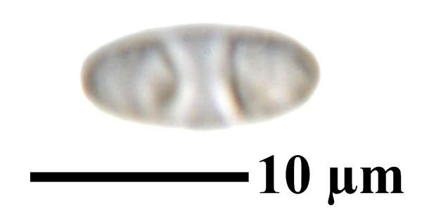
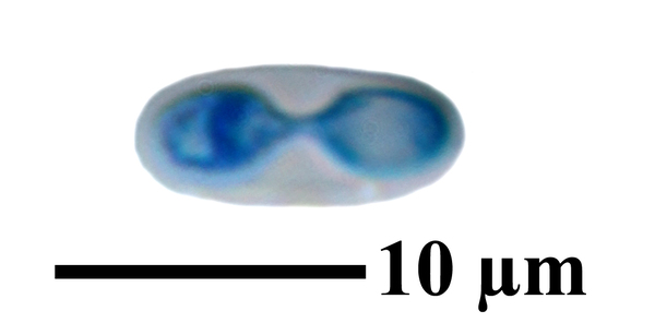
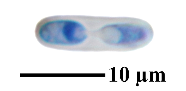
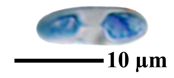
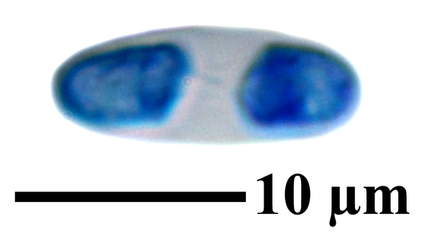
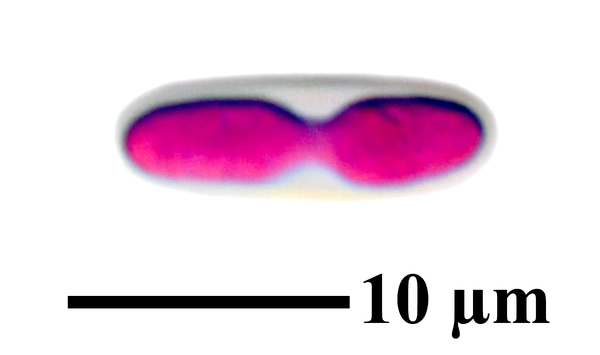
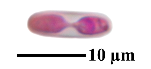
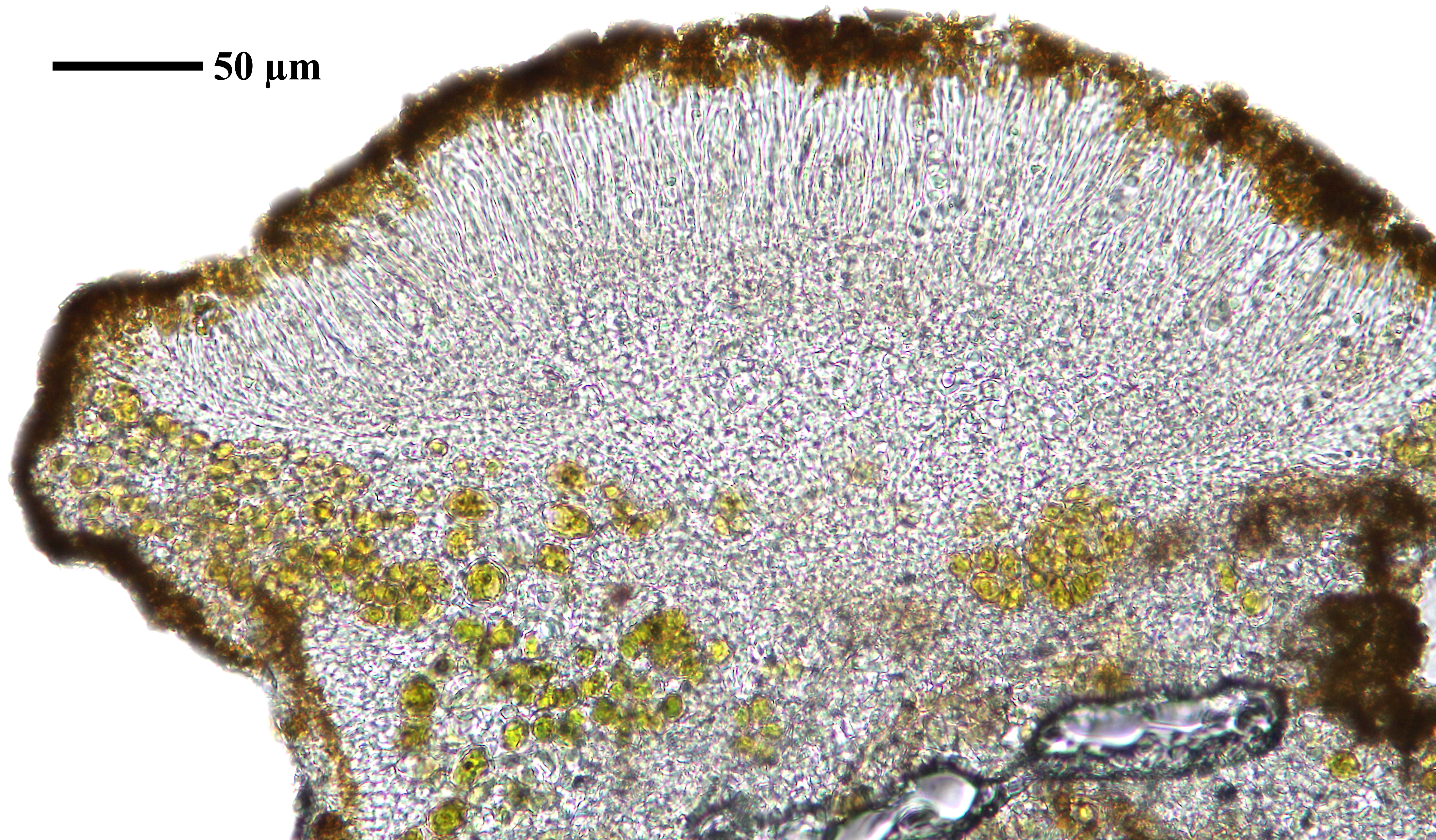
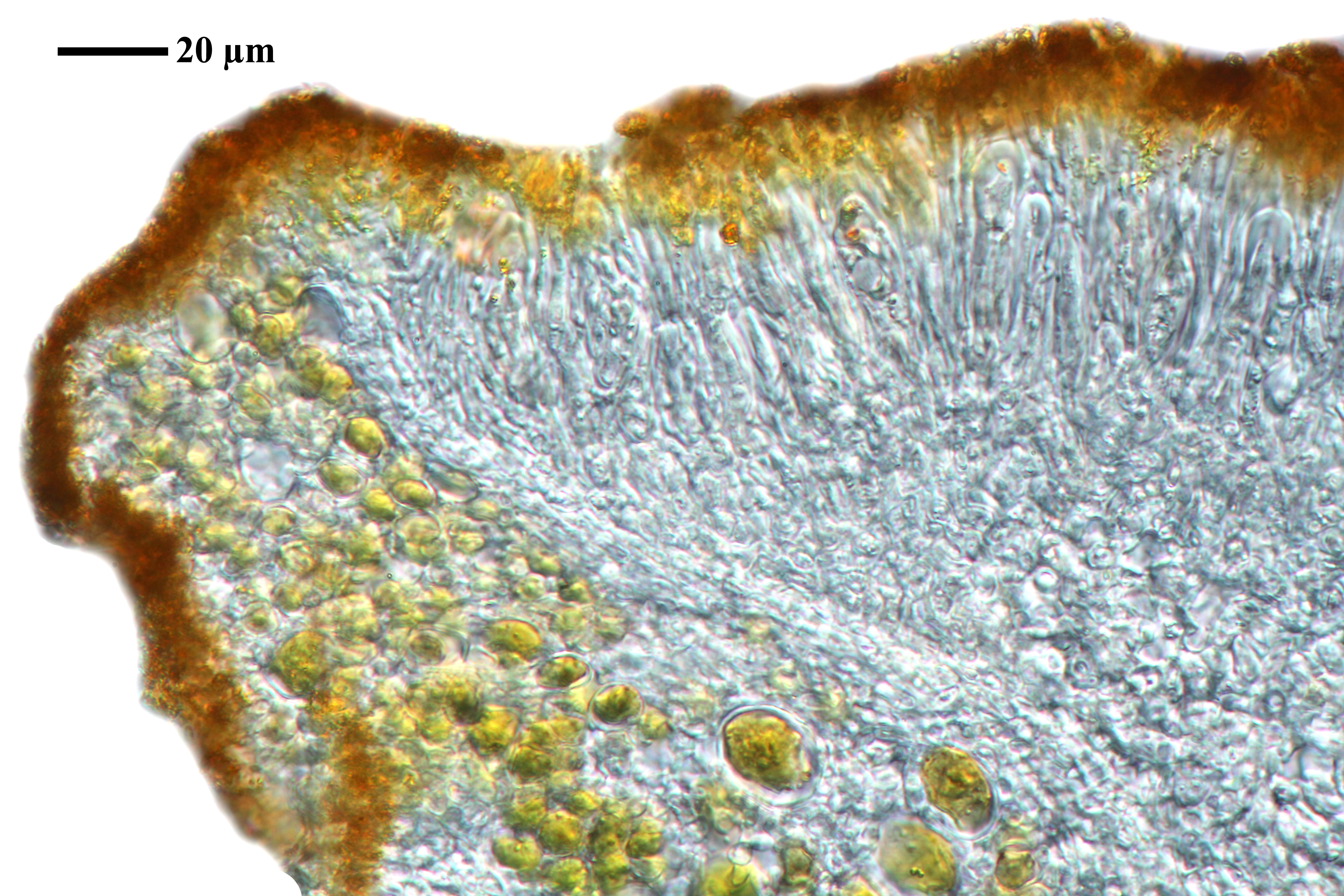
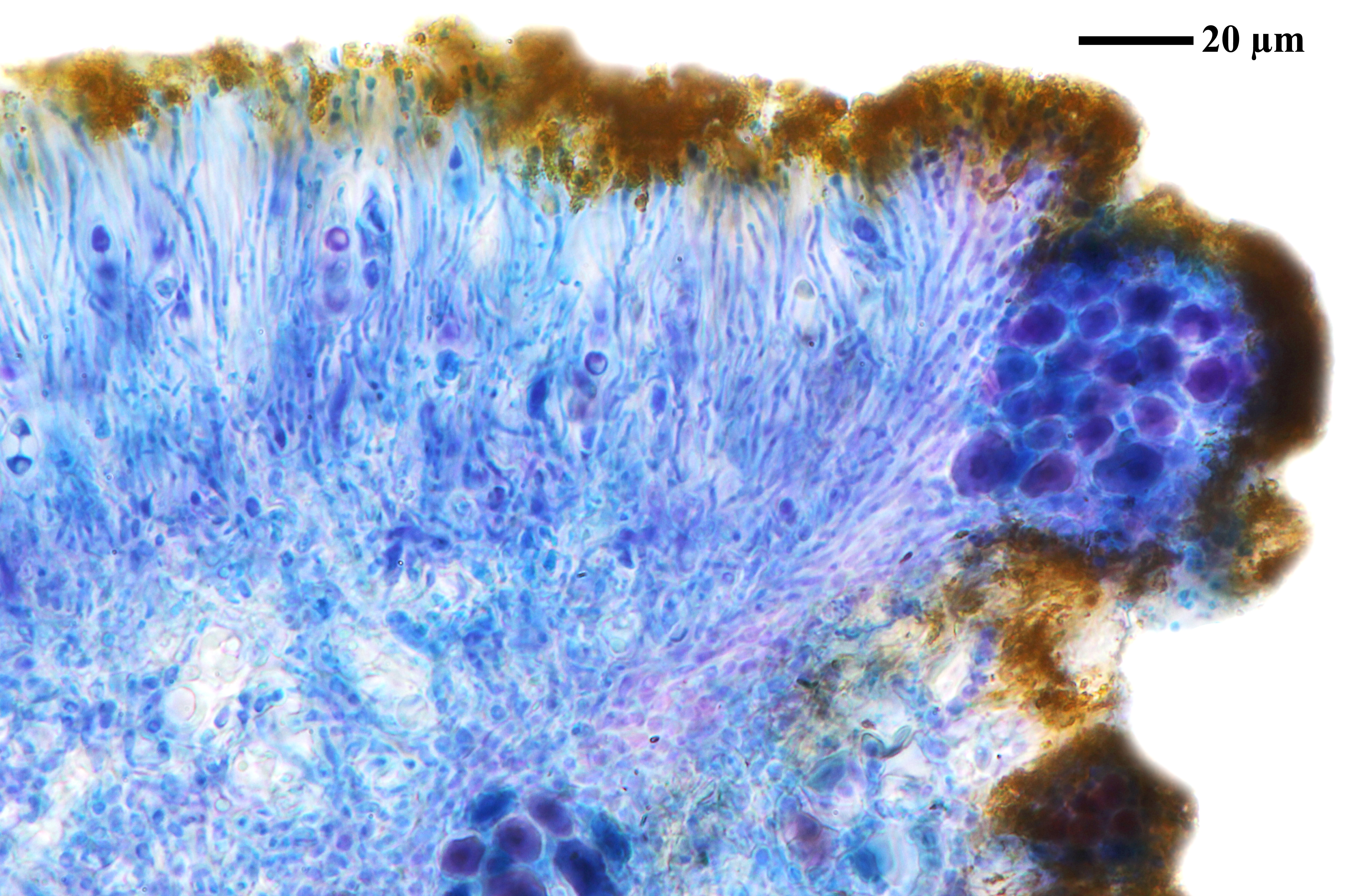
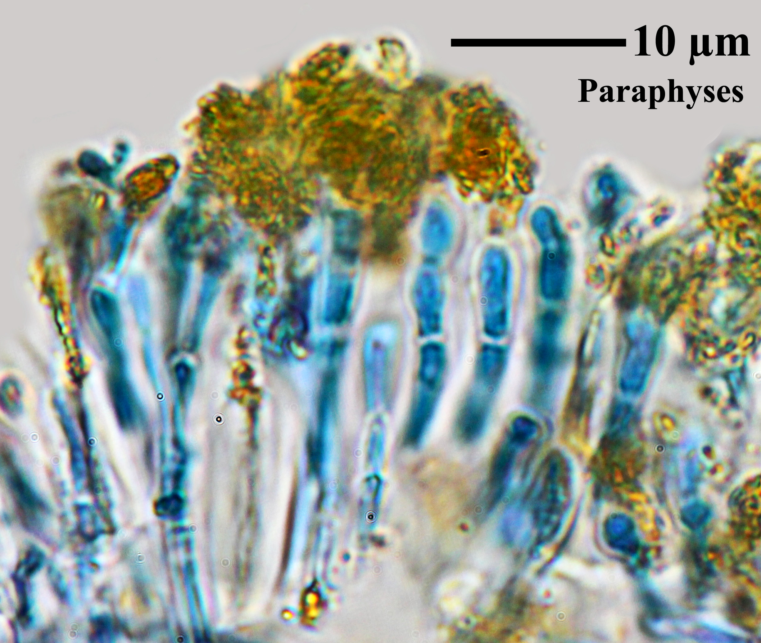
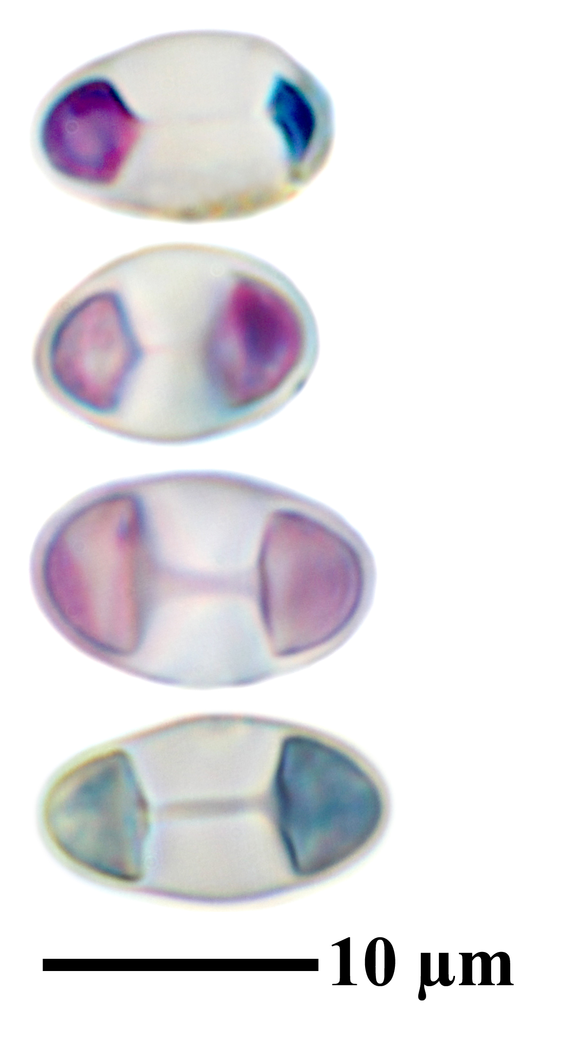
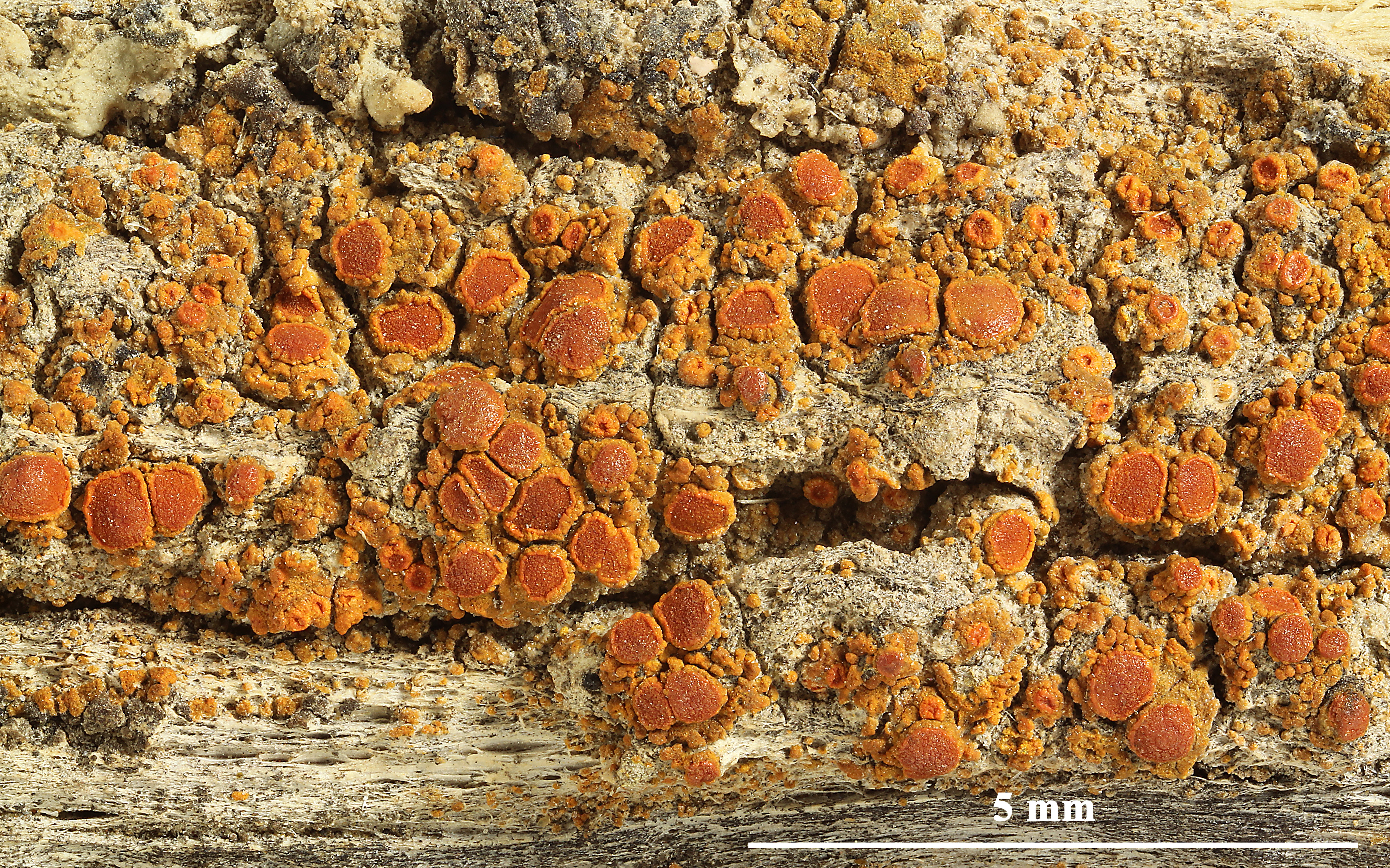
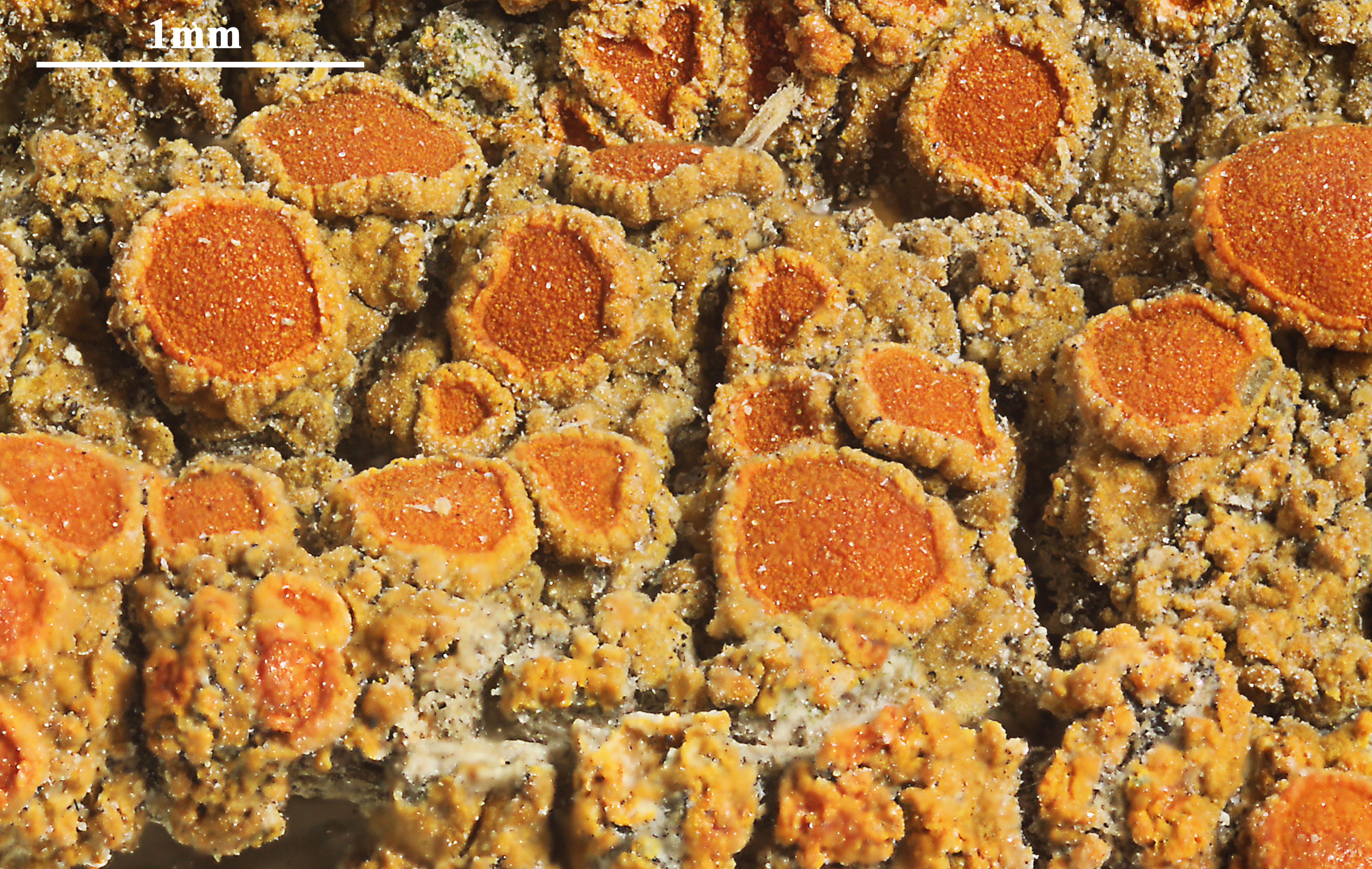
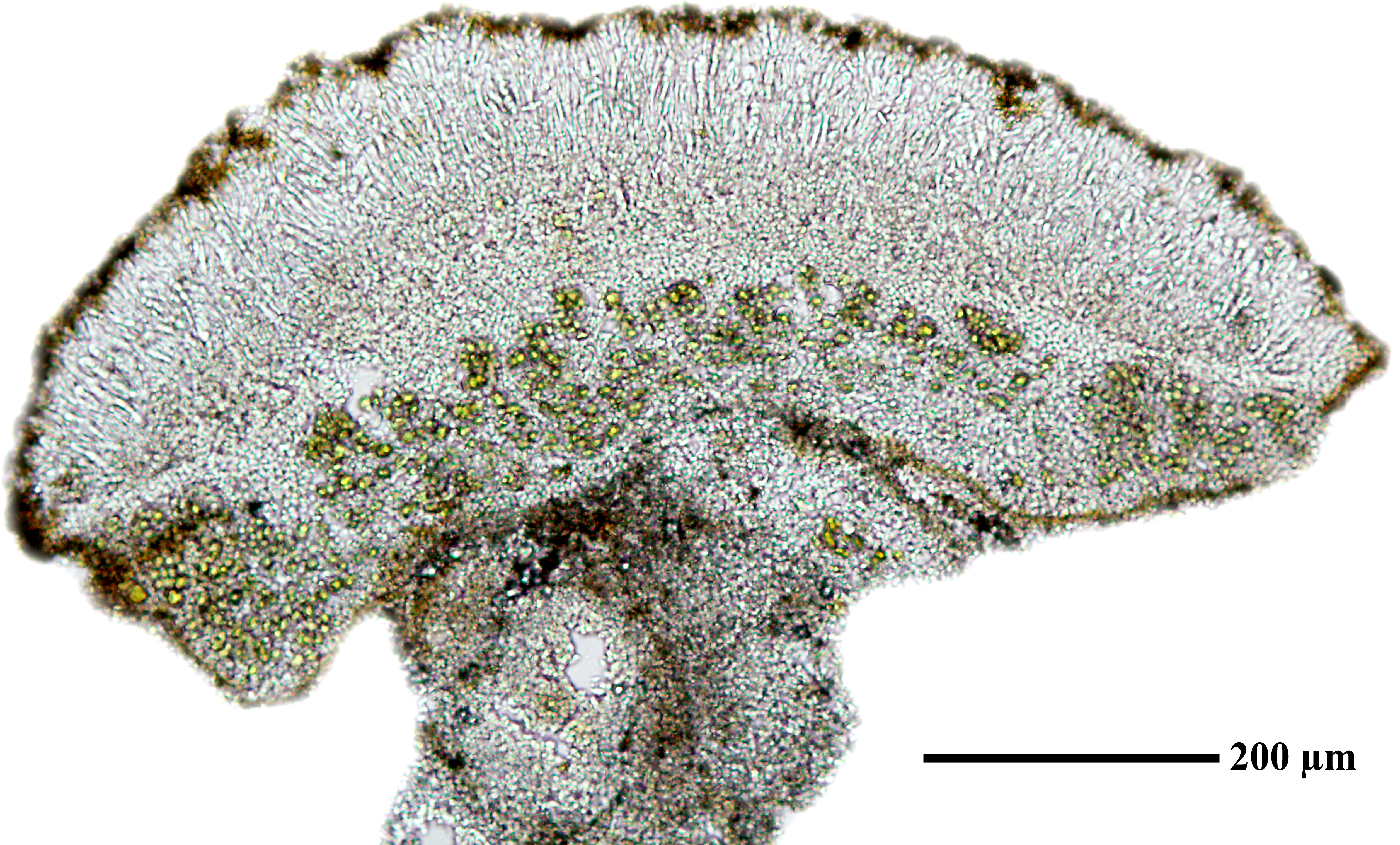
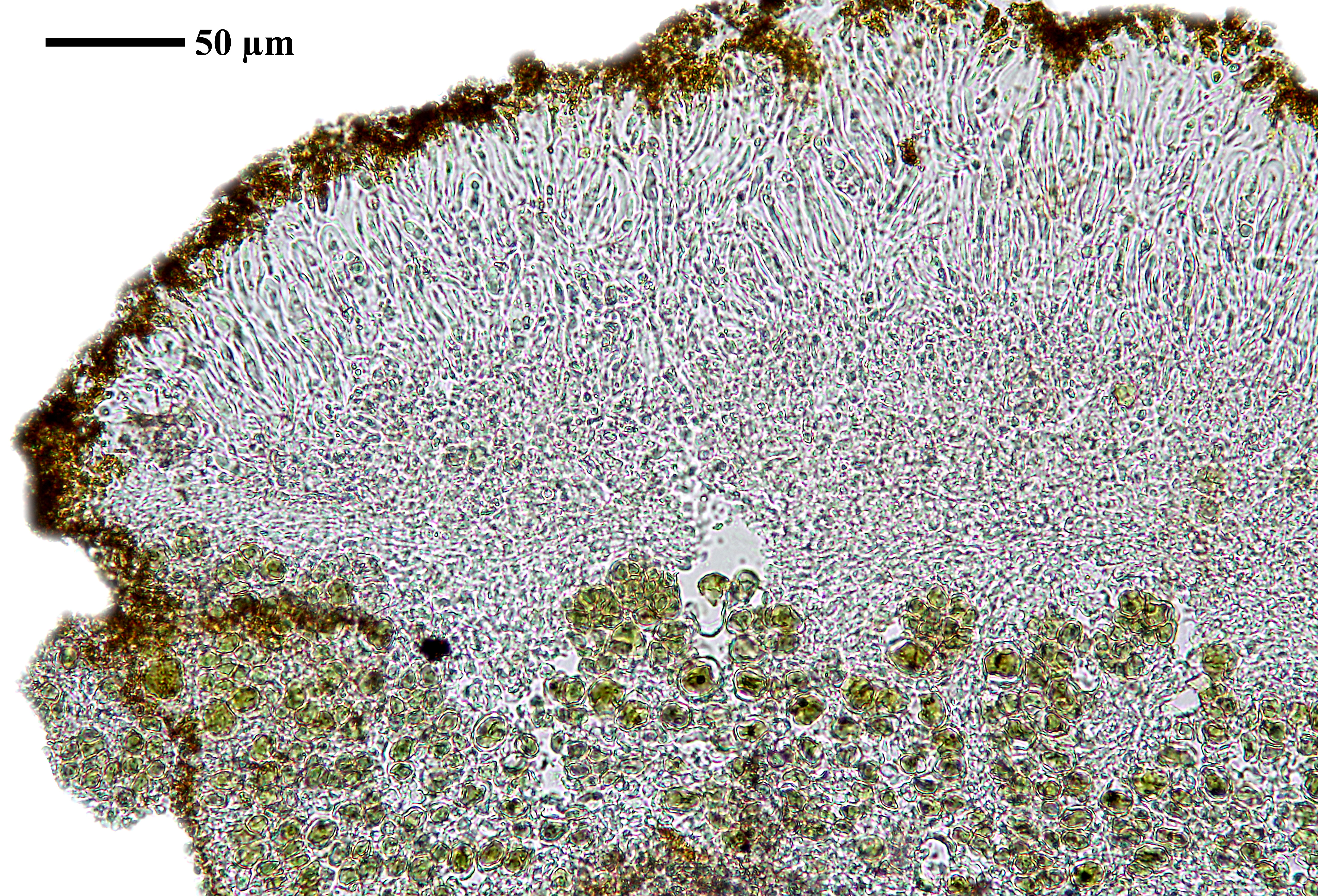
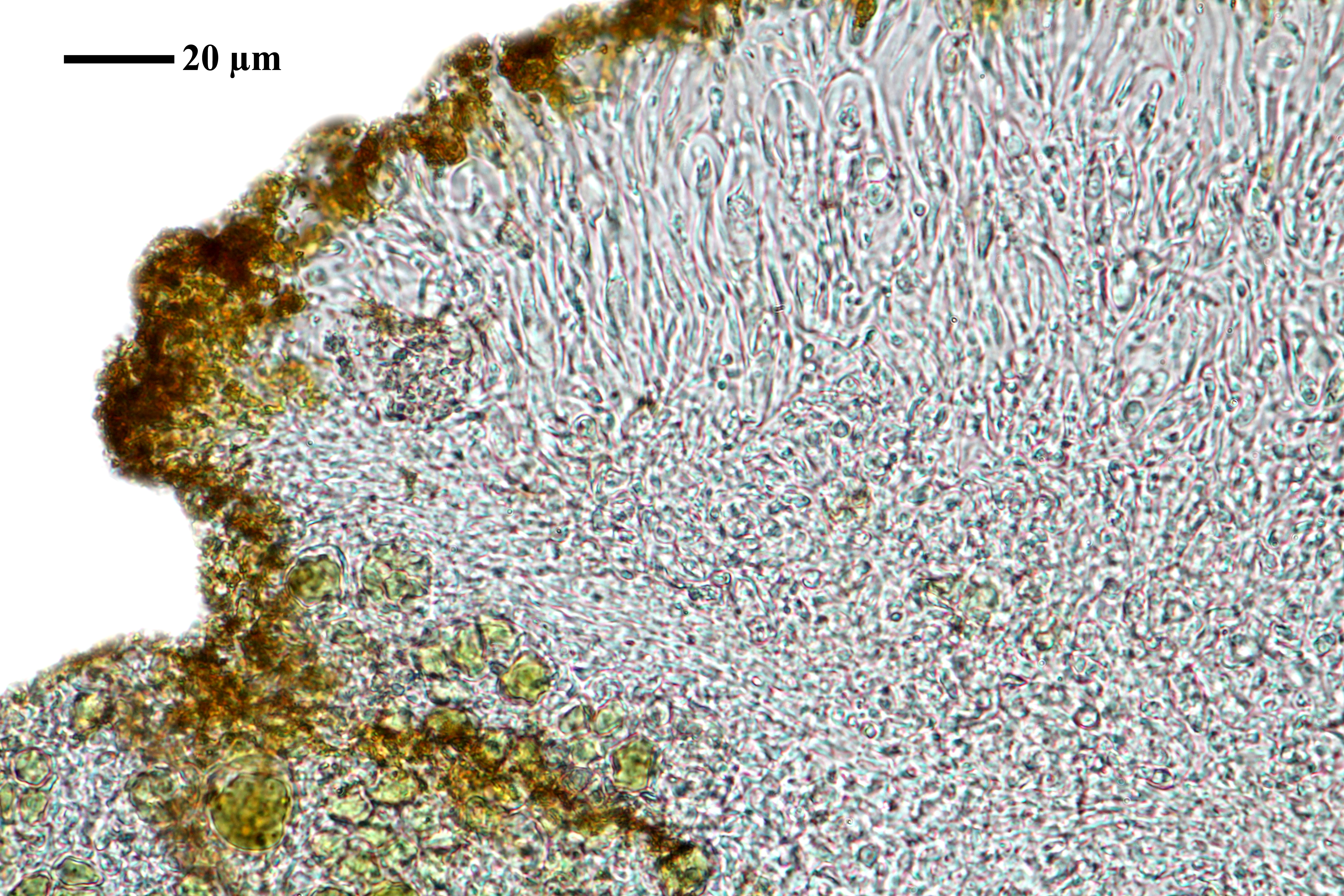
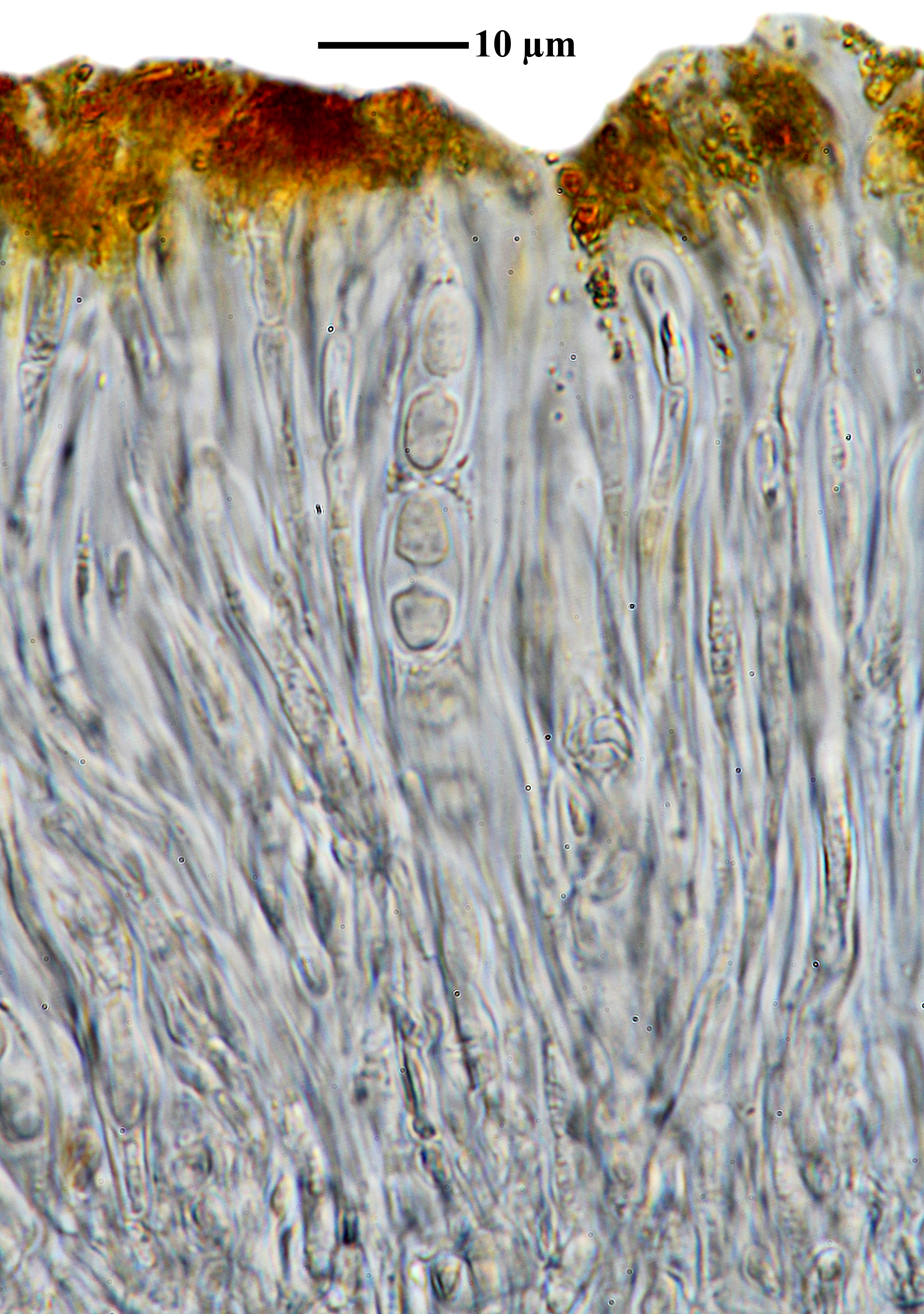
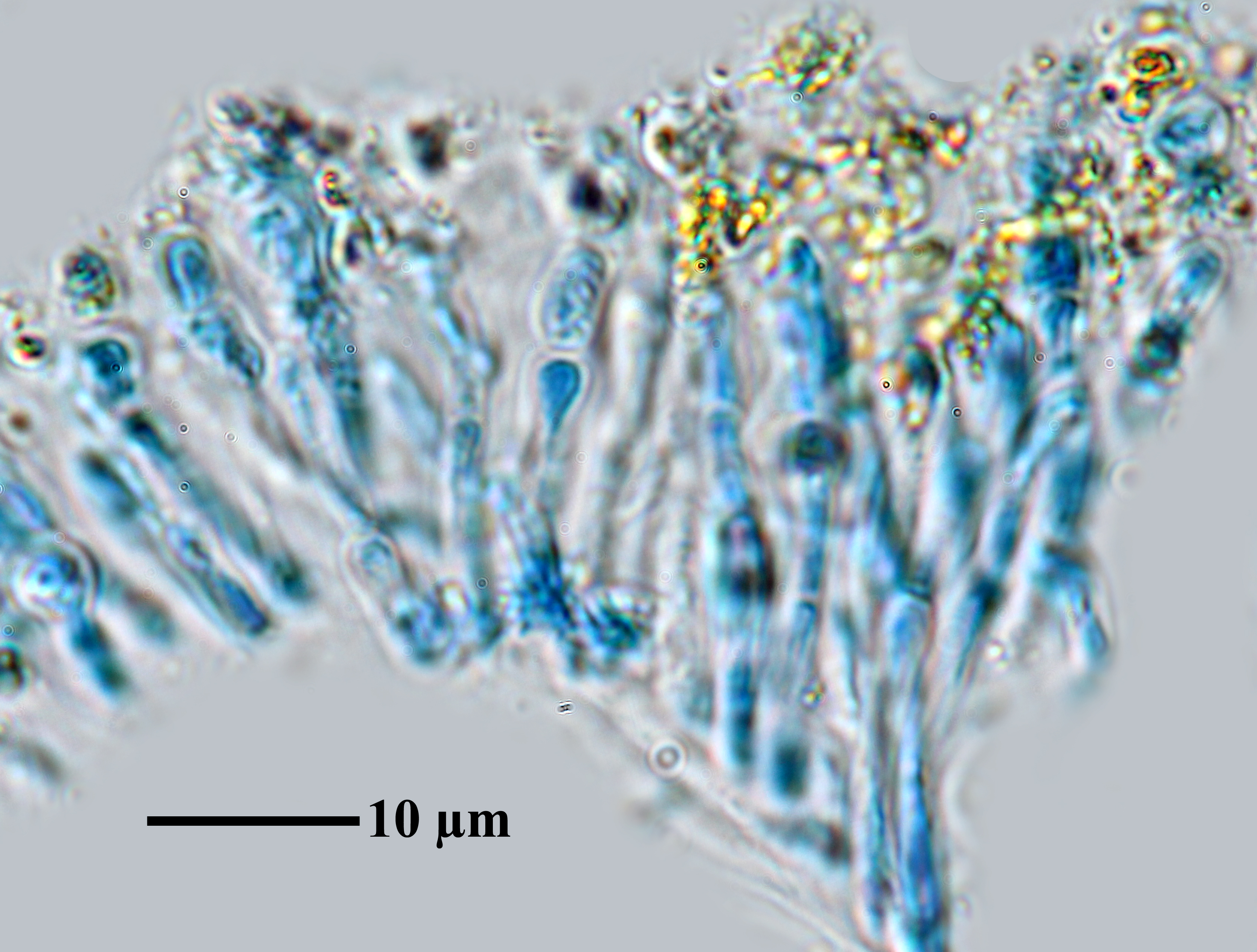
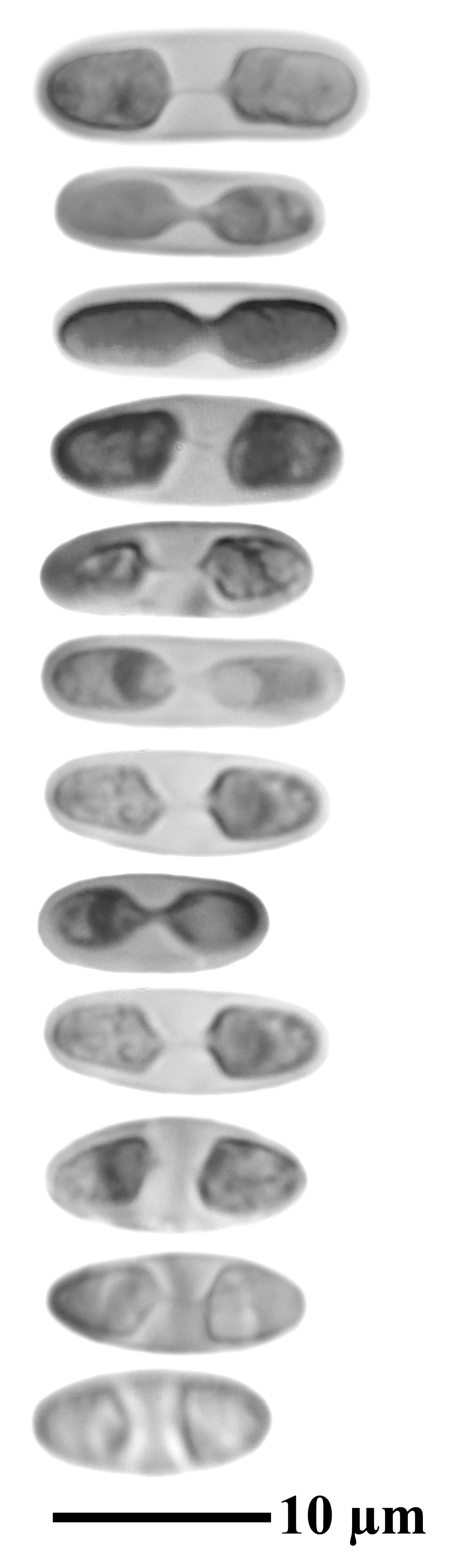
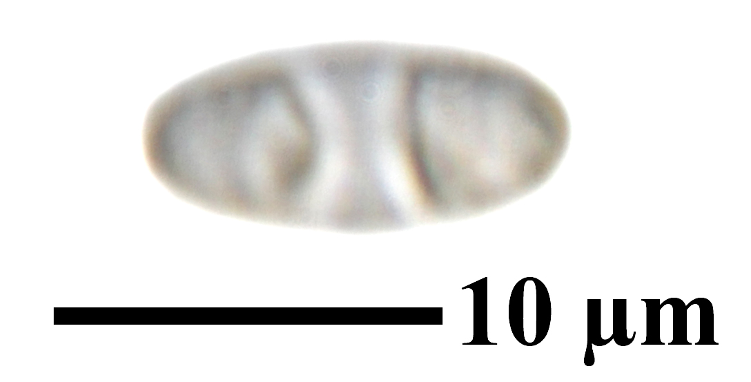
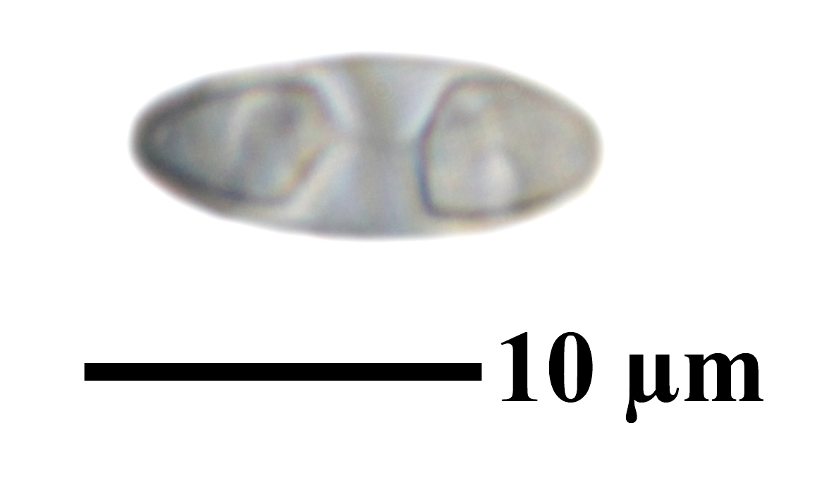
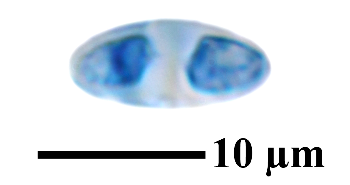
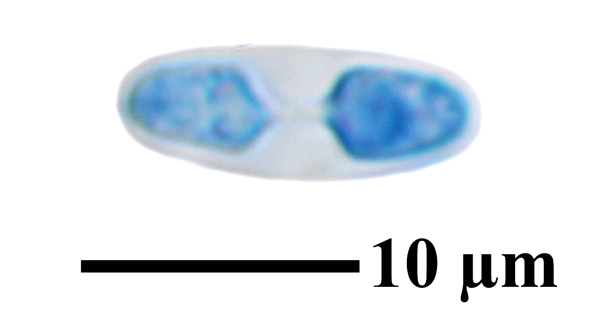
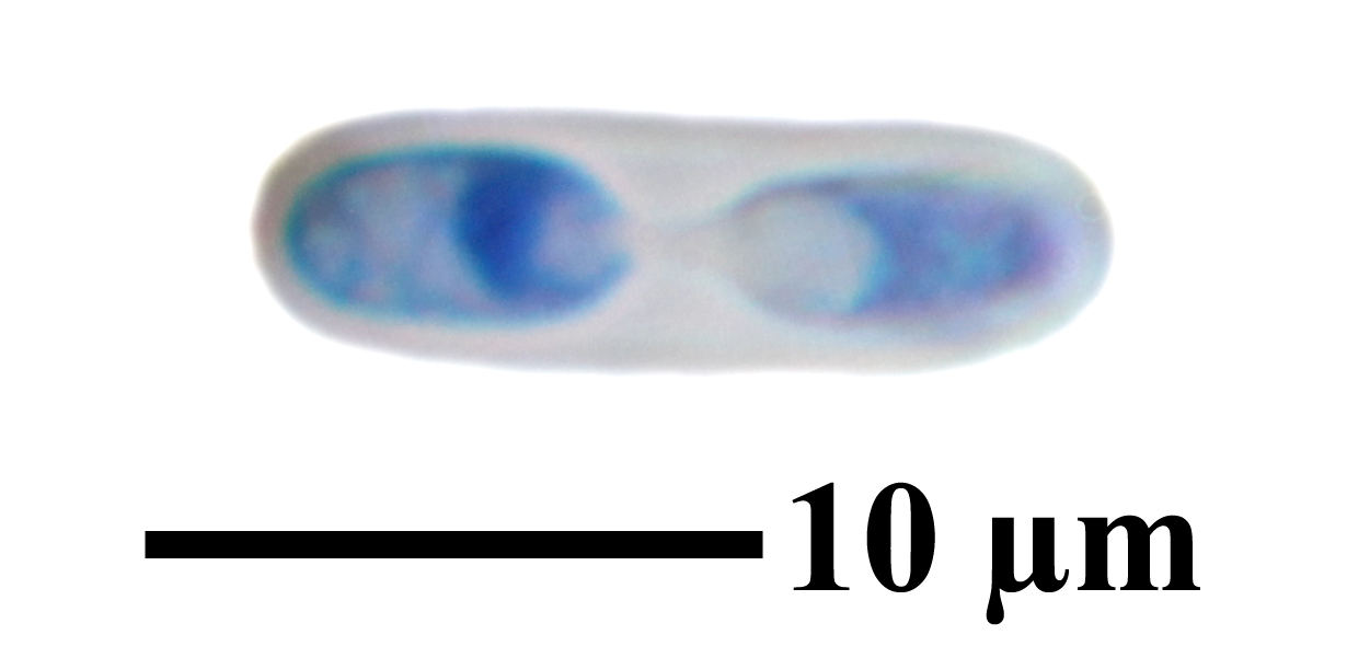
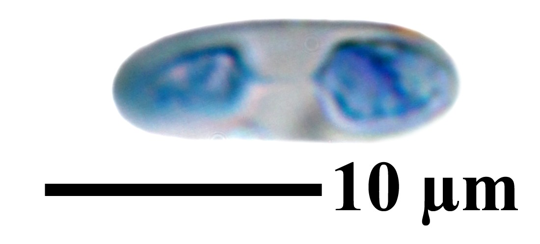
Description: Thallus crustose-areolate to minutely subsquamulose, episubstratic, orange to brownish orange, the areoles flat, distinctly lobed at least in the peripheral part of thalli, with granular soredia in delimited or irregular, laminal or marginal soralia. Upper cortex paraplectenchymatous, 16-35 µm thick; medulla poorly developed, without granules. Apothecia zeorine, adnate, 0.2-1 mm across, with a flat, orange, epruinose disc, a thin proper margin concolorous with disc (or slightly paler), and a persistent, slightly raised thalline margin concolorous with thallus. Proper exciple paraplectenchymatous, extending below the hypothecium; epithecium orange-yellow, K+ red; hymenium colourless; paraphyses often branched in upper part, the terminal cells slightly swollen; hypothecium colourless. Asci 8-spored, cylindrical-clavate, Teloschistes-type. Ascospores 2-celled, polarilocular, hyaline, ellipsoid, (10-)11-14 x (4-)5.5(-7) µm, the equatorial thickening (“septum”) 3-4 µm. Pycnidia mostly immersed, darker orange than thallus. Conidia bacilliform. Photobiont chlorococcoid. Spot tests: thallus and apothecia K+ red, C-, KC-, P-. Chemistry: thallus and apothecia with parietin, fallacinal, emodin, and teloschistin. Note: a mainly xeric subtropical to mild-temperate lichen of continental areas, found on basal parts of trunks, rarely on eutrophicated lignum, described from North America and also reported from dry Alpine valleys (see Nimis 1993: 177). However, according to Søchting & al. (2021) records of this species from Europe were not validated, so that its presence in Italy is dubious.
Growth form: Crustose
Substrata: bark and lignum
Photobiont: green algae other than Trentepohlia
Reproductive strategy: mainly asexual, by soredia, or soredia-like structures (e.g. blastidia)
Subcontinental: restricted to areas with a dry-subcontinental climate (e.g. dry Alpine valleys, parts of Mediterranean Italy)
Commonnes-rarity: (info)
Alpine belt: absent
Subalpine belt: absent
Oromediterranean belt: absent
Montane belt: extremely rare
Submediterranean belt: extremely rare
Padanian area: absent
Humid submediterranean belt: absent
Humid mediterranean belt: absent
Dry mediterranean belt: absent
Predictive model
Herbarium samples

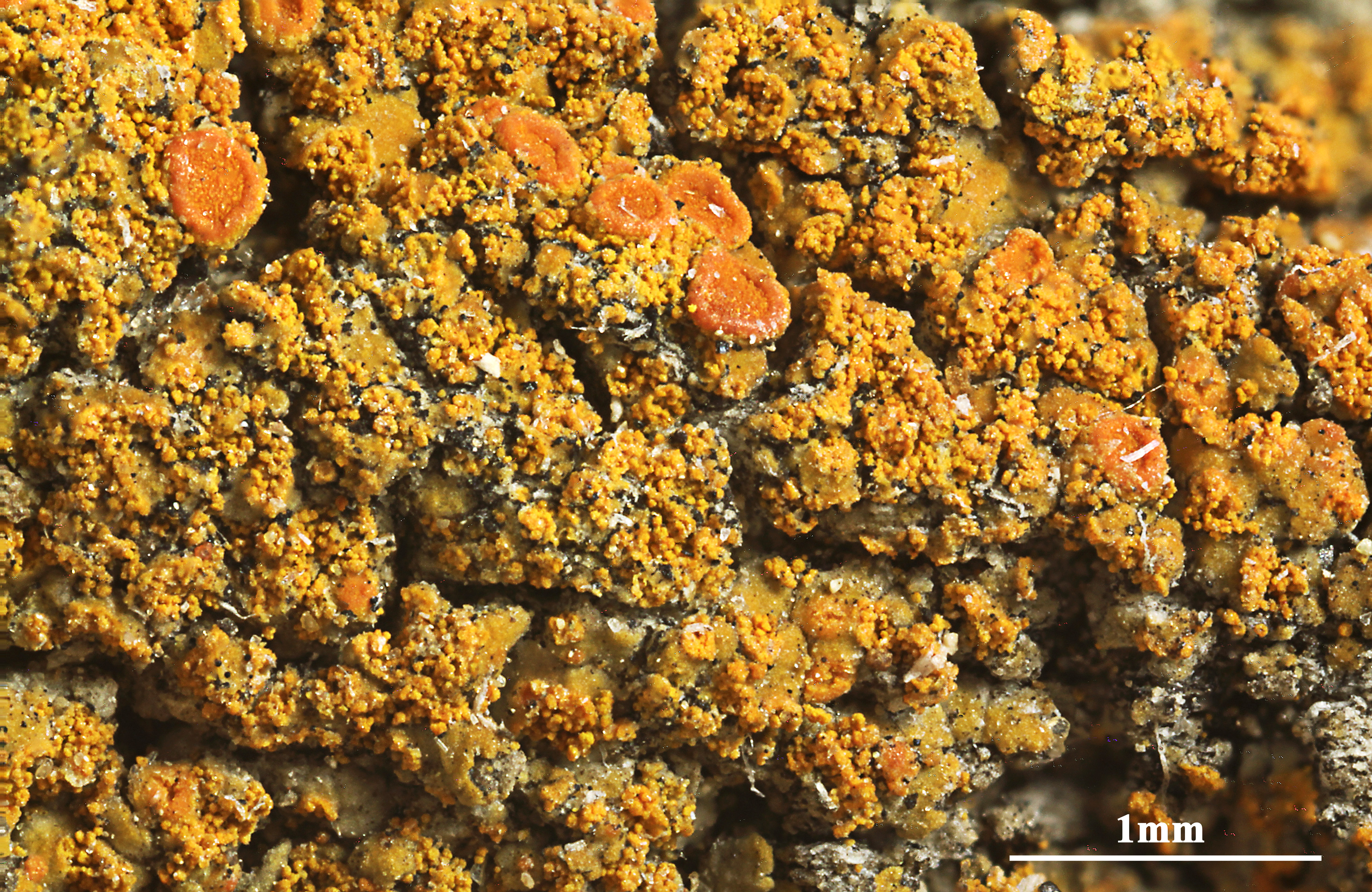
Felix Schumm - CC BY-SA 4.0
[19404], USA, Nebraska, Scotts Bluff Co., Scotts Bluff National Monument, on top of bluff in ponderosa pine (Pinus ponderosa) area, 1403 m, 41°15'17'' N, 103°42'04'' W, on pine snag. Leg. C. M. Wetmore (No. 77577), 2. July 1997. TELOSCHIST. EXS. NO. 111
P.L. Nimis; Owner: Department of Life Sciences, University of Trieste
Herbarium: TSB (13321)
2001/11/13
P.L. Nimis; Owner: Department of Life Sciences, University of Trieste
Herbarium: TSB (13321)
2001/11/13
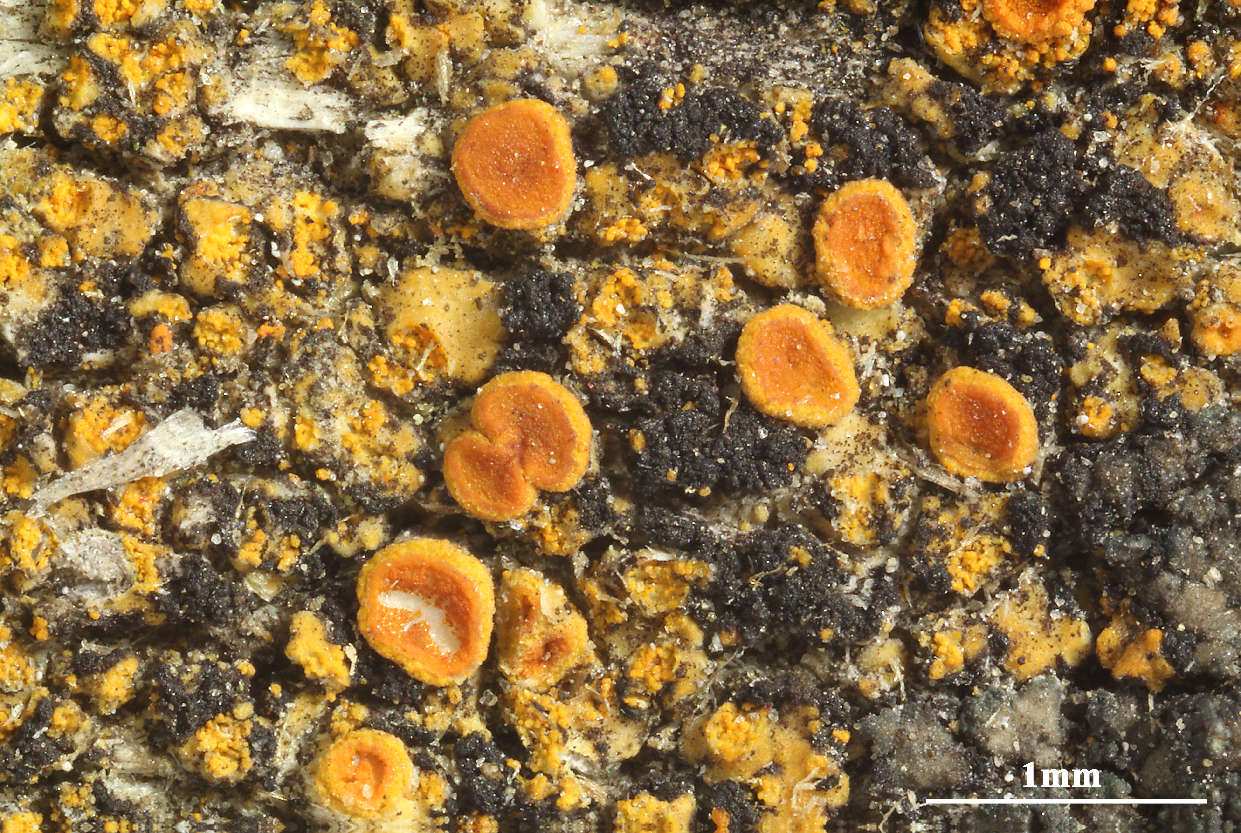
Felix Schumm - CC BY-SA 4.0
[19404], USA, Nebraska, Scotts Bluff Co., Scotts Bluff National Monument, on top of bluff in ponderosa pine (Pinus ponderosa) area, 1403 m, 41°15'17'' N, 103°42'04'' W, on pine snag. Leg. C. M. Wetmore (No. 77577), 2. July 1997. TELOSCHIST. EXS. NO. 111
Felix Schumm - CC BY-SA 4.0
[19404], USA, Nebraska, Scotts Bluff Co., Scotts Bluff National Monument, on top of bluff in ponderosa pine (Pinus ponderosa) area, 1403 m, 41°15'17'' N, 103°42'04'' W, on pine snag. Leg. C. M. Wetmore (No. 77577), 2. July 1997. TELOSCHIST. EXS. NO. 111
Felix Schumm - CC BY-SA 4.0
[19404], USA, Nebraska, Scotts Bluff Co., Scotts Bluff National Monument, on top of bluff in ponderosa pine (Pinus ponderosa) area, 1403 m, 41°15'17'' N, 103°42'04'' W, on pine snag. Leg. C. M. Wetmore (No. 77577), 2. July 1997. TELOSCHIST. EXS. NO. 111
Felix Schumm - CC BY-SA 4.0
[19404], USA, Nebraska, Scotts Bluff Co., Scotts Bluff National Monument, on top of bluff in ponderosa pine (Pinus ponderosa) area, 1403 m, 41°15'17'' N, 103°42'04'' W, on pine snag. Leg. C. M. Wetmore (No. 77577), 2. July 1997. TELOSCHIST. EXS. NO. 111
Felix Schumm - CC BY-SA 4.0
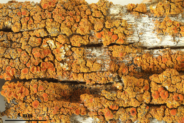
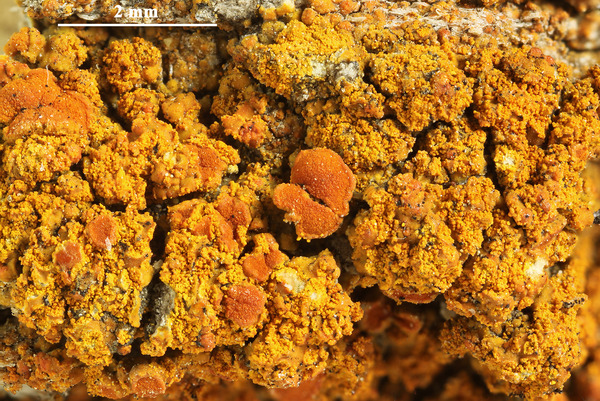
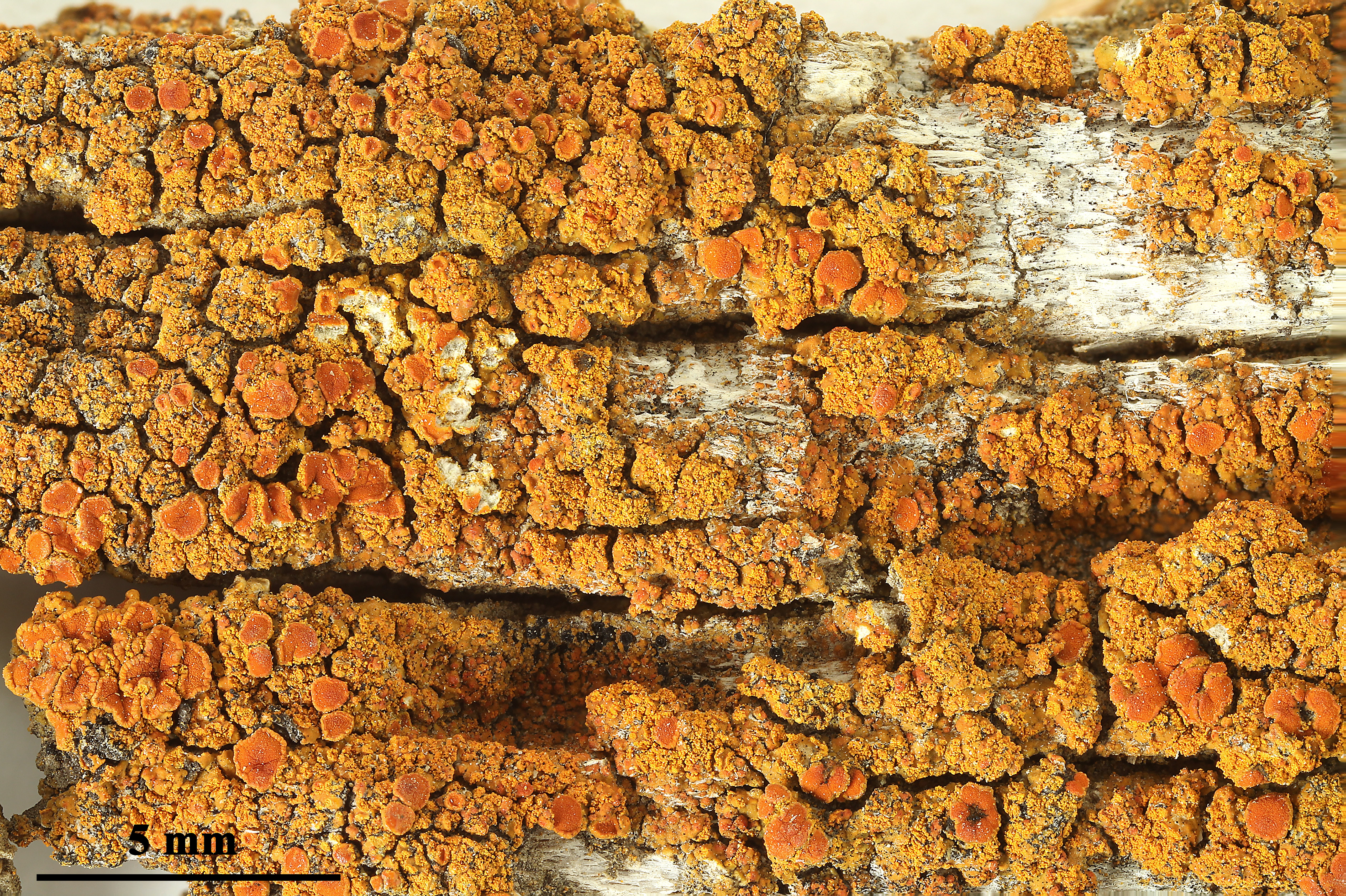
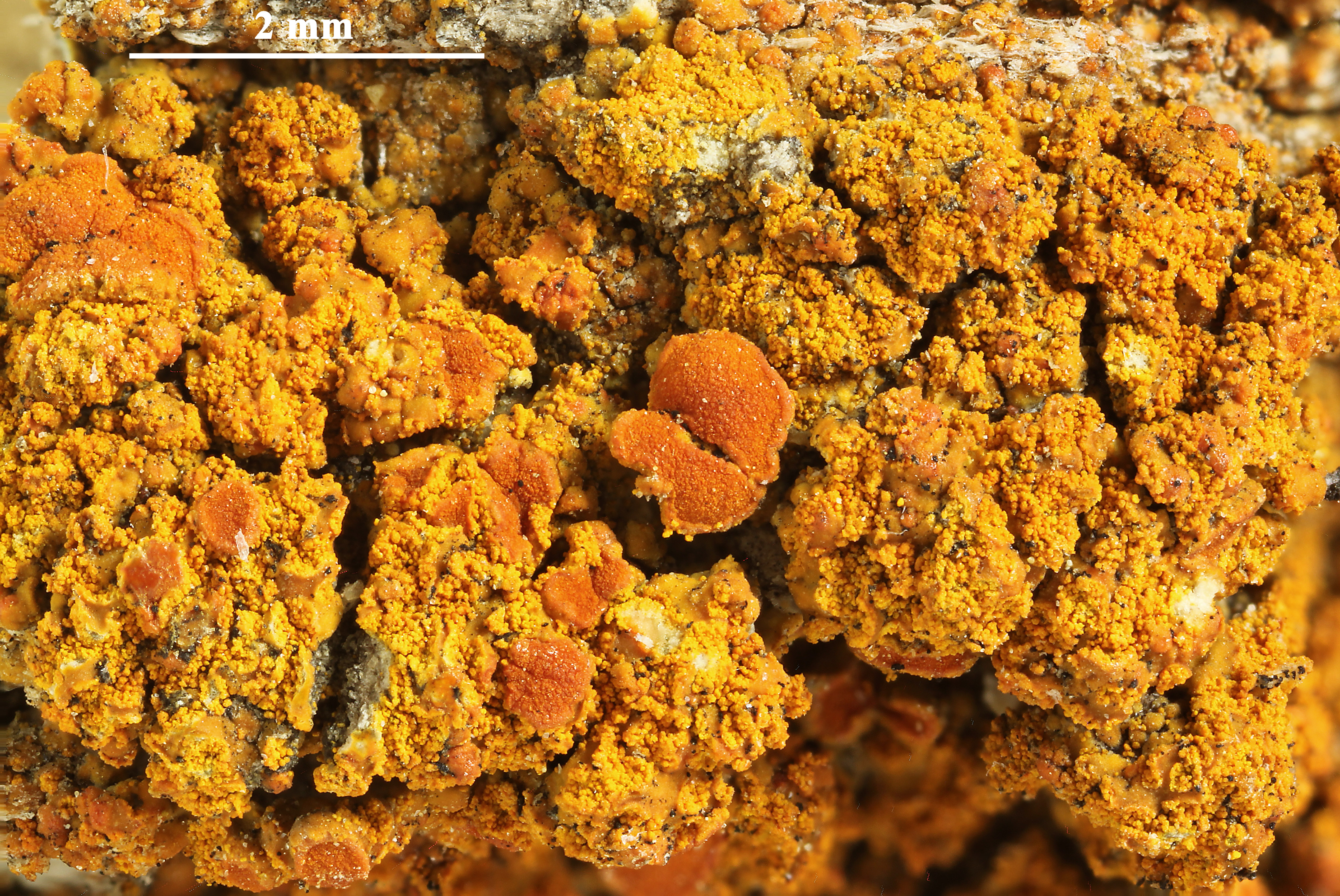
[BR5030110037363V], USA, Minnesota, Clay Co: ca 3 mi E & 2 mi S of Glyndon, the Nature Conservancy’s Bluestern Prairie Preserve. 46°50.78’ M, 96°28.61’ W, 925 ft. On wooden shingles. Leg. M.K. Advaita (6629), 9. May 2008. LICH. EXS. MAGNICAMPORUM NO. 35
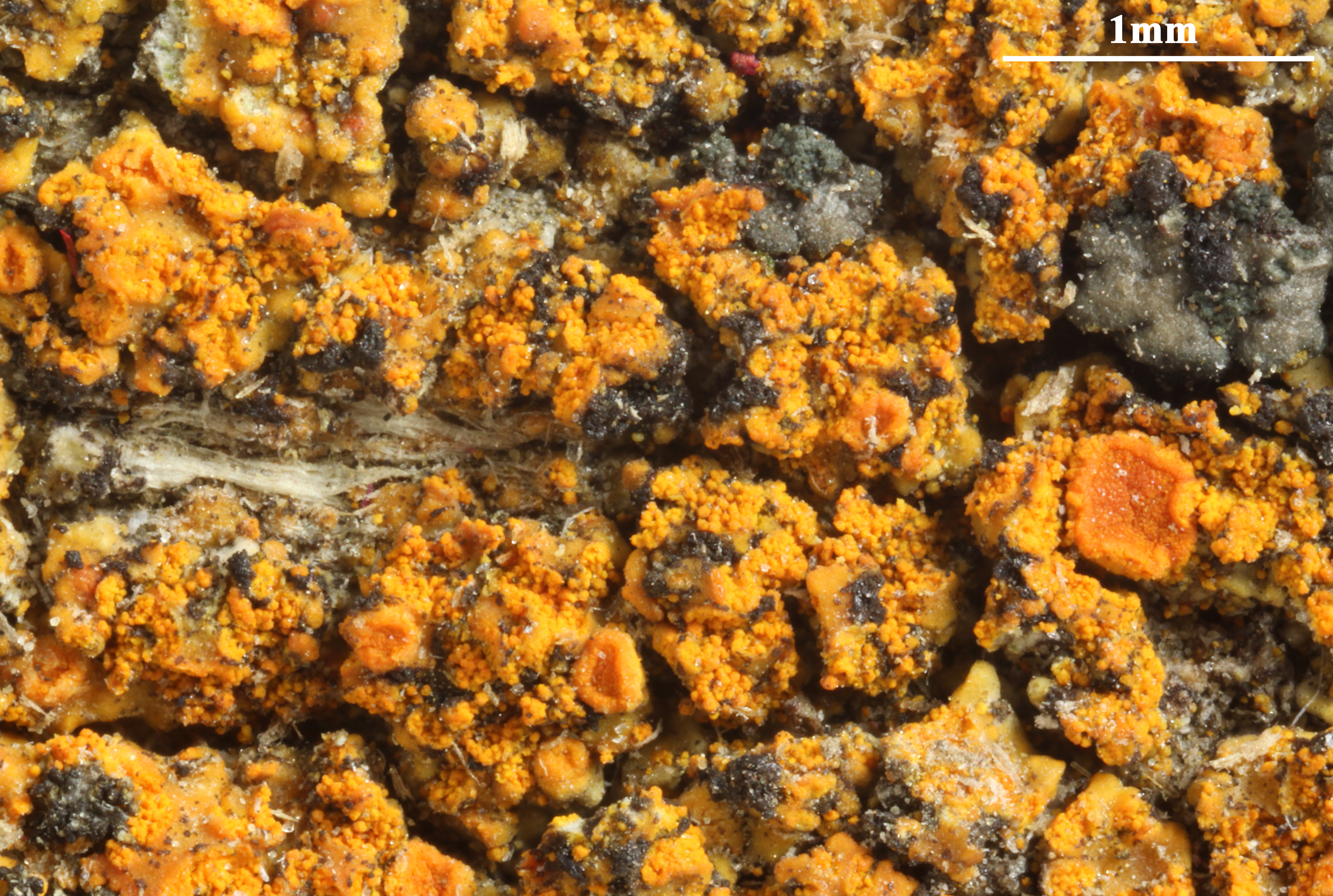
Felix Schumm - CC BY-SA 4.0
[BR5030110037363V], USA, Minnesota, Clay Co: ca 3 mi E & 2 mi S of Glyndon, the Nature Conservancy’s Bluestern Prairie Preserve. 46°50.78’ M, 96°28.61’ W, 925 ft. On wooden shingles. Leg. M.K. Advaita (6629), 9. May 2008. LICH. EXS. MAGNICAMPORUM NO. 35

Felix Schumm - CC BY-SA 4.0
[BR5030110037363V], USA, Minnesota, Clay Co: ca 3 mi E & 2 mi S of Glyndon, the Nature Conservancy’s Bluestern Prairie Preserve. 46°50.78’ M, 96°28.61’ W, 925 ft. On wooden shingles. Leg. M.K. Advaita (6629), 9. May 2008. LICH. EXS. MAGNICAMPORUM NO. 35

Felix Schumm - CC BY-SA 4.0
[BR5030110037363V], USA, Minnesota, Clay Co: ca 3 mi E & 2 mi S of Glyndon, the Nature Conservancy’s Bluestern Prairie Preserve. 46°50.78’ M, 96°28.61’ W, 925 ft. On wooden shingles. Leg. M.K. Advaita (6629), 9. May 2008. LICH. EXS. MAGNICAMPORUM NO. 35

Felix Schumm - CC BY-SA 4.0
[BR5030110037363V], USA, Minnesota, Clay Co: ca 3 mi E & 2 mi S of Glyndon, the Nature Conservancy’s Bluestern Prairie Preserve. 46°50.78’ M, 96°28.61’ W, 925 ft. On wooden shingles. Leg. M.K. Advaita (6629), 9. May 2008. LICH. EXS. MAGNICAMPORUM NO. 35
Felix Schumm - CC BY-SA 4.0
[BR5030110037363V], USA, Minnesota, Clay Co: ca 3 mi E & 2 mi S of Glyndon, the Nature Conservancy’s Bluestern Prairie Preserve. 46°50.78’ M, 96°28.61’ W, 925 ft. On wooden shingles. Leg. M.K. Advaita (6629), 9. May 2008. LICH. EXS. MAGNICAMPORUM NO. 35
Felix Schumm - CC BY-SA 4.0
[BR5030110037363V], USA, Minnesota, Clay Co: ca 3 mi E & 2 mi S of Glyndon, the Nature Conservancy’s Bluestern Prairie Preserve. 46°50.78’ M, 96°28.61’ W, 925 ft. On wooden shingles. Leg. M.K. Advaita (6629), 9. May 2008. LICH. EXS. MAGNICAMPORUM NO. 35

Felix Schumm - CC BY-SA 4.0
[BR5030110037363V], USA, Minnesota, Clay Co: ca 3 mi E & 2 mi S of Glyndon, the Nature Conservancy’s Bluestern Prairie Preserve. 46°50.78’ M, 96°28.61’ W, 925 ft. On wooden shingles. Leg. M.K. Advaita (6629), 9. May 2008. LICH. EXS. MAGNICAMPORUM NO. 35
Felix Schumm - CC BY-SA 4.0
[BR5030110037363V], USA, Minnesota, Clay Co: ca 3 mi E & 2 mi S of Glyndon, the Nature Conservancy’s Bluestern Prairie Preserve. 46°50.78’ M, 96°28.61’ W, 925 ft. On wooden shingles. Leg. M.K. Advaita (6629), 9. May 2008. LICH. EXS. MAGNICAMPORUM NO. 35

Felix Schumm - CC BY-SA 4.0
[BR5030110037363V], USA, Minnesota, Clay Co: ca 3 mi E & 2 mi S of Glyndon, the Nature Conservancy’s Bluestern Prairie Preserve. 46°50.78’ M, 96°28.61’ W, 925 ft. On wooden shingles. Leg. M.K. Advaita (6629), 9. May 2008. LICH. EXS. MAGNICAMPORUM NO. 35

Felix Schumm - CC BY-SA 4.0
[BR5030110037363V], USA, Minnesota, Clay Co: ca 3 mi E & 2 mi S of Glyndon, the Nature Conservancy’s Bluestern Prairie Preserve. 46°50.78’ M, 96°28.61’ W, 925 ft. On wooden shingles. Leg. M.K. Advaita (6629), 9. May 2008. LICH. EXS. MAGNICAMPORUM NO. 35

Felix Schumm - CC BY-SA 4.0
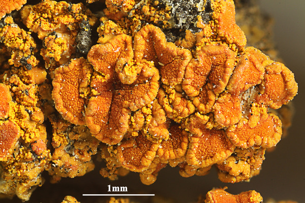
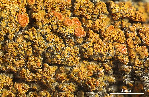
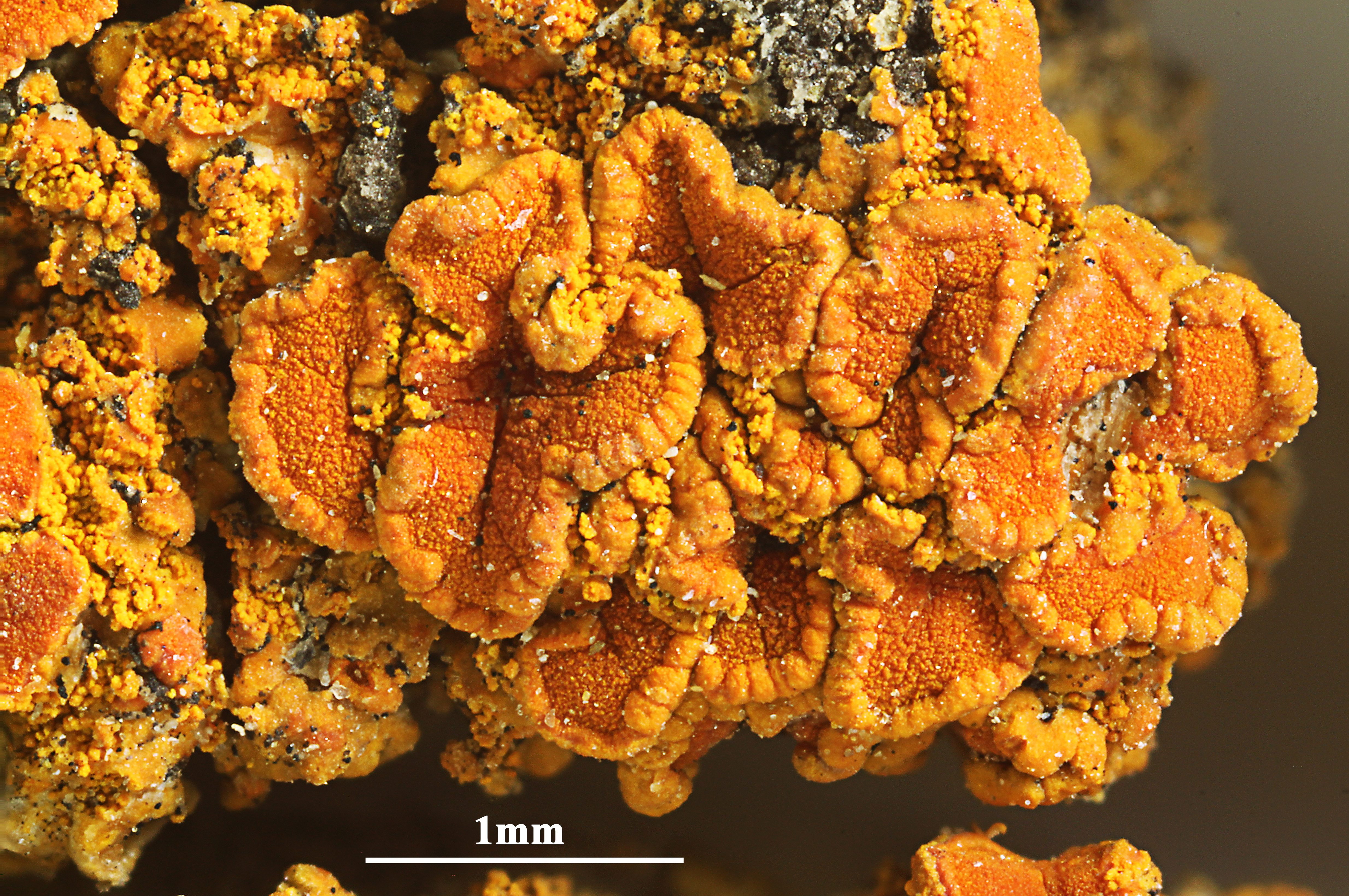
[BR5030038241231], USA, California, Joshuattree National Monument, on Juniperus californica. 33°58’ N, 116°04’ W, 1200 m. Leg. C. M. van Herk, 14.04.1995, det. A. Aptroot 1995.
Felix Schumm - CC BY-SA 4.0
[BR5030038241231], USA, California, Joshuattree National Monument, on Juniperus californica. 33°58’ N, 116°04’ W, 1200 m. Leg. C. M. van Herk, 14.04.1995, det. A. Aptroot 1995.
Felix Schumm - CC BY-SA 4.0
[BR5030038241231], USA, California, Joshuattree National Monument, on Juniperus californica. 33°58’ N, 116°04’ W, 1200 m. Leg. C. M. van Herk, 14.04.1995, det. A. Aptroot 1995.

Felix Schumm - CC BY-SA 4.0
[BR5030038241231], USA, California, Joshuattree National Monument, on Juniperus californica. 33°58’ N, 116°04’ W, 1200 m. Leg. C. M. van Herk, 14.04.1995, det. A. Aptroot 1995.
Felix Schumm - CC BY-SA 4.0
[BR5030038241231], USA, California, Joshuattree National Monument, on Juniperus californica. 33°58’ N, 116°04’ W, 1200 m. Leg. C. M. van Herk, 14.04.1995, det. A. Aptroot 1995.
Felix Schumm - CC BY-SA 4.0
[BR5030038241231], USA, California, Joshuattree National Monument, on Juniperus californica. 33°58’ N, 116°04’ W, 1200 m. Leg. C. M. van Herk, 14.04.1995, det. A. Aptroot 1995.
Felix Schumm - CC BY-SA 4.0
[BR5030038241231], USA, California, Joshuattree National Monument, on Juniperus californica. 33°58’ N, 116°04’ W, 1200 m. Leg. C. M. van Herk, 14.04.1995, det. A. Aptroot 1995.
Felix Schumm - CC BY-SA 4.0
[BR5030038241231], USA, California, Joshuattree National Monument, on Juniperus californica. 33°58’ N, 116°04’ W, 1200 m. Leg. C. M. van Herk, 14.04.1995, det. A. Aptroot 1995.
Felix Schumm - CC BY-SA 4.0
[BR5030038241231], USA, California, Joshuattree National Monument, on Juniperus californica. 33°58’ N, 116°04’ W, 1200 m. Leg. C. M. van Herk, 14.04.1995, det. A. Aptroot 1995.
Felix Schumm - CC BY-SA 4.0
[BR5030038241231], USA, California, Joshuattree National Monument, on Juniperus californica. 33°58’ N, 116°04’ W, 1200 m. Leg. C. M. van Herk, 14.04.1995, det. A. Aptroot 1995.

Felix Schumm - CC BY-SA 4.0
[BR5030038241231], USA, California, Joshuattree National Monument, on Juniperus californica. 33°58’ N, 116°04’ W, 1200 m. Leg. C. M. van Herk, 14.04.1995, det. A. Aptroot 1995.

Felix Schumm - CC BY-SA 4.0
[BR5030038241231], USA, California, Joshuattree National Monument, on Juniperus californica. 33°58’ N, 116°04’ W, 1200 m. Leg. C. M. van Herk, 14.04.1995, det. A. Aptroot 1995.
Felix Schumm - CC BY-SA 4.0
[BR5030038241231], USA, California, Joshuattree National Monument, on Juniperus californica. 33°58’ N, 116°04’ W, 1200 m. Leg. C. M. van Herk, 14.04.1995, det. A. Aptroot 1995.

Felix Schumm - CC BY-SA 4.0
[BR5030038241231], USA, California, Joshuattree National Monument, on Juniperus californica. 33°58’ N, 116°04’ W, 1200 m. Leg. C. M. van Herk, 14.04.1995, det. A. Aptroot 1995.
Felix Schumm - CC BY-SA 4.0
[BR5030038241231], USA, California, Joshuattree National Monument, on Juniperus californica. 33°58’ N, 116°04’ W, 1200 m. Leg. C. M. van Herk, 14.04.1995, det. A. Aptroot 1995.

Felix Schumm - CC BY-SA 4.0
[BR5030038241231], USA, California, Joshuattree National Monument, on Juniperus californica. 33°58’ N, 116°04’ W, 1200 m. Leg. C. M. van Herk, 14.04.1995, det. A. Aptroot 1995.

Felix Schumm - CC BY-SA 4.0
[BR5030038241231], USA, California, Joshuattree National Monument, on Juniperus californica. 33°58’ N, 116°04’ W, 1200 m. Leg. C. M. van Herk, 14.04.1995, det. A. Aptroot 1995.

Felix Schumm - CC BY-SA 4.0
[BR5030038241231], USA, California, Joshuattree National Monument, on Juniperus californica. 33°58’ N, 116°04’ W, 1200 m. Leg. C. M. van Herk, 14.04.1995, det. A. Aptroot 1995.
Felix Schumm - CC BY-SA 4.0
[BR5030038241231], USA, California, Joshuattree National Monument, on Juniperus californica. 33°58’ N, 116°04’ W, 1200 m. Leg. C. M. van Herk, 14.04.1995, det. A. Aptroot 1995.
Felix Schumm - CC BY-SA 4.0
[BR5030038241231], USA, California, Joshuattree National Monument, on Juniperus californica. 33°58’ N, 116°04’ W, 1200 m. Leg. C. M. van Herk, 14.04.1995, det. A. Aptroot 1995.
Felix Schumm - CC BY-SA 4.0
[BR5030038241231], USA, California, Joshuattree National Monument, on Juniperus californica. 33°58’ N, 116°04’ W, 1200 m. Leg. C. M. van Herk, 14.04.1995, det. A. Aptroot 1995.
Felix Schumm - CC BY-SA 4.0
[BR5030038241231], USA, California, Joshuattree National Monument, on Juniperus californica. 33°58’ N, 116°04’ W, 1200 m. Leg. C. M. van Herk, 14.04.1995, det. A. Aptroot 1995.
Felix Schumm - CC BY-SA 4.0
[BR5030038241231], USA, California, Joshuattree National Monument, on Juniperus californica. 33°58’ N, 116°04’ W, 1200 m. Leg. C. M. van Herk, 14.04.1995, det. A. Aptroot 1995.
Felix Schumm - CC BY-SA 4.0
[BR5030038241231], USA, California, Joshuattree National Monument, on Juniperus californica. 33°58’ N, 116°04’ W, 1200 m. Leg. C. M. van Herk, 14.04.1995, det. A. Aptroot 1995.

Felix Schumm - CC BY-SA 4.0
[BR5030038241231], USA, California, Joshuattree National Monument, on Juniperus californica. 33°58’ N, 116°04’ W, 1200 m. Leg. C. M. van Herk, 14.04.1995, det. A. Aptroot 1995.
Growth form: Crustose
Substrata: bark and lignum
Photobiont: green algae other than Trentepohlia
Reproductive strategy: mainly asexual, by soredia, or soredia-like structures (e.g. blastidia)
Subcontinental: restricted to areas with a dry-subcontinental climate (e.g. dry Alpine valleys, parts of Mediterranean Italy)
Commonnes-rarity: (info)
Alpine belt: absent
Subalpine belt: absent
Oromediterranean belt: absent
Montane belt: extremely rare
Submediterranean belt: extremely rare
Padanian area: absent
Humid submediterranean belt: absent
Humid mediterranean belt: absent
Dry mediterranean belt: absent
Predictive model
| Herbarium samples |

Felix Schumm - CC BY-SA 4.0
[19404], USA, Nebraska, Scotts Bluff Co., Scotts Bluff National Monument, on top of bluff in ponderosa pine (Pinus ponderosa) area, 1403 m, 41°15'17'' N, 103°42'04'' W, on pine snag. Leg. C. M. Wetmore (No. 77577), 2. July 1997. TELOSCHIST. EXS. NO. 111

P.L. Nimis; Owner: Department of Life Sciences, University of Trieste
Herbarium: TSB (13321)
2001/11/13
P.L. Nimis; Owner: Department of Life Sciences, University of Trieste
Herbarium: TSB (13321)
2001/11/13
Felix Schumm - CC BY-SA 4.0
[19404], USA, Nebraska, Scotts Bluff Co., Scotts Bluff National Monument, on top of bluff in ponderosa pine (Pinus ponderosa) area, 1403 m, 41°15'17'' N, 103°42'04'' W, on pine snag. Leg. C. M. Wetmore (No. 77577), 2. July 1997. TELOSCHIST. EXS. NO. 111
Felix Schumm - CC BY-SA 4.0
[19404], USA, Nebraska, Scotts Bluff Co., Scotts Bluff National Monument, on top of bluff in ponderosa pine (Pinus ponderosa) area, 1403 m, 41°15'17'' N, 103°42'04'' W, on pine snag. Leg. C. M. Wetmore (No. 77577), 2. July 1997. TELOSCHIST. EXS. NO. 111
Felix Schumm - CC BY-SA 4.0
[19404], USA, Nebraska, Scotts Bluff Co., Scotts Bluff National Monument, on top of bluff in ponderosa pine (Pinus ponderosa) area, 1403 m, 41°15'17'' N, 103°42'04'' W, on pine snag. Leg. C. M. Wetmore (No. 77577), 2. July 1997. TELOSCHIST. EXS. NO. 111
Felix Schumm - CC BY-SA 4.0
[19404], USA, Nebraska, Scotts Bluff Co., Scotts Bluff National Monument, on top of bluff in ponderosa pine (Pinus ponderosa) area, 1403 m, 41°15'17'' N, 103°42'04'' W, on pine snag. Leg. C. M. Wetmore (No. 77577), 2. July 1997. TELOSCHIST. EXS. NO. 111

Felix Schumm - CC BY-SA 4.0
[BR5030110037363V], USA, Minnesota, Clay Co: ca 3 mi E & 2 mi S of Glyndon, the Nature Conservancy’s Bluestern Prairie Preserve. 46°50.78’ M, 96°28.61’ W, 925 ft. On wooden shingles. Leg. M.K. Advaita (6629), 9. May 2008. LICH. EXS. MAGNICAMPORUM NO. 35

Felix Schumm - CC BY-SA 4.0
[BR5030110037363V], USA, Minnesota, Clay Co: ca 3 mi E & 2 mi S of Glyndon, the Nature Conservancy’s Bluestern Prairie Preserve. 46°50.78’ M, 96°28.61’ W, 925 ft. On wooden shingles. Leg. M.K. Advaita (6629), 9. May 2008. LICH. EXS. MAGNICAMPORUM NO. 35
Felix Schumm - CC BY-SA 4.0
[BR5030110037363V], USA, Minnesota, Clay Co: ca 3 mi E & 2 mi S of Glyndon, the Nature Conservancy’s Bluestern Prairie Preserve. 46°50.78’ M, 96°28.61’ W, 925 ft. On wooden shingles. Leg. M.K. Advaita (6629), 9. May 2008. LICH. EXS. MAGNICAMPORUM NO. 35
Felix Schumm - CC BY-SA 4.0
[BR5030110037363V], USA, Minnesota, Clay Co: ca 3 mi E & 2 mi S of Glyndon, the Nature Conservancy’s Bluestern Prairie Preserve. 46°50.78’ M, 96°28.61’ W, 925 ft. On wooden shingles. Leg. M.K. Advaita (6629), 9. May 2008. LICH. EXS. MAGNICAMPORUM NO. 35
Felix Schumm - CC BY-SA 4.0
[BR5030110037363V], USA, Minnesota, Clay Co: ca 3 mi E & 2 mi S of Glyndon, the Nature Conservancy’s Bluestern Prairie Preserve. 46°50.78’ M, 96°28.61’ W, 925 ft. On wooden shingles. Leg. M.K. Advaita (6629), 9. May 2008. LICH. EXS. MAGNICAMPORUM NO. 35
Felix Schumm - CC BY-SA 4.0
[BR5030110037363V], USA, Minnesota, Clay Co: ca 3 mi E & 2 mi S of Glyndon, the Nature Conservancy’s Bluestern Prairie Preserve. 46°50.78’ M, 96°28.61’ W, 925 ft. On wooden shingles. Leg. M.K. Advaita (6629), 9. May 2008. LICH. EXS. MAGNICAMPORUM NO. 35

Felix Schumm - CC BY-SA 4.0
[BR5030110037363V], USA, Minnesota, Clay Co: ca 3 mi E & 2 mi S of Glyndon, the Nature Conservancy’s Bluestern Prairie Preserve. 46°50.78’ M, 96°28.61’ W, 925 ft. On wooden shingles. Leg. M.K. Advaita (6629), 9. May 2008. LICH. EXS. MAGNICAMPORUM NO. 35
Felix Schumm - CC BY-SA 4.0
[BR5030110037363V], USA, Minnesota, Clay Co: ca 3 mi E & 2 mi S of Glyndon, the Nature Conservancy’s Bluestern Prairie Preserve. 46°50.78’ M, 96°28.61’ W, 925 ft. On wooden shingles. Leg. M.K. Advaita (6629), 9. May 2008. LICH. EXS. MAGNICAMPORUM NO. 35

Felix Schumm - CC BY-SA 4.0
[BR5030110037363V], USA, Minnesota, Clay Co: ca 3 mi E & 2 mi S of Glyndon, the Nature Conservancy’s Bluestern Prairie Preserve. 46°50.78’ M, 96°28.61’ W, 925 ft. On wooden shingles. Leg. M.K. Advaita (6629), 9. May 2008. LICH. EXS. MAGNICAMPORUM NO. 35
Felix Schumm - CC BY-SA 4.0
[BR5030110037363V], USA, Minnesota, Clay Co: ca 3 mi E & 2 mi S of Glyndon, the Nature Conservancy’s Bluestern Prairie Preserve. 46°50.78’ M, 96°28.61’ W, 925 ft. On wooden shingles. Leg. M.K. Advaita (6629), 9. May 2008. LICH. EXS. MAGNICAMPORUM NO. 35
Felix Schumm - CC BY-SA 4.0
[BR5030110037363V], USA, Minnesota, Clay Co: ca 3 mi E & 2 mi S of Glyndon, the Nature Conservancy’s Bluestern Prairie Preserve. 46°50.78’ M, 96°28.61’ W, 925 ft. On wooden shingles. Leg. M.K. Advaita (6629), 9. May 2008. LICH. EXS. MAGNICAMPORUM NO. 35
Felix Schumm - CC BY-SA 4.0
[BR5030038241231], USA, California, Joshuattree National Monument, on Juniperus californica. 33°58’ N, 116°04’ W, 1200 m. Leg. C. M. van Herk, 14.04.1995, det. A. Aptroot 1995.

Felix Schumm - CC BY-SA 4.0
[BR5030038241231], USA, California, Joshuattree National Monument, on Juniperus californica. 33°58’ N, 116°04’ W, 1200 m. Leg. C. M. van Herk, 14.04.1995, det. A. Aptroot 1995.

Felix Schumm - CC BY-SA 4.0
[BR5030038241231], USA, California, Joshuattree National Monument, on Juniperus californica. 33°58’ N, 116°04’ W, 1200 m. Leg. C. M. van Herk, 14.04.1995, det. A. Aptroot 1995.
Felix Schumm - CC BY-SA 4.0
[BR5030038241231], USA, California, Joshuattree National Monument, on Juniperus californica. 33°58’ N, 116°04’ W, 1200 m. Leg. C. M. van Herk, 14.04.1995, det. A. Aptroot 1995.
Felix Schumm - CC BY-SA 4.0
[BR5030038241231], USA, California, Joshuattree National Monument, on Juniperus californica. 33°58’ N, 116°04’ W, 1200 m. Leg. C. M. van Herk, 14.04.1995, det. A. Aptroot 1995.
Felix Schumm - CC BY-SA 4.0
[BR5030038241231], USA, California, Joshuattree National Monument, on Juniperus californica. 33°58’ N, 116°04’ W, 1200 m. Leg. C. M. van Herk, 14.04.1995, det. A. Aptroot 1995.
Felix Schumm - CC BY-SA 4.0
[BR5030038241231], USA, California, Joshuattree National Monument, on Juniperus californica. 33°58’ N, 116°04’ W, 1200 m. Leg. C. M. van Herk, 14.04.1995, det. A. Aptroot 1995.

Felix Schumm - CC BY-SA 4.0
[BR5030038241231], USA, California, Joshuattree National Monument, on Juniperus californica. 33°58’ N, 116°04’ W, 1200 m. Leg. C. M. van Herk, 14.04.1995, det. A. Aptroot 1995.

Felix Schumm - CC BY-SA 4.0
[BR5030038241231], USA, California, Joshuattree National Monument, on Juniperus californica. 33°58’ N, 116°04’ W, 1200 m. Leg. C. M. van Herk, 14.04.1995, det. A. Aptroot 1995.

Felix Schumm - CC BY-SA 4.0
[BR5030038241231], USA, California, Joshuattree National Monument, on Juniperus californica. 33°58’ N, 116°04’ W, 1200 m. Leg. C. M. van Herk, 14.04.1995, det. A. Aptroot 1995.
Felix Schumm - CC BY-SA 4.0
[BR5030038241231], USA, California, Joshuattree National Monument, on Juniperus californica. 33°58’ N, 116°04’ W, 1200 m. Leg. C. M. van Herk, 14.04.1995, det. A. Aptroot 1995.
Felix Schumm - CC BY-SA 4.0
[BR5030038241231], USA, California, Joshuattree National Monument, on Juniperus californica. 33°58’ N, 116°04’ W, 1200 m. Leg. C. M. van Herk, 14.04.1995, det. A. Aptroot 1995.

Felix Schumm - CC BY-SA 4.0
[BR5030038241231], USA, California, Joshuattree National Monument, on Juniperus californica. 33°58’ N, 116°04’ W, 1200 m. Leg. C. M. van Herk, 14.04.1995, det. A. Aptroot 1995.
Felix Schumm - CC BY-SA 4.0
[BR5030038241231], USA, California, Joshuattree National Monument, on Juniperus californica. 33°58’ N, 116°04’ W, 1200 m. Leg. C. M. van Herk, 14.04.1995, det. A. Aptroot 1995.
Felix Schumm - CC BY-SA 4.0
[BR5030038241231], USA, California, Joshuattree National Monument, on Juniperus californica. 33°58’ N, 116°04’ W, 1200 m. Leg. C. M. van Herk, 14.04.1995, det. A. Aptroot 1995.
Felix Schumm - CC BY-SA 4.0
[BR5030038241231], USA, California, Joshuattree National Monument, on Juniperus californica. 33°58’ N, 116°04’ W, 1200 m. Leg. C. M. van Herk, 14.04.1995, det. A. Aptroot 1995.
Felix Schumm - CC BY-SA 4.0
[BR5030038241231], USA, California, Joshuattree National Monument, on Juniperus californica. 33°58’ N, 116°04’ W, 1200 m. Leg. C. M. van Herk, 14.04.1995, det. A. Aptroot 1995.
Felix Schumm - CC BY-SA 4.0
[BR5030038241231], USA, California, Joshuattree National Monument, on Juniperus californica. 33°58’ N, 116°04’ W, 1200 m. Leg. C. M. van Herk, 14.04.1995, det. A. Aptroot 1995.

Felix Schumm - CC BY-SA 4.0
[BR5030038241231], USA, California, Joshuattree National Monument, on Juniperus californica. 33°58’ N, 116°04’ W, 1200 m. Leg. C. M. van Herk, 14.04.1995, det. A. Aptroot 1995.
Felix Schumm - CC BY-SA 4.0
[BR5030038241231], USA, California, Joshuattree National Monument, on Juniperus californica. 33°58’ N, 116°04’ W, 1200 m. Leg. C. M. van Herk, 14.04.1995, det. A. Aptroot 1995.
Felix Schumm - CC BY-SA 4.0
[BR5030038241231], USA, California, Joshuattree National Monument, on Juniperus californica. 33°58’ N, 116°04’ W, 1200 m. Leg. C. M. van Herk, 14.04.1995, det. A. Aptroot 1995.

Felix Schumm - CC BY-SA 4.0
[BR5030038241231], USA, California, Joshuattree National Monument, on Juniperus californica. 33°58’ N, 116°04’ W, 1200 m. Leg. C. M. van Herk, 14.04.1995, det. A. Aptroot 1995.

Felix Schumm - CC BY-SA 4.0
[BR5030038241231], USA, California, Joshuattree National Monument, on Juniperus californica. 33°58’ N, 116°04’ W, 1200 m. Leg. C. M. van Herk, 14.04.1995, det. A. Aptroot 1995.

Felix Schumm - CC BY-SA 4.0
[BR5030038241231], USA, California, Joshuattree National Monument, on Juniperus californica. 33°58’ N, 116°04’ W, 1200 m. Leg. C. M. van Herk, 14.04.1995, det. A. Aptroot 1995.