Ramalina thrausta (Ach.) Nyl.
Syn. Lich., 1: 296, 1860. Basionym: Alectoria thrausta Ach. - Lichenogr. Univ.: 596, 1810.
Synonyms: Alectoria crinalis Ach.; Alectoria sarmentosa var. crinalis (Ach.) H. Olivier; Ramalina crinalis (Ach.) Gyeln.; Ramalina thrausta f. sorediosula Nyl.
Distribution: N - Frl (Nascimbene & al. 1998), Ven (Nascimbene & Caniglia 2000b, 2003c, Nascimbene 2003b, 2011, Nascimbene & al. 2009c, Ravera & al. 2022), TAA (Nascimbene 2006b, 2008c, 2014, Nascimbene & al. 2006e, 2007b, 2009, 2010, 2014, 2022, Nascimbene & Marini 2015, Nimis & al. 2015, Trindade & al. 2021), VA (GDOR 1311). C - Tosc (Benesperi & al. 2007), Sar. S - Pugl (Nimis & Tretiach 1999), Si.
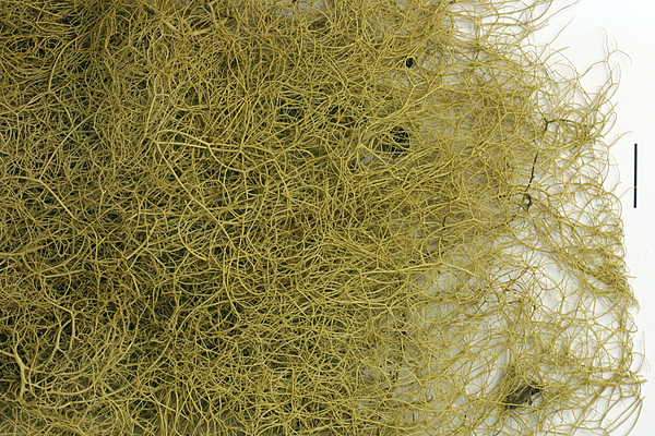
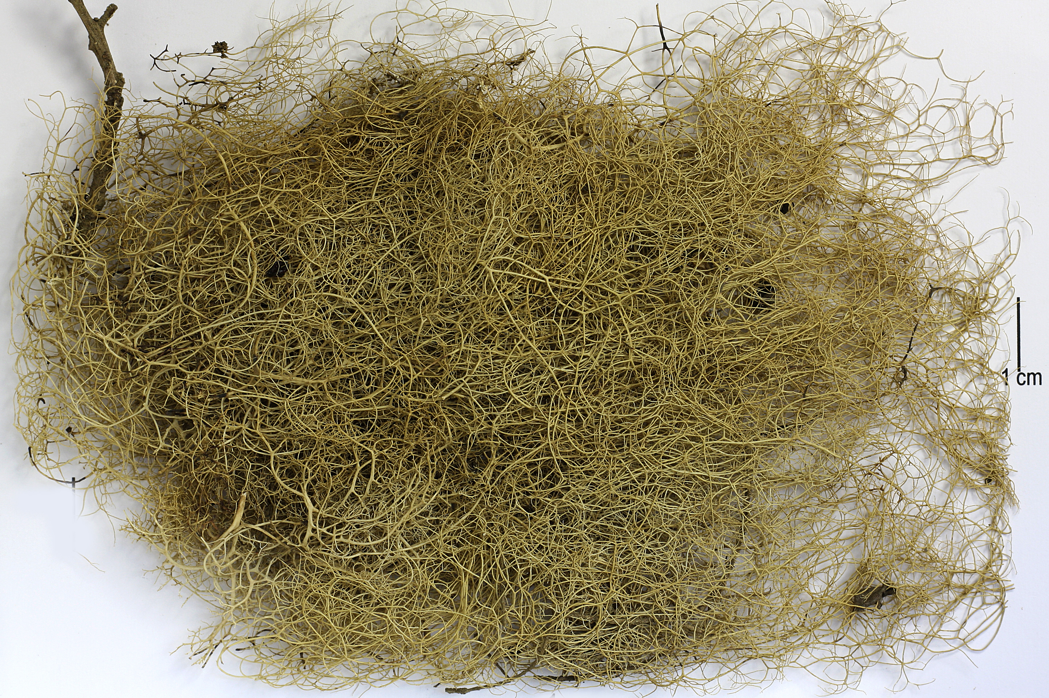
Description: Thallus fruticose, filamentous, long-pendent, up to 40 cm long, pale green. Branches thread-like, mostly <0.5(-1) mm in diam. Main branches interwoven, terete, widely divergent or nearly contiguous, the apical branches very thin, the tips often hooked or curled, ending in a minute punctiform soralium. Cortex smooth, even, glossy, pale green, rarely with a few minute, oval pseudocyphellae; medulla white loose, arachnoid. Apothecia never observed in Italian material. Photobiont chlorococcoid. Spot tests: cortex and medulla K-, C-, KC-, P-, UV-. Chemistry: cortex with usnic acid, medulla with perlatolic acid (minor) and stenosporic acid (minor or major).Note: a cool-temperate to southern boreal lichen found on branches and twigs of conifers and deciduous trees in montane forests with frequent fog, occasionally lignicolous and saxicolous; rare and probably declining throughout Italy.
Growth form: Fruticose
Substrata: bark
Photobiont: green algae other than Trentepohlia
Reproductive strategy: mainly asexual, by soredia, or soredia-like structures (e.g. blastidia)
Most common in areas with a humid-warm climate (e.g. most of Tyrrenian Italy)
Commonnes-rarity: (info)
Alpine belt: absent
Subalpine belt: extremely rare
Oromediterranean belt: absent
Montane belt: very rare
Submediterranean belt: absent
Padanian area: absent
Humid submediterranean belt: absent
Humid mediterranean belt: absent
Dry mediterranean belt: absent

Predictive model
Herbarium samples


Felix Schumm – CC BY-SA 4.0
Image from: F. Schumm (2008) - Flechten Madeiras, der Kanaren und Azoren. Beck, OHG - ISBN: 978-3-00-023700-3
P.L. Nimis; Owner: Department of Life Sciences, University of Trieste
Herbarium: TSB (3692)
2001/12/07
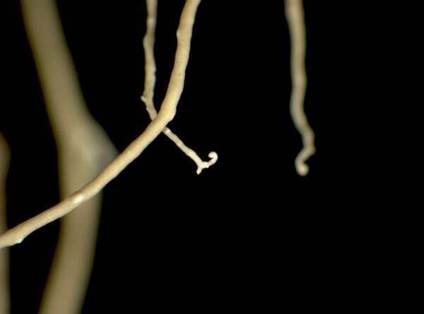
hook-shaped soralium

Triin Aimla; Owner: University of Tartu

P.L.Nimis; Owner: Department of Life Sciences, University of Trieste
Herbarium: TSB (36787)
2008.02.25

Leif Stridvall - Source: http://www.stridvall.se/la/galleries.php
Felix Schumm - CC BY-SA 4.0
[9141], Spanien, Kanarische Inseln, La Gomera, Chorros de Epina, zwischen Arure und Vallehermoso. Im Lorbeer-Erica Wald, 28°09.830' N, 17°17.852 W, 750-850 m. Leg et det. F. Schumm 10.02.2002

Felix Schumm - CC BY-SA 4.0
[9141], Spanien, Kanarische Inseln, La Gomera, Chorros de Epina, zwischen Arure und Vallehermoso. Im Lorbeer-Erica Wald, 28°09.830' N, 17°17.852 W, 750-850 m. Leg et det. F. Schumm 10.02.2002

Felix Schumm - CC BY-SA 4.0
[9141], Spanien, Kanarische Inseln, La Gomera, Chorros de Epina, zwischen Arure und Vallehermoso. Im Lorbeer-Erica Wald, 28°09.830' N, 17°17.852 W, 750-850 m. Leg et det. F. Schumm 10.02.2002

Felix Schumm - CC BY-SA 4.0
[9141], Spanien, Kanarische Inseln, La Gomera, Chorros de Epina, zwischen Arure und Vallehermoso. Im Lorbeer-Erica Wald, 28°09.830' N, 17°17.852 W, 750-850 m. Leg et det. F. Schumm 10.02.2002

Felix Schumm - CC BY-SA 4.0
[9141], Spanien, Kanarische Inseln, La Gomera, Chorros de Epina, zwischen Arure und Vallehermoso. Im Lorbeer-Erica Wald, 28°09.830' N, 17°17.852 W, 750-850 m. Leg et det. F. Schumm 10.02.2002

Felix Schumm - CC BY-SA 4.0
[9141], Spanien, Kanarische Inseln, La Gomera, Chorros de Epina, zwischen Arure und Vallehermoso. Im Lorbeer-Erica Wald, 28°09.830' N, 17°17.852 W, 750-850 m. Leg et det. F. Schumm 10.02.2002

Felix Schumm - CC BY-SA 4.0
[9141], Spanien, Kanarische Inseln, La Gomera, Chorros de Epina, zwischen Arure und Vallehermoso. Im Lorbeer-Erica Wald, 28°09.830' N, 17°17.852 W, 750-850 m. Leg et det. F. Schumm 10.02.2002

Leif Stridvall
Courtesy: Anita Stridvall

Leif Stridvall
Courtesy: Anita Stridvall
Growth form: Fruticose
Substrata: bark
Photobiont: green algae other than Trentepohlia
Reproductive strategy: mainly asexual, by soredia, or soredia-like structures (e.g. blastidia)
Most common in areas with a humid-warm climate (e.g. most of Tyrrenian Italy)
Commonnes-rarity: (info)
Alpine belt: absent
Subalpine belt: extremely rare
Oromediterranean belt: absent
Montane belt: very rare
Submediterranean belt: absent
Padanian area: absent
Humid submediterranean belt: absent
Humid mediterranean belt: absent
Dry mediterranean belt: absent
Predictive model
| Herbarium samples |

Felix Schumm – CC BY-SA 4.0
Image from: F. Schumm (2008) - Flechten Madeiras, der Kanaren und Azoren. Beck, OHG - ISBN: 978-3-00-023700-3

P.L. Nimis; Owner: Department of Life Sciences, University of Trieste
Herbarium: TSB (3692)
2001/12/07
hook-shaped soralium

Triin Aimla; Owner: University of Tartu

P.L.Nimis; Owner: Department of Life Sciences, University of Trieste
Herbarium: TSB (36787)
2008.02.25

Leif Stridvall - Source: http://www.stridvall.se/la/galleries.php

Felix Schumm - CC BY-SA 4.0
[9141], Spanien, Kanarische Inseln, La Gomera, Chorros de Epina, zwischen Arure und Vallehermoso. Im Lorbeer-Erica Wald, 28°09.830' N, 17°17.852 W, 750-850 m. Leg et det. F. Schumm 10.02.2002

Felix Schumm - CC BY-SA 4.0
[9141], Spanien, Kanarische Inseln, La Gomera, Chorros de Epina, zwischen Arure und Vallehermoso. Im Lorbeer-Erica Wald, 28°09.830' N, 17°17.852 W, 750-850 m. Leg et det. F. Schumm 10.02.2002

Felix Schumm - CC BY-SA 4.0
[9141], Spanien, Kanarische Inseln, La Gomera, Chorros de Epina, zwischen Arure und Vallehermoso. Im Lorbeer-Erica Wald, 28°09.830' N, 17°17.852 W, 750-850 m. Leg et det. F. Schumm 10.02.2002

Felix Schumm - CC BY-SA 4.0
[9141], Spanien, Kanarische Inseln, La Gomera, Chorros de Epina, zwischen Arure und Vallehermoso. Im Lorbeer-Erica Wald, 28°09.830' N, 17°17.852 W, 750-850 m. Leg et det. F. Schumm 10.02.2002

Felix Schumm - CC BY-SA 4.0
[9141], Spanien, Kanarische Inseln, La Gomera, Chorros de Epina, zwischen Arure und Vallehermoso. Im Lorbeer-Erica Wald, 28°09.830' N, 17°17.852 W, 750-850 m. Leg et det. F. Schumm 10.02.2002
Felix Schumm - CC BY-SA 4.0
[9141], Spanien, Kanarische Inseln, La Gomera, Chorros de Epina, zwischen Arure und Vallehermoso. Im Lorbeer-Erica Wald, 28°09.830' N, 17°17.852 W, 750-850 m. Leg et det. F. Schumm 10.02.2002

Felix Schumm - CC BY-SA 4.0
[9141], Spanien, Kanarische Inseln, La Gomera, Chorros de Epina, zwischen Arure und Vallehermoso. Im Lorbeer-Erica Wald, 28°09.830' N, 17°17.852 W, 750-850 m. Leg et det. F. Schumm 10.02.2002

Leif Stridvall
Courtesy: Anita Stridvall