Verrucaria dolosa Hepp
Flecht. Eur.: nr. 689, 1860.
Synonyms: Verrucaria krempelhuberi Lindau; Verrucaria mutabilis auct. p.p. non Leight.
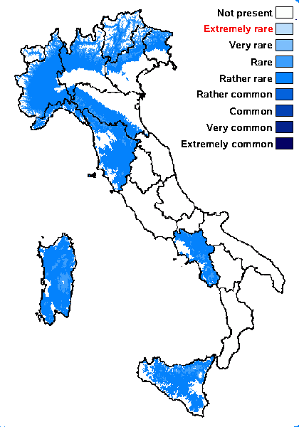
Distribution: N - Frl, Ven (Nascimbene & Nimis 2007, Nascimbene 2008, Nascimbene & al. 2009), TAA (Nascimbene & al. 2022), Lomb, Piem (Favero-Longo & al. 2015, Gheza & Nascimbene 2024), VA (Favero-Longo & al. 2006, Isocrono & al. 2008, Favero-Longo & Piervittori 2009), Emil (Nimis & al. 1996, Fariselli & al. 2020), Lig (Giordani & al. 2016). C - Tosc, Sar (Rizzi & al. 2011, Giordani & al. 2013). S - Camp (Nimis & Tretiach 2004), Si (Grillo & al. 2007, 2007b).
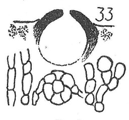
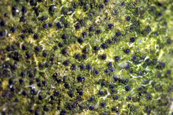
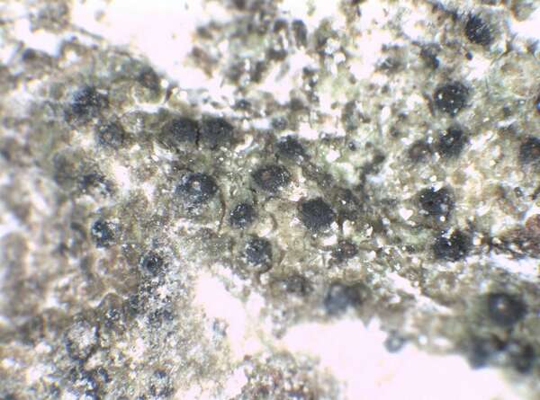
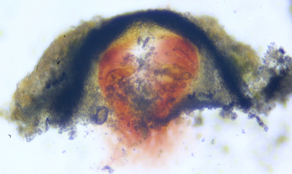
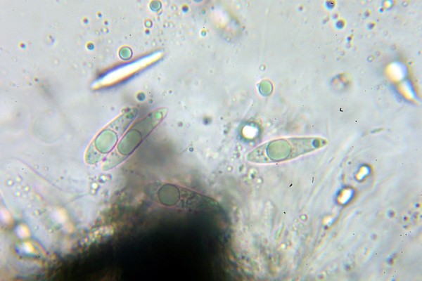
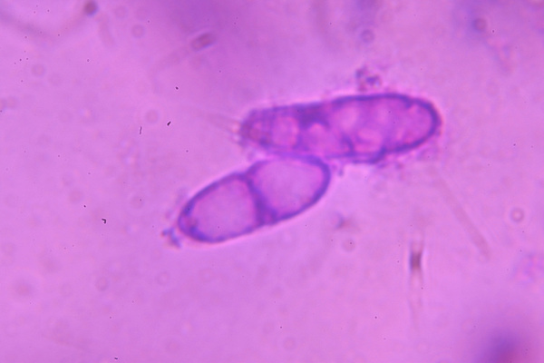
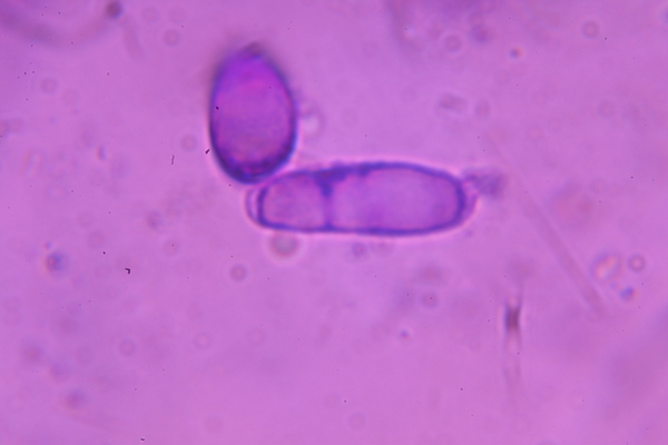
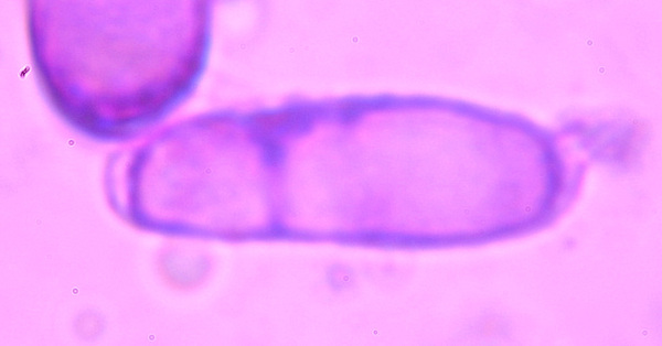
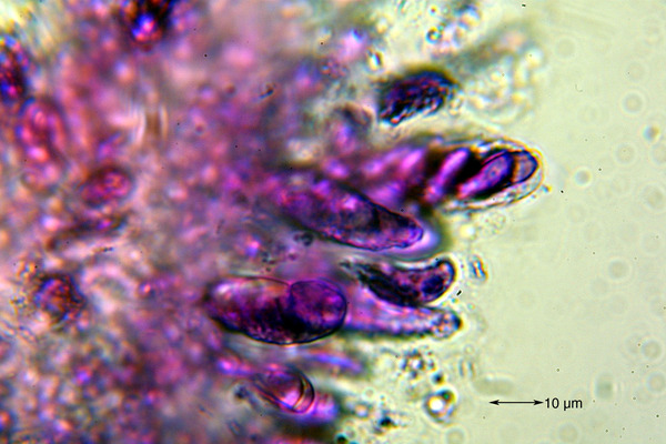
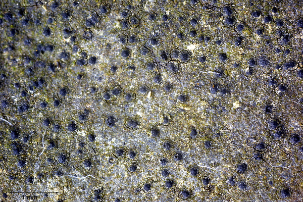
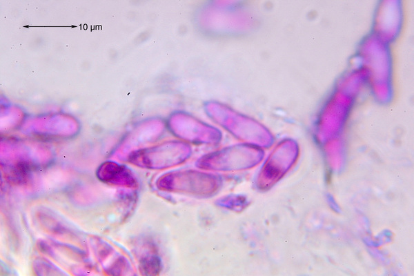
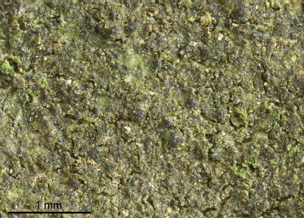
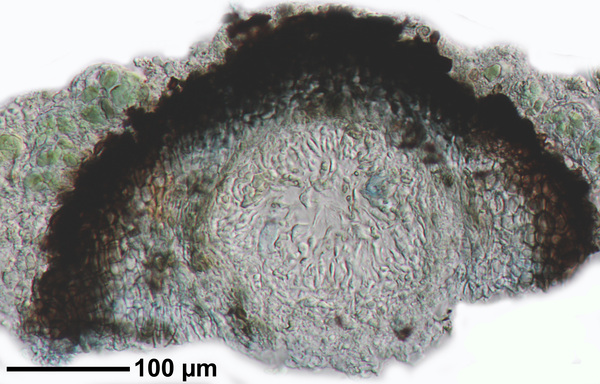
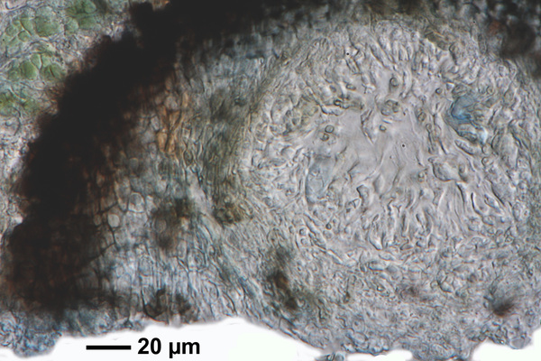
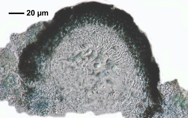
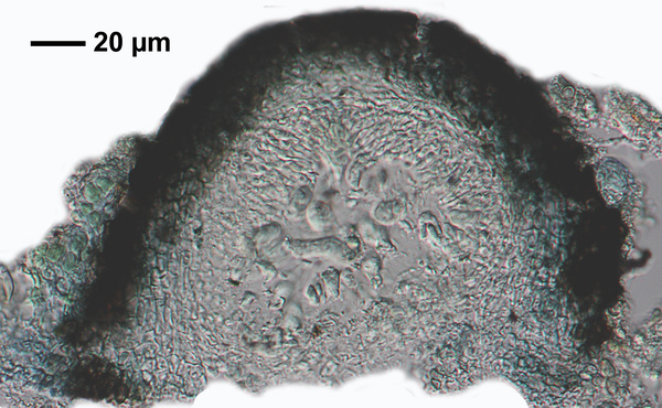
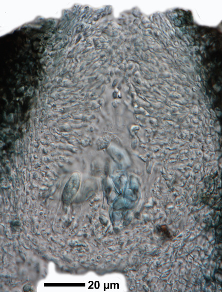
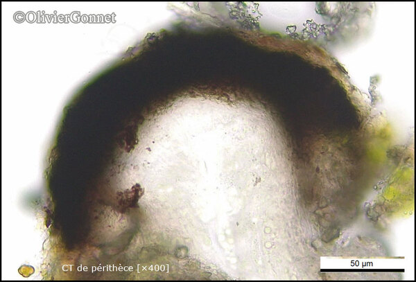
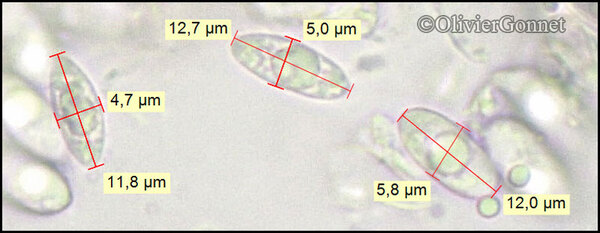
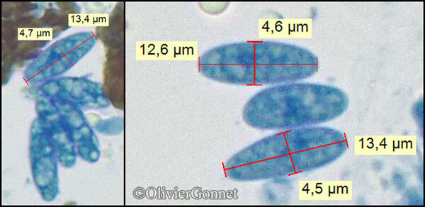
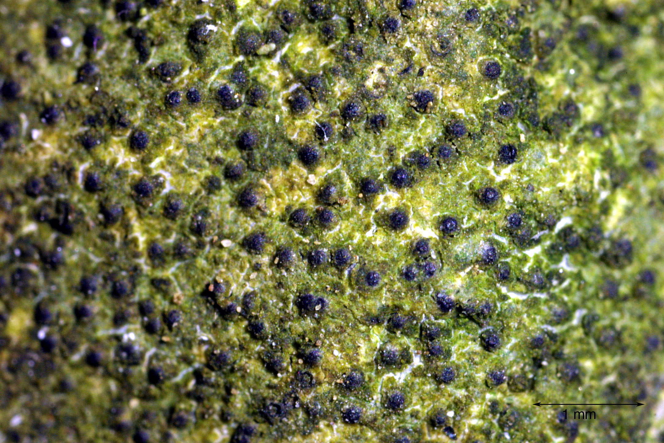
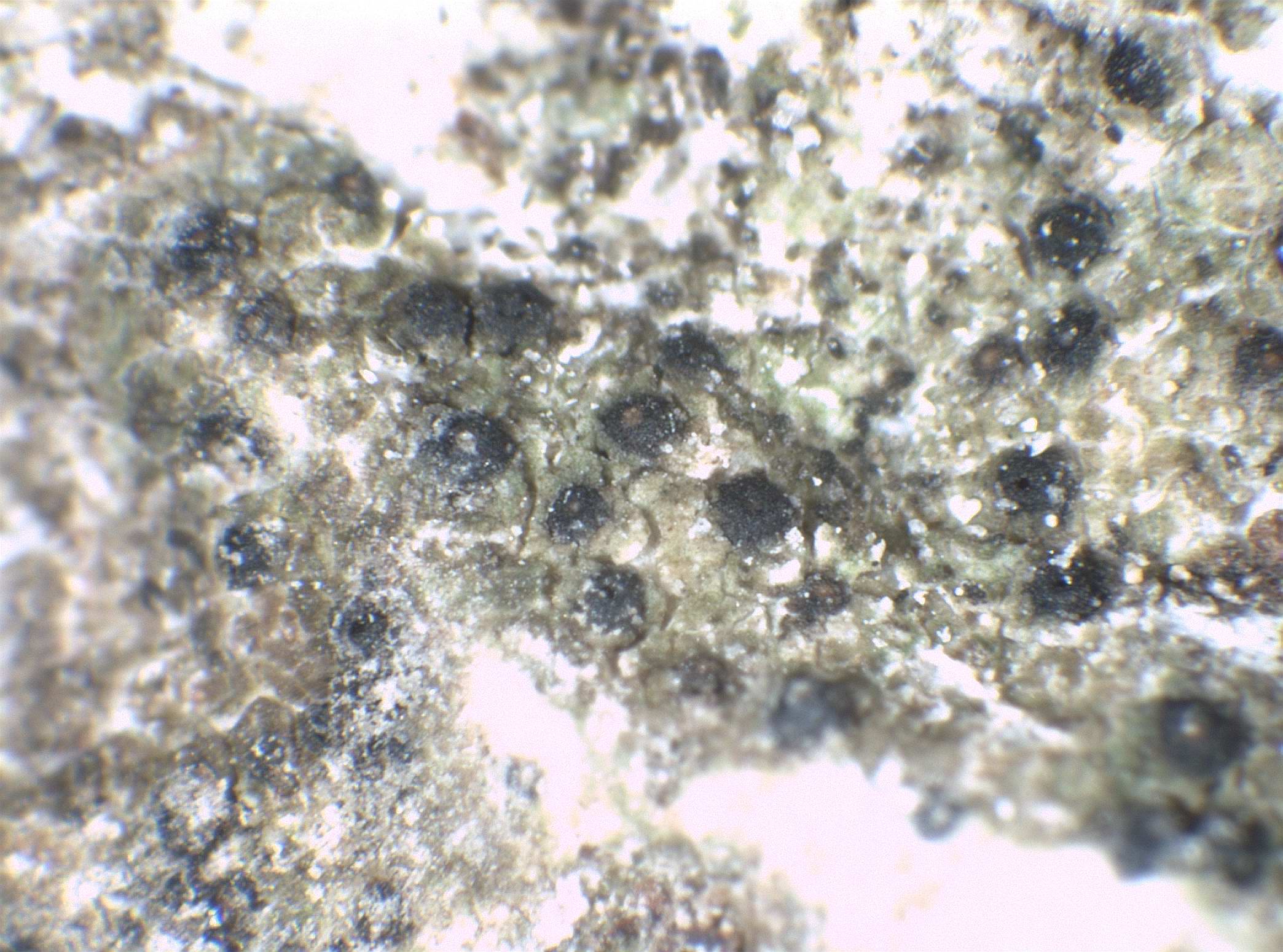
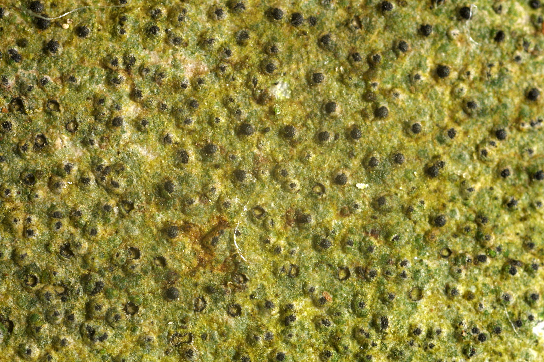
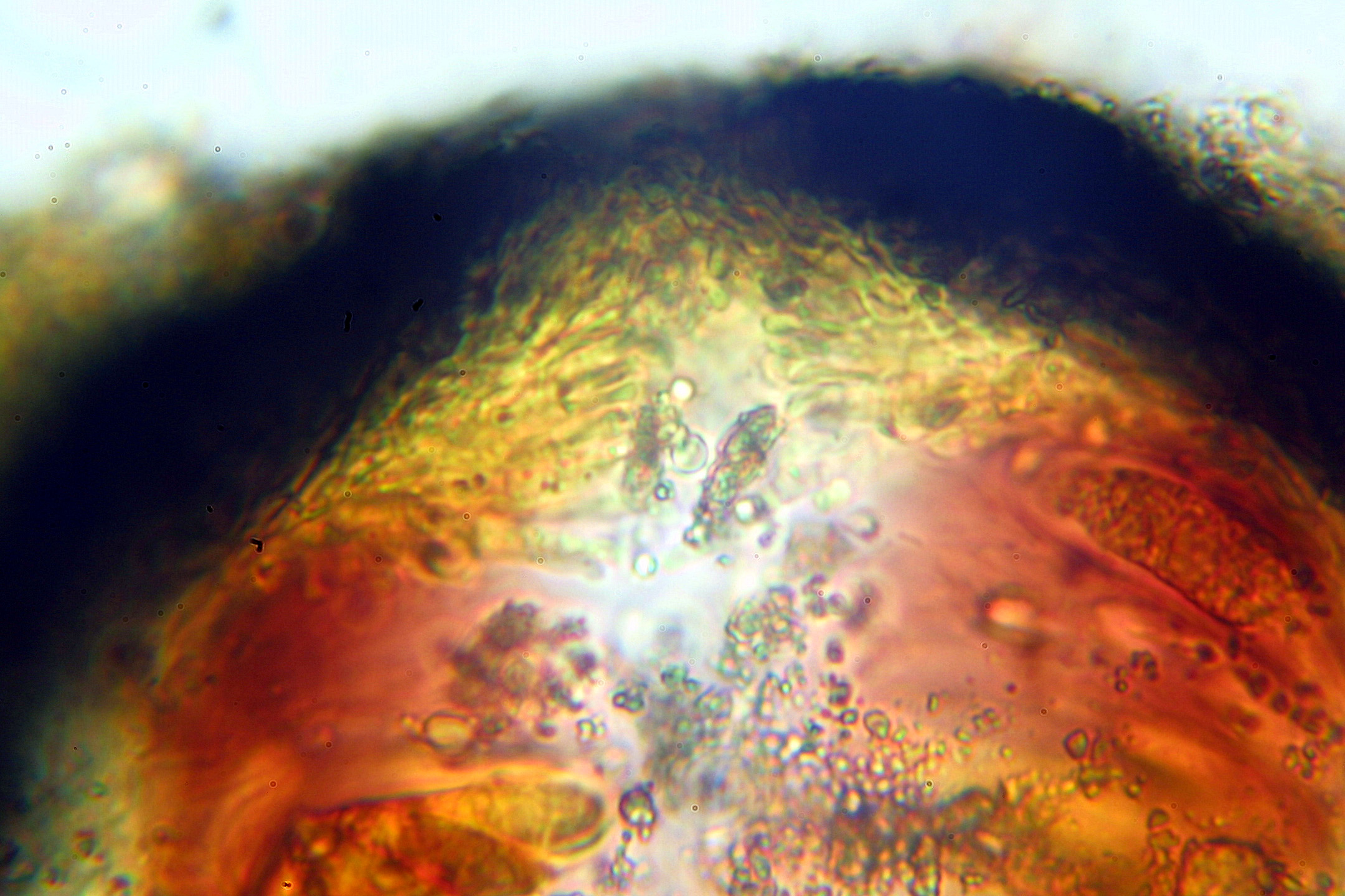
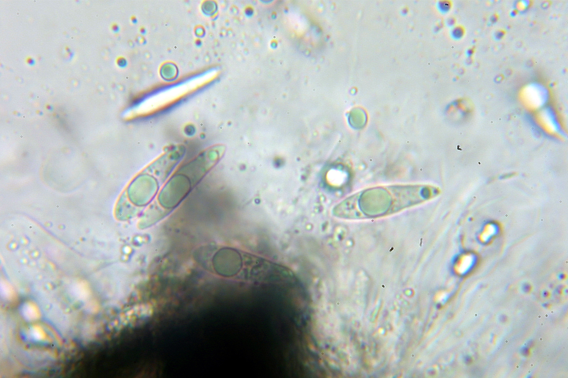
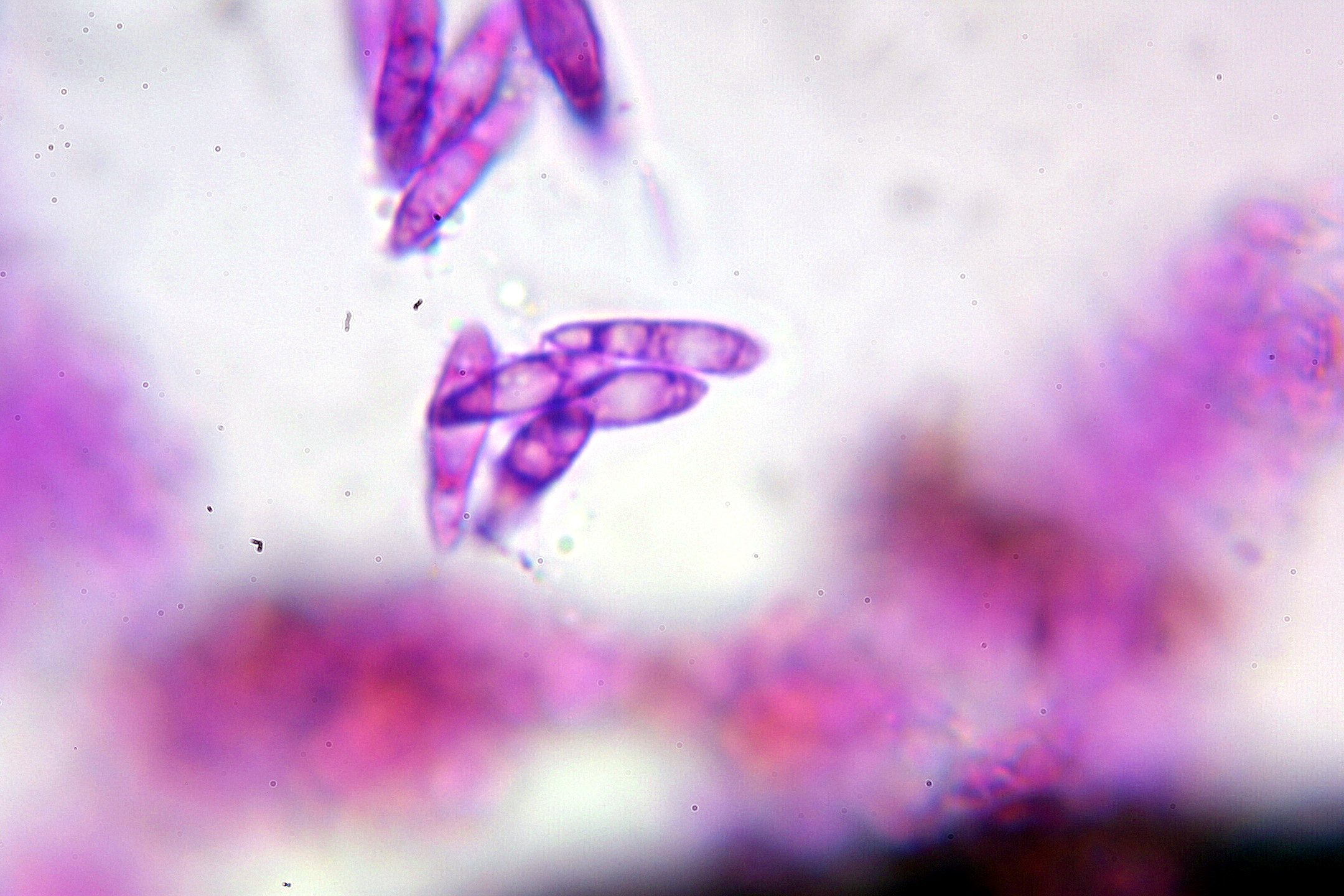
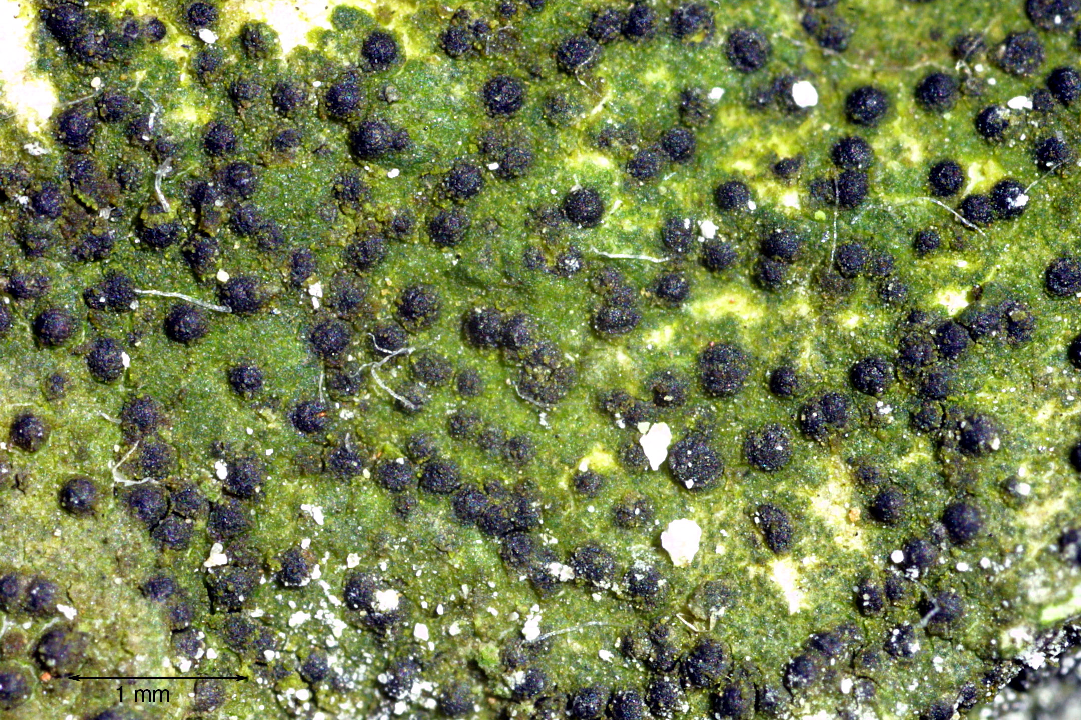
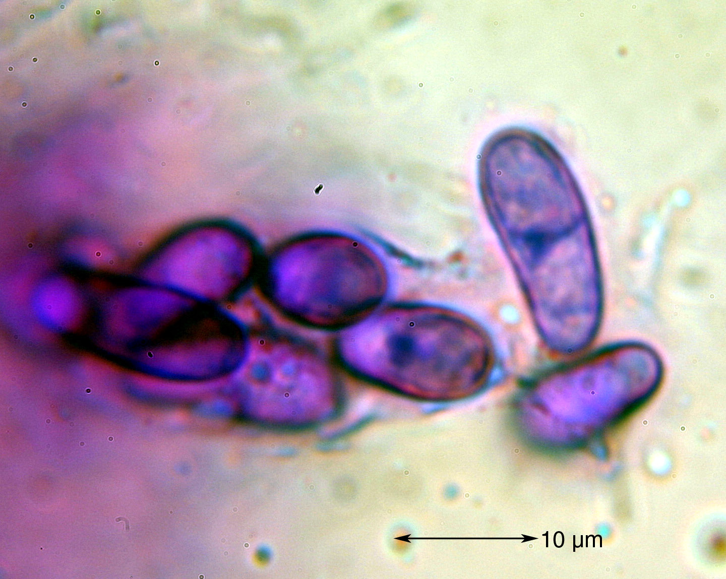
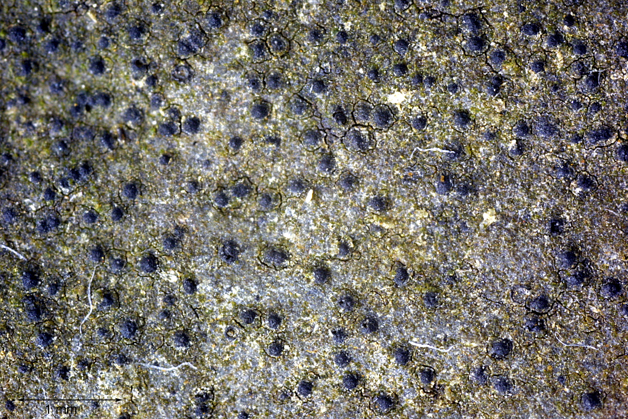
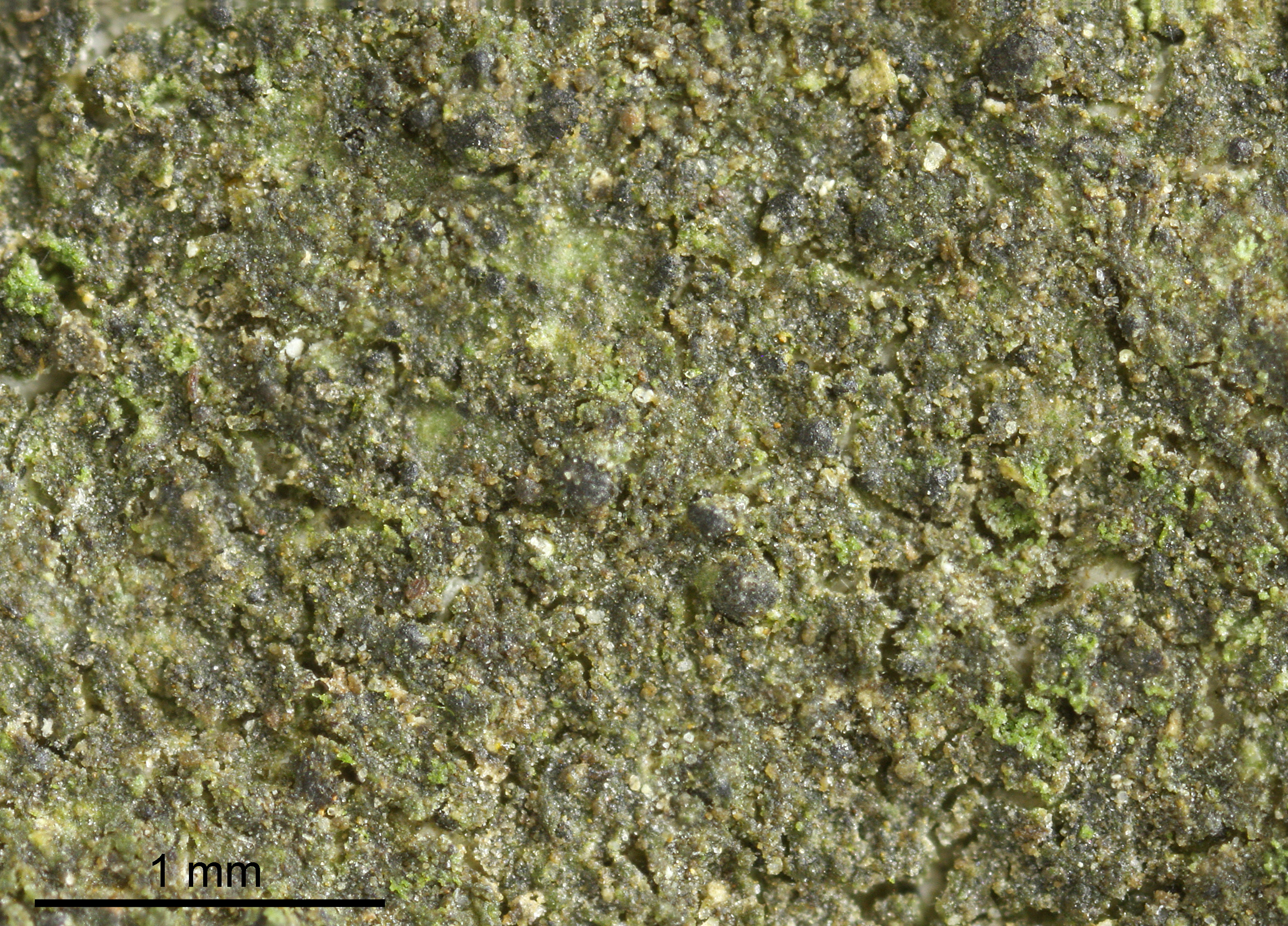
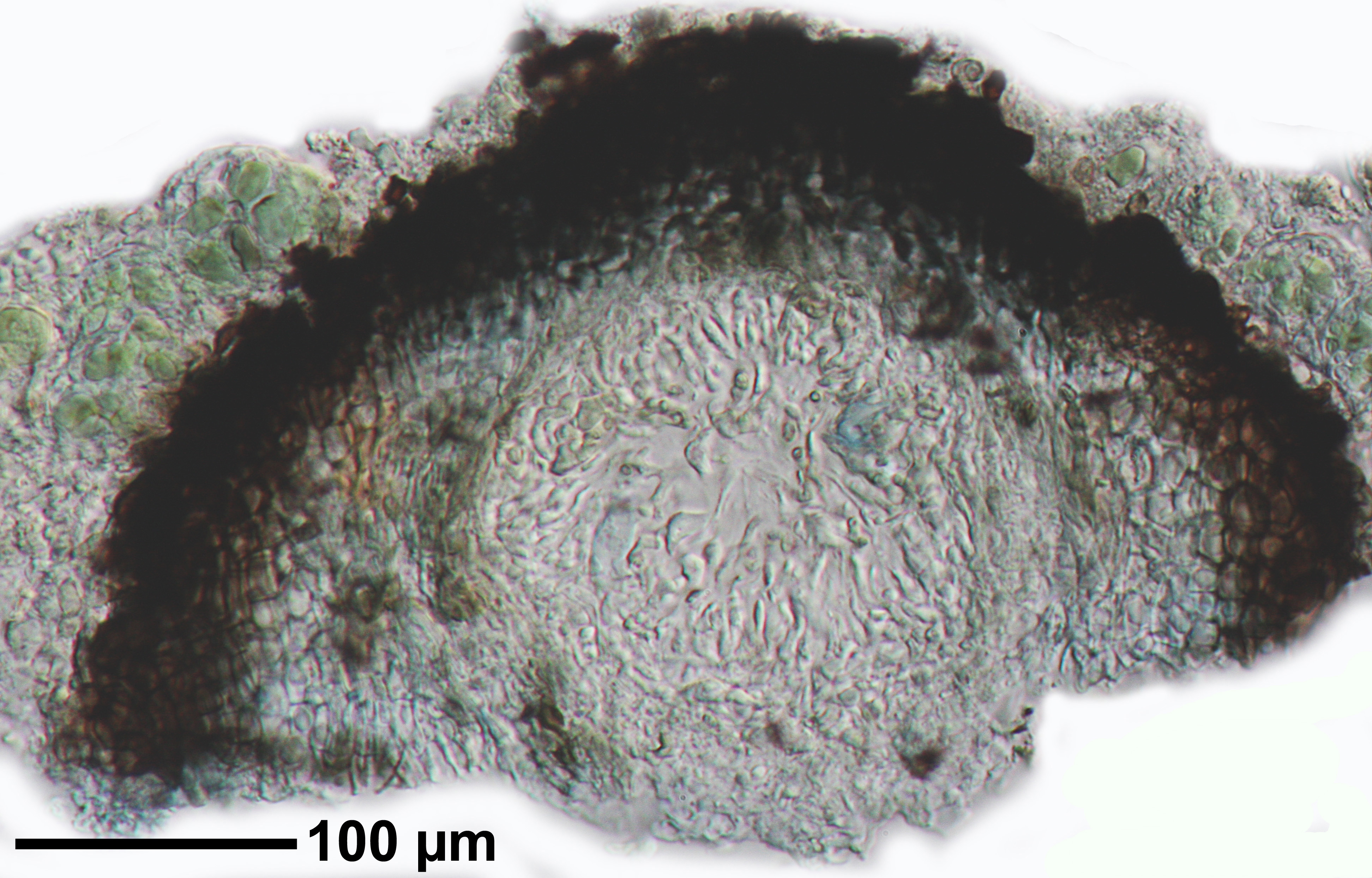
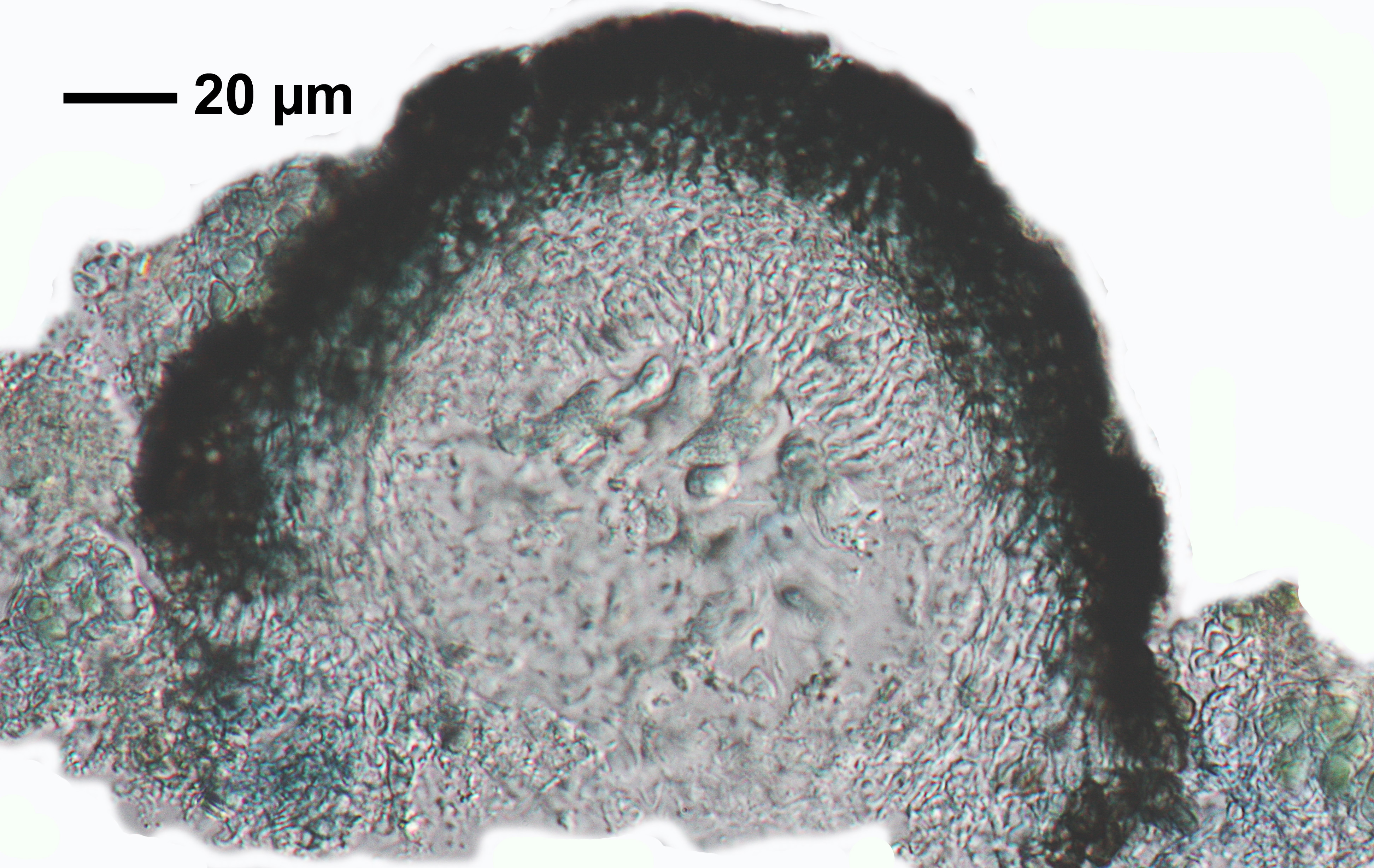
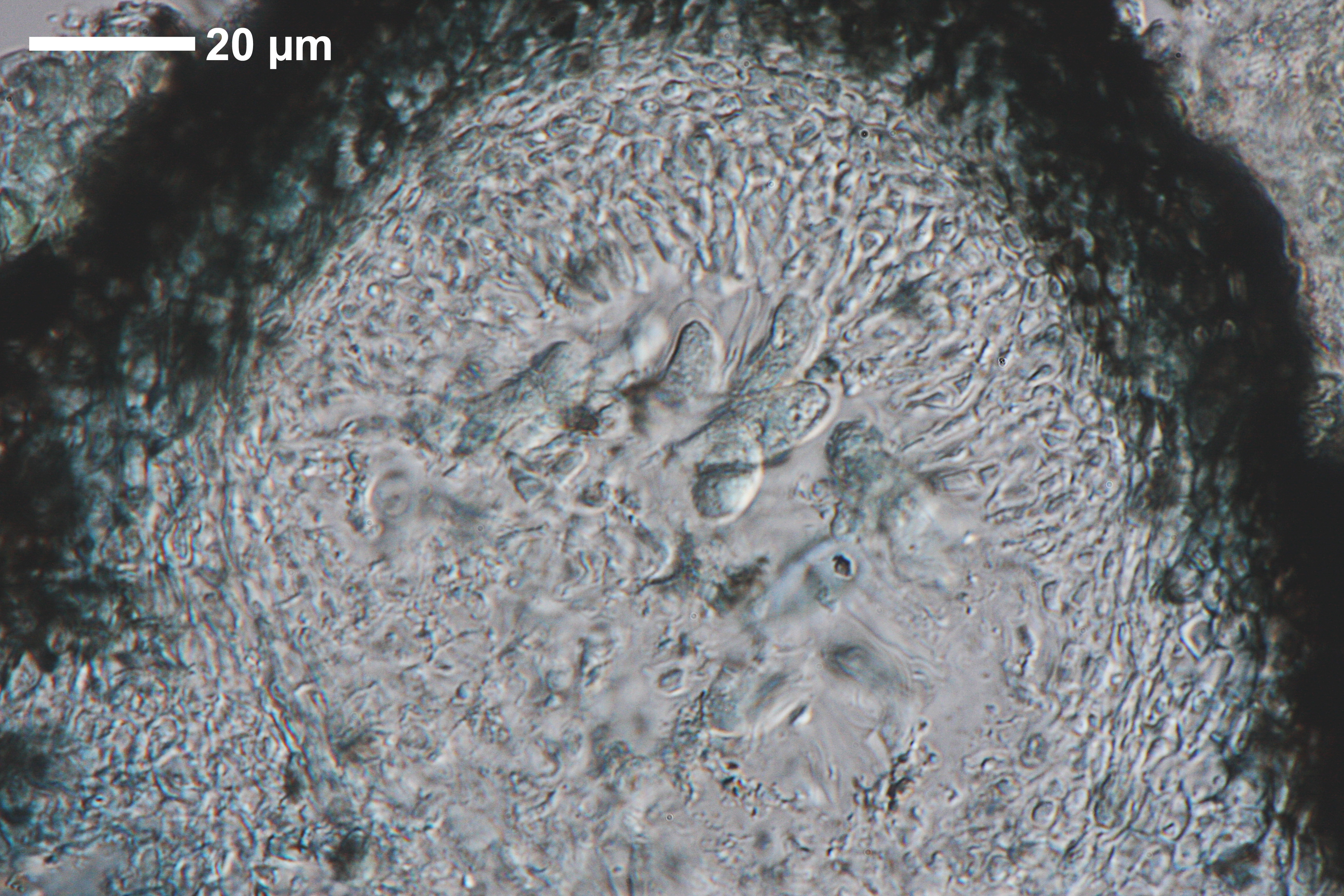
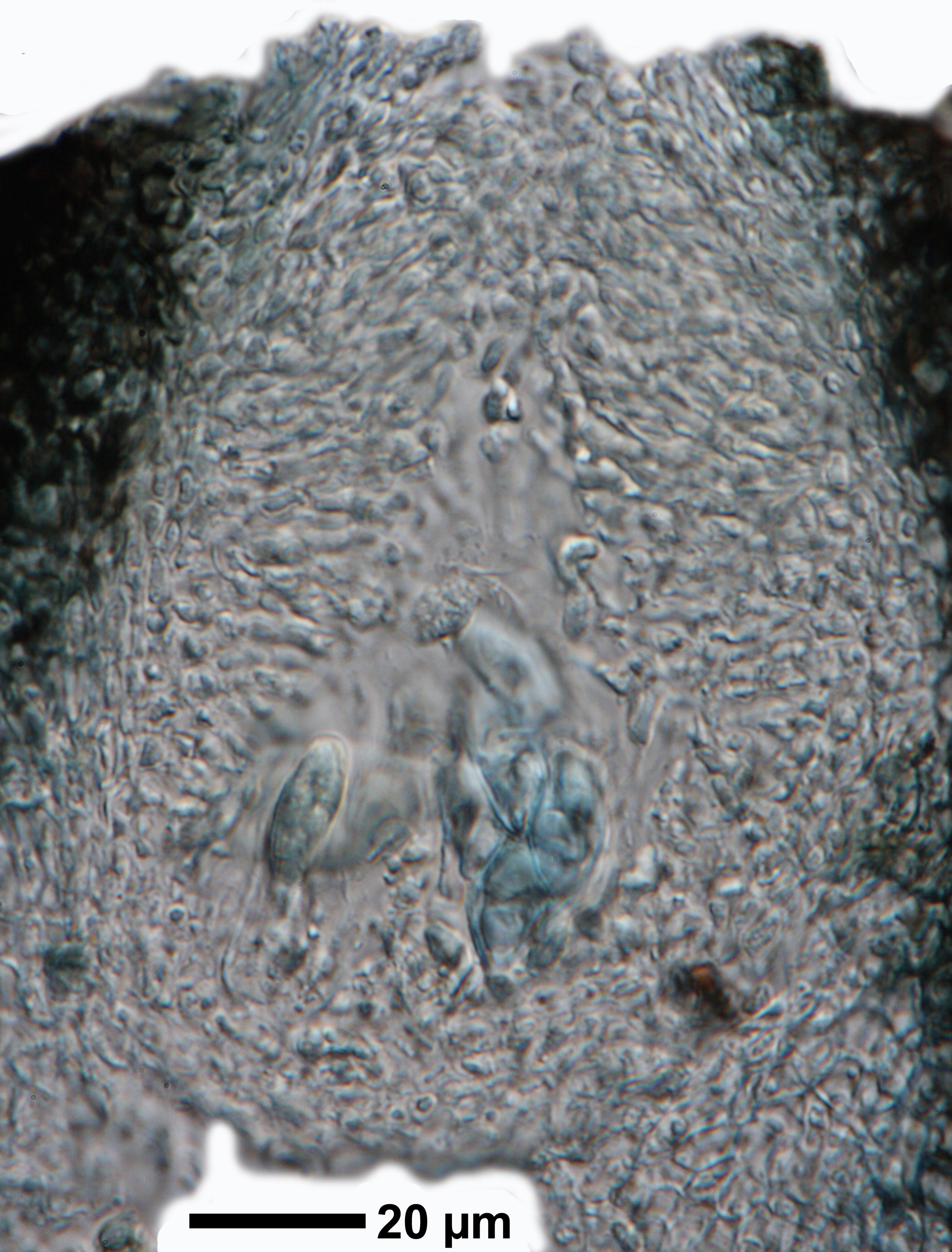
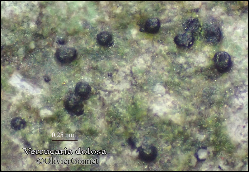
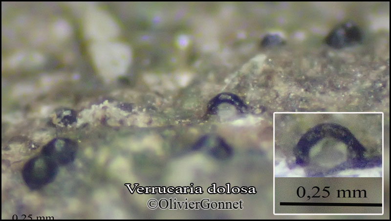
Description: Thallus crustose, episubstratic or hemiendosubstratic, 25-50 μm thick, smooth to uneven, continuous to patchy or reduced to small flecks, rarely areolate, not subgelatinous when wet, ochraceous, grey-green or brown, sometimes with a poorly evident brown prothallus; areoles, when developed, 0.2-0.3 mm wide, separated by pale fissures. Cortex poorly developed, proso- to paraplectenchymatous, often 1-layered; algal layer compact, c. 30 μm thick; medulla white, thin, paraplectenchymatous, the thallus filled by numerous crystals which reach the algal layer. Perithecia black, shiny, numerous (200-360/cm²), forming low to moderate, subconical to hemispherical, 0.14-0.36(-0.4) mm wide projections. Involucrellum shallowly conical, homogeneously thick (20-40 μm), reaching to base-level, adpressed to exciple only in upper part, diverging in lower part; area between base of exciple and involucrellum filled with dark-coloured cells; exciple globose, 0.15-0.2 mm across, the wall colourless to very pale brown near the ostiole; hamathecium of 5-25(-30) μm long periphyses and periphysoids, interascal filaments absent; hymenial gel hemiamyloid, I+ red (I+ blue at very low concentrations of I), K/I+ blue. Asci 8-spored, clavate, I-, fissitunicate, the wall thickened above, with an ocular chamber, dehiscent by extrusion of an endotunica to form a delicate rostrum, Verrucaria-type. Ascospores 1-celled, hyaline, narrowly ellipsoid to (rarely) ovoid, (11-)13-18(-21.5) x (4-)5-8(-10) μm, without a gelatinous perispore. Photobiont chlorococcoid, the cells not arranged in vertical columns. Spot tests: K-, C-, KC-, P-, UV-. Chemistry: without lichen substances.
Note: a probably holarctic early coloniser of small pebbles near the ground, growing both on calcareous and base-rich siliceous rocks in sheltered situations, such as in open woodlands and in moist habitats by watercourses, e.g. in the splash zone. The species is related to V. hydrophila (Orange 2013).
Growth form: Crustose
Substrata: rocks
Photobiont: green algae other than Trentepohlia
Reproductive strategy: mainly sexual
Pioneer species
Commonnes-rarity: (info)
Alpine belt: absent
Subalpine belt: absent
Oromediterranean belt: absent
Montane belt: rare
Submediterranean belt: rather rare
Padanian area: absent
Humid submediterranean belt: rather rare
Humid mediterranean belt: absent
Dry mediterranean belt: absent
Predictive model
Herbarium samples
Felix Schumm - CC BY-SA 4.0
[12253], Germany, Baden-Württemberg, Alb-Donau Kreis, nördlich von Urspring bei der Bahnunterführung an der Straße nach Amstetten, auf Kalkblöcken und Kalksteinen in Bodennähe, sonnig, windoffen; 48°33,296' , 9°53,42' E, 570 m. Leg. Schumm 29.10.2005, det. Schumm 11.2005

P.L. Nimis; Owner: Department of Life Sciences, University of Trieste
Herbarium: TSB (16856)
2003/03/17

Felix Schumm - CC BY-SA 4.0
[11588], Germany, Baden-Württemberg, Kreis Göppingen, 1 km nördlich Wißgolding, Rand des Stuifens am Hinterbergweg, 48°44,721' N, 9°49,644' W, 644 m, Waldrand, lichtoffen, Kalk(!)-Steinchen am Weg. Leg. Schumm 20.03.2004, det. Schumm 04.2004
Felix Schumm - CC BY-SA 4.0
[11588], Germany, Baden-Württemberg, Kreis Göppingen, 1 km nördlich Wißgolding, Rand des Stuifens am Hinterbergweg, 48°44,721' N, 9°49,644' W, 644 m, Waldrand, lichtoffen, Kalk(!)-Steinchen am Weg. Leg. Schumm 20.03.2004, det. Schumm 04.2004

Felix Schumm - CC BY-SA 4.0
[11588], Germany, Baden-Württemberg, Kreis Göppingen, 1 km nördlich Wißgolding, Rand des Stuifens am Hinterbergweg, 48°44,721' N, 9°49,644' W, 644 m, Waldrand, lichtoffen, Kalk(!)-Steinchen am Weg. Leg. Schumm 20.03.2004, det. Schumm 04.2004
Felix Schumm - CC BY-SA 4.0
[11588], Germany, Baden-Württemberg, Kreis Göppingen, 1 km nördlich Wißgolding, Rand des Stuifens am Hinterbergweg, 48°44,721' N, 9°49,644' W, 644 m, Waldrand, lichtoffen, Kalk(!)-Steinchen am Weg. Leg. Schumm 20.03.2004, det. Schumm 04.2004

Felix Schumm - CC BY-SA 4.0
[11588], Germany, Baden-Württemberg, Kreis Göppingen, 1 km nördlich Wißgolding, Rand des Stuifens am Hinterbergweg, 48°44,721' N, 9°49,644' W, 644 m, Waldrand, lichtoffen, Kalk(!)-Steinchen am Weg. Leg. Schumm 20.03.2004, det. Schumm 04.2004
Felix Schumm - CC BY-SA 4.0
[11588], Germany, Baden-Württemberg, Kreis Göppingen, 1 km nördlich Wißgolding, Rand des Stuifens am Hinterbergweg, 48°44,721' N, 9°49,644' W, 644 m, Waldrand, lichtoffen, Kalk(!)-Steinchen am Weg. Leg. Schumm 20.03.2004, det. Schumm 04.2004
Felix Schumm - CC BY-SA 4.0
[11588], Germany, Baden-Württemberg, Kreis Göppingen, 1 km nördlich Wißgolding, Rand des Stuifens am Hinterbergweg, 48°44,721' N, 9°49,644' W, 644 m, Waldrand, lichtoffen, Kalk(!)-Steinchen am Weg. Leg. Schumm 20.03.2004, det. Schumm 04.2004
Felix Schumm - CC BY-SA 4.0
[11588], Germany, Baden-Württemberg, Kreis Göppingen, 1 km nördlich Wißgolding, Rand des Stuifens am Hinterbergweg, 48°44,721' N, 9°49,644' W, 644 m, Waldrand, lichtoffen, Kalk(!)-Steinchen am Weg. Leg. Schumm 20.03.2004, det. Schumm 04.2004

Felix Schumm - CC BY-SA 4.0
[12253], Germany, Baden-Württemberg, Alb-Donau Kreis, nördlich von Urspring bei der Bahnunterführung an der Straße nach Amstetten, auf Kalkblöcken und Kalksteinen in Bodennähe, sonnig, windoffen; 48°33,296' , 9°53,42' E, 570 m. Leg. Schumm 29.10.2005, det. Schumm 11.2005
Felix Schumm - CC BY-SA 4.0
[12253], Germany, Baden-Württemberg, Alb-Donau Kreis, nördlich von Urspring bei der Bahnunterführung an der Straße nach Amstetten, auf Kalkblöcken und Kalksteinen in Bodennähe, sonnig, windoffen; 48°33,296' , 9°53,42' E, 570 m. Leg. Schumm 29.10.2005, det. Schumm 11.2005

Felix Schumm - CC BY-SA 4.0
[12253], Germany, Baden-Württemberg, Alb-Donau Kreis, nördlich von Urspring bei der Bahnunterführung an der Straße nach Amstetten, auf Kalkblöcken und Kalksteinen in Bodennähe, sonnig, windoffen; 48°33,296' , 9°53,42' E, 570 m. Leg. Schumm 29.10.2005, det. Schumm 11.2005
Felix Schumm - CC BY-SA 4.0
[12323], Rheinland Pfalz, Kreis Ahrweiler, Dreisbachtal bei Fuchshofen, Unterdevon, Bleiabbaugebiet. Leg. Schumm & Düll 22.06.2006, det. Schumm 2006.
Felix Schumm - CC BY-SA 4.0
[12323], Rheinland Pfalz, Kreis Ahrweiler, Dreisbachtal bei Fuchshofen, Unterdevon, Bleiabbaugebiet. Leg. Schumm & Düll 22.06.2006, det. Schumm 2006.
Felix Schumm - CC BY-SA 4.0
[16563], Germany, Baden-Württemberg, Kreis Göppingen, Messelstein bei Donzdorf, 48,69045° N, 9,83113° E, 750 m. Am Waldboden im Schatten liegende Kalksteinchen. Leg.. Schumm 25.07.2010, det. A.Aptroot 2011.
Felix Schumm - CC BY-SA 4.0
[16563], Germany, Baden-Württemberg, Kreis Göppingen, Messelstein bei Donzdorf, 48,69045° N, 9,83113° E, 750 m. Am Waldboden im Schatten liegende Kalksteinchen. Leg.. Schumm 25.07.2010, det. A.Aptroot 2011.
Felix Schumm - CC BY-SA 4.0
[16563], Germany, Baden-Württemberg, Kreis Göppingen, Messelstein bei Donzdorf, 48,69045° N, 9,83113° E, 750 m. Am Waldboden im Schatten liegende Kalksteinchen. Leg.. Schumm 25.07.2010, det. A.Aptroot 2011.
Felix Schumm - CC BY-SA 4.0
[16563], Germany, Baden-Württemberg, Kreis Göppingen, Messelstein bei Donzdorf, 48,69045° N, 9,83113° E, 750 m. Am Waldboden im Schatten liegende Kalksteinchen. Leg.. Schumm 25.07.2010, det. A.Aptroot 2011.

Felix Schumm - CC BY-SA 4.0
[16563], Germany, Baden-Württemberg, Kreis Göppingen, Messelstein bei Donzdorf, 48,69045° N, 9,83113° E, 750 m. Am Waldboden im Schatten liegende Kalksteinchen. Leg.. Schumm 25.07.2010, det. A.Aptroot 2011.
Felix Schumm - CC BY-SA 4.0
[16563], Germany, Baden-Württemberg, Kreis Göppingen, Messelstein bei Donzdorf, 48,69045° N, 9,83113° E, 750 m. Am Waldboden im Schatten liegende Kalksteinchen. Leg.. Schumm 25.07.2010, det. A.Aptroot 2011.
Felix Schumm - CC BY-SA 4.0
[16563], Germany, Baden-Württemberg, Kreis Göppingen, Messelstein bei Donzdorf, 48,69045° N, 9,83113° E, 750 m. Am Waldboden im Schatten liegende Kalksteinchen. Leg.. Schumm 25.07.2010, det. A.Aptroot 2011.

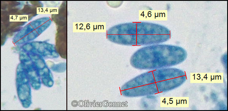
Courtesy Danièle et Olivier Gonnet - Source: https://www.afl-lichenologie.fr/Photos_AFL/Photos_AFL_V/Texte_V/Verrucaria_dolosa.htm
France, 5/5/2018 - Poleymieux-au-Mont-d’Or - Rhöne - (69) - ancienne carrière, alt. 400 m, sur escarpement ombragé de roche calcaire

Courtesy Danièle et Olivier Gonnet - Source: https://www.afl-lichenologie.fr/Photos_AFL/Photos_AFL_V/Texte_V/Verrucaria_dolosa.htm
France, 5/5/2018 - Poleymieux-au-Mont-d’Or - Rhöne - (69) - ancienne carrière, alt. 400 m, sur escarpement ombragé de roche calcaire
Courtesy Danièle et Olivier Gonnet - Source: https://www.afl-lichenologie.fr/Photos_AFL/Photos_AFL_V/Texte_V/Verrucaria_dolosa.htm
France, 5/5/2018 - Poleymieux-au-Mont-d’Or - Rhöne - (69) - ancienne carrière, alt. 400 m, sur escarpement ombragé de roche calcaire
Courtesy Danièle et Olivier Gonnet - Source: https://www.afl-lichenologie.fr/Photos_AFL/Photos_AFL_V/Texte_V/Verrucaria_dolosa.htm
France, 5/5/2018 - Poleymieux-au-Mont-d’Or - Rhöne - (69) - ancienne carrière, alt. 400 m, sur escarpement ombragé de roche calcaire
Courtesy Danièle et Olivier Gonnet - Source: https://www.afl-lichenologie.fr/Photos_AFL/Photos_AFL_V/Texte_V/Verrucaria_dolosa.htm
France, 5/5/2018 - Poleymieux-au-Mont-d’Or - Rhöne - (69) - ancienne carrière, alt. 400 m, sur escarpement ombragé de roche calcaire
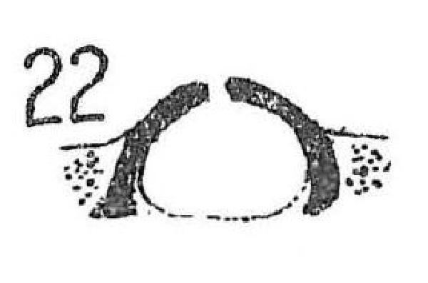
Source: Servit, M 1949: Nove nebo mene zname druhy lisejnikove celedi Verrucariaceae. Species Verrucariacearum (Lichenes) novae vel minus cognitae. - Sbornik Narodniho Musea v Praze 5(9): 1-51. Tab.1 - Public Domain
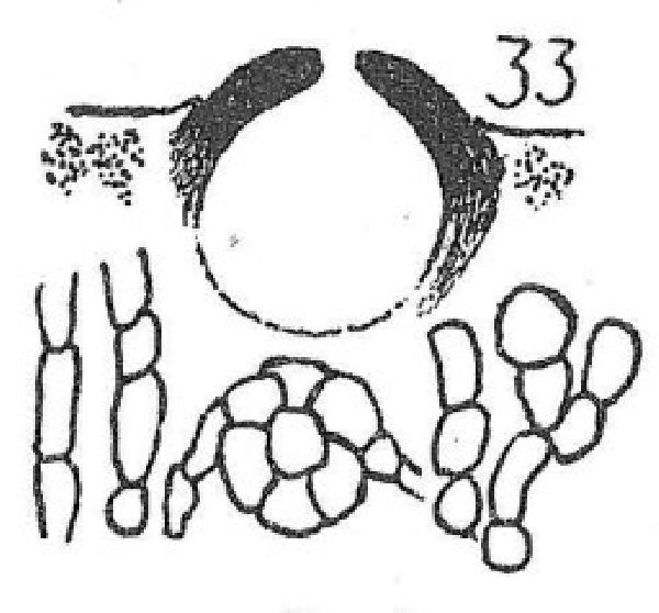
Source: Servit, M 1949: Nove nebo mene zname druhy lisejnikove celedi Verrucariaceae. Species Verrucariacearum (Lichenes) novae vel minus cognitae. - Sbornik Narodniho Musea v Praze 5(9): 1-51. Tab.2 - Public Domain
as Verrucaria krempelhuberi
Growth form: Crustose
Substrata: rocks
Photobiont: green algae other than Trentepohlia
Reproductive strategy: mainly sexual
Pioneer species
Commonnes-rarity: (info)
Alpine belt: absent
Subalpine belt: absent
Oromediterranean belt: absent
Montane belt: rare
Submediterranean belt: rather rare
Padanian area: absent
Humid submediterranean belt: rather rare
Humid mediterranean belt: absent
Dry mediterranean belt: absent
Predictive model
| Herbarium samples |
Felix Schumm - CC BY-SA 4.0
[12253], Germany, Baden-Württemberg, Alb-Donau Kreis, nördlich von Urspring bei der Bahnunterführung an der Straße nach Amstetten, auf Kalkblöcken und Kalksteinen in Bodennähe, sonnig, windoffen; 48°33,296' , 9°53,42' E, 570 m. Leg. Schumm 29.10.2005, det. Schumm 11.2005
P.L. Nimis; Owner: Department of Life Sciences, University of Trieste
Herbarium: TSB (16856)
2003/03/17
Felix Schumm - CC BY-SA 4.0
[11588], Germany, Baden-Württemberg, Kreis Göppingen, 1 km nördlich Wißgolding, Rand des Stuifens am Hinterbergweg, 48°44,721' N, 9°49,644' W, 644 m, Waldrand, lichtoffen, Kalk(!)-Steinchen am Weg. Leg. Schumm 20.03.2004, det. Schumm 04.2004

Felix Schumm - CC BY-SA 4.0
[11588], Germany, Baden-Württemberg, Kreis Göppingen, 1 km nördlich Wißgolding, Rand des Stuifens am Hinterbergweg, 48°44,721' N, 9°49,644' W, 644 m, Waldrand, lichtoffen, Kalk(!)-Steinchen am Weg. Leg. Schumm 20.03.2004, det. Schumm 04.2004
Felix Schumm - CC BY-SA 4.0
[11588], Germany, Baden-Württemberg, Kreis Göppingen, 1 km nördlich Wißgolding, Rand des Stuifens am Hinterbergweg, 48°44,721' N, 9°49,644' W, 644 m, Waldrand, lichtoffen, Kalk(!)-Steinchen am Weg. Leg. Schumm 20.03.2004, det. Schumm 04.2004
Felix Schumm - CC BY-SA 4.0
[11588], Germany, Baden-Württemberg, Kreis Göppingen, 1 km nördlich Wißgolding, Rand des Stuifens am Hinterbergweg, 48°44,721' N, 9°49,644' W, 644 m, Waldrand, lichtoffen, Kalk(!)-Steinchen am Weg. Leg. Schumm 20.03.2004, det. Schumm 04.2004
Felix Schumm - CC BY-SA 4.0
[11588], Germany, Baden-Württemberg, Kreis Göppingen, 1 km nördlich Wißgolding, Rand des Stuifens am Hinterbergweg, 48°44,721' N, 9°49,644' W, 644 m, Waldrand, lichtoffen, Kalk(!)-Steinchen am Weg. Leg. Schumm 20.03.2004, det. Schumm 04.2004

Felix Schumm - CC BY-SA 4.0
[11588], Germany, Baden-Württemberg, Kreis Göppingen, 1 km nördlich Wißgolding, Rand des Stuifens am Hinterbergweg, 48°44,721' N, 9°49,644' W, 644 m, Waldrand, lichtoffen, Kalk(!)-Steinchen am Weg. Leg. Schumm 20.03.2004, det. Schumm 04.2004

Felix Schumm - CC BY-SA 4.0
[11588], Germany, Baden-Württemberg, Kreis Göppingen, 1 km nördlich Wißgolding, Rand des Stuifens am Hinterbergweg, 48°44,721' N, 9°49,644' W, 644 m, Waldrand, lichtoffen, Kalk(!)-Steinchen am Weg. Leg. Schumm 20.03.2004, det. Schumm 04.2004

Felix Schumm - CC BY-SA 4.0
[11588], Germany, Baden-Württemberg, Kreis Göppingen, 1 km nördlich Wißgolding, Rand des Stuifens am Hinterbergweg, 48°44,721' N, 9°49,644' W, 644 m, Waldrand, lichtoffen, Kalk(!)-Steinchen am Weg. Leg. Schumm 20.03.2004, det. Schumm 04.2004
Felix Schumm - CC BY-SA 4.0
[12253], Germany, Baden-Württemberg, Alb-Donau Kreis, nördlich von Urspring bei der Bahnunterführung an der Straße nach Amstetten, auf Kalkblöcken und Kalksteinen in Bodennähe, sonnig, windoffen; 48°33,296' , 9°53,42' E, 570 m. Leg. Schumm 29.10.2005, det. Schumm 11.2005

Felix Schumm - CC BY-SA 4.0
[12253], Germany, Baden-Württemberg, Alb-Donau Kreis, nördlich von Urspring bei der Bahnunterführung an der Straße nach Amstetten, auf Kalkblöcken und Kalksteinen in Bodennähe, sonnig, windoffen; 48°33,296' , 9°53,42' E, 570 m. Leg. Schumm 29.10.2005, det. Schumm 11.2005
Felix Schumm - CC BY-SA 4.0
[12253], Germany, Baden-Württemberg, Alb-Donau Kreis, nördlich von Urspring bei der Bahnunterführung an der Straße nach Amstetten, auf Kalkblöcken und Kalksteinen in Bodennähe, sonnig, windoffen; 48°33,296' , 9°53,42' E, 570 m. Leg. Schumm 29.10.2005, det. Schumm 11.2005
Felix Schumm - CC BY-SA 4.0
[12323], Rheinland Pfalz, Kreis Ahrweiler, Dreisbachtal bei Fuchshofen, Unterdevon, Bleiabbaugebiet. Leg. Schumm & Düll 22.06.2006, det. Schumm 2006.

Felix Schumm - CC BY-SA 4.0
[12323], Rheinland Pfalz, Kreis Ahrweiler, Dreisbachtal bei Fuchshofen, Unterdevon, Bleiabbaugebiet. Leg. Schumm & Düll 22.06.2006, det. Schumm 2006.
Felix Schumm - CC BY-SA 4.0
[16563], Germany, Baden-Württemberg, Kreis Göppingen, Messelstein bei Donzdorf, 48,69045° N, 9,83113° E, 750 m. Am Waldboden im Schatten liegende Kalksteinchen. Leg.. Schumm 25.07.2010, det. A.Aptroot 2011.
Felix Schumm - CC BY-SA 4.0
[16563], Germany, Baden-Württemberg, Kreis Göppingen, Messelstein bei Donzdorf, 48,69045° N, 9,83113° E, 750 m. Am Waldboden im Schatten liegende Kalksteinchen. Leg.. Schumm 25.07.2010, det. A.Aptroot 2011.

Felix Schumm - CC BY-SA 4.0
[16563], Germany, Baden-Württemberg, Kreis Göppingen, Messelstein bei Donzdorf, 48,69045° N, 9,83113° E, 750 m. Am Waldboden im Schatten liegende Kalksteinchen. Leg.. Schumm 25.07.2010, det. A.Aptroot 2011.
Felix Schumm - CC BY-SA 4.0
[16563], Germany, Baden-Württemberg, Kreis Göppingen, Messelstein bei Donzdorf, 48,69045° N, 9,83113° E, 750 m. Am Waldboden im Schatten liegende Kalksteinchen. Leg.. Schumm 25.07.2010, det. A.Aptroot 2011.
Felix Schumm - CC BY-SA 4.0
[16563], Germany, Baden-Württemberg, Kreis Göppingen, Messelstein bei Donzdorf, 48,69045° N, 9,83113° E, 750 m. Am Waldboden im Schatten liegende Kalksteinchen. Leg.. Schumm 25.07.2010, det. A.Aptroot 2011.

Felix Schumm - CC BY-SA 4.0
[16563], Germany, Baden-Württemberg, Kreis Göppingen, Messelstein bei Donzdorf, 48,69045° N, 9,83113° E, 750 m. Am Waldboden im Schatten liegende Kalksteinchen. Leg.. Schumm 25.07.2010, det. A.Aptroot 2011.
Felix Schumm - CC BY-SA 4.0
[16563], Germany, Baden-Württemberg, Kreis Göppingen, Messelstein bei Donzdorf, 48,69045° N, 9,83113° E, 750 m. Am Waldboden im Schatten liegende Kalksteinchen. Leg.. Schumm 25.07.2010, det. A.Aptroot 2011.
Courtesy Danièle et Olivier Gonnet - Source: https://www.afl-lichenologie.fr/Photos_AFL/Photos_AFL_V/Texte_V/Verrucaria_dolosa.htm
France, 5/5/2018 - Poleymieux-au-Mont-d’Or - Rhöne - (69) - ancienne carrière, alt. 400 m, sur escarpement ombragé de roche calcaire
Courtesy Danièle et Olivier Gonnet - Source: https://www.afl-lichenologie.fr/Photos_AFL/Photos_AFL_V/Texte_V/Verrucaria_dolosa.htm
France, 5/5/2018 - Poleymieux-au-Mont-d’Or - Rhöne - (69) - ancienne carrière, alt. 400 m, sur escarpement ombragé de roche calcaire

Courtesy Danièle et Olivier Gonnet - Source: https://www.afl-lichenologie.fr/Photos_AFL/Photos_AFL_V/Texte_V/Verrucaria_dolosa.htm
France, 5/5/2018 - Poleymieux-au-Mont-d’Or - Rhöne - (69) - ancienne carrière, alt. 400 m, sur escarpement ombragé de roche calcaire
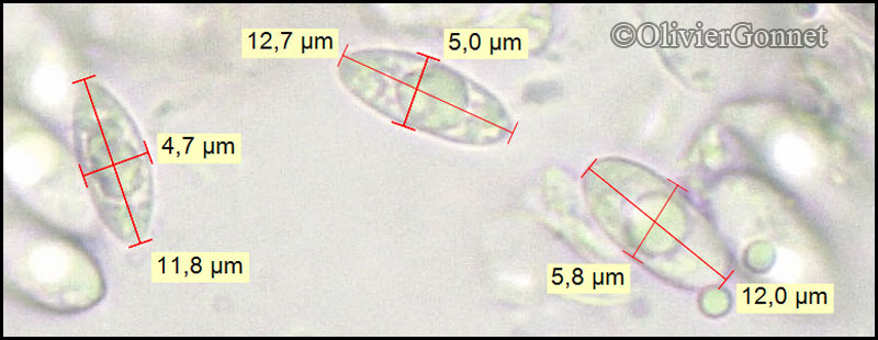
Courtesy Danièle et Olivier Gonnet - Source: https://www.afl-lichenologie.fr/Photos_AFL/Photos_AFL_V/Texte_V/Verrucaria_dolosa.htm
France, 5/5/2018 - Poleymieux-au-Mont-d’Or - Rhöne - (69) - ancienne carrière, alt. 400 m, sur escarpement ombragé de roche calcaire
Courtesy Danièle et Olivier Gonnet - Source: https://www.afl-lichenologie.fr/Photos_AFL/Photos_AFL_V/Texte_V/Verrucaria_dolosa.htm
France, 5/5/2018 - Poleymieux-au-Mont-d’Or - Rhöne - (69) - ancienne carrière, alt. 400 m, sur escarpement ombragé de roche calcaire

Source: Servit, M 1949: Nove nebo mene zname druhy lisejnikove celedi Verrucariaceae. Species Verrucariacearum (Lichenes) novae vel minus cognitae. - Sbornik Narodniho Musea v Praze 5(9): 1-51. Tab.1 - Public Domain