Xanthocarpia lacteoides (Nav.-Ros. & Hladun) Cl. Roux
Bull. Ass. Fr. Lichénologie, 47, 1: 30, 2022. Basionym: Caloplaca lacteoides Nav.-Ros. & Hladún - Bull. Soc. linn. Provence, 47: 156, 1996.
Synonyms:
Distribution:
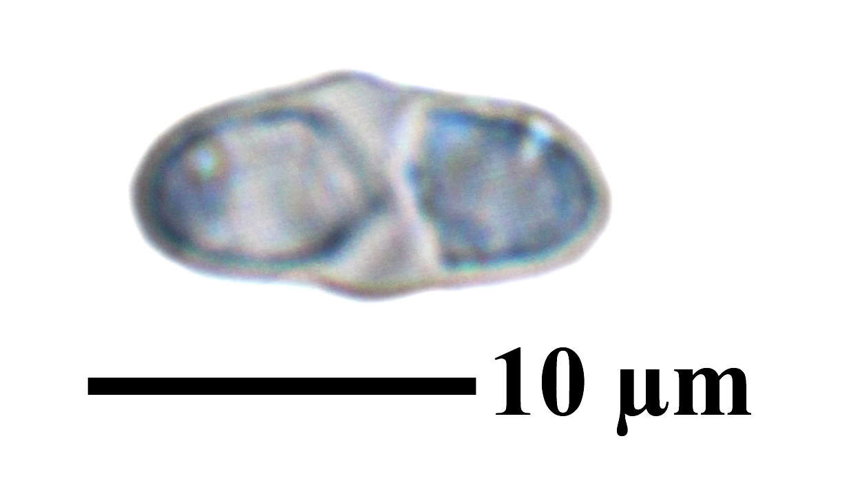
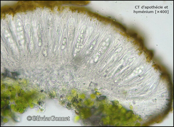
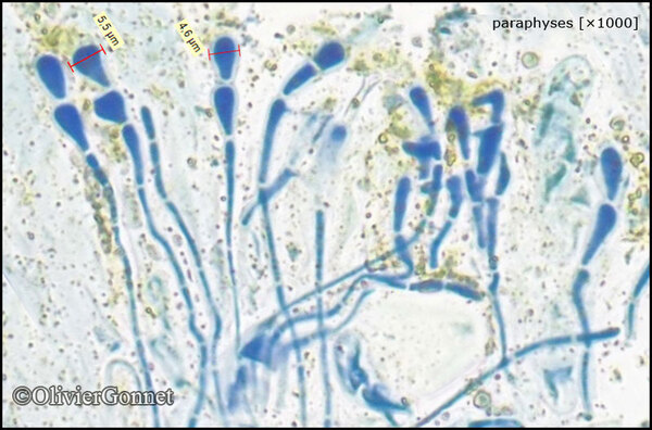
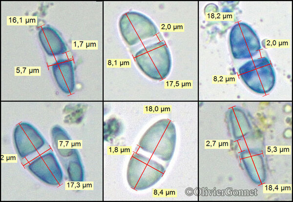
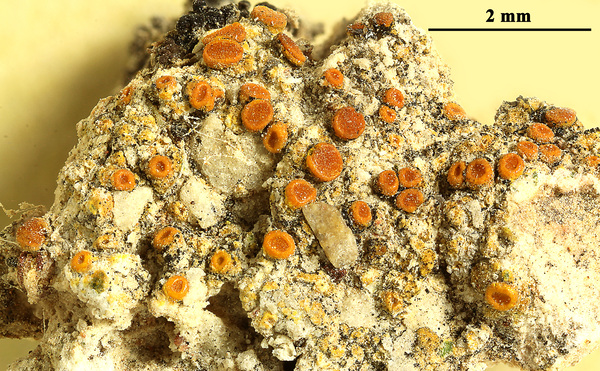
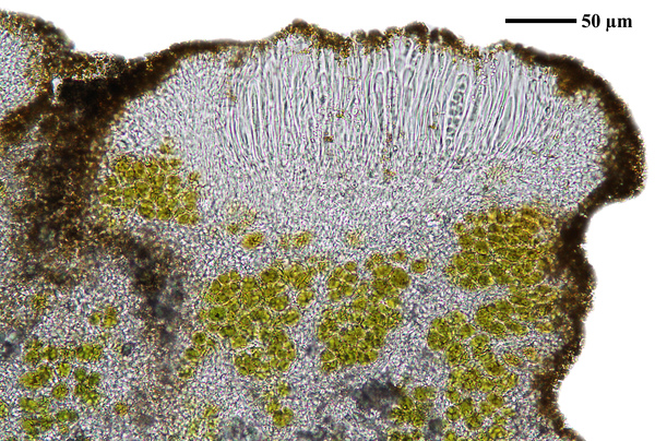
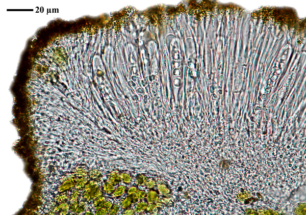
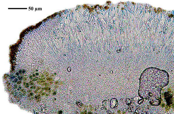
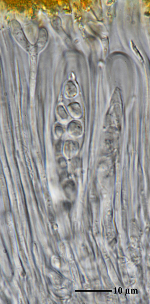
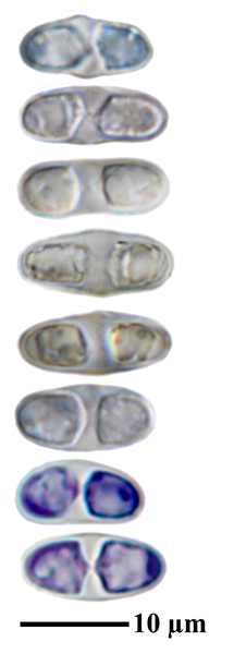
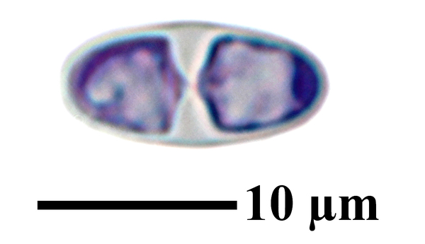
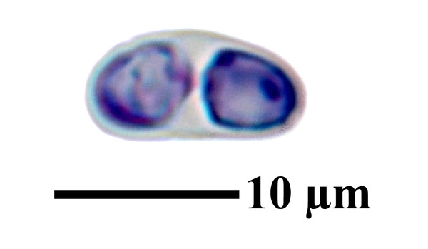
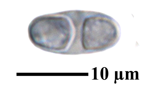
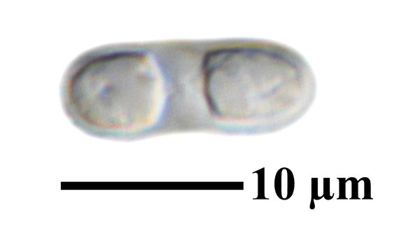
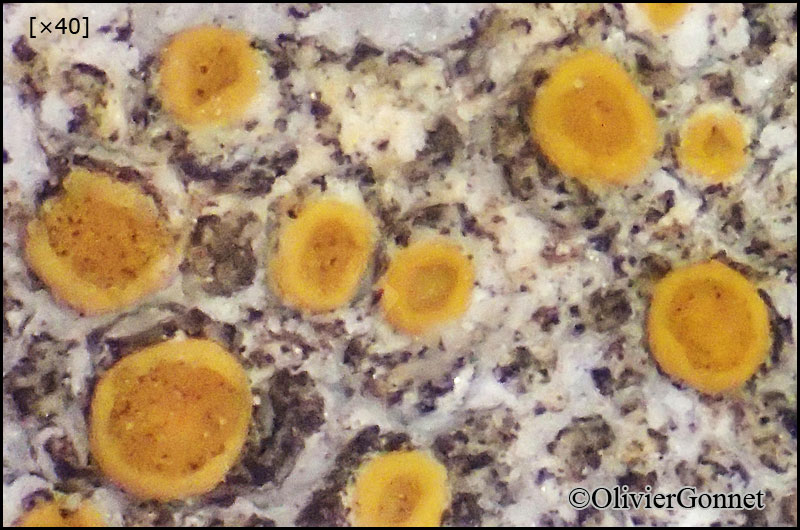
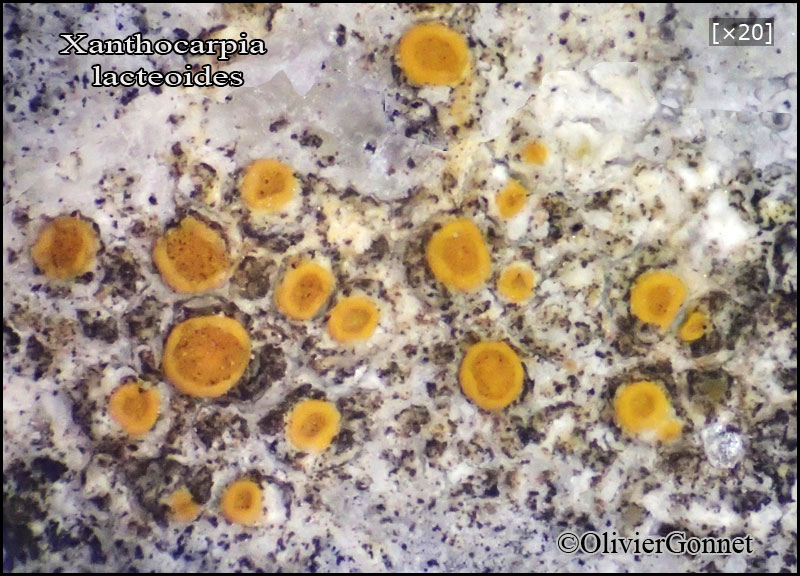
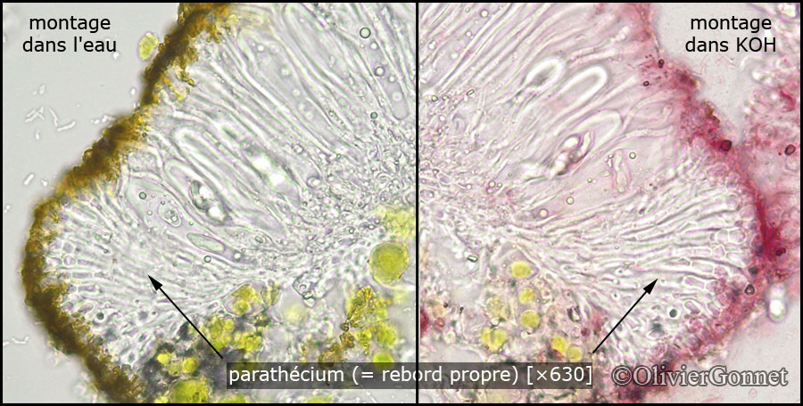
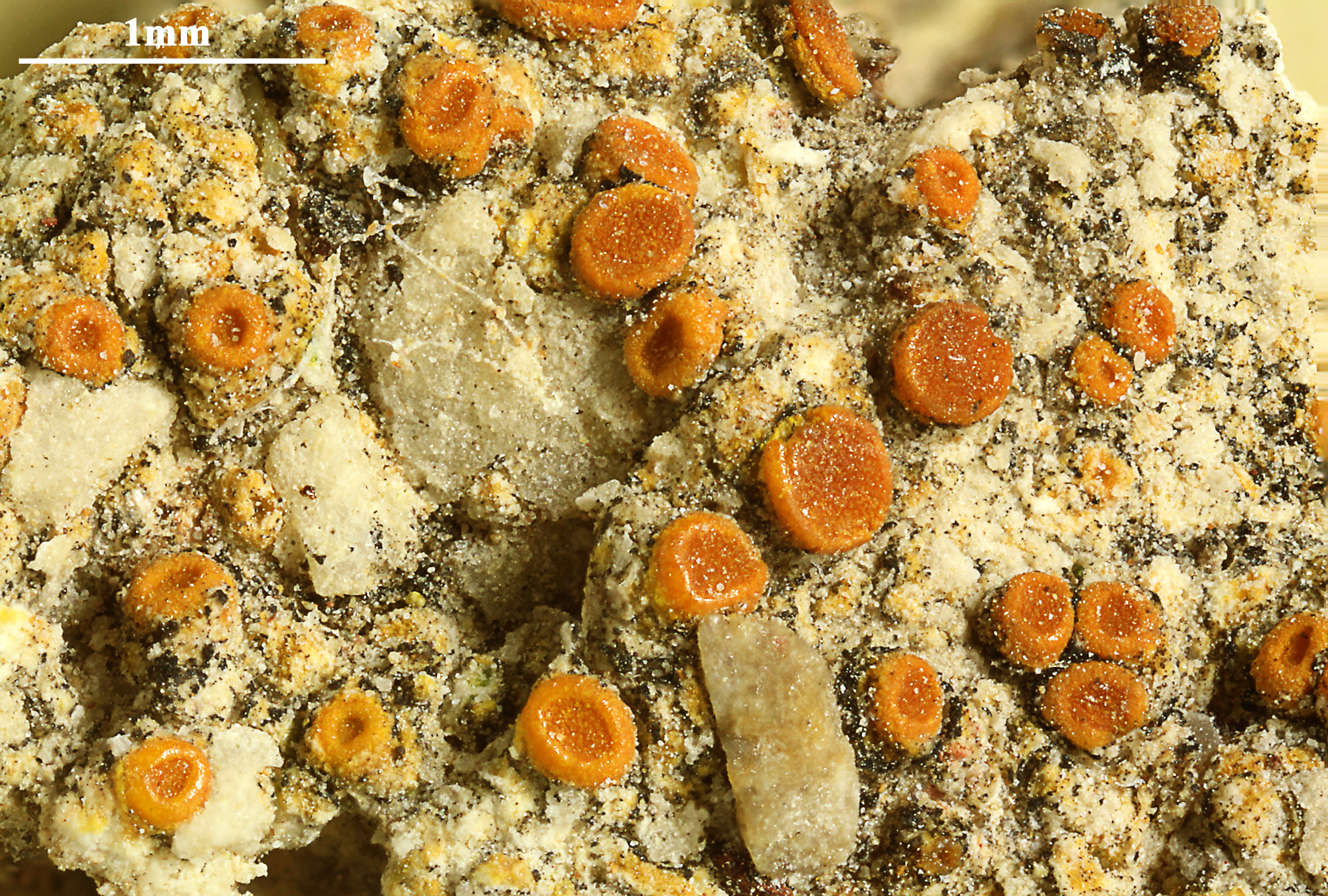
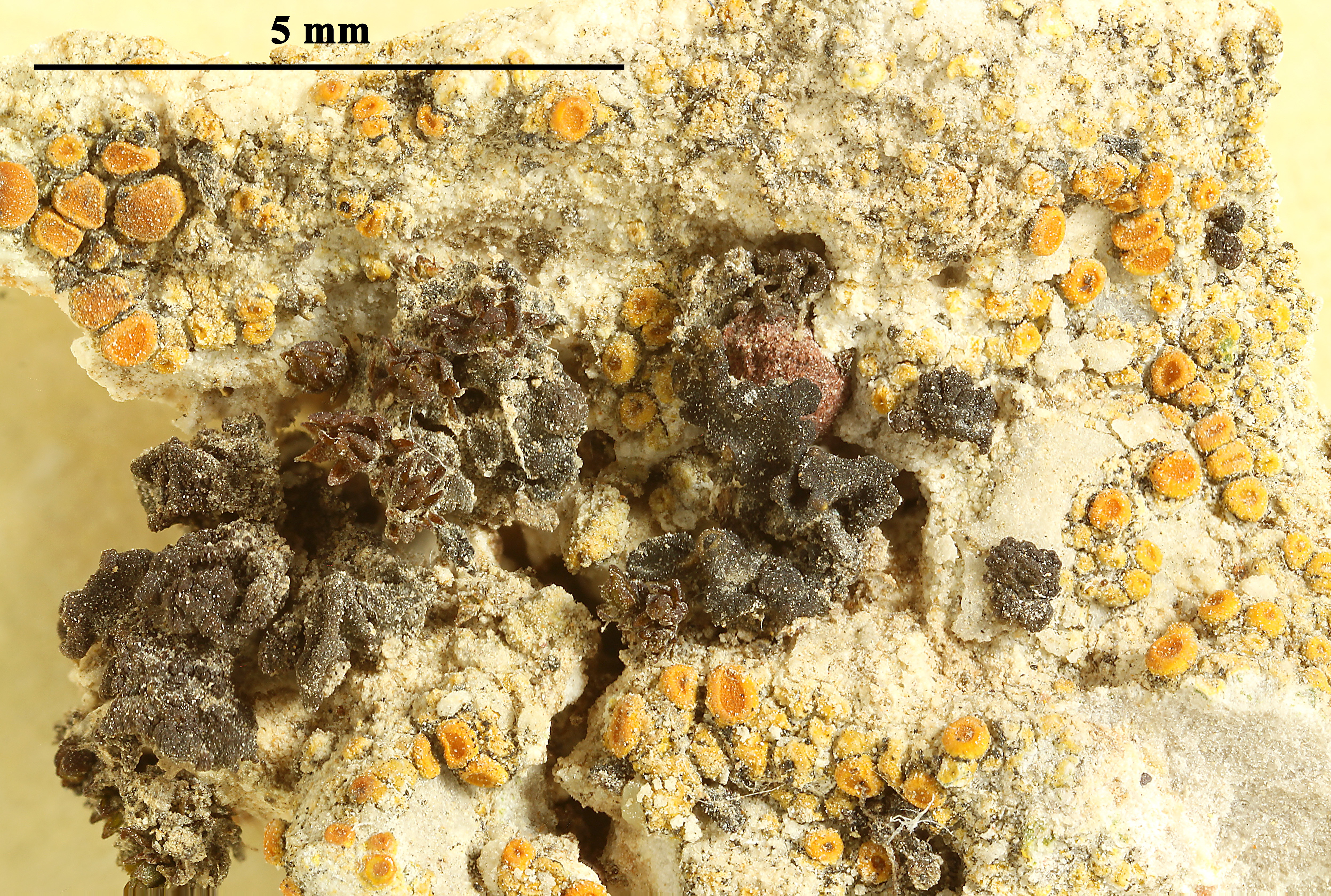
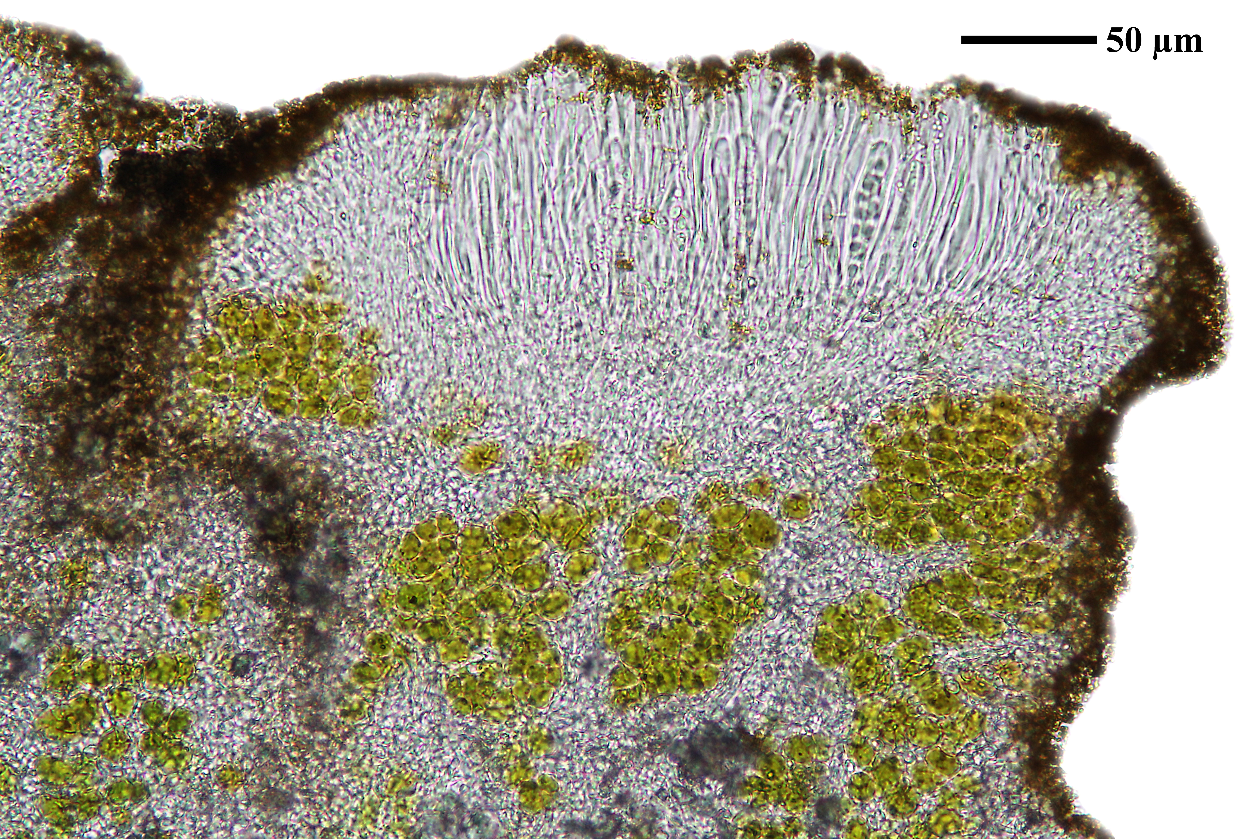
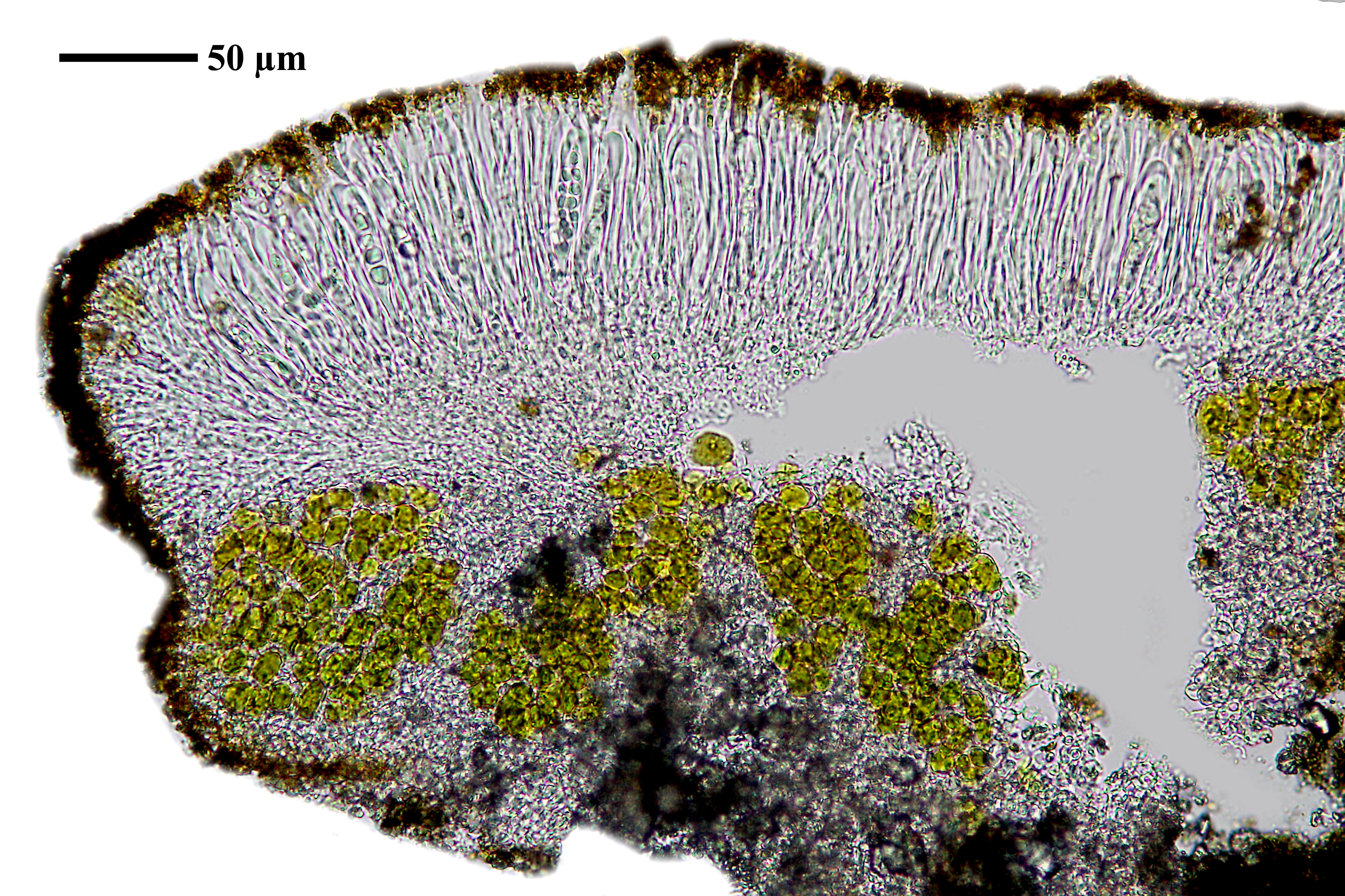
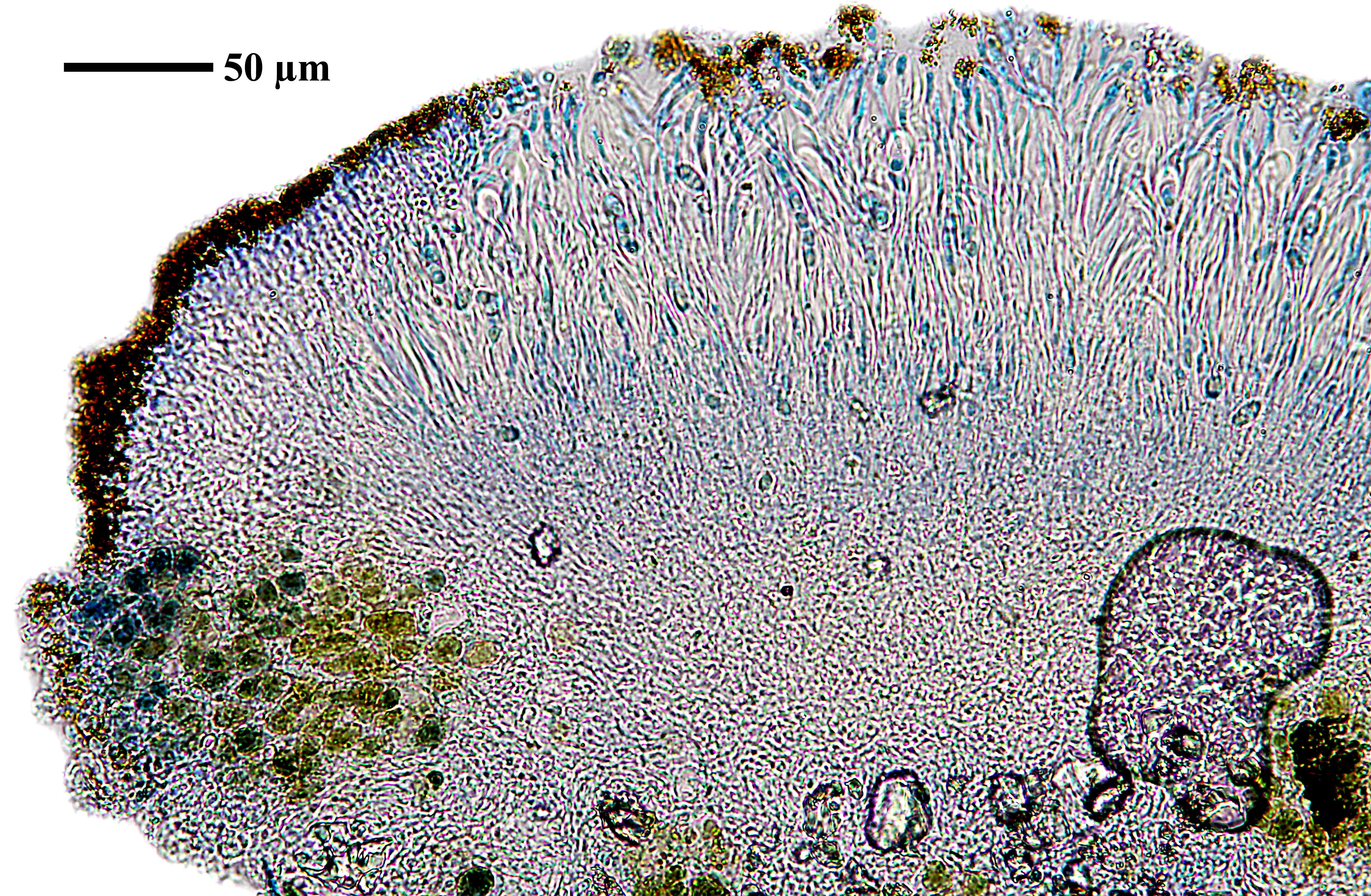
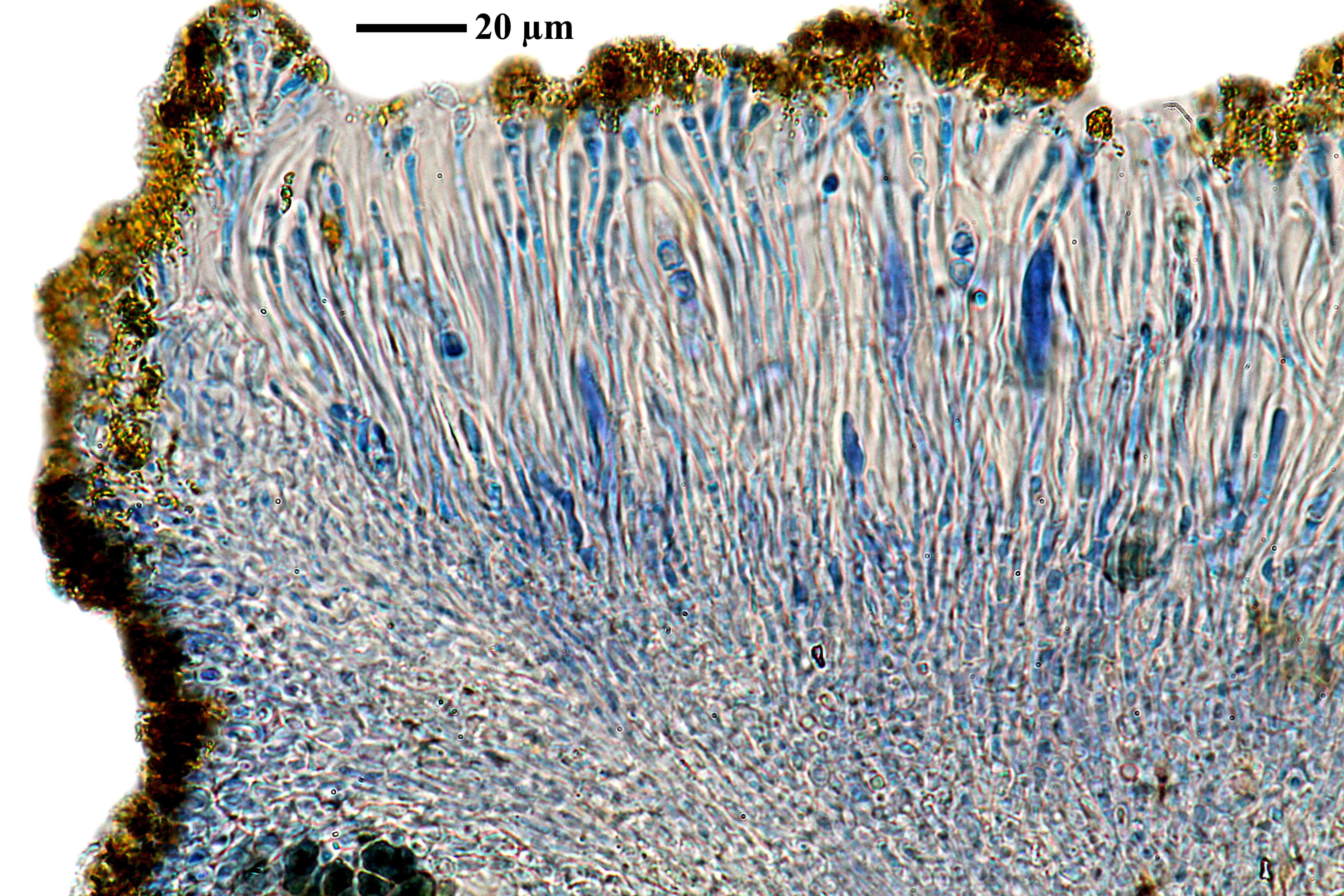
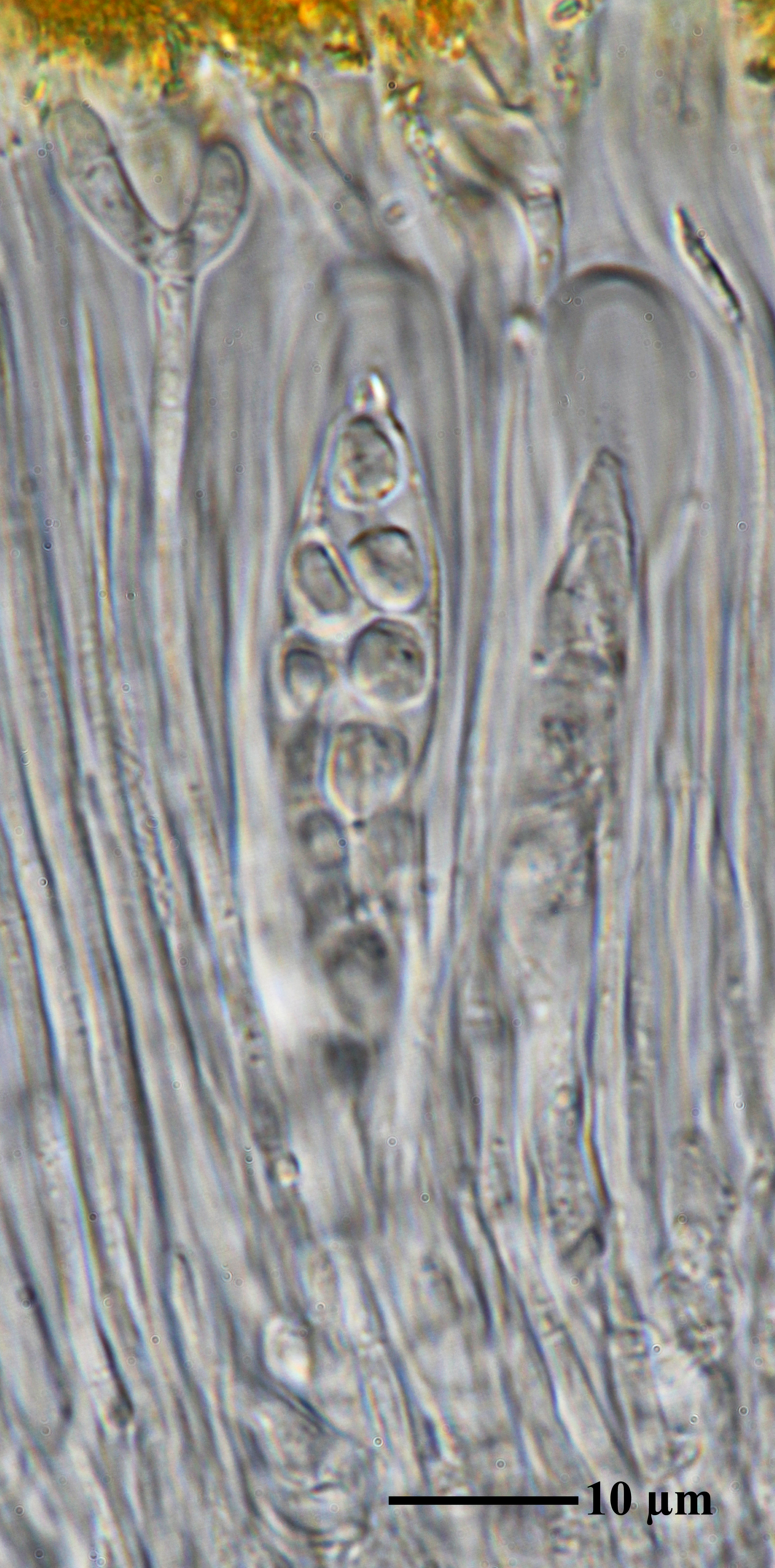
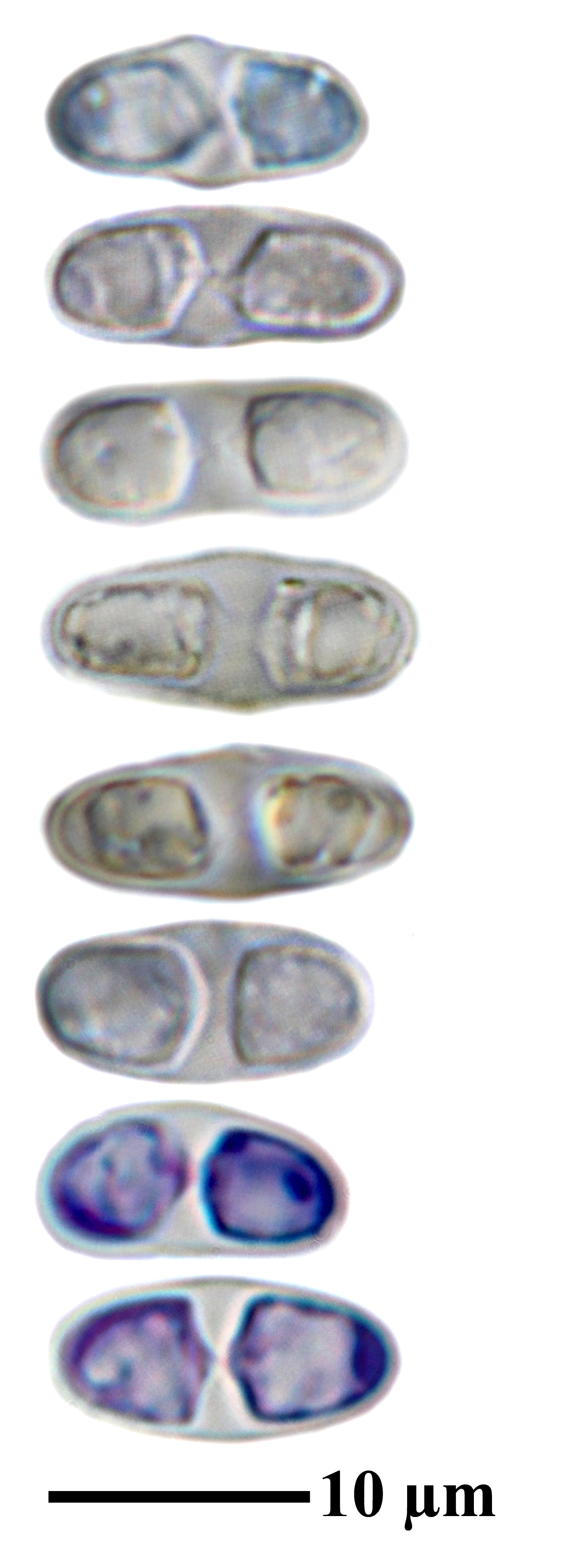
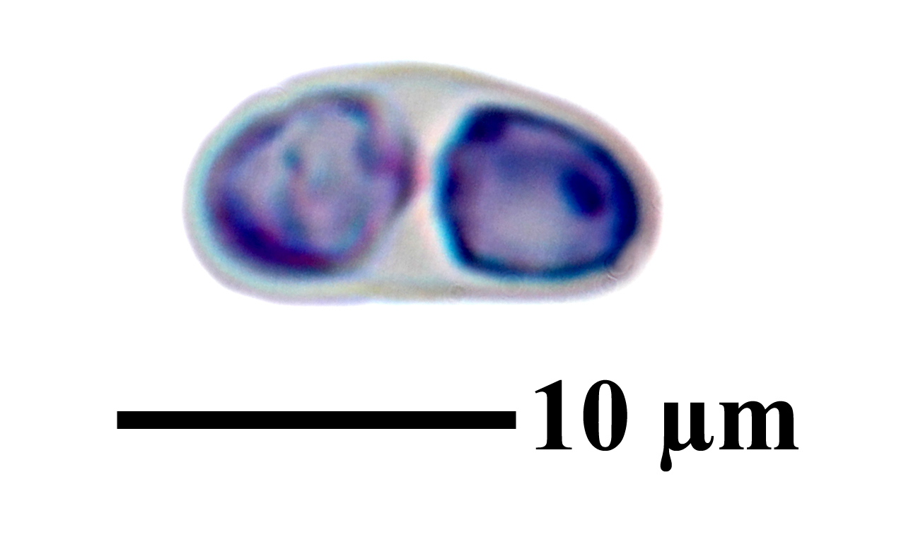
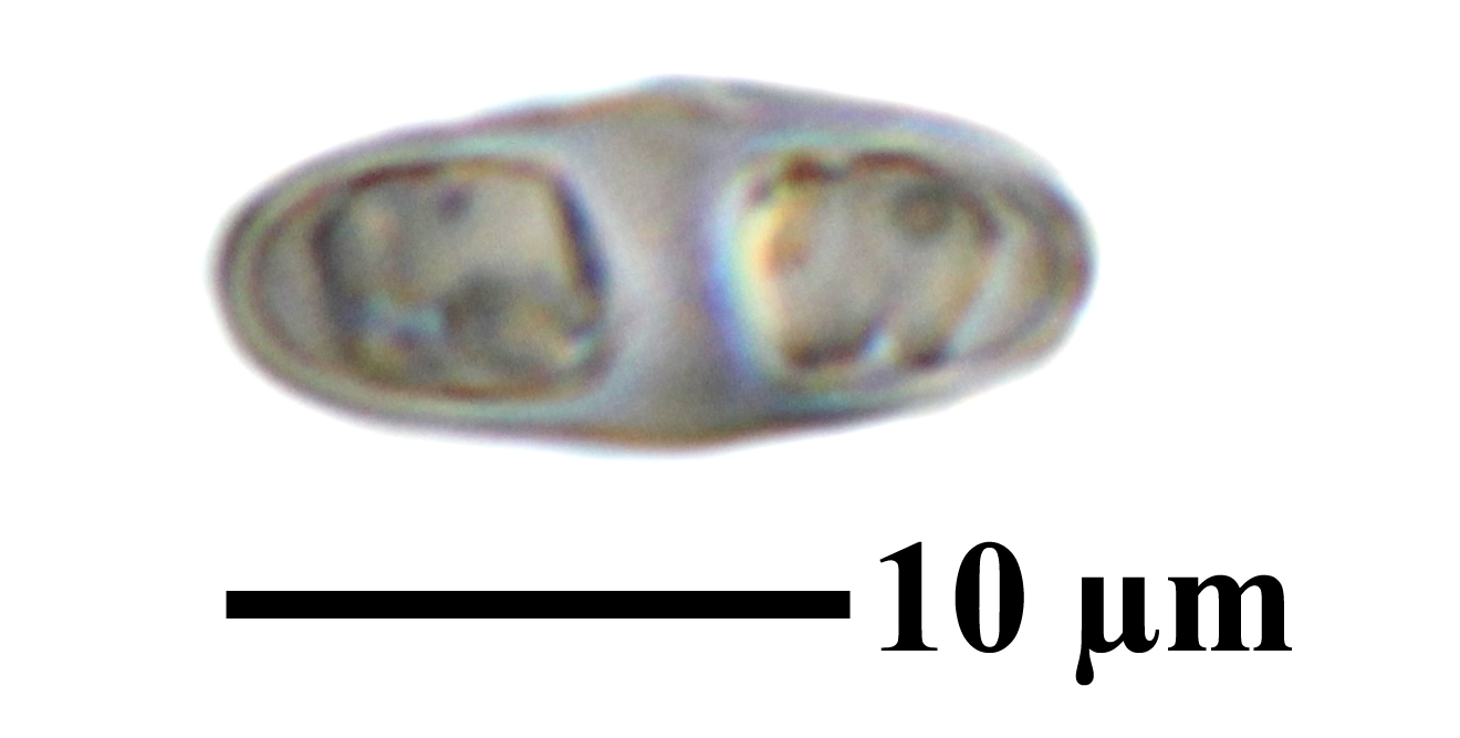
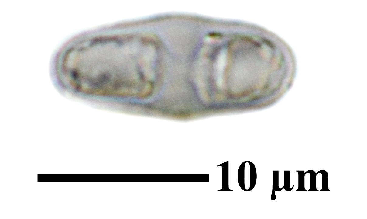
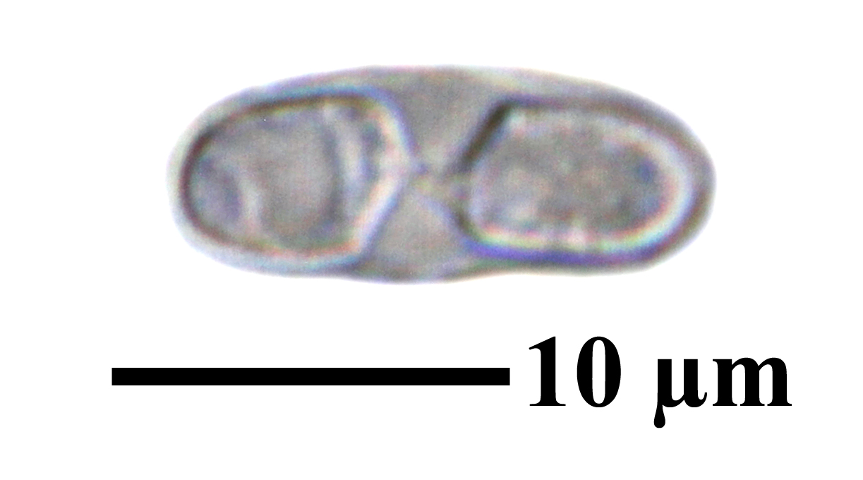
Description: Thallus crustose, endosubstratic, poorly visible, without a distinct prothallus. Apothecia 0.2-0.5 mm across, sessile, usually scattered, with a flat to slightly concave, yellow to ochraceous yellow disc, and a concolorous or slightly paler, rather thin, smooth, persistent proper margin; thalline exciple absent, rarely developed only on the lower part of apothecia. Proper exciple orange and paraplectenchymatous in outermost part, with 6-10 µm wide cells, colourless and prosoplectenchymatous within; epithecium yellow, c. 10 µm thick, K+ red, C-; hymenium colourless, c. 80 µm high; paraphyses simple, c. 2 µm thick at base, capitate, the apical cells globose, up to 9 µm wide; hypothecium colourless. Asci 8-spored, clavate, functionally unitunicate, apically thickened with a broad internal beak, the inner part of apex and external cap I+ blue, Teloschistes-type. Ascospores 2-celled, polarilocular, hyaline, broadly ellipsoid, 16-21(-25) x 5-7 µm, the equatorial thickening (“septum”) 1-2(-2.5) µm. Photobiont chlorococcoid. Spot tests: thallus K-, C-, KC-, P-: apothecia K+ red, C-. Chemistry: thallus without lichen substances; apothecia with parietin (major), fallacinal, emodin, teloschistin and parietinic acid (minor), corresponding with chemosyndrome A of Søchting (1997). Note: usually on calcareous pebbles and low outcrops in Circinaria contorta-communities, but also on concrete; mainly Mediterranean, with some records from the Western Alps. Never reported from Italy, but perhaps confused with other similar species; to be looked for further.
Growth form: Crustose
Substrata: rocks
Photobiont: green algae other than Trentepohlia
Reproductive strategy: mainly sexual
Pioneer species
Commonnes-rarity: (info)
Alpine belt: absent
Subalpine belt: absent
Oromediterranean belt: absent
Montane belt: absent
Submediterranean belt: extremely rare
Padanian area: absent
Humid submediterranean belt: extremely rare
Humid mediterranean belt: extremely rare
Dry mediterranean belt: extremely rare
Predictive model
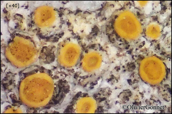
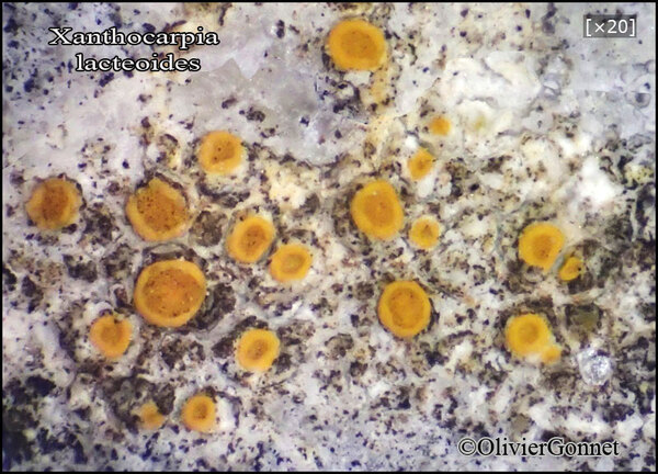
Courtesy Danièle et Olivier Gonnet - Source: https://www.afl-lichenologie.fr/Photos_AFL/Photos_AFL_X/Textes_X1/Xanthocarpia_lacteoides.htm
France, 8/10/2017 - Caussols - Alpes-Maritimes - (06) - sur roche calcaire - sous l'observatoire de la Côte d'Azur, Alt : 1230
Courtesy Danièle et Olivier Gonnet - Source: https://www.afl-lichenologie.fr/Photos_AFL/Photos_AFL_X/Textes_X1/Xanthocarpia_lacteoides.htm
France, 8/10/2017 - Caussols - Alpes-Maritimes - (06) - sur roche calcaire - sous l'observatoire de la Côte d'Azur, Alt : 1230
Courtesy Danièle et Olivier Gonnet - Source: https://www.afl-lichenologie.fr/Photos_AFL/Photos_AFL_X/Textes_X1/Xanthocarpia_lacteoides.htm
France, 8/10/2017 - Caussols - Alpes-Maritimes - (06) - sur roche calcaire - sous l'observatoire de la Côte d'Azur, Alt : 1230

Courtesy Danièle et Olivier Gonnet - Source: https://www.afl-lichenologie.fr/Photos_AFL/Photos_AFL_X/Textes_X1/Xanthocarpia_lacteoides.htm
France, 8/10/2017 - Caussols - Alpes-Maritimes - (06) - sur roche calcaire - sous l'observatoire de la Côte d'Azur, Alt : 1230
Courtesy Danièle et Olivier Gonnet - Source: https://www.afl-lichenologie.fr/Photos_AFL/Photos_AFL_X/Textes_X1/Xanthocarpia_lacteoides.htm
France, 8/10/2017 - Caussols - Alpes-Maritimes - (06) - sur roche calcaire - sous l'observatoire de la Côte d'Azur, Alt : 1230
Courtesy Danièle et Olivier Gonnet - Source: https://www.afl-lichenologie.fr/Photos_AFL/Photos_AFL_X/Textes_X1/Xanthocarpia_lacteoides.htm
France, 8/10/2017 - Caussols - Alpes-Maritimes - (06) - sur roche calcaire - sous l'observatoire de la Côte d'Azur, Alt : 1230


Felix Schumm; Owner: Felix Schumm - CC BY-SA 4.0
[B 60 0133188], Iran, Prov. Kohgiluyeh, c. 35 km from Semirom to Yassuj, on conglomerate stones in Quercus woodland. 30°41' N, 51°21' E, 1600 m. Leg. A. A. Maassoumi & S. R. Safavi, S.R. (2678), 5. November 2003, det. H. Sipman, 2006.

Felix Schumm; Owner: Felix Schumm - CC BY-SA 4.0
[B 60 0133188], Iran, Prov. Kohgiluyeh, c. 35 km from Semirom to Yassuj, on conglomerate stones in Quercus woodland. 30°41' N, 51°21' E, 1600 m. Leg. A. A. Maassoumi & S. R. Safavi, S.R. (2678), 5. November 2003, det. H. Sipman, 2006.
Felix Schumm; Owner: Felix Schumm - CC BY-SA 4.0
[B 60 0133188], Iran, Prov. Kohgiluyeh, c. 35 km from Semirom to Yassuj, on conglomerate stones in Quercus woodland. 30°41' N, 51°21' E, 1600 m. Leg. A. A. Maassoumi & S. R. Safavi, S.R. (2678), 5. November 2003, det. H. Sipman, 2006.
Felix Schumm; Owner: Felix Schumm - CC BY-SA 4.0
[B 60 0133188], Iran, Prov. Kohgiluyeh, c. 35 km from Semirom to Yassuj, on conglomerate stones in Quercus woodland. 30°41' N, 51°21' E, 1600 m. Leg. A. A. Maassoumi & S. R. Safavi, S.R. (2678), 5. November 2003, det. H. Sipman, 2006.

Felix Schumm; Owner: Felix Schumm - CC BY-SA 4.0
[B 60 0133188], Iran, Prov. Kohgiluyeh, c. 35 km from Semirom to Yassuj, on conglomerate stones in Quercus woodland. 30°41' N, 51°21' E, 1600 m. Leg. A. A. Maassoumi & S. R. Safavi, S.R. (2678), 5. November 2003, det. H. Sipman, 2006.
Felix Schumm; Owner: Felix Schumm - CC BY-SA 4.0
[B 60 0133188], Iran, Prov. Kohgiluyeh, c. 35 km from Semirom to Yassuj, on conglomerate stones in Quercus woodland. 30°41' N, 51°21' E, 1600 m. Leg. A. A. Maassoumi & S. R. Safavi, S.R. (2678), 5. November 2003, det. H. Sipman, 2006.
Felix Schumm; Owner: Felix Schumm - CC BY-SA 4.0
[B 60 0133188], Iran, Prov. Kohgiluyeh, c. 35 km from Semirom to Yassuj, on conglomerate stones in Quercus woodland. 30°41' N, 51°21' E, 1600 m. Leg. A. A. Maassoumi & S. R. Safavi, S.R. (2678), 5. November 2003, det. H. Sipman, 2006.

Felix Schumm; Owner: Felix Schumm - CC BY-SA 4.0
[B 60 0133188], Iran, Prov. Kohgiluyeh, c. 35 km from Semirom to Yassuj, on conglomerate stones in Quercus woodland. 30°41' N, 51°21' E, 1600 m. Leg. A. A. Maassoumi & S. R. Safavi, S.R. (2678), 5. November 2003, det. H. Sipman, 2006.

Felix Schumm; Owner: Felix Schumm - CC BY-SA 4.0
[B 60 0133188], Iran, Prov. Kohgiluyeh, c. 35 km from Semirom to Yassuj, on conglomerate stones in Quercus woodland. 30°41' N, 51°21' E, 1600 m. Leg. A. A. Maassoumi & S. R. Safavi, S.R. (2678), 5. November 2003, det. H. Sipman, 2006.
Felix Schumm; Owner: Felix Schumm - CC BY-SA 4.0
[B 60 0133188], Iran, Prov. Kohgiluyeh, c. 35 km from Semirom to Yassuj, on conglomerate stones in Quercus woodland. 30°41' N, 51°21' E, 1600 m. Leg. A. A. Maassoumi & S. R. Safavi, S.R. (2678), 5. November 2003, det. H. Sipman, 2006.
Felix Schumm; Owner: Felix Schumm - CC BY-SA 4.0
[B 60 0133188], Iran, Prov. Kohgiluyeh, c. 35 km from Semirom to Yassuj, on conglomerate stones in Quercus woodland. 30°41' N, 51°21' E, 1600 m. Leg. A. A. Maassoumi & S. R. Safavi, S.R. (2678), 5. November 2003, det. H. Sipman, 2006.
Felix Schumm; Owner: Felix Schumm - CC BY-SA 4.0
[B 60 0133188], Iran, Prov. Kohgiluyeh, c. 35 km from Semirom to Yassuj, on conglomerate stones in Quercus woodland. 30°41' N, 51°21' E, 1600 m. Leg. A. A. Maassoumi & S. R. Safavi, S.R. (2678), 5. November 2003, det. H. Sipman, 2006.
Felix Schumm; Owner: Felix Schumm - CC BY-SA 4.0
[B 60 0133188], Iran, Prov. Kohgiluyeh, c. 35 km from Semirom to Yassuj, on conglomerate stones in Quercus woodland. 30°41' N, 51°21' E, 1600 m. Leg. A. A. Maassoumi & S. R. Safavi, S.R. (2678), 5. November 2003, det. H. Sipman, 2006.
Felix Schumm; Owner: Felix Schumm - CC BY-SA 4.0
[B 60 0133188], Iran, Prov. Kohgiluyeh, c. 35 km from Semirom to Yassuj, on conglomerate stones in Quercus woodland. 30°41' N, 51°21' E, 1600 m. Leg. A. A. Maassoumi & S. R. Safavi, S.R. (2678), 5. November 2003, det. H. Sipman, 2006.

Felix Schumm; Owner: Felix Schumm - CC BY-SA 4.0
[B 60 0133188], Iran, Prov. Kohgiluyeh, c. 35 km from Semirom to Yassuj, on conglomerate stones in Quercus woodland. 30°41' N, 51°21' E, 1600 m. Leg. A. A. Maassoumi & S. R. Safavi, S.R. (2678), 5. November 2003, det. H. Sipman, 2006.

Felix Schumm; Owner: Felix Schumm - CC BY-SA 4.0
[B 60 0133188], Iran, Prov. Kohgiluyeh, c. 35 km from Semirom to Yassuj, on conglomerate stones in Quercus woodland. 30°41' N, 51°21' E, 1600 m. Leg. A. A. Maassoumi & S. R. Safavi, S.R. (2678), 5. November 2003, det. H. Sipman, 2006.
Felix Schumm; Owner: Felix Schumm - CC BY-SA 4.0
[B 60 0133188], Iran, Prov. Kohgiluyeh, c. 35 km from Semirom to Yassuj, on conglomerate stones in Quercus woodland. 30°41' N, 51°21' E, 1600 m. Leg. A. A. Maassoumi & S. R. Safavi, S.R. (2678), 5. November 2003, det. H. Sipman, 2006.

Felix Schumm; Owner: Felix Schumm - CC BY-SA 4.0
[B 60 0133188], Iran, Prov. Kohgiluyeh, c. 35 km from Semirom to Yassuj, on conglomerate stones in Quercus woodland. 30°41' N, 51°21' E, 1600 m. Leg. A. A. Maassoumi & S. R. Safavi, S.R. (2678), 5. November 2003, det. H. Sipman, 2006.

Felix Schumm; Owner: Felix Schumm - CC BY-SA 4.0
[B 60 0133188], Iran, Prov. Kohgiluyeh, c. 35 km from Semirom to Yassuj, on conglomerate stones in Quercus woodland. 30°41' N, 51°21' E, 1600 m. Leg. A. A. Maassoumi & S. R. Safavi, S.R. (2678), 5. November 2003, det. H. Sipman, 2006.
Growth form: Crustose
Substrata: rocks
Photobiont: green algae other than Trentepohlia
Reproductive strategy: mainly sexual
Pioneer species
Commonnes-rarity: (info)
Alpine belt: absent
Subalpine belt: absent
Oromediterranean belt: absent
Montane belt: absent
Submediterranean belt: extremely rare
Padanian area: absent
Humid submediterranean belt: extremely rare
Humid mediterranean belt: extremely rare
Dry mediterranean belt: extremely rare
Predictive model
Courtesy Danièle et Olivier Gonnet - Source: https://www.afl-lichenologie.fr/Photos_AFL/Photos_AFL_X/Textes_X1/Xanthocarpia_lacteoides.htm
France, 8/10/2017 - Caussols - Alpes-Maritimes - (06) - sur roche calcaire - sous l'observatoire de la Côte d'Azur, Alt : 1230
Courtesy Danièle et Olivier Gonnet - Source: https://www.afl-lichenologie.fr/Photos_AFL/Photos_AFL_X/Textes_X1/Xanthocarpia_lacteoides.htm
France, 8/10/2017 - Caussols - Alpes-Maritimes - (06) - sur roche calcaire - sous l'observatoire de la Côte d'Azur, Alt : 1230

Courtesy Danièle et Olivier Gonnet - Source: https://www.afl-lichenologie.fr/Photos_AFL/Photos_AFL_X/Textes_X1/Xanthocarpia_lacteoides.htm
France, 8/10/2017 - Caussols - Alpes-Maritimes - (06) - sur roche calcaire - sous l'observatoire de la Côte d'Azur, Alt : 1230
Courtesy Danièle et Olivier Gonnet - Source: https://www.afl-lichenologie.fr/Photos_AFL/Photos_AFL_X/Textes_X1/Xanthocarpia_lacteoides.htm
France, 8/10/2017 - Caussols - Alpes-Maritimes - (06) - sur roche calcaire - sous l'observatoire de la Côte d'Azur, Alt : 1230

Courtesy Danièle et Olivier Gonnet - Source: https://www.afl-lichenologie.fr/Photos_AFL/Photos_AFL_X/Textes_X1/Xanthocarpia_lacteoides.htm
France, 8/10/2017 - Caussols - Alpes-Maritimes - (06) - sur roche calcaire - sous l'observatoire de la Côte d'Azur, Alt : 1230

Courtesy Danièle et Olivier Gonnet - Source: https://www.afl-lichenologie.fr/Photos_AFL/Photos_AFL_X/Textes_X1/Xanthocarpia_lacteoides.htm
France, 8/10/2017 - Caussols - Alpes-Maritimes - (06) - sur roche calcaire - sous l'observatoire de la Côte d'Azur, Alt : 1230
Felix Schumm; Owner: Felix Schumm - CC BY-SA 4.0
[B 60 0133188], Iran, Prov. Kohgiluyeh, c. 35 km from Semirom to Yassuj, on conglomerate stones in Quercus woodland. 30°41' N, 51°21' E, 1600 m. Leg. A. A. Maassoumi & S. R. Safavi, S.R. (2678), 5. November 2003, det. H. Sipman, 2006.
Felix Schumm; Owner: Felix Schumm - CC BY-SA 4.0
[B 60 0133188], Iran, Prov. Kohgiluyeh, c. 35 km from Semirom to Yassuj, on conglomerate stones in Quercus woodland. 30°41' N, 51°21' E, 1600 m. Leg. A. A. Maassoumi & S. R. Safavi, S.R. (2678), 5. November 2003, det. H. Sipman, 2006.

Felix Schumm; Owner: Felix Schumm - CC BY-SA 4.0
[B 60 0133188], Iran, Prov. Kohgiluyeh, c. 35 km from Semirom to Yassuj, on conglomerate stones in Quercus woodland. 30°41' N, 51°21' E, 1600 m. Leg. A. A. Maassoumi & S. R. Safavi, S.R. (2678), 5. November 2003, det. H. Sipman, 2006.
Felix Schumm; Owner: Felix Schumm - CC BY-SA 4.0
[B 60 0133188], Iran, Prov. Kohgiluyeh, c. 35 km from Semirom to Yassuj, on conglomerate stones in Quercus woodland. 30°41' N, 51°21' E, 1600 m. Leg. A. A. Maassoumi & S. R. Safavi, S.R. (2678), 5. November 2003, det. H. Sipman, 2006.
Felix Schumm; Owner: Felix Schumm - CC BY-SA 4.0
[B 60 0133188], Iran, Prov. Kohgiluyeh, c. 35 km from Semirom to Yassuj, on conglomerate stones in Quercus woodland. 30°41' N, 51°21' E, 1600 m. Leg. A. A. Maassoumi & S. R. Safavi, S.R. (2678), 5. November 2003, det. H. Sipman, 2006.

Felix Schumm; Owner: Felix Schumm - CC BY-SA 4.0
[B 60 0133188], Iran, Prov. Kohgiluyeh, c. 35 km from Semirom to Yassuj, on conglomerate stones in Quercus woodland. 30°41' N, 51°21' E, 1600 m. Leg. A. A. Maassoumi & S. R. Safavi, S.R. (2678), 5. November 2003, det. H. Sipman, 2006.
Felix Schumm; Owner: Felix Schumm - CC BY-SA 4.0
[B 60 0133188], Iran, Prov. Kohgiluyeh, c. 35 km from Semirom to Yassuj, on conglomerate stones in Quercus woodland. 30°41' N, 51°21' E, 1600 m. Leg. A. A. Maassoumi & S. R. Safavi, S.R. (2678), 5. November 2003, det. H. Sipman, 2006.

Felix Schumm; Owner: Felix Schumm - CC BY-SA 4.0
[B 60 0133188], Iran, Prov. Kohgiluyeh, c. 35 km from Semirom to Yassuj, on conglomerate stones in Quercus woodland. 30°41' N, 51°21' E, 1600 m. Leg. A. A. Maassoumi & S. R. Safavi, S.R. (2678), 5. November 2003, det. H. Sipman, 2006.
Felix Schumm; Owner: Felix Schumm - CC BY-SA 4.0
[B 60 0133188], Iran, Prov. Kohgiluyeh, c. 35 km from Semirom to Yassuj, on conglomerate stones in Quercus woodland. 30°41' N, 51°21' E, 1600 m. Leg. A. A. Maassoumi & S. R. Safavi, S.R. (2678), 5. November 2003, det. H. Sipman, 2006.
Felix Schumm; Owner: Felix Schumm - CC BY-SA 4.0
[B 60 0133188], Iran, Prov. Kohgiluyeh, c. 35 km from Semirom to Yassuj, on conglomerate stones in Quercus woodland. 30°41' N, 51°21' E, 1600 m. Leg. A. A. Maassoumi & S. R. Safavi, S.R. (2678), 5. November 2003, det. H. Sipman, 2006.
Felix Schumm; Owner: Felix Schumm - CC BY-SA 4.0
[B 60 0133188], Iran, Prov. Kohgiluyeh, c. 35 km from Semirom to Yassuj, on conglomerate stones in Quercus woodland. 30°41' N, 51°21' E, 1600 m. Leg. A. A. Maassoumi & S. R. Safavi, S.R. (2678), 5. November 2003, det. H. Sipman, 2006.

Felix Schumm; Owner: Felix Schumm - CC BY-SA 4.0
[B 60 0133188], Iran, Prov. Kohgiluyeh, c. 35 km from Semirom to Yassuj, on conglomerate stones in Quercus woodland. 30°41' N, 51°21' E, 1600 m. Leg. A. A. Maassoumi & S. R. Safavi, S.R. (2678), 5. November 2003, det. H. Sipman, 2006.
Felix Schumm; Owner: Felix Schumm - CC BY-SA 4.0
[B 60 0133188], Iran, Prov. Kohgiluyeh, c. 35 km from Semirom to Yassuj, on conglomerate stones in Quercus woodland. 30°41' N, 51°21' E, 1600 m. Leg. A. A. Maassoumi & S. R. Safavi, S.R. (2678), 5. November 2003, det. H. Sipman, 2006.

Felix Schumm; Owner: Felix Schumm - CC BY-SA 4.0
[B 60 0133188], Iran, Prov. Kohgiluyeh, c. 35 km from Semirom to Yassuj, on conglomerate stones in Quercus woodland. 30°41' N, 51°21' E, 1600 m. Leg. A. A. Maassoumi & S. R. Safavi, S.R. (2678), 5. November 2003, det. H. Sipman, 2006.
Felix Schumm; Owner: Felix Schumm - CC BY-SA 4.0
[B 60 0133188], Iran, Prov. Kohgiluyeh, c. 35 km from Semirom to Yassuj, on conglomerate stones in Quercus woodland. 30°41' N, 51°21' E, 1600 m. Leg. A. A. Maassoumi & S. R. Safavi, S.R. (2678), 5. November 2003, det. H. Sipman, 2006.
Felix Schumm; Owner: Felix Schumm - CC BY-SA 4.0
[B 60 0133188], Iran, Prov. Kohgiluyeh, c. 35 km from Semirom to Yassuj, on conglomerate stones in Quercus woodland. 30°41' N, 51°21' E, 1600 m. Leg. A. A. Maassoumi & S. R. Safavi, S.R. (2678), 5. November 2003, det. H. Sipman, 2006.

Felix Schumm; Owner: Felix Schumm - CC BY-SA 4.0
[B 60 0133188], Iran, Prov. Kohgiluyeh, c. 35 km from Semirom to Yassuj, on conglomerate stones in Quercus woodland. 30°41' N, 51°21' E, 1600 m. Leg. A. A. Maassoumi & S. R. Safavi, S.R. (2678), 5. November 2003, det. H. Sipman, 2006.
Felix Schumm; Owner: Felix Schumm - CC BY-SA 4.0
[B 60 0133188], Iran, Prov. Kohgiluyeh, c. 35 km from Semirom to Yassuj, on conglomerate stones in Quercus woodland. 30°41' N, 51°21' E, 1600 m. Leg. A. A. Maassoumi & S. R. Safavi, S.R. (2678), 5. November 2003, det. H. Sipman, 2006.