Anaptychia ulothricoides (Vain.) Vain.
Bot. Tidsskr., 26: 245, 1904. Basionym: Physcia ulothricoides Vain. - Acta Horti Petropolit., 10, 2: 553, 1888.
Synonyms:
Distribution:
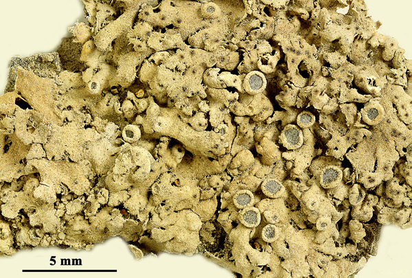
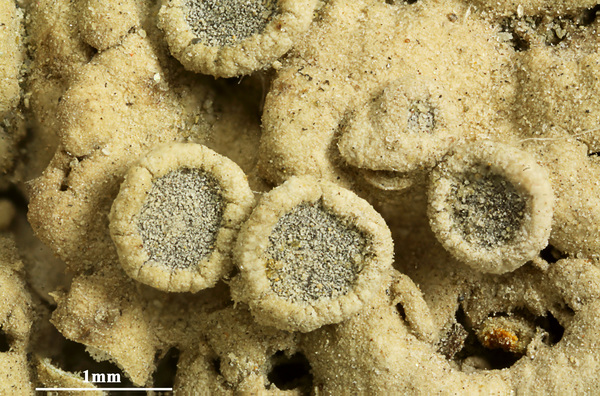
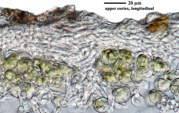
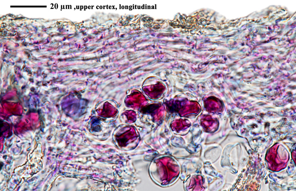
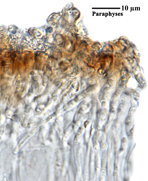
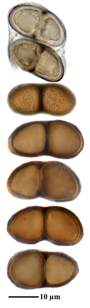
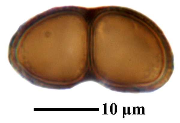
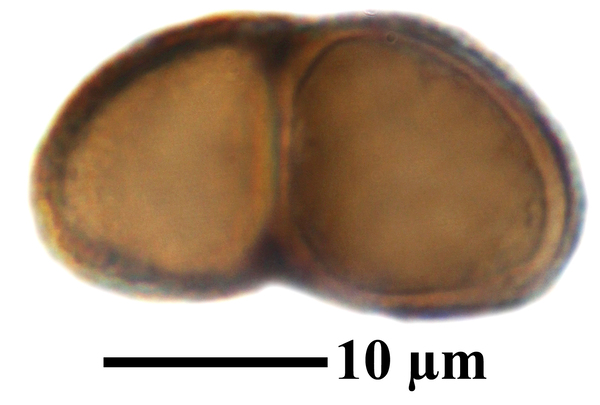
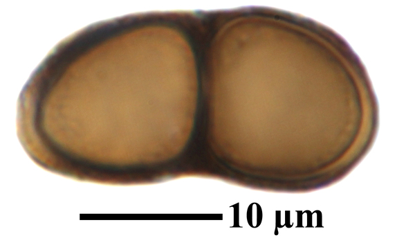
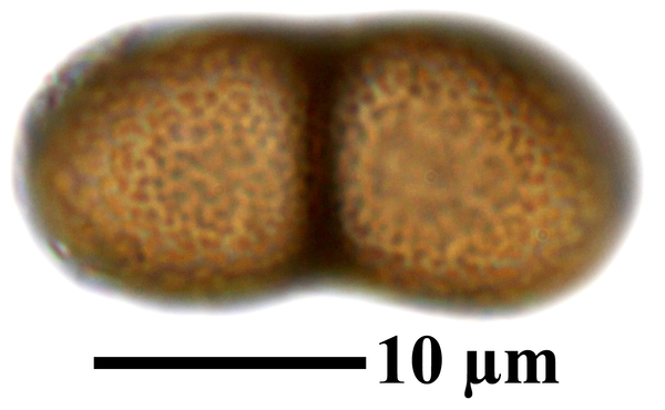
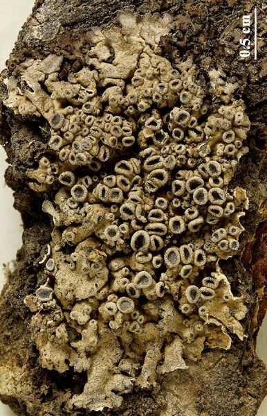
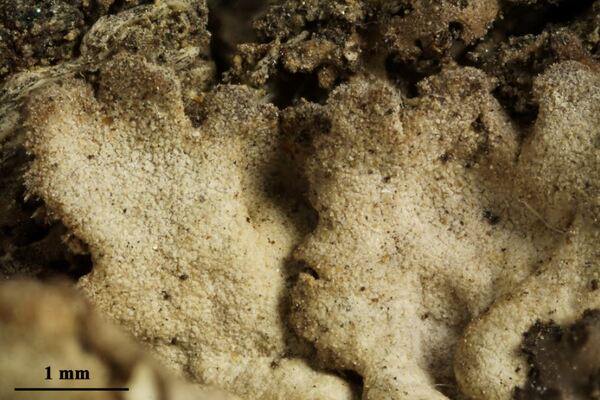
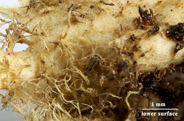
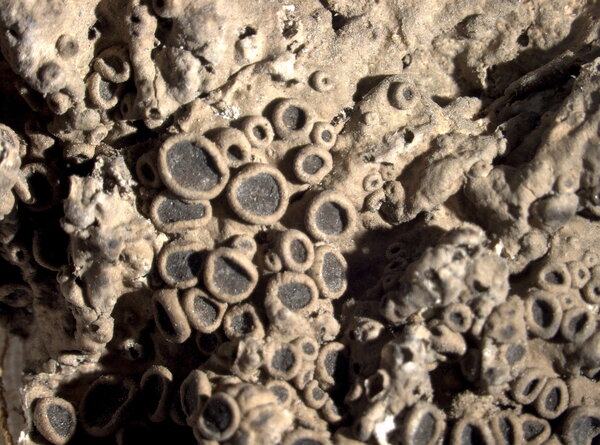
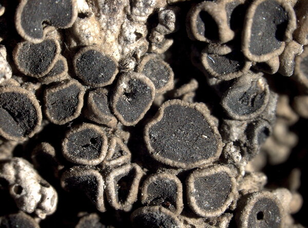
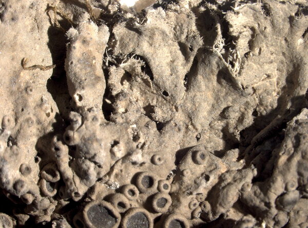
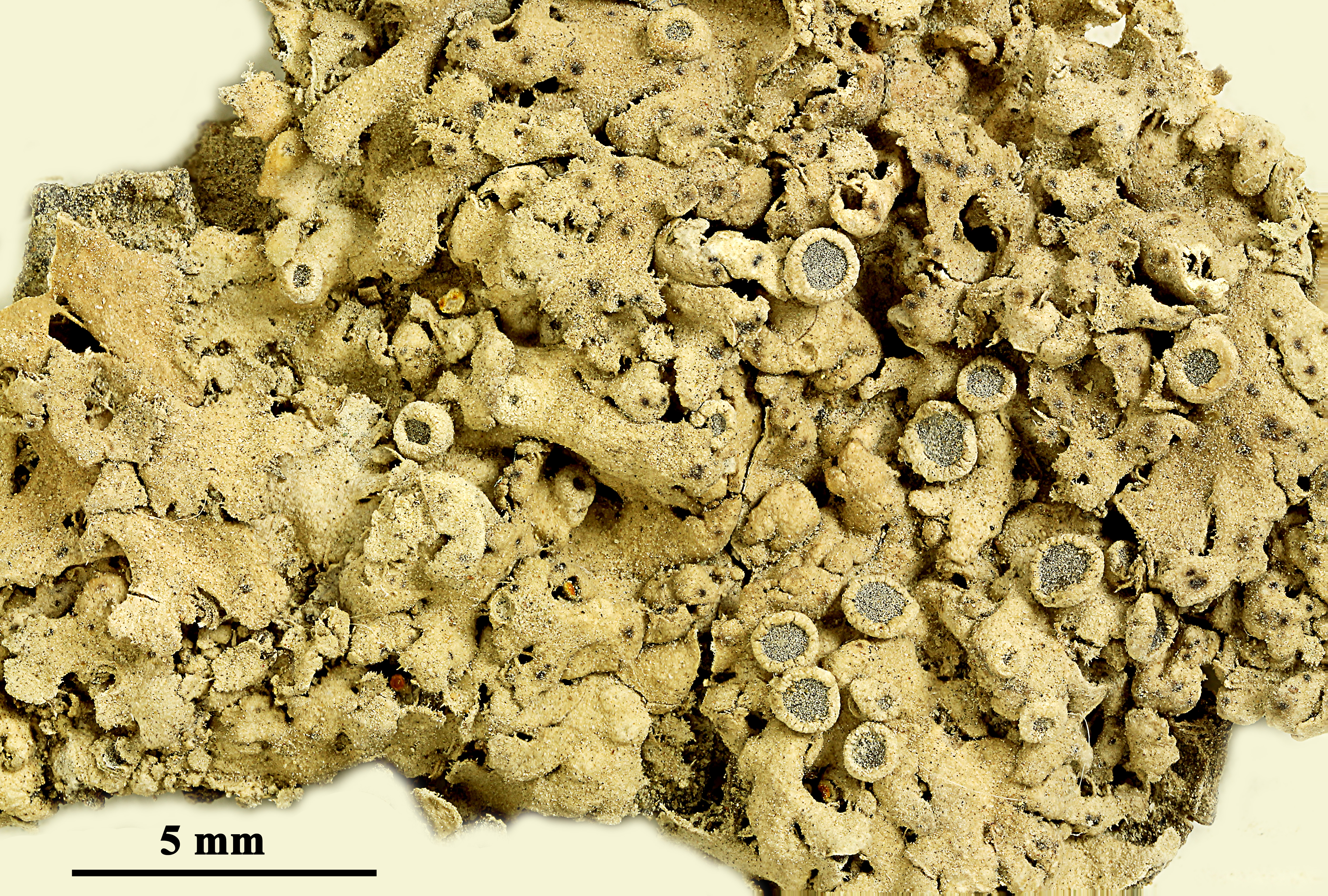
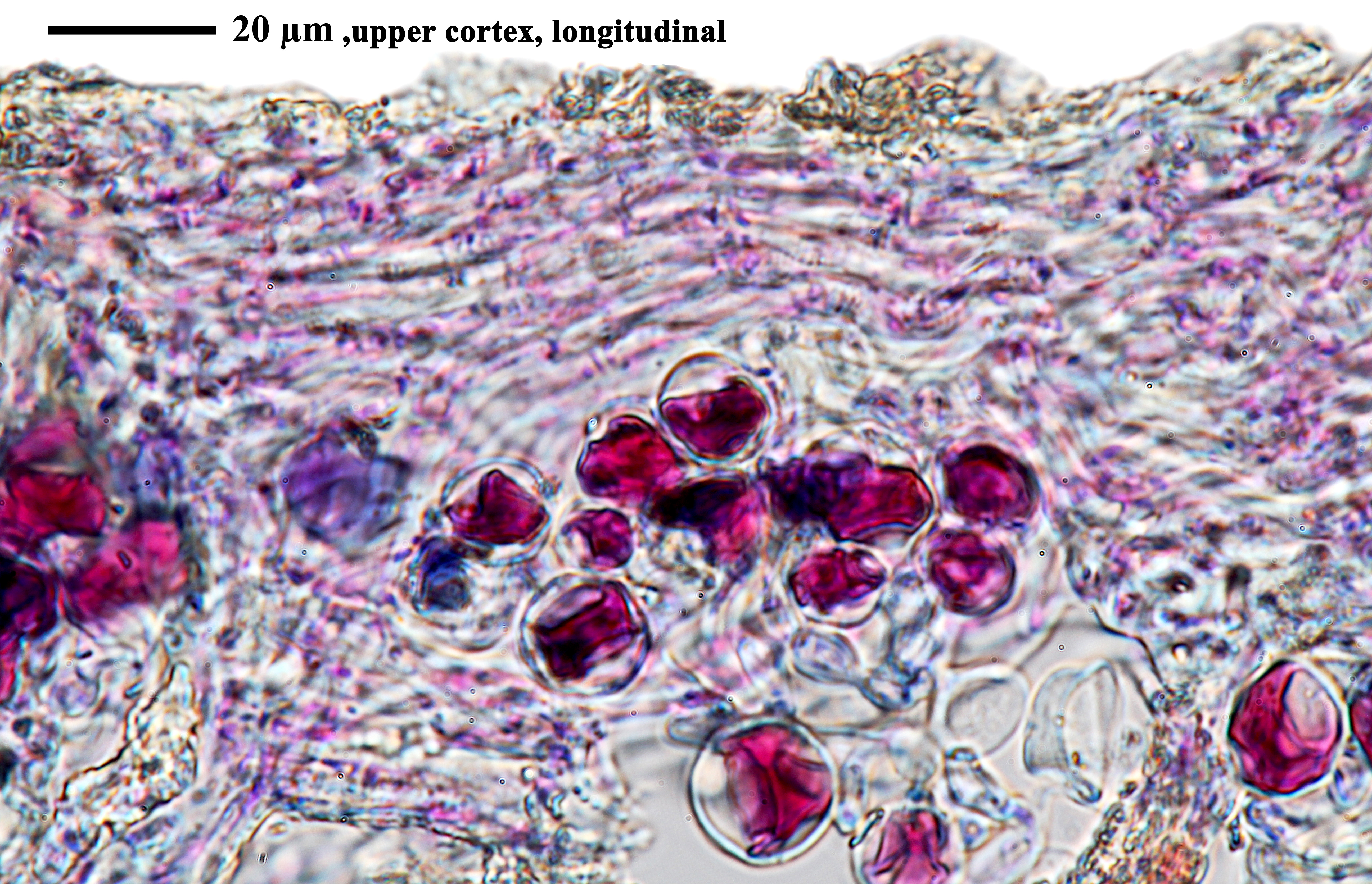
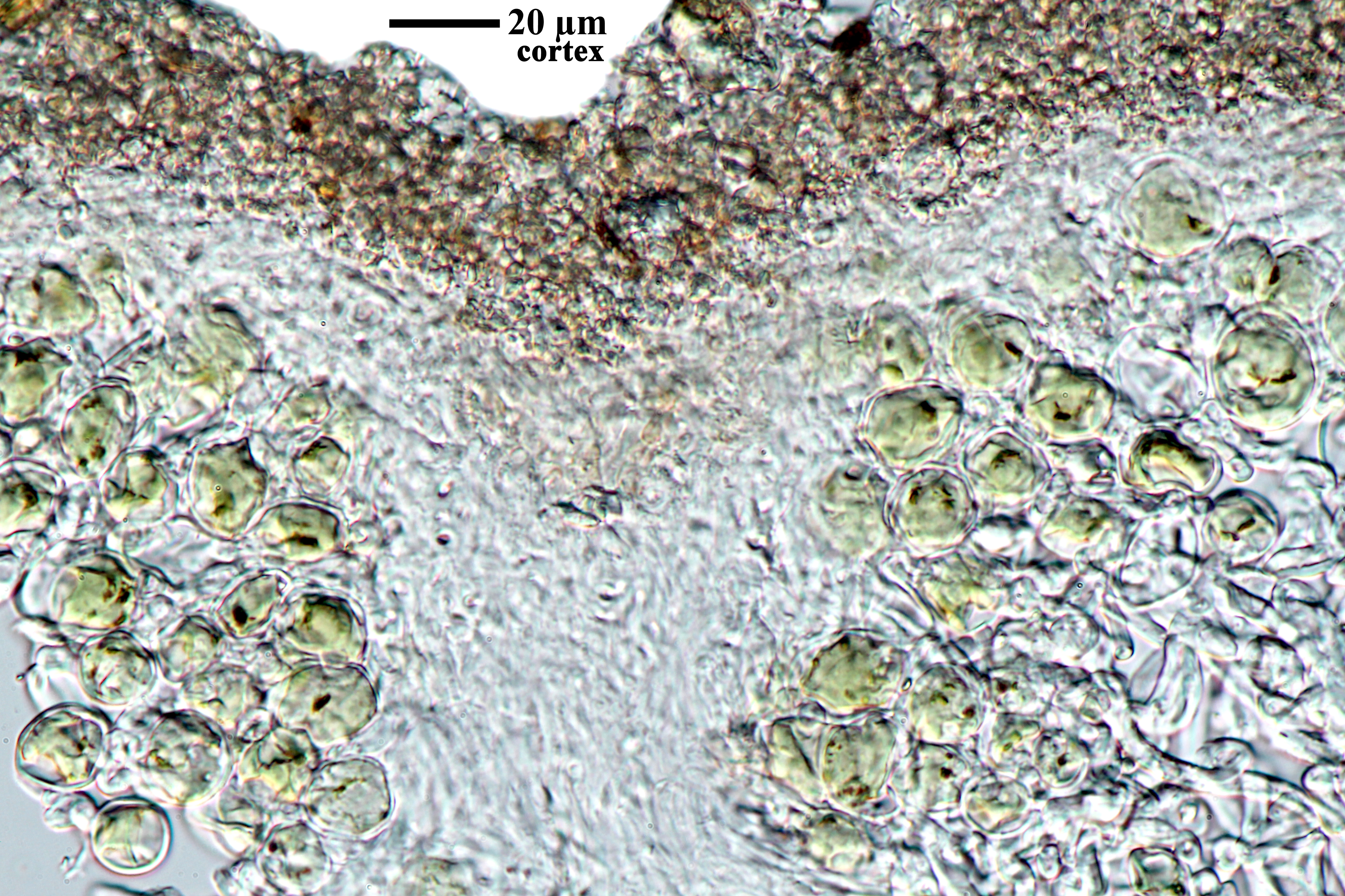
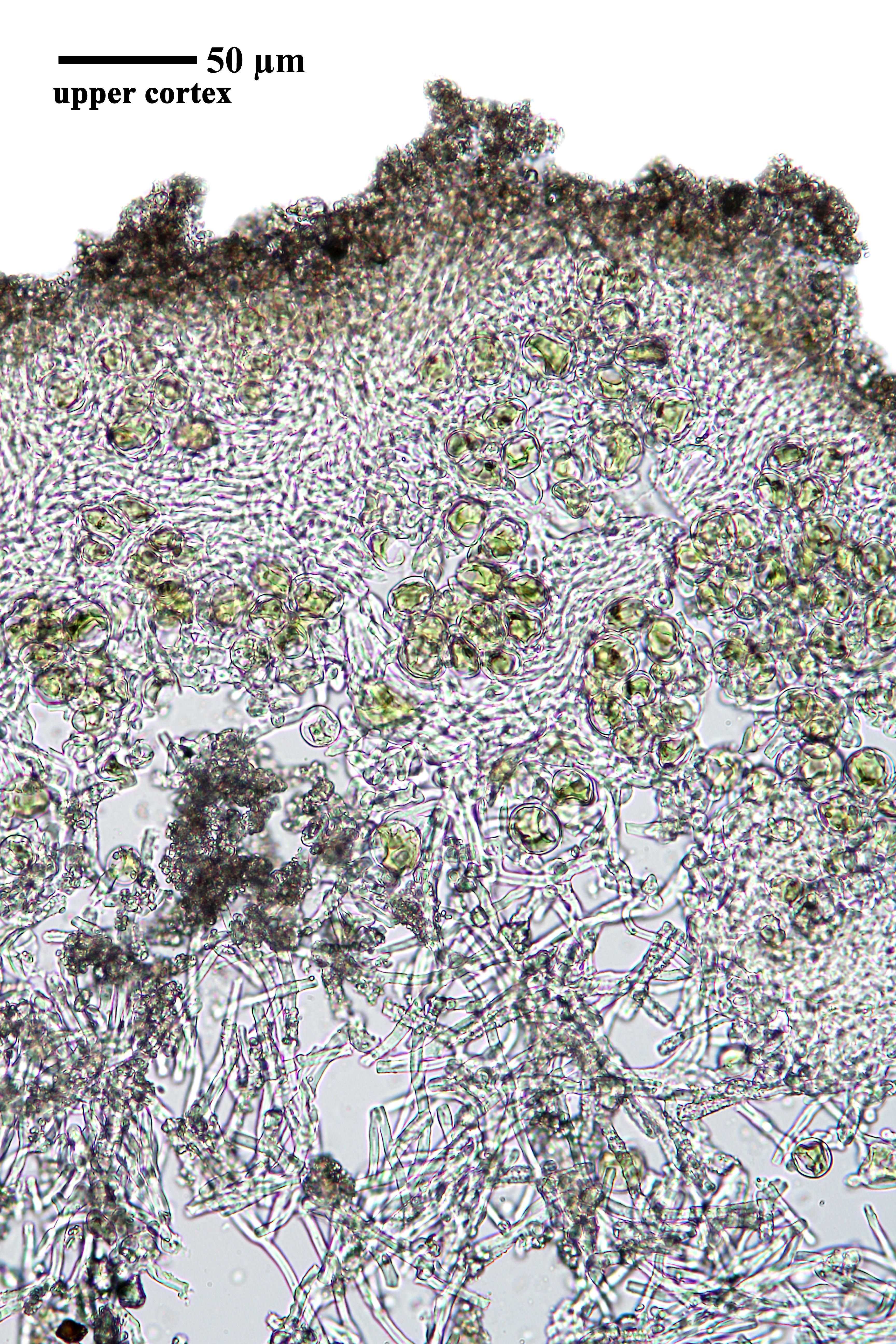
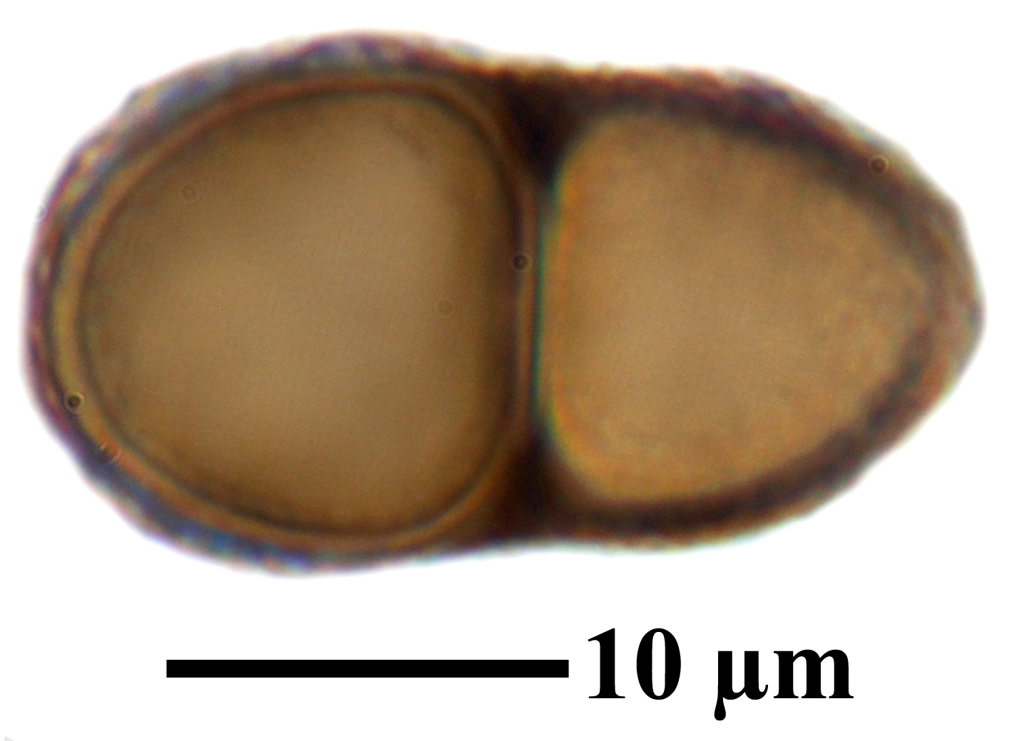
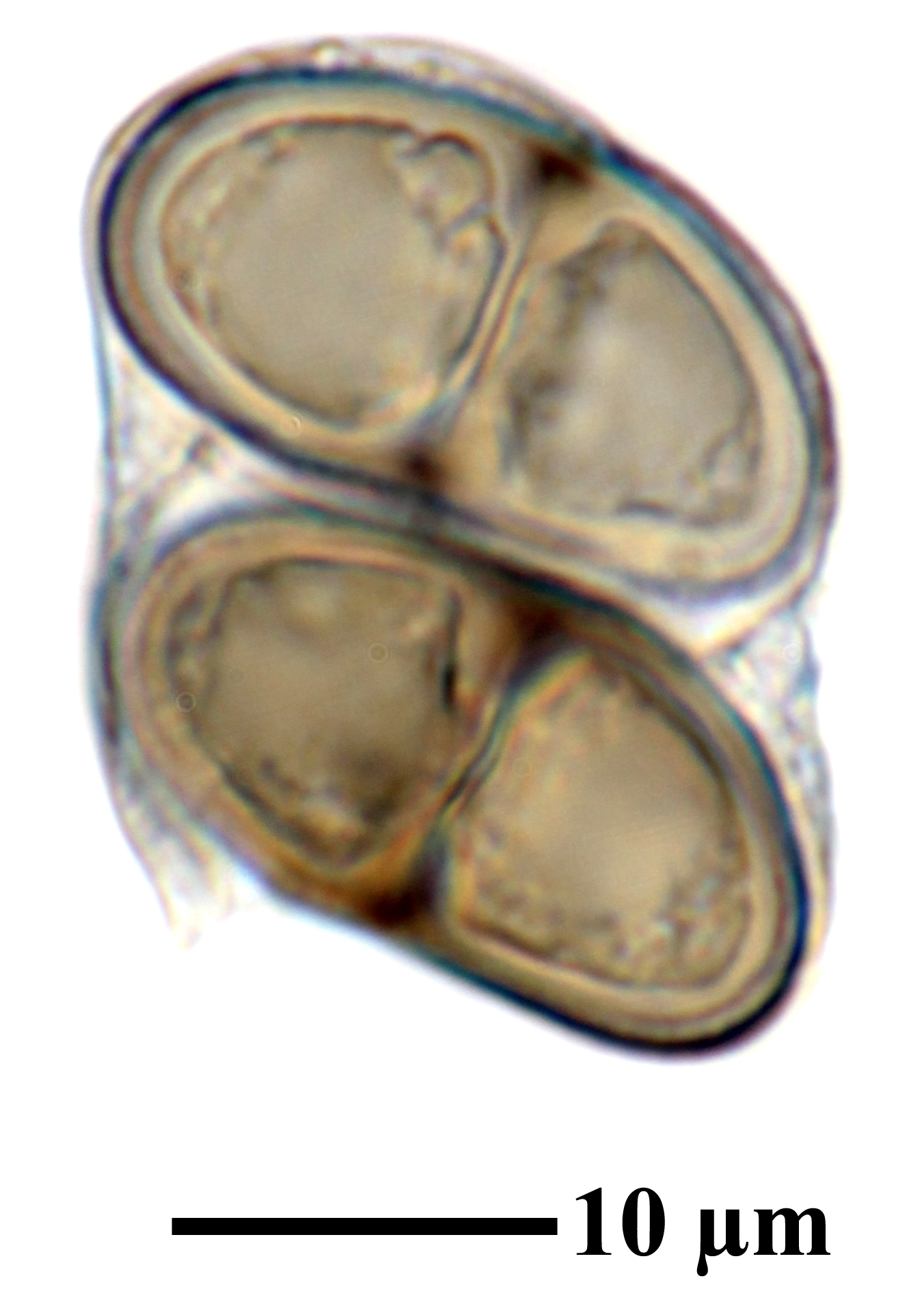
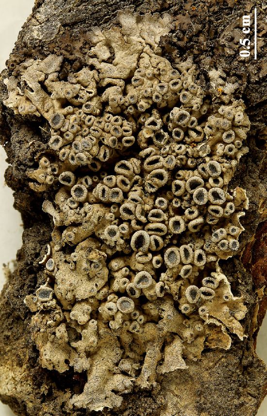
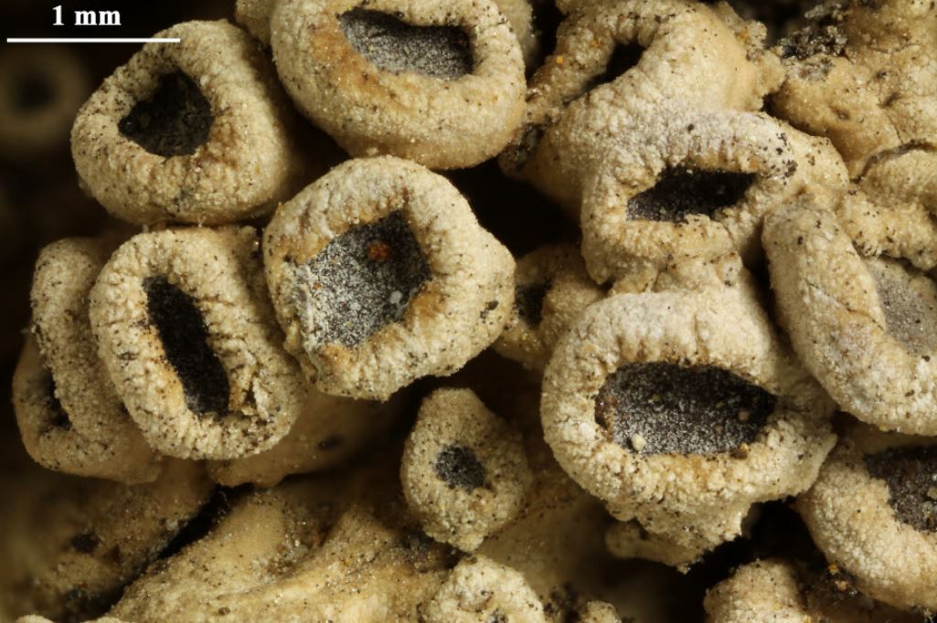
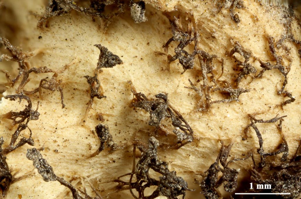
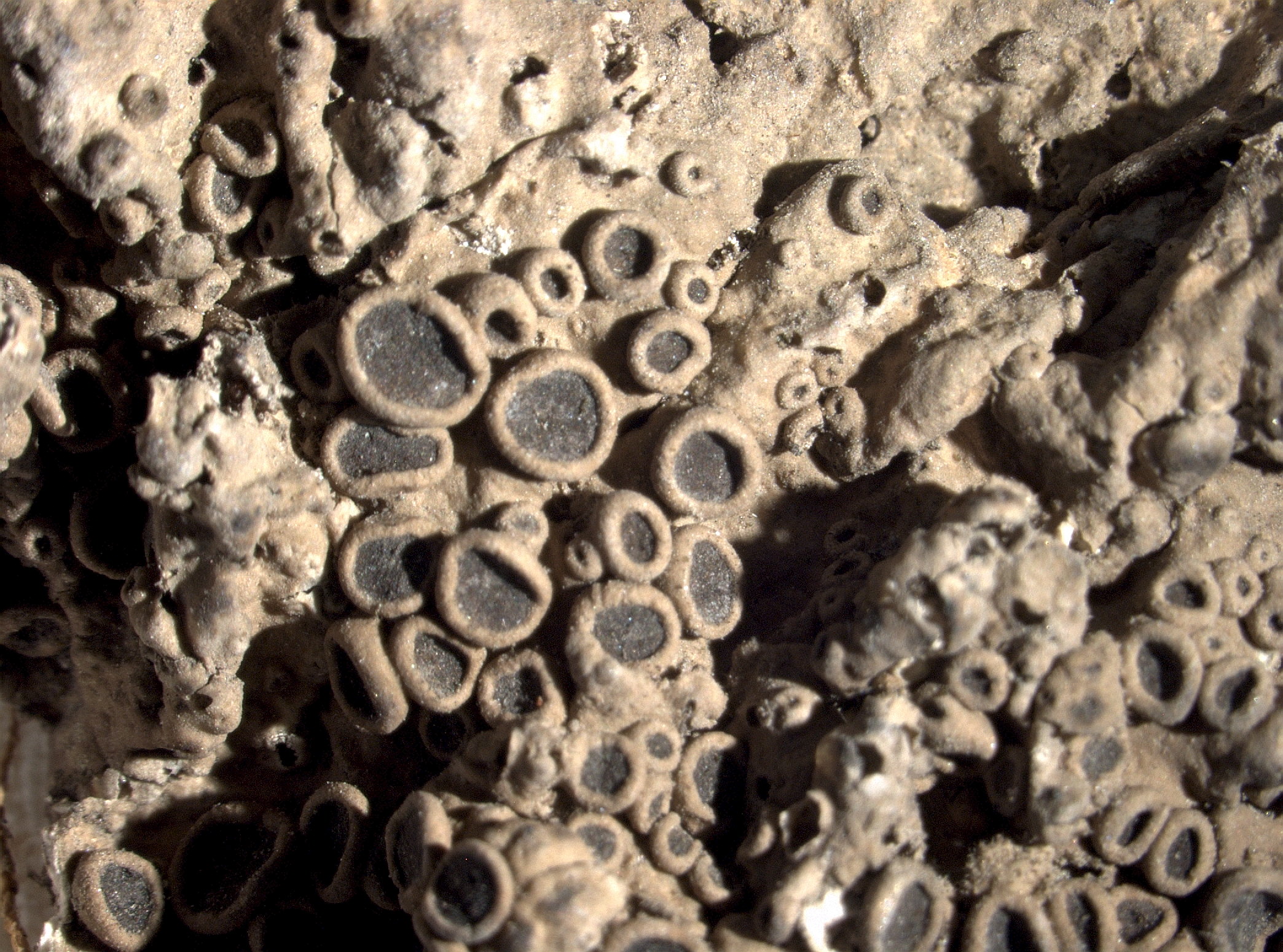
Description: Thallus foliose, irregular to somewhat orbicular, up to 3(-8) cm in diam., the lobes linear, elongate, often somewhat overlapping, 0.3-1 mm broad, flat or weakly convex in older parts, with sparse to rather numerous, short, transparent to finally darkening cortical hairs on or near lobe ends; upper surface dirty white to brown, usually pruinose at least near the lobe ends. Upper cortex prosoplectenchymatous; medulla white; lower surface white to tan, without a well developed cortex, with sparse to moderately dense, simple to furcate, pale, up to 1 mm long rhizines. Apothecia lecanorine, 1-4 mm across, sessile to short-stipitate, with a dark brown to black, initially faintly pruinose disc and a persistent, entire to irregularly crenulate thalline margin. Epithecium brown; hymenium and hypothecium colourless. Asci 8-spored, clavate, the K/I+ blue tholus penetrated by a faintly amyloid apical cushion with parallel or diverging flanks, the wall K/I-, surrounded by a K/I+ blue outer layer, Lecanora-type. Ascospores 1-septate, brown, ellipsoid, constricted at septa, 25-31 x 13-14 µm, Physconia-type. Pycnidia rare, immersed. Conidia bacilliform, 3.5-5 x <1 µm. Photobiont chlorococcoid. Spot tests: cortex and medulla K-, C-, KC-, P-, UV-. Chemistry: without lichen substances or with traces of terpenoids.Note: a mainly epilithic species with a wide distribution in dry areas of the Northern Hemisphere, known from Spain (Sierra Nevada) and also reported from Algeria. To be looked for in the Mediterranean mountains of Italy.
Growth form: Foliose
Substrata: rocks
Photobiont: green algae other than Trentepohlia
Reproductive strategy: mainly sexual
Subcontinental: restricted to areas with a dry-subcontinental climate (e.g. dry Alpine valleys, parts of Mediterranean Italy)
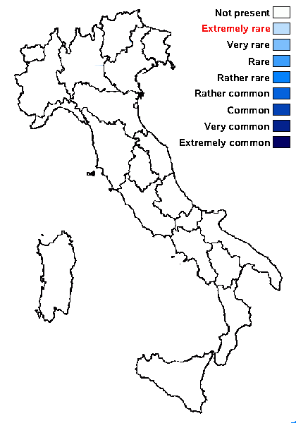
Predictive model

Felix Schumm - CC BY.SA 4.0
[LIAF_06], Afghanistan, Prov. Paktia, Musakhel, an der Straße von Gardez nach Khost. 69°22’ E, 33°26’ N, ca, 2370 m. An Quercus baloot Griff. Leg. M. Steiner (Ste 68), 02.07.1970. LICHENOTHECA AFGHANICA NR. 06.
Felix Schumm - CC BY.SA 4.0
[LIAF_06], Afghanistan, Prov. Paktia, Musakhel, an der Straße von Gardez nach Khost. 69°22’ E, 33°26’ N, ca, 2370 m. An Quercus baloot Griff. Leg. M. Steiner (Ste 68), 02.07.1970. LICHENOTHECA AFGHANICA NR. 06.
Felix Schumm - CC BY.SA 4.0
[LIAF_06], Afghanistan, Prov. Paktia, Musakhel, an der Straße von Gardez nach Khost. 69°22’ E, 33°26’ N, ca, 2370 m. An Quercus baloot Griff. Leg. M. Steiner (Ste 68), 02.07.1970. LICHENOTHECA AFGHANICA NR. 06.
Felix Schumm - CC BY.SA 4.0
[LIAF_06], Afghanistan, Prov. Paktia, Musakhel, an der Straße von Gardez nach Khost. 69°22’ E, 33°26’ N, ca, 2370 m. An Quercus baloot Griff. Leg. M. Steiner (Ste 68), 02.07.1970. LICHENOTHECA AFGHANICA NR. 06.

Felix Schumm - CC BY.SA 4.0
[LIAF_06], Afghanistan, Prov. Paktia, Musakhel, an der Straße von Gardez nach Khost. 69°22’ E, 33°26’ N, ca, 2370 m. An Quercus baloot Griff. Leg. M. Steiner (Ste 68), 02.07.1970. LICHENOTHECA AFGHANICA NR. 06.

Felix Schumm - CC BY.SA 4.0
[LIAF_06], Afghanistan, Prov. Paktia, Musakhel, an der Straße von Gardez nach Khost. 69°22’ E, 33°26’ N, ca, 2370 m. An Quercus baloot Griff. Leg. M. Steiner (Ste 68), 02.07.1970. LICHENOTHECA AFGHANICA NR. 06.
Felix Schumm - CC BY.SA 4.0
[LIAF_06], Afghanistan, Prov. Paktia, Musakhel, an der Straße von Gardez nach Khost. 69°22’ E, 33°26’ N, ca, 2370 m. An Quercus baloot Griff. Leg. M. Steiner (Ste 68), 02.07.1970. LICHENOTHECA AFGHANICA NR. 06.
Felix Schumm - CC BY.SA 4.0
[LIAF_06], Afghanistan, Prov. Paktia, Musakhel, an der Straße von Gardez nach Khost. 69°22’ E, 33°26’ N, ca, 2370 m. An Quercus baloot Griff. Leg. M. Steiner (Ste 68), 02.07.1970. LICHENOTHECA AFGHANICA NR. 06.

Felix Schumm - CC BY.SA 4.0
[LIAF_06], Afghanistan, Prov. Paktia, Musakhel, an der Straße von Gardez nach Khost. 69°22’ E, 33°26’ N, ca, 2370 m. An Quercus baloot Griff. Leg. M. Steiner (Ste 68), 02.07.1970. LICHENOTHECA AFGHANICA NR. 06.
Felix Schumm - CC BY.SA 4.0
[LIAF_06], Afghanistan, Prov. Paktia, Musakhel, an der Straße von Gardez nach Khost. 69°22’ E, 33°26’ N, ca, 2370 m. An Quercus baloot Griff. Leg. M. Steiner (Ste 68), 02.07.1970. LICHENOTHECA AFGHANICA NR. 06.
Felix Schumm - CC BY.SA 4.0
[LIAF_06], Afghanistan, Prov. Paktia, Musakhel, an der Straße von Gardez nach Khost. 69°22’ E, 33°26’ N, ca, 2370 m. An Quercus baloot Griff. Leg. M. Steiner (Ste 68), 02.07.1970. LICHENOTHECA AFGHANICA NR. 06.
Felix Schumm - CC BY.SA 4.0
[LIAF_06], Afghanistan, Prov. Paktia, Musakhel, an der Straße von Gardez nach Khost. 69°22’ E, 33°26’ N, ca, 2370 m. An Quercus baloot Griff. Leg. M. Steiner (Ste 68), 02.07.1970. LICHENOTHECA AFGHANICA NR. 06.
Felix Schumm - CC BY.SA 4.0
[LIAF_06], Afghanistan, Prov. Paktia, Musakhel, an der Straße von Gardez nach Khost. 69°22’ E, 33°26’ N, ca, 2370 m. An Quercus baloot Griff. Leg. M. Steiner (Ste 68), 02.07.1970. LICHENOTHECA AFGHANICA NR. 06.

Felix Schumm - CC BY.SA 4.0
[LIAF_06], Afghanistan, Prov. Paktia, Musakhel, an der Straße von Gardez nach Khost. 69°22’ E, 33°26’ N, ca, 2370 m. An Quercus baloot Griff. Leg. M. Steiner (Ste 68), 02.07.1970. LICHENOTHECA AFGHANICA NR. 06.
Felix Schumm - CC BY-SA 4.0
[LIAF_18], Afghanistan, Prov. Kabul, Siau, 27 km N Kabul, an der Straße nach Charikar, 69°06’ E, 34°42’ N, ca, 1750 m, Alte Nußbäume im bewässerten Park eine Landgutes. Leg. M. Steiner (Ste 30/2), 29.05.1970.

Felix Schumm - CC BY-SA 4.0
[LIAF_18], Afghanistan, Prov. Kabul, Siau, 27 km N Kabul, an der Straße nach Charikar, 69°06’ E, 34°42’ N, ca, 1750 m, Alte Nußbäume im bewässerten Park eine Landgutes. Leg. M. Steiner (Ste 30/2), 29.05.1970.
Felix Schumm - CC BY-SA 4.0
[LIAF_18], Afghanistan, Prov. Kabul, Siau, 27 km N Kabul, an der Straße nach Charikar, 69°06’ E, 34°42’ N, ca, 1750 m, Alte Nußbäume im bewässerten Park eine Landgutes. Leg. M. Steiner (Ste 30/2), 29.05.1970.

Felix Schumm - CC BY-SA 4.0
[LIAF_18], Afghanistan, Prov. Kabul, Siau, 27 km N Kabul, an der Straße nach Charikar, 69°06’ E, 34°42’ N, ca, 1750 m, Alte Nußbäume im bewässerten Park eine Landgutes. Leg. M. Steiner (Ste 30/2), 29.05.1970.
Felix Schumm - CC BY-SA 4.0
[LIAF_18], Afghanistan, Prov. Kabul, Siau, 27 km N Kabul, an der Straße nach Charikar, 69°06’ E, 34°42’ N, ca, 1750 m, Alte Nußbäume im bewässerten Park eine Landgutes. Leg. M. Steiner (Ste 30/2), 29.05.1970.
Pier Luigi Nimis - CC BY-SA 4.0
TSB 5667
Pier Luigi Nimis - CC BY-SA 4.0
TSB 5667
Pier Luigi Nimis - CC BY-SA 4.0
TSB 5667
Growth form: Foliose
Substrata: rocks
Photobiont: green algae other than Trentepohlia
Reproductive strategy: mainly sexual
Subcontinental: restricted to areas with a dry-subcontinental climate (e.g. dry Alpine valleys, parts of Mediterranean Italy)
Predictive model
Felix Schumm - CC BY.SA 4.0
[LIAF_06], Afghanistan, Prov. Paktia, Musakhel, an der Straße von Gardez nach Khost. 69°22’ E, 33°26’ N, ca, 2370 m. An Quercus baloot Griff. Leg. M. Steiner (Ste 68), 02.07.1970. LICHENOTHECA AFGHANICA NR. 06.

Felix Schumm - CC BY.SA 4.0
[LIAF_06], Afghanistan, Prov. Paktia, Musakhel, an der Straße von Gardez nach Khost. 69°22’ E, 33°26’ N, ca, 2370 m. An Quercus baloot Griff. Leg. M. Steiner (Ste 68), 02.07.1970. LICHENOTHECA AFGHANICA NR. 06.

Felix Schumm - CC BY.SA 4.0
[LIAF_06], Afghanistan, Prov. Paktia, Musakhel, an der Straße von Gardez nach Khost. 69°22’ E, 33°26’ N, ca, 2370 m. An Quercus baloot Griff. Leg. M. Steiner (Ste 68), 02.07.1970. LICHENOTHECA AFGHANICA NR. 06.
Felix Schumm - CC BY.SA 4.0
[LIAF_06], Afghanistan, Prov. Paktia, Musakhel, an der Straße von Gardez nach Khost. 69°22’ E, 33°26’ N, ca, 2370 m. An Quercus baloot Griff. Leg. M. Steiner (Ste 68), 02.07.1970. LICHENOTHECA AFGHANICA NR. 06.
Felix Schumm - CC BY.SA 4.0
[LIAF_06], Afghanistan, Prov. Paktia, Musakhel, an der Straße von Gardez nach Khost. 69°22’ E, 33°26’ N, ca, 2370 m. An Quercus baloot Griff. Leg. M. Steiner (Ste 68), 02.07.1970. LICHENOTHECA AFGHANICA NR. 06.
Felix Schumm - CC BY.SA 4.0
[LIAF_06], Afghanistan, Prov. Paktia, Musakhel, an der Straße von Gardez nach Khost. 69°22’ E, 33°26’ N, ca, 2370 m. An Quercus baloot Griff. Leg. M. Steiner (Ste 68), 02.07.1970. LICHENOTHECA AFGHANICA NR. 06.

Felix Schumm - CC BY.SA 4.0
[LIAF_06], Afghanistan, Prov. Paktia, Musakhel, an der Straße von Gardez nach Khost. 69°22’ E, 33°26’ N, ca, 2370 m. An Quercus baloot Griff. Leg. M. Steiner (Ste 68), 02.07.1970. LICHENOTHECA AFGHANICA NR. 06.

Felix Schumm - CC BY.SA 4.0
[LIAF_06], Afghanistan, Prov. Paktia, Musakhel, an der Straße von Gardez nach Khost. 69°22’ E, 33°26’ N, ca, 2370 m. An Quercus baloot Griff. Leg. M. Steiner (Ste 68), 02.07.1970. LICHENOTHECA AFGHANICA NR. 06.
Felix Schumm - CC BY.SA 4.0
[LIAF_06], Afghanistan, Prov. Paktia, Musakhel, an der Straße von Gardez nach Khost. 69°22’ E, 33°26’ N, ca, 2370 m. An Quercus baloot Griff. Leg. M. Steiner (Ste 68), 02.07.1970. LICHENOTHECA AFGHANICA NR. 06.

Felix Schumm - CC BY.SA 4.0
[LIAF_06], Afghanistan, Prov. Paktia, Musakhel, an der Straße von Gardez nach Khost. 69°22’ E, 33°26’ N, ca, 2370 m. An Quercus baloot Griff. Leg. M. Steiner (Ste 68), 02.07.1970. LICHENOTHECA AFGHANICA NR. 06.

Felix Schumm - CC BY.SA 4.0
[LIAF_06], Afghanistan, Prov. Paktia, Musakhel, an der Straße von Gardez nach Khost. 69°22’ E, 33°26’ N, ca, 2370 m. An Quercus baloot Griff. Leg. M. Steiner (Ste 68), 02.07.1970. LICHENOTHECA AFGHANICA NR. 06.

Felix Schumm - CC BY.SA 4.0
[LIAF_06], Afghanistan, Prov. Paktia, Musakhel, an der Straße von Gardez nach Khost. 69°22’ E, 33°26’ N, ca, 2370 m. An Quercus baloot Griff. Leg. M. Steiner (Ste 68), 02.07.1970. LICHENOTHECA AFGHANICA NR. 06.

Felix Schumm - CC BY.SA 4.0
[LIAF_06], Afghanistan, Prov. Paktia, Musakhel, an der Straße von Gardez nach Khost. 69°22’ E, 33°26’ N, ca, 2370 m. An Quercus baloot Griff. Leg. M. Steiner (Ste 68), 02.07.1970. LICHENOTHECA AFGHANICA NR. 06.
Felix Schumm - CC BY.SA 4.0
[LIAF_06], Afghanistan, Prov. Paktia, Musakhel, an der Straße von Gardez nach Khost. 69°22’ E, 33°26’ N, ca, 2370 m. An Quercus baloot Griff. Leg. M. Steiner (Ste 68), 02.07.1970. LICHENOTHECA AFGHANICA NR. 06.
Felix Schumm - CC BY-SA 4.0
[LIAF_18], Afghanistan, Prov. Kabul, Siau, 27 km N Kabul, an der Straße nach Charikar, 69°06’ E, 34°42’ N, ca, 1750 m, Alte Nußbäume im bewässerten Park eine Landgutes. Leg. M. Steiner (Ste 30/2), 29.05.1970.
Felix Schumm - CC BY-SA 4.0
[LIAF_18], Afghanistan, Prov. Kabul, Siau, 27 km N Kabul, an der Straße nach Charikar, 69°06’ E, 34°42’ N, ca, 1750 m, Alte Nußbäume im bewässerten Park eine Landgutes. Leg. M. Steiner (Ste 30/2), 29.05.1970.

Felix Schumm - CC BY-SA 4.0
[LIAF_18], Afghanistan, Prov. Kabul, Siau, 27 km N Kabul, an der Straße nach Charikar, 69°06’ E, 34°42’ N, ca, 1750 m, Alte Nußbäume im bewässerten Park eine Landgutes. Leg. M. Steiner (Ste 30/2), 29.05.1970.
Felix Schumm - CC BY-SA 4.0
[LIAF_18], Afghanistan, Prov. Kabul, Siau, 27 km N Kabul, an der Straße nach Charikar, 69°06’ E, 34°42’ N, ca, 1750 m, Alte Nußbäume im bewässerten Park eine Landgutes. Leg. M. Steiner (Ste 30/2), 29.05.1970.

Felix Schumm - CC BY-SA 4.0
[LIAF_18], Afghanistan, Prov. Kabul, Siau, 27 km N Kabul, an der Straße nach Charikar, 69°06’ E, 34°42’ N, ca, 1750 m, Alte Nußbäume im bewässerten Park eine Landgutes. Leg. M. Steiner (Ste 30/2), 29.05.1970.
Pier Luigi Nimis - CC BY-SA 4.0
TSB 5667

Pier Luigi Nimis - CC BY-SA 4.0
TSB 5667