Trapeliopsis wallrothii (Flörke) Hertel & Gotth. Schneid.
in Schneider, Bibl. Lichenol., 13: 153, 1980 ("1979"). Basionym: Lecidea wallrothii Flörke in Spreng. - Neue Entdeck., 2: 96, 1820.
Synonyms: Biatora glebulosa Fr.; Biatora wallrothii (Spreng.) Körb.; Trapelia wallrothii (Spreng.) V. Wirth
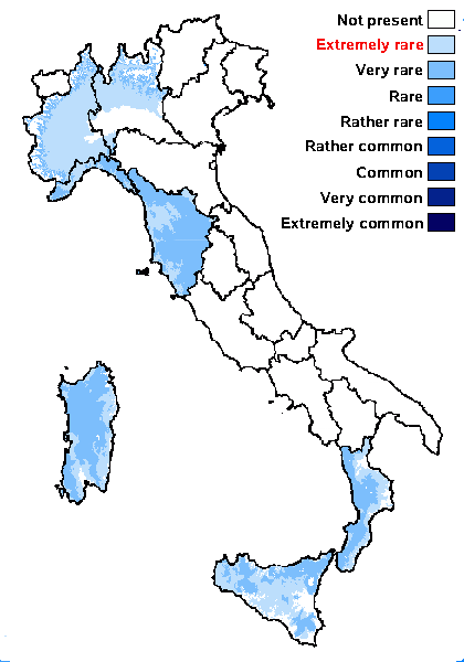
Distribution: N - Lomb, Piem (Isocrono & al. 2004), Lig. C - Tosc, Sar (Nöske 2000). S - Cal (Puntillo 1996), Si.
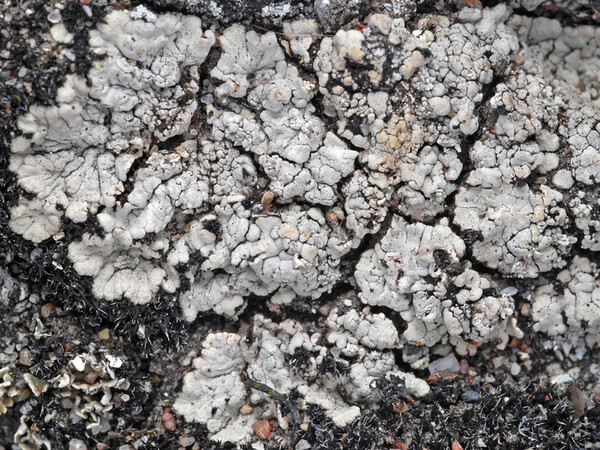
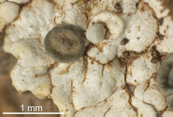
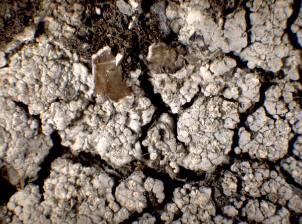
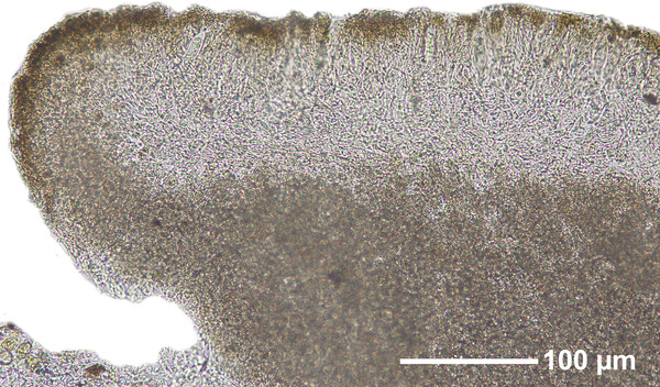
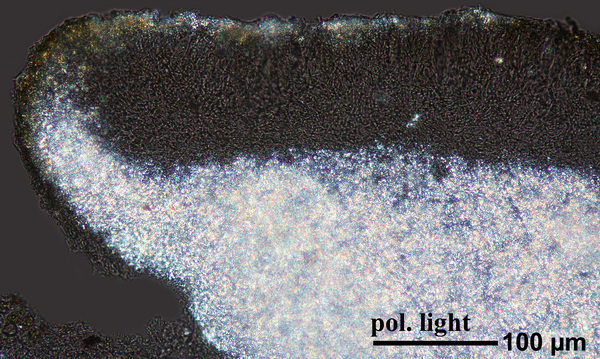
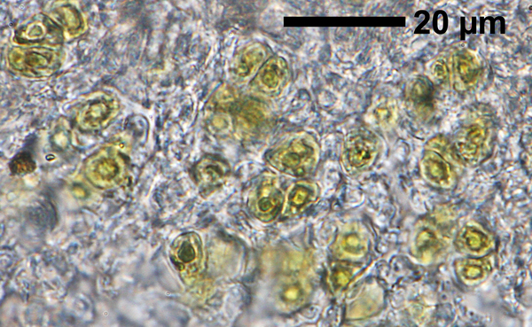
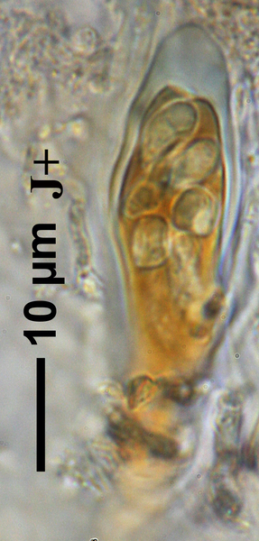
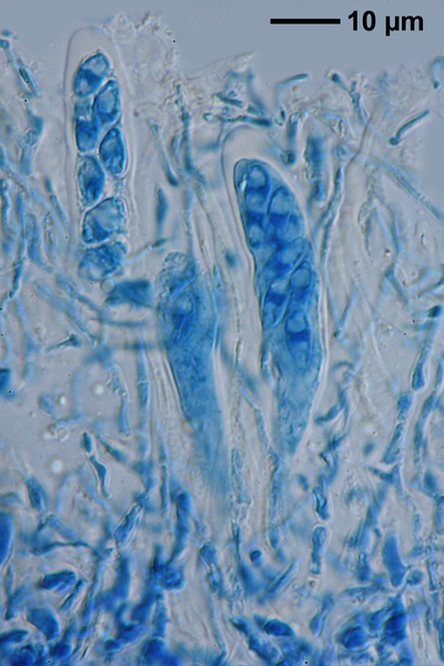
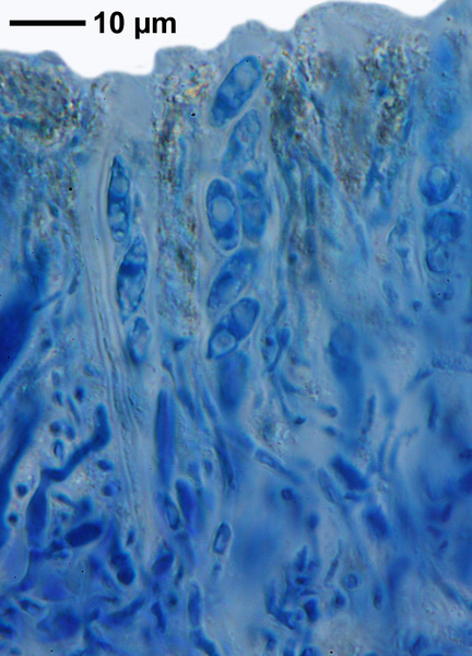
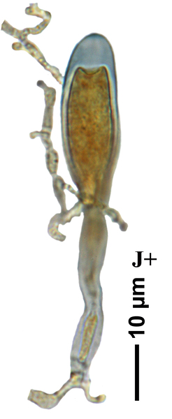
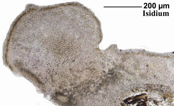
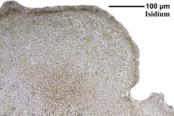
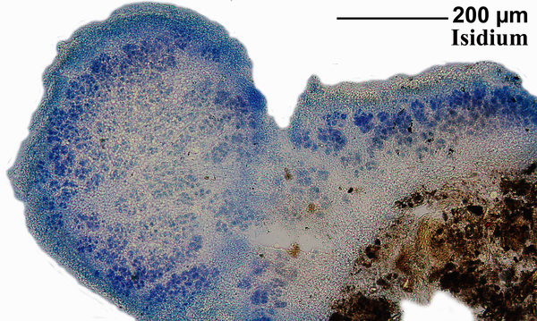
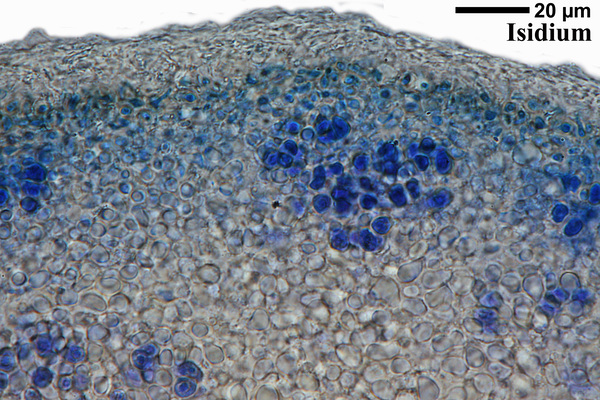
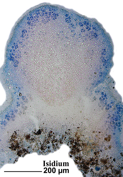
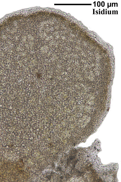
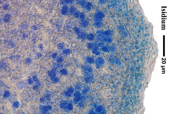
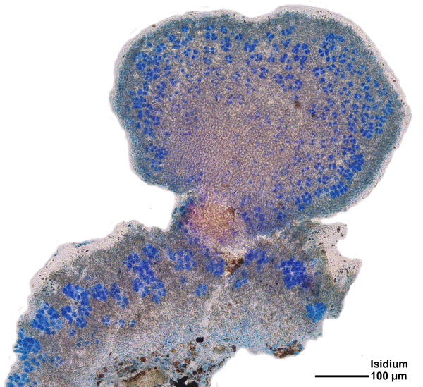
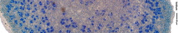
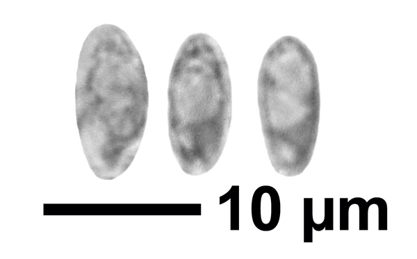
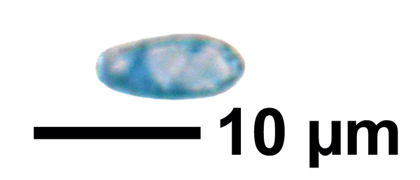
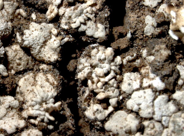
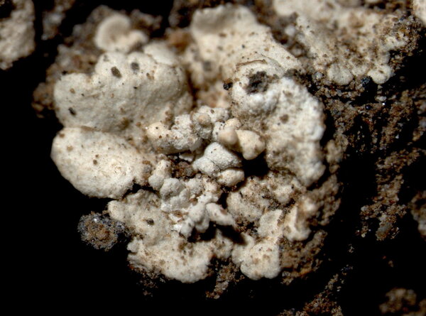
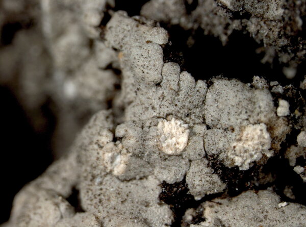
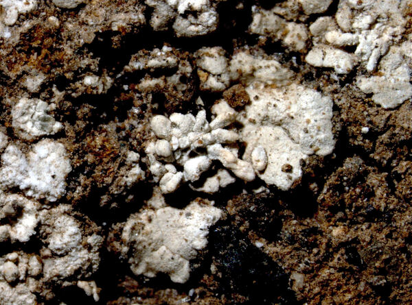
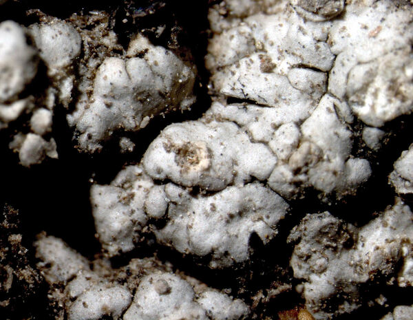
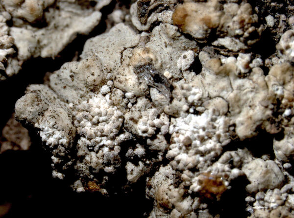
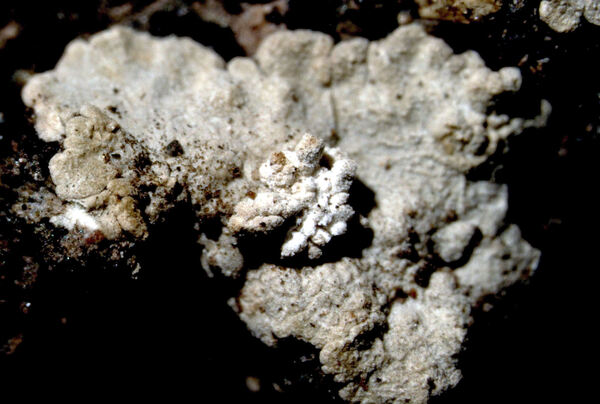
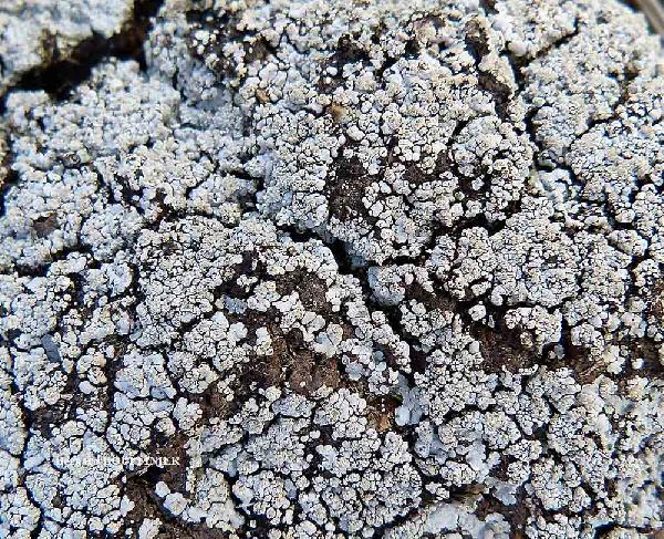
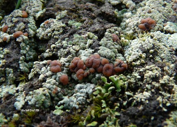
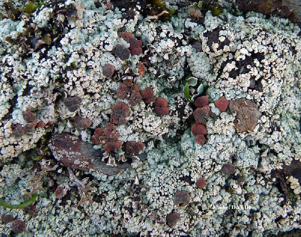
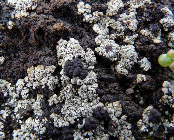
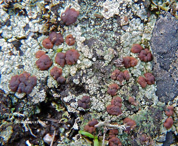
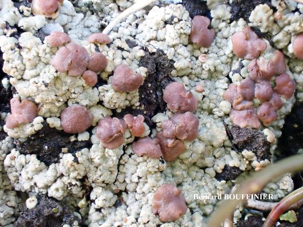
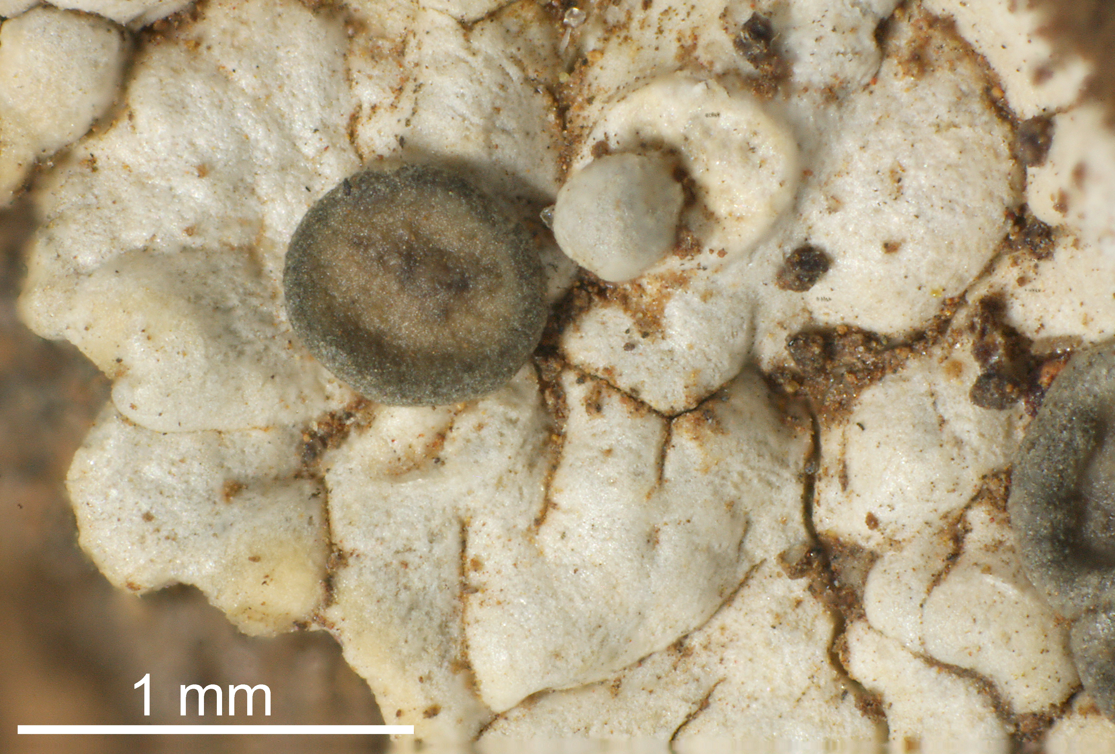
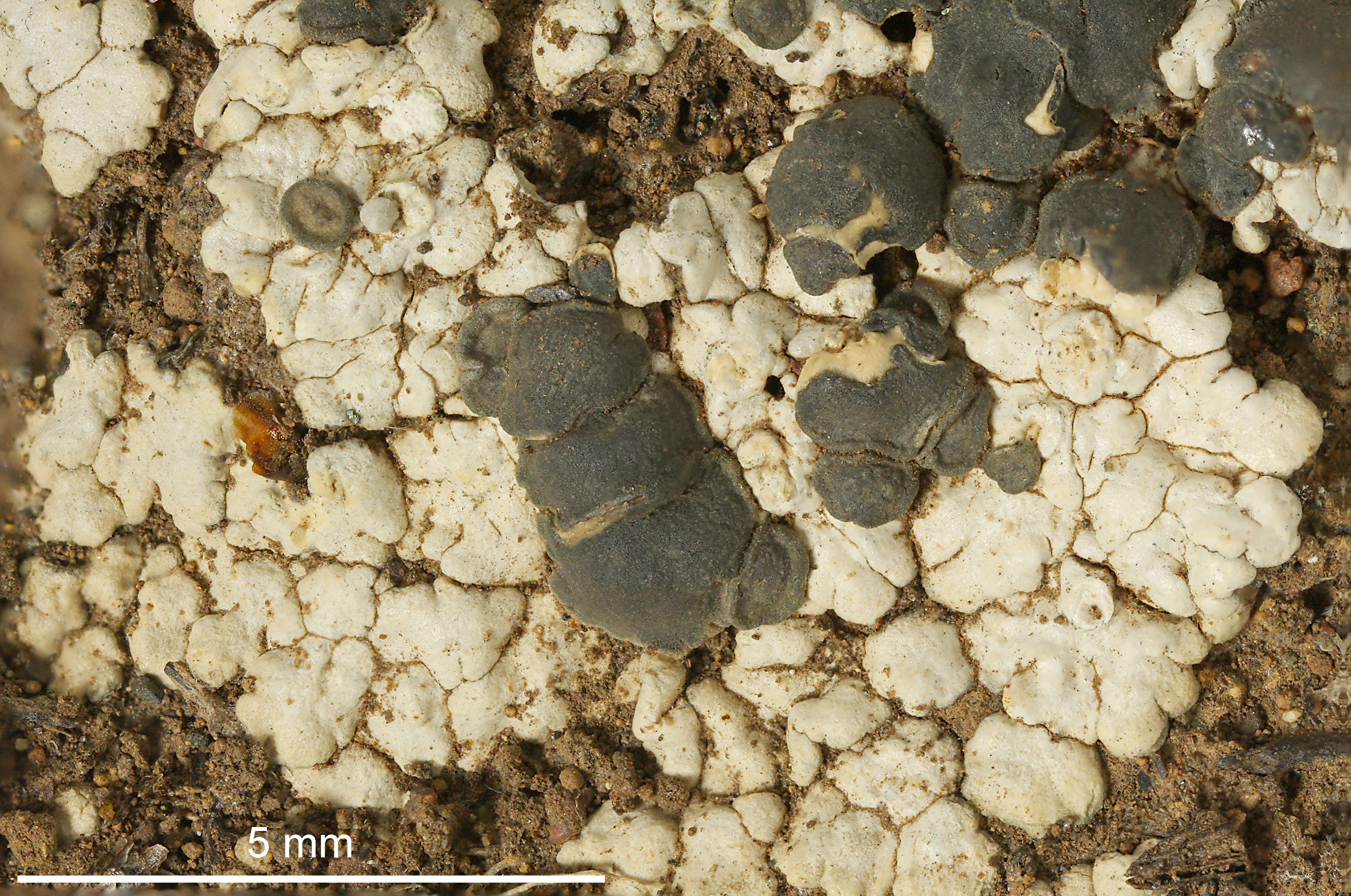
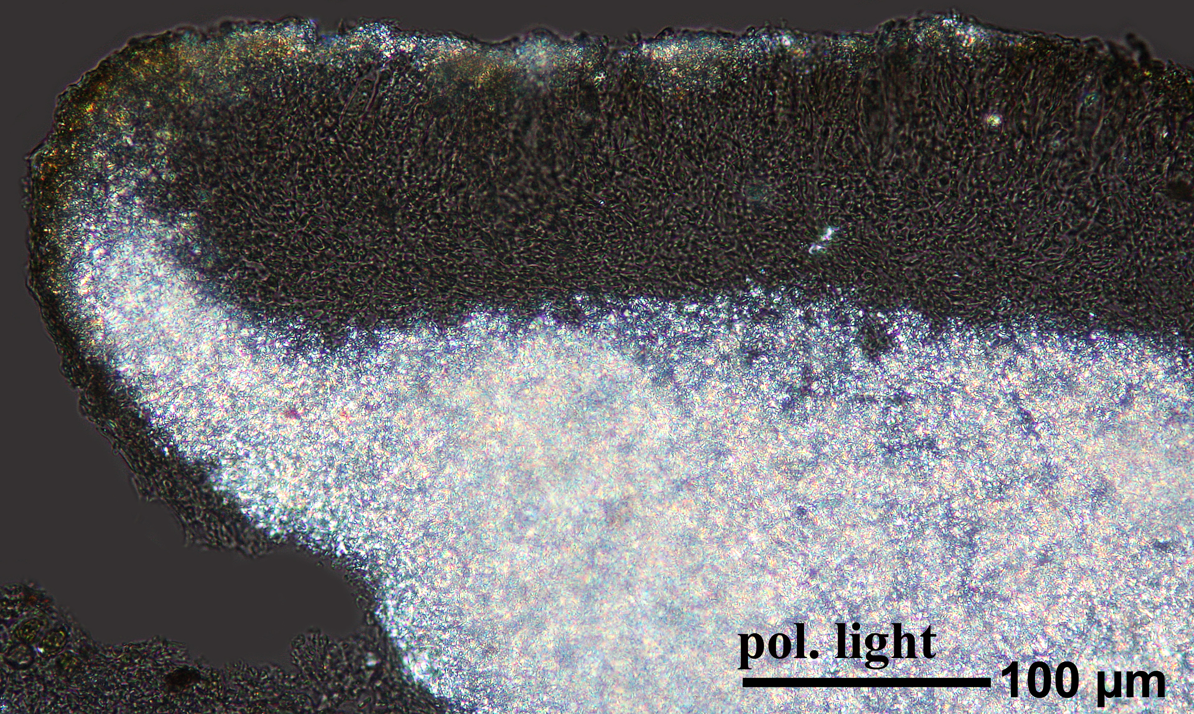
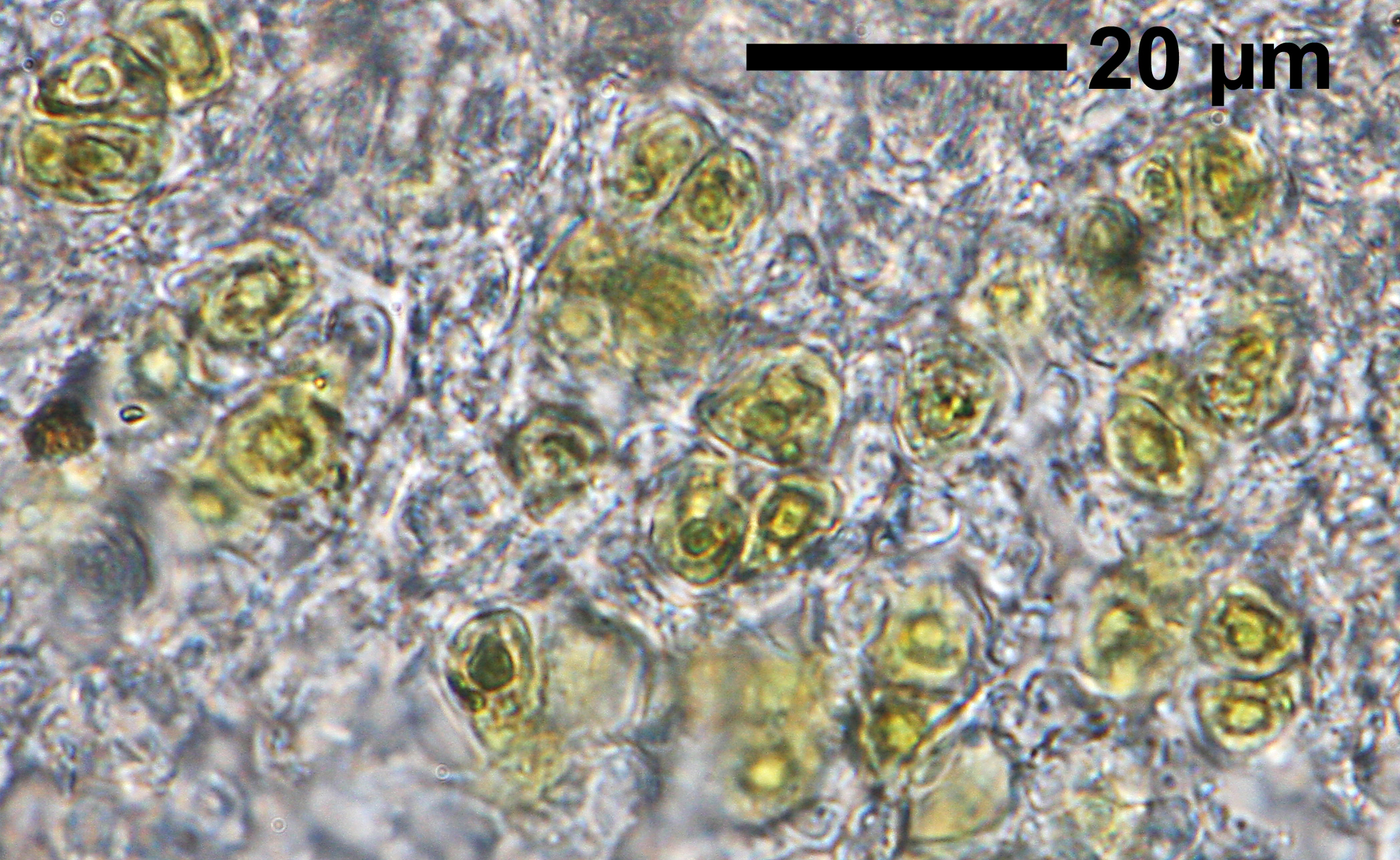
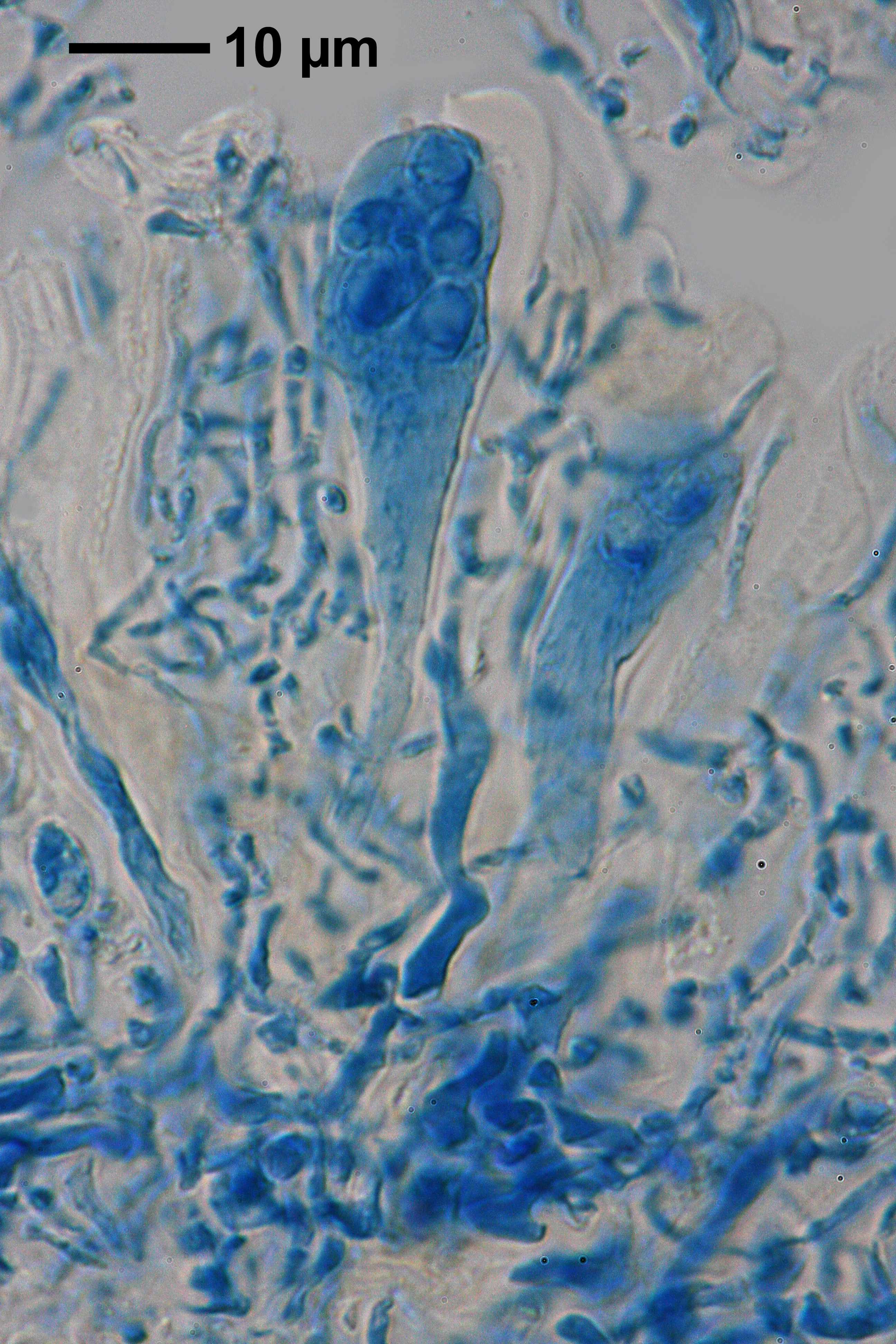
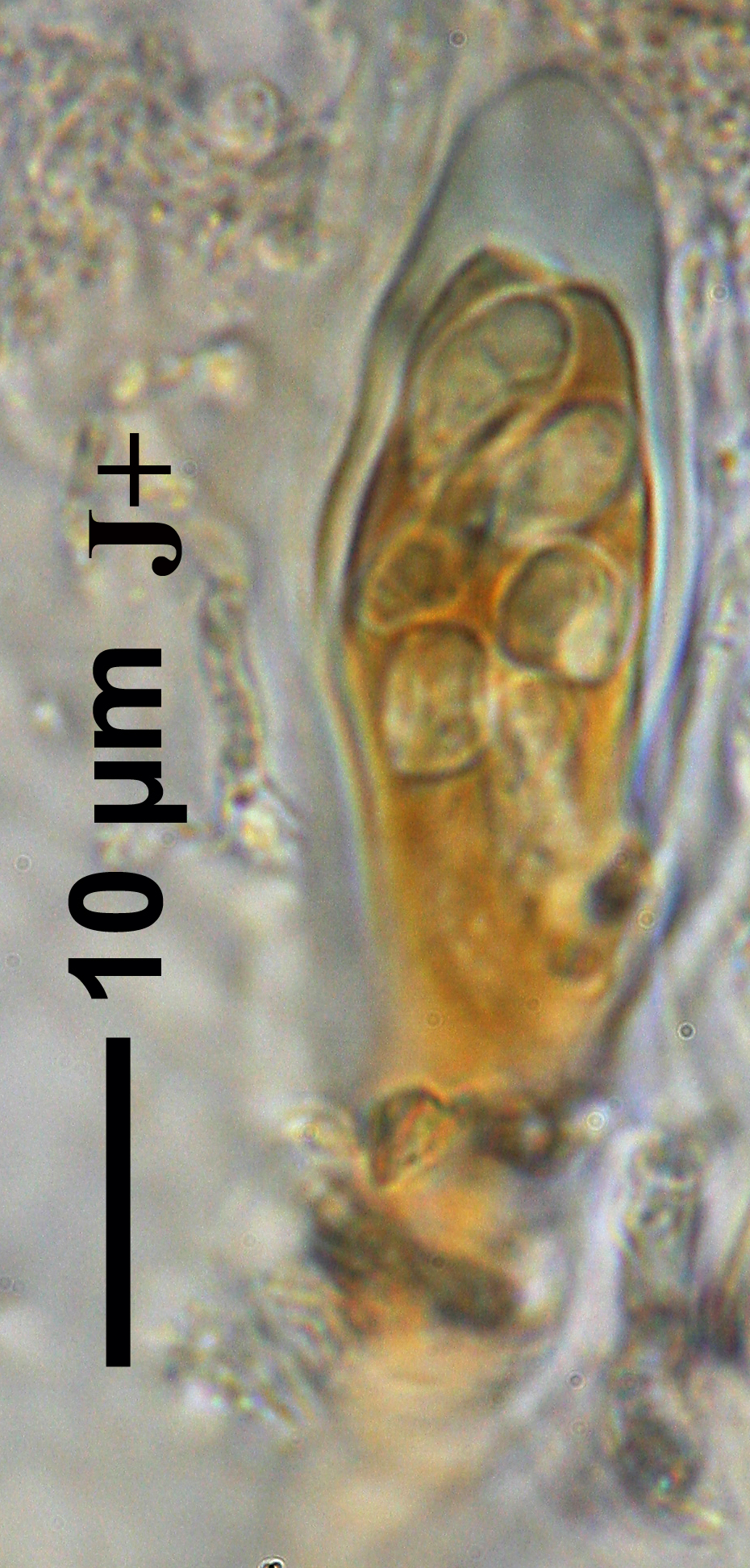
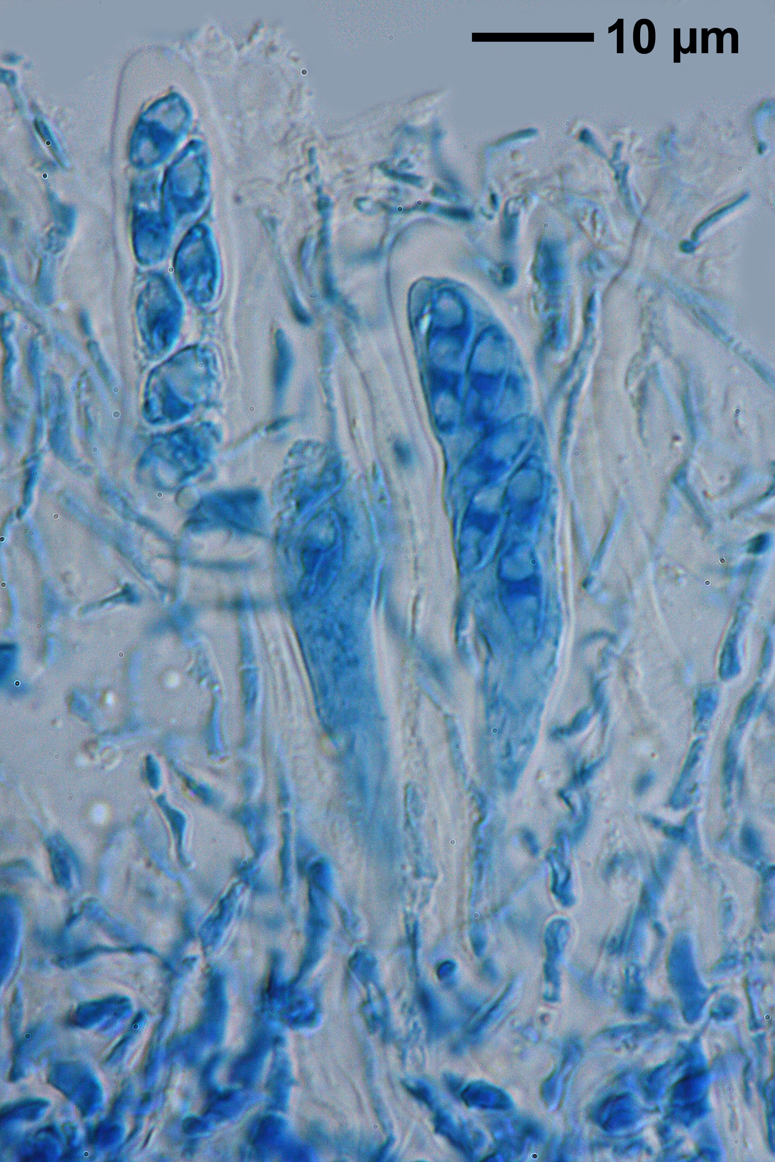
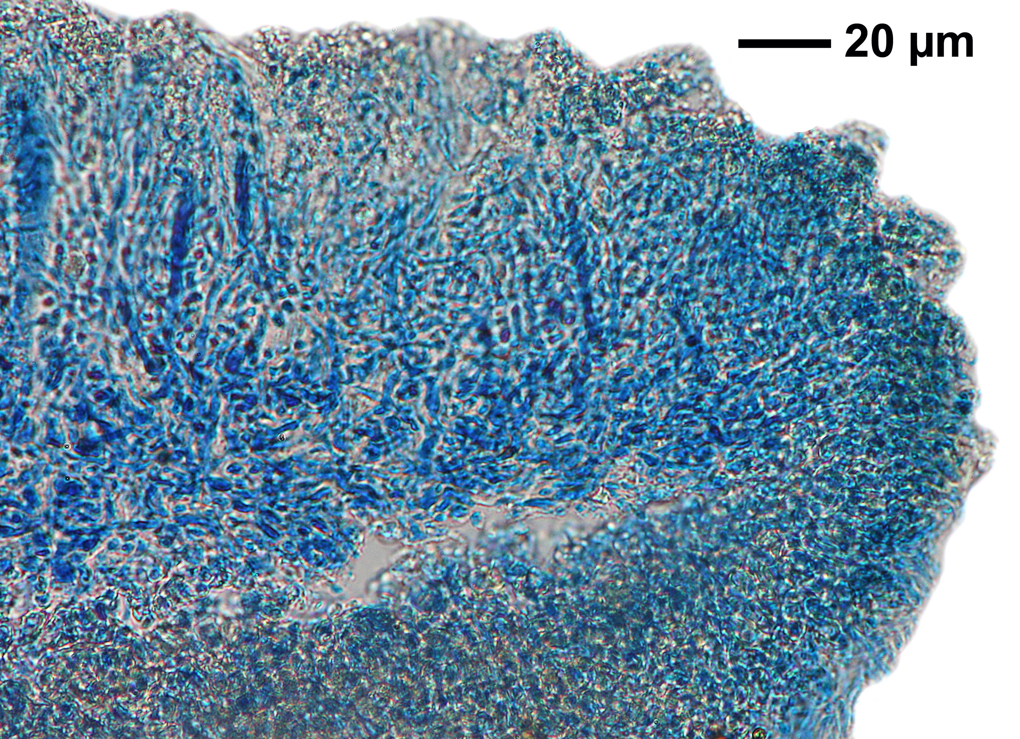
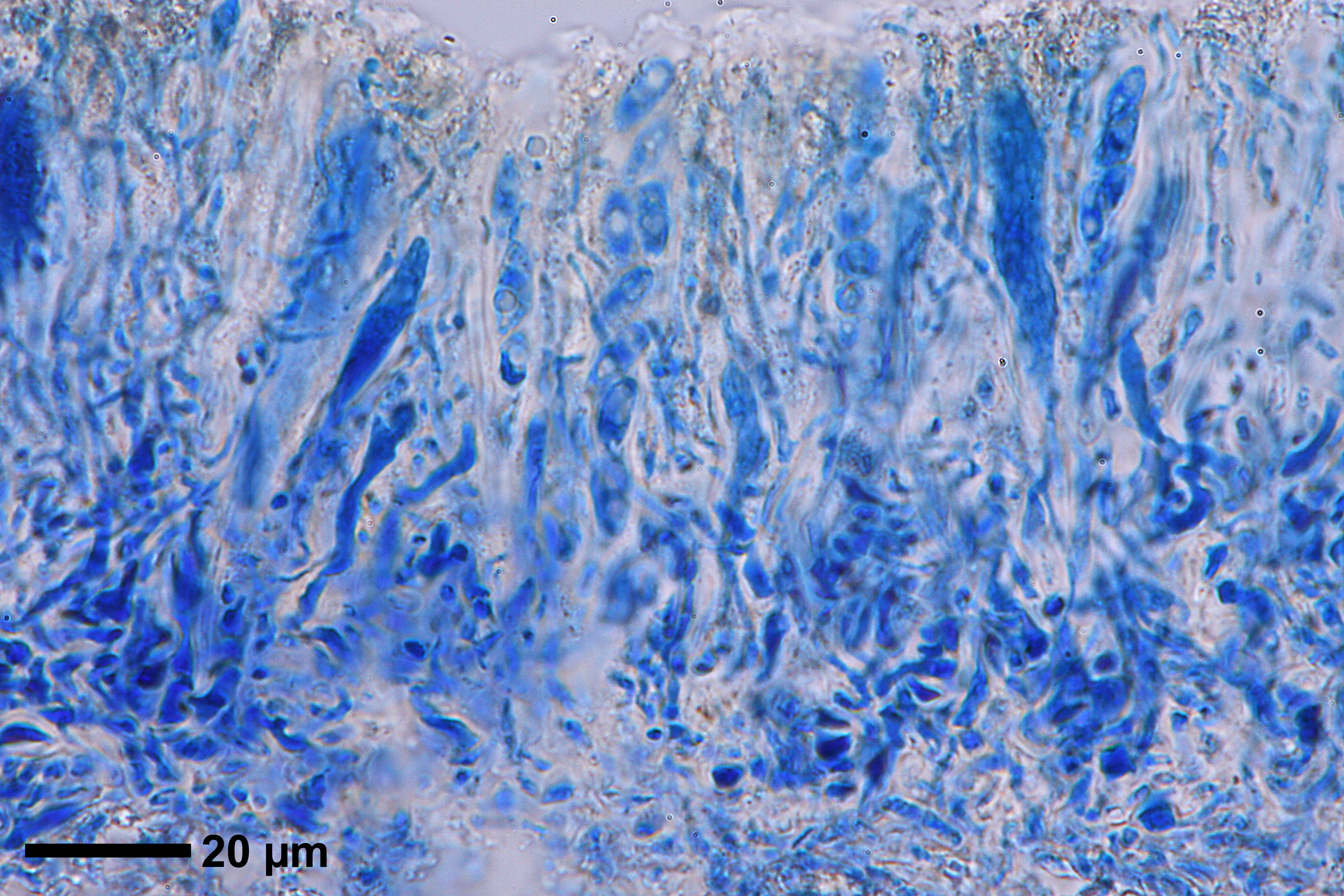
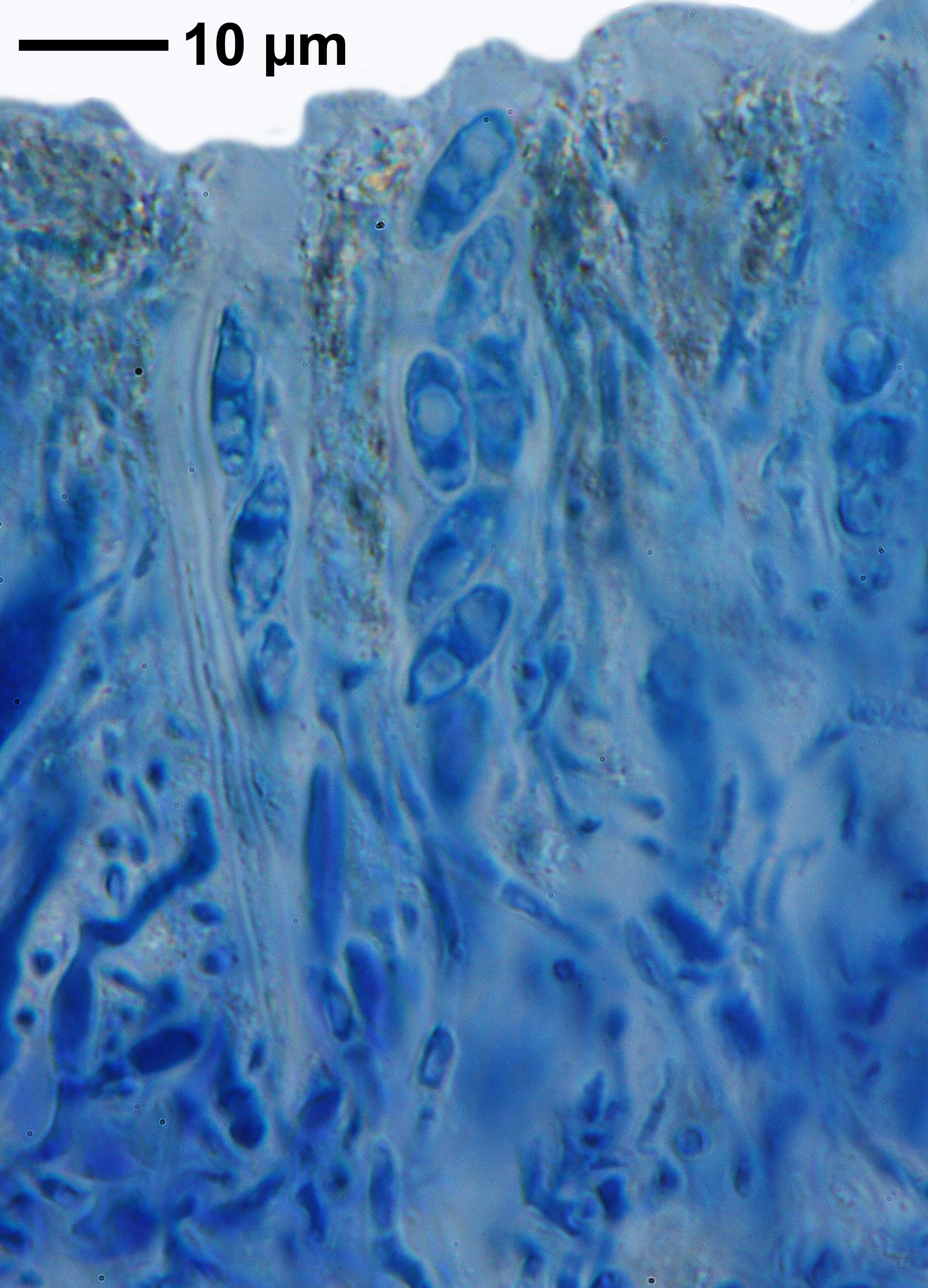
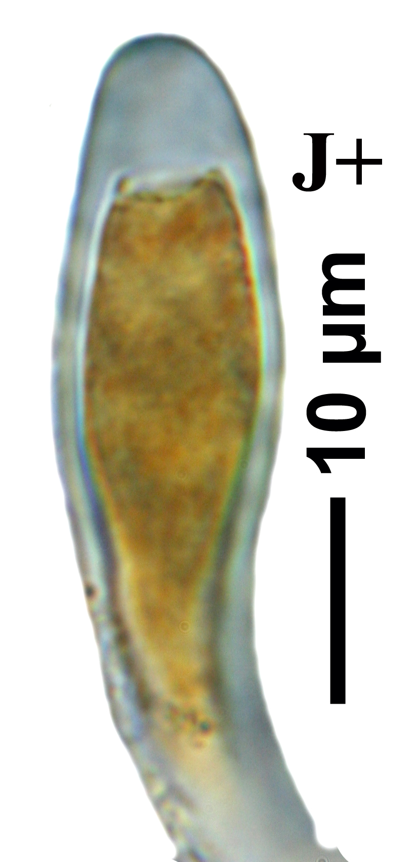
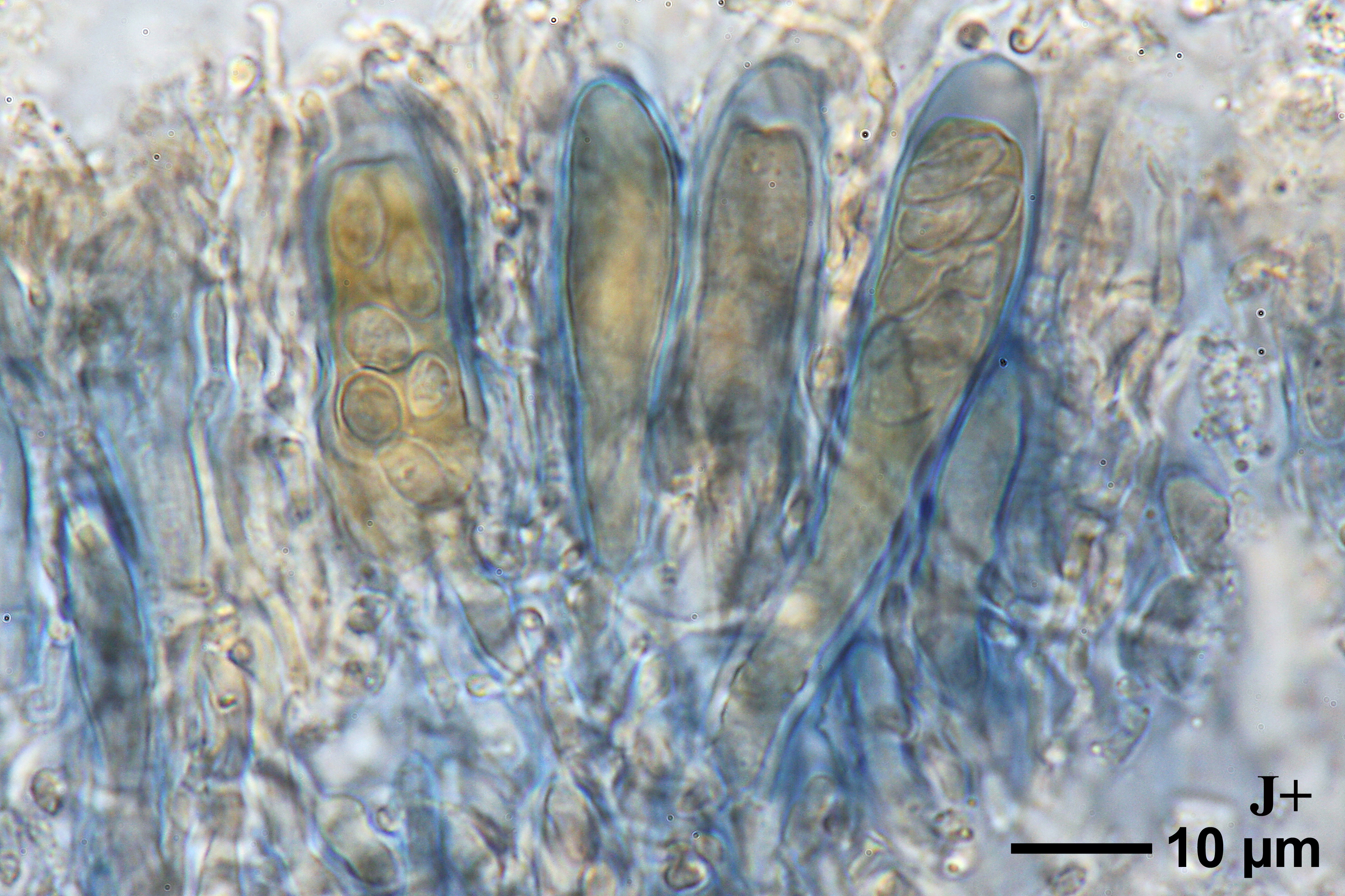
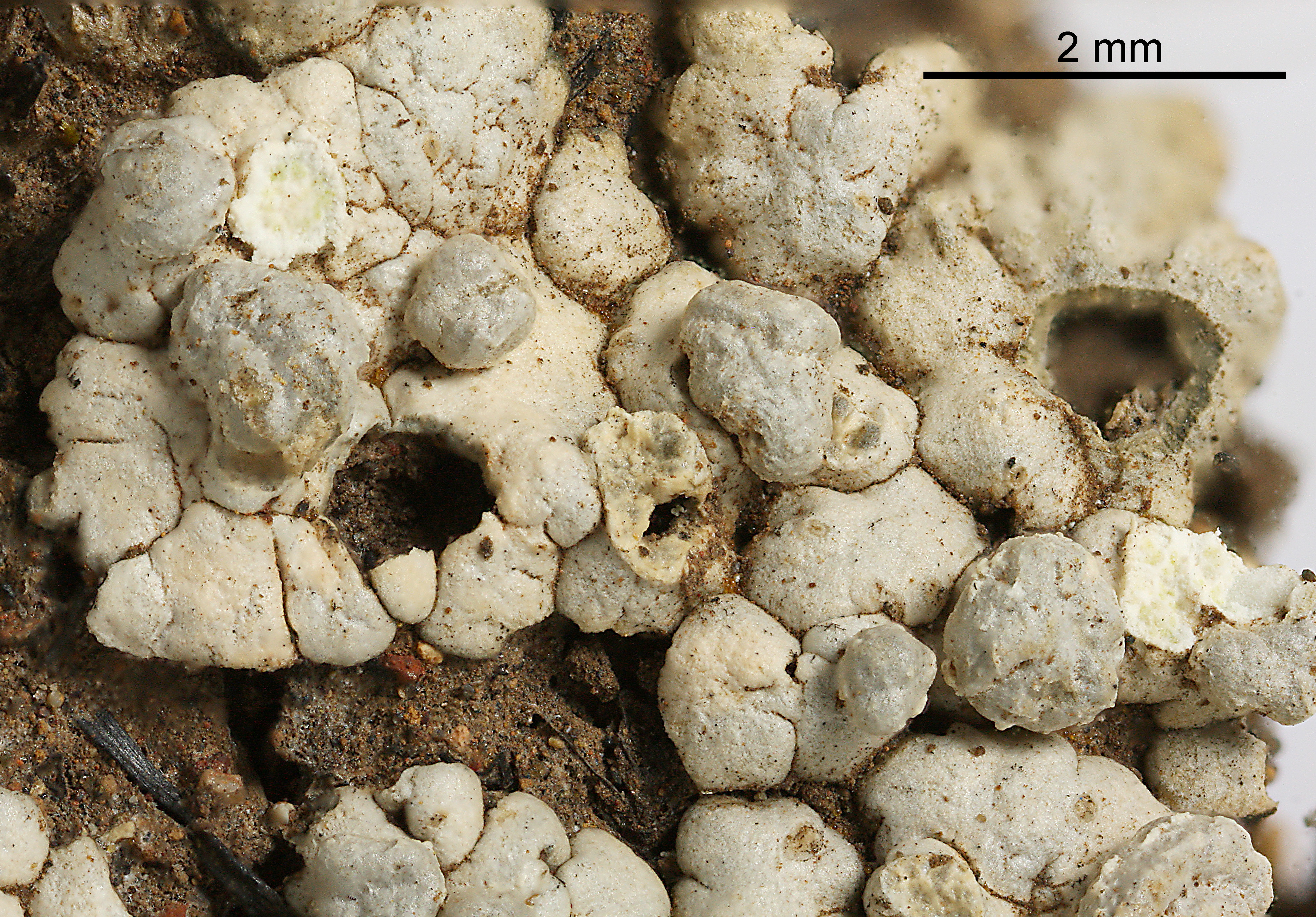
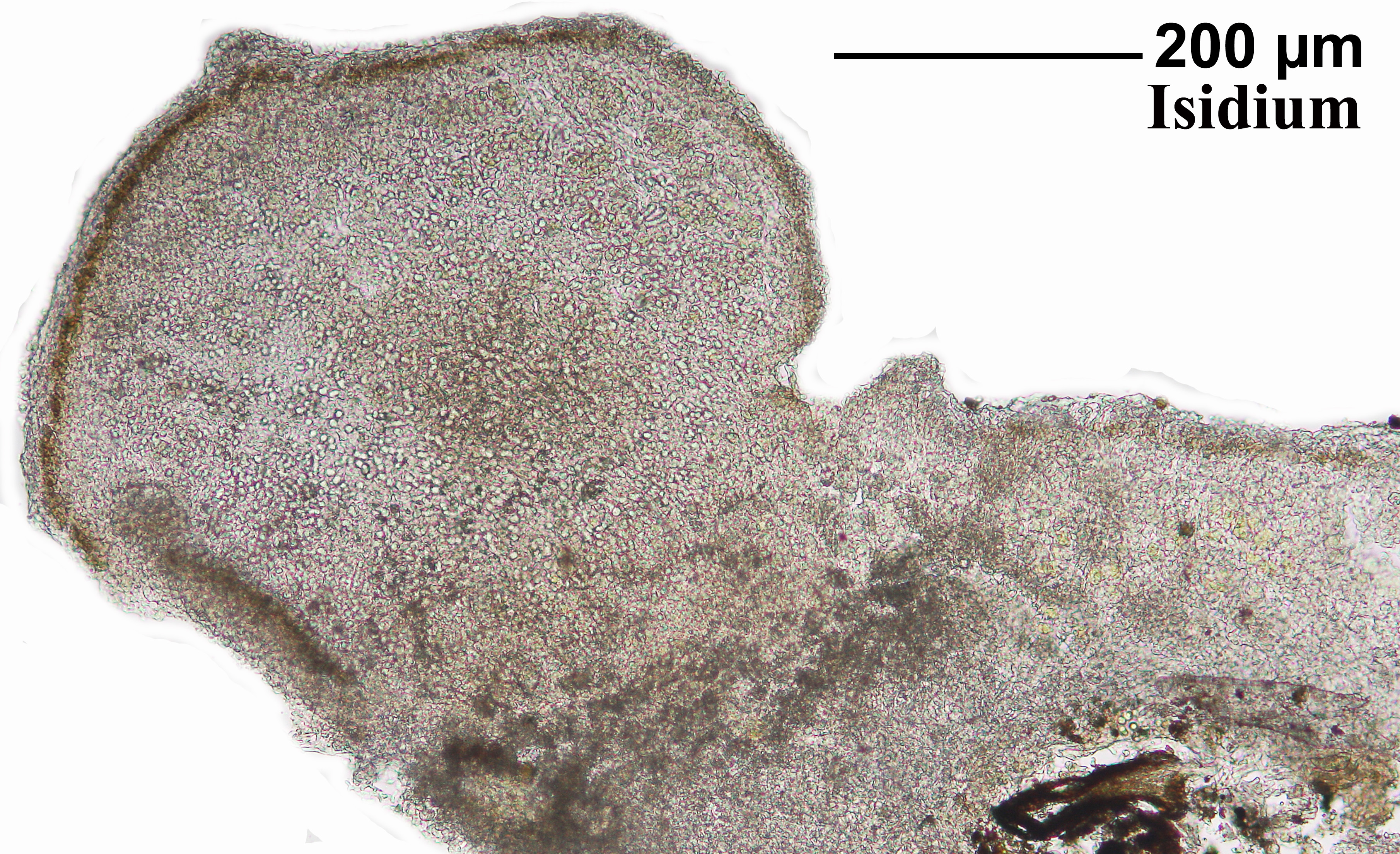
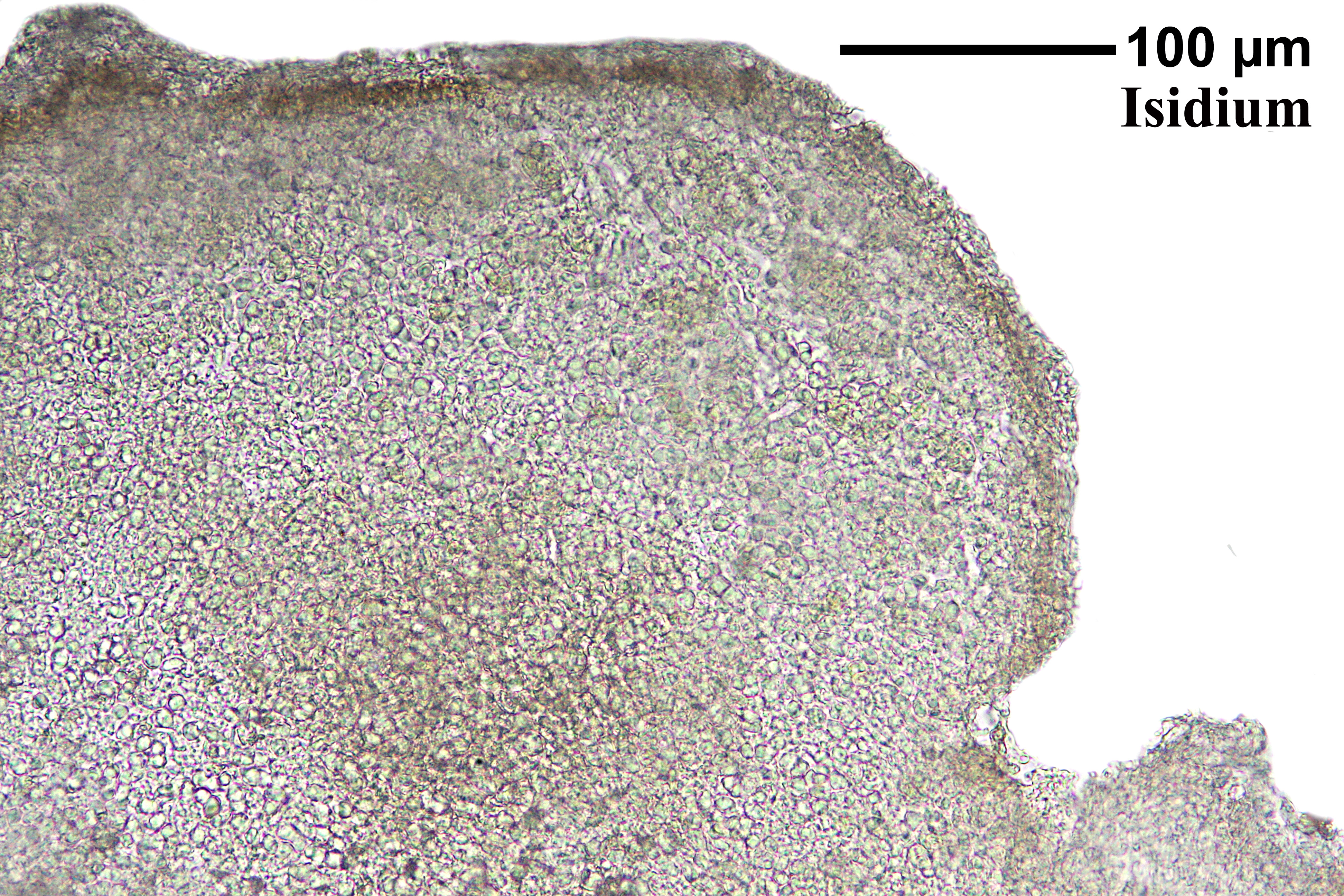
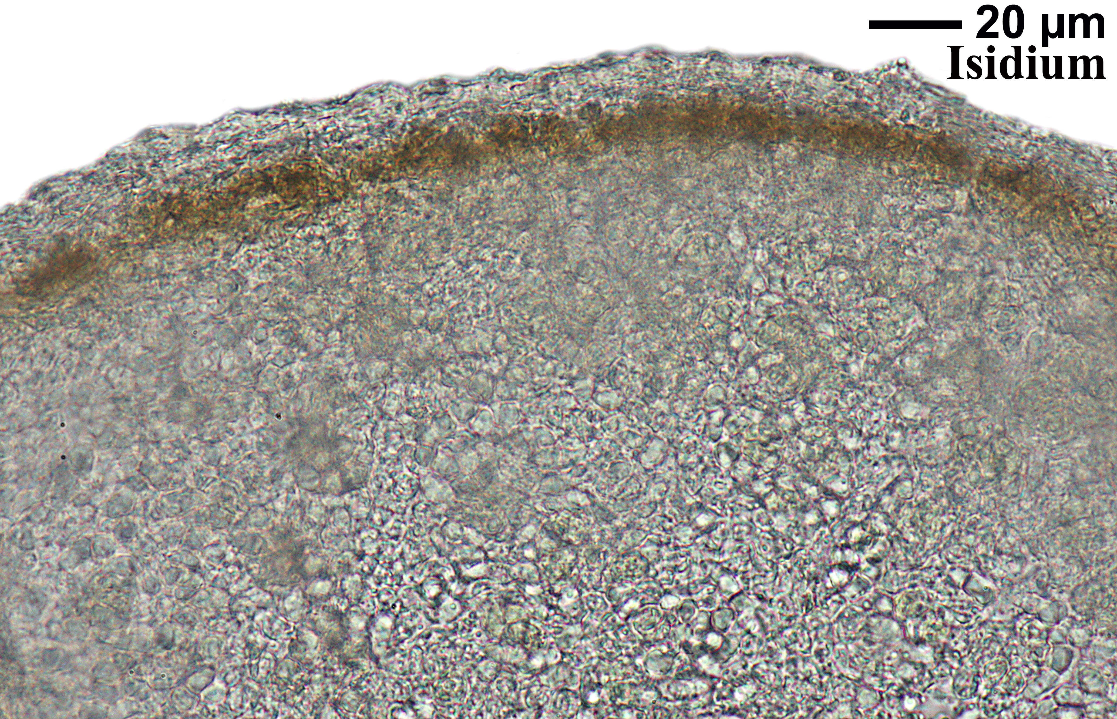
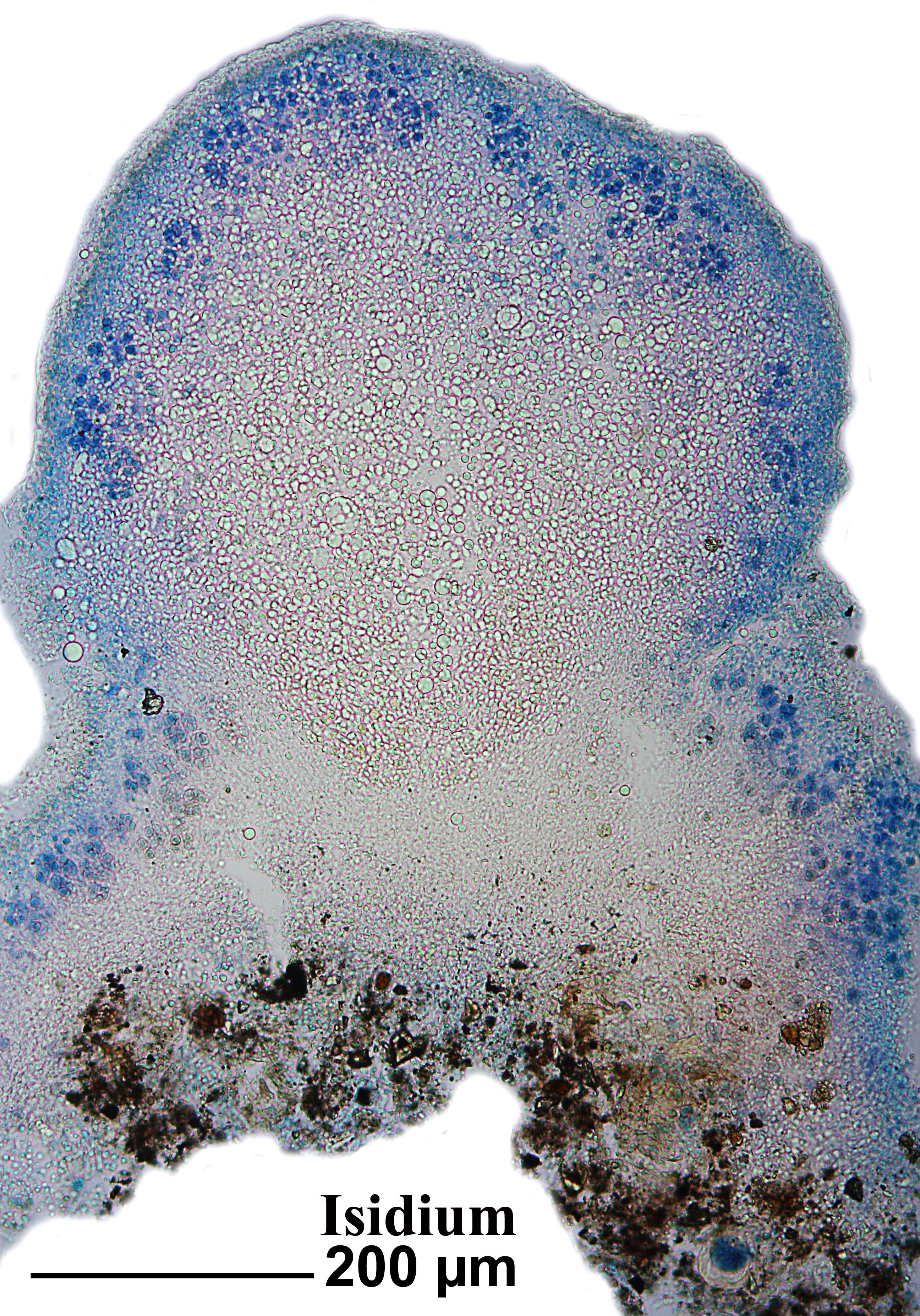
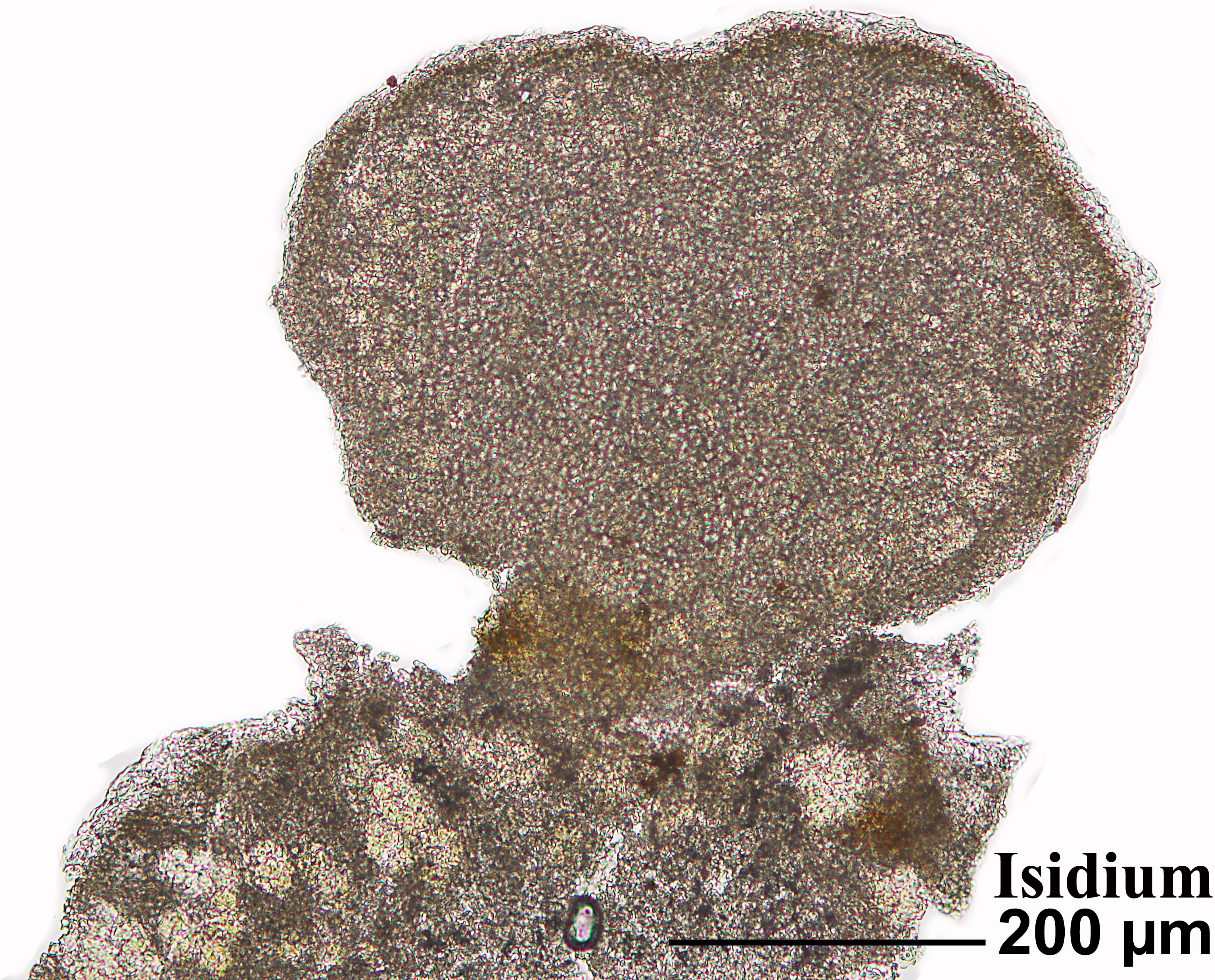
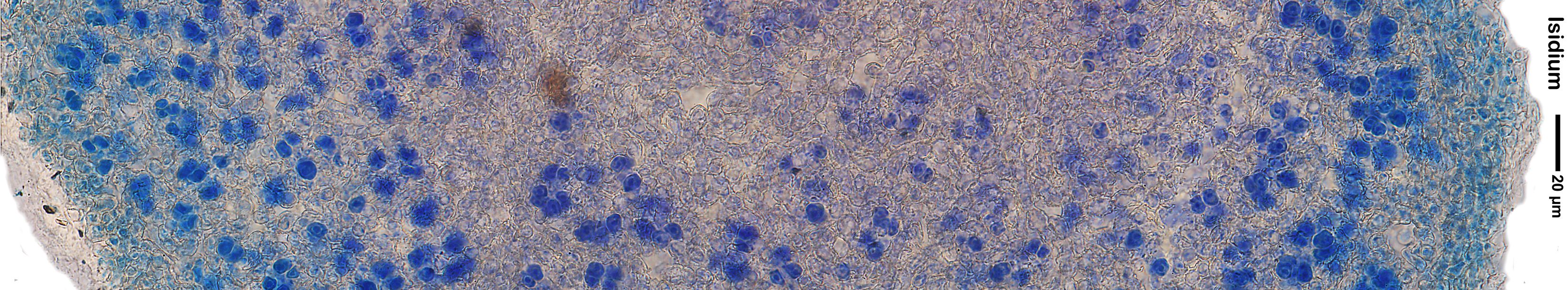
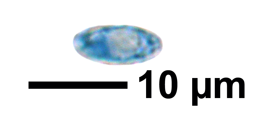
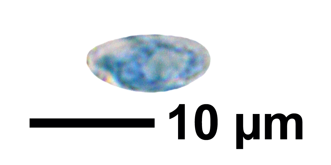
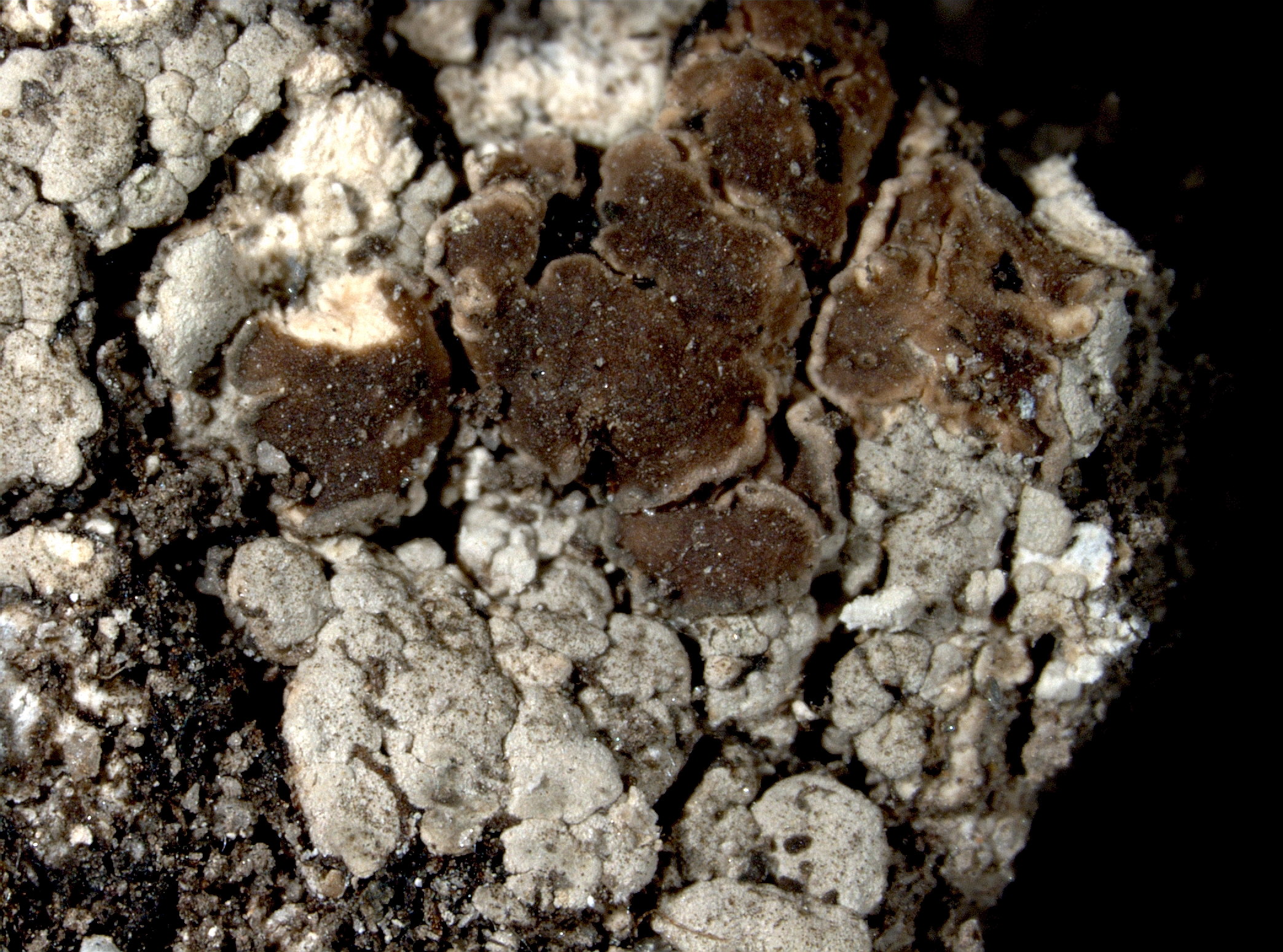
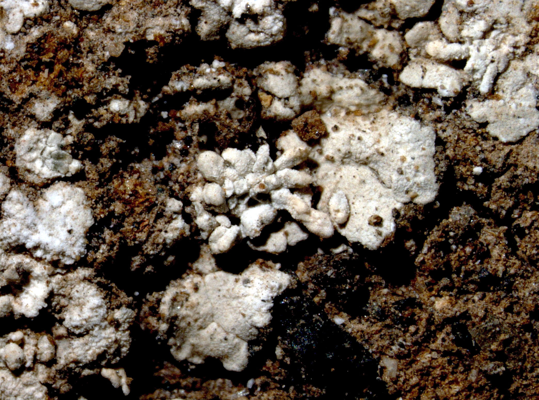
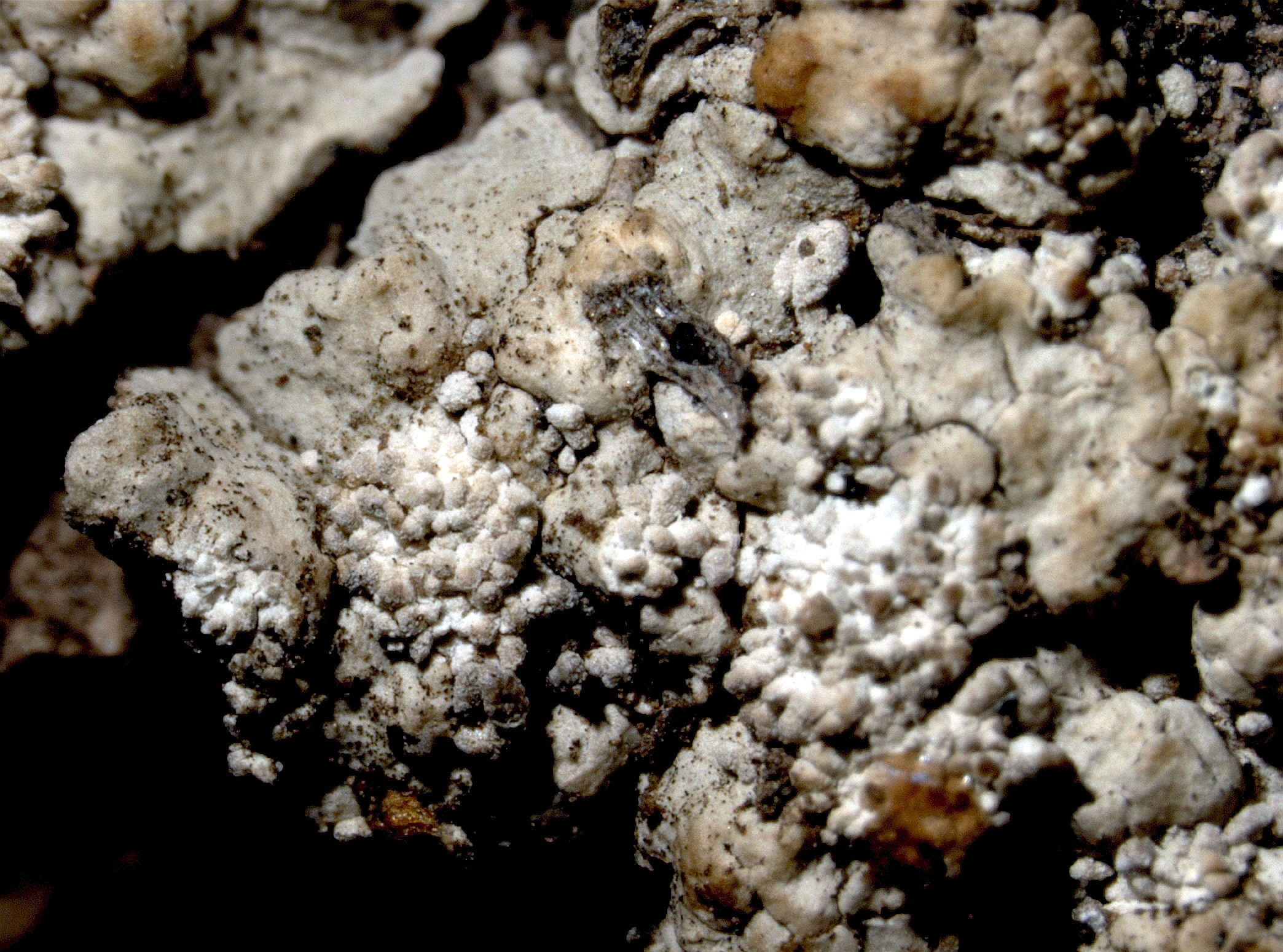
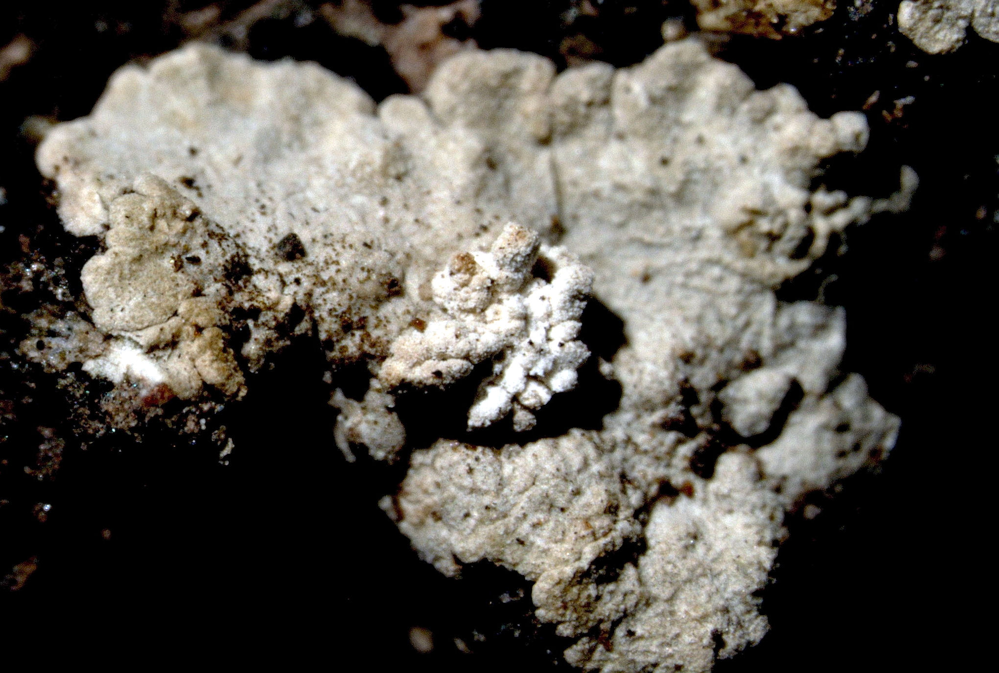
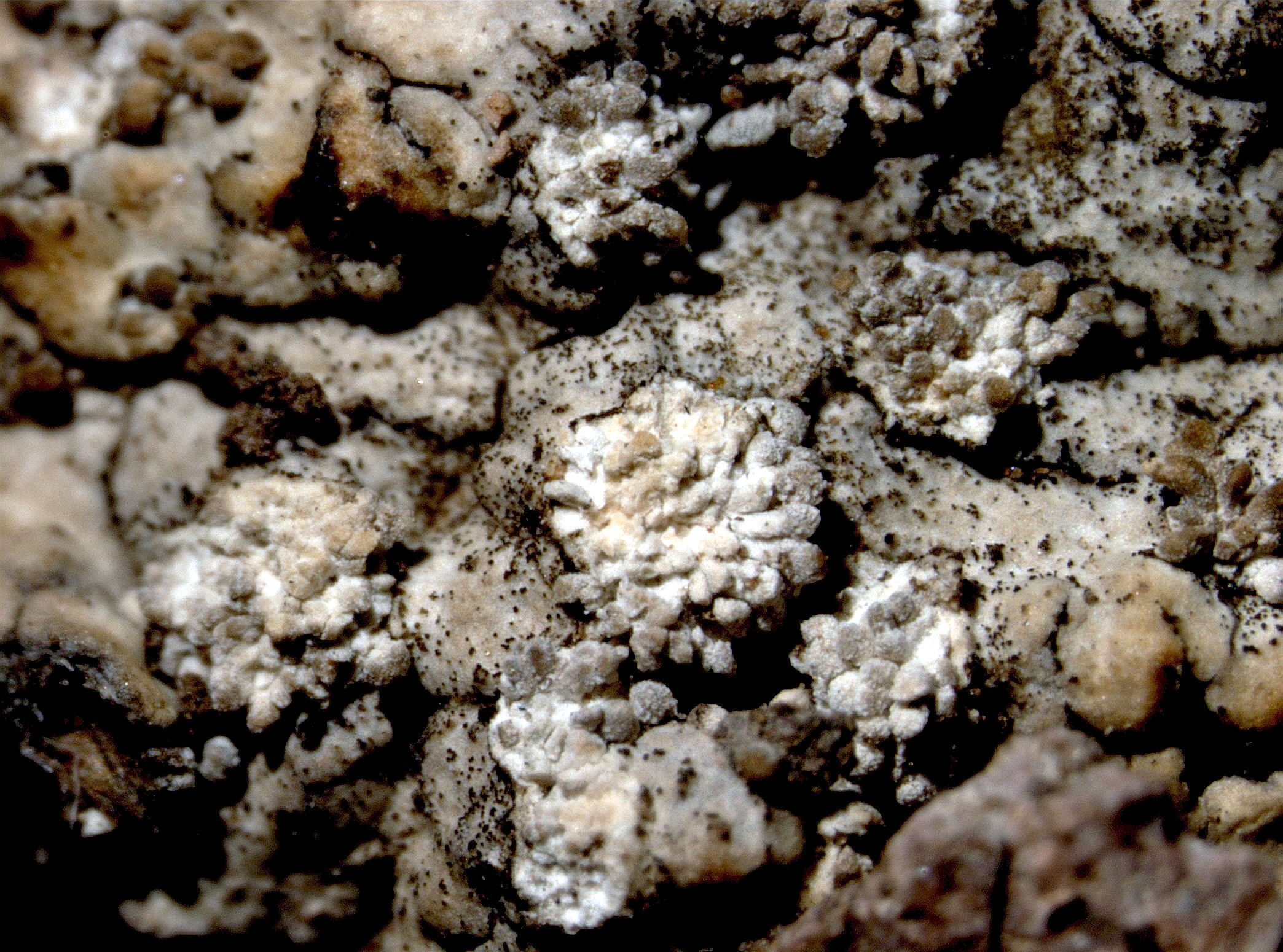
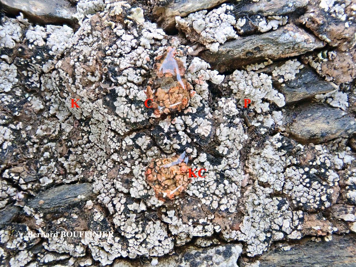
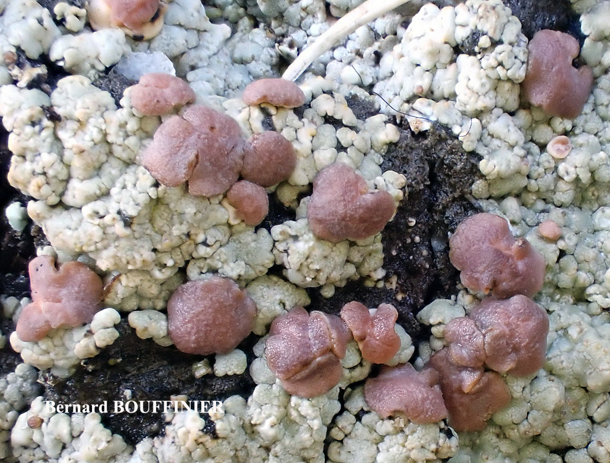
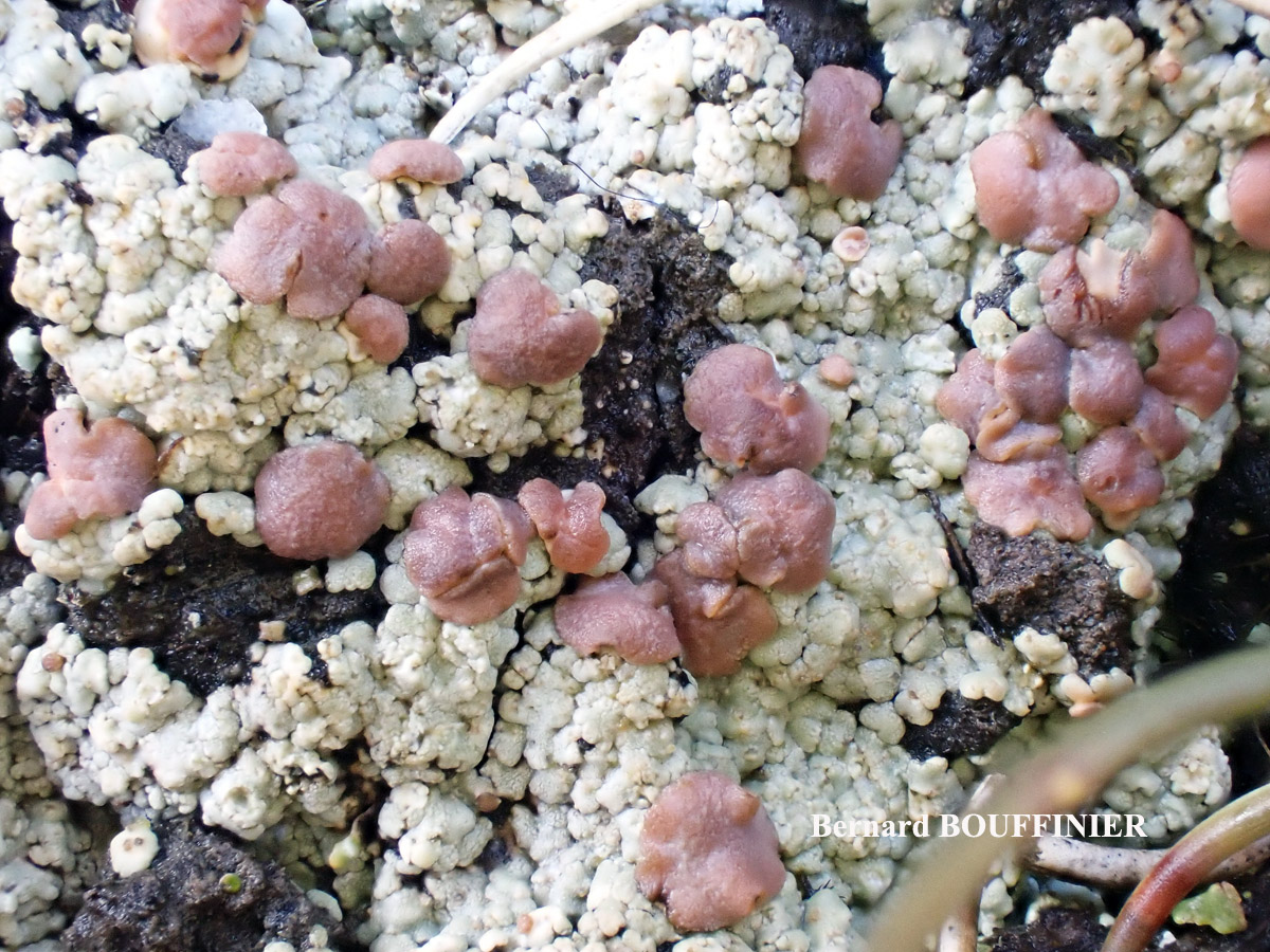
Description: Thallus squamulose to subcrustose-placodioid, whitish to pale grey, rather thick. Squamules rounded to angular, flattened to convex, contiguous, areolate-subcrustose in the centre, elongated at the periphery to form a subrosulate thallus, the marginal lobes 0.5-1 mm wide, to c. 3 mm long. Isidia laminal, simple, coarsely granular to spathulate, clustered in rounded patches which are evident also when the isidia have fallen. Apothecia lecideine, sessile, up to 1.5(-2) mm across, often confluent and to 3.5 mm wide, with a pink-brown to brown-black (paler when wet), sometimes faintly pruinose, flat to strongly convex, sometimes tuberculate disc, and a thin, often paler, finally often excluded proper margin. Proper exciple of densely entangled, colourless hyphae embedded in a colourless to weakly pigmented gel; epithecium golden brown; hymenium colourless; paraphyses coherent, slender, branched and anastomosing, not thickened at apex; hypothecium pale yellowish brown sometimes with brownish, Ascospores 1-celled, hyaline, ellipsoid, 8-14 x 4-5 µm, thick-walled. Photobiont chlorococcoid. Spot tests: thallus K-, C+ red, KC+ red, P-, UV+ whitish. Chemistry: gyrophoric acid.
Note: on base-rich, non- or weakly calciferous soil, sometimes overgrowing mosses, mostly in open situations, with optimum below the montane belt.
Growth form: Crustose
Substrata: soil, terricolous mosses, and plant debris
Photobiont: green algae other than Trentepohlia
Reproductive strategy: mainly asexual, by isidia, or isidia-like structures (e.g. schizidia)
Commonnes-rarity: (info)
Alpine belt: absent
Subalpine belt: absent
Oromediterranean belt: absent
Montane belt: very rare
Submediterranean belt: extremely rare
Padanian area: absent
Humid submediterranean belt: very rare
Humid mediterranean belt: extremely rare
Dry mediterranean belt: absent
Predictive model
Herbarium samples
Leif Stridvall - Source: http://www.stridvall.se/la/galleries.php (Courtesy: Anita Stridvall)

Felix Schumm – CC BY-SA 4.0
[8484], Portugal, Madeira, Paúl da Serra, östlich Rabacal bei Urze, windgefegte Hochfläche, N 32°45.284, W 17°06.474, 1402 m. Leg. Schumm 12.04.2001, det. Aptroot 2011.
P.L. Nimis; Owner: Department of Life Sciences, University of Trieste
Herbarium: TSB (9909)
2001/12/01
Felix Schumm – CC BY-SA 4.0
[8484], Portugal, Madeira, Paúl da Serra, östlich Rabacal bei Urze, windgefegte Hochfläche, N 32°45.284, W 17°06.474, 1402 m. Leg. Schumm 12.04.2001, det. Aptroot 2011.

Felix Schumm – CC BY-SA 4.0
[8484], Portugal, Madeira, Paúl da Serra, östlich Rabacal bei Urze, windgefegte Hochfläche, N 32°45.284, W 17°06.474, 1402 m. Leg. Schumm 12.04.2001, det. Aptroot 2011.
Felix Schumm – CC BY-SA 4.0
[8484], Portugal, Madeira, Paúl da Serra, östlich Rabacal bei Urze, windgefegte Hochfläche, N 32°45.284, W 17°06.474, 1402 m. Leg. Schumm 12.04.2001, det. Aptroot 2011.
Felix Schumm – CC BY-SA 4.0
[8484], Portugal, Madeira, Paúl da Serra, östlich Rabacal bei Urze, windgefegte Hochfläche, N 32°45.284, W 17°06.474, 1402 m. Leg. Schumm 12.04.2001, det. Aptroot 2011.

Felix Schumm – CC BY-SA 4.0
[8484], Portugal, Madeira, Paúl da Serra, östlich Rabacal bei Urze, windgefegte Hochfläche, N 32°45.284, W 17°06.474, 1402 m. Leg. Schumm 12.04.2001, det. Aptroot 2011.
Felix Schumm – CC BY-SA 4.0
[8484], Portugal, Madeira, Paúl da Serra, östlich Rabacal bei Urze, windgefegte Hochfläche, N 32°45.284, W 17°06.474, 1402 m. Leg. Schumm 12.04.2001, det. Aptroot 2011.
Felix Schumm – CC BY-SA 4.0
[8484], Portugal, Madeira, Paúl da Serra, östlich Rabacal bei Urze, windgefegte Hochfläche, N 32°45.284, W 17°06.474, 1402 m. Leg. Schumm 12.04.2001, det. Aptroot 2011.

Felix Schumm – CC BY-SA 4.0
[8484], Portugal, Madeira, Paúl da Serra, östlich Rabacal bei Urze, windgefegte Hochfläche, N 32°45.284, W 17°06.474, 1402 m. Leg. Schumm 12.04.2001, det. Aptroot 2011.

Felix Schumm – CC BY-SA 4.0
[8484], Portugal, Madeira, Paúl da Serra, östlich Rabacal bei Urze, windgefegte Hochfläche, N 32°45.284, W 17°06.474, 1402 m. Leg. Schumm 12.04.2001, det. Aptroot 2011.
Felix Schumm – CC BY-SA 4.0
[8484], Portugal, Madeira, Paúl da Serra, östlich Rabacal bei Urze, windgefegte Hochfläche, N 32°45.284, W 17°06.474, 1402 m. Leg. Schumm 12.04.2001, det. Aptroot 2011.
Felix Schumm – CC BY-SA 4.0
[8484], Portugal, Madeira, Paúl da Serra, östlich Rabacal bei Urze, windgefegte Hochfläche, N 32°45.284, W 17°06.474, 1402 m. Leg. Schumm 12.04.2001, det. Aptroot 2011.

Felix Schumm – CC BY-SA 4.0
[8484], Portugal, Madeira, Paúl da Serra, östlich Rabacal bei Urze, windgefegte Hochfläche, N 32°45.284, W 17°06.474, 1402 m. Leg. Schumm 12.04.2001, det. Aptroot 2011.

Felix Schumm – CC BY-SA 4.0
[8484], Portugal, Madeira, Paúl da Serra, östlich Rabacal bei Urze, windgefegte Hochfläche, N 32°45.284, W 17°06.474, 1402 m. Leg. Schumm 12.04.2001, det. Aptroot 2011.

Felix Schumm – CC BY-SA 4.0
[8484], Portugal, Madeira, Paúl da Serra, östlich Rabacal bei Urze, windgefegte Hochfläche, N 32°45.284, W 17°06.474, 1402 m. Leg. Schumm 12.04.2001, det. Aptroot 2011.
Felix Schumm – CC BY-SA 4.0
[8484], Portugal, Madeira, Paúl da Serra, östlich Rabacal bei Urze, windgefegte Hochfläche, N 32°45.284, W 17°06.474, 1402 m. Leg. Schumm 12.04.2001, det. Aptroot 2011.
Felix Schumm – CC BY-SA 4.0
[8484], Portugal, Madeira, Paúl da Serra, östlich Rabacal bei Urze, windgefegte Hochfläche, N 32°45.284, W 17°06.474, 1402 m. Leg. Schumm 12.04.2001, det. Aptroot 2011.

Felix Schumm – CC BY-SA 4.0
[8484], Portugal, Madeira, Paúl da Serra, östlich Rabacal bei Urze, windgefegte Hochfläche, N 32°45.284, W 17°06.474, 1402 m. Leg. Schumm 12.04.2001, det. Aptroot 2011.
Felix Schumm – CC BY-SA 4.0
[8484], Portugal, Madeira, Paúl da Serra, östlich Rabacal bei Urze, windgefegte Hochfläche, N 32°45.284, W 17°06.474, 1402 m. Leg. Schumm 12.04.2001, det. Aptroot 2011.
Felix Schumm – CC BY-SA 4.0
[8484], Portugal, Madeira, Paúl da Serra, östlich Rabacal bei Urze, windgefegte Hochfläche, N 32°45.284, W 17°06.474, 1402 m. Leg. Schumm 12.04.2001, det. Aptroot 2011.
Felix Schumm – CC BY-SA 4.0
[8484], Portugal, Madeira, Paúl da Serra, östlich Rabacal bei Urze, windgefegte Hochfläche, N 32°45.284, W 17°06.474, 1402 m. Leg. Schumm 12.04.2001, det. Aptroot 2011.

Felix Schumm – CC BY-SA 4.0
[8484], Portugal, Madeira, Paúl da Serra, östlich Rabacal bei Urze, windgefegte Hochfläche, N 32°45.284, W 17°06.474, 1402 m. Leg. Schumm 12.04.2001, det. Aptroot 2011.
Felix Schumm – CC BY-SA 4.0
[8484], Portugal, Madeira, Paúl da Serra, östlich Rabacal bei Urze, windgefegte Hochfläche, N 32°45.284, W 17°06.474, 1402 m. Leg. Schumm 12.04.2001, det. Aptroot 2011.
Felix Schumm – CC BY-SA 4.0
[8484], Portugal, Madeira, Paúl da Serra, östlich Rabacal bei Urze, windgefegte Hochfläche, N 32°45.284, W 17°06.474, 1402 m. Leg. Schumm 12.04.2001, det. Aptroot 2011.

Felix Schumm – CC BY-SA 4.0
[8484], Portugal, Madeira, Paúl da Serra, östlich Rabacal bei Urze, windgefegte Hochfläche, N 32°45.284, W 17°06.474, 1402 m. Leg. Schumm 12.04.2001, det. Aptroot 2011.
Felix Schumm – CC BY-SA 4.0
[8484], Portugal, Madeira, Paúl da Serra, östlich Rabacal bei Urze, windgefegte Hochfläche, N 32°45.284, W 17°06.474, 1402 m. Leg. Schumm 12.04.2001, det. Aptroot 2011.
Felix Schumm – CC BY-SA 4.0
[8484], Portugal, Madeira, Paúl da Serra, östlich Rabacal bei Urze, windgefegte Hochfläche, N 32°45.284, W 17°06.474, 1402 m. Leg. Schumm 12.04.2001, det. Aptroot 2011.
Felix Schumm – CC BY-SA 4.0
[8484], Portugal, Madeira, Paúl da Serra, östlich Rabacal bei Urze, windgefegte Hochfläche, N 32°45.284, W 17°06.474, 1402 m. Leg. Schumm 12.04.2001, det. Aptroot 2011.
Felix Schumm – CC BY-SA 4.0
[8484], Portugal, Madeira, Paúl da Serra, östlich Rabacal bei Urze, windgefegte Hochfläche, N 32°45.284, W 17°06.474, 1402 m. Leg. Schumm 12.04.2001, det. Aptroot 2011.

Felix Schumm – CC BY-SA 4.0
[8484], Portugal, Madeira, Paúl da Serra, östlich Rabacal bei Urze, windgefegte Hochfläche, N 32°45.284, W 17°06.474, 1402 m. Leg. Schumm 12.04.2001, det. Aptroot 2011.

Felix Schumm – CC BY-SA 4.0
[8484], Portugal, Madeira, Paúl da Serra, östlich Rabacal bei Urze, windgefegte Hochfläche, N 32°45.284, W 17°06.474, 1402 m. Leg. Schumm 12.04.2001, det. Aptroot 2011.
Pier Luigi Nimis - CC BY-SA 4.0
TSB 20331
Pier Luigi Nimis - CC BY-SA 4.0
TSB 20331

Pier Luigi Nimis - CC BY-SA 4.0
TSB 13111
Pier Luigi Nimis - CC BY-SA 4.0
TSB 13111
P.L. Nimis CC BY-SA 4.0
TSB 2033
P.L. Nimis CC BY-SA 4.0
TSB 8532
P.L. Nimis CC BY-SA 4.0
TSB 13133
P.L. Nimis CC BY-SA 4.0
TSB 13133

P.L. Nimis CC BY-SA 4.0
TSB 13133

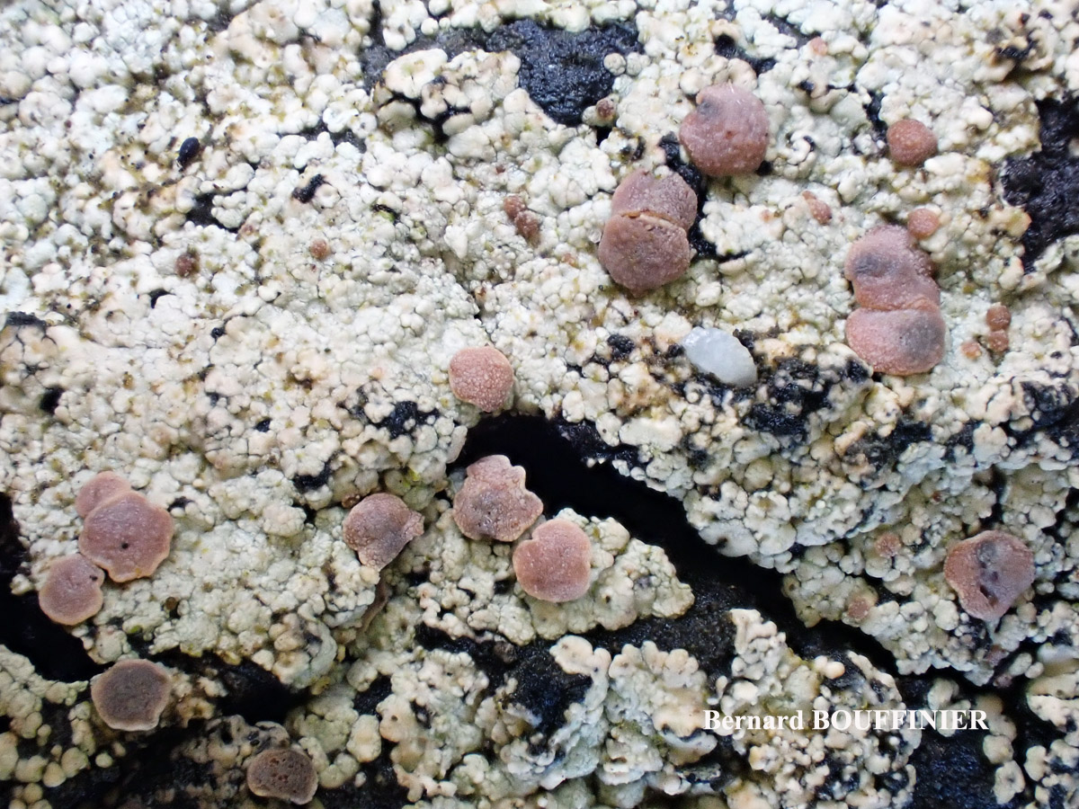
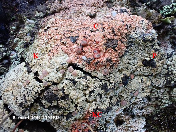
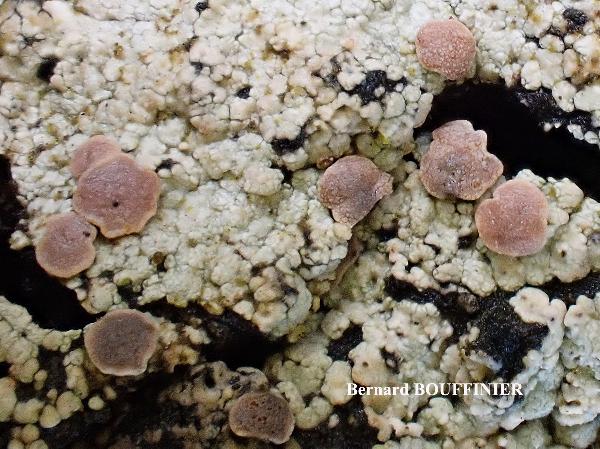
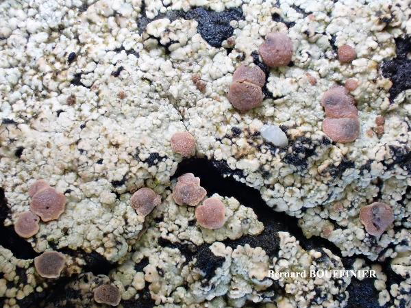
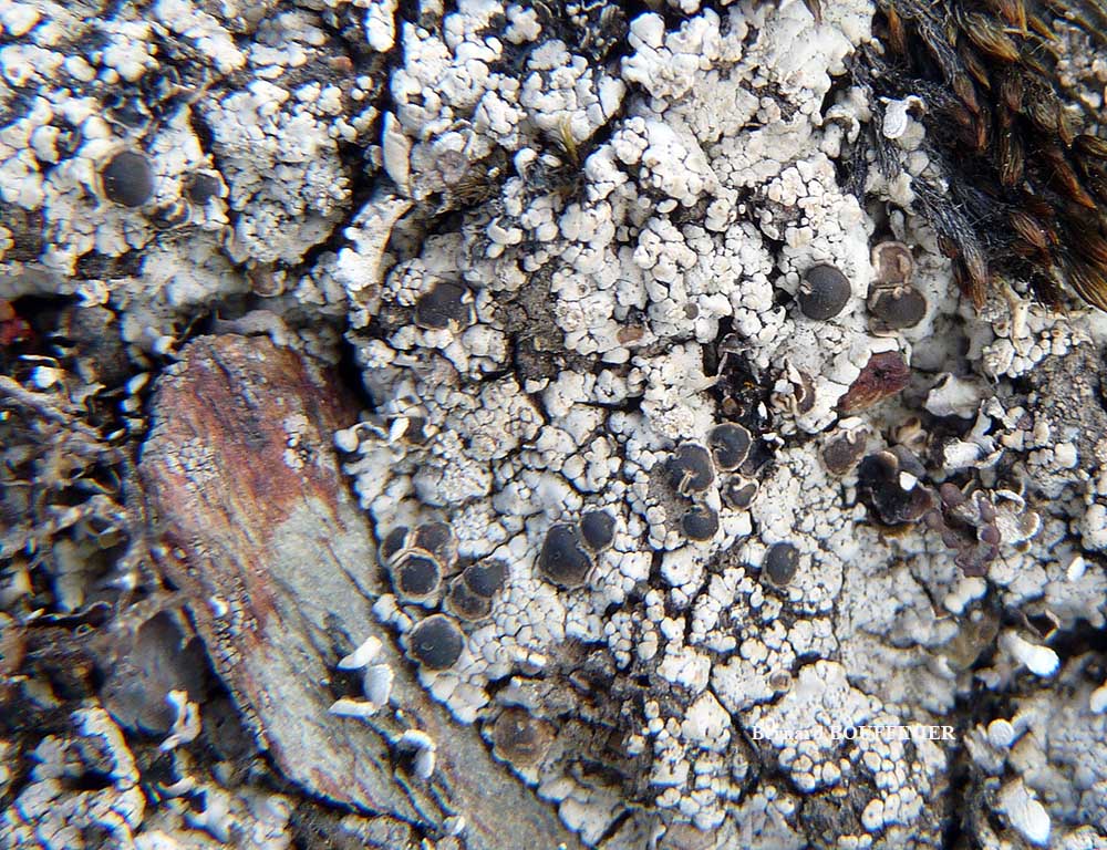
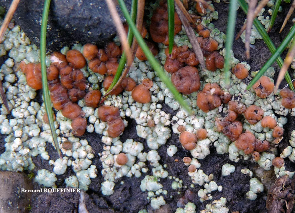
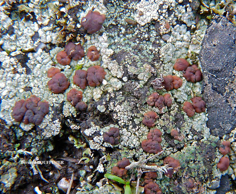
Bernard Bouffinier - Source: http://www.lichensmaritimes.org/index.php?task=fiche&lichen=122&lang=en
France, Cosquer
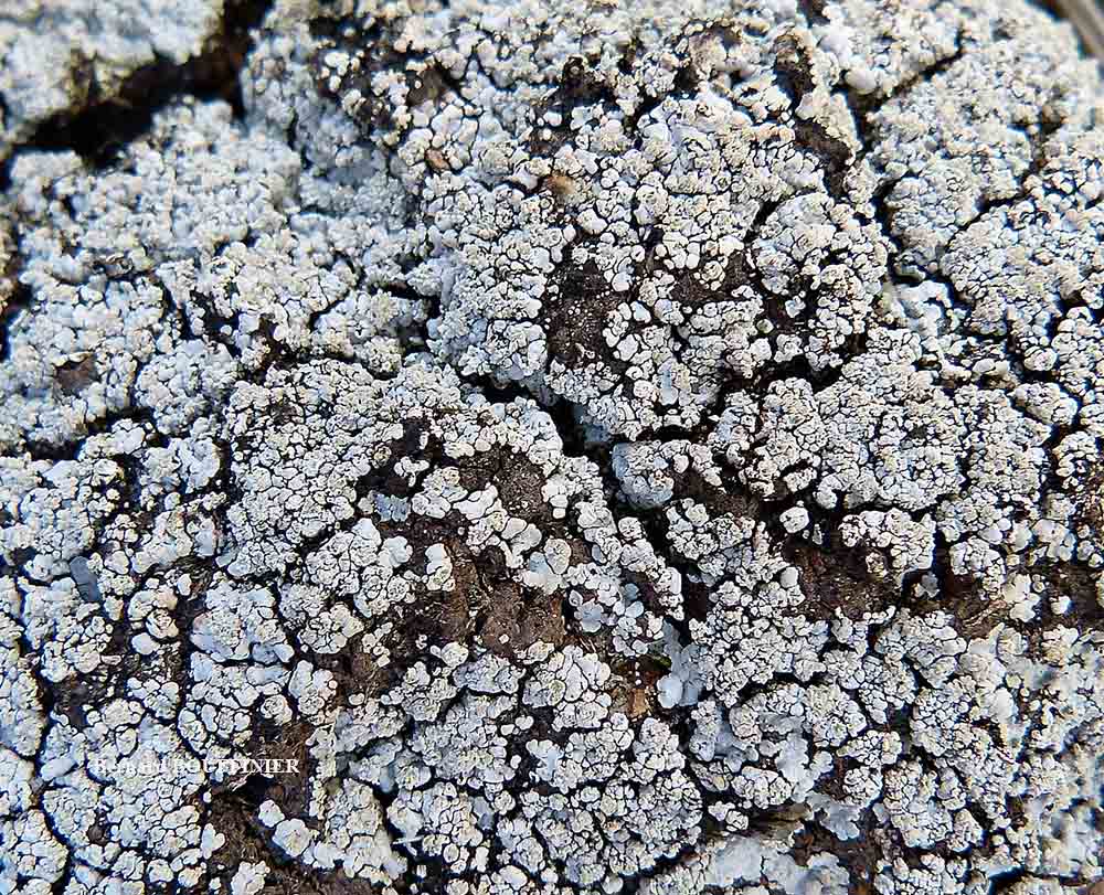
Bernard Bouffinier - Source: http://www.lichensmaritimes.org/index.php?task=fiche&lichen=122&lang=en
France, Cosquer

Bernard Bouffinier - Source: http://www.lichensmaritimes.org/index.php?task=fiche&lichen=122&lang=en
France, Cosquer
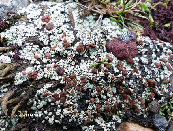
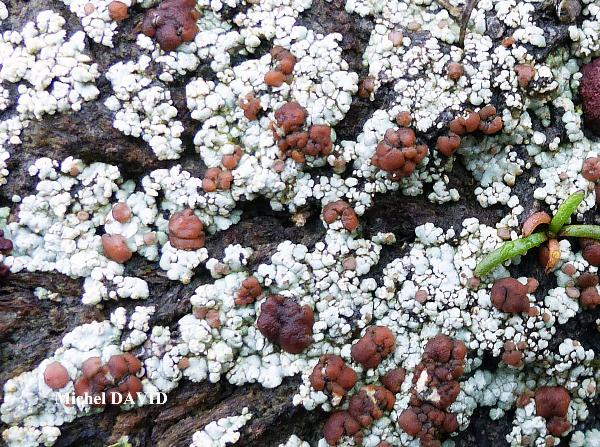
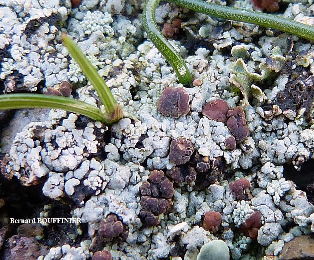
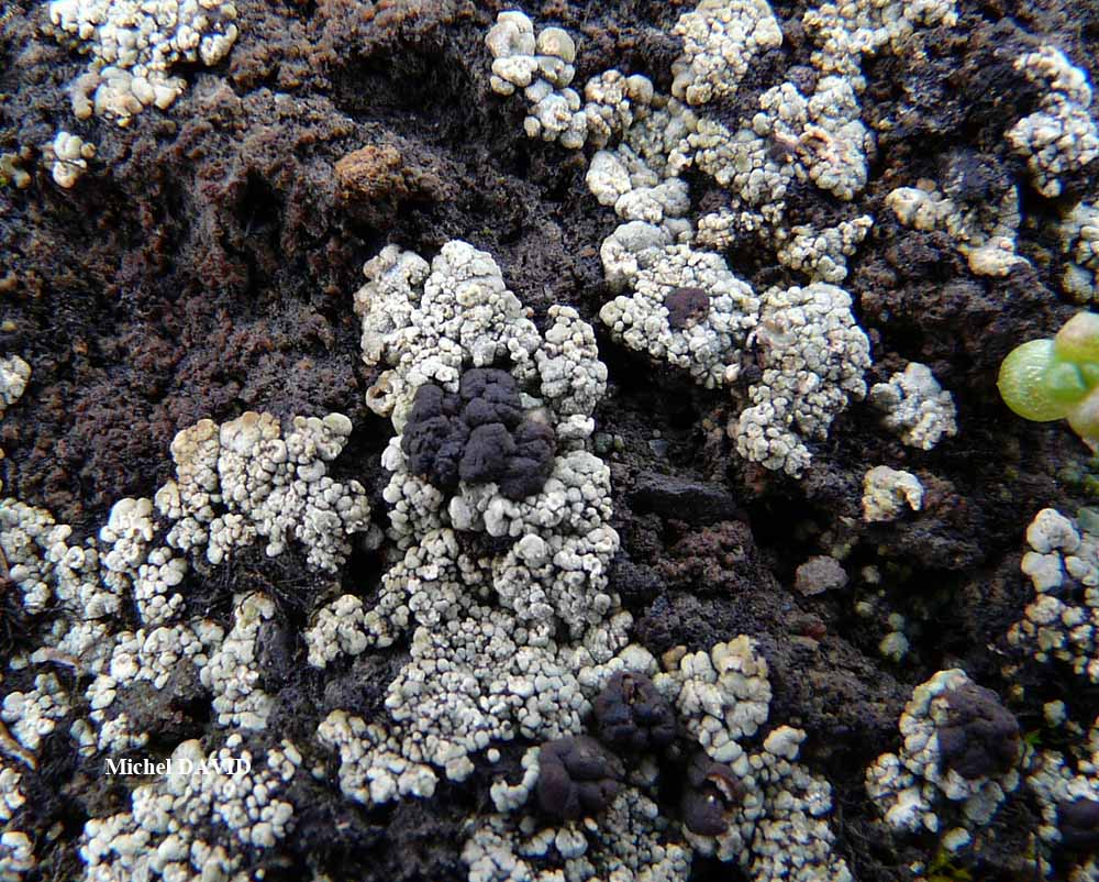
Michel David - Source: http://www.lichensmaritimes.org/index.php?task=fiche&lichen=122&lang=en
France, Pointe de Pen-Hir

Bernard Bouffinier - Source: http://www.lichensmaritimes.org/index.php?task=fiche&lichen=122&lang=en
France, Pointe de Pen-Hir

Bernard Bouffinier - Source: http://www.lichensmaritimes.org/index.php?task=fiche&lichen=122&lang=en
France, Pointe de Dinan
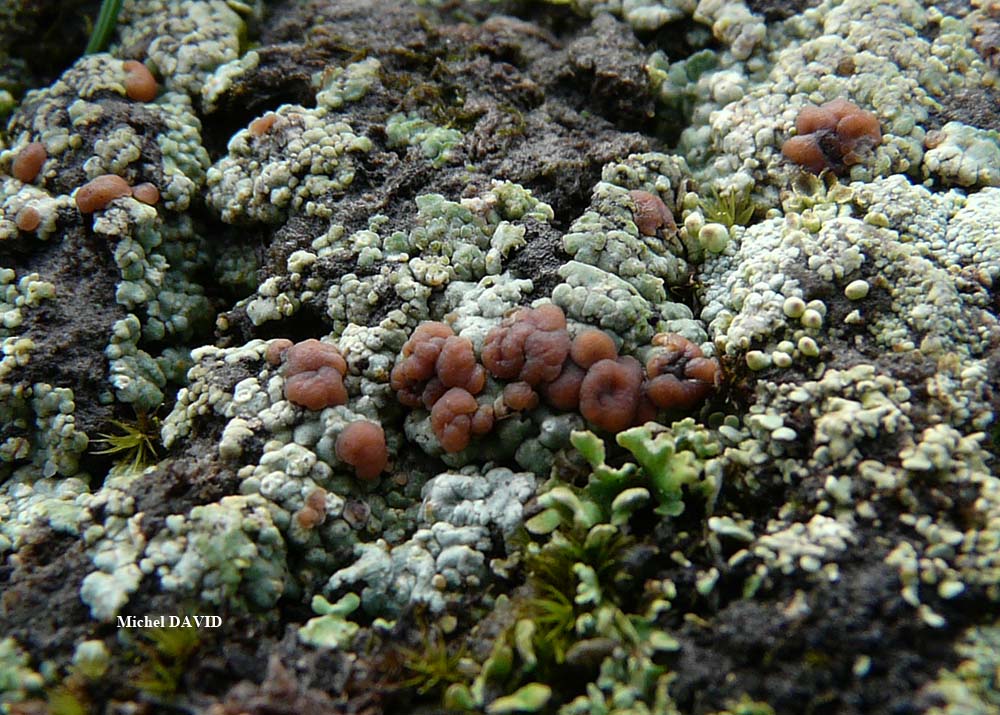
Michel David - Source: http://www.lichensmaritimes.org/index.php?task=fiche&lichen=122&lang=en
France, Kervijen
Michel David - Source: http://www.lichensmaritimes.org/index.php?task=fiche&lichen=122&lang=en
France, Pointe de Pen-Hir
Bernard Bouffinier - Source: http://www.lichensmaritimes.org/index.php?task=fiche&lichen=122&lang=en
France, Pointe de Pen-Hir

Bernard Bouffinier - Source: http://www.lichensmaritimes.org/index.php?task=fiche&lichen=122&lang=en
France, Pointe de Pen-Hir
Bernard Bouffinier - Source: http://www.lichensmaritimes.org/index.php?task=fiche&lichen=122&lang=en
France, Pointe de Pen-Hir
Bernard Bouffinier - Source: http://www.lichensmaritimes.org/index.php?task=fiche&lichen=122&lang=en
France, Pointe de Pen-Hir
Bernard Bouffinier - Source: http://www.lichensmaritimes.org/index.php?task=fiche&lichen=122&lang=en
France, Pointe de Pen-Hir
Bernard Bouffinier - Source: http://www.lichensmaritimes.org/index.php?task=fiche&lichen=122&lang=en
France, Pointe de Pen-Hir
Bernard Bouffinier - Source: http://www.lichensmaritimes.org/index.php?task=fiche&lichen=122&lang=en
France, Pointe de Pen-Hir
Bernard Bouffinier - Source: http://www.lichensmaritimes.org/index.php?task=fiche&lichen=122&lang=en
France, Pointe de Pen-Hir
Growth form: Crustose
Substrata: soil, terricolous mosses, and plant debris
Photobiont: green algae other than Trentepohlia
Reproductive strategy: mainly asexual, by isidia, or isidia-like structures (e.g. schizidia)
Commonnes-rarity: (info)
Alpine belt: absent
Subalpine belt: absent
Oromediterranean belt: absent
Montane belt: very rare
Submediterranean belt: extremely rare
Padanian area: absent
Humid submediterranean belt: very rare
Humid mediterranean belt: extremely rare
Dry mediterranean belt: absent
Predictive model
| Herbarium samples |

Leif Stridvall - Source: http://www.stridvall.se/la/galleries.php (Courtesy: Anita Stridvall)
Felix Schumm – CC BY-SA 4.0
[8484], Portugal, Madeira, Paúl da Serra, östlich Rabacal bei Urze, windgefegte Hochfläche, N 32°45.284, W 17°06.474, 1402 m. Leg. Schumm 12.04.2001, det. Aptroot 2011.
P.L. Nimis; Owner: Department of Life Sciences, University of Trieste
Herbarium: TSB (9909)
2001/12/01

Felix Schumm – CC BY-SA 4.0
[8484], Portugal, Madeira, Paúl da Serra, östlich Rabacal bei Urze, windgefegte Hochfläche, N 32°45.284, W 17°06.474, 1402 m. Leg. Schumm 12.04.2001, det. Aptroot 2011.
Felix Schumm – CC BY-SA 4.0
[8484], Portugal, Madeira, Paúl da Serra, östlich Rabacal bei Urze, windgefegte Hochfläche, N 32°45.284, W 17°06.474, 1402 m. Leg. Schumm 12.04.2001, det. Aptroot 2011.
Felix Schumm – CC BY-SA 4.0
[8484], Portugal, Madeira, Paúl da Serra, östlich Rabacal bei Urze, windgefegte Hochfläche, N 32°45.284, W 17°06.474, 1402 m. Leg. Schumm 12.04.2001, det. Aptroot 2011.
Felix Schumm – CC BY-SA 4.0
[8484], Portugal, Madeira, Paúl da Serra, östlich Rabacal bei Urze, windgefegte Hochfläche, N 32°45.284, W 17°06.474, 1402 m. Leg. Schumm 12.04.2001, det. Aptroot 2011.
Felix Schumm – CC BY-SA 4.0
[8484], Portugal, Madeira, Paúl da Serra, östlich Rabacal bei Urze, windgefegte Hochfläche, N 32°45.284, W 17°06.474, 1402 m. Leg. Schumm 12.04.2001, det. Aptroot 2011.
Felix Schumm – CC BY-SA 4.0
[8484], Portugal, Madeira, Paúl da Serra, östlich Rabacal bei Urze, windgefegte Hochfläche, N 32°45.284, W 17°06.474, 1402 m. Leg. Schumm 12.04.2001, det. Aptroot 2011.
Felix Schumm – CC BY-SA 4.0
[8484], Portugal, Madeira, Paúl da Serra, östlich Rabacal bei Urze, windgefegte Hochfläche, N 32°45.284, W 17°06.474, 1402 m. Leg. Schumm 12.04.2001, det. Aptroot 2011.
Felix Schumm – CC BY-SA 4.0
[8484], Portugal, Madeira, Paúl da Serra, östlich Rabacal bei Urze, windgefegte Hochfläche, N 32°45.284, W 17°06.474, 1402 m. Leg. Schumm 12.04.2001, det. Aptroot 2011.
Felix Schumm – CC BY-SA 4.0
[8484], Portugal, Madeira, Paúl da Serra, östlich Rabacal bei Urze, windgefegte Hochfläche, N 32°45.284, W 17°06.474, 1402 m. Leg. Schumm 12.04.2001, det. Aptroot 2011.
Felix Schumm – CC BY-SA 4.0
[8484], Portugal, Madeira, Paúl da Serra, östlich Rabacal bei Urze, windgefegte Hochfläche, N 32°45.284, W 17°06.474, 1402 m. Leg. Schumm 12.04.2001, det. Aptroot 2011.

Felix Schumm – CC BY-SA 4.0
[8484], Portugal, Madeira, Paúl da Serra, östlich Rabacal bei Urze, windgefegte Hochfläche, N 32°45.284, W 17°06.474, 1402 m. Leg. Schumm 12.04.2001, det. Aptroot 2011.
Felix Schumm – CC BY-SA 4.0
[8484], Portugal, Madeira, Paúl da Serra, östlich Rabacal bei Urze, windgefegte Hochfläche, N 32°45.284, W 17°06.474, 1402 m. Leg. Schumm 12.04.2001, det. Aptroot 2011.
Felix Schumm – CC BY-SA 4.0
[8484], Portugal, Madeira, Paúl da Serra, östlich Rabacal bei Urze, windgefegte Hochfläche, N 32°45.284, W 17°06.474, 1402 m. Leg. Schumm 12.04.2001, det. Aptroot 2011.
Felix Schumm – CC BY-SA 4.0
[8484], Portugal, Madeira, Paúl da Serra, östlich Rabacal bei Urze, windgefegte Hochfläche, N 32°45.284, W 17°06.474, 1402 m. Leg. Schumm 12.04.2001, det. Aptroot 2011.
Felix Schumm – CC BY-SA 4.0
[8484], Portugal, Madeira, Paúl da Serra, östlich Rabacal bei Urze, windgefegte Hochfläche, N 32°45.284, W 17°06.474, 1402 m. Leg. Schumm 12.04.2001, det. Aptroot 2011.
Felix Schumm – CC BY-SA 4.0
[8484], Portugal, Madeira, Paúl da Serra, östlich Rabacal bei Urze, windgefegte Hochfläche, N 32°45.284, W 17°06.474, 1402 m. Leg. Schumm 12.04.2001, det. Aptroot 2011.
Felix Schumm – CC BY-SA 4.0
[8484], Portugal, Madeira, Paúl da Serra, östlich Rabacal bei Urze, windgefegte Hochfläche, N 32°45.284, W 17°06.474, 1402 m. Leg. Schumm 12.04.2001, det. Aptroot 2011.

Felix Schumm – CC BY-SA 4.0
[8484], Portugal, Madeira, Paúl da Serra, östlich Rabacal bei Urze, windgefegte Hochfläche, N 32°45.284, W 17°06.474, 1402 m. Leg. Schumm 12.04.2001, det. Aptroot 2011.

Felix Schumm – CC BY-SA 4.0
[8484], Portugal, Madeira, Paúl da Serra, östlich Rabacal bei Urze, windgefegte Hochfläche, N 32°45.284, W 17°06.474, 1402 m. Leg. Schumm 12.04.2001, det. Aptroot 2011.
Felix Schumm – CC BY-SA 4.0
[8484], Portugal, Madeira, Paúl da Serra, östlich Rabacal bei Urze, windgefegte Hochfläche, N 32°45.284, W 17°06.474, 1402 m. Leg. Schumm 12.04.2001, det. Aptroot 2011.
Felix Schumm – CC BY-SA 4.0
[8484], Portugal, Madeira, Paúl da Serra, östlich Rabacal bei Urze, windgefegte Hochfläche, N 32°45.284, W 17°06.474, 1402 m. Leg. Schumm 12.04.2001, det. Aptroot 2011.

Felix Schumm – CC BY-SA 4.0
[8484], Portugal, Madeira, Paúl da Serra, östlich Rabacal bei Urze, windgefegte Hochfläche, N 32°45.284, W 17°06.474, 1402 m. Leg. Schumm 12.04.2001, det. Aptroot 2011.

Felix Schumm – CC BY-SA 4.0
[8484], Portugal, Madeira, Paúl da Serra, östlich Rabacal bei Urze, windgefegte Hochfläche, N 32°45.284, W 17°06.474, 1402 m. Leg. Schumm 12.04.2001, det. Aptroot 2011.

Felix Schumm – CC BY-SA 4.0
[8484], Portugal, Madeira, Paúl da Serra, östlich Rabacal bei Urze, windgefegte Hochfläche, N 32°45.284, W 17°06.474, 1402 m. Leg. Schumm 12.04.2001, det. Aptroot 2011.

Felix Schumm – CC BY-SA 4.0
[8484], Portugal, Madeira, Paúl da Serra, östlich Rabacal bei Urze, windgefegte Hochfläche, N 32°45.284, W 17°06.474, 1402 m. Leg. Schumm 12.04.2001, det. Aptroot 2011.
Felix Schumm – CC BY-SA 4.0
[8484], Portugal, Madeira, Paúl da Serra, östlich Rabacal bei Urze, windgefegte Hochfläche, N 32°45.284, W 17°06.474, 1402 m. Leg. Schumm 12.04.2001, det. Aptroot 2011.

Felix Schumm – CC BY-SA 4.0
[8484], Portugal, Madeira, Paúl da Serra, östlich Rabacal bei Urze, windgefegte Hochfläche, N 32°45.284, W 17°06.474, 1402 m. Leg. Schumm 12.04.2001, det. Aptroot 2011.

Felix Schumm – CC BY-SA 4.0
[8484], Portugal, Madeira, Paúl da Serra, östlich Rabacal bei Urze, windgefegte Hochfläche, N 32°45.284, W 17°06.474, 1402 m. Leg. Schumm 12.04.2001, det. Aptroot 2011.
Felix Schumm – CC BY-SA 4.0
[8484], Portugal, Madeira, Paúl da Serra, östlich Rabacal bei Urze, windgefegte Hochfläche, N 32°45.284, W 17°06.474, 1402 m. Leg. Schumm 12.04.2001, det. Aptroot 2011.
Felix Schumm – CC BY-SA 4.0
[8484], Portugal, Madeira, Paúl da Serra, östlich Rabacal bei Urze, windgefegte Hochfläche, N 32°45.284, W 17°06.474, 1402 m. Leg. Schumm 12.04.2001, det. Aptroot 2011.

Pier Luigi Nimis - CC BY-SA 4.0
TSB 20331

Pier Luigi Nimis - CC BY-SA 4.0
TSB 20331
Pier Luigi Nimis - CC BY-SA 4.0
TSB 13111

Pier Luigi Nimis - CC BY-SA 4.0
TSB 13111
P.L. Nimis CC BY-SA 4.0
TSB 2033

P.L. Nimis CC BY-SA 4.0
TSB 8532
P.L. Nimis CC BY-SA 4.0
TSB 13133
P.L. Nimis CC BY-SA 4.0
TSB 13133
P.L. Nimis CC BY-SA 4.0
TSB 13133
Bernard Bouffinier - Source: http://www.lichensmaritimes.org/index.php?task=fiche&lichen=122&lang=en
France, Cosquer
Bernard Bouffinier - Source: http://www.lichensmaritimes.org/index.php?task=fiche&lichen=122&lang=en
France, Cosquer
Bernard Bouffinier - Source: http://www.lichensmaritimes.org/index.php?task=fiche&lichen=122&lang=en
France, Cosquer
Michel David - Source: http://www.lichensmaritimes.org/index.php?task=fiche&lichen=122&lang=en
France, Pointe de Pen-Hir
Bernard Bouffinier - Source: http://www.lichensmaritimes.org/index.php?task=fiche&lichen=122&lang=en
France, Pointe de Pen-Hir
Bernard Bouffinier - Source: http://www.lichensmaritimes.org/index.php?task=fiche&lichen=122&lang=en
France, Pointe de Dinan

Michel David - Source: http://www.lichensmaritimes.org/index.php?task=fiche&lichen=122&lang=en
France, Kervijen
Michel David - Source: http://www.lichensmaritimes.org/index.php?task=fiche&lichen=122&lang=en
France, Pointe de Pen-Hir
Bernard Bouffinier - Source: http://www.lichensmaritimes.org/index.php?task=fiche&lichen=122&lang=en
France, Pointe de Pen-Hir
Bernard Bouffinier - Source: http://www.lichensmaritimes.org/index.php?task=fiche&lichen=122&lang=en
France, Pointe de Pen-Hir
Bernard Bouffinier - Source: http://www.lichensmaritimes.org/index.php?task=fiche&lichen=122&lang=en
France, Pointe de Pen-Hir

Bernard Bouffinier - Source: http://www.lichensmaritimes.org/index.php?task=fiche&lichen=122&lang=en
France, Pointe de Pen-Hir

Bernard Bouffinier - Source: http://www.lichensmaritimes.org/index.php?task=fiche&lichen=122&lang=en
France, Pointe de Pen-Hir

Bernard Bouffinier - Source: http://www.lichensmaritimes.org/index.php?task=fiche&lichen=122&lang=en
France, Pointe de Pen-Hir

Bernard Bouffinier - Source: http://www.lichensmaritimes.org/index.php?task=fiche&lichen=122&lang=en
France, Pointe de Pen-Hir