Micarea lithinella (Nyl.) Hedl.
Bih. K. Svenska Vetensk- Akad. Handl., 3, 18: 78, 1892. Basionym: Lecidea lithinella Nyl. - Flora, 45: 464, 1862.
Synonyms: Biatora meiocarpoides (Nyl.) Arnold; Lecidea holsatica Erichsen; Lecidea lauenburgensis Erichsen; Lecidea meiocarpoides Nyl.
Distribution: N - TAA (Dalla Torre & Sarnthein 1902).
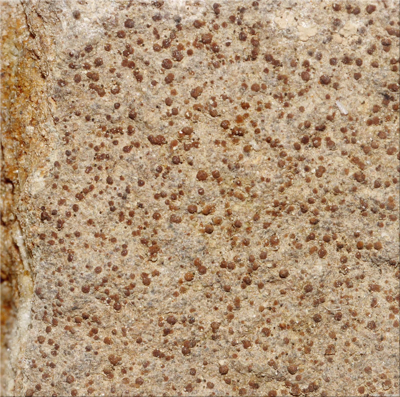
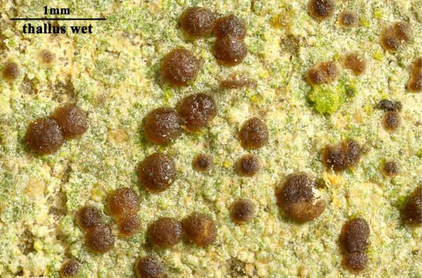
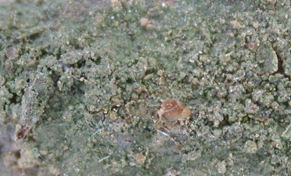
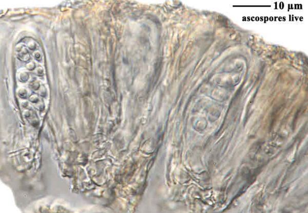
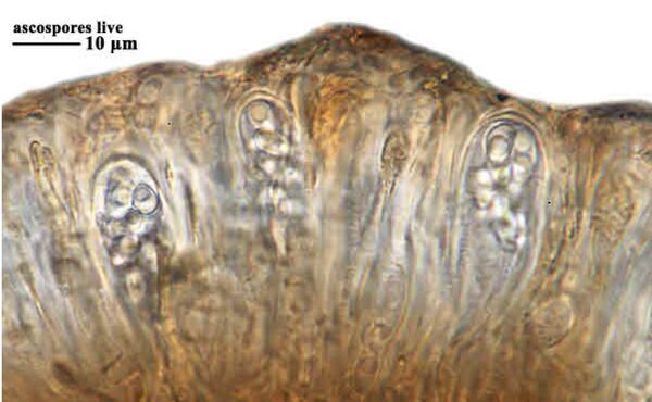
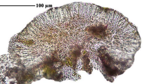
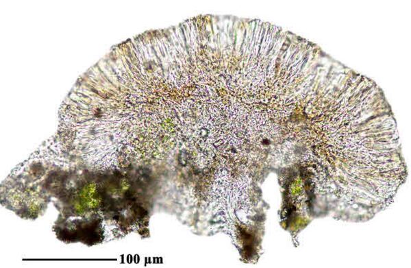
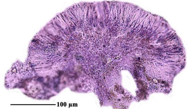
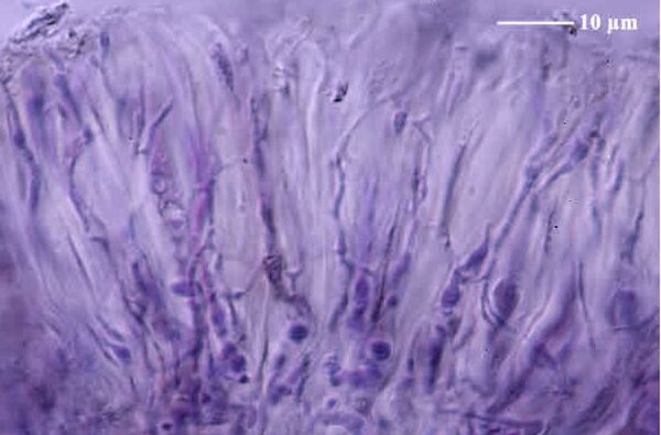
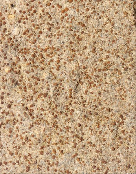
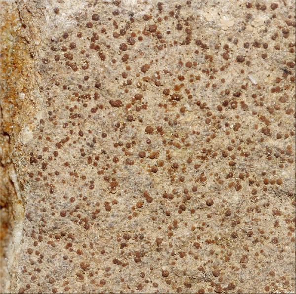
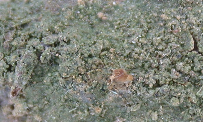
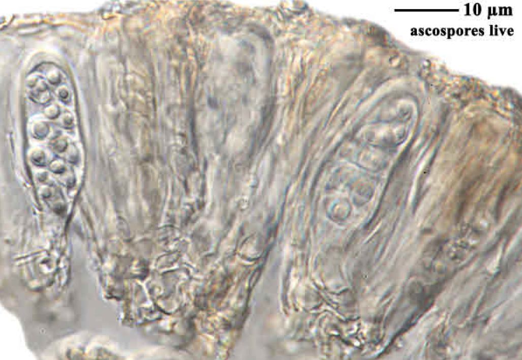
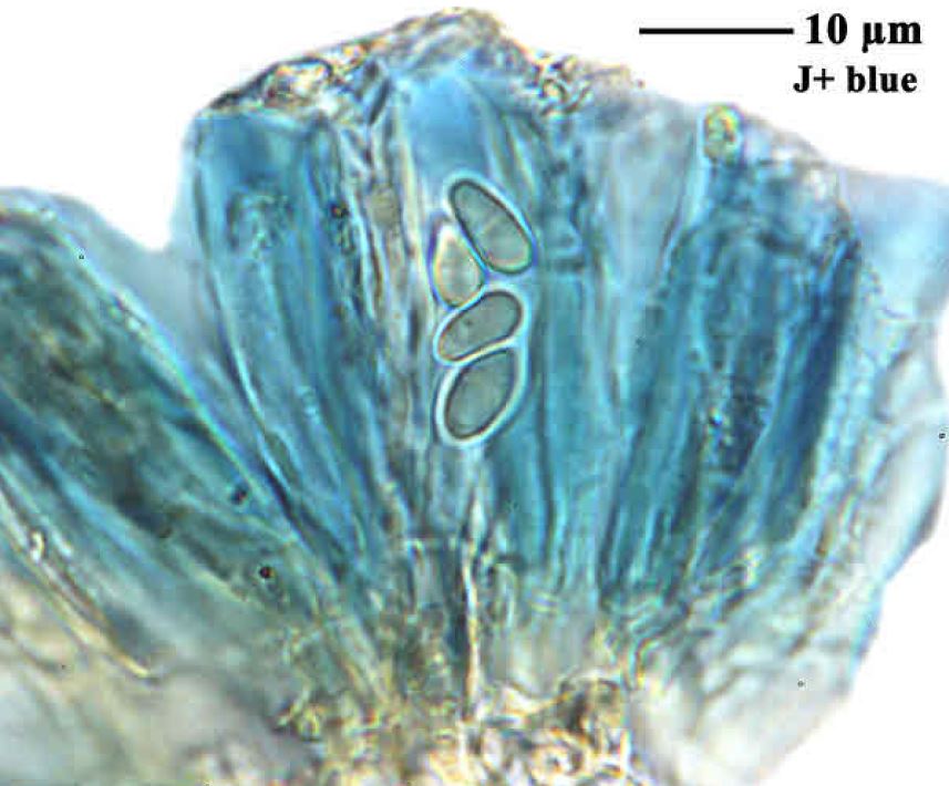
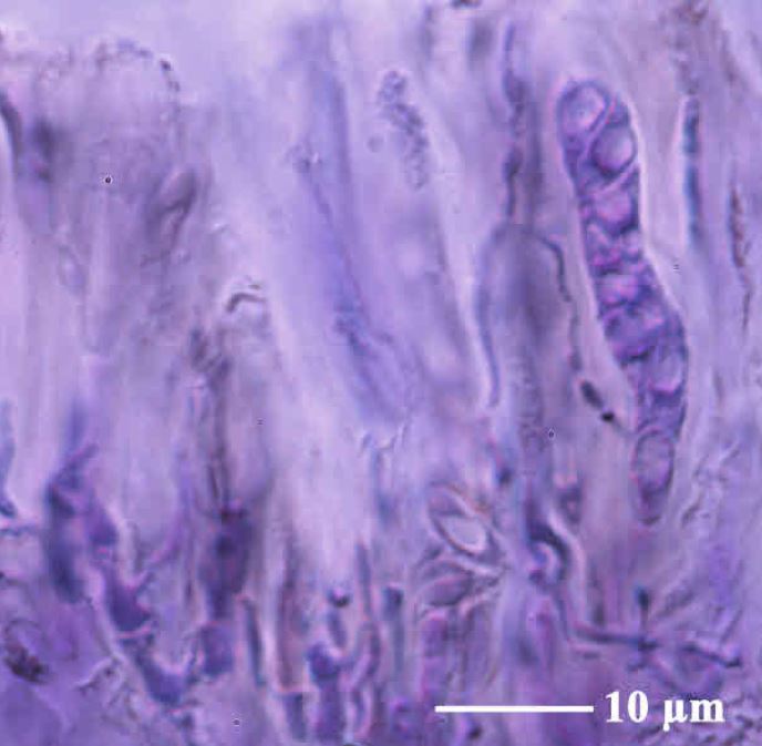
Description: Thallus crustose, endosubstratic and indistinct or thinly episubstratic and whitish, finely granulose. Apothecia micareoid, 0.1-0.4 mm across, whitish, straw-coloured or pale orange, only occasionally orange-brown, adnate, with a convex disc and without a proper margin. Proper exciple poorly developed, usually indistinct; epithecium colourless of very pale yellow, K-, N-; hymenium colourless, 30-50 μm high; paraphyses colourless. of two types: a) scanty, sparingly branched in upper part, 0.7-1 μm thick, non-septate, b) 3-3.5 μm thick, moniliform, distinctly septate, simple or occasionally forked; hypothecium pale yellow to pale brown. Asci 8-spored, clavate to cylindrical-clavate, in K/I with a blue outer layer and apical dome and unstained wall, the dome with an apical cushion. Ascospores 1-celled, hyaline, ellipsoid to subglobose, or pointed at one end, (5-)6-8(-10) x 2.5-4(-5) µm. Pycnidia rare, inconspicuous, immersed and sometimes visible as whitish, flat dots with gaping ostioles, the walls hyaline. Conidia narrowly cylindrical, 4-5.5 x 1-1.3 μm. Photobiont micareoid, the cells 3.5-6(-6.5) μm wide. Spot tests: thallus K-, C-, KC-, P-, UV-. Chemistry: without lichen substances. Note: a pioneer species found on compact siliceous rocks, often on pebbles, more rarely on soil in rather sheltered situations, such as in open forests, mostly below the subalpine belt; known from South Tyrol, and also reported from the Alps of Switzerland and Austria, perhaps more widespread in the Italian Alps.
Growth form: Crustose
Substrata: rocks
Photobiont: green algae other than Trentepohlia
Reproductive strategy: mainly sexual
Pioneer species
Commonnes-rarity: (info)
Alpine belt: absent
Subalpine belt: absent
Oromediterranean belt: absent
Montane belt: extremely rare
Submediterranean belt: extremely rare
Padanian area: absent
Humid submediterranean belt: absent
Humid mediterranean belt: absent
Dry mediterranean belt: absent
Predictive model

Felix Schumm – CC BY-SA 4.0
[19244], Germany, Württemberg, Kreis Göppingen, westlich der Gemeindehalle von Wangen, auf kleinen Sandsteinchen am Wegrand im Mischwald, 48°43.883' N, 9°35.856' E, 439 m. Leg. et det. F. Schumm 08.08.2014.
Author: André Aptroot. Source: http://www.tropicallichens.net/ CC BY-SA-NC
Felix Schumm – CC BY-SA 4.0
[19244], Germany, Württemberg, Kreis Göppingen, westlich der Gemeindehalle von Wangen, auf kleinen Sandsteinchen am Wegrand im Mischwald, 48°43.883' N, 9°35.856' E, 439 m. Leg. et det. F. Schumm 08.08.2014.
Felix Schumm – CC BY-SA 4.0
[19244], Germany, Württemberg, Kreis Göppingen, westlich der Gemeindehalle von Wangen, auf kleinen Sandsteinchen am Wegrand im Mischwald, 48°43.883' N, 9°35.856' E, 439 m. Leg. et det. F. Schumm 08.08.2014.
Felix Schumm – CC BY-SA 4.0
[19244], Germany, Württemberg, Kreis Göppingen, westlich der Gemeindehalle von Wangen, auf kleinen Sandsteinchen am Wegrand im Mischwald, 48°43.883' N, 9°35.856' E, 439 m. Leg. et det. F. Schumm 08.08.2014.
Felix Schumm – CC BY-SA 4.0
[19244], Germany, Württemberg, Kreis Göppingen, westlich der Gemeindehalle von Wangen, auf kleinen Sandsteinchen am Wegrand im Mischwald, 48°43.883' N, 9°35.856' E, 439 m. Leg. et det. F. Schumm 08.08.2014.

Felix Schumm – CC BY-SA 4.0
[19244], Germany, Württemberg, Kreis Göppingen, westlich der Gemeindehalle von Wangen, auf kleinen Sandsteinchen am Wegrand im Mischwald, 48°43.883' N, 9°35.856' E, 439 m. Leg. et det. F. Schumm 08.08.2014.
Felix Schumm – CC BY-SA 4.0
[19244], Germany, Württemberg, Kreis Göppingen, westlich der Gemeindehalle von Wangen, auf kleinen Sandsteinchen am Wegrand im Mischwald, 48°43.883' N, 9°35.856' E, 439 m. Leg. et det. F. Schumm 08.08.2014.

Felix Schumm – CC BY-SA 4.0
[19244], Germany, Württemberg, Kreis Göppingen, westlich der Gemeindehalle von Wangen, auf kleinen Sandsteinchen am Wegrand im Mischwald, 48°43.883' N, 9°35.856' E, 439 m. Leg. et det. F. Schumm 08.08.2014.
Felix Schumm – CC BY-SA 4.0
[19244], Germany, Württemberg, Kreis Göppingen, westlich der Gemeindehalle von Wangen, auf kleinen Sandsteinchen am Wegrand im Mischwald, 48°43.883' N, 9°35.856' E, 439 m. Leg. et det. F. Schumm 08.08.2014.
Walter Obermayer - CC BY-SA 4.0 - Source: http://lichens-of-noricum.uni-graz.at/
Walter Obermayer - CC BY-SA 4.0 - Source: http://lichens-of-noricum.uni-graz.at/
Growth form: Crustose
Substrata: rocks
Photobiont: green algae other than Trentepohlia
Reproductive strategy: mainly sexual
Pioneer species
Commonnes-rarity: (info)
Alpine belt: absent
Subalpine belt: absent
Oromediterranean belt: absent
Montane belt: extremely rare
Submediterranean belt: extremely rare
Padanian area: absent
Humid submediterranean belt: absent
Humid mediterranean belt: absent
Dry mediterranean belt: absent
Predictive model
 DOLICHENS

Felix Schumm – CC BY-SA 4.0
[19244], Germany, Württemberg, Kreis Göppingen, westlich der Gemeindehalle von Wangen, auf kleinen Sandsteinchen am Wegrand im Mischwald, 48°43.883' N, 9°35.856' E, 439 m. Leg. et det. F. Schumm 08.08.2014.
Author: André Aptroot. Source: http://www.tropicallichens.net/ CC BY-SA-NC
Felix Schumm – CC BY-SA 4.0
[19244], Germany, Württemberg, Kreis Göppingen, westlich der Gemeindehalle von Wangen, auf kleinen Sandsteinchen am Wegrand im Mischwald, 48°43.883' N, 9°35.856' E, 439 m. Leg. et det. F. Schumm 08.08.2014.

Felix Schumm – CC BY-SA 4.0
[19244], Germany, Württemberg, Kreis Göppingen, westlich der Gemeindehalle von Wangen, auf kleinen Sandsteinchen am Wegrand im Mischwald, 48°43.883' N, 9°35.856' E, 439 m. Leg. et det. F. Schumm 08.08.2014.

Felix Schumm – CC BY-SA 4.0
[19244], Germany, Württemberg, Kreis Göppingen, westlich der Gemeindehalle von Wangen, auf kleinen Sandsteinchen am Wegrand im Mischwald, 48°43.883' N, 9°35.856' E, 439 m. Leg. et det. F. Schumm 08.08.2014.

Felix Schumm – CC BY-SA 4.0
[19244], Germany, Württemberg, Kreis Göppingen, westlich der Gemeindehalle von Wangen, auf kleinen Sandsteinchen am Wegrand im Mischwald, 48°43.883' N, 9°35.856' E, 439 m. Leg. et det. F. Schumm 08.08.2014.
Felix Schumm – CC BY-SA 4.0
[19244], Germany, Württemberg, Kreis Göppingen, westlich der Gemeindehalle von Wangen, auf kleinen Sandsteinchen am Wegrand im Mischwald, 48°43.883' N, 9°35.856' E, 439 m. Leg. et det. F. Schumm 08.08.2014.

Felix Schumm – CC BY-SA 4.0
[19244], Germany, Württemberg, Kreis Göppingen, westlich der Gemeindehalle von Wangen, auf kleinen Sandsteinchen am Wegrand im Mischwald, 48°43.883' N, 9°35.856' E, 439 m. Leg. et det. F. Schumm 08.08.2014.
Felix Schumm – CC BY-SA 4.0
[19244], Germany, Württemberg, Kreis Göppingen, westlich der Gemeindehalle von Wangen, auf kleinen Sandsteinchen am Wegrand im Mischwald, 48°43.883' N, 9°35.856' E, 439 m. Leg. et det. F. Schumm 08.08.2014.

Felix Schumm – CC BY-SA 4.0
[19244], Germany, Württemberg, Kreis Göppingen, westlich der Gemeindehalle von Wangen, auf kleinen Sandsteinchen am Wegrand im Mischwald, 48°43.883' N, 9°35.856' E, 439 m. Leg. et det. F. Schumm 08.08.2014.
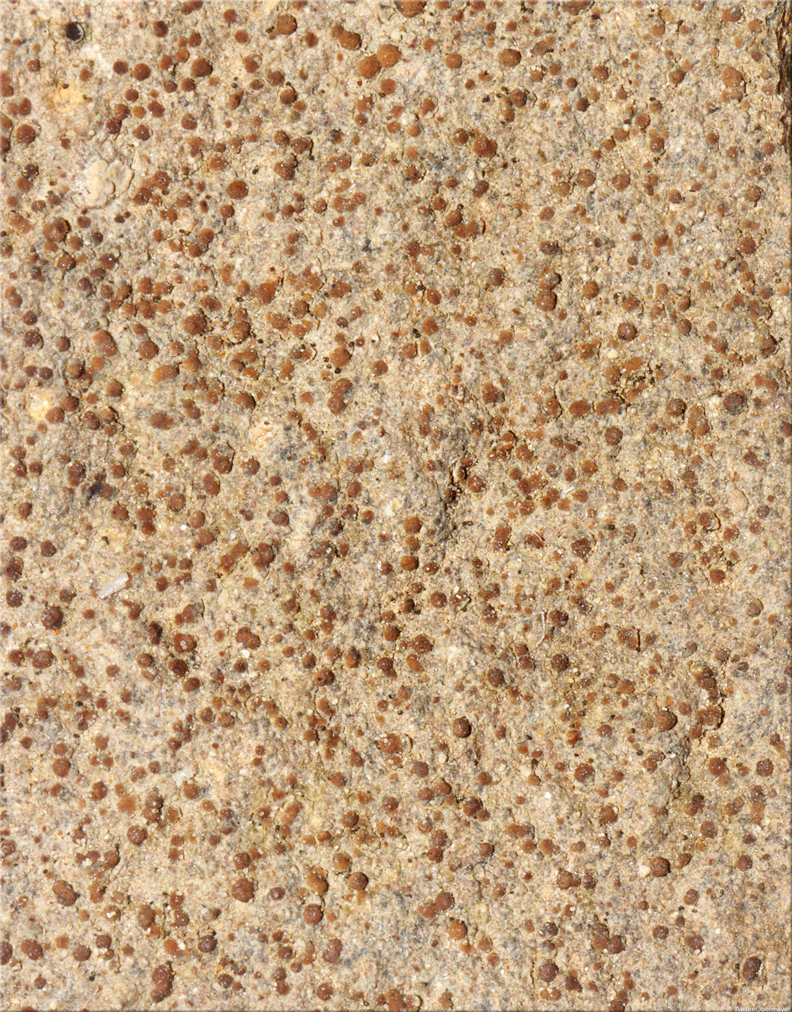
Walter Obermayer - CC BY-SA 4.0 - Source: http://lichens-of-noricum.uni-graz.at/