Opegrapha dolomitica (Arnold) Torrente & Egea
Clauzade & Cl. Roux ex Torrente & Egea, Bibl. Lichenol., 32: 146, 1989. Basionym: Opegrapha rupestris var. dolomitica Arnold - Flora, 43: 78, 1860.
Synonyms: Opegrapha saxicola auct. non Ach.; Opegrapha saxicola var. dolomitica (Arnold) V. Wirth
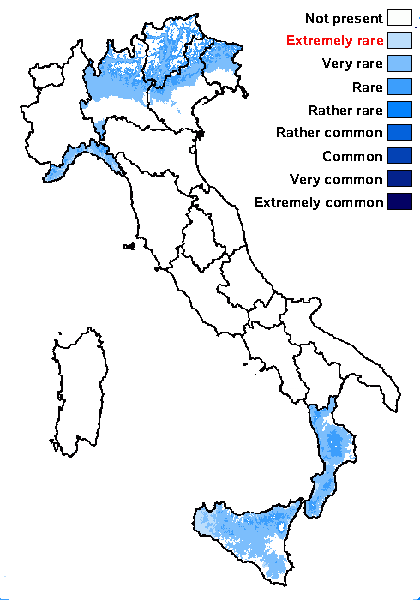
Distribution: N - Frl (Breuss 2008, Hafellner 2022), Ven (Nascimbene & Marini 2007, Nascimbene 2008c), TAA (Nascimbene 2008b, Nascimbene & al. 2022), Lomb (Brackel 2013), Lig. S - Cal (Puntillo 1996), Si.
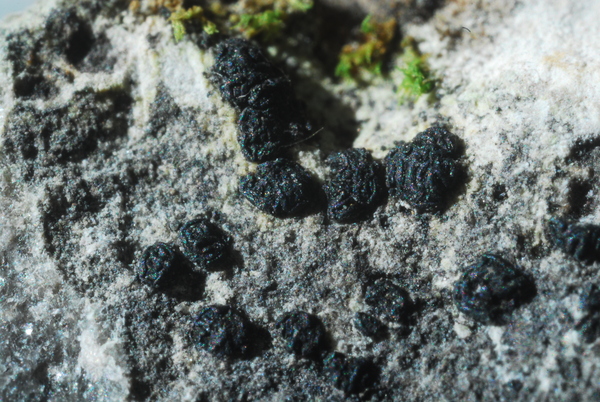
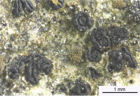
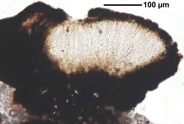
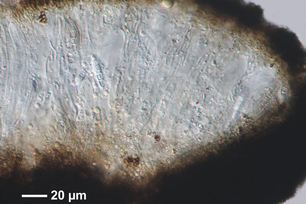
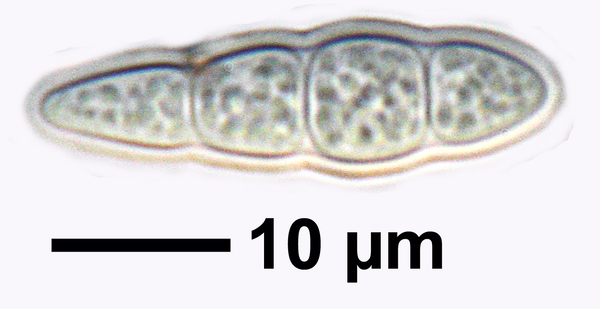
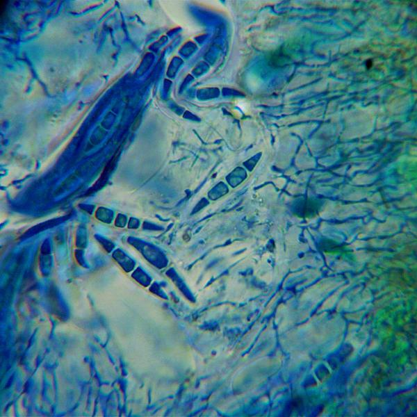
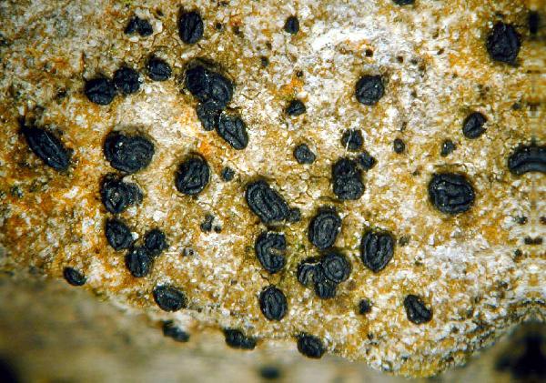
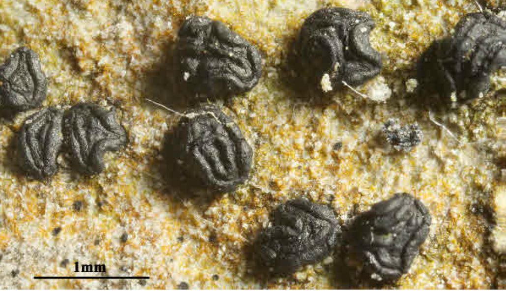
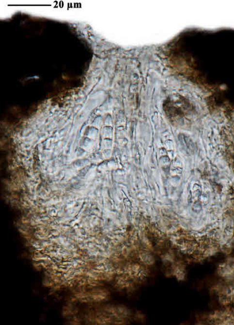
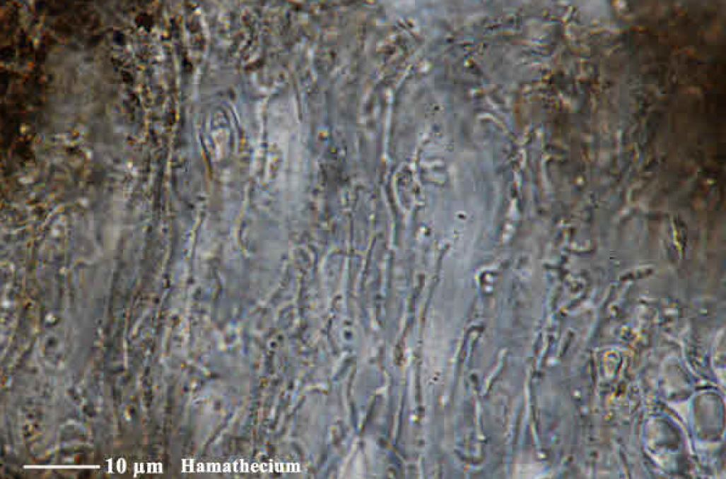
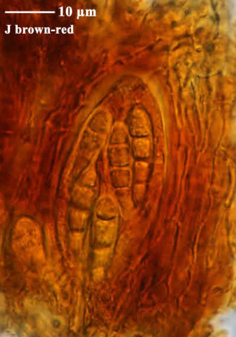
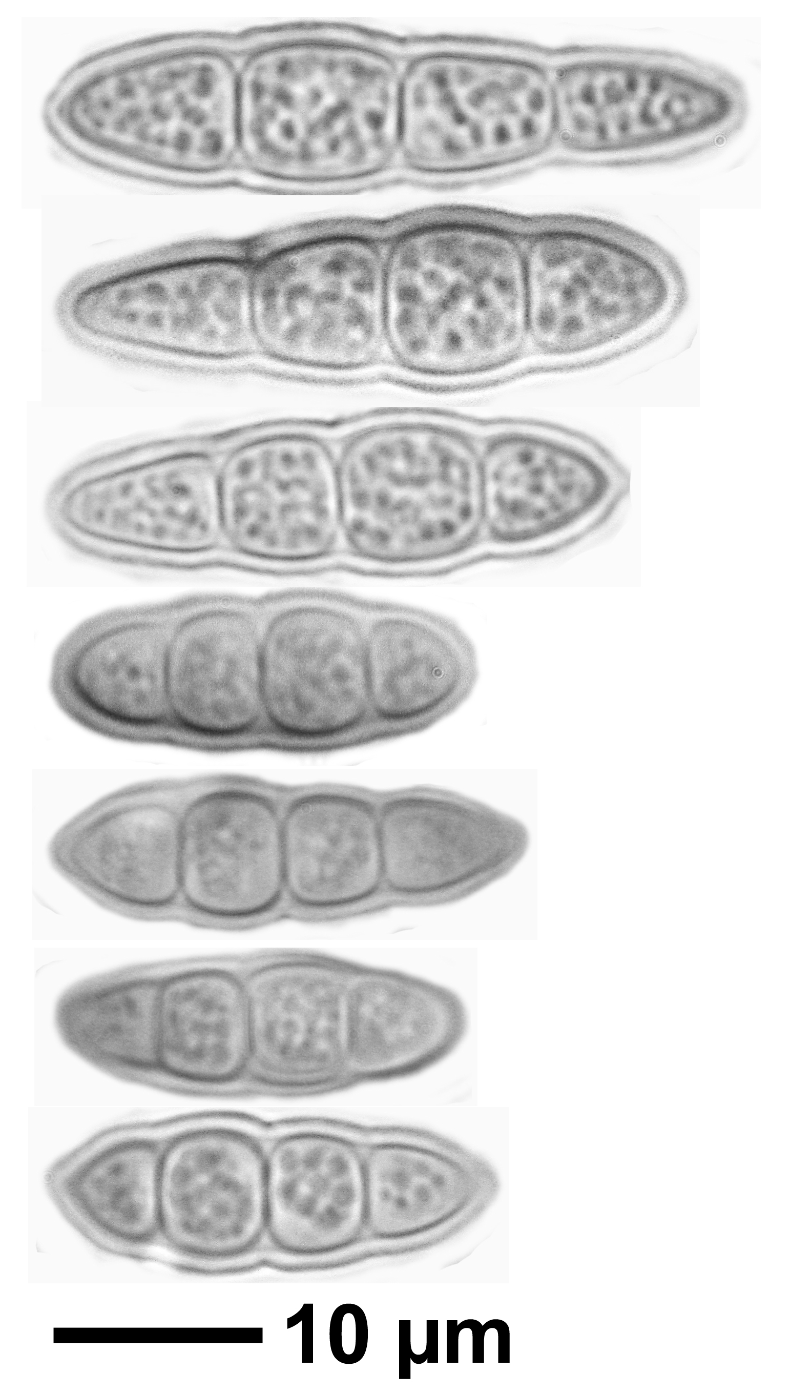
Description: Thallus crustose, endosubstratic or very thinly episubstratic, grey, grey-white, creamy white or pale reddish brown, smooth or faintly cracked, often poorly evident. Apothecia lirelliform, elliptical to elongate, mostly straight and simple, rarely curved and branched when old, (0.2-)0.5-2(-3) x 0.15–0.3(-0.5) mm, sessile to semi-immersed, solitary or clustered, with a slit-like, longitudinally furrowed or gnarled-subgyrose disc and a thick, persistent proper margin. Proper exciple black, carbonized, extending below the hymenium, 40-60 μm thick laterally and 80-150 μm at the base, K-; epithecium brown, K-; hymenium colourless, (50-)90-120 μm high, I+ reddish throughout; hypothecium 20–25 μm high. Asci 8-spored, broadly club-shaped, the inner layer of endoascus amyloid in upper part, with a reduced ring and ocular chamber (Varia-type). Ascospores 3(-4)-septate, often slightly constricted at septa, hyaline, ellipsoid to clavate, (16-)20-29(-33) x (4-)5-8 μm, with a 0.5-0.7(-1) μm thick perispore. Pycnidia black, more or less immersed. Conidia bacilliform, straight, 4–6 x 0.5-0.7 μm. Photobiont trentepohlioid. Spot tests: K-, C-, KC-, P-, UV-. Chemistry: without lichen substances.Note: on vertical or rain-sheltered surfaces of dolomitic rocks and (more rarely) of limestone, with a wide altitudinal range.
Growth form: Crustose
Substrata: rocks
Photobiont: Trentepohlia
Reproductive strategy: mainly sexual
In underhangs rarely wetted by rain
Commonnes-rarity: (info)
Alpine belt: absent
Subalpine belt: absent
Oromediterranean belt: absent
Montane belt: rare
Submediterranean belt: very rare
Padanian area: absent
Humid submediterranean belt: very rare
Humid mediterranean belt: extremely rare
Dry mediterranean belt: absent
Predictive model
Herbarium samples

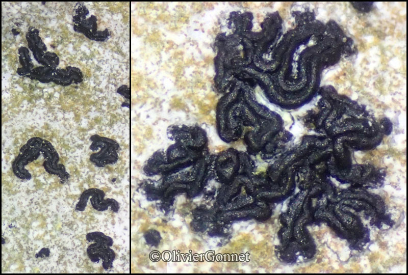
Courtesy Danièle et Olivier Gonnet - Source: https://www.afl-lichenologie.fr/Photos_AFL/Photos_AFL_O/Texte_O/Opegrapha_dolomitica.htm
France

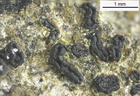
Domenico Puntillo; Owner: Domenico Puntillo
Italy

Felix Schumm – CC BY-SA 4.0
[16685], Germany, Baden-Württemberg, Schwäbische Alb, Kreis Heidenheim, Steinheim a. Albuch, Wental, schattige, feuchte Kalkfelsen im Wald nahe dem Gnannenstein, 48.70783° N, 10.03095° E, 580 m. Leg. et det. Schumm 19.09.2010.
Felix Schumm – CC BY-SA 4.0
[16685], Germany, Baden-Württemberg, Schwäbische Alb, Kreis Heidenheim, Steinheim a. Albuch, Wental, schattige, feuchte Kalkfelsen im Wald nahe dem Gnannenstein, 48.70783° N, 10.03095° E, 580 m. Leg. et det. Schumm 19.09.2010.
Felix Schumm – CC BY-SA 4.0
[16685], Germany, Baden-Württemberg, Schwäbische Alb, Kreis Heidenheim, Steinheim a. Albuch, Wental, schattige, feuchte Kalkfelsen im Wald nahe dem Gnannenstein, 48.70783° N, 10.03095° E, 580 m. Leg. et det. Schumm 19.09.2010.

Domenico Puntillo; Owner: Domenico Puntillo
Italy

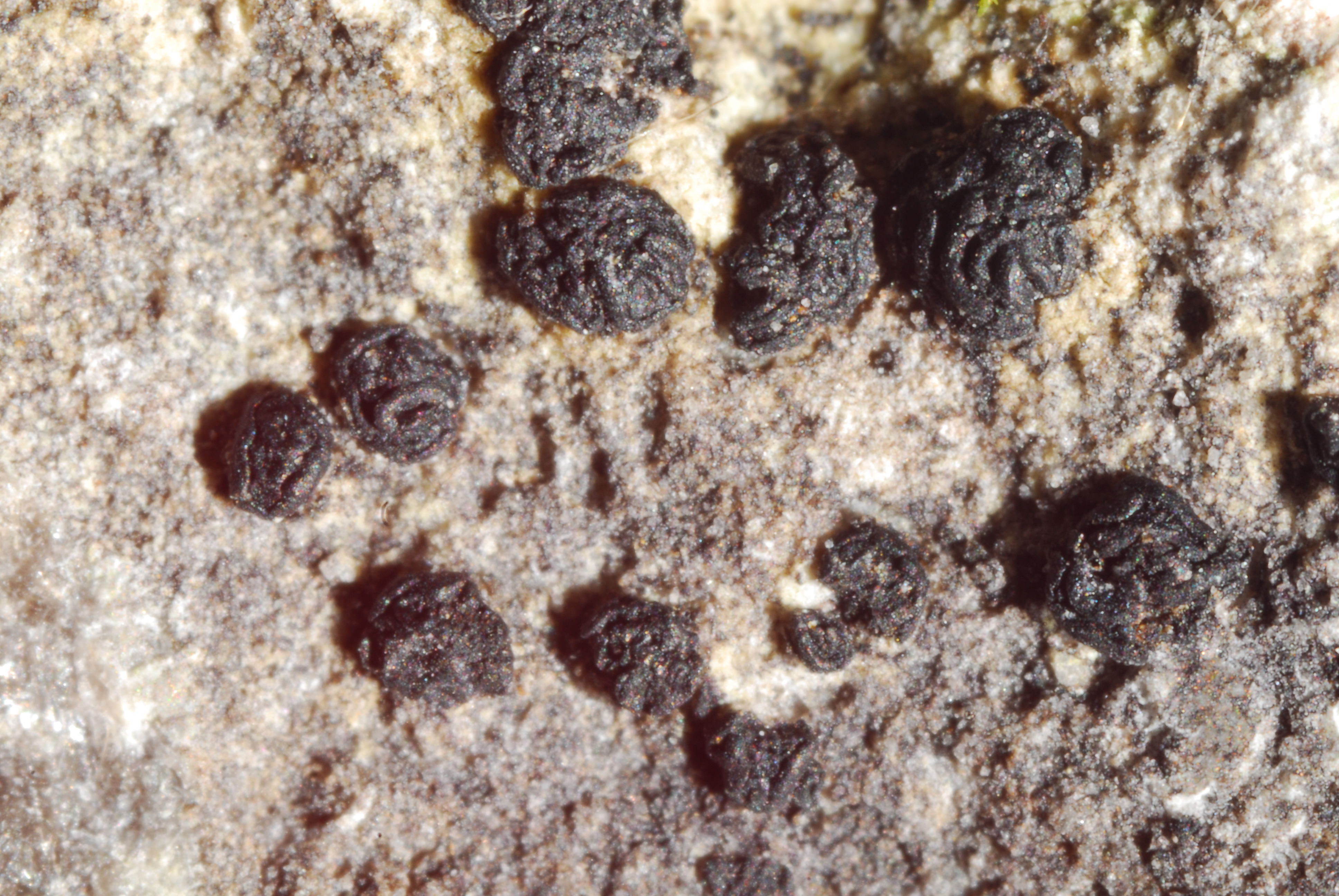
Felix Schumm – CC BY-SA 4.0
[19296], Germany, Bayern, Ammergauer Alpen, Wank, 47.50645° N, 11.14142° E, 1640 m, auf Kalkstein. Leg. F. Schumm, U. Schwarz & M. Guwak, Aug. 2014. Det F. Schumm 2014
Unusual form
Felix Schumm – CC BY-SA 4.0
[19296], Germany, Bayern, Ammergauer Alpen, Wank, 47.50645° N, 11.14142° E, 1640 m, auf Kalkstein. Leg. F. Schumm, U. Schwarz & M. Guwak, Aug. 2014. Det F. Schumm 2014
Unusual form
Felix Schumm – CC BY-SA 4.0
[19296], Germany, Bayern, Ammergauer Alpen, Wank, 47.50645° N, 11.14142° E, 1640 m, auf Kalkstein. Leg. F. Schumm, U. Schwarz & M. Guwak, Aug. 2014. Det F. Schumm 2014
Unusual form

Felix Schumm – CC BY-SA 4.0
[19296], Germany, Bayern, Ammergauer Alpen, Wank, 47.50645° N, 11.14142° E, 1640 m, auf Kalkstein. Leg. F. Schumm, U. Schwarz & M. Guwak, Aug. 2014. Det F. Schumm 2014
Unusual form
Felix Schumm – CC BY-SA 4.0
[19296], Germany, Bayern, Ammergauer Alpen, Wank, 47.50645° N, 11.14142° E, 1640 m, auf Kalkstein. Leg. F. Schumm, U. Schwarz & M. Guwak, Aug. 2014. Det F. Schumm 2014
Unusual form
Felix Schumm – CC BY-SA 4.0
[19296], Germany, Bayern, Ammergauer Alpen, Wank, 47.50645° N, 11.14142° E, 1640 m, auf Kalkstein. Leg. F. Schumm, U. Schwarz & M. Guwak, Aug. 2014. Det F. Schumm 2014
Unusual form
Felix Schumm – CC BY-SA 4.0
[19296], Germany, Bayern, Ammergauer Alpen, Wank, 47.50645° N, 11.14142° E, 1640 m, auf Kalkstein. Leg. F. Schumm, U. Schwarz & M. Guwak, Aug. 2014. Det F. Schumm 2014
Unusual form

Felix Schumm – CC BY-SA 4.0
[19296], Germany, Bayern, Ammergauer Alpen, Wank, 47.50645° N, 11.14142° E, 1640 m, auf Kalkstein. Leg. F. Schumm, U. Schwarz & M. Guwak, Aug. 2014. Det F. Schumm 2014
Unusual form

Felix Schumm – CC BY-SA 4.0
[19296], Germany, Bayern, Ammergauer Alpen, Wank, 47.50645° N, 11.14142° E, 1640 m, auf Kalkstein. Leg. F. Schumm, U. Schwarz & M. Guwak, Aug. 2014. Det F. Schumm 2014
Unusual form
Felix Schumm CC BY-SA 4.0
[16685], Germany, Baden-Württemberg, Schwäbische Alb, Kreis Heidenheim, Steinheim a. Albuch, Wental, schattige, feuchte Kalkfelsen im Wald nahe dem Gnannenstein, 48.70783° N, 10.03095° E, 580 m. Leg. et det. Schumm 19.09.2010.
Felix Schumm CC BY-SA 4.0
[16685], Germany, Baden-Württemberg, Schwäbische Alb, Kreis Heidenheim, Steinheim a. Albuch, Wental, schattige, feuchte Kalkfelsen im Wald nahe dem Gnannenstein, 48.70783° N, 10.03095° E, 580 m. Leg. et det. Schumm 19.09.2010.
Felix Schumm CC BY-SA 4.0
[16685], Germany, Baden-Württemberg, Schwäbische Alb, Kreis Heidenheim, Steinheim a. Albuch, Wental, schattige, feuchte Kalkfelsen im Wald nahe dem Gnannenstein, 48.70783° N, 10.03095° E, 580 m. Leg. et det. Schumm 19.09.2010.
Felix Schumm CC BY-SA 4.0
[16685], Germany, Baden-Württemberg, Schwäbische Alb, Kreis Heidenheim, Steinheim a. Albuch, Wental, schattige, feuchte Kalkfelsen im Wald nahe dem Gnannenstein, 48.70783° N, 10.03095° E, 580 m. Leg. et det. Schumm 19.09.2010.
Felix Schumm CC BY-SA 4.0
[16685], Germany, Baden-Württemberg, Schwäbische Alb, Kreis Heidenheim, Steinheim a. Albuch, Wental, schattige, feuchte Kalkfelsen im Wald nahe dem Gnannenstein, 48.70783° N, 10.03095° E, 580 m. Leg. et det. Schumm 19.09.2010.
Felix Schumm CC BY-SA 4.0
[16685], Germany, Baden-Württemberg, Schwäbische Alb, Kreis Heidenheim, Steinheim a. Albuch, Wental, schattige, feuchte Kalkfelsen im Wald nahe dem Gnannenstein, 48.70783° N, 10.03095° E, 580 m. Leg. et det. Schumm 19.09.2010.

Felix Schumm CC BY-SA 4.0
[16685], Germany, Baden-Württemberg, Schwäbische Alb, Kreis Heidenheim, Steinheim a. Albuch, Wental, schattige, feuchte Kalkfelsen im Wald nahe dem Gnannenstein, 48.70783° N, 10.03095° E, 580 m. Leg. et det. Schumm 19.09.2010.
Felix Schumm CC BY-SA 4.0
[16685], Germany, Baden-Württemberg, Schwäbische Alb, Kreis Heidenheim, Steinheim a. Albuch, Wental, schattige, feuchte Kalkfelsen im Wald nahe dem Gnannenstein, 48.70783° N, 10.03095° E, 580 m. Leg. et det. Schumm 19.09.2010.
Felix Schumm CC BY-SA 4.0
[16685], Germany, Baden-Württemberg, Schwäbische Alb, Kreis Heidenheim, Steinheim a. Albuch, Wental, schattige, feuchte Kalkfelsen im Wald nahe dem Gnannenstein, 48.70783° N, 10.03095° E, 580 m. Leg. et det. Schumm 19.09.2010.

Felix Schumm CC BY-SA 4.0
[16685], Germany, Baden-Württemberg, Schwäbische Alb, Kreis Heidenheim, Steinheim a. Albuch, Wental, schattige, feuchte Kalkfelsen im Wald nahe dem Gnannenstein, 48.70783° N, 10.03095° E, 580 m. Leg. et det. Schumm 19.09.2010.
Felix Schumm CC BY-SA 4.0
[16685], Germany, Baden-Württemberg, Schwäbische Alb, Kreis Heidenheim, Steinheim a. Albuch, Wental, schattige, feuchte Kalkfelsen im Wald nahe dem Gnannenstein, 48.70783° N, 10.03095° E, 580 m. Leg. et det. Schumm 19.09.2010.
Felix Schumm CC BY-SA 4.0
[16685], Germany, Baden-Württemberg, Schwäbische Alb, Kreis Heidenheim, Steinheim a. Albuch, Wental, schattige, feuchte Kalkfelsen im Wald nahe dem Gnannenstein, 48.70783° N, 10.03095° E, 580 m. Leg. et det. Schumm 19.09.2010.

Felix Schumm CC BY-SA 4.0
[16685], Germany, Baden-Württemberg, Schwäbische Alb, Kreis Heidenheim, Steinheim a. Albuch, Wental, schattige, feuchte Kalkfelsen im Wald nahe dem Gnannenstein, 48.70783° N, 10.03095° E, 580 m. Leg. et det. Schumm 19.09.2010.

Felix Schumm – CC BY-SA 4.0
[19296], Germany, Bayern, Ammergauer Alpen, Wank, 47.50645° N, 11.14142° E, 1640 m, auf Kalkstein. Leg. F. Schumm, U. Schwarz & M. Guwak, Aug. 2014. Det F. Schumm 2014
Unusual form
Courtesy Danièle et Olivier Gonnet - Source: https://www.afl-lichenologie.fr/Photos_AFL/Photos_AFL_O/Texte_O/Opegrapha_dolomitica.htm
France
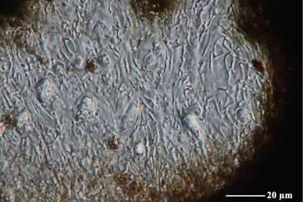
Source: https://fungi.myspecies.info/all-fungi/opegrapha-dolomitica - CC BY-NC
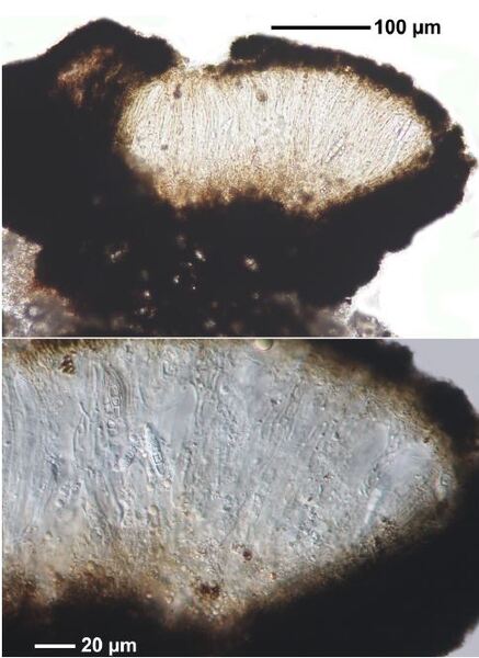
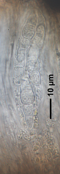
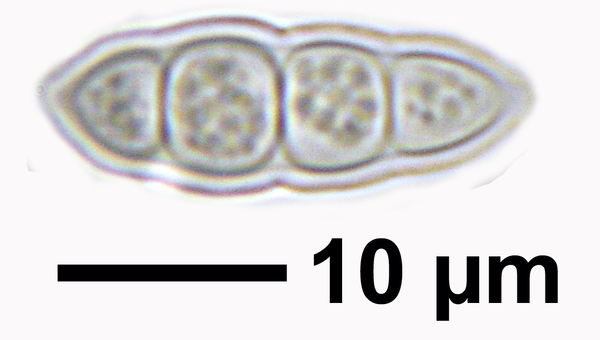
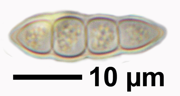
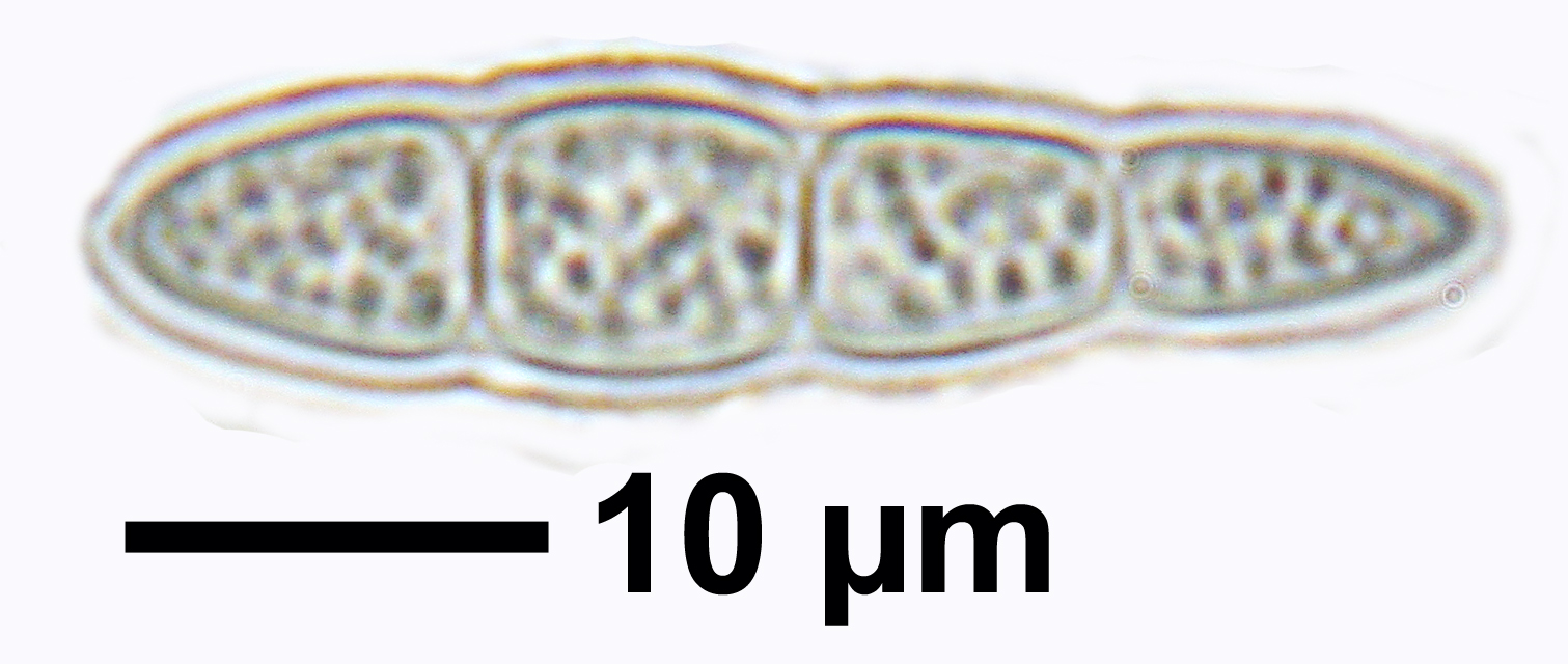
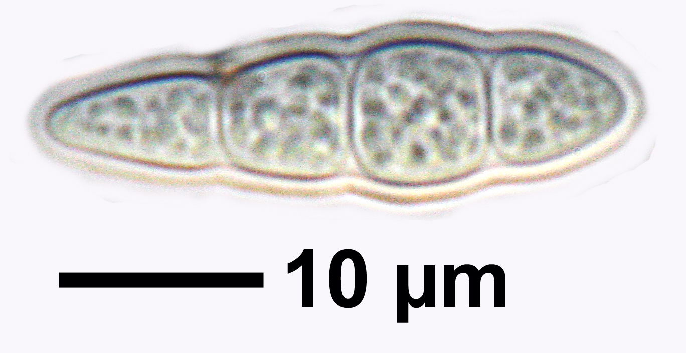
Opegrapha dolomitica, ascospores from specimen (Powell 3791) from Brierlow Dale, Derbyshire. The ascospores are predominantly 3-septate but occasionally an additional septum is present as seen here.
Source: https://fungi.myspecies.info/all-fungi/opegrapha-dolomitica - CC BY-NC
Opegrapha dolomitica, ascospores from specimen (Powell 3791) from Brierlow Dale, Derbyshire. The ascospores are predominantly 3-septate but occasionally an additional septum is present as seen here.
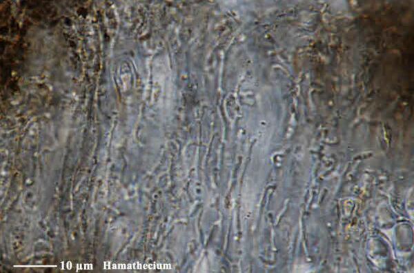
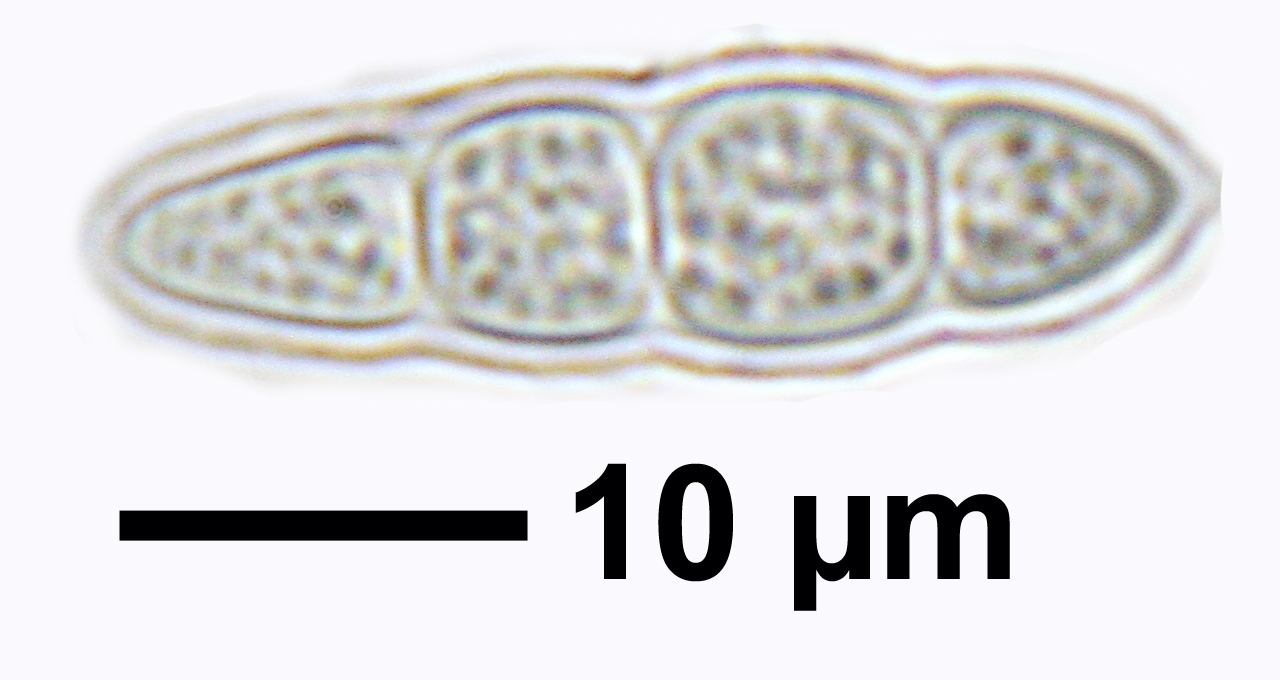
Source: https://fungi.myspecies.info/all-fungi/opegrapha-dolomitica - CC BY-NC
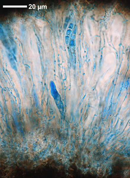
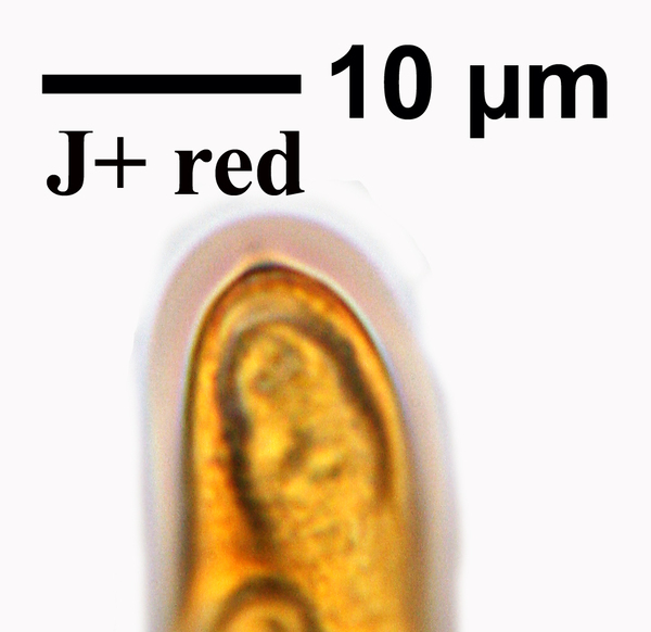
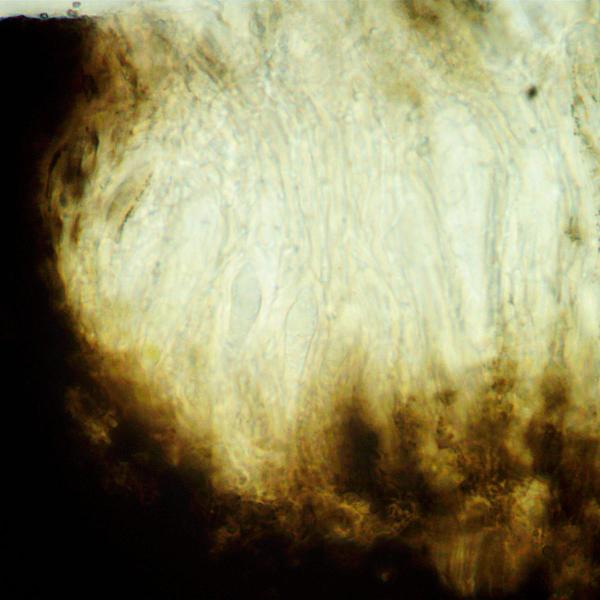
Opegrapha dolomitica, section of lirella mounted in K, showing lack of pigment reaction with this reagent.
Wolfgang von Brackel - CC BY-4.0
Germany, Bavaria, Kipfenberg
Growth form: Crustose
Substrata: rocks
Photobiont: Trentepohlia
Reproductive strategy: mainly sexual
In underhangs rarely wetted by rain
Commonnes-rarity: (info)
Alpine belt: absent
Subalpine belt: absent
Oromediterranean belt: absent
Montane belt: rare
Submediterranean belt: very rare
Padanian area: absent
Humid submediterranean belt: very rare
Humid mediterranean belt: extremely rare
Dry mediterranean belt: absent
Predictive model
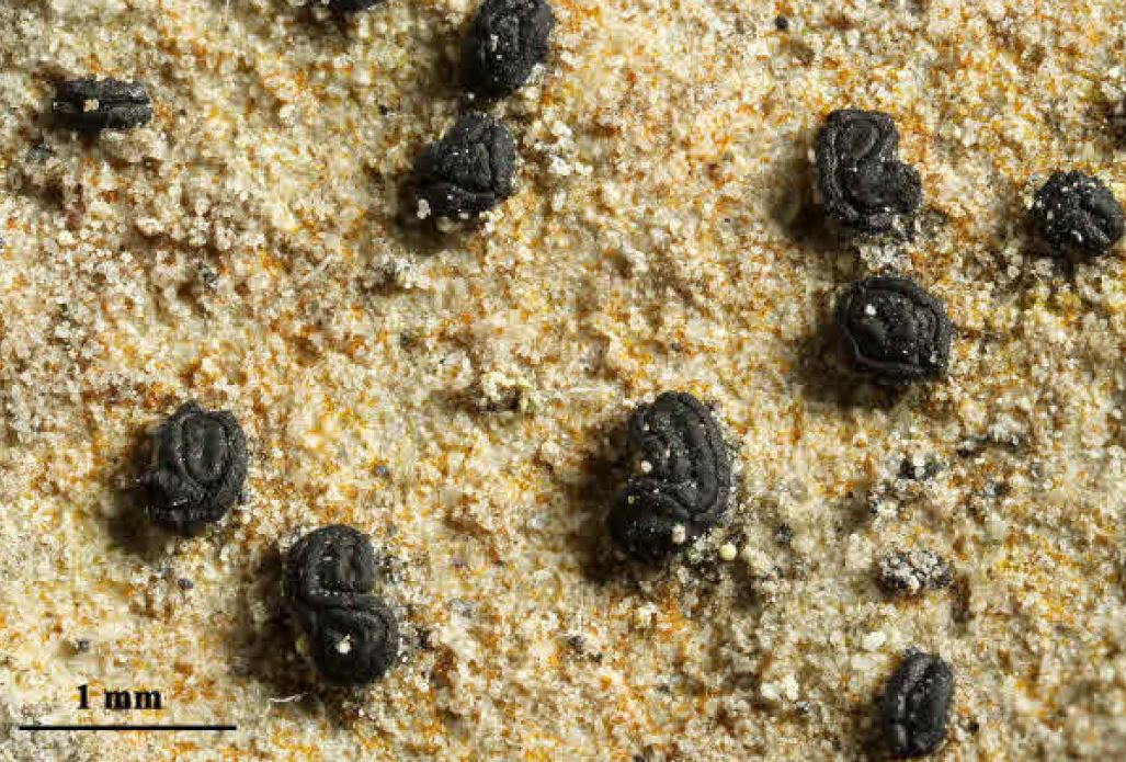
| Herbarium samples |
 DOLICHENS
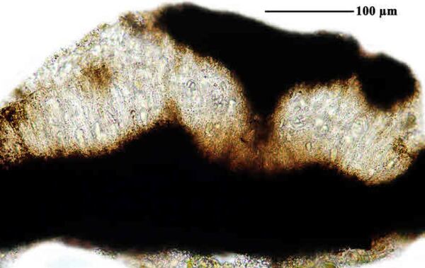
Courtesy Danièle et Olivier Gonnet - Source: https://www.afl-lichenologie.fr/Photos_AFL/Photos_AFL_O/Texte_O/Opegrapha_dolomitica.htm
France

Domenico Puntillo; Owner: Domenico Puntillo
Italy
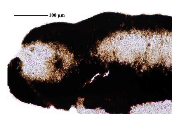
Felix Schumm – CC BY-SA 4.0
[16685], Germany, Baden-Württemberg, Schwäbische Alb, Kreis Heidenheim, Steinheim a. Albuch, Wental, schattige, feuchte Kalkfelsen im Wald nahe dem Gnannenstein, 48.70783° N, 10.03095° E, 580 m. Leg. et det. Schumm 19.09.2010.

Felix Schumm – CC BY-SA 4.0
[16685], Germany, Baden-Württemberg, Schwäbische Alb, Kreis Heidenheim, Steinheim a. Albuch, Wental, schattige, feuchte Kalkfelsen im Wald nahe dem Gnannenstein, 48.70783° N, 10.03095° E, 580 m. Leg. et det. Schumm 19.09.2010.

Felix Schumm – CC BY-SA 4.0
[16685], Germany, Baden-Württemberg, Schwäbische Alb, Kreis Heidenheim, Steinheim a. Albuch, Wental, schattige, feuchte Kalkfelsen im Wald nahe dem Gnannenstein, 48.70783° N, 10.03095° E, 580 m. Leg. et det. Schumm 19.09.2010.
Domenico Puntillo; Owner: Domenico Puntillo
Italy
Felix Schumm – CC BY-SA 4.0
[19296], Germany, Bayern, Ammergauer Alpen, Wank, 47.50645° N, 11.14142° E, 1640 m, auf Kalkstein. Leg. F. Schumm, U. Schwarz & M. Guwak, Aug. 2014. Det F. Schumm 2014
Unusual form

Felix Schumm – CC BY-SA 4.0
[19296], Germany, Bayern, Ammergauer Alpen, Wank, 47.50645° N, 11.14142° E, 1640 m, auf Kalkstein. Leg. F. Schumm, U. Schwarz & M. Guwak, Aug. 2014. Det F. Schumm 2014
Unusual form

Felix Schumm – CC BY-SA 4.0
[19296], Germany, Bayern, Ammergauer Alpen, Wank, 47.50645° N, 11.14142° E, 1640 m, auf Kalkstein. Leg. F. Schumm, U. Schwarz & M. Guwak, Aug. 2014. Det F. Schumm 2014
Unusual form
Felix Schumm – CC BY-SA 4.0
[19296], Germany, Bayern, Ammergauer Alpen, Wank, 47.50645° N, 11.14142° E, 1640 m, auf Kalkstein. Leg. F. Schumm, U. Schwarz & M. Guwak, Aug. 2014. Det F. Schumm 2014
Unusual form
Felix Schumm – CC BY-SA 4.0
[19296], Germany, Bayern, Ammergauer Alpen, Wank, 47.50645° N, 11.14142° E, 1640 m, auf Kalkstein. Leg. F. Schumm, U. Schwarz & M. Guwak, Aug. 2014. Det F. Schumm 2014
Unusual form

Felix Schumm – CC BY-SA 4.0
[19296], Germany, Bayern, Ammergauer Alpen, Wank, 47.50645° N, 11.14142° E, 1640 m, auf Kalkstein. Leg. F. Schumm, U. Schwarz & M. Guwak, Aug. 2014. Det F. Schumm 2014
Unusual form

Felix Schumm – CC BY-SA 4.0
[19296], Germany, Bayern, Ammergauer Alpen, Wank, 47.50645° N, 11.14142° E, 1640 m, auf Kalkstein. Leg. F. Schumm, U. Schwarz & M. Guwak, Aug. 2014. Det F. Schumm 2014
Unusual form
Felix Schumm – CC BY-SA 4.0
[19296], Germany, Bayern, Ammergauer Alpen, Wank, 47.50645° N, 11.14142° E, 1640 m, auf Kalkstein. Leg. F. Schumm, U. Schwarz & M. Guwak, Aug. 2014. Det F. Schumm 2014
Unusual form
Felix Schumm – CC BY-SA 4.0
[19296], Germany, Bayern, Ammergauer Alpen, Wank, 47.50645° N, 11.14142° E, 1640 m, auf Kalkstein. Leg. F. Schumm, U. Schwarz & M. Guwak, Aug. 2014. Det F. Schumm 2014
Unusual form

Felix Schumm CC BY-SA 4.0
[16685], Germany, Baden-Württemberg, Schwäbische Alb, Kreis Heidenheim, Steinheim a. Albuch, Wental, schattige, feuchte Kalkfelsen im Wald nahe dem Gnannenstein, 48.70783° N, 10.03095° E, 580 m. Leg. et det. Schumm 19.09.2010.

Felix Schumm CC BY-SA 4.0
[16685], Germany, Baden-Württemberg, Schwäbische Alb, Kreis Heidenheim, Steinheim a. Albuch, Wental, schattige, feuchte Kalkfelsen im Wald nahe dem Gnannenstein, 48.70783° N, 10.03095° E, 580 m. Leg. et det. Schumm 19.09.2010.

Felix Schumm CC BY-SA 4.0
[16685], Germany, Baden-Württemberg, Schwäbische Alb, Kreis Heidenheim, Steinheim a. Albuch, Wental, schattige, feuchte Kalkfelsen im Wald nahe dem Gnannenstein, 48.70783° N, 10.03095° E, 580 m. Leg. et det. Schumm 19.09.2010.

Felix Schumm CC BY-SA 4.0
[16685], Germany, Baden-Württemberg, Schwäbische Alb, Kreis Heidenheim, Steinheim a. Albuch, Wental, schattige, feuchte Kalkfelsen im Wald nahe dem Gnannenstein, 48.70783° N, 10.03095° E, 580 m. Leg. et det. Schumm 19.09.2010.

Felix Schumm CC BY-SA 4.0
[16685], Germany, Baden-Württemberg, Schwäbische Alb, Kreis Heidenheim, Steinheim a. Albuch, Wental, schattige, feuchte Kalkfelsen im Wald nahe dem Gnannenstein, 48.70783° N, 10.03095° E, 580 m. Leg. et det. Schumm 19.09.2010.

Felix Schumm CC BY-SA 4.0
[16685], Germany, Baden-Württemberg, Schwäbische Alb, Kreis Heidenheim, Steinheim a. Albuch, Wental, schattige, feuchte Kalkfelsen im Wald nahe dem Gnannenstein, 48.70783° N, 10.03095° E, 580 m. Leg. et det. Schumm 19.09.2010.
Felix Schumm CC BY-SA 4.0
[16685], Germany, Baden-Württemberg, Schwäbische Alb, Kreis Heidenheim, Steinheim a. Albuch, Wental, schattige, feuchte Kalkfelsen im Wald nahe dem Gnannenstein, 48.70783° N, 10.03095° E, 580 m. Leg. et det. Schumm 19.09.2010.

Felix Schumm CC BY-SA 4.0
[16685], Germany, Baden-Württemberg, Schwäbische Alb, Kreis Heidenheim, Steinheim a. Albuch, Wental, schattige, feuchte Kalkfelsen im Wald nahe dem Gnannenstein, 48.70783° N, 10.03095° E, 580 m. Leg. et det. Schumm 19.09.2010.
Felix Schumm CC BY-SA 4.0
[16685], Germany, Baden-Württemberg, Schwäbische Alb, Kreis Heidenheim, Steinheim a. Albuch, Wental, schattige, feuchte Kalkfelsen im Wald nahe dem Gnannenstein, 48.70783° N, 10.03095° E, 580 m. Leg. et det. Schumm 19.09.2010.
Felix Schumm CC BY-SA 4.0
[16685], Germany, Baden-Württemberg, Schwäbische Alb, Kreis Heidenheim, Steinheim a. Albuch, Wental, schattige, feuchte Kalkfelsen im Wald nahe dem Gnannenstein, 48.70783° N, 10.03095° E, 580 m. Leg. et det. Schumm 19.09.2010.
Felix Schumm CC BY-SA 4.0
[16685], Germany, Baden-Württemberg, Schwäbische Alb, Kreis Heidenheim, Steinheim a. Albuch, Wental, schattige, feuchte Kalkfelsen im Wald nahe dem Gnannenstein, 48.70783° N, 10.03095° E, 580 m. Leg. et det. Schumm 19.09.2010.
Felix Schumm CC BY-SA 4.0
[16685], Germany, Baden-Württemberg, Schwäbische Alb, Kreis Heidenheim, Steinheim a. Albuch, Wental, schattige, feuchte Kalkfelsen im Wald nahe dem Gnannenstein, 48.70783° N, 10.03095° E, 580 m. Leg. et det. Schumm 19.09.2010.
Felix Schumm CC BY-SA 4.0
[16685], Germany, Baden-Württemberg, Schwäbische Alb, Kreis Heidenheim, Steinheim a. Albuch, Wental, schattige, feuchte Kalkfelsen im Wald nahe dem Gnannenstein, 48.70783° N, 10.03095° E, 580 m. Leg. et det. Schumm 19.09.2010.
Felix Schumm – CC BY-SA 4.0
[19296], Germany, Bayern, Ammergauer Alpen, Wank, 47.50645° N, 11.14142° E, 1640 m, auf Kalkstein. Leg. F. Schumm, U. Schwarz & M. Guwak, Aug. 2014. Det F. Schumm 2014
Unusual form

Courtesy Danièle et Olivier Gonnet - Source: https://www.afl-lichenologie.fr/Photos_AFL/Photos_AFL_O/Texte_O/Opegrapha_dolomitica.htm
France

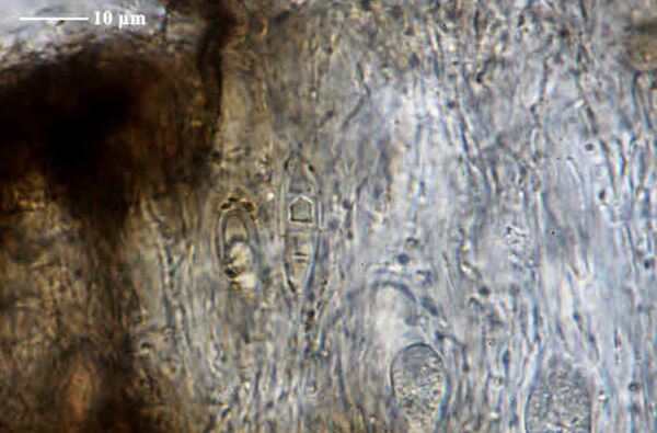
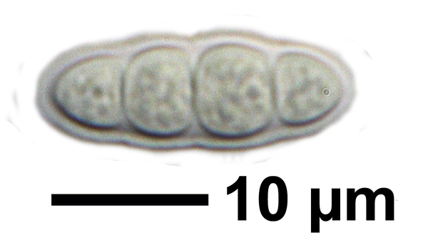
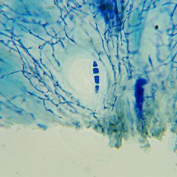
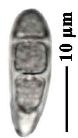
Source: https://fungi.myspecies.info/all-fungi/opegrapha-dolomitica - CC BY-NC
Opegrapha dolomitica, ascospores from specimen (Powell 3791) from Brierlow Dale, Derbyshire. The ascospores are predominantly 3-septate but occasionally an additional septum is present as seen here.

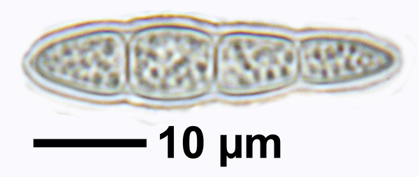
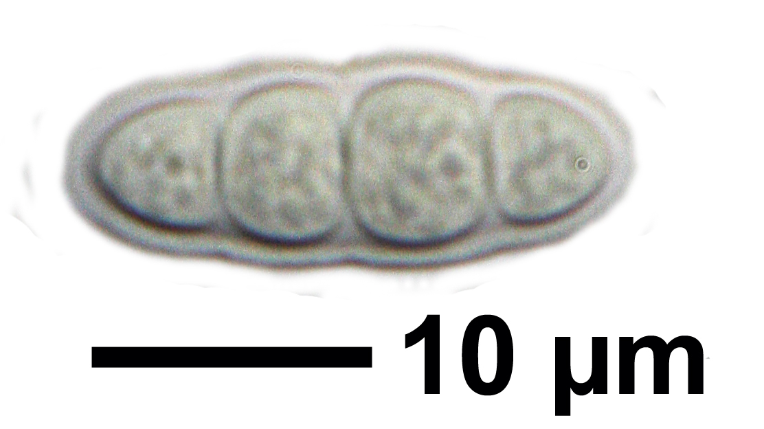
Source: https://fungi.myspecies.info/all-fungi/opegrapha-dolomitica - CC BY-NC
Opegrapha dolomitica, ascospores from specimen (Powell 3791) from Brierlow Dale, Derbyshire. The ascospores are predominantly 3-septate but occasionally an additional septum is present as seen here.

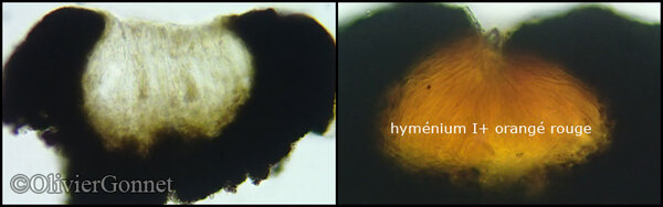
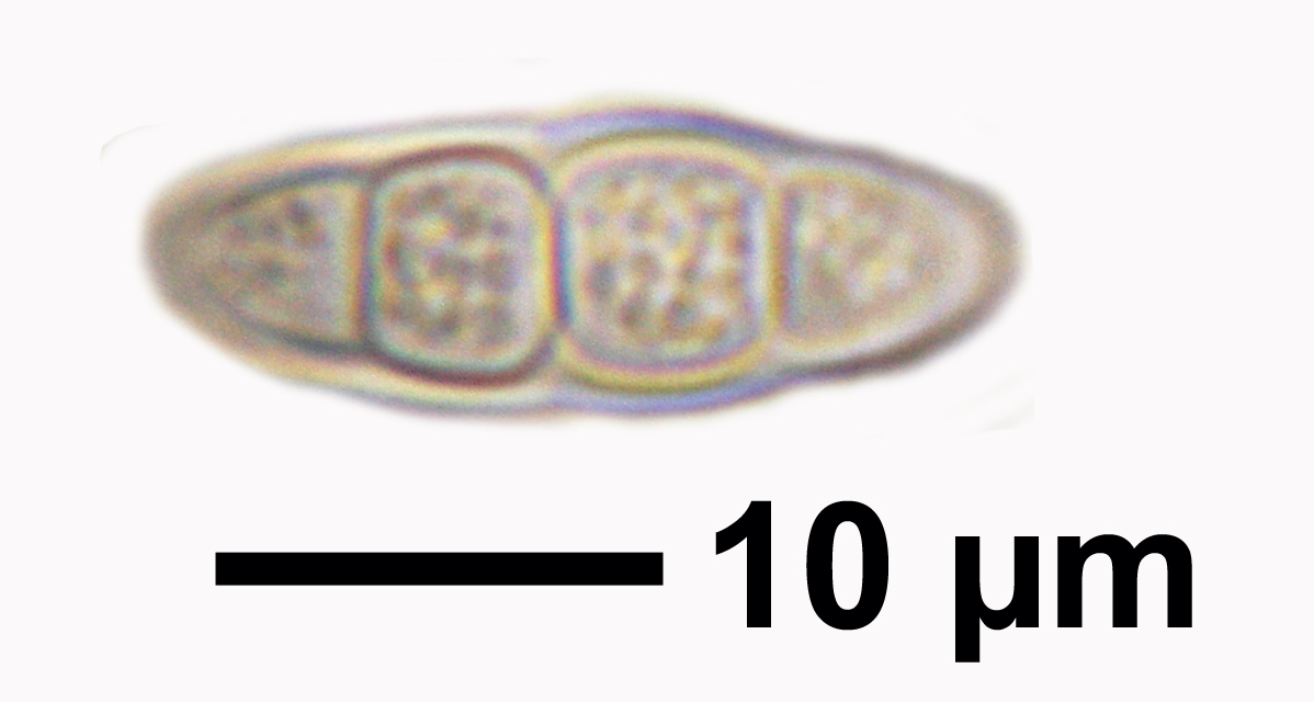
Source: https://fungi.myspecies.info/all-fungi/opegrapha-dolomitica - CC BY-NC
Opegrapha dolomitica, section of lirella mounted in K, showing lack of pigment reaction with this reagent.