Trapelia coarctata (Sm.) M. Choisy
in Werner, Bull. Soc. Sc. Nat. Maroc, 12: 160, 1932. Basionym: Lichen coarctatus Turner ex Sm. in Smith & Sowerby - Engl. Bot.: 8, tab. 534, 1799.
Synonyms: Biatora arridens (Nyl.) Walt. Watson; Biatora coarctata (Sm.) Th. Fr.; Biatora coarctata subsp. terrula Hulting; Lecanactis arridens Nyl.; Lecanora coarctata (Sm.) Ach.; Lecanora coarctata var. argilliseda Dufour ex Schaer.; Lecanora ocrinaeta Ach.; Lecidea arridens Nyl.; Lecidea coarctata (Sm.) Nyl.; Lecidea cotaria Ach.; Zeora coarctata (Sm.) Flot.
Distribution: N - VG (Castello 2002, Martellos & Castello 2004, Tretiach & al. 2007b), Frl (Tretiach & Hafellner 2000), Ven, TAA (Obermayer 2004, Thor & Nascimbene 2007, Nascimbene & al. 2022), Lomb (Gheza & al. 2015), Piem (Isocrono & al. 2004, Favero-Longo & al. 2006b), VA (Piervittori & Isocrono 1999, Valcuvia 2000), Emil (Tretiach & al. 2008, Fariselli & al. 2020), Lig (Brunialti & al. 1999). C - Tosc (Tretiach & Nimis 1994, Benesperi 2011, Brackel 2015), Umb (Genovesi & al. 2001, Ravera & al. 2006, Genovesi 2011), Laz (Bartoli 1997b), Abr (Ravera & al. 2025b), Mol (Nimis & Tretiach 2004, Caporale & al. 2008), Sar. S - Camp (Nimis & Tretiach 2004), Pugl, Bas (Nimis & Tretiach 1999), Cal (Puntillo 1996, Puntillo & Puntillo 2004, Potenza & al. 2011), Si (Nimis & al. 1996b).
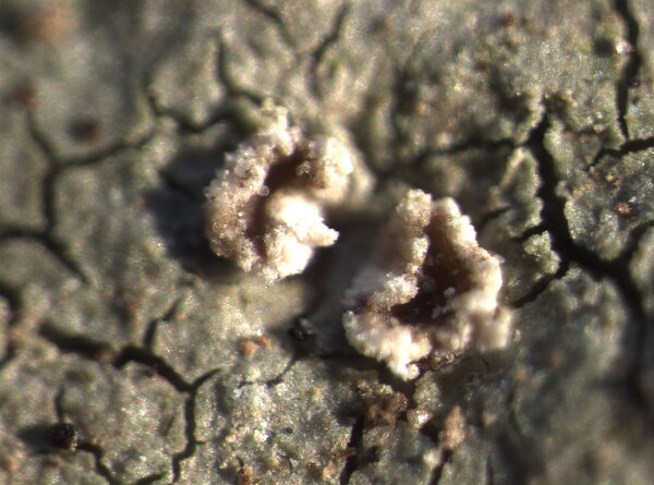
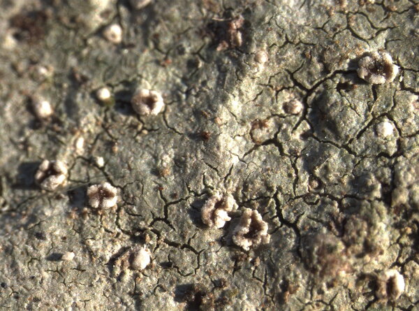
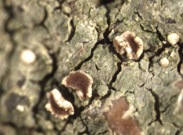
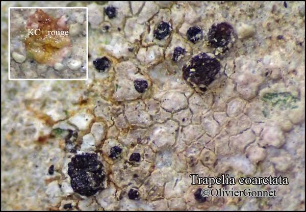
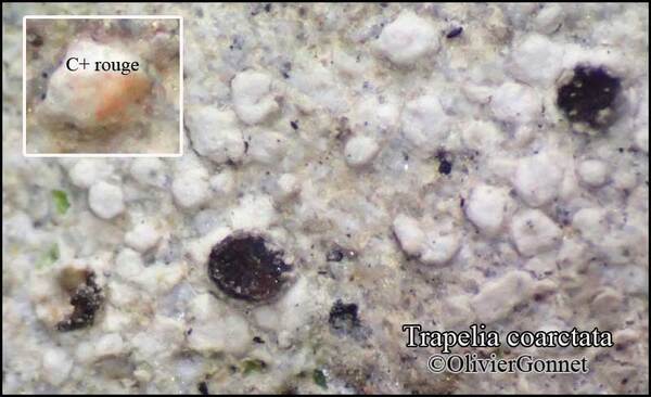
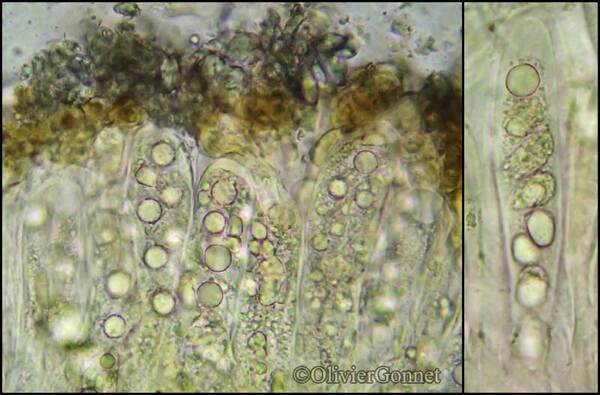
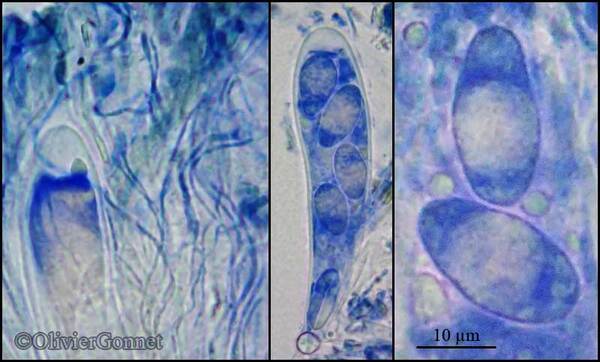
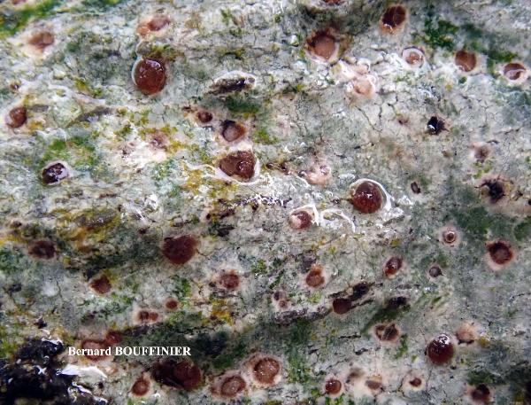
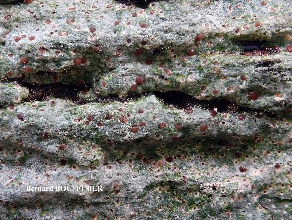
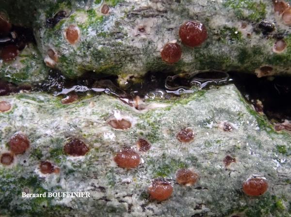
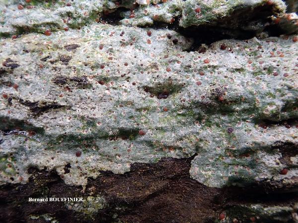
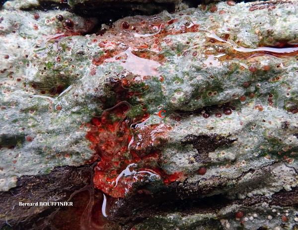
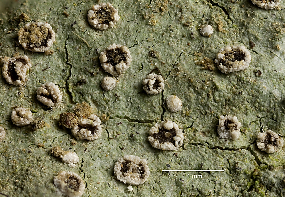
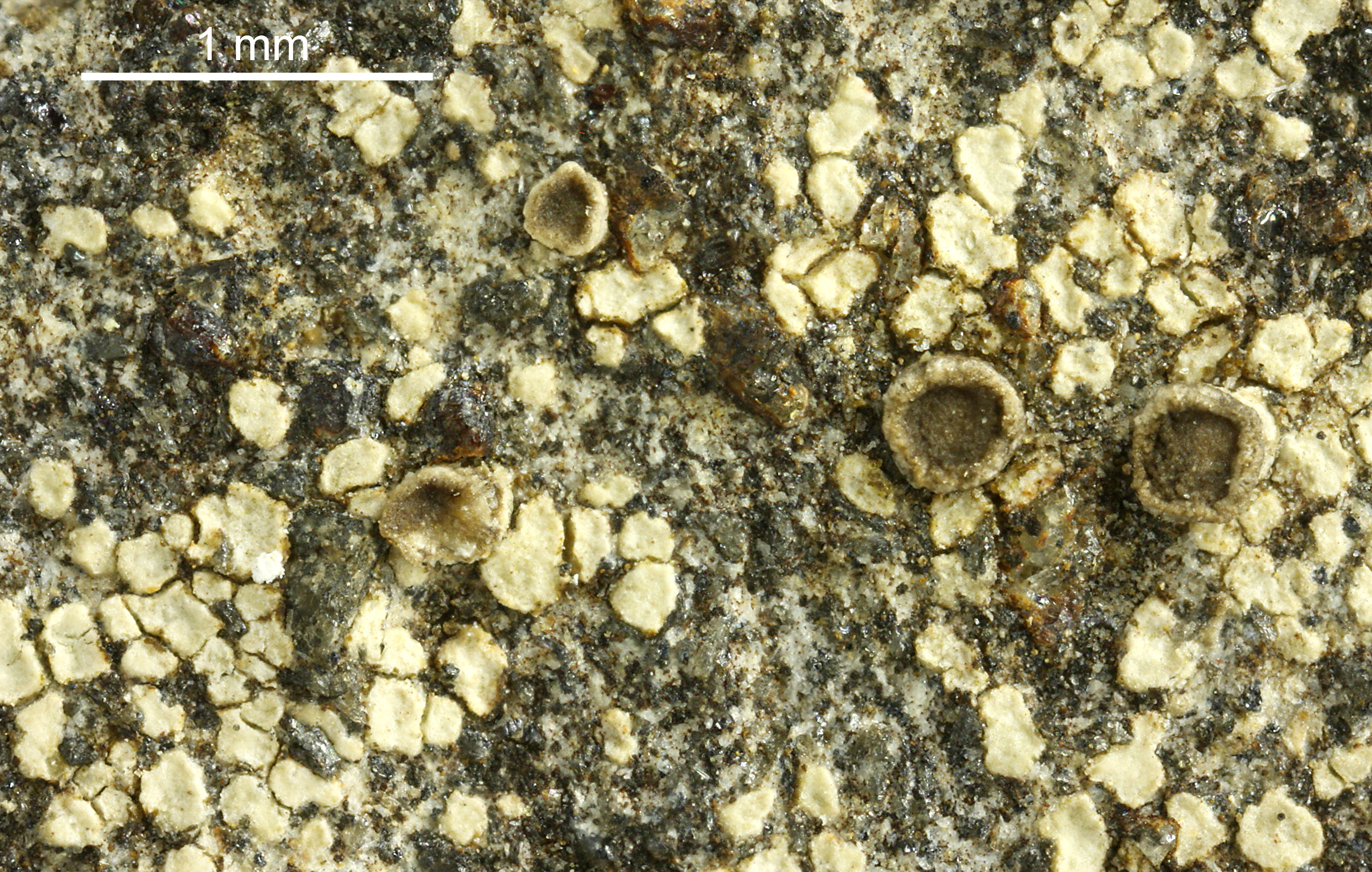
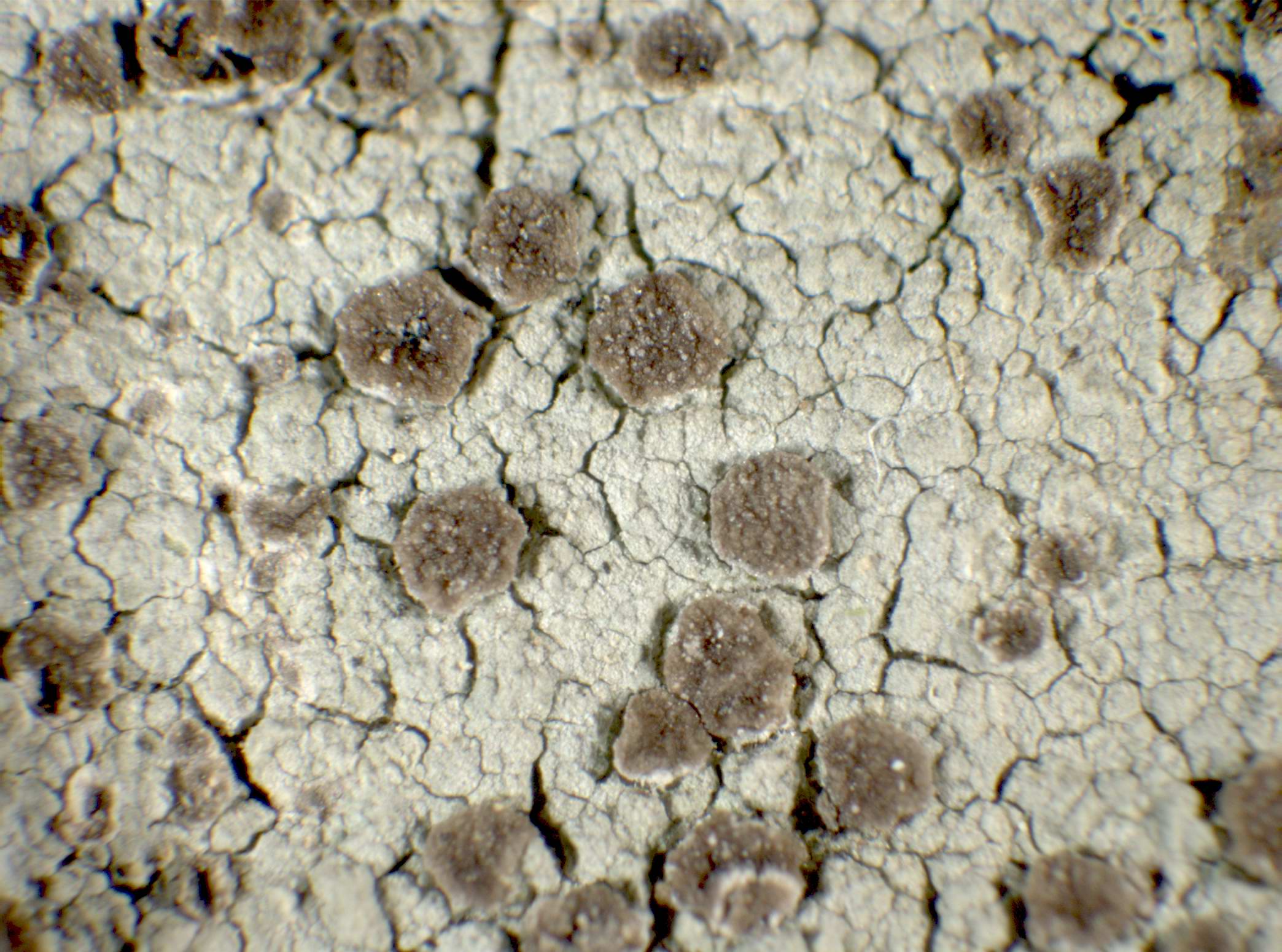
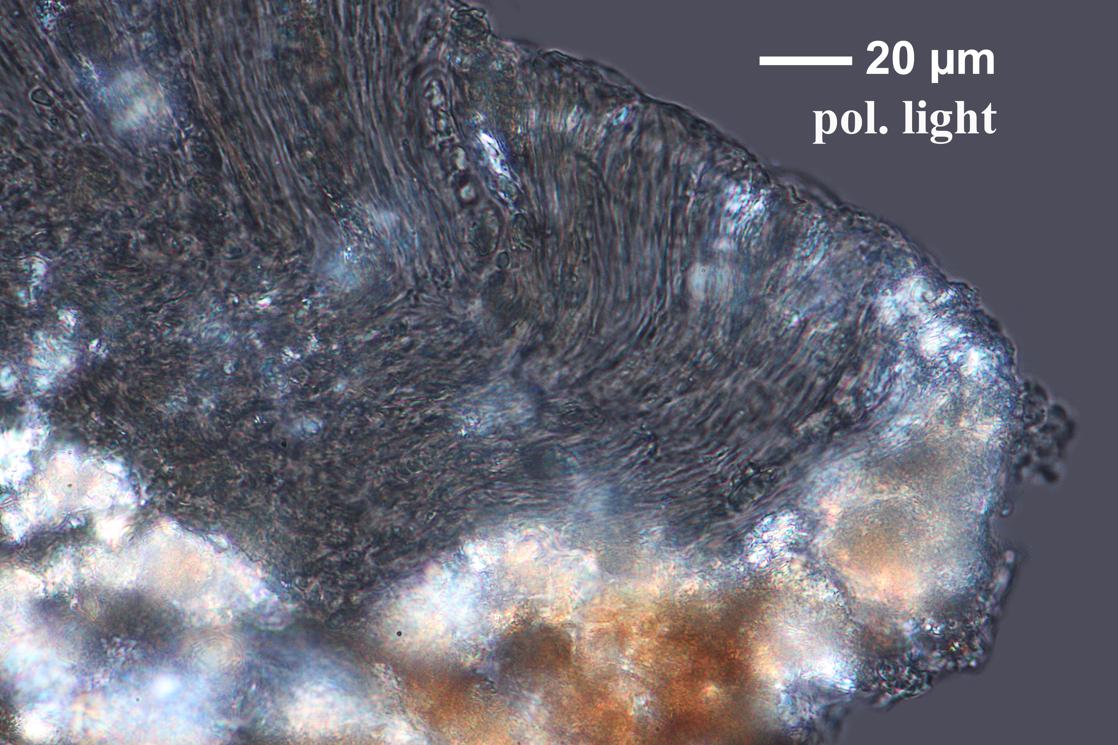
Description: Thallus crustose, episubstratic, pale greenish grey, up to 160 µm thick, continuous to rimose, rarely areolate, sometimes with a thin whitish prothallus, the margin with small, gently convex, poorly delimited areole-like units which sometimes appear separate on the prothallus, but mostly coalesce from the start. Apothecia frequent, round at least when young, sessile, up 0.3-0.6(-0.8) mm across, with a dark reddish-brown to finally black, flat to slightly convex, rough disc and a concolorous, finally often excluded proper margin surrounded by a thin, whitish pseudothalline margin in young apothecia; immature apothecia frequent, appearing as white dots on the thallus. Proper exciple of colourless hyphae embedded in a colourless to weakly pigmented gel; epithecium almost colourless to pale yellowish brown; hymenium colourless, 90-140 µm high; paraphyses coherent, thin, densely branched and anastomosing, not thickened at apex; hypothecium colourless to yellowish. Asci 8-spored, cylindrical-clavate, unitunicate, thin-walled, the apical dome K/I-, or weakly K/I+ blue, Trapelia-type. Ascospores 1-celled, hyaline, ellipsoid, 14.21 x 7-10 µm, without a perispore. Photobiont chlorococcoid. Spot tests: thallus K-, C+ red, KC+ red, P-, UV+ bluish white. Chemistry: thallus with gyrophoric acid (major), 5-O-methylhiascic acid (trace).Note: a holarctic early coloniser of siliceous pebbles near the soil surface, sometimes also found on bare clayey soil, with a wide altitudinal and latitudinal range; it is most frequent in upland areas, becoming rare, and mostly Tyrrhenian, in the eu-Mediterranean belt. The species is hardly distinguishable from T. elachista without molecular analysis, and all of the Italian records should be checked against that species.
Growth form: Crustose
Substrata: rocks, soil, terricolous mosses, and plant debris
Photobiont: green algae other than Trentepohlia
Reproductive strategy: mainly sexual
Pioneer species
Commonnes-rarity: (info)
Alpine belt: rather common
Subalpine belt: common
Oromediterranean belt: rare
Montane belt: rather rare
Submediterranean belt: rare
Padanian area: extremely rare
Humid submediterranean belt: rather common
Humid mediterranean belt: rare
Dry mediterranean belt: extremely rare
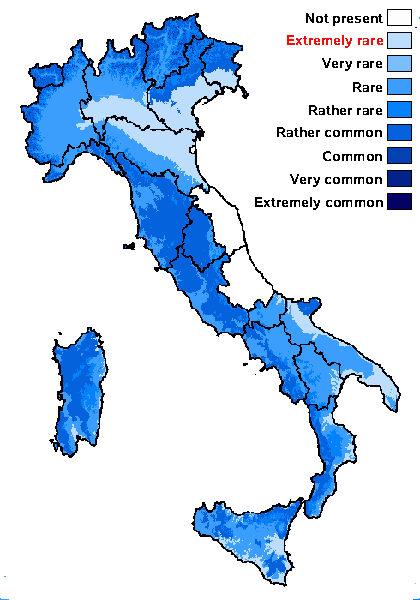
Predictive model
Herbarium samples
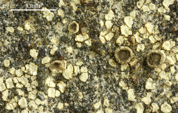

Felix Schumm – CC BY-SA 4.0
[11287], Portugal, Madeira, zwischen Rabaçal und Boca da Encumeada am Ostrand von Paúl da Serra nahe Bica da Cana, licht-, windoffen, tundrenartig, Felsbrocken am Boden. 32°44.225' N, 17°03.653' W, 1530 m. Leg. et det. Schumm 26.12.2003
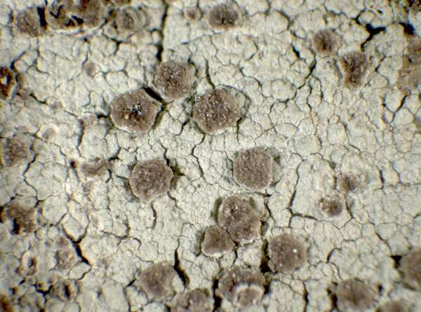
P.L. Nimis; Owner: Department of Life Sciences, University of Trieste
Herbarium: TSB (21632)
2001/12/05
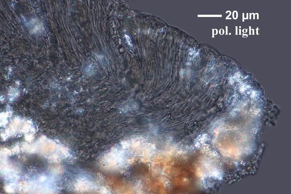
Felix Schumm – CC BY-SA 4.0
[11287], Portugal, Madeira, zwischen Rabaçal und Boca da Encumeada am Ostrand von Paúl da Serra nahe Bica da Cana, licht-, windoffen, tundrenartig, Felsbrocken am Boden. 32°44.225' N, 17°03.653' W, 1530 m. Leg. et det. Schumm 26.12.2003
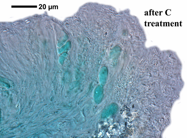
Felix Schumm – CC BY-SA 4.0
[11287], Portugal, Madeira, zwischen Rabaçal und Boca da Encumeada am Ostrand von Paúl da Serra nahe Bica da Cana, licht-, windoffen, tundrenartig, Felsbrocken am Boden. 32°44.225' N, 17°03.653' W, 1530 m. Leg. et det. Schumm 26.12.2003
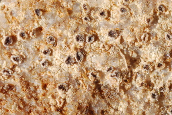
Domenico Puntillo; Owner: Domenico Puntillo
Italy
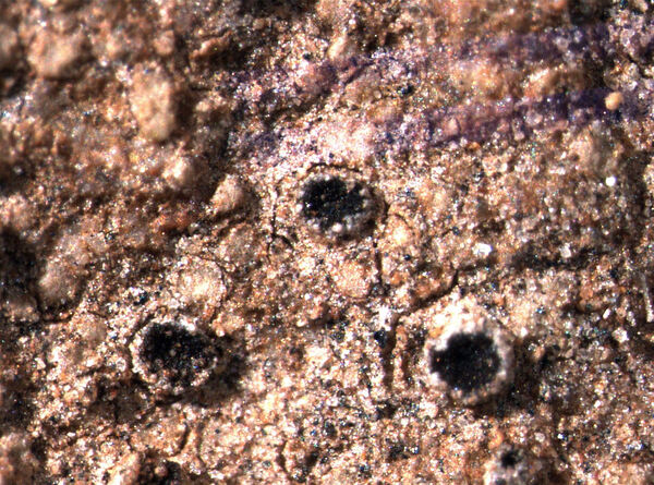
Pier Luigi Nimis - CC BY-SA 4.0
TSB 41855
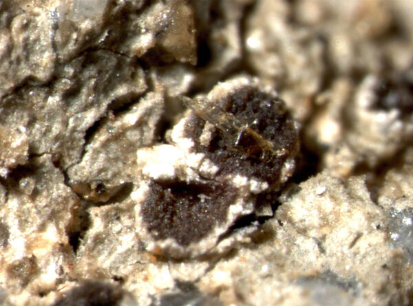
Pier Luigi Nimis - CC BY-SA 4.0
TSB 6799
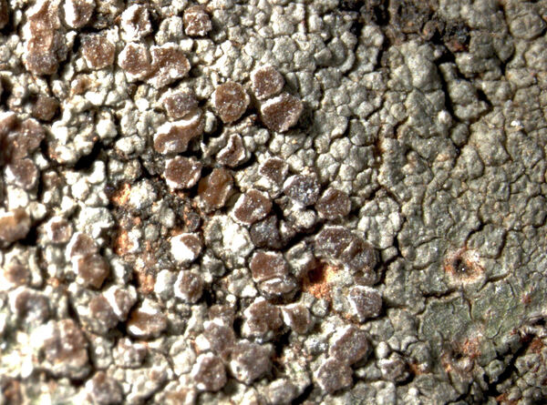
Pier Luigi Nimis - CC BY-SA 4.0
TSB 8346
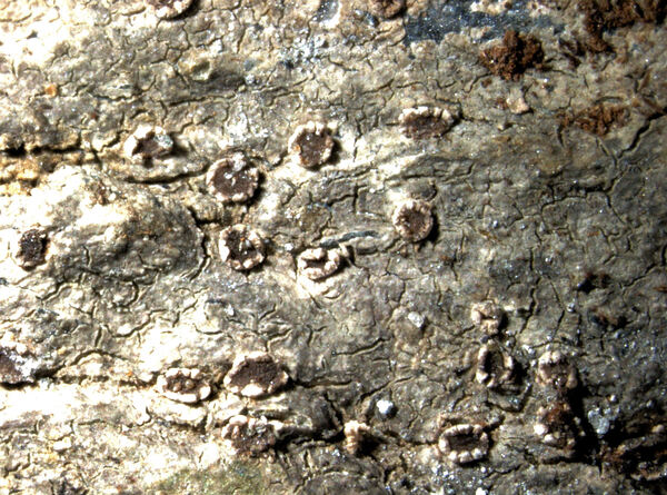
Pier Luigi Nimis - CC BY-SA 4.0
TSB 12261
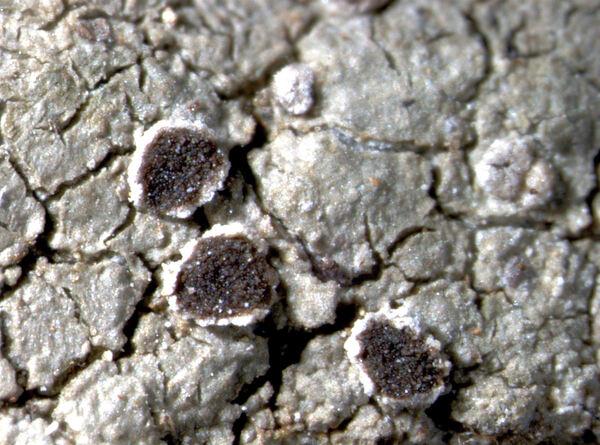
Pier Luigi Nimis - CC BY-SA 4.0
TSB 17649
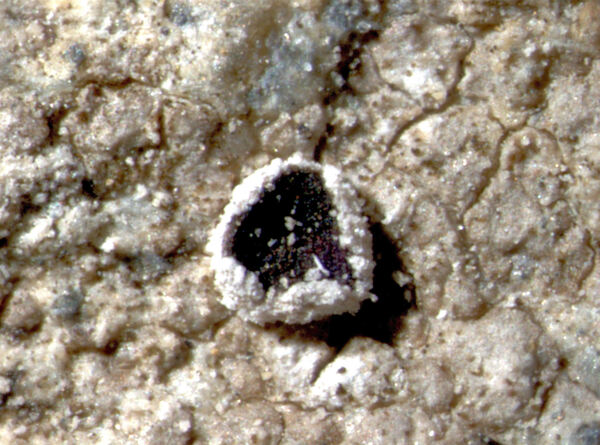
Pier Luigi Nimis - CC BY-SA 4.0
TSB 34140
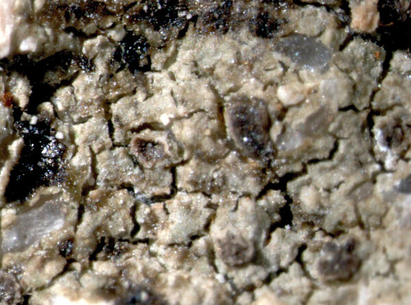
Pier Luigi Nimis - CC BY-SA 4.0
TSB 38141
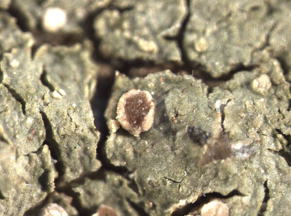
P.L. Nimis CC BY-SA 04
TSB 43706
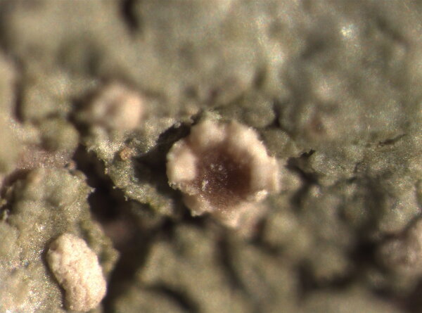
P.L. Nimis CC BY-SA 04
TSB 43706
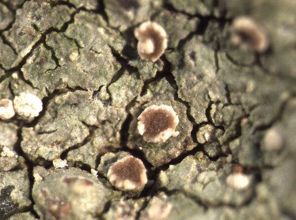
P.L. Nimis CC BY-SA 04
TSB 43706
P.L. Nimis CC BY-SA 04
TSB 43706
P.L. Nimis CC BY-SA 04
TSB 43706
P.L. Nimis CC BY-SA 04
TSB 43706
Courtesy Danièle et Olivier Gonnet - Source: https://www.afl-lichenologie.fr/Photos_AFL/Photos_AFL_T/Textes_T2/Trapelia_coarctata.htm
France, 1/6/2015 - session AFL Barcelonnette - Alpes-de-Haute-Provence
Courtesy Danièle et Olivier Gonnet - Source: https://www.afl-lichenologie.fr/Photos_AFL/Photos_AFL_T/Textes_T2/Trapelia_coarctata.htm
France, 1/6/2015 - session AFL Barcelonnette - Alpes-de-Haute-Provence
Courtesy Danièle et Olivier Gonnet - Source: https://www.afl-lichenologie.fr/Photos_AFL/Photos_AFL_T/Textes_T2/Trapelia_coarctata.htm
France, 1/6/2015 - session AFL Barcelonnette - Alpes-de-Haute-Provence
Courtesy Danièle et Olivier Gonnet - Source: https://www.afl-lichenologie.fr/Photos_AFL/Photos_AFL_T/Textes_T2/Trapelia_coarctata.htm
France, 1/6/2015 - session AFL Barcelonnette - Alpes-de-Haute-Provence
Bernard Bouffinier - Source: http://www.lichensmaritimes.org/index.php?task=fiche&lichen=605&lang=en
France, Châteaulin
Bernard Bouffinier - Source: http://www.lichensmaritimes.org/index.php?task=fiche&lichen=605&lang=en
France, Châteaulin
Bernard Bouffinier - Source: http://www.lichensmaritimes.org/index.php?task=fiche&lichen=605&lang=en
France, Châteaulin
Bernard Bouffinier - Source: http://www.lichensmaritimes.org/index.php?task=fiche&lichen=605&lang=en
France, Châteaulin
Bernard Bouffinier - Source: http://www.lichensmaritimes.org/index.php?task=fiche&lichen=605&lang=en
France, Châteaulin
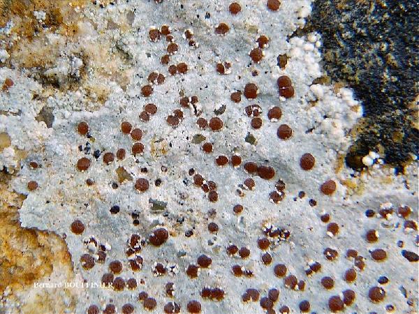
Bernard Bouffinier - Source: http://www.lichensmaritimes.org/index.php?task=fiche&lichen=605&lang=en
France, Scaër
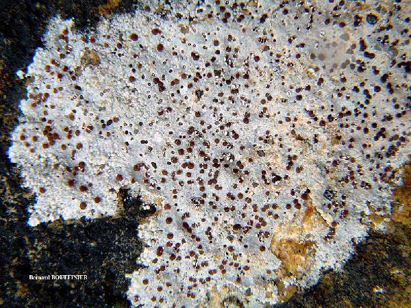
Bernard Bouffinier - Source: http://www.lichensmaritimes.org/index.php?task=fiche&lichen=605&lang=en
France, Scaër
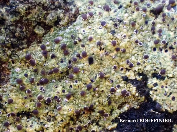
Bernard Bouffinier - Source: http://www.lichensmaritimes.org/index.php?task=fiche&lichen=605&lang=en
France, Roscanvel
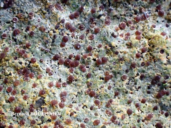
Bernard Bouffinier - Source: http://www.lichensmaritimes.org/index.php?task=fiche&lichen=605&lang=en
France, Roscanvel
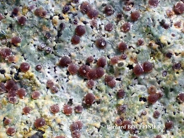
Bernard Bouffinier - Source: http://www.lichensmaritimes.org/index.php?task=fiche&lichen=605&lang=en
France, Roscanvel
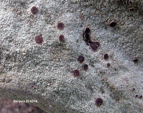
Jacques Haine - Source: http://www.lichensmaritimes.org/index.php?task=fiche&lichen=605&lang=en
France, Ardennes
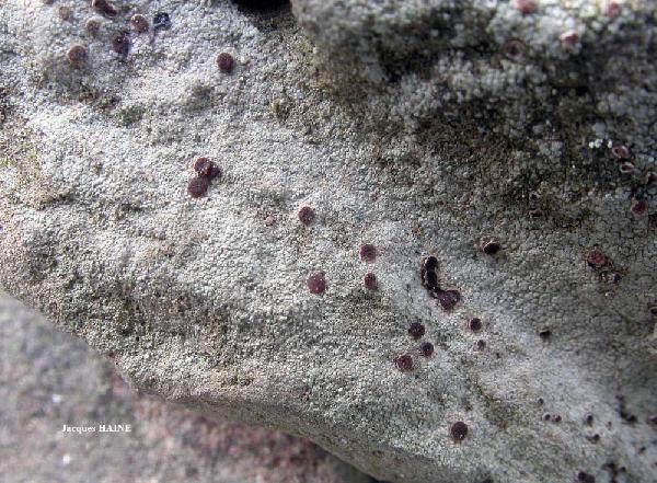
Jacques Haine - Source: http://www.lichensmaritimes.org/index.php?task=fiche&lichen=605&lang=en
France, Ardennes
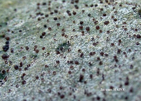
Jacques Haine - Source: http://www.lichensmaritimes.org/index.php?task=fiche&lichen=605&lang=en
France, Ardennes
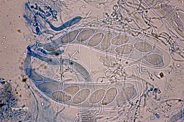
Jacques Haine - Source: http://www.lichensmaritimes.org/index.php?task=fiche&lichen=605&lang=en
France, Ardennes
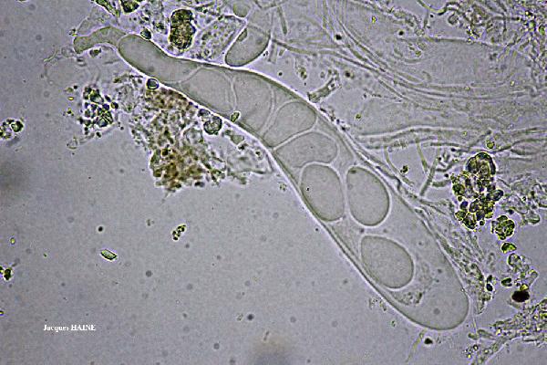
Jacques Haine - Source: http://www.lichensmaritimes.org/index.php?task=fiche&lichen=605&lang=en
France, Ardennes
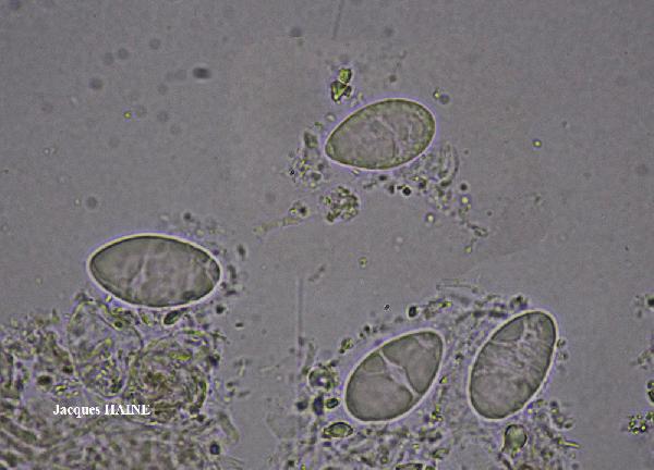
Jacques Haine - Source: http://www.lichensmaritimes.org/index.php?task=fiche&lichen=605&lang=en
France, Ardennes
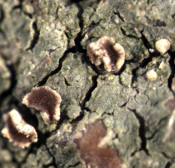
P.L. Nimis CC BY-SA 04
TSB 43706

Wolfgang von Brackel - CC BY-4.0
Germany, Bavaria, Grafenwöhr

Felix Schumm - CC BY 4.0
[11244], Portugal, Azoren, Sao Miguel: SO von Ribeira Grande oberhalb
von Lombadas, auf offenem Boden, licht-, nebel- und windoffen.
37°47.173' N, 25°27.894' W, 680 m. Leg. F. Schumm. 07.06.2003. det.
F.Schumm 12.2003.

Felix Schumm - CC BY 4.0
[11244], Portugal, Azoren, Sao Miguel: SO von Ribeira Grande oberhalb
von Lombadas, auf offenem Boden, licht-, nebel- und windoffen.
37°47.173' N, 25°27.894' W, 680 m. Leg. F. Schumm. 07.06.2003. det.
F.Schumm 12.2003.

Felix Schumm - CC BY 4.0
[11244], Portugal, Azoren, Sao Miguel: SO von Ribeira Grande oberhalb
von Lombadas, auf offenem Boden, licht-, nebel- und windoffen.
37°47.173' N, 25°27.894' W, 680 m. Leg. F. Schumm. 07.06.2003. det.
F.Schumm 12.2003.

Felix Schumm - CC BY 4.0
[11244], Portugal, Azoren, Sao Miguel: SO von Ribeira Grande oberhalb
von Lombadas, auf offenem Boden, licht-, nebel- und windoffen.
37°47.173' N, 25°27.894' W, 680 m. Leg. F. Schumm. 07.06.2003. det.
F.Schumm 12.2003.

Felix Schumm - CC BY 4.0
[11244], Portugal, Azoren, Sao Miguel: SO von Ribeira Grande oberhalb
von Lombadas, auf offenem Boden, licht-, nebel- und windoffen.
37°47.173' N, 25°27.894' W, 680 m. Leg. F. Schumm. 07.06.2003. det.
F.Schumm 12.2003.

Felix Schumm - CC BY 4.0
[11244], Portugal, Azoren, Sao Miguel: SO von Ribeira Grande oberhalb
von Lombadas, auf offenem Boden, licht-, nebel- und windoffen.
37°47.173' N, 25°27.894' W, 680 m. Leg. F. Schumm. 07.06.2003. det.
F.Schumm 12.2003.

Felix Schumm - CC BY 4.0
[11244], Portugal, Azoren, Sao Miguel: SO von Ribeira Grande oberhalb
von Lombadas, auf offenem Boden, licht-, nebel- und windoffen.
37°47.173' N, 25°27.894' W, 680 m. Leg. F. Schumm. 07.06.2003. det.
F.Schumm 12.2003.

Felix Schumm - CC BY 4.0
[11244], Portugal, Azoren, Sao Miguel: SO von Ribeira Grande oberhalb
von Lombadas, auf offenem Boden, licht-, nebel- und windoffen.
37°47.173' N, 25°27.894' W, 680 m. Leg. F. Schumm. 07.06.2003. det.
F.Schumm 12.2003.

Felix Schumm - CC BY 4.0
[11287]. PORTUGAL, MADEIRA: Zwischen Rabaçal und Boca da
Encumeada am Ostrand von Paúl da Serra nahe Bica da Cana, licht-,
windoffen, tundrenartig, Felsbrocken am Boden, 32°44.225' N,
17°03.653' W, 1530 m. Leg. F. Schumm 26.12.2003, det. F. Schumm
2011, test et conf. Aptroot 2011.

Felix Schumm - CC BY 4.0
[11287]. PORTUGAL, MADEIRA: Zwischen Rabaçal und Boca da
Encumeada am Ostrand von Paúl da Serra nahe Bica da Cana, licht-,
windoffen, tundrenartig, Felsbrocken am Boden, 32°44.225' N,
17°03.653' W, 1530 m. Leg. F. Schumm 26.12.2003, det. F. Schumm
2011, test et conf. Aptroot 2011.

Felix Schumm - CC BY 4.0
[11287]. PORTUGAL, MADEIRA: Zwischen Rabaçal und Boca da
Encumeada am Ostrand von Paúl da Serra nahe Bica da Cana, licht-,
windoffen, tundrenartig, Felsbrocken am Boden, 32°44.225' N,
17°03.653' W, 1530 m. Leg. F. Schumm 26.12.2003, det. F. Schumm
2011, test et conf. Aptroot 2011.

Felix Schumm - CC BY 4.0
[17278], Germany, Baden-Württemberg, Schwarzwald-Baar-Kreis,
zwischen Villingen und Stockburg, ca. 3 km NW von Villingen,
48.071988° N, 8.419199° E, 740 m. An Granit. Leg. F. F.Schumm
03.06.2011, det. F.Schumm 2011, test. Aptroot 2011.

Felix Schumm - CC BY 4.0
[17278], Germany, Baden-Württemberg, Schwarzwald-Baar-Kreis,
zwischen Villingen und Stockburg, ca. 3 km NW von Villingen,
48.071988° N, 8.419199° E, 740 m. An Granit. Leg. F. F.Schumm
03.06.2011, det. F.Schumm 2011, test. Aptroot 2011.

Felix Schumm - CC BY 4.0
[17278], Germany, Baden-Württemberg, Schwarzwald-Baar-Kreis,
zwischen Villingen und Stockburg, ca. 3 km NW von Villingen,
48.071988° N, 8.419199° E, 740 m. An Granit. Leg. F. F.Schumm
03.06.2011, det. F.Schumm 2011, test. Aptroot 2011.

Felix Schumm - CC BY 4.0
[17278], Germany, Baden-Württemberg, Schwarzwald-Baar-Kreis,
zwischen Villingen und Stockburg, ca. 3 km NW von Villingen,
48.071988° N, 8.419199° E, 740 m. An Granit. Leg. F. F.Schumm
03.06.2011, det. F.Schumm 2011, test. Aptroot 2011.

Felix Schumm - CC BY 4.0
[17278], Germany, Baden-Württemberg, Schwarzwald-Baar-Kreis,
zwischen Villingen und Stockburg, ca. 3 km NW von Villingen,
48.071988° N, 8.419199° E, 740 m. An Granit. Leg. F. F.Schumm
03.06.2011, det. F.Schumm 2011, test. Aptroot 2011.

Felix Schumm - CC BY 4.0
[17278], Germany, Baden-Württemberg, Schwarzwald-Baar-Kreis,
zwischen Villingen und Stockburg, ca. 3 km NW von Villingen,
48.071988° N, 8.419199° E, 740 m. An Granit. Leg. F. F.Schumm
03.06.2011, det. F.Schumm 2011, test. Aptroot 2011.

Felix Schumm - CC BY 4.0
[17278], Germany, Baden-Württemberg, Schwarzwald-Baar-Kreis,
zwischen Villingen und Stockburg, ca. 3 km NW von Villingen,
48.071988° N, 8.419199° E, 740 m. An Granit. Leg. F. F.Schumm
03.06.2011, det. F.Schumm 2011, test. Aptroot 2011.

Felix Schumm - CC BY 4.0
[17278], Germany, Baden-Württemberg, Schwarzwald-Baar-Kreis,
zwischen Villingen und Stockburg, ca. 3 km NW von Villingen,
48.071988° N, 8.419199° E, 740 m. An Granit. Leg. F. F.Schumm
03.06.2011, det. F.Schumm 2011, test. Aptroot 2011.

Felix Schumm - CC BY 4.0
[17278], Germany, Baden-Württemberg, Schwarzwald-Baar-Kreis,
zwischen Villingen und Stockburg, ca. 3 km NW von Villingen,
48.071988° N, 8.419199° E, 740 m. An Granit. Leg. F. F.Schumm
03.06.2011, det. F.Schumm 2011, test. Aptroot 2011.

Felix Schumm - CC BY 4.0
[17278], Germany, Baden-Württemberg, Schwarzwald-Baar-Kreis,
zwischen Villingen und Stockburg, ca. 3 km NW von Villingen,
48.071988° N, 8.419199° E, 740 m. An Granit. Leg. F. F.Schumm
03.06.2011, det. F.Schumm 2011, test. Aptroot 2011.

Felix Schumm - CC BY 4.0
[17278], Germany, Baden-Württemberg, Schwarzwald-Baar-Kreis,
zwischen Villingen und Stockburg, ca. 3 km NW von Villingen,
48.071988° N, 8.419199° E, 740 m. An Granit. Leg. F. F.Schumm
03.06.2011, det. F.Schumm 2011, test. Aptroot 2011.

Felix Schumm - CC BY 4.0
[17278], Germany, Baden-Württemberg, Schwarzwald-Baar-Kreis,
zwischen Villingen und Stockburg, ca. 3 km NW von Villingen,
48.071988° N, 8.419199° E, 740 m. An Granit. Leg. F. F.Schumm
03.06.2011, det. F.Schumm 2011, test. Aptroot 2011.

Felix Schumm - CC BY 4.0
[17278], Germany, Baden-Württemberg, Schwarzwald-Baar-Kreis,
zwischen Villingen und Stockburg, ca. 3 km NW von Villingen,
48.071988° N, 8.419199° E, 740 m. An Granit. Leg. F. F.Schumm
03.06.2011, det. F.Schumm 2011, test. Aptroot 2011.

Felix Schumm - CC BY 4.0
[17278], Germany, Baden-Württemberg, Schwarzwald-Baar-Kreis,
zwischen Villingen und Stockburg, ca. 3 km NW von Villingen,
48.071988° N, 8.419199° E, 740 m. An Granit. Leg. F. F.Schumm
03.06.2011, det. F.Schumm 2011, test. Aptroot 2011.

Felix Schumm - CC BY 4.0
[20287], Germany, Baden-Württemberg, Kreis Göppingen, Wangen,
auf am Boden liegenden Sandsteinen im Fichtenwald. 48,73047° N,
9,60053° E, 300m. Leg. F. Schumm, 14.02.2019, det. F. Schumm.

Felix Schumm - CC BY 4.0
[20287], Germany, Baden-Württemberg, Kreis Göppingen, Wangen,
auf am Boden liegenden Sandsteinen im Fichtenwald. 48,73047° N,
9,60053° E, 300m. Leg. F. Schumm, 14.02.2019, det. F. Schumm.

Felix Schumm - CC BY 4.0
[20287], Germany, Baden-Württemberg, Kreis Göppingen, Wangen,
auf am Boden liegenden Sandsteinen im Fichtenwald. 48,73047° N,
9,60053° E, 300m. Leg. F. Schumm, 14.02.2019, det. F. Schumm.

Felix Schumm - CC BY 4.0
[VZ2236], Bohemoslovacia. Moravia, distr. Brno, inter pagos Sob ice
et Mokrá Hora, 250 m. Ad terram nudam in fossis viae silvaticae. Leg.
A. Vezda, 9.1.1988. EX A. VEZDA LICHENES SELECTI EXSICCATI NR.
2236.

Felix Schumm - CC BY 4.0
[VZ2236], Bohemoslovacia. Moravia, distr. Brno, inter pagos Sob ice
et Mokrá Hora, 250 m. Ad terram nudam in fossis viae silvaticae. Leg.
A. Vezda, 9.1.1988. EX A. VEZDA LICHENES SELECTI EXSICCATI NR.
2236.

Photo by Heikel Balti - CC BY-SA 4.0
France 05/02/2023 Petit-Croix, Territoire de Belfort (90) on calcareous stone blocks close to the ground leg., det. and herb. H. Balti, conf. Y. Ferrez

Photo by Heikel Balti - CC BY-SA 4.0
France 05/02/2023 Petit-Croix, Territoire de Belfort (90) on calcareous stone blocks close to the ground leg., det. and herb. H. Balti, conf. Y. Ferrez

Photo by Heikel Balti - CC BY-SA 4.0
France 05/02/2023 Petit-Croix, Territoire de Belfort (90) on calcareous stone blocks close to the ground leg., det. and herb. H. Balti, conf. Y. Ferrez

Photo by Heikel Balti - CC BY-SA 4.0
France 05/02/2023 Petit-Croix, Territoire de Belfort (90) on calcareous stone blocks close to the ground leg., det. and herb. H. Balti, conf. Y. Ferrez

Photo by Heikel Balti - CC BY-SA 4.0
France 05/02/2023 Petit-Croix, Territoire de Belfort (90) on calcareous stone blocks close to the ground leg., det. and herb. H. Balti, conf. Y. Ferrez

Photo by Heikel Balti - CC BY-SA 4.0
France 05/02/2023 Petit-Croix, Territoire de Belfort (90) on calcareous stone blocks close to the ground leg., det. and herb. H. Balti, conf. Y. Ferrez

Photo by Heikel Balti - CC BY-SA 4.0
France 05/02/2023 Petit-Croix, Territoire de Belfort (90) on calcareous stone blocks close to the ground leg., det. and herb. H. Balti, conf. Y. Ferrez
Growth form: Crustose
Substrata: rocks, soil, terricolous mosses, and plant debris
Photobiont: green algae other than Trentepohlia
Reproductive strategy: mainly sexual
Pioneer species
Commonnes-rarity: (info)
Alpine belt: rather common
Subalpine belt: common
Oromediterranean belt: rare
Montane belt: rather rare
Submediterranean belt: rare
Padanian area: extremely rare
Humid submediterranean belt: rather common
Humid mediterranean belt: rare
Dry mediterranean belt: extremely rare
Predictive model
| Herbarium samples |
 INDEX FUNGORUM
 GBIF
GBIF
 DOLICHENS
Felix Schumm – CC BY-SA 4.0
[11287], Portugal, Madeira, zwischen Rabaçal und Boca da Encumeada am Ostrand von Paúl da Serra nahe Bica da Cana, licht-, windoffen, tundrenartig, Felsbrocken am Boden. 32°44.225' N, 17°03.653' W, 1530 m. Leg. et det. Schumm 26.12.2003
P.L. Nimis; Owner: Department of Life Sciences, University of Trieste
Herbarium: TSB (21632)
2001/12/05
Felix Schumm – CC BY-SA 4.0
[11287], Portugal, Madeira, zwischen Rabaçal und Boca da Encumeada am Ostrand von Paúl da Serra nahe Bica da Cana, licht-, windoffen, tundrenartig, Felsbrocken am Boden. 32°44.225' N, 17°03.653' W, 1530 m. Leg. et det. Schumm 26.12.2003
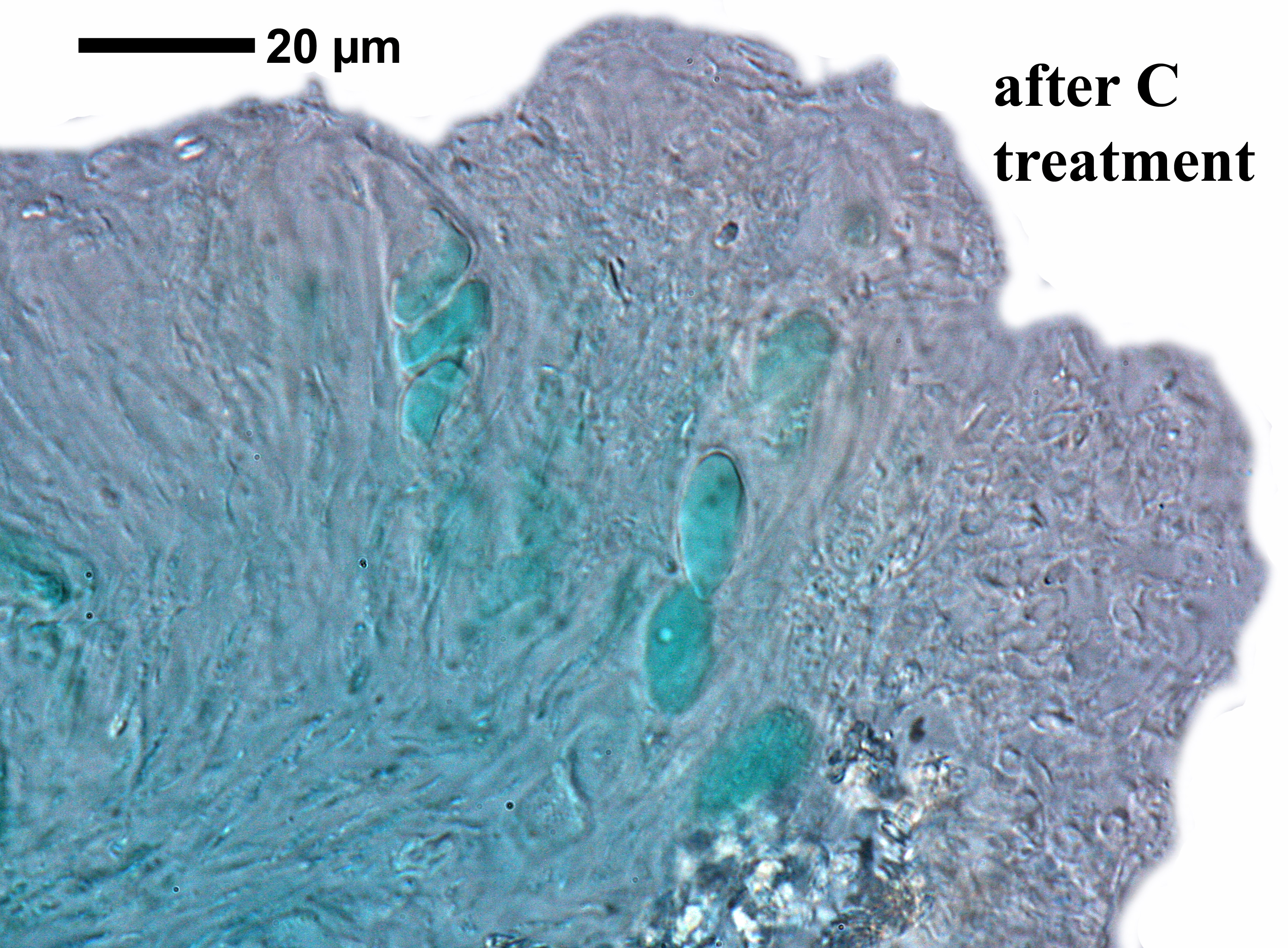
Felix Schumm – CC BY-SA 4.0
[11287], Portugal, Madeira, zwischen Rabaçal und Boca da Encumeada am Ostrand von Paúl da Serra nahe Bica da Cana, licht-, windoffen, tundrenartig, Felsbrocken am Boden. 32°44.225' N, 17°03.653' W, 1530 m. Leg. et det. Schumm 26.12.2003
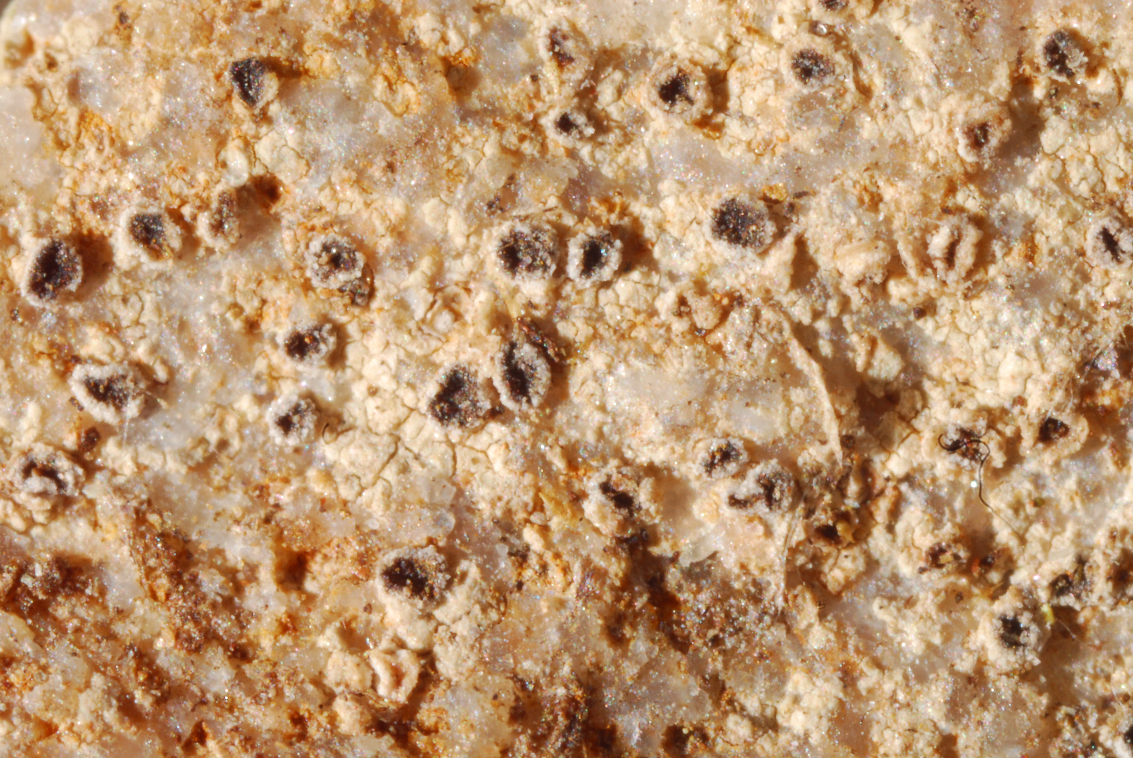
Domenico Puntillo; Owner: Domenico Puntillo
Italy
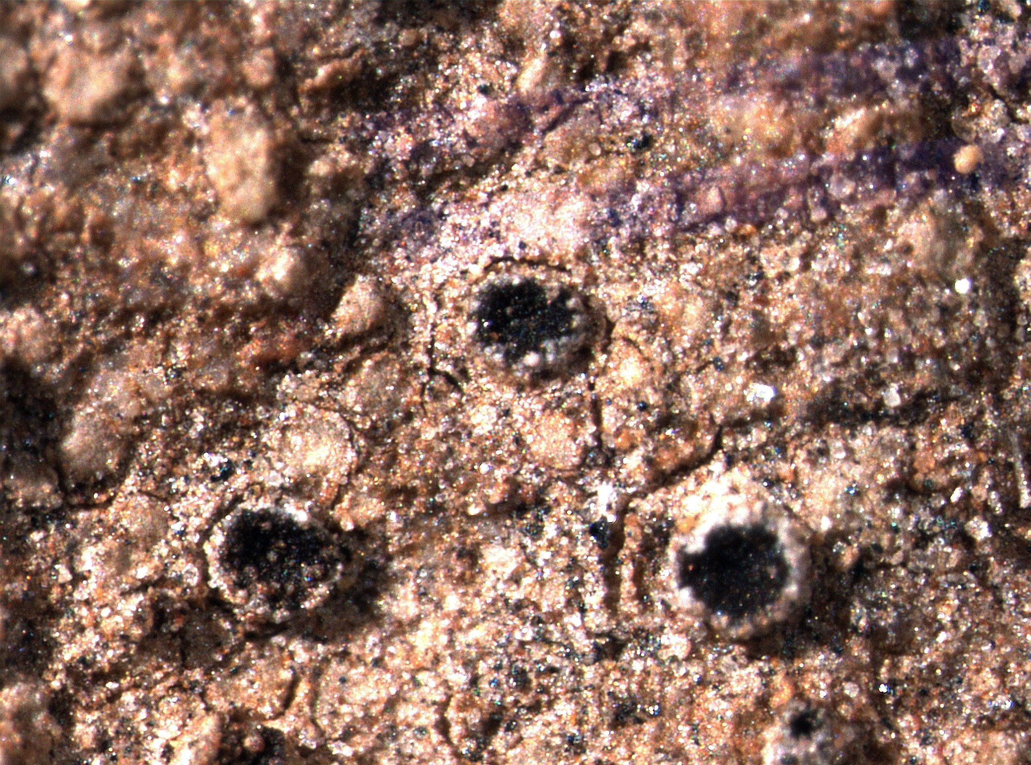
Pier Luigi Nimis - CC BY-SA 4.0
TSB 41855
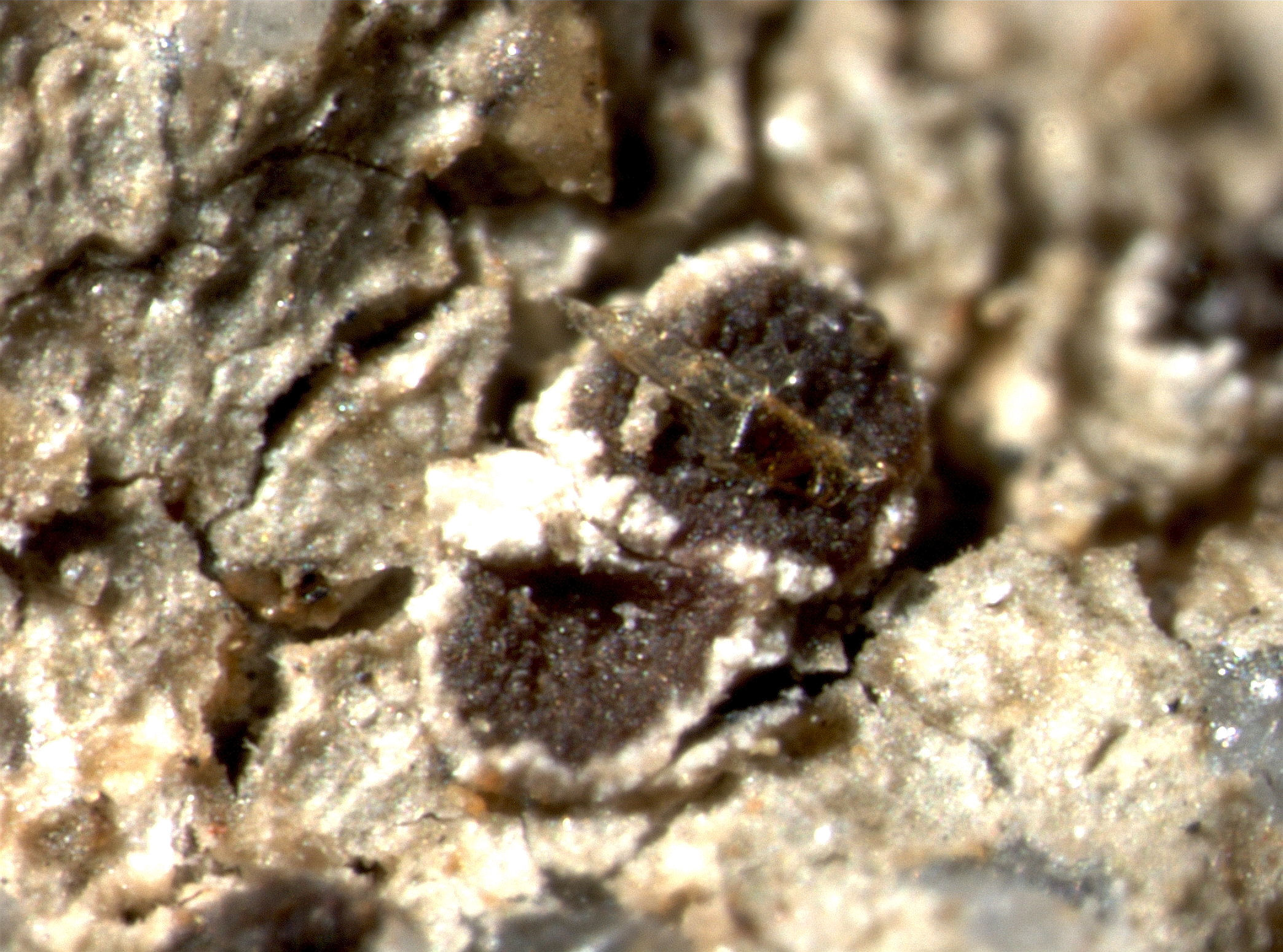
Pier Luigi Nimis - CC BY-SA 4.0
TSB 6799
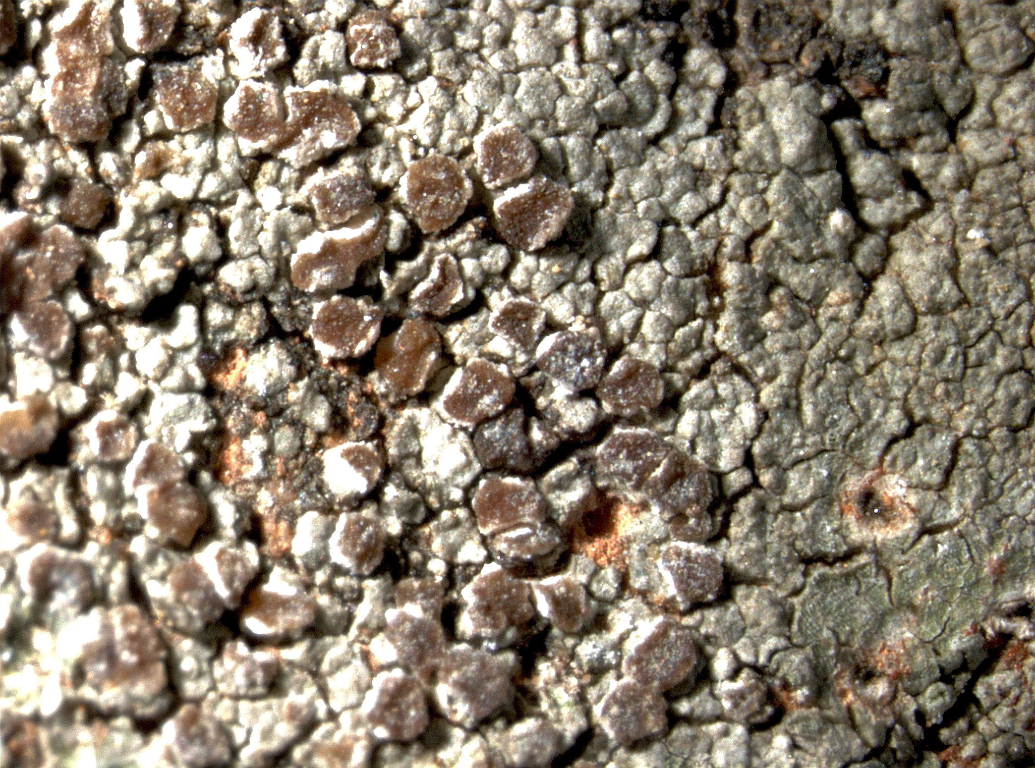
Pier Luigi Nimis - CC BY-SA 4.0
TSB 8346
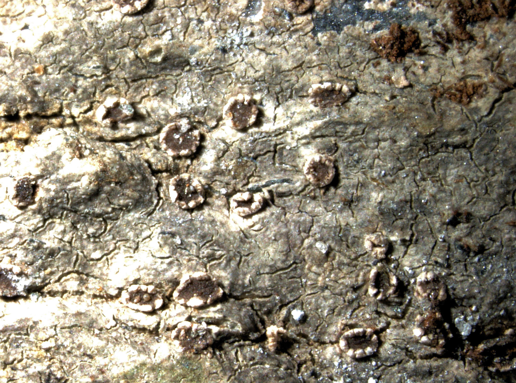
Pier Luigi Nimis - CC BY-SA 4.0
TSB 12261
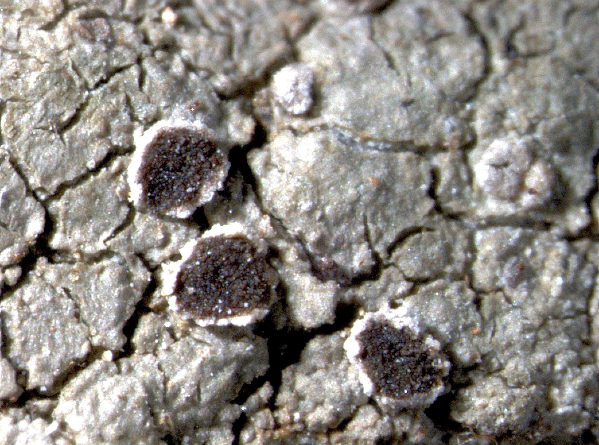
Pier Luigi Nimis - CC BY-SA 4.0
TSB 17649
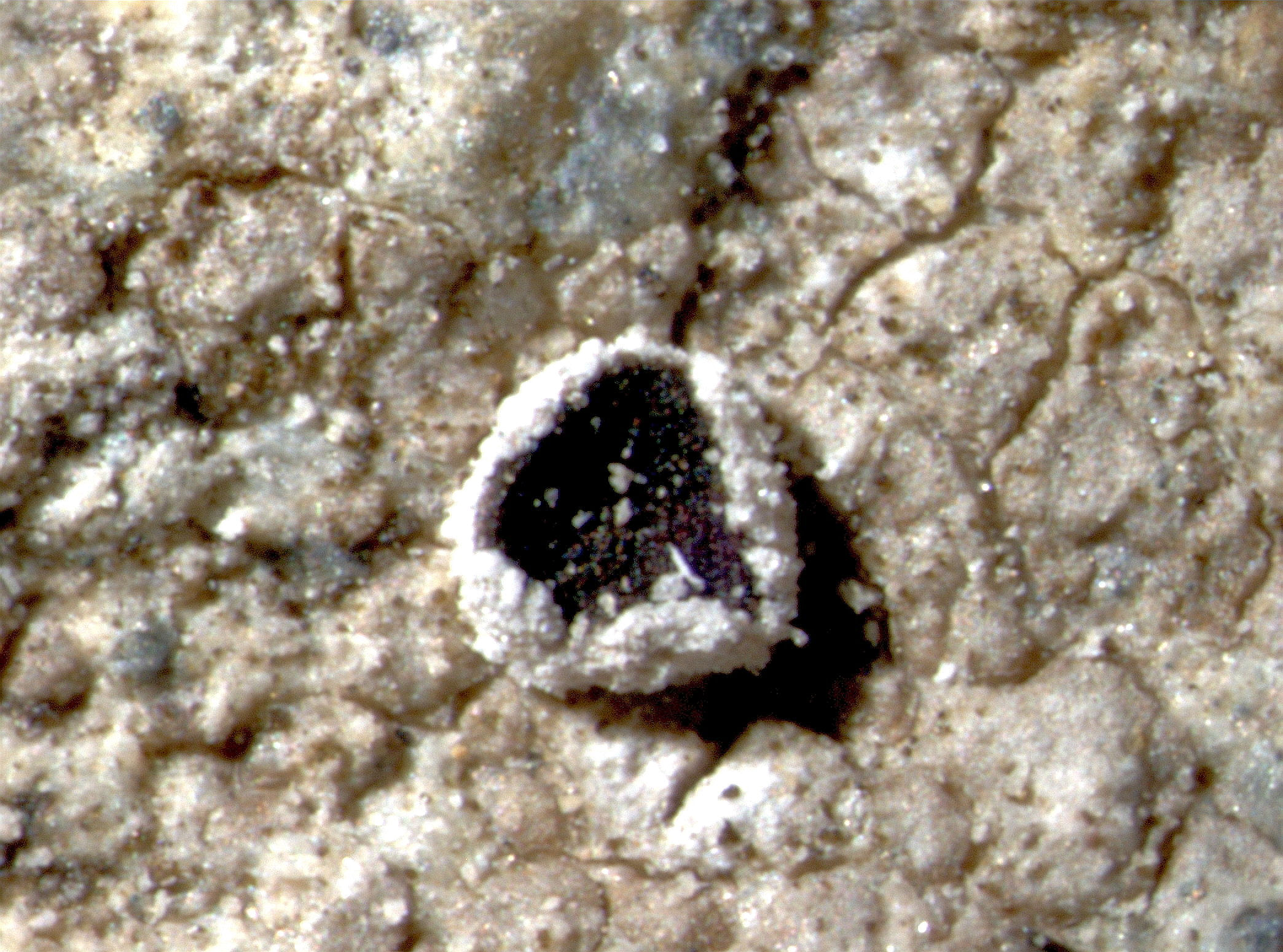
Pier Luigi Nimis - CC BY-SA 4.0
TSB 34140

Pier Luigi Nimis - CC BY-SA 4.0
TSB 38141
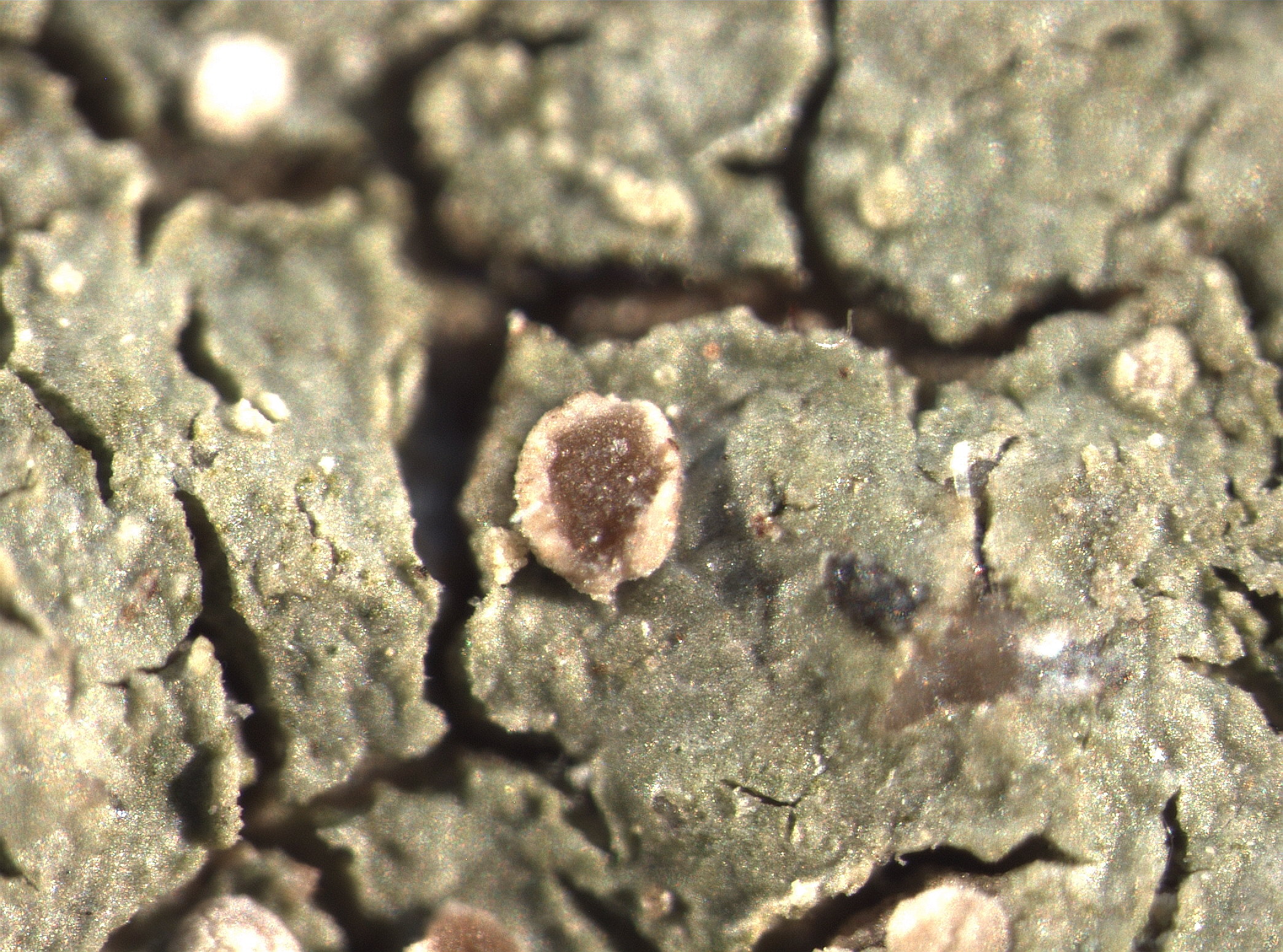
P.L. Nimis CC BY-SA 04
TSB 43706
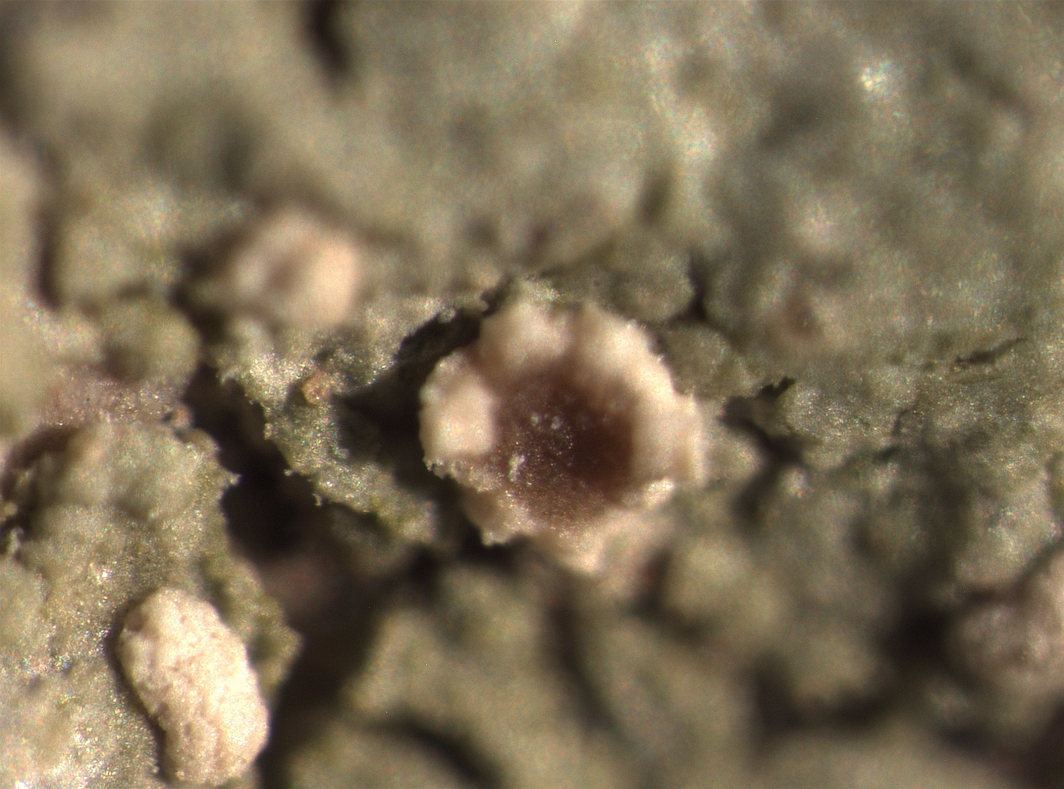
P.L. Nimis CC BY-SA 04
TSB 43706
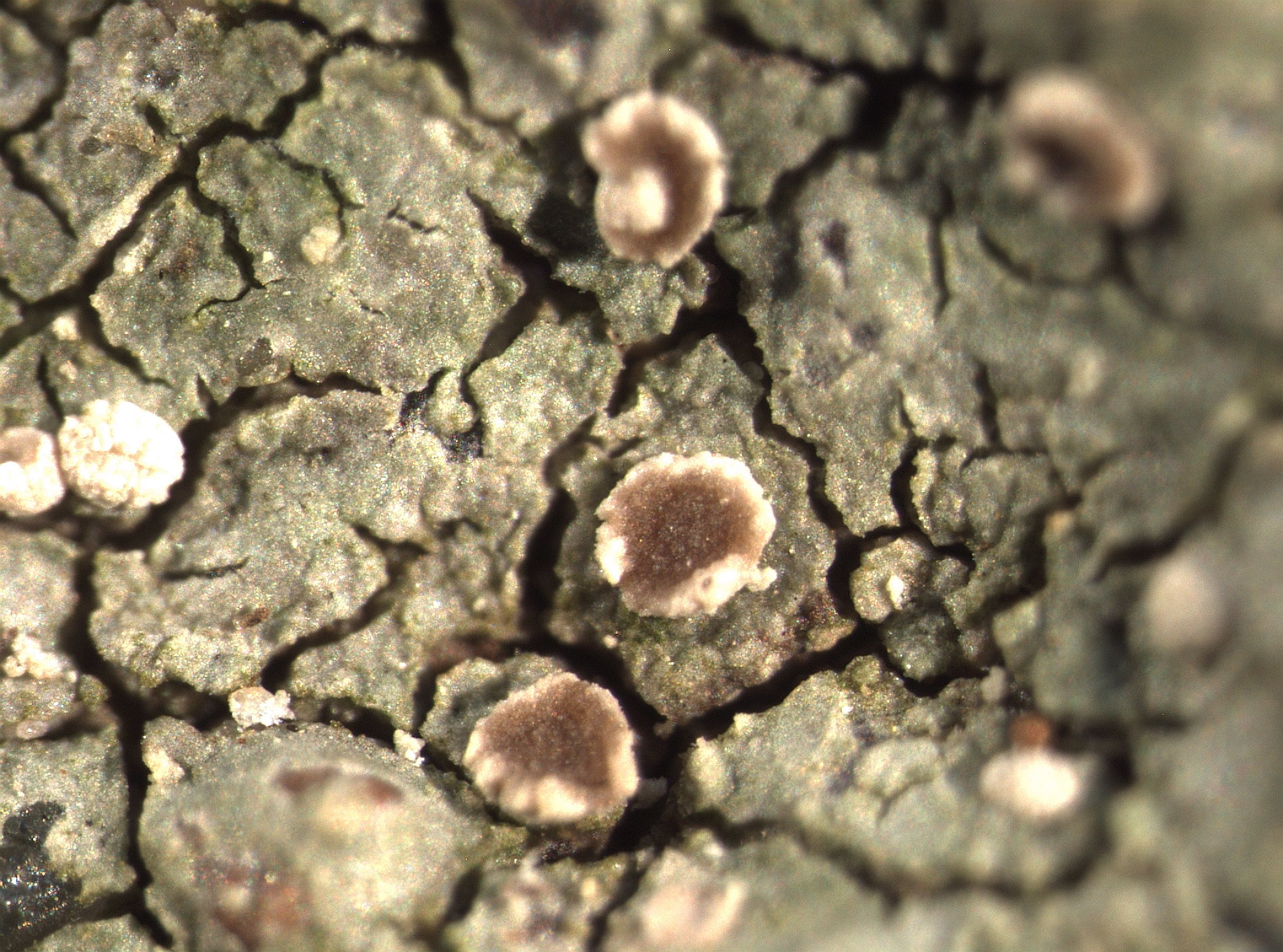
P.L. Nimis CC BY-SA 04
TSB 43706
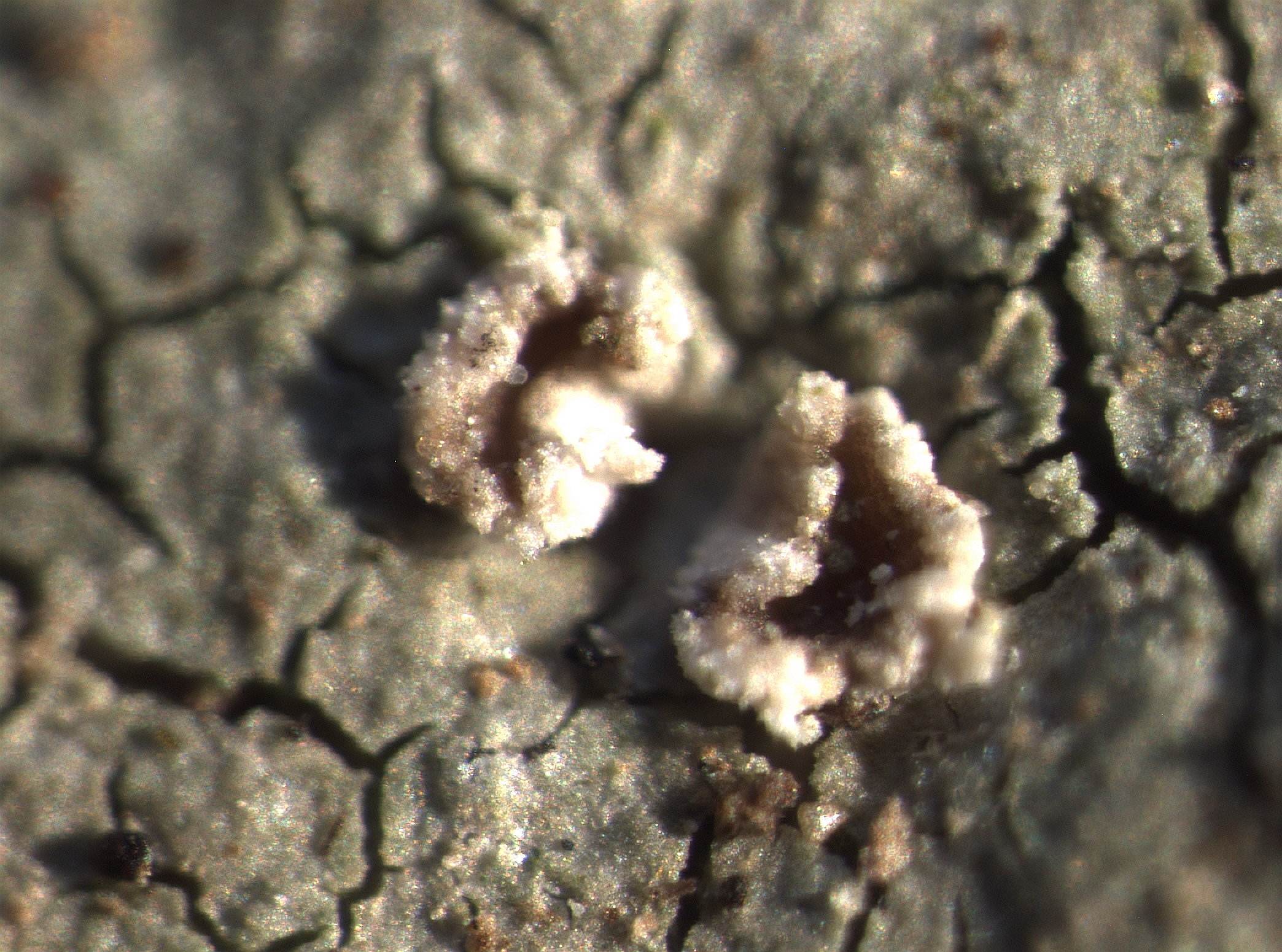
P.L. Nimis CC BY-SA 04
TSB 43706
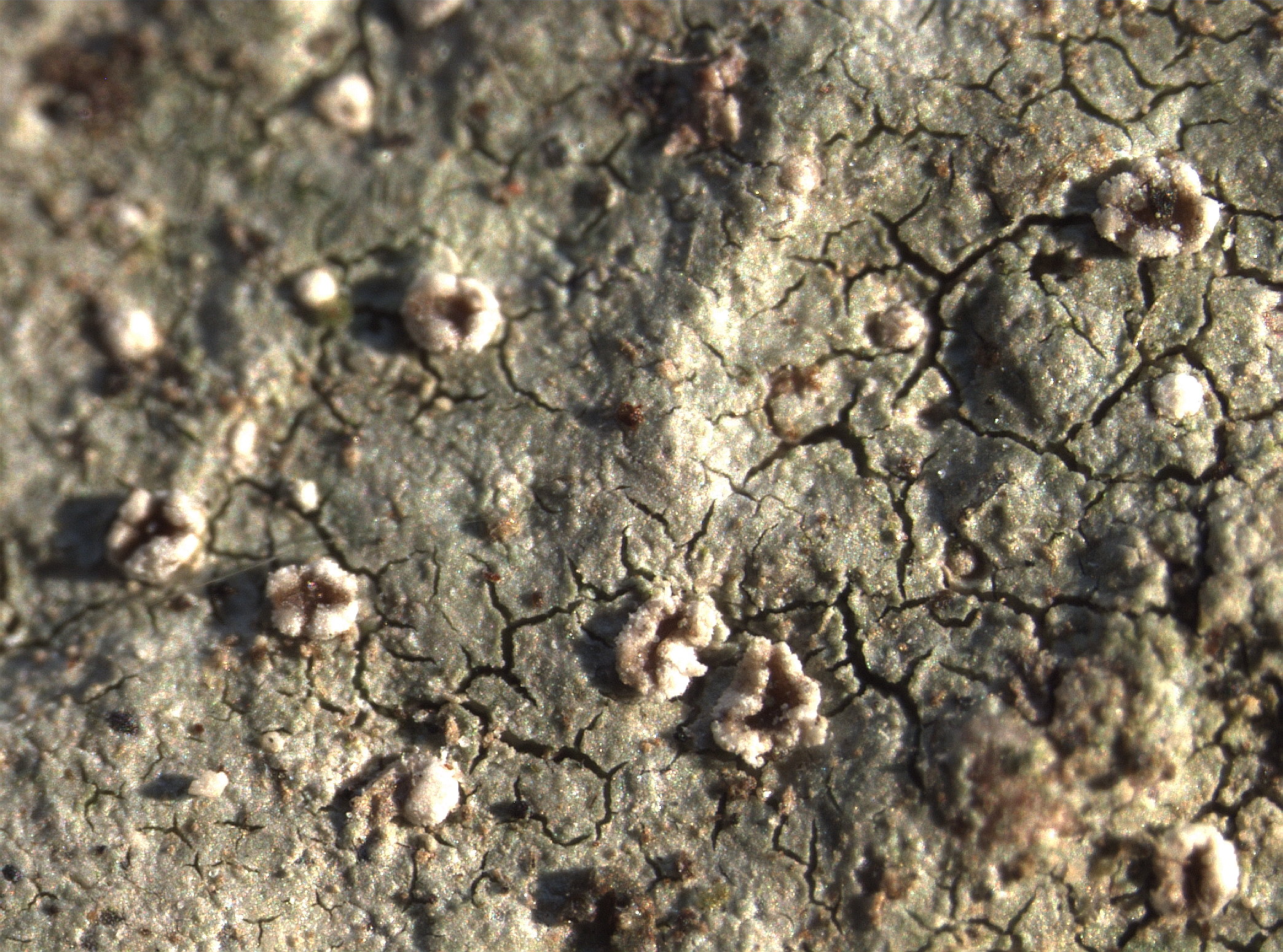
P.L. Nimis CC BY-SA 04
TSB 43706
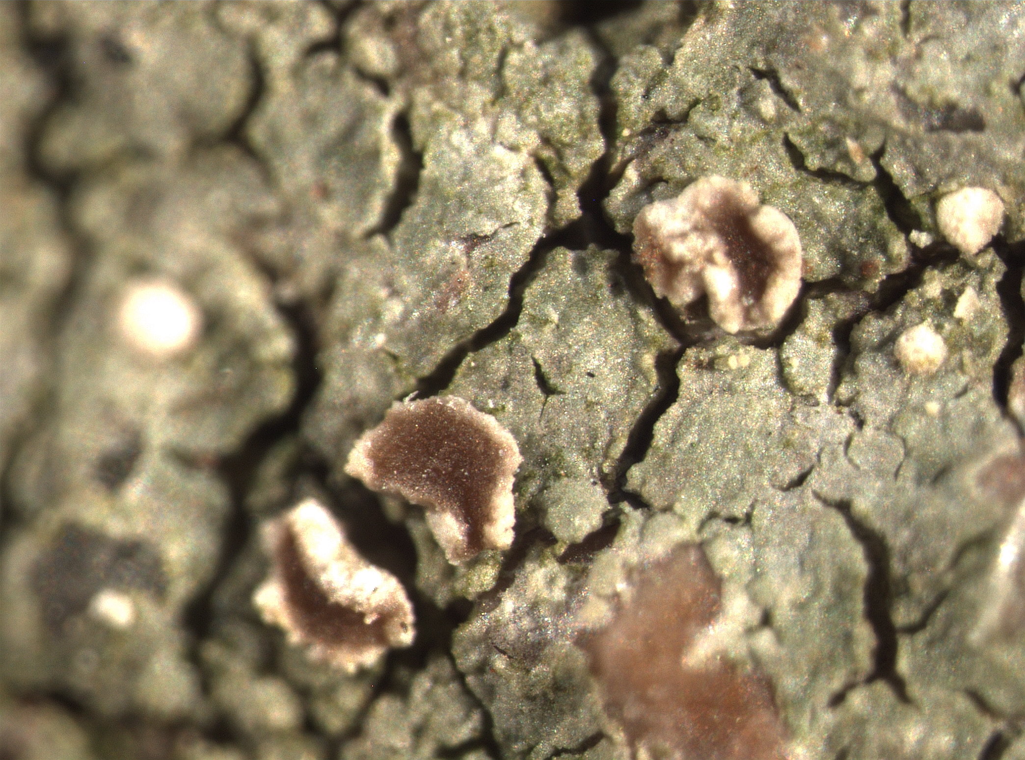
P.L. Nimis CC BY-SA 04
TSB 43706
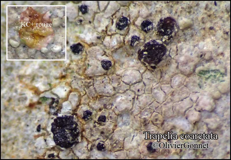
Courtesy Danièle et Olivier Gonnet - Source: https://www.afl-lichenologie.fr/Photos_AFL/Photos_AFL_T/Textes_T2/Trapelia_coarctata.htm
France, 1/6/2015 - session AFL Barcelonnette - Alpes-de-Haute-Provence
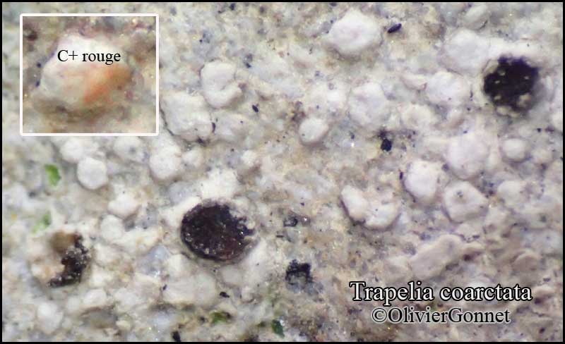
Courtesy Danièle et Olivier Gonnet - Source: https://www.afl-lichenologie.fr/Photos_AFL/Photos_AFL_T/Textes_T2/Trapelia_coarctata.htm
France, 1/6/2015 - session AFL Barcelonnette - Alpes-de-Haute-Provence
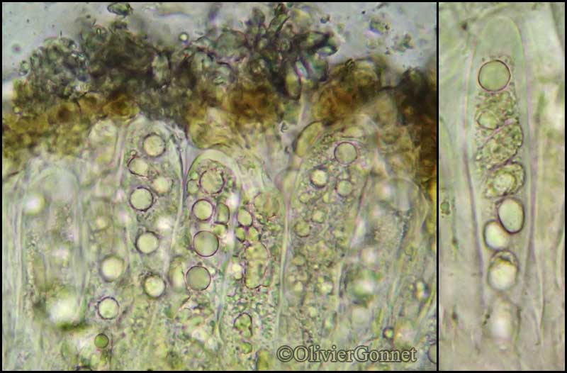
Courtesy Danièle et Olivier Gonnet - Source: https://www.afl-lichenologie.fr/Photos_AFL/Photos_AFL_T/Textes_T2/Trapelia_coarctata.htm
France, 1/6/2015 - session AFL Barcelonnette - Alpes-de-Haute-Provence
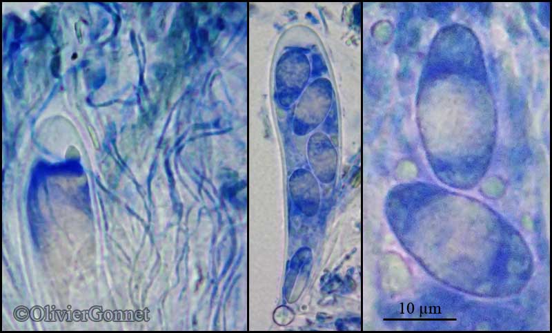
Courtesy Danièle et Olivier Gonnet - Source: https://www.afl-lichenologie.fr/Photos_AFL/Photos_AFL_T/Textes_T2/Trapelia_coarctata.htm
France, 1/6/2015 - session AFL Barcelonnette - Alpes-de-Haute-Provence
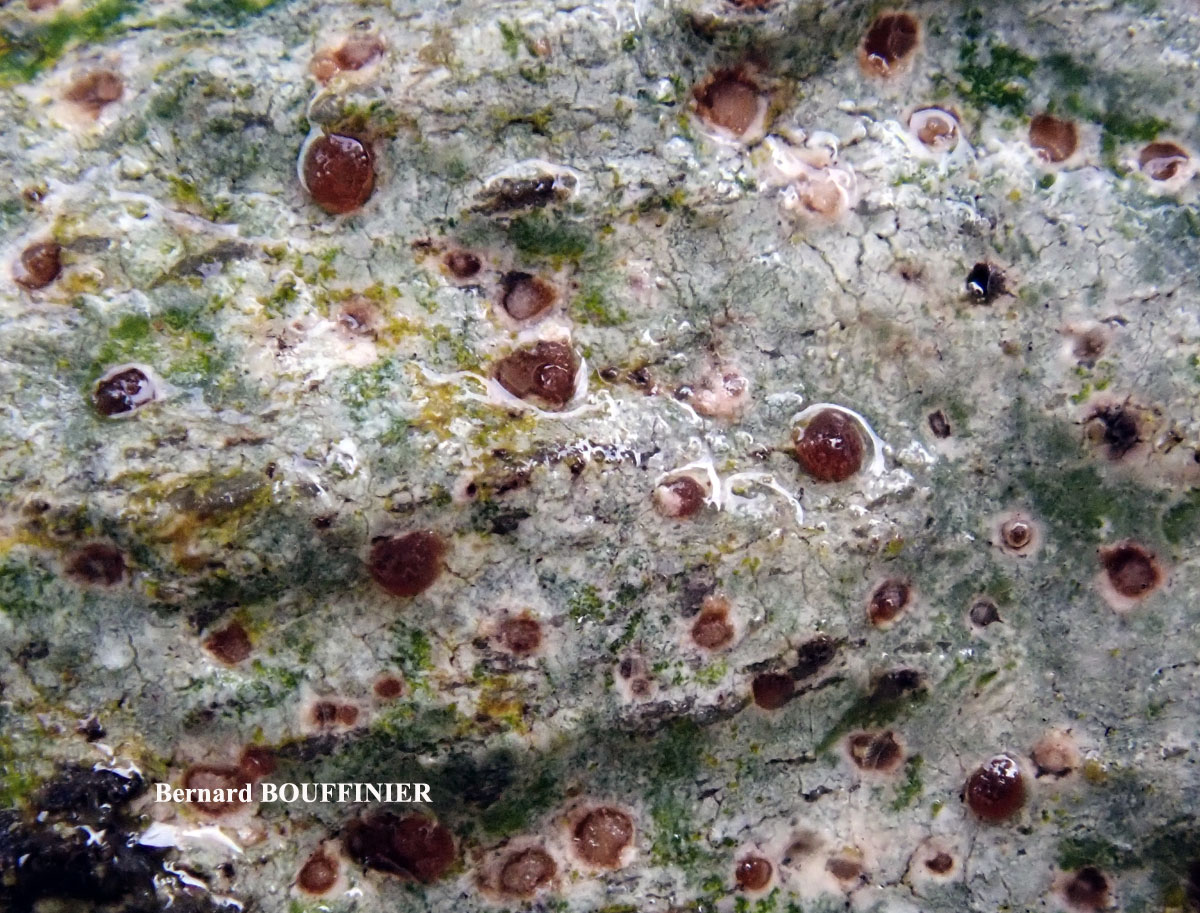
Bernard Bouffinier - Source: http://www.lichensmaritimes.org/index.php?task=fiche&lichen=605&lang=en
France, Châteaulin
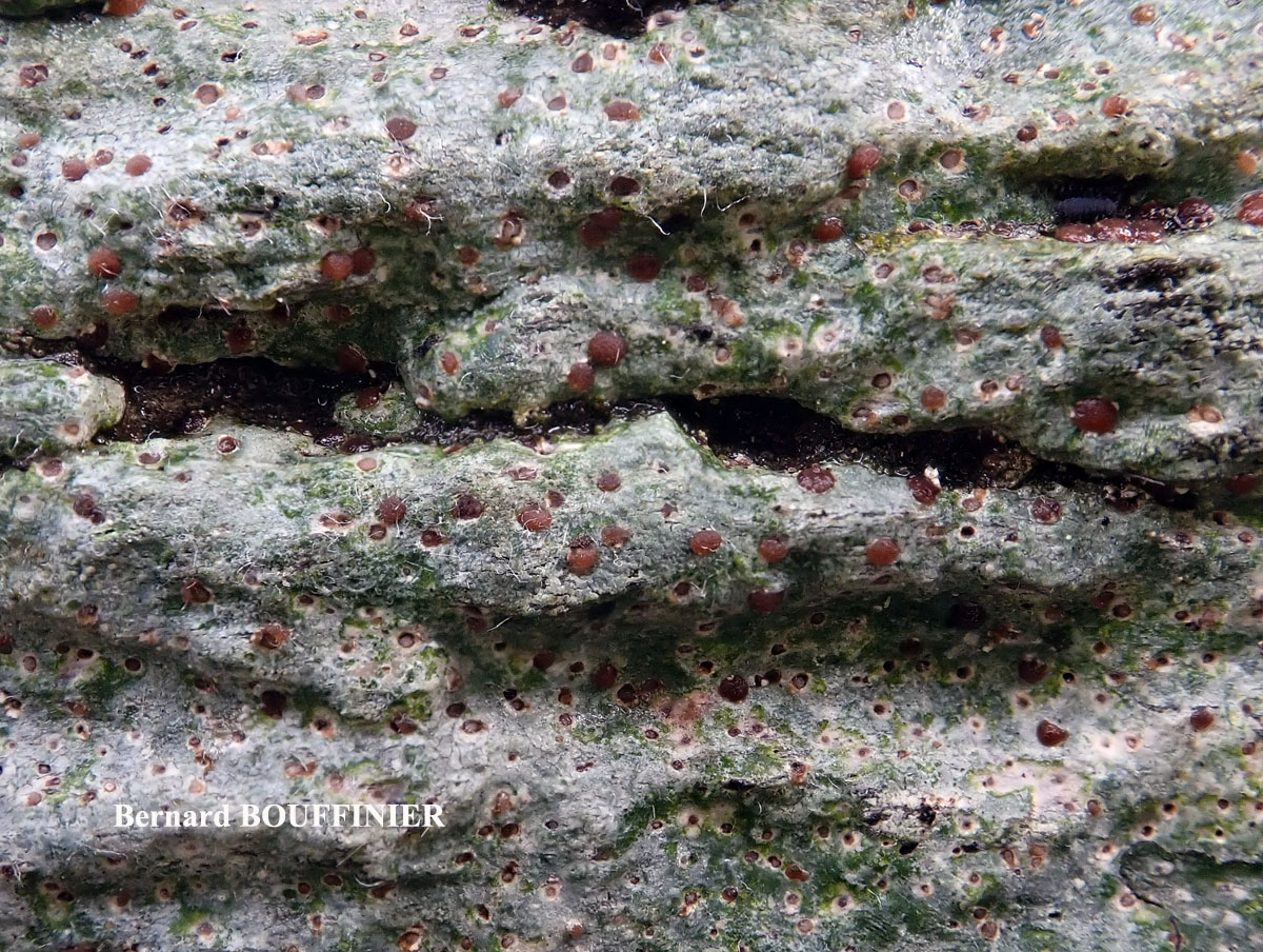
Bernard Bouffinier - Source: http://www.lichensmaritimes.org/index.php?task=fiche&lichen=605&lang=en
France, Châteaulin
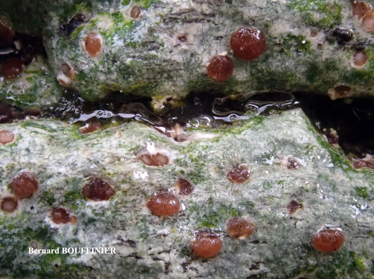
Bernard Bouffinier - Source: http://www.lichensmaritimes.org/index.php?task=fiche&lichen=605&lang=en
France, Châteaulin
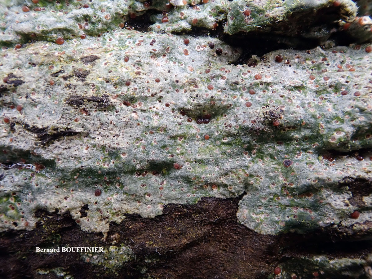
Bernard Bouffinier - Source: http://www.lichensmaritimes.org/index.php?task=fiche&lichen=605&lang=en
France, Châteaulin
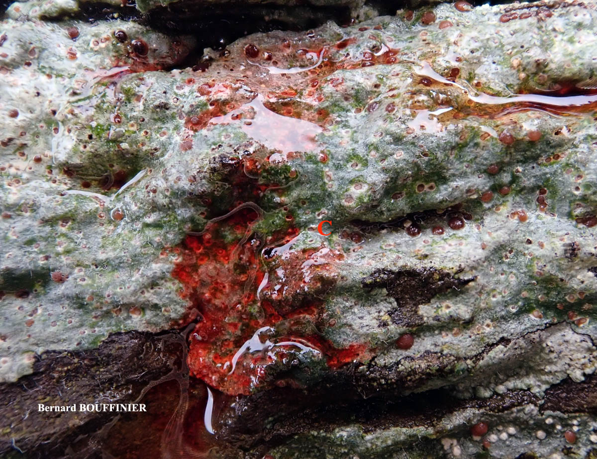
Bernard Bouffinier - Source: http://www.lichensmaritimes.org/index.php?task=fiche&lichen=605&lang=en
France, Châteaulin
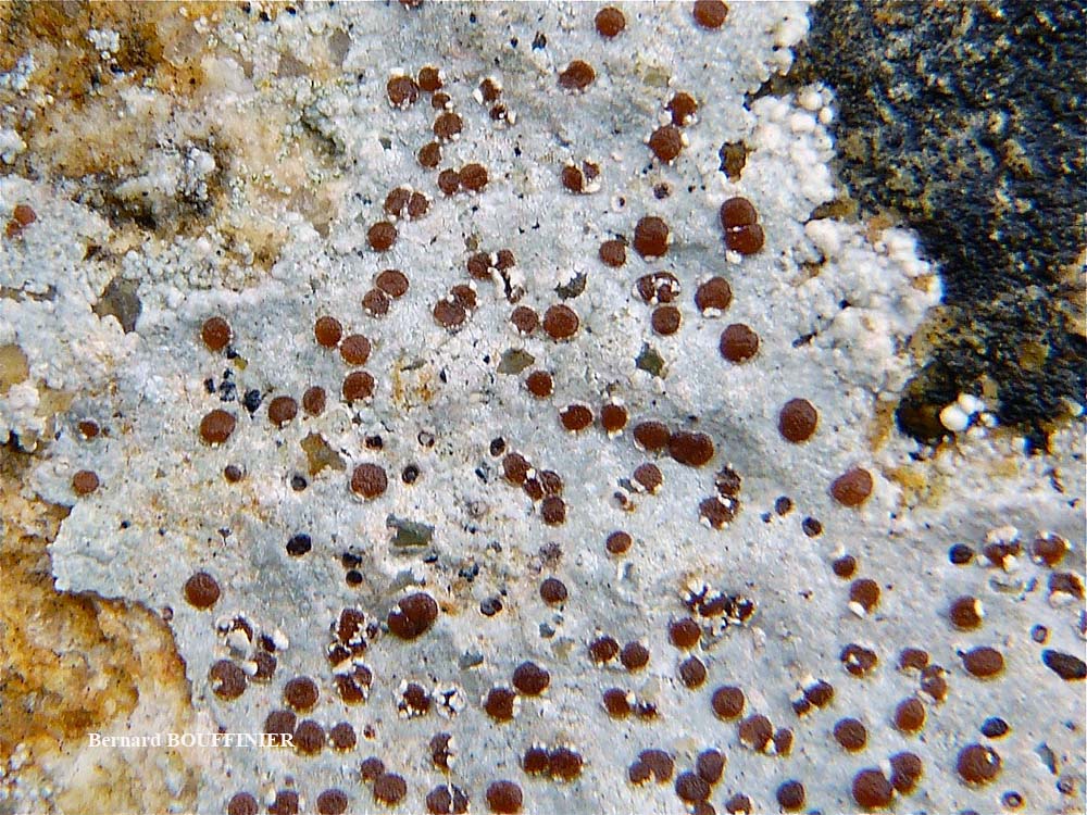
Bernard Bouffinier - Source: http://www.lichensmaritimes.org/index.php?task=fiche&lichen=605&lang=en
France, Scaër
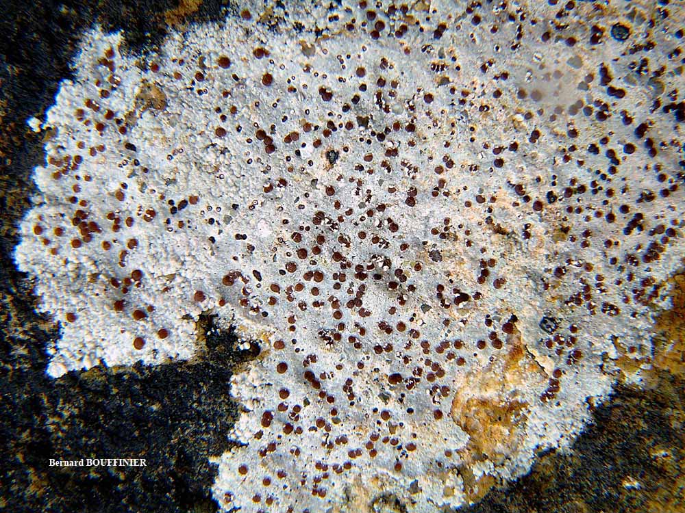
Bernard Bouffinier - Source: http://www.lichensmaritimes.org/index.php?task=fiche&lichen=605&lang=en
France, Scaër
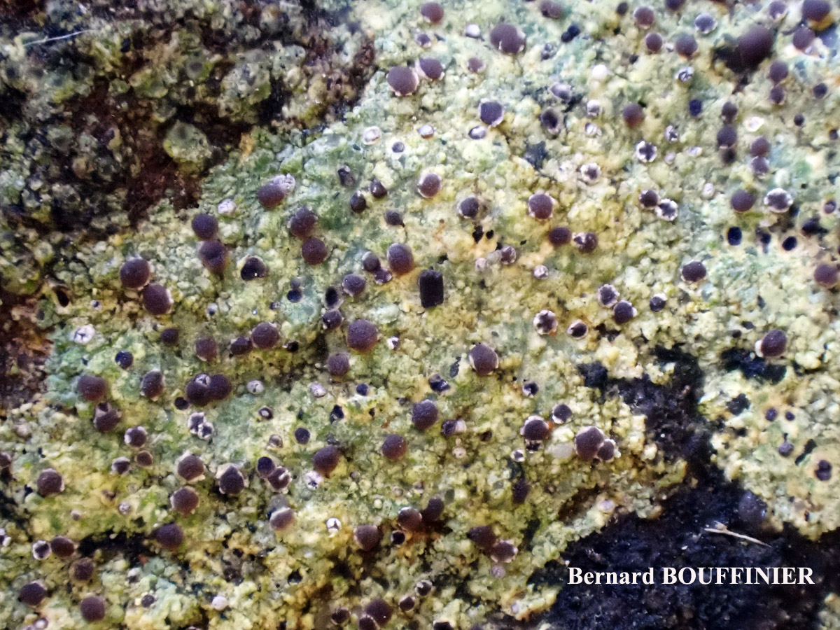
Bernard Bouffinier - Source: http://www.lichensmaritimes.org/index.php?task=fiche&lichen=605&lang=en
France, Roscanvel
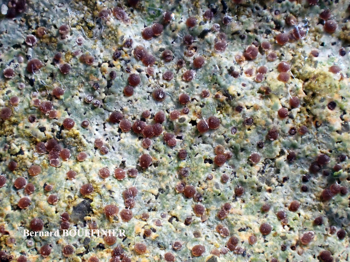
Bernard Bouffinier - Source: http://www.lichensmaritimes.org/index.php?task=fiche&lichen=605&lang=en
France, Roscanvel
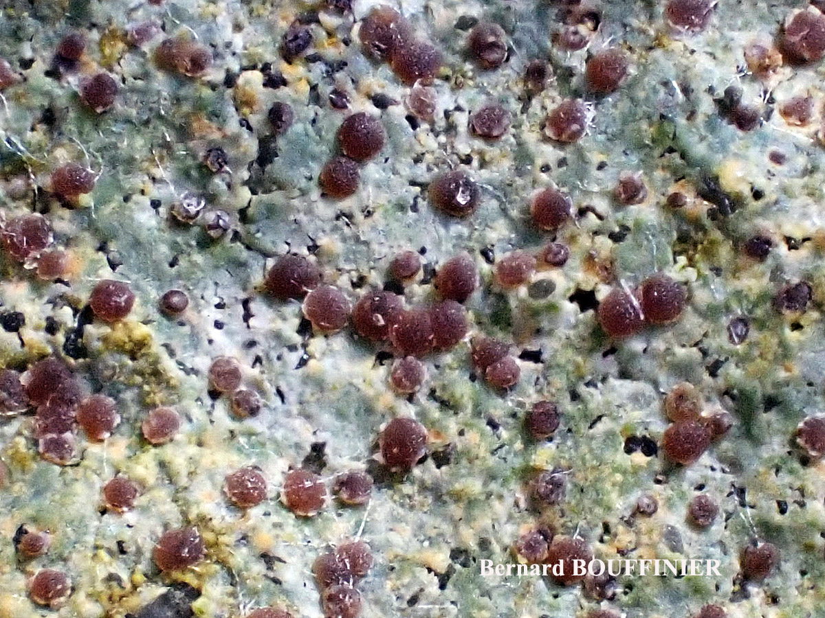
Bernard Bouffinier - Source: http://www.lichensmaritimes.org/index.php?task=fiche&lichen=605&lang=en
France, Roscanvel
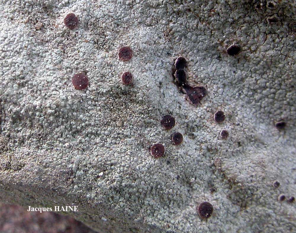
Jacques Haine - Source: http://www.lichensmaritimes.org/index.php?task=fiche&lichen=605&lang=en
France, Ardennes
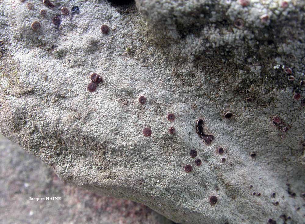
Jacques Haine - Source: http://www.lichensmaritimes.org/index.php?task=fiche&lichen=605&lang=en
France, Ardennes
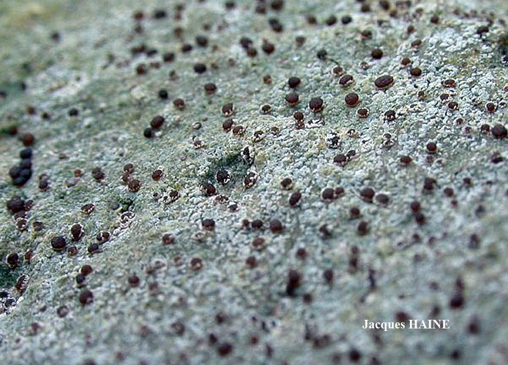
Jacques Haine - Source: http://www.lichensmaritimes.org/index.php?task=fiche&lichen=605&lang=en
France, Ardennes
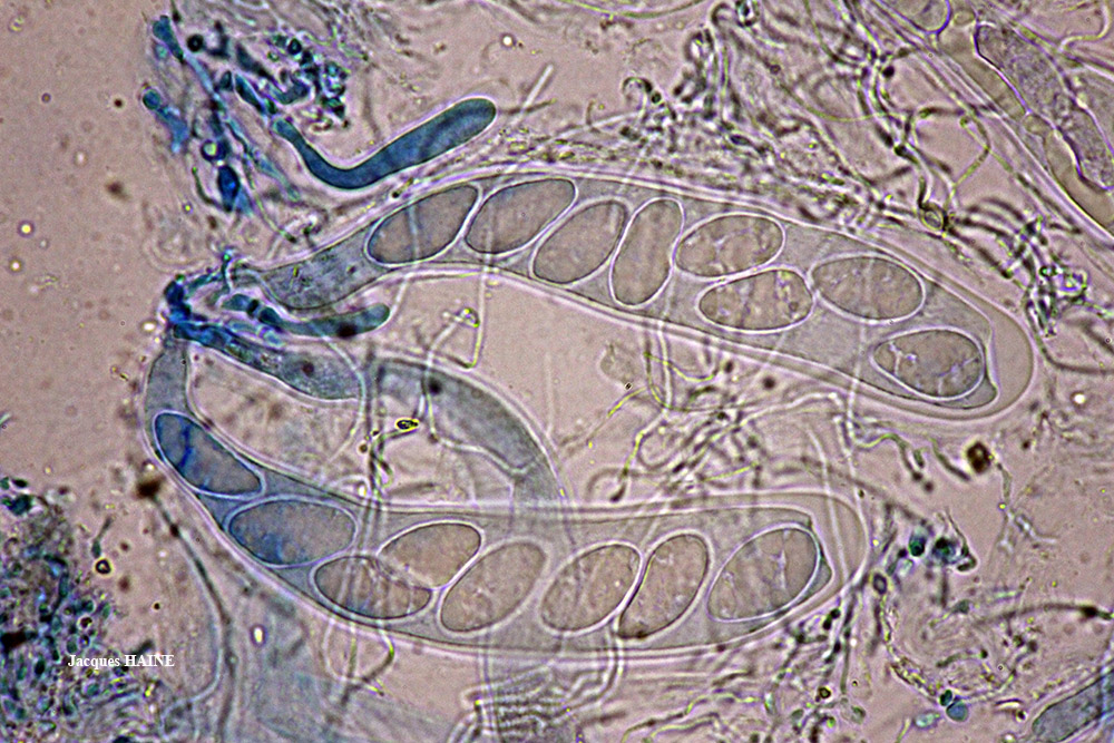
Jacques Haine - Source: http://www.lichensmaritimes.org/index.php?task=fiche&lichen=605&lang=en
France, Ardennes
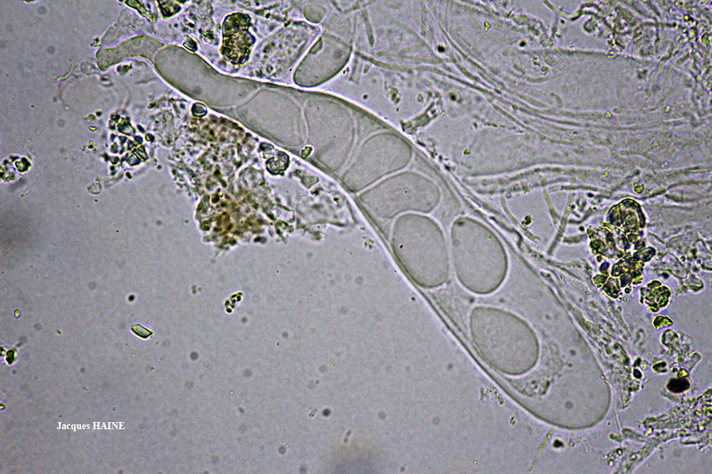
Jacques Haine - Source: http://www.lichensmaritimes.org/index.php?task=fiche&lichen=605&lang=en
France, Ardennes
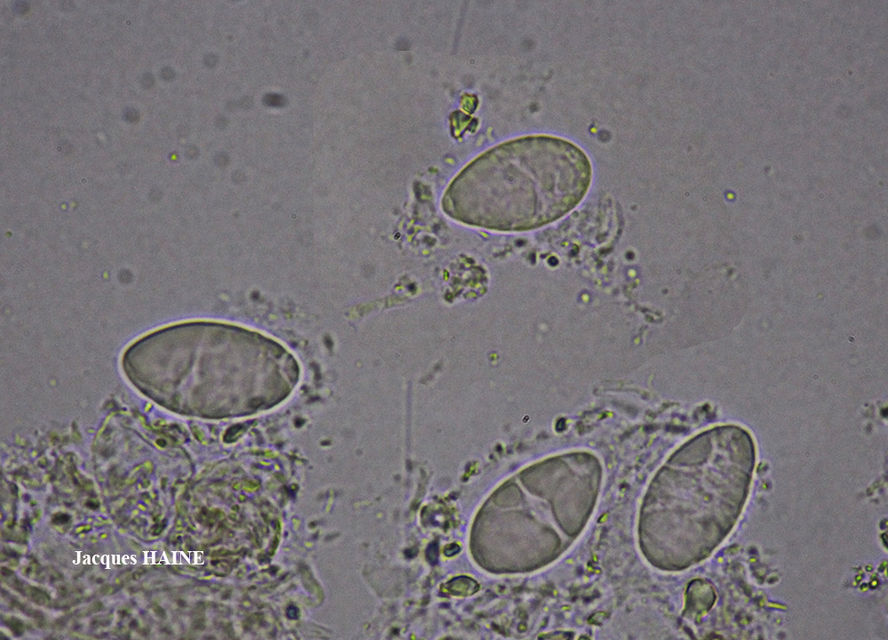
Jacques Haine - Source: http://www.lichensmaritimes.org/index.php?task=fiche&lichen=605&lang=en
France, Ardennes
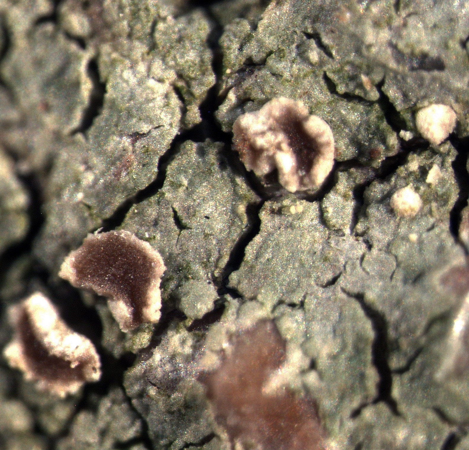
P.L. Nimis CC BY-SA 04
TSB 43706

Wolfgang von Brackel - CC BY-4.0
Germany, Bavaria, Grafenwöhr

Felix Schumm - CC BY 4.0
[11244], Portugal, Azoren, Sao Miguel: SO von Ribeira Grande oberhalb von Lombadas, auf offenem Boden, licht-, nebel- und windoffen. 37°47.173' N, 25°27.894' W, 680 m. Leg. F. Schumm. 07.06.2003. det. F.Schumm 12.2003.

Felix Schumm - CC BY 4.0
[11244], Portugal, Azoren, Sao Miguel: SO von Ribeira Grande oberhalb von Lombadas, auf offenem Boden, licht-, nebel- und windoffen. 37°47.173' N, 25°27.894' W, 680 m. Leg. F. Schumm. 07.06.2003. det. F.Schumm 12.2003.

Felix Schumm - CC BY 4.0
[11244], Portugal, Azoren, Sao Miguel: SO von Ribeira Grande oberhalb von Lombadas, auf offenem Boden, licht-, nebel- und windoffen. 37°47.173' N, 25°27.894' W, 680 m. Leg. F. Schumm. 07.06.2003. det. F.Schumm 12.2003.

Felix Schumm - CC BY 4.0
[11244], Portugal, Azoren, Sao Miguel: SO von Ribeira Grande oberhalb von Lombadas, auf offenem Boden, licht-, nebel- und windoffen. 37°47.173' N, 25°27.894' W, 680 m. Leg. F. Schumm. 07.06.2003. det. F.Schumm 12.2003.

Felix Schumm - CC BY 4.0
[11244], Portugal, Azoren, Sao Miguel: SO von Ribeira Grande oberhalb von Lombadas, auf offenem Boden, licht-, nebel- und windoffen. 37°47.173' N, 25°27.894' W, 680 m. Leg. F. Schumm. 07.06.2003. det. F.Schumm 12.2003.

Felix Schumm - CC BY 4.0
[11244], Portugal, Azoren, Sao Miguel: SO von Ribeira Grande oberhalb von Lombadas, auf offenem Boden, licht-, nebel- und windoffen. 37°47.173' N, 25°27.894' W, 680 m. Leg. F. Schumm. 07.06.2003. det. F.Schumm 12.2003.

Felix Schumm - CC BY 4.0
[11244], Portugal, Azoren, Sao Miguel: SO von Ribeira Grande oberhalb von Lombadas, auf offenem Boden, licht-, nebel- und windoffen. 37°47.173' N, 25°27.894' W, 680 m. Leg. F. Schumm. 07.06.2003. det. F.Schumm 12.2003.

Felix Schumm - CC BY 4.0
[11244], Portugal, Azoren, Sao Miguel: SO von Ribeira Grande oberhalb von Lombadas, auf offenem Boden, licht-, nebel- und windoffen. 37°47.173' N, 25°27.894' W, 680 m. Leg. F. Schumm. 07.06.2003. det. F.Schumm 12.2003.

Felix Schumm - CC BY 4.0
[11287]. PORTUGAL, MADEIRA: Zwischen Rabaçal und Boca da Encumeada am Ostrand von Paúl da Serra nahe Bica da Cana, licht-, windoffen, tundrenartig, Felsbrocken am Boden, 32°44.225' N, 17°03.653' W, 1530 m. Leg. F. Schumm 26.12.2003, det. F. Schumm 2011, test et conf. Aptroot 2011.

Felix Schumm - CC BY 4.0
[11287]. PORTUGAL, MADEIRA: Zwischen Rabaçal und Boca da Encumeada am Ostrand von Paúl da Serra nahe Bica da Cana, licht-, windoffen, tundrenartig, Felsbrocken am Boden, 32°44.225' N, 17°03.653' W, 1530 m. Leg. F. Schumm 26.12.2003, det. F. Schumm 2011, test et conf. Aptroot 2011.

Felix Schumm - CC BY 4.0
[11287]. PORTUGAL, MADEIRA: Zwischen Rabaçal und Boca da Encumeada am Ostrand von Paúl da Serra nahe Bica da Cana, licht-, windoffen, tundrenartig, Felsbrocken am Boden, 32°44.225' N, 17°03.653' W, 1530 m. Leg. F. Schumm 26.12.2003, det. F. Schumm 2011, test et conf. Aptroot 2011.

Felix Schumm - CC BY 4.0
[17278], Germany, Baden-Württemberg, Schwarzwald-Baar-Kreis, zwischen Villingen und Stockburg, ca. 3 km NW von Villingen, 48.071988° N, 8.419199° E, 740 m. An Granit. Leg. F. F.Schumm 03.06.2011, det. F.Schumm 2011, test. Aptroot 2011.

Felix Schumm - CC BY 4.0
[17278], Germany, Baden-Württemberg, Schwarzwald-Baar-Kreis, zwischen Villingen und Stockburg, ca. 3 km NW von Villingen, 48.071988° N, 8.419199° E, 740 m. An Granit. Leg. F. F.Schumm 03.06.2011, det. F.Schumm 2011, test. Aptroot 2011.

Felix Schumm - CC BY 4.0
[17278], Germany, Baden-Württemberg, Schwarzwald-Baar-Kreis, zwischen Villingen und Stockburg, ca. 3 km NW von Villingen, 48.071988° N, 8.419199° E, 740 m. An Granit. Leg. F. F.Schumm 03.06.2011, det. F.Schumm 2011, test. Aptroot 2011.

Felix Schumm - CC BY 4.0
[17278], Germany, Baden-Württemberg, Schwarzwald-Baar-Kreis, zwischen Villingen und Stockburg, ca. 3 km NW von Villingen, 48.071988° N, 8.419199° E, 740 m. An Granit. Leg. F. F.Schumm 03.06.2011, det. F.Schumm 2011, test. Aptroot 2011.

Felix Schumm - CC BY 4.0
[17278], Germany, Baden-Württemberg, Schwarzwald-Baar-Kreis, zwischen Villingen und Stockburg, ca. 3 km NW von Villingen, 48.071988° N, 8.419199° E, 740 m. An Granit. Leg. F. F.Schumm 03.06.2011, det. F.Schumm 2011, test. Aptroot 2011.

Felix Schumm - CC BY 4.0
[17278], Germany, Baden-Württemberg, Schwarzwald-Baar-Kreis, zwischen Villingen und Stockburg, ca. 3 km NW von Villingen, 48.071988° N, 8.419199° E, 740 m. An Granit. Leg. F. F.Schumm 03.06.2011, det. F.Schumm 2011, test. Aptroot 2011.

Felix Schumm - CC BY 4.0
[17278], Germany, Baden-Württemberg, Schwarzwald-Baar-Kreis, zwischen Villingen und Stockburg, ca. 3 km NW von Villingen, 48.071988° N, 8.419199° E, 740 m. An Granit. Leg. F. F.Schumm 03.06.2011, det. F.Schumm 2011, test. Aptroot 2011.

Felix Schumm - CC BY 4.0
[17278], Germany, Baden-Württemberg, Schwarzwald-Baar-Kreis, zwischen Villingen und Stockburg, ca. 3 km NW von Villingen, 48.071988° N, 8.419199° E, 740 m. An Granit. Leg. F. F.Schumm 03.06.2011, det. F.Schumm 2011, test. Aptroot 2011.

Felix Schumm - CC BY 4.0
[17278], Germany, Baden-Württemberg, Schwarzwald-Baar-Kreis, zwischen Villingen und Stockburg, ca. 3 km NW von Villingen, 48.071988° N, 8.419199° E, 740 m. An Granit. Leg. F. F.Schumm 03.06.2011, det. F.Schumm 2011, test. Aptroot 2011.

Felix Schumm - CC BY 4.0
[17278], Germany, Baden-Württemberg, Schwarzwald-Baar-Kreis, zwischen Villingen und Stockburg, ca. 3 km NW von Villingen, 48.071988° N, 8.419199° E, 740 m. An Granit. Leg. F. F.Schumm 03.06.2011, det. F.Schumm 2011, test. Aptroot 2011.

Felix Schumm - CC BY 4.0
[17278], Germany, Baden-Württemberg, Schwarzwald-Baar-Kreis, zwischen Villingen und Stockburg, ca. 3 km NW von Villingen, 48.071988° N, 8.419199° E, 740 m. An Granit. Leg. F. F.Schumm 03.06.2011, det. F.Schumm 2011, test. Aptroot 2011.

Felix Schumm - CC BY 4.0
[17278], Germany, Baden-Württemberg, Schwarzwald-Baar-Kreis, zwischen Villingen und Stockburg, ca. 3 km NW von Villingen, 48.071988° N, 8.419199° E, 740 m. An Granit. Leg. F. F.Schumm 03.06.2011, det. F.Schumm 2011, test. Aptroot 2011.

Felix Schumm - CC BY 4.0
[17278], Germany, Baden-Württemberg, Schwarzwald-Baar-Kreis, zwischen Villingen und Stockburg, ca. 3 km NW von Villingen, 48.071988° N, 8.419199° E, 740 m. An Granit. Leg. F. F.Schumm 03.06.2011, det. F.Schumm 2011, test. Aptroot 2011.

Felix Schumm - CC BY 4.0
[17278], Germany, Baden-Württemberg, Schwarzwald-Baar-Kreis, zwischen Villingen und Stockburg, ca. 3 km NW von Villingen, 48.071988° N, 8.419199° E, 740 m. An Granit. Leg. F. F.Schumm 03.06.2011, det. F.Schumm 2011, test. Aptroot 2011.

Felix Schumm - CC BY 4.0
[20287], Germany, Baden-Württemberg, Kreis Göppingen, Wangen, auf am Boden liegenden Sandsteinen im Fichtenwald. 48,73047° N, 9,60053° E, 300m. Leg. F. Schumm, 14.02.2019, det. F. Schumm.

Felix Schumm - CC BY 4.0
[20287], Germany, Baden-Württemberg, Kreis Göppingen, Wangen, auf am Boden liegenden Sandsteinen im Fichtenwald. 48,73047° N, 9,60053° E, 300m. Leg. F. Schumm, 14.02.2019, det. F. Schumm.

Felix Schumm - CC BY 4.0
[20287], Germany, Baden-Württemberg, Kreis Göppingen, Wangen, auf am Boden liegenden Sandsteinen im Fichtenwald. 48,73047° N, 9,60053° E, 300m. Leg. F. Schumm, 14.02.2019, det. F. Schumm.

Felix Schumm - CC BY 4.0
[VZ2236], Bohemoslovacia. Moravia, distr. Brno, inter pagos Sob ice et Mokrá Hora, 250 m. Ad terram nudam in fossis viae silvaticae. Leg. A. Vezda, 9.1.1988. EX A. VEZDA LICHENES SELECTI EXSICCATI NR. 2236.

Felix Schumm - CC BY 4.0
[VZ2236], Bohemoslovacia. Moravia, distr. Brno, inter pagos Sob ice et Mokrá Hora, 250 m. Ad terram nudam in fossis viae silvaticae. Leg. A. Vezda, 9.1.1988. EX A. VEZDA LICHENES SELECTI EXSICCATI NR. 2236.

Photo by Heikel Balti - CC BY-SA 4.0
France 05/02/2023 Petit-Croix, Territoire de Belfort (90) on calcareous stone blocks close to the ground leg., det. and herb. H. Balti, conf. Y. Ferrez

Photo by Heikel Balti - CC BY-SA 4.0
France 05/02/2023 Petit-Croix, Territoire de Belfort (90) on calcareous stone blocks close to the ground leg., det. and herb. H. Balti, conf. Y. Ferrez

Photo by Heikel Balti - CC BY-SA 4.0
France 05/02/2023 Petit-Croix, Territoire de Belfort (90) on calcareous stone blocks close to the ground leg., det. and herb. H. Balti, conf. Y. Ferrez

Photo by Heikel Balti - CC BY-SA 4.0
France 05/02/2023 Petit-Croix, Territoire de Belfort (90) on calcareous stone blocks close to the ground leg., det. and herb. H. Balti, conf. Y. Ferrez

Photo by Heikel Balti - CC BY-SA 4.0
France 05/02/2023 Petit-Croix, Territoire de Belfort (90) on calcareous stone blocks close to the ground leg., det. and herb. H. Balti, conf. Y. Ferrez

Photo by Heikel Balti - CC BY-SA 4.0
France 05/02/2023 Petit-Croix, Territoire de Belfort (90) on calcareous stone blocks close to the ground leg., det. and herb. H. Balti, conf. Y. Ferrez