Tornabea scutellifera (With.) J.R. Laundon
Lichenologist, 16: 226, 1984. Basionym: Lichen scutelliferus With. - Bot. Arrang. Veget. Gr. Brit.: 728, 1776.
Synonyms: Anaptychia intricata (DC.) A. Massal.; Parmelia atlantica Ach.; Teloschistes intricatus (DC.) Hue; Tornabea atlantica (Ach.) Østh.; Tornabea atlantica var. intricata (DC.) Clauzade & Cl. Roux; Tornabenia atlantica (Ach.) Kurok.; Tornabeniopsis atlantica (Ach.) Follmann comb.inval.
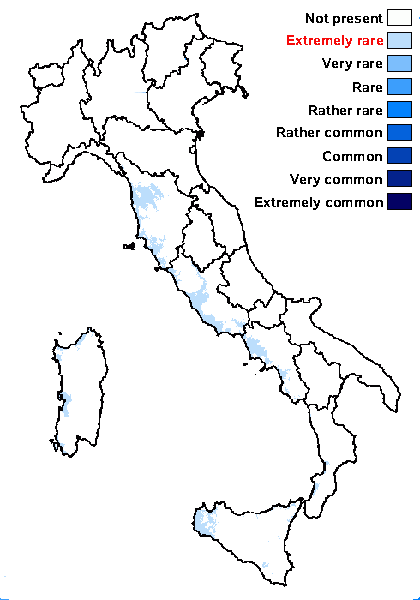
Distribution: C - Tosc (Nimis & Tretiach 1997), Laz (Lich. Graec. 39: Obermayer 1995b, Nimis & Tretiach 1997, Nordin & Mattsson 2001, Lich. Graec. 499: Obermayer 2019), Sar (Nimis & Tretiach 1997, Watson 2014). S - Camp (Nimis & Tretiach 1997), Pugl (Nimis & Tretiach 1997, 1999), Cal (CLU 8169), Si (Nimis & al. 1994, Ottonello & Salone 1994, Ottonello & al. 1994, 2011, Nimis & Tretiach 1997, Ottonello & Romano 1997).
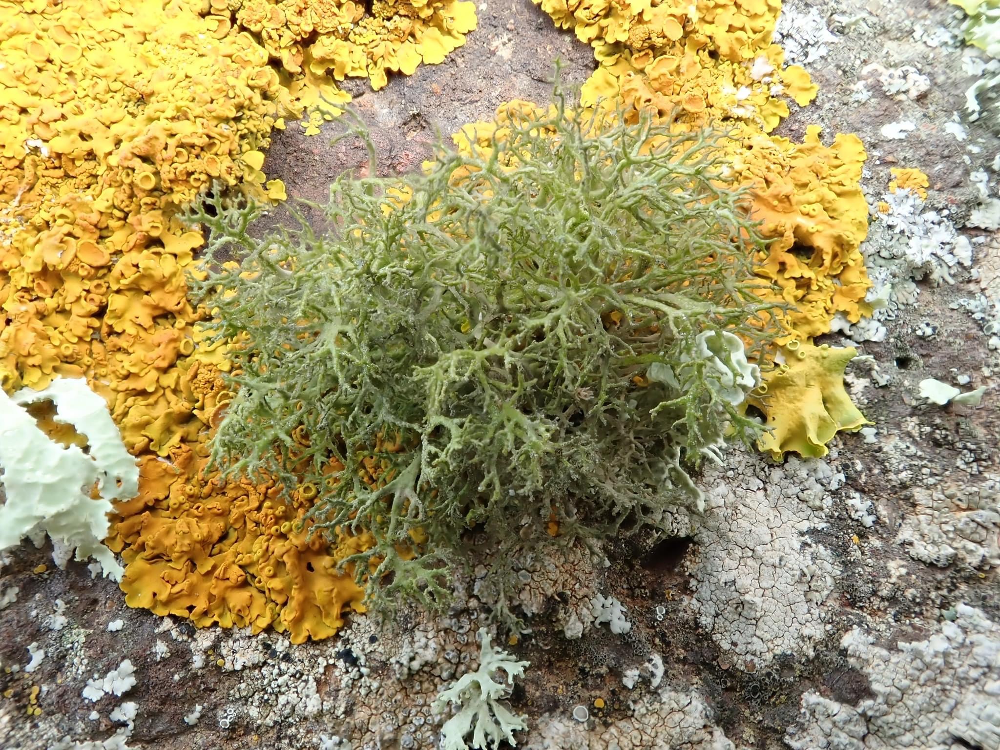
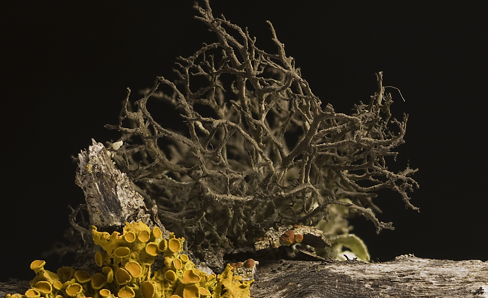
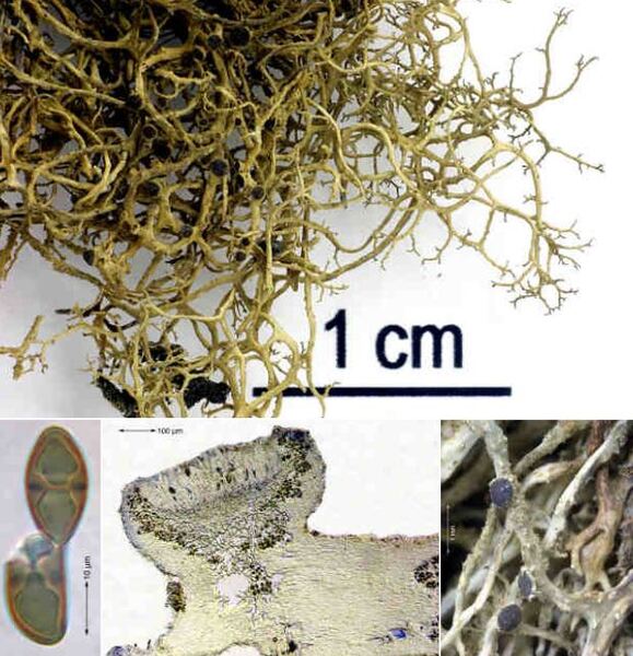
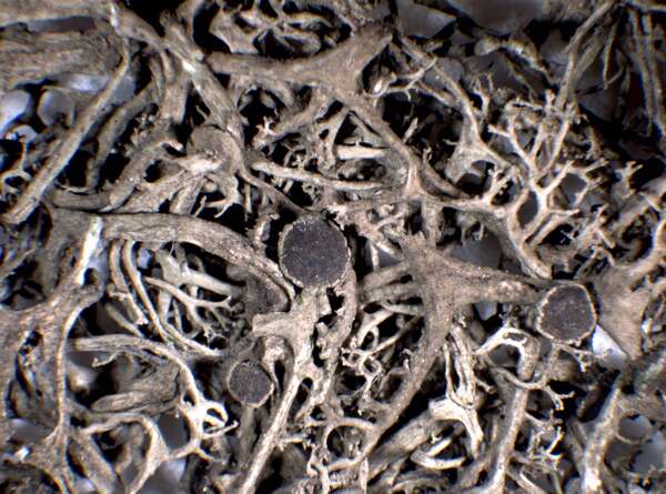
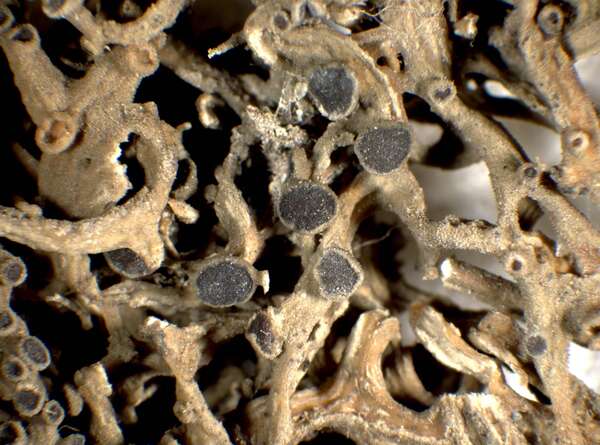
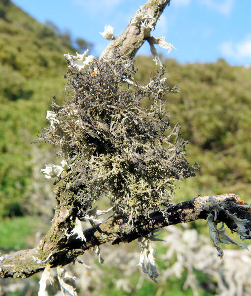
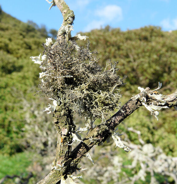
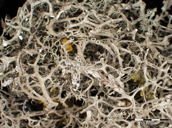
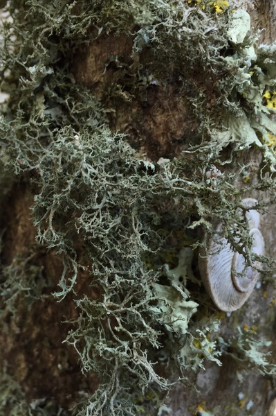
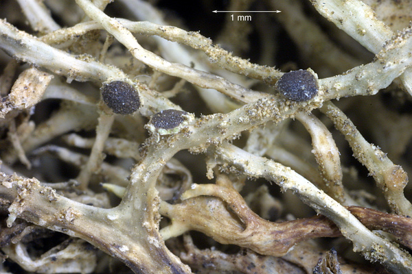
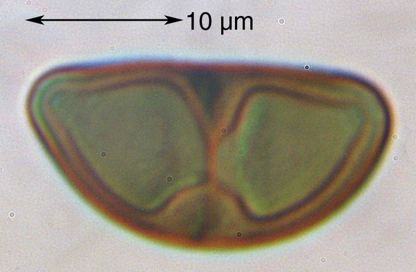
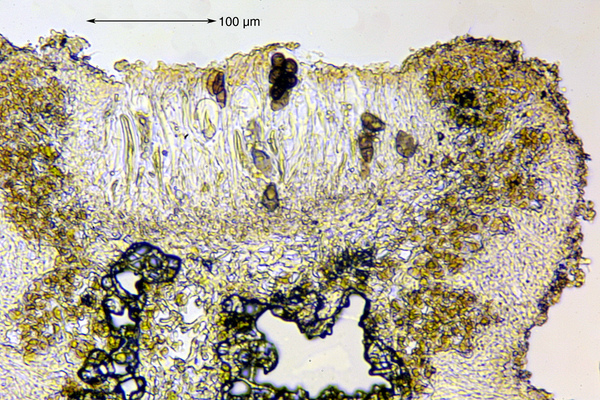
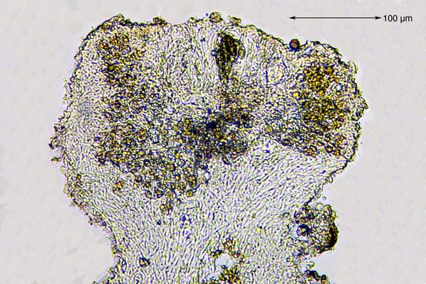
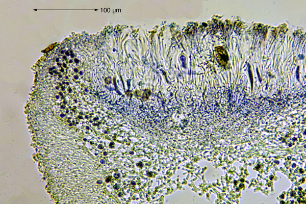
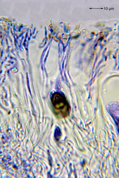
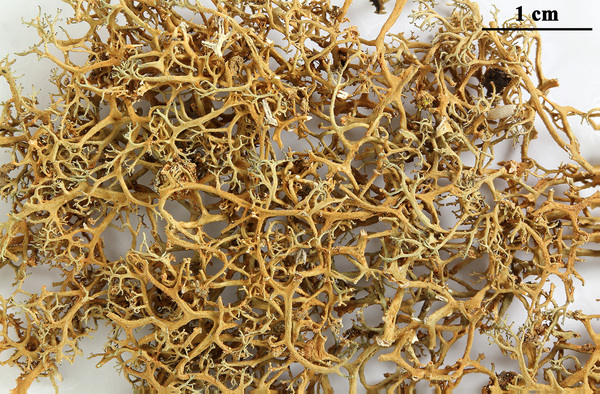
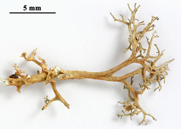
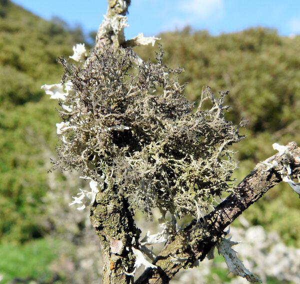
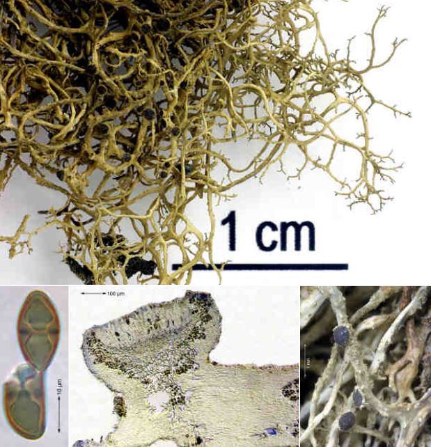
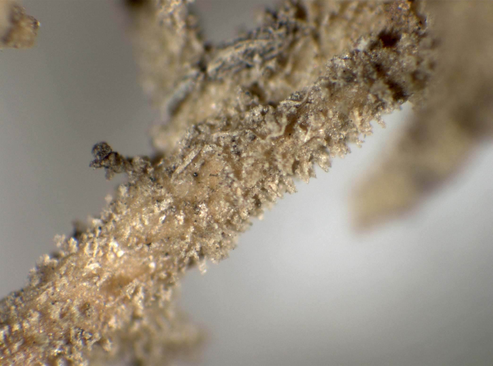
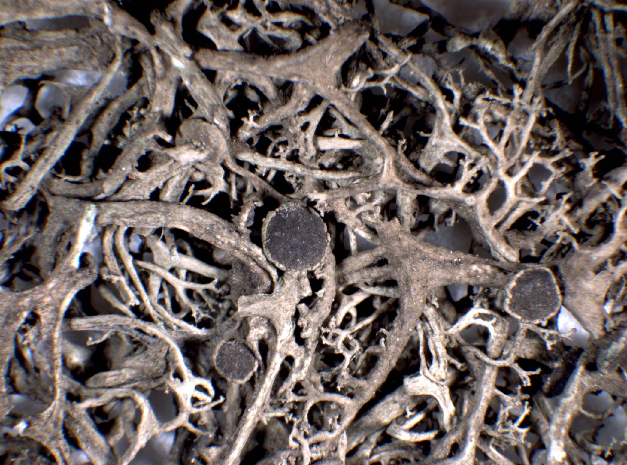
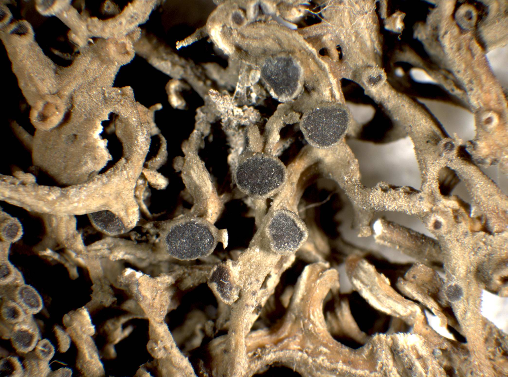
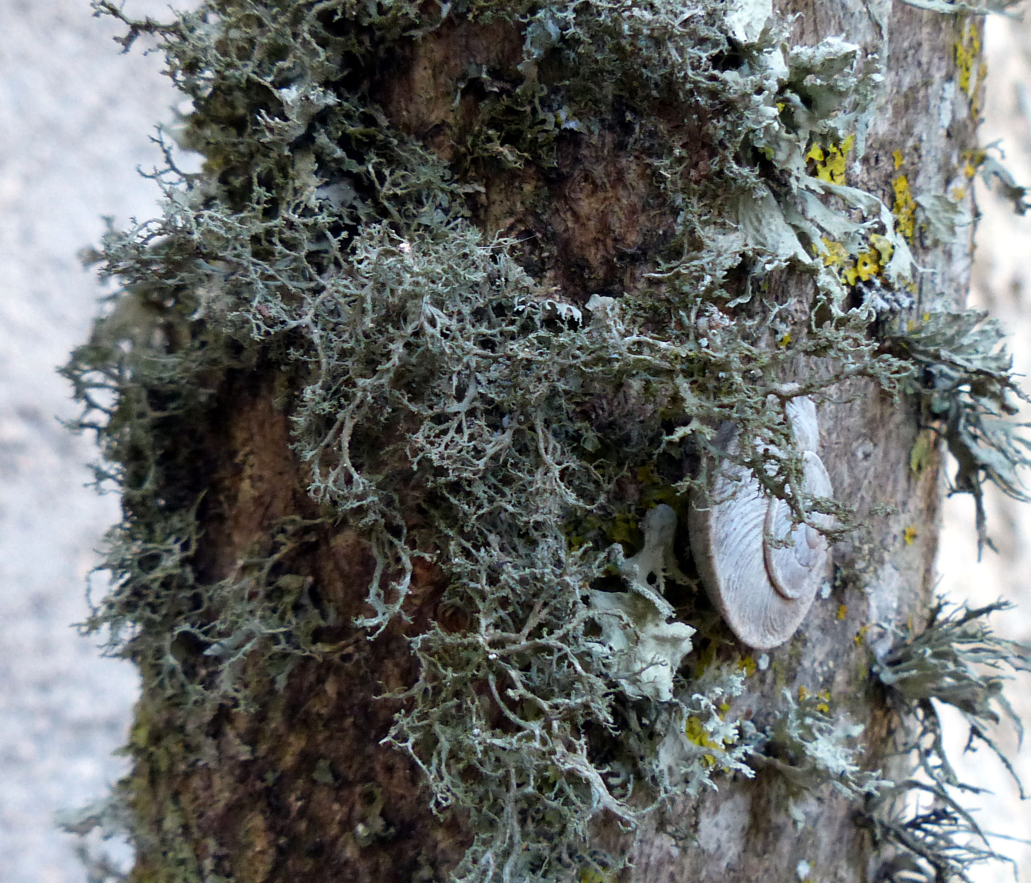
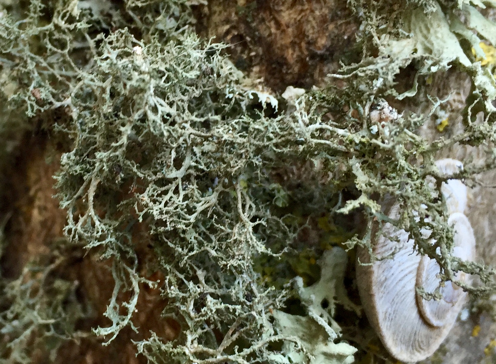
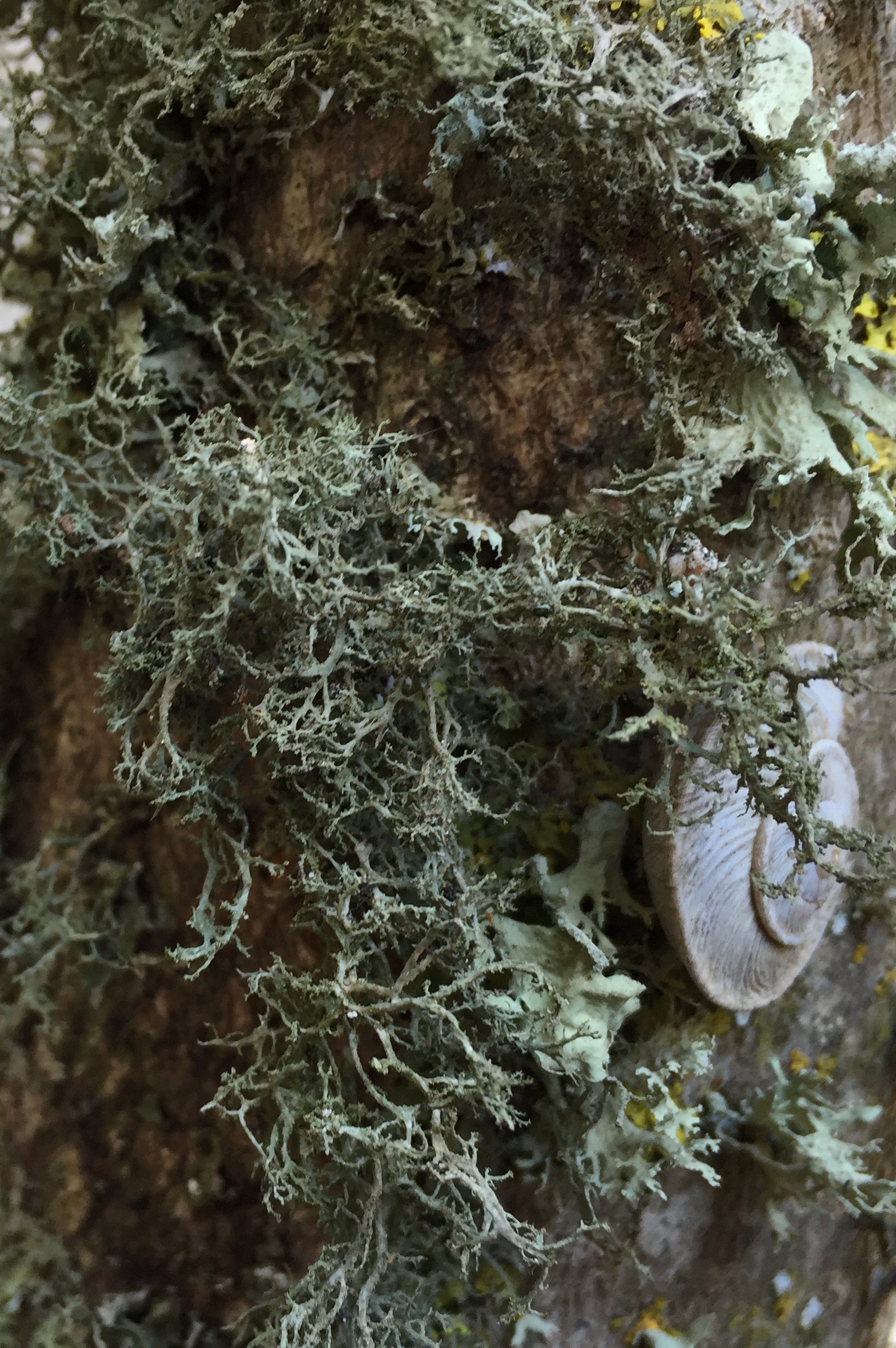
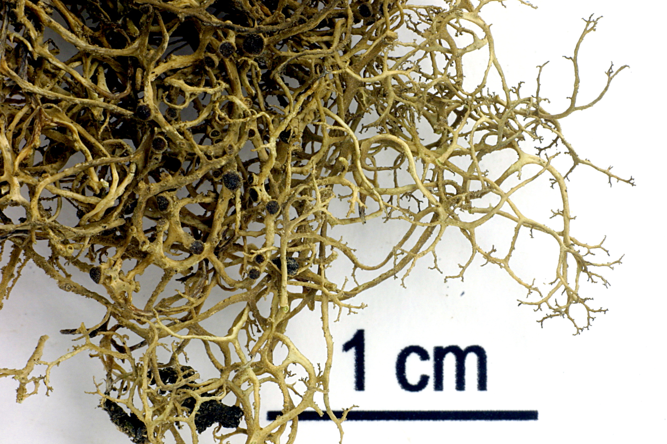
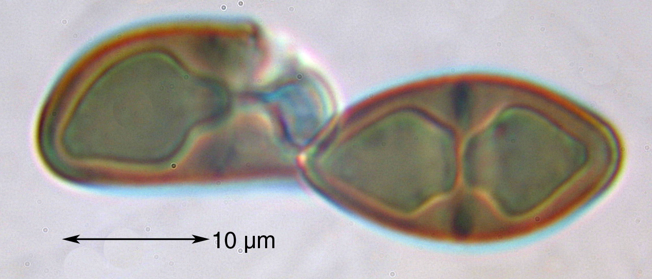
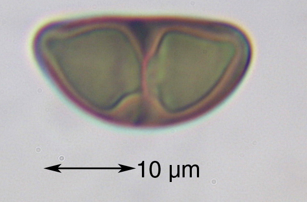
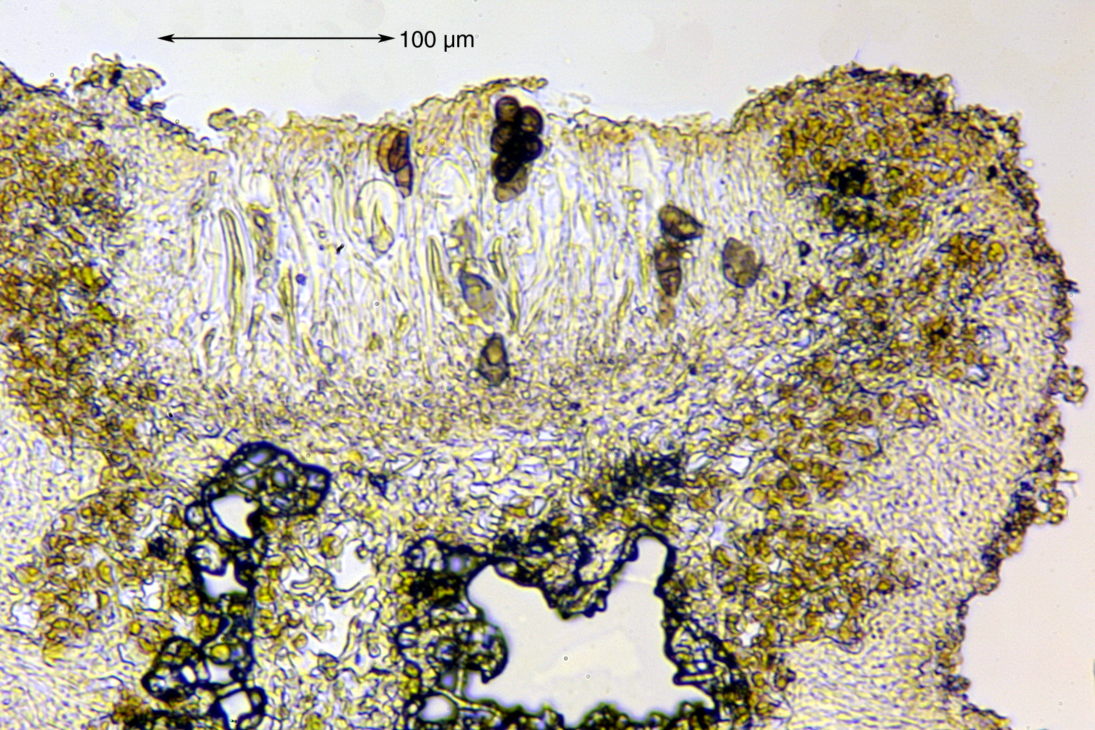
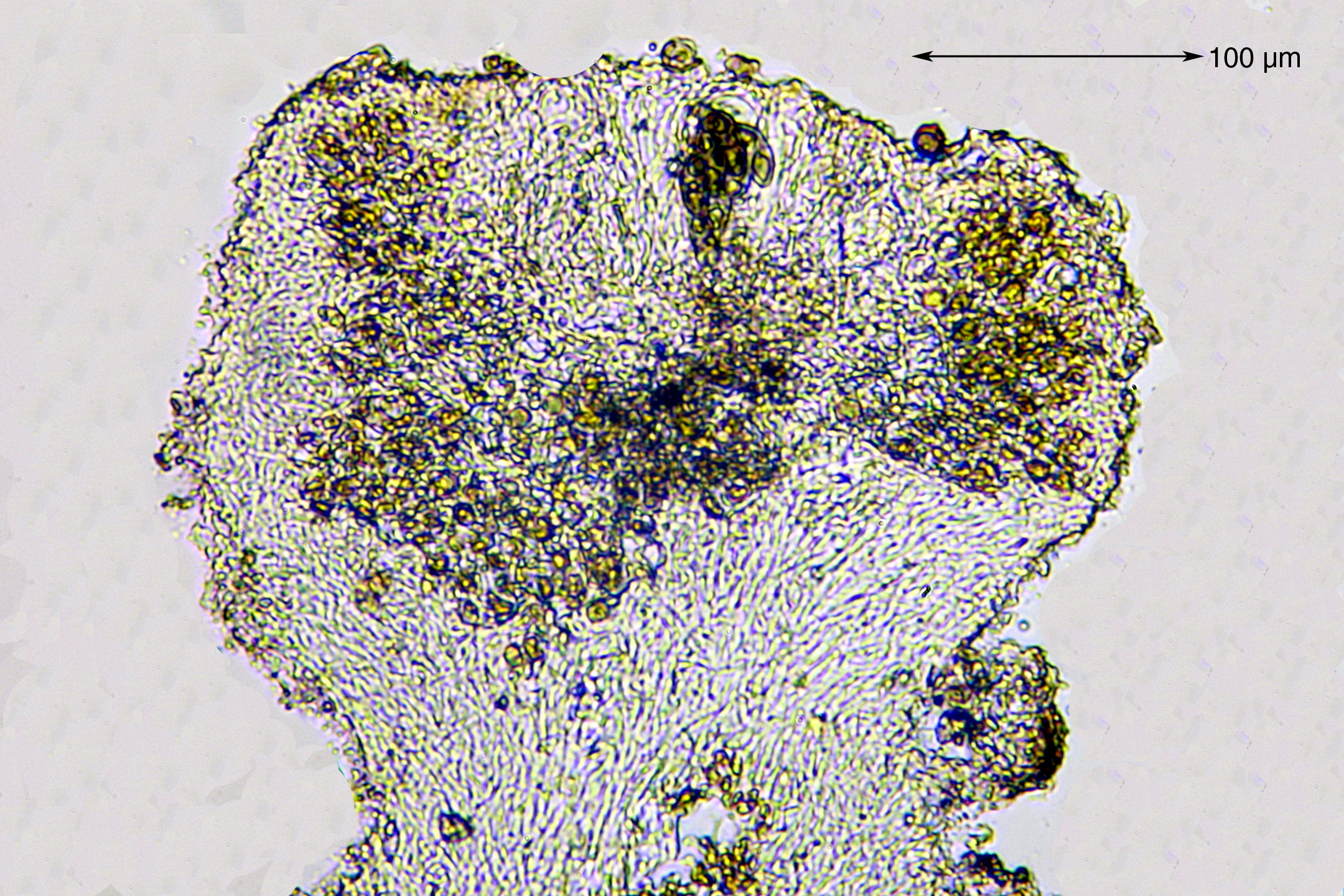
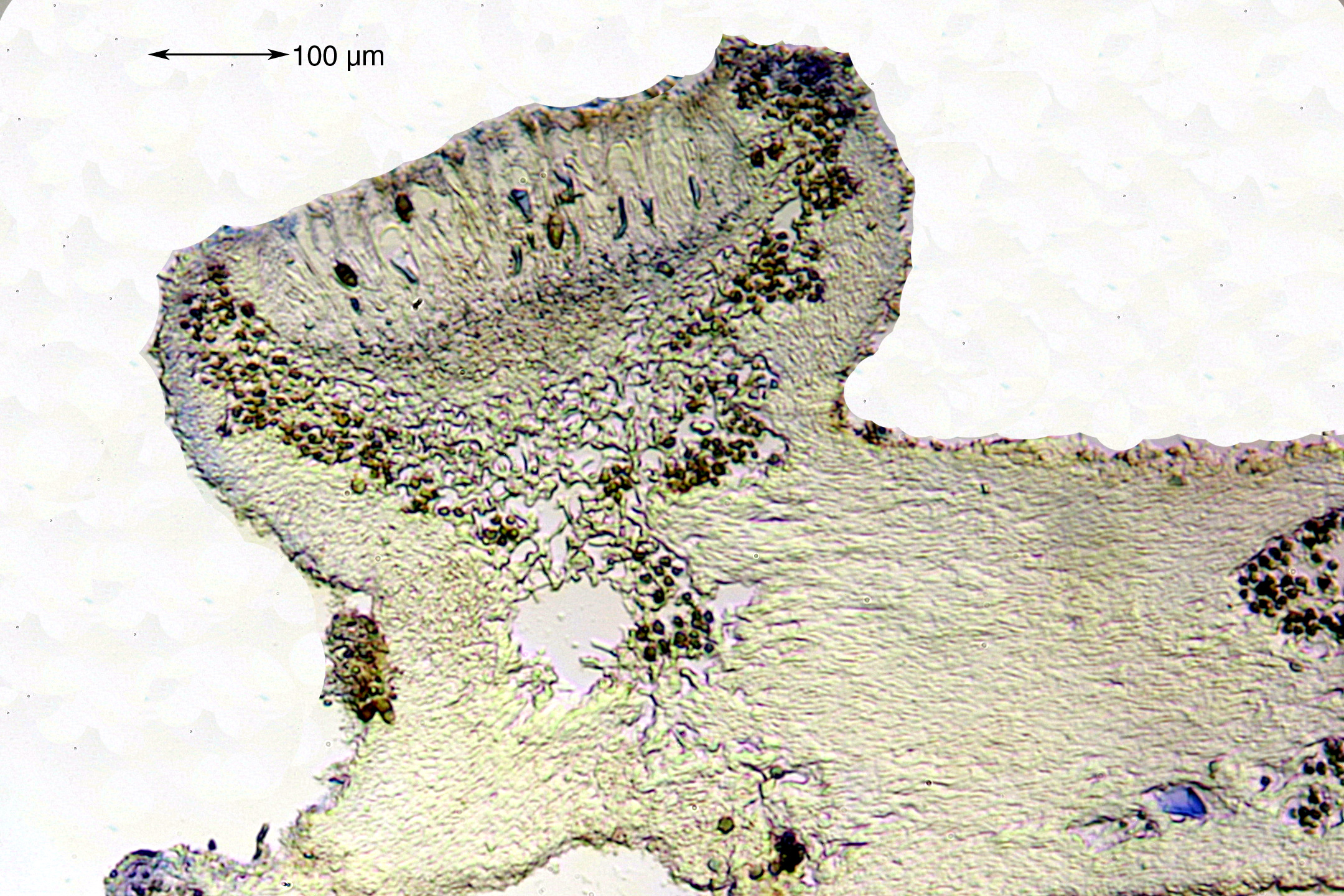
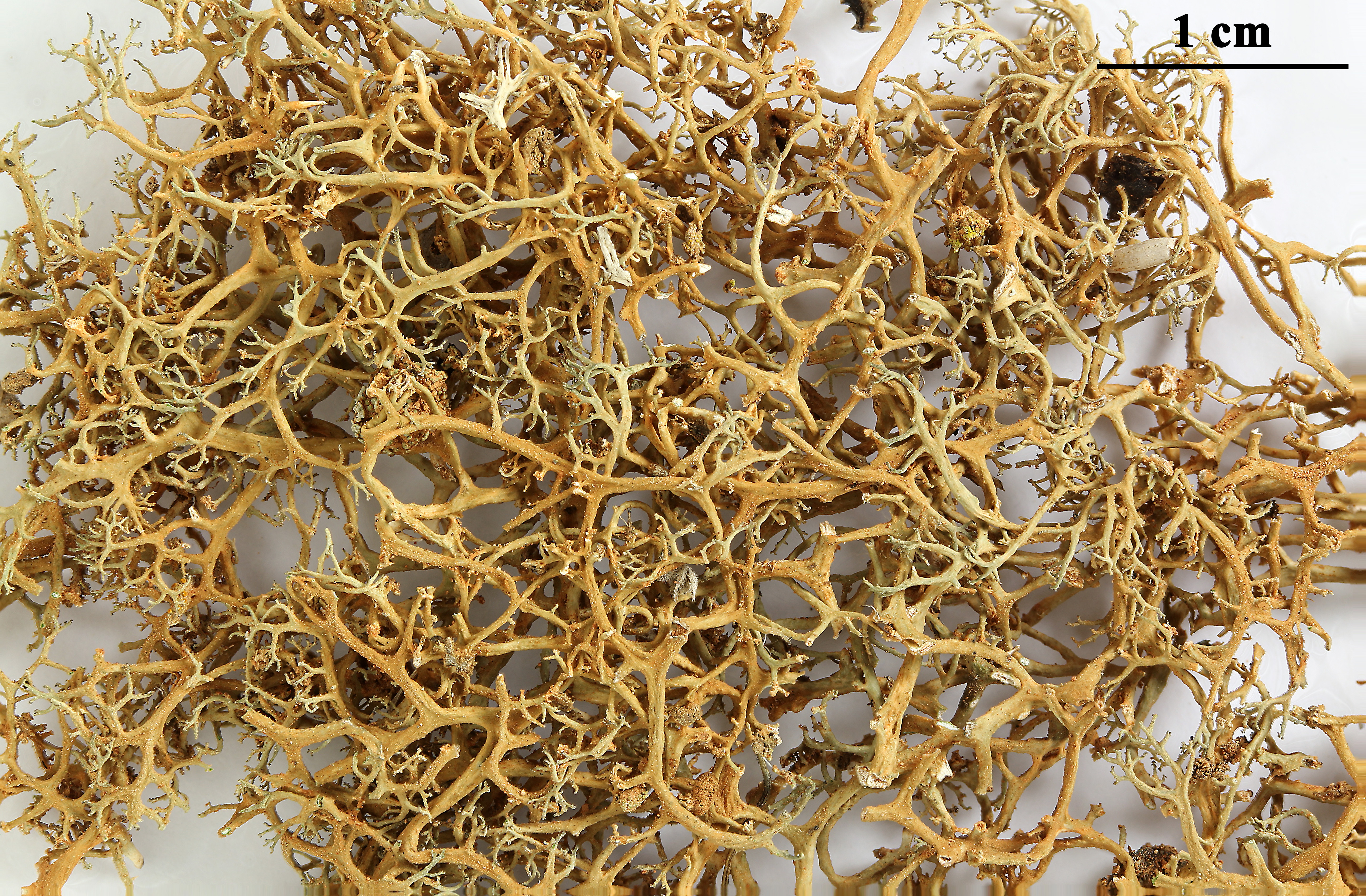
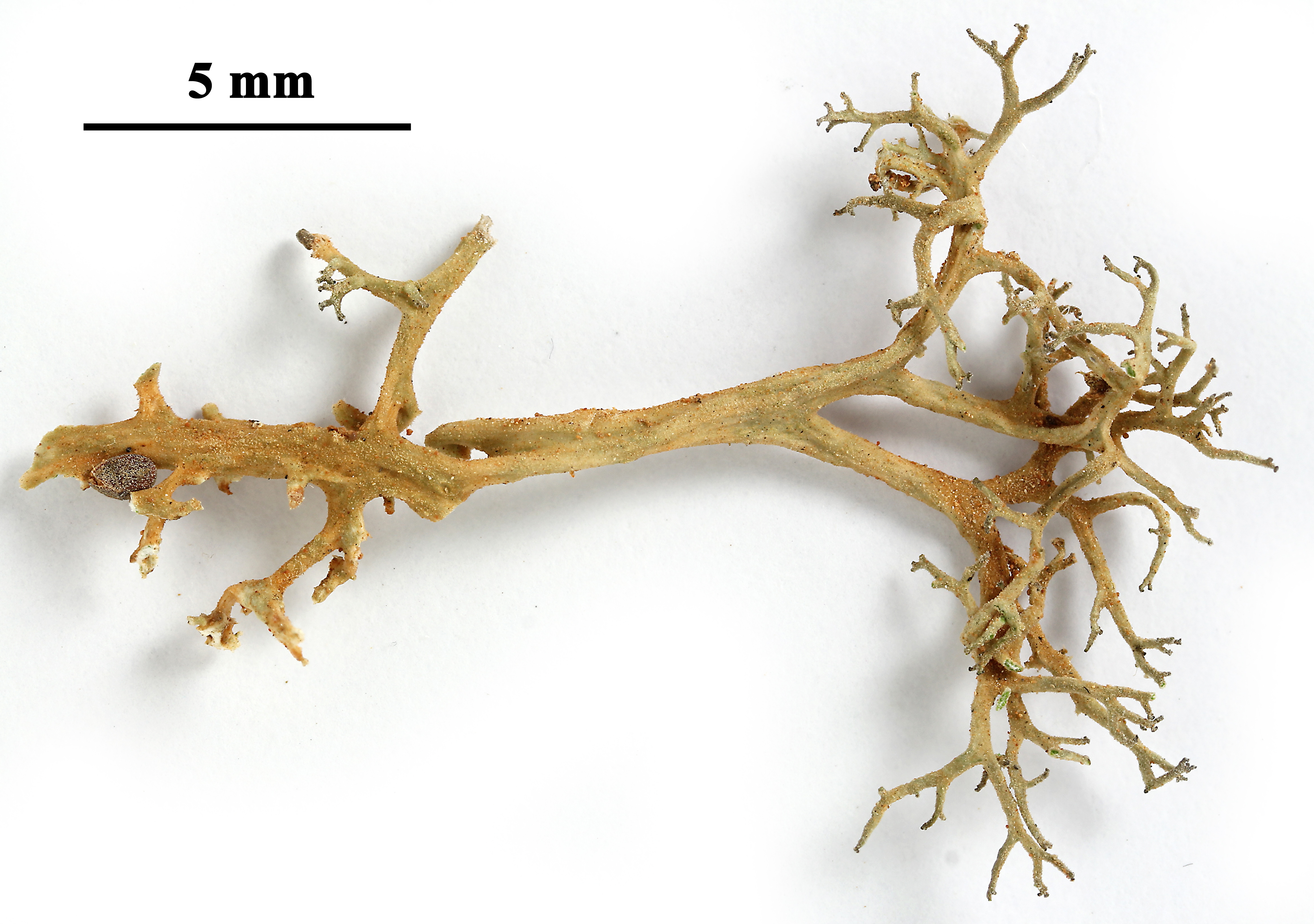
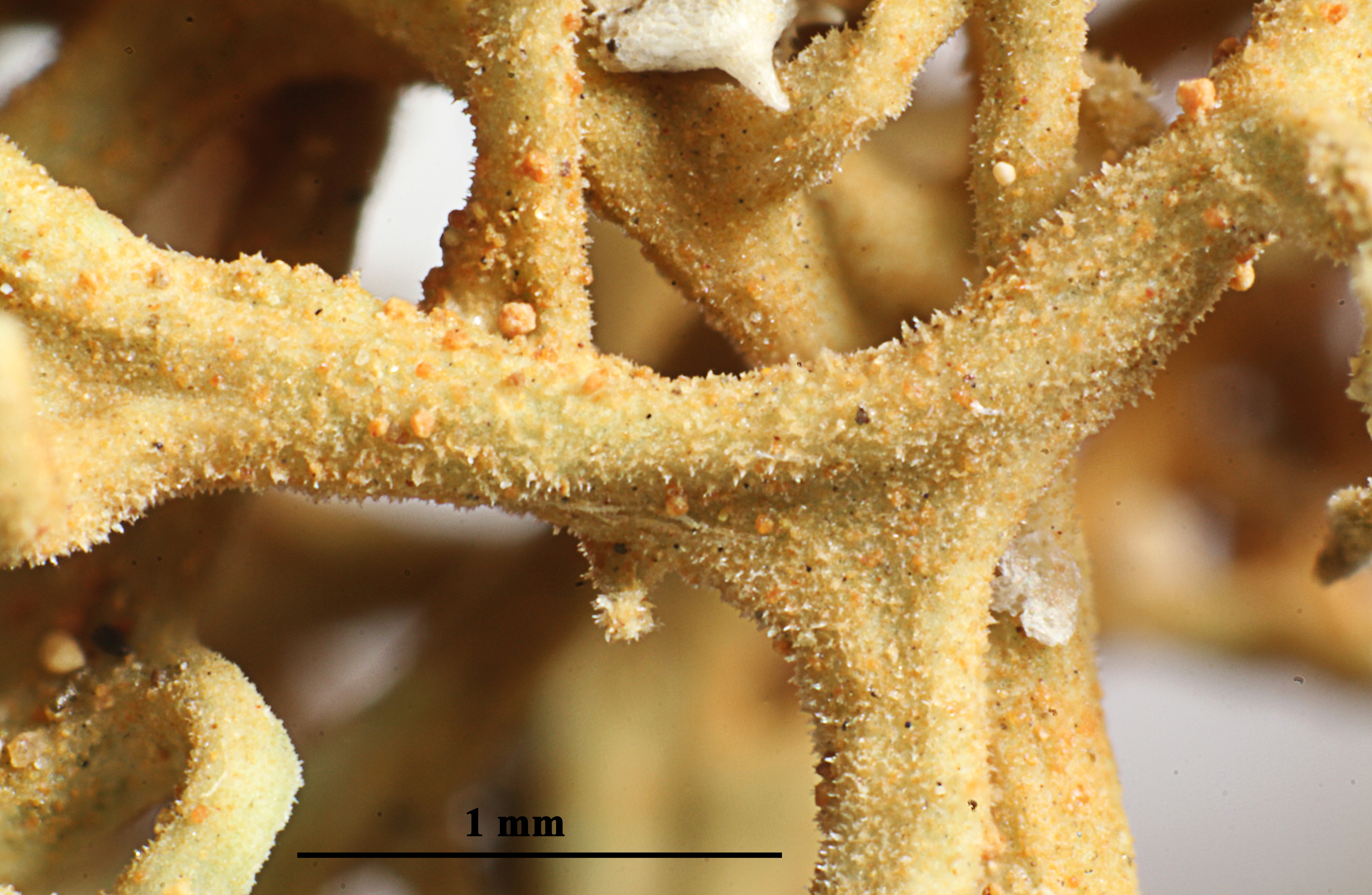
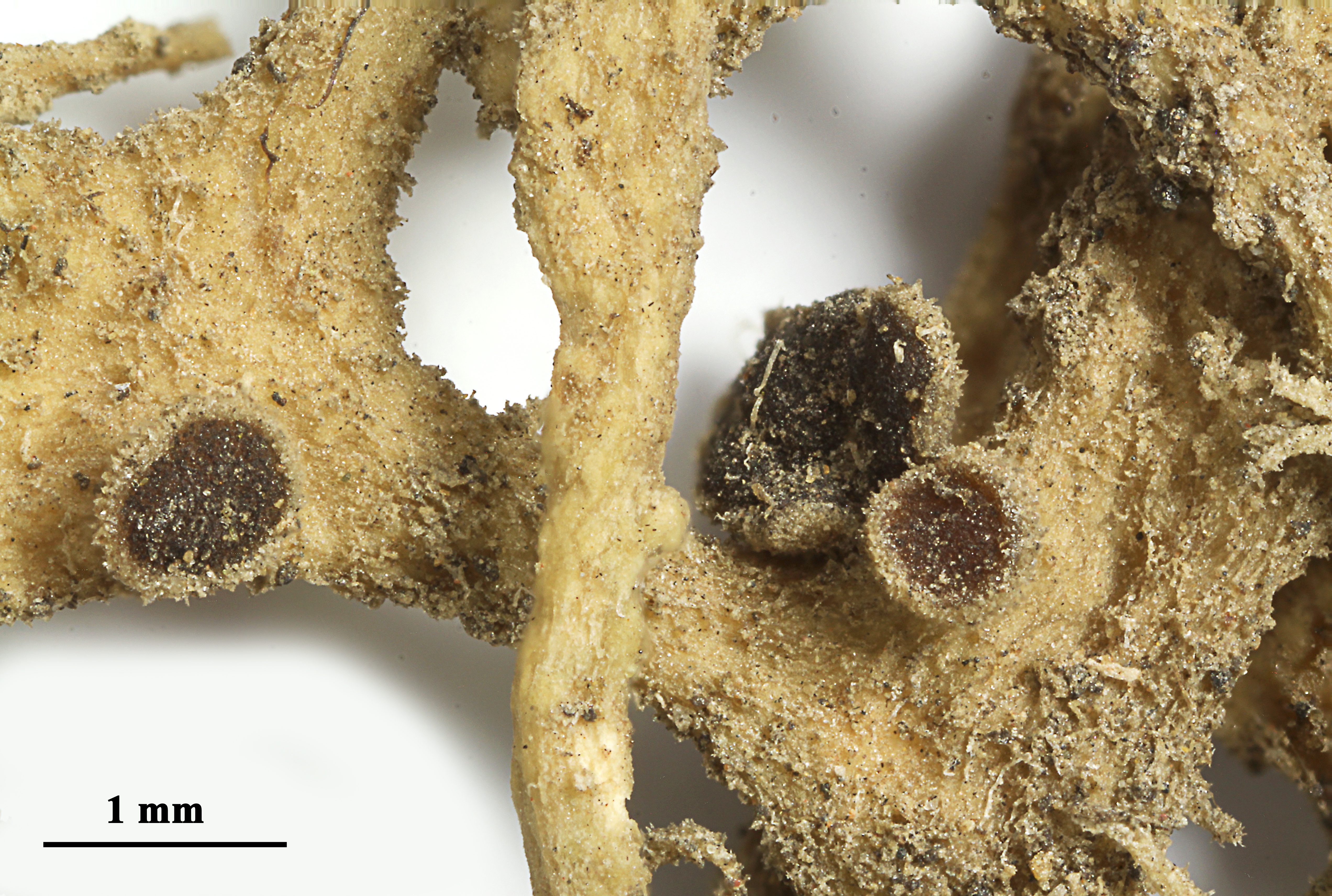
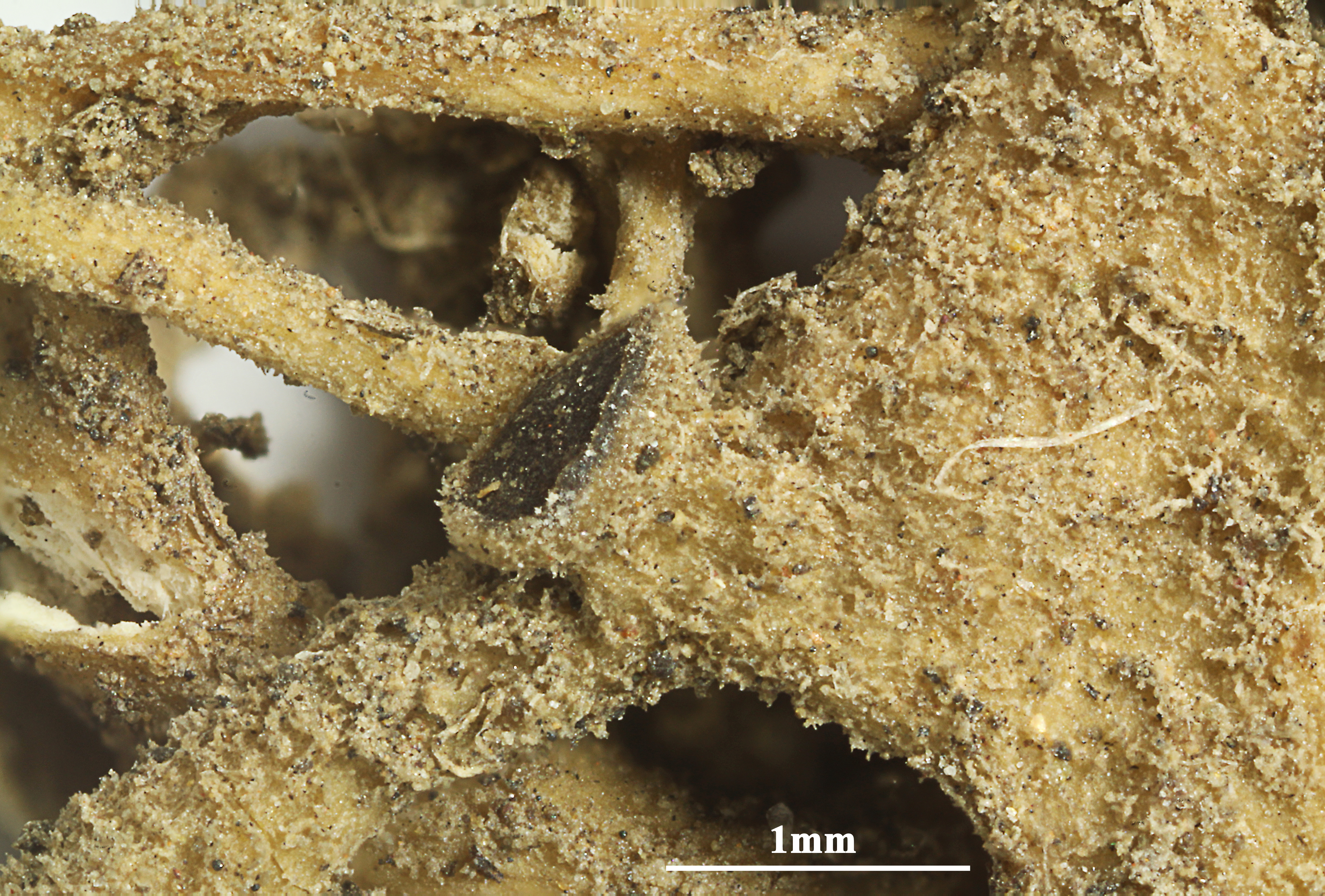
Description: Thallus fruticose, shrubby to subpendent, up to 5 cm long, grey-brown to greenish brown, sparingly to richly branched, the branches to 1.2 mm thick, becoming progressively thinner towards the apices, subterete to flattened (especially in basal parts), densely and finely hairy to totally glabrous, sometimes diffusely blastidiate (especially in sterile specimens) and/or with spiniform papillae. Cortex 60-200 µm thick, of conglutinated, thick-walled, mostly longitudinally oriented hyphae, sometimes with an amorphous layer which gives rise to short lateral hyphae reaching the surface; medulla lax to almost absent, of loosely interwoven hyphae, often with strands of conglutinated, longitudinally oriented hyphae below the cortex. Apothecia lecanorine, most frequent in non-blastidiate specimens, to 1.2 mm across, mostly lateral, with a brown-black to black disc and a smooth thalline margin. Asci 8-spored, clavate, very thin-walled, with a K/I+ blue, tall tholus penetrated by a faintly amyloid apical cushion, the wall K/I-, surrounded by a K/I+ blue outer layer, Lecanora-type. Ascospores 1(-2)-septate, brown, ellipsoid, 20-26(-30) x 10-15 µm, the septum c. 6.5 µm thick, intermediate between the Orcularia and Physconia-types, the wall ornamented. Pycnidia rather common, immersed, with a dark brown ostiolum. Conidia hyaline, fusiform to bacilliform, 3.5-4.5(-5) x c. 1 µm. Photobiont chlorococcoid. Spot tests: cortex and medulla K-, C-, KC-, P-, UV-. Chemistry: without lichen substances.Note: on a wide variety of substrata, most frequent on branches of littoral shrubs but also on rocks, and, but only in a few very warm-humid areas, even on mortar (e.g. it is still abundant in the village of Erice in Sicily); much more widespread in the past, but presently restricted to a few, localised stations with natural vegetation, especially sand dunes, mostly along the Tyrrhenian coast, in sites with a high persistence of fog, or with frequent humid maritime winds alternating with dry periods. It is included in the Italian red list of epiphytic lichens under the “Least Concern” category (Nascimbene & al. 2013c).
Growth form: Fruticose
Substrata: bark and rocks
Photobiont: green algae other than Trentepohlia
Reproductive strategy: mainly asexual, by soredia, or soredia-like structures (e.g. blastidia)
Commonnes-rarity: (info)
Alpine belt: absent
Subalpine belt: absent
Oromediterranean belt: absent
Montane belt: absent
Submediterranean belt: absent
Padanian area: absent
Humid submediterranean belt: absent
Humid mediterranean belt: extremely rare
Dry mediterranean belt: absent
Predictive model
Herbarium samples

Felix Schumm – CC BY-SA 4.0
Image from: F. Schumm (2008) - Flechten Madeiras, der Kanaren und Azoren. Beck, OHG - ISBN: 978-3-00-023700-3
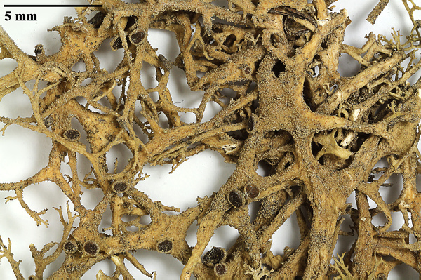
P.L. Nimis; Owner: Department of Life Sciences, University of Trieste
Herbarium: TSB (9951)
2001/11/30
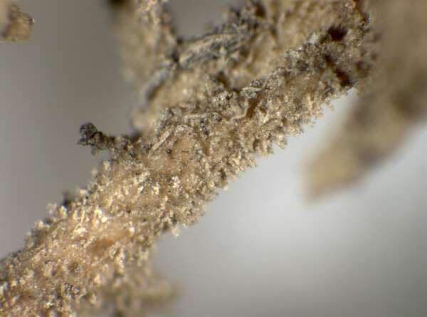
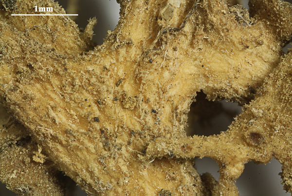
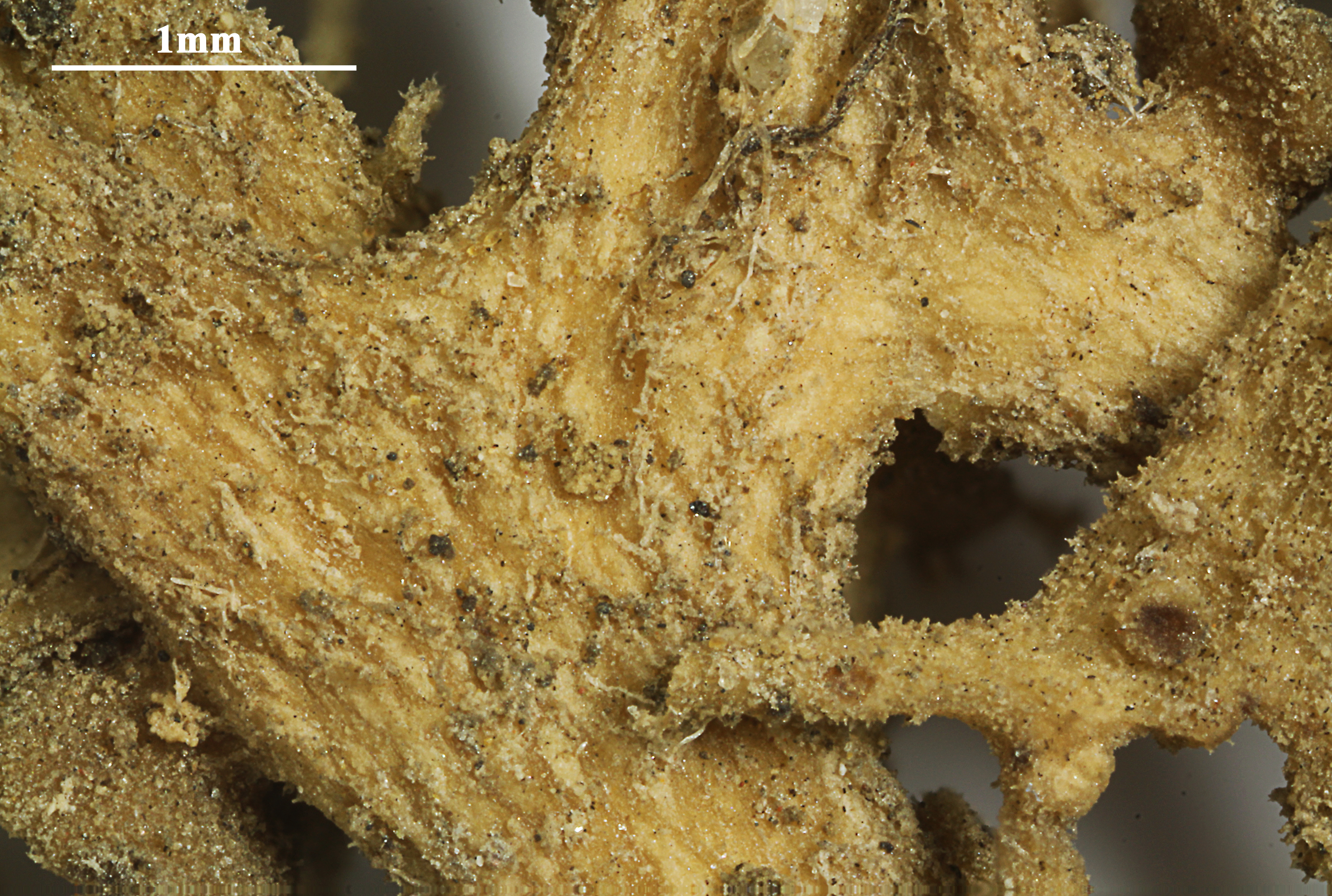
detail of a branch, sterile specimen
P.L. Nimis; Owner: Department of Life Sciences, University of Trieste
Herbarium: TSB (20163)
2001/11/30
P.L. Nimis; Owner: Department of Life Sciences, University of Trieste
Herbarium: TSB (9951)
2001/11/30
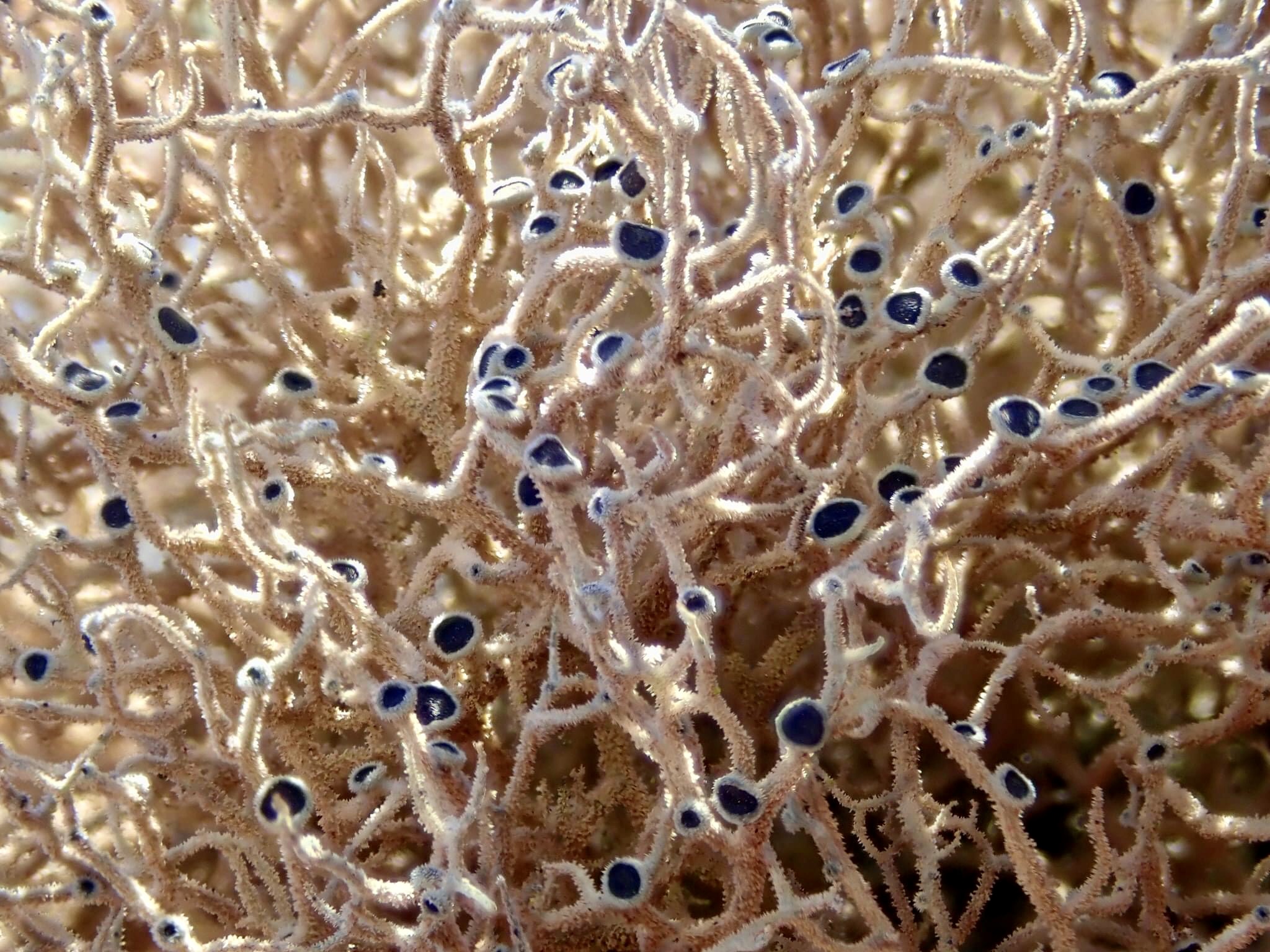
fruiting specimen
A. Moro; Owner: Department of Life Sciences, University of Trieste
Sicilia, TP, Isola di Marettimo
2008.04.03
A. Moro; Owner: Department of Life Sciences, University of Trieste
Sicilia, TP, Isola di Marettimo
2008.04.03
Arsen Gasparyan; Owner: Arsen Gasparyan CC-BY-SA-4.0

Andrea Moro; Owner: Department of Life Sciences, University of Trieste
Italy, Sicily, Trapani, Erice, Historical Center

Pier Luigi Nimis; Owner: Department of Life Sciences, University of Trieste
Italy, Sicily, Trapani, Erice, castle
12/2016
Pier Luigi Nimis; Owner: Department of Life Sciences, University of Trieste
Italy, Sicily, Trapani, Erice, castle
12/2016
Felix Schumm - CC BY-SA 4.0
[9379], Spanien, Kanaren, La Gomera, bei Arure an der Straße nach Las Hayas, trockener Abhang mit Felsblöcken und Euphorbia, 28°07.895 N, 17°18.983 W, 870 m. An alter Euphorbia. Leg. F. Schumm, 14.02.2002, det. F. Schumm 2007

Felix Schumm - CC BY-SA 4.0
[9379], Spanien, Kanaren, La Gomera, bei Arure an der Straße nach Las Hayas, trockener Abhang mit Felsblöcken und Euphorbia, 28°07.895 N, 17°18.983 W, 870 m. An alter Euphorbia. Leg. F. Schumm, 14.02.2002, det. F. Schumm 2007

Felix Schumm - CC BY-SA 4.0
[9379], Spanien, Kanaren, La Gomera, bei Arure an der Straße nach Las Hayas, trockener Abhang mit Felsblöcken und Euphorbia, 28°07.895 N, 17°18.983 W, 870 m. An alter Euphorbia. Leg. F. Schumm, 14.02.2002, det. F. Schumm 2007

Felix Schumm - CC BY-SA 4.0
[9379], Spanien, Kanaren, La Gomera, bei Arure an der Straße nach Las Hayas, trockener Abhang mit Felsblöcken und Euphorbia, 28°07.895 N, 17°18.983 W, 870 m. An alter Euphorbia. Leg. F. Schumm, 14.02.2002, det. F. Schumm 2007
Felix Schumm - CC BY-SA 4.0
[9379], Spanien, Kanaren, La Gomera, bei Arure an der Straße nach Las Hayas, trockener Abhang mit Felsblöcken und Euphorbia, 28°07.895 N, 17°18.983 W, 870 m. An alter Euphorbia. Leg. F. Schumm, 14.02.2002, det. F. Schumm 2007
Felix Schumm - CC BY-SA 4.0
[9379], Spanien, Kanaren, La Gomera, bei Arure an der Straße nach Las Hayas, trockener Abhang mit Felsblöcken und Euphorbia, 28°07.895 N, 17°18.983 W, 870 m. An alter Euphorbia. Leg. F. Schumm, 14.02.2002, det. F. Schumm 2007
Felix Schumm - CC BY-SA 4.0
[9379], Spanien, Kanaren, La Gomera, bei Arure an der Straße nach Las Hayas, trockener Abhang mit Felsblöcken und Euphorbia, 28°07.895 N, 17°18.983 W, 870 m. An alter Euphorbia. Leg. F. Schumm, 14.02.2002, det. F. Schumm 2007

Felix Schumm - CC BY-SA 4.0
[9379], Spanien, Kanaren, La Gomera, bei Arure an der Straße nach Las Hayas, trockener Abhang mit Felsblöcken und Euphorbia, 28°07.895 N, 17°18.983 W, 870 m. An alter Euphorbia. Leg. F. Schumm, 14.02.2002, det. F. Schumm 2007
Felix Schumm - CC BY-SA 4.0
[9379], Spanien, Kanaren, La Gomera, bei Arure an der Straße nach Las Hayas, trockener Abhang mit Felsblöcken und Euphorbia, 28°07.895 N, 17°18.983 W, 870 m. An alter Euphorbia. Leg. F. Schumm, 14.02.2002, det. F. Schumm 2007
Felix Schumm - CC BY-SA 4.0
[9379], Spanien, Kanaren, La Gomera, bei Arure an der Straße nach Las Hayas, trockener Abhang mit Felsblöcken und Euphorbia, 28°07.895 N, 17°18.983 W, 870 m. An alter Euphorbia. Leg. F. Schumm, 14.02.2002, det. F. Schumm 2007
Felix Schumm - CC BY-SA 4.0
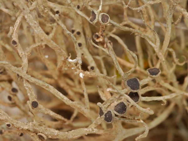
[19748]. Spain, Canary Islands, Lanzarote, Lavafeld bei Teguise am Weg zur Burg Santa Barbara, zwischen und auf Lavablöcken, 29.05868° N, 13.55607° W, 333 m. Leg. F. Schumm & P. Richter, 22.01.2018, det. F. Schumm.
Felix Schumm - CC BY-SA 4.0
[19748]. Spain, Canary Islands, Lanzarote, Lavafeld bei Teguise am Weg zur Burg Santa Barbara, zwischen und auf Lavablöcken, 29.05868° N, 13.55607° W, 333 m. Leg. F. Schumm & P. Richter, 22.01.2018, det. F. Schumm.

Felix Schumm - CC BY-SA 4.0
[19748]. Spain, Canary Islands, Lanzarote, Lavafeld bei Teguise am Weg zur Burg Santa Barbara, zwischen und auf Lavablöcken, 29.05868° N, 13.55607° W, 333 m. Leg. F. Schumm & P. Richter, 22.01.2018, det. F. Schumm.

Felix Schumm - CC BY-SA 4.0
[19748]. Spain, Canary Islands, Lanzarote, Lavafeld bei Teguise am Weg zur Burg Santa Barbara, zwischen und auf Lavablöcken, 29.05868° N, 13.55607° W, 333 m. Leg. F. Schumm & P. Richter, 22.01.2018, det. F. Schumm.
A. Moro; Owner: Department of Life Sciences, University of Trieste
Sicilia, TP, Isola di Marettimo
2008.04.03
Leif Stridvall
Courtesy: Anita Stridvall -Source: http://www.stridvall.se/lichens/gallery/

Leif Stridvall
Courtesy: Anita Stridvall -Source: http://www.stridvall.se/lichens/gallery/
Leif Stridvall
Courtesy: Anita Stridvall -Source: http://www.stridvall.se/lichens/gallery/
Felix Schumm - CC BY-SA4.0
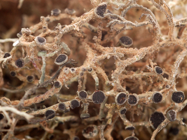
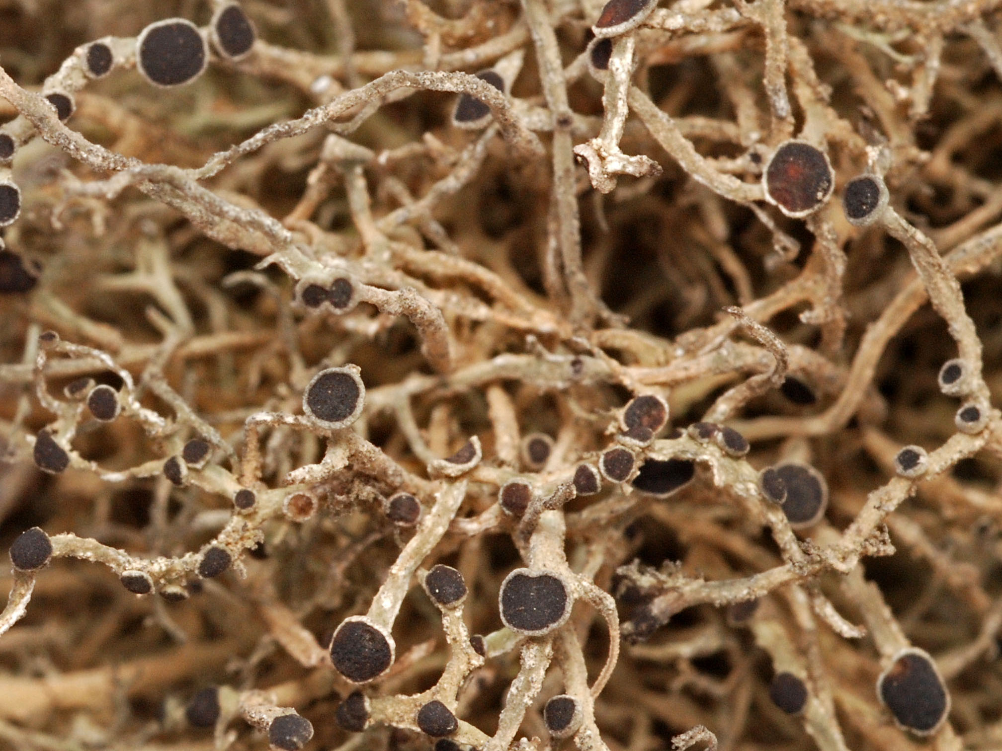
[20868], Italy, Lazio, prov. Roma, 26 km SSW of the centre of Rom, 9.4 km W of the centre of Pomezia, Tenuta di Caccia di Castel Porziano, 41°49'43''N, 12°23'17'' E, 5 m, macchia vegetation, close to the beach, on twiga of unnamed shrubs in a low macchia stand. Leg. H. Mayrhofer (no 21842) & J. Poelt, 8.5.1986, det. H. Mayrhofer. LICHENOTHECA GRAECENSIS NO. 499

Felix Schumm - CC BY-SA4.0
[20868], Italy, Lazio, prov. Roma, 26 km SSW of the centre of Rom, 9.4 km W of the centre of Pomezia, Tenuta di Caccia di Castel Porziano, 41°49'43''N, 12°23'17'' E, 5 m, macchia vegetation, close to the beach, on twiga of unnamed shrubs in a low macchia stand. Leg. H. Mayrhofer (no 21842) & J. Poelt, 8.5.1986, det. H. Mayrhofer. LICHENOTHECA GRAECENSIS NO. 499

Manuel Gil
Spain, Canary Islands, Lanzarote, El Bosquecillo

Manuel Gil
Spain, Canary Islands, Lanzarote, Las Nieves
Growth form: Fruticose
Substrata: bark and rocks
Photobiont: green algae other than Trentepohlia
Reproductive strategy: mainly asexual, by soredia, or soredia-like structures (e.g. blastidia)
Commonnes-rarity: (info)
Alpine belt: absent
Subalpine belt: absent
Oromediterranean belt: absent
Montane belt: absent
Submediterranean belt: absent
Padanian area: absent
Humid submediterranean belt: absent
Humid mediterranean belt: extremely rare
Dry mediterranean belt: absent
Predictive model
| Herbarium samples |
Felix Schumm – CC BY-SA 4.0
Image from: F. Schumm (2008) - Flechten Madeiras, der Kanaren und Azoren. Beck, OHG - ISBN: 978-3-00-023700-3
P.L. Nimis; Owner: Department of Life Sciences, University of Trieste
Herbarium: TSB (9951)
2001/11/30
detail of a branch, sterile specimen
P.L. Nimis; Owner: Department of Life Sciences, University of Trieste
Herbarium: TSB (20163)
2001/11/30
P.L. Nimis; Owner: Department of Life Sciences, University of Trieste
Herbarium: TSB (9951)
2001/11/30
fruiting specimen

A. Moro; Owner: Department of Life Sciences, University of Trieste
Sicilia, TP, Isola di Marettimo
2008.04.03

A. Moro; Owner: Department of Life Sciences, University of Trieste
Sicilia, TP, Isola di Marettimo
2008.04.03

Arsen Gasparyan; Owner: Arsen Gasparyan CC-BY-SA-4.0
Andrea Moro; Owner: Department of Life Sciences, University of Trieste
Italy, Sicily, Trapani, Erice, Historical Center
Pier Luigi Nimis; Owner: Department of Life Sciences, University of Trieste
Italy, Sicily, Trapani, Erice, castle
12/2016
Pier Luigi Nimis; Owner: Department of Life Sciences, University of Trieste
Italy, Sicily, Trapani, Erice, castle
12/2016

Felix Schumm - CC BY-SA 4.0
[9379], Spanien, Kanaren, La Gomera, bei Arure an der Straße nach Las Hayas, trockener Abhang mit Felsblöcken und Euphorbia, 28°07.895 N, 17°18.983 W, 870 m. An alter Euphorbia. Leg. F. Schumm, 14.02.2002, det. F. Schumm 2007
Felix Schumm - CC BY-SA 4.0
[9379], Spanien, Kanaren, La Gomera, bei Arure an der Straße nach Las Hayas, trockener Abhang mit Felsblöcken und Euphorbia, 28°07.895 N, 17°18.983 W, 870 m. An alter Euphorbia. Leg. F. Schumm, 14.02.2002, det. F. Schumm 2007
Felix Schumm - CC BY-SA 4.0
[9379], Spanien, Kanaren, La Gomera, bei Arure an der Straße nach Las Hayas, trockener Abhang mit Felsblöcken und Euphorbia, 28°07.895 N, 17°18.983 W, 870 m. An alter Euphorbia. Leg. F. Schumm, 14.02.2002, det. F. Schumm 2007
Felix Schumm - CC BY-SA 4.0
[9379], Spanien, Kanaren, La Gomera, bei Arure an der Straße nach Las Hayas, trockener Abhang mit Felsblöcken und Euphorbia, 28°07.895 N, 17°18.983 W, 870 m. An alter Euphorbia. Leg. F. Schumm, 14.02.2002, det. F. Schumm 2007

Felix Schumm - CC BY-SA 4.0
[9379], Spanien, Kanaren, La Gomera, bei Arure an der Straße nach Las Hayas, trockener Abhang mit Felsblöcken und Euphorbia, 28°07.895 N, 17°18.983 W, 870 m. An alter Euphorbia. Leg. F. Schumm, 14.02.2002, det. F. Schumm 2007
Felix Schumm - CC BY-SA 4.0
[9379], Spanien, Kanaren, La Gomera, bei Arure an der Straße nach Las Hayas, trockener Abhang mit Felsblöcken und Euphorbia, 28°07.895 N, 17°18.983 W, 870 m. An alter Euphorbia. Leg. F. Schumm, 14.02.2002, det. F. Schumm 2007
Felix Schumm - CC BY-SA 4.0
[9379], Spanien, Kanaren, La Gomera, bei Arure an der Straße nach Las Hayas, trockener Abhang mit Felsblöcken und Euphorbia, 28°07.895 N, 17°18.983 W, 870 m. An alter Euphorbia. Leg. F. Schumm, 14.02.2002, det. F. Schumm 2007
Felix Schumm - CC BY-SA 4.0
[9379], Spanien, Kanaren, La Gomera, bei Arure an der Straße nach Las Hayas, trockener Abhang mit Felsblöcken und Euphorbia, 28°07.895 N, 17°18.983 W, 870 m. An alter Euphorbia. Leg. F. Schumm, 14.02.2002, det. F. Schumm 2007

Felix Schumm - CC BY-SA 4.0
[9379], Spanien, Kanaren, La Gomera, bei Arure an der Straße nach Las Hayas, trockener Abhang mit Felsblöcken und Euphorbia, 28°07.895 N, 17°18.983 W, 870 m. An alter Euphorbia. Leg. F. Schumm, 14.02.2002, det. F. Schumm 2007

Felix Schumm - CC BY-SA 4.0
[9379], Spanien, Kanaren, La Gomera, bei Arure an der Straße nach Las Hayas, trockener Abhang mit Felsblöcken und Euphorbia, 28°07.895 N, 17°18.983 W, 870 m. An alter Euphorbia. Leg. F. Schumm, 14.02.2002, det. F. Schumm 2007
Felix Schumm - CC BY-SA 4.0
[19748]. Spain, Canary Islands, Lanzarote, Lavafeld bei Teguise am Weg zur Burg Santa Barbara, zwischen und auf Lavablöcken, 29.05868° N, 13.55607° W, 333 m. Leg. F. Schumm & P. Richter, 22.01.2018, det. F. Schumm.

Felix Schumm - CC BY-SA 4.0
[19748]. Spain, Canary Islands, Lanzarote, Lavafeld bei Teguise am Weg zur Burg Santa Barbara, zwischen und auf Lavablöcken, 29.05868° N, 13.55607° W, 333 m. Leg. F. Schumm & P. Richter, 22.01.2018, det. F. Schumm.
Felix Schumm - CC BY-SA 4.0
[19748]. Spain, Canary Islands, Lanzarote, Lavafeld bei Teguise am Weg zur Burg Santa Barbara, zwischen und auf Lavablöcken, 29.05868° N, 13.55607° W, 333 m. Leg. F. Schumm & P. Richter, 22.01.2018, det. F. Schumm.
Felix Schumm - CC BY-SA 4.0
[19748]. Spain, Canary Islands, Lanzarote, Lavafeld bei Teguise am Weg zur Burg Santa Barbara, zwischen und auf Lavablöcken, 29.05868° N, 13.55607° W, 333 m. Leg. F. Schumm & P. Richter, 22.01.2018, det. F. Schumm.

A. Moro; Owner: Department of Life Sciences, University of Trieste
Sicilia, TP, Isola di Marettimo
2008.04.03
Leif Stridvall
Courtesy: Anita Stridvall -Source: http://www.stridvall.se/lichens/gallery/
Leif Stridvall
Courtesy: Anita Stridvall -Source: http://www.stridvall.se/lichens/gallery/

Leif Stridvall
Courtesy: Anita Stridvall -Source: http://www.stridvall.se/lichens/gallery/

Felix Schumm - CC BY-SA4.0
[20868], Italy, Lazio, prov. Roma, 26 km SSW of the centre of Rom, 9.4 km W of the centre of Pomezia, Tenuta di Caccia di Castel Porziano, 41°49'43''N, 12°23'17'' E, 5 m, macchia vegetation, close to the beach, on twiga of unnamed shrubs in a low macchia stand. Leg. H. Mayrhofer (no 21842) & J. Poelt, 8.5.1986, det. H. Mayrhofer. LICHENOTHECA GRAECENSIS NO. 499
Manuel Gil
Spain, Canary Islands, Lanzarote, El Bosquecillo