Calicium abietinum Pers.
Tent. Disp. Meth. Fung., Suppl.: 59, 1797.
Synonyms: Calicium abietinum var. crustiferum Vain.; Calicium abietinum var. fuscipes (Nyl.) Zahlbr.; Calicium curtum Turner & Borrer ex Sm.; Calicium minutum Körb.; Calicium nigrum auct. p.p.
Distribution: N - Ven (Nascimbene 2008c, Puntillo & Puntillo 2009, Nascimbene & Marini 2010, Nascimbene & al. 2012), TAA (Nascimbene & al. 2006e, 2007b, 2022, Puntillo & Puntillo 2009, Nascimbene 2014, Nimis & al. 2015), Lomb (Puntillo & Puntillo 2009), Piem (Isocrono & al. 2004, Puntillo & Puntillo 2009), Emil (Puntillo & Puntillo 2009, Brunialti & al. 2001, Fariselli & al. 2020), Lig (Giordani & Incerti 2008, Puntillo & Puntillo 2009). C - Tosc (Puntillo & Puntillo 2009, Benesperi 2011), Marc (Nimis & Tretiach 1999, Puntillo & Puntillo 2009), Laz (Puntillo & Puntillo 2009), Abr (Nimis & Tretiach 1999, Stofer 2006, Puntillo & Puntillo 2009), Mol (Herb. Ravera 4802), Sar (Puntillo & Puntillo 2009, Rizzi & al. 2011, Di Nuzzo & al. 2022). S - Bas (Puntillo & Puntillo 2009, Puntillo & al. 2012), Camp (Puntillo & Puntillo 2009, Catalano & al. 2010, 2016, Garofalo & al. 2010), Pugl (Puntillo & Puntillo 2009), Cal (Puntillo 1994, 1996, Puntillo & Puntillo 2009).
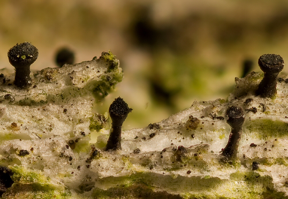
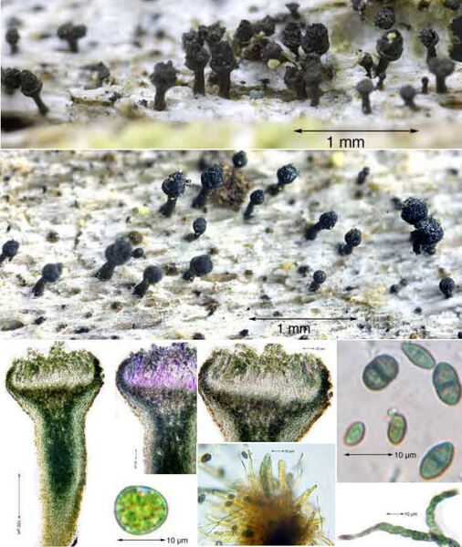
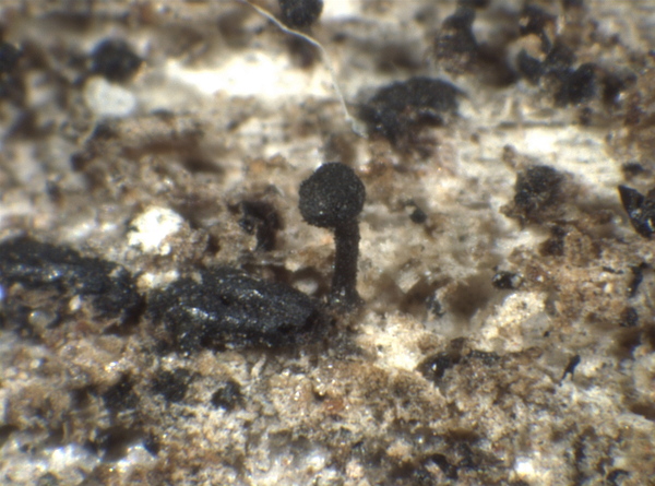
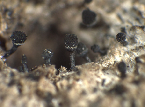
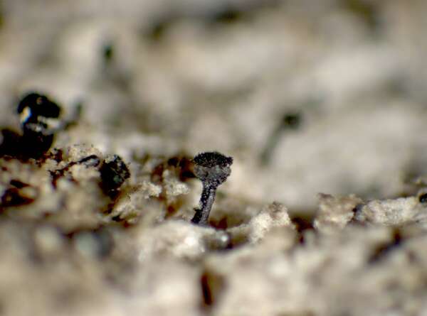
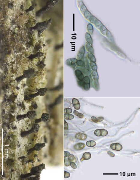
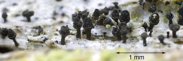
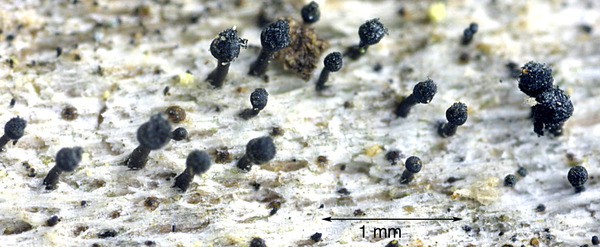
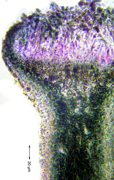
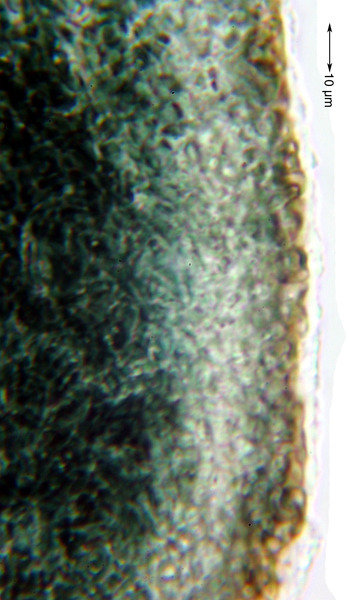
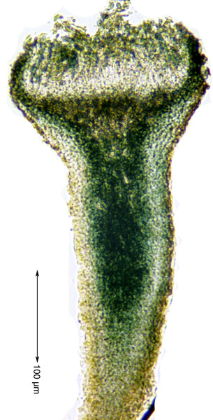
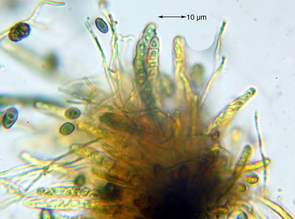
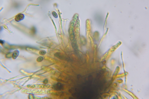
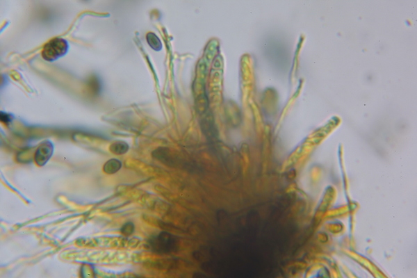
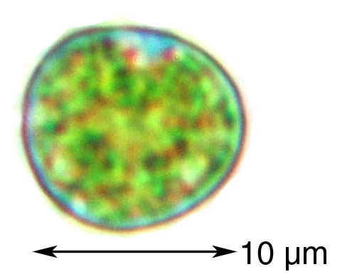
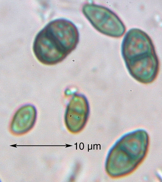
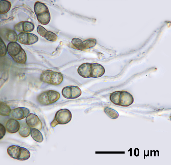
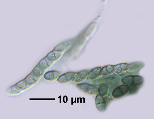
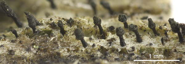
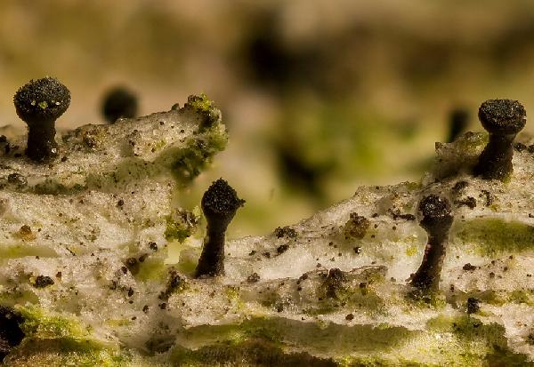
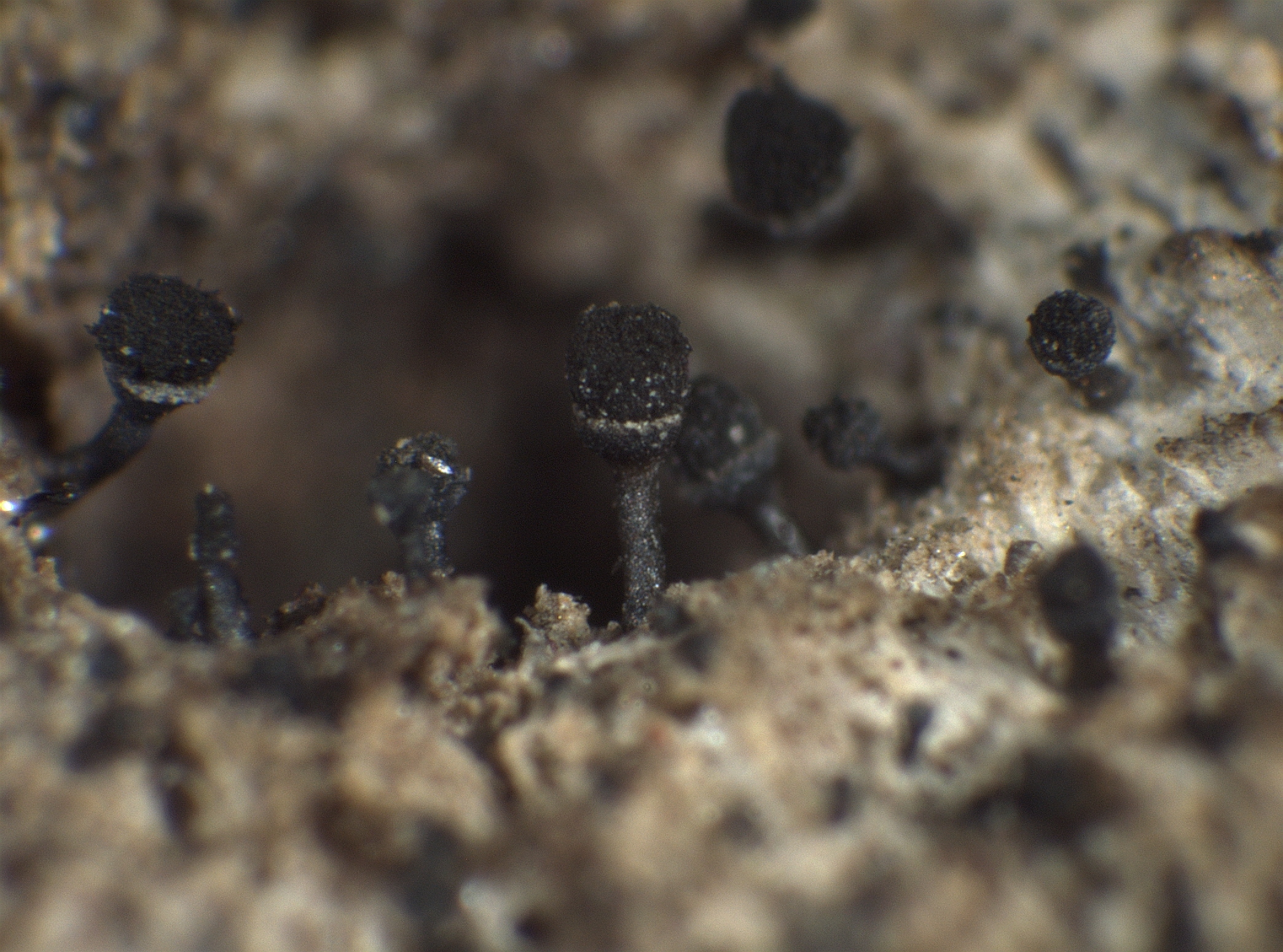
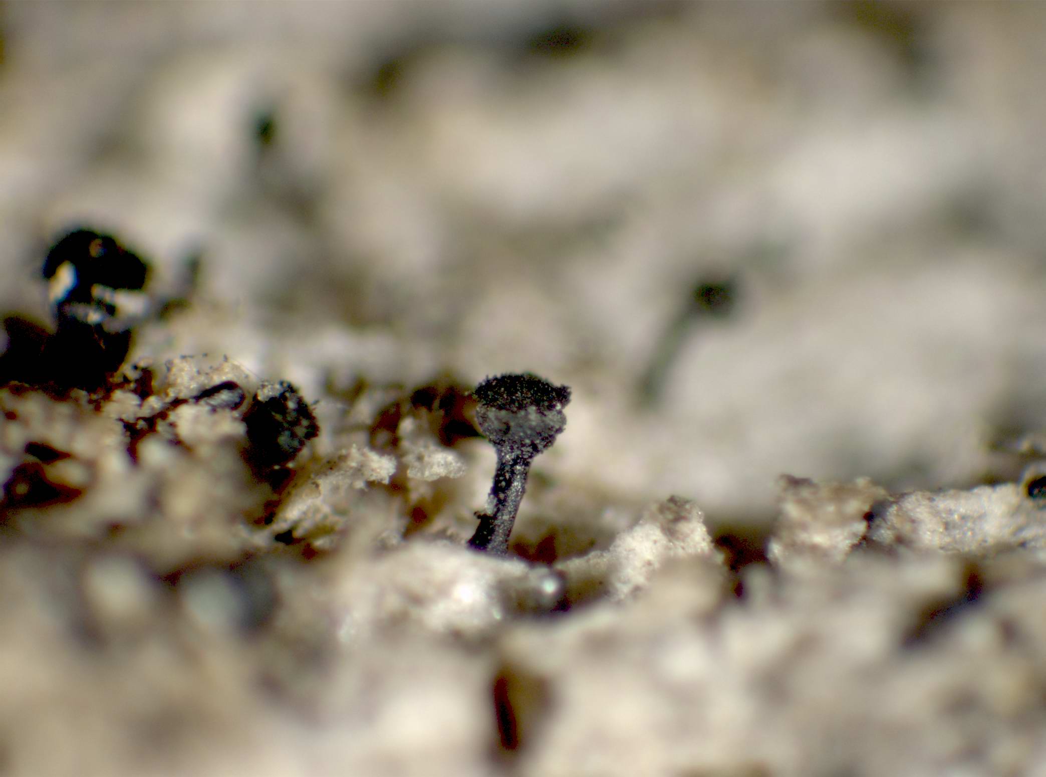
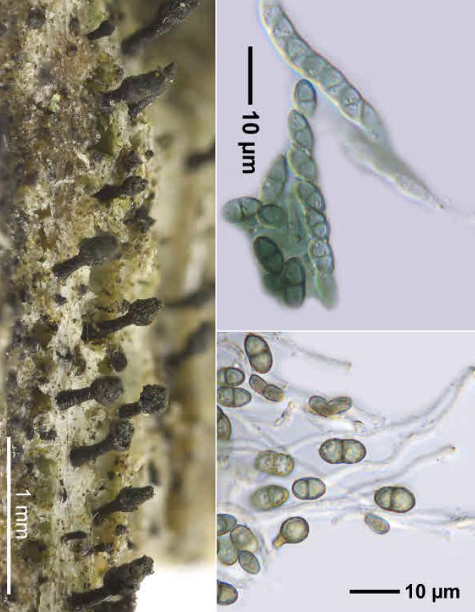
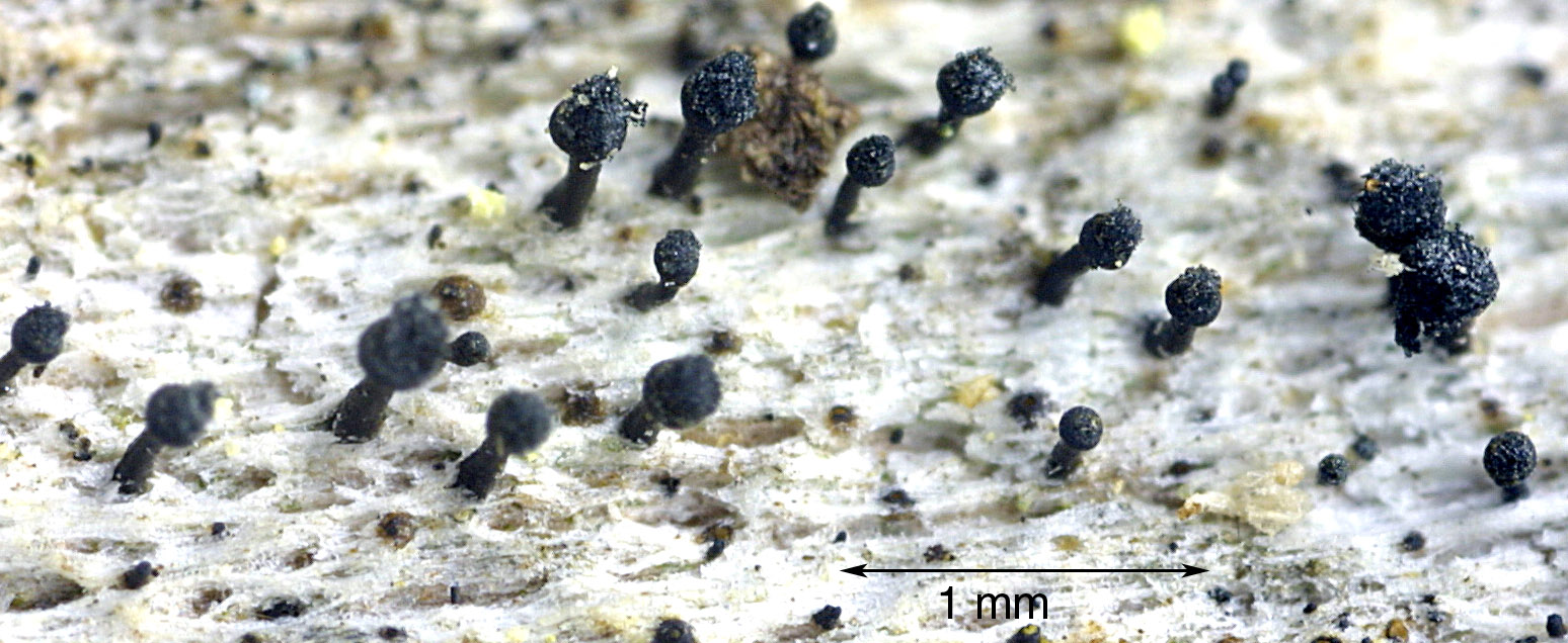
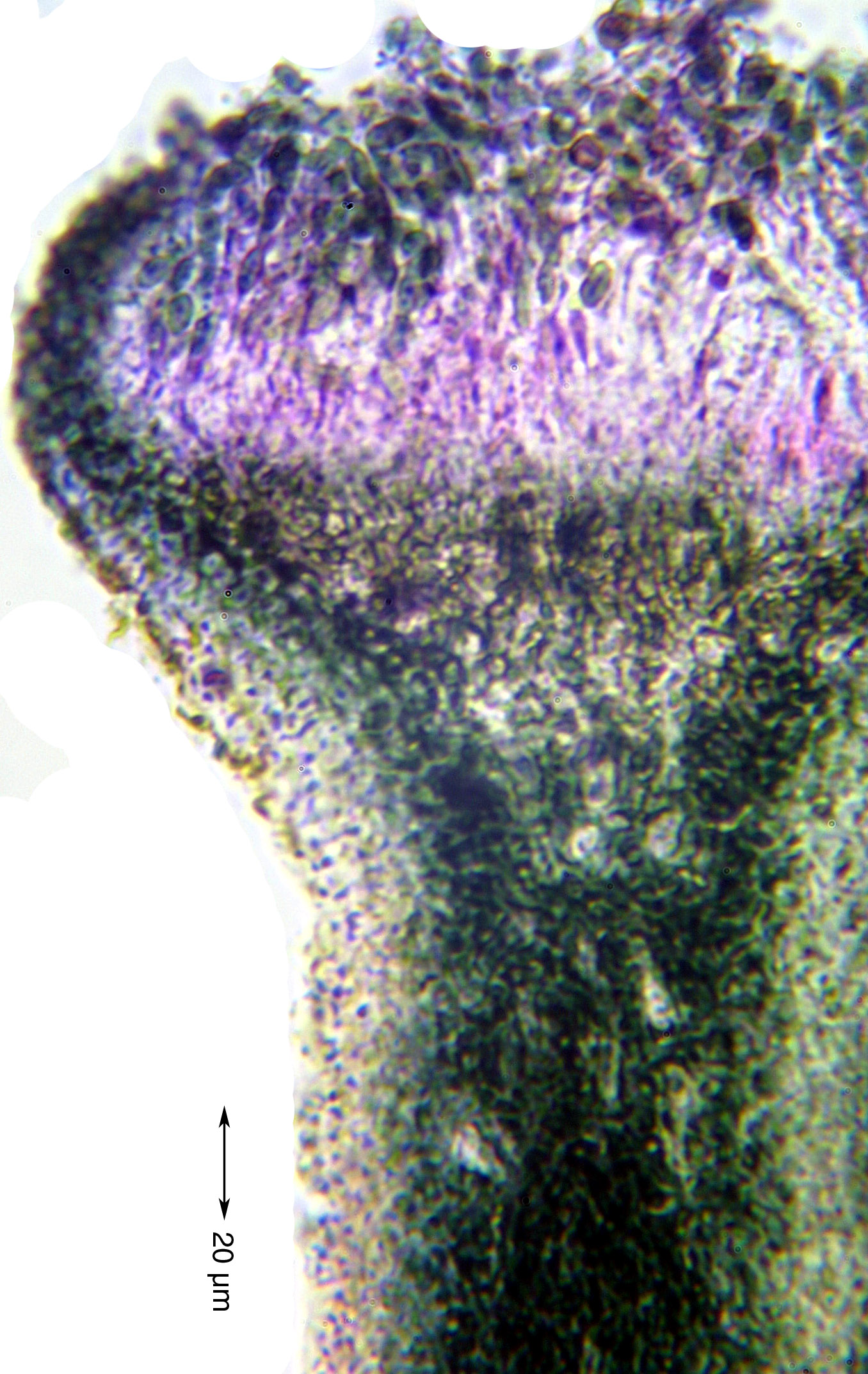
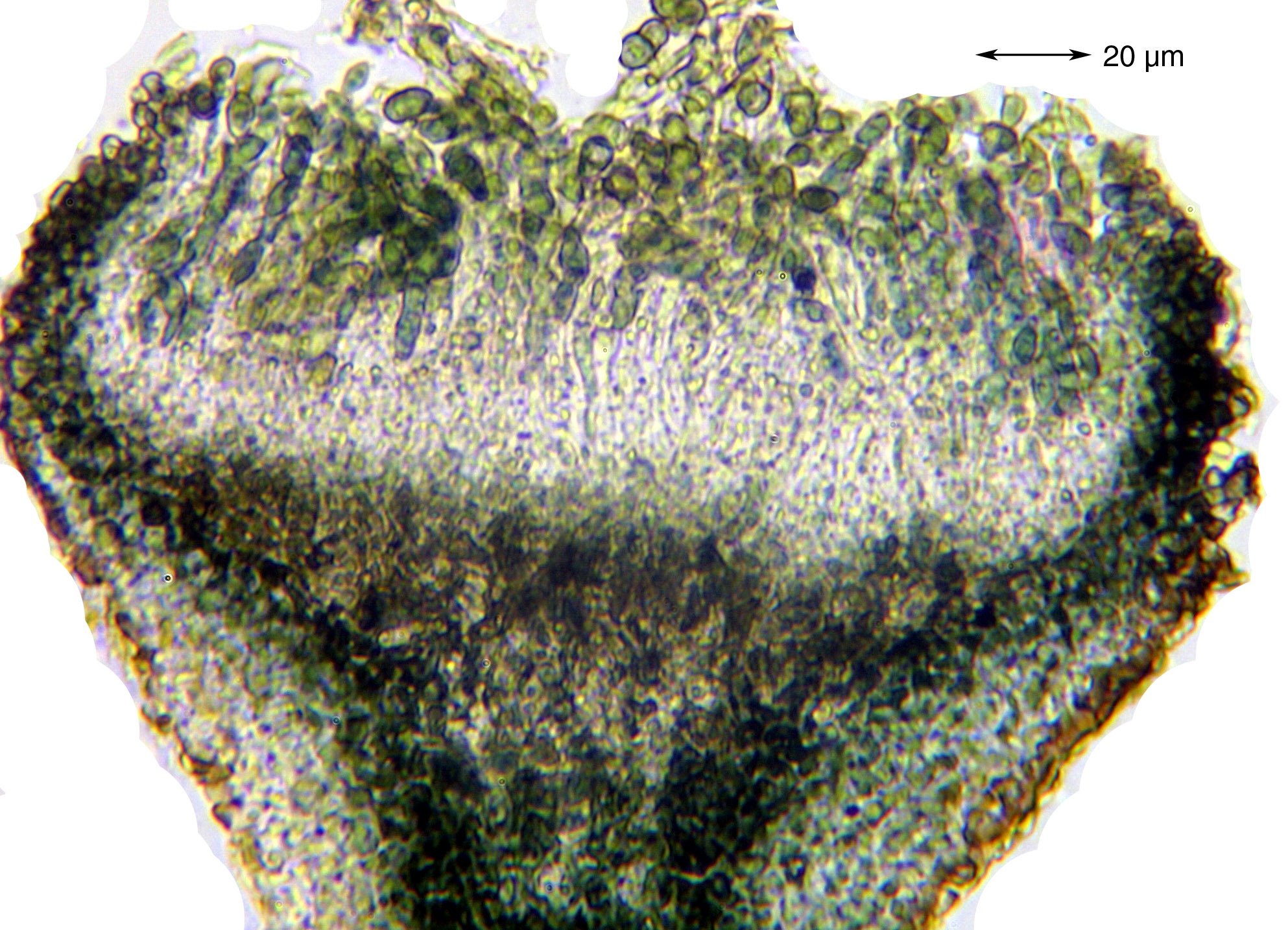
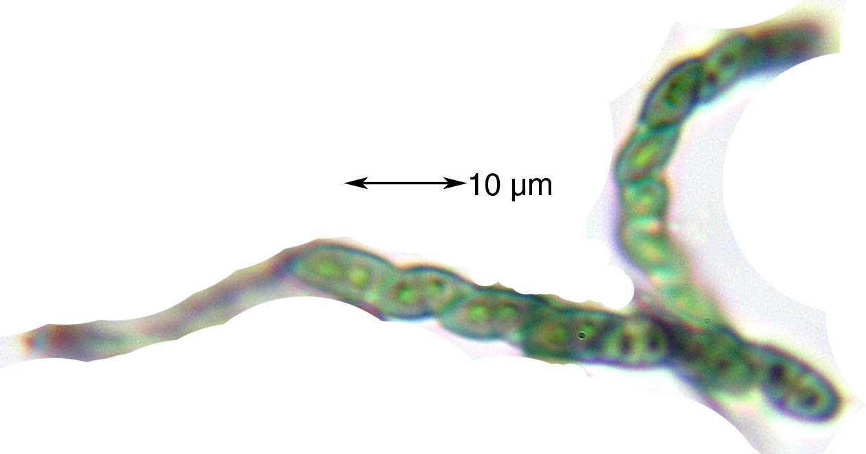
Description: Thallus crustose, endosubstratic, thin and poorly evident. Apothecia long-stalked, pin-like, epruinose, black, or the stalk tinged brown. Stalk 0.6-1 mm high, of sclerotized, dark, irregularly interwoven hyphae, the outer layer covered with a thin, transparent gelatinous sheath. Capitulum 0.2-0.3 mm across, lenticular to bell-shaped, with an exciple of anticlinally oriented, heavily sclerotized cells; mazaedium well developed, black; hypothecium dark. Asci cylindrical, formed singly, dissolving early, with uniseriate ascospores. Ascospores 1-septate, dark brown, ellipsoid, 12-15 x 5-7 µm, with a thick, minutely warted to cracked-areolate wall. Photobiont chlorococcoid. Spot tests: thallus K-, C-, KC-, P-; ascomata I- in all parts. Chemistry: without lichen substances.Note: a temperate to boreal-montane, circumpolar species found on old but hard wood of conifers, but also on bark, especially of Abies, much more rarely on deciduous trees (e.g. on Castanea) and, in humid areas, on wooden poles, with optimum in the montane belt. Old records (Nimis 1993: 148) might refer to C. glaucellum.
Growth form: Crustose
Substrata: bark and lignum
Photobiont: green algae other than Trentepohlia
Reproductive strategy: mainly sexual
In underhangs rarely wetted by rain
Commonnes-rarity: (info)
Alpine belt: absent
Subalpine belt: very rare
Oromediterranean belt: absent
Montane belt: rare
Submediterranean belt: extremely rare
Padanian area: absent
Humid submediterranean belt: very rare
Humid mediterranean belt: absent
Dry mediterranean belt: absent
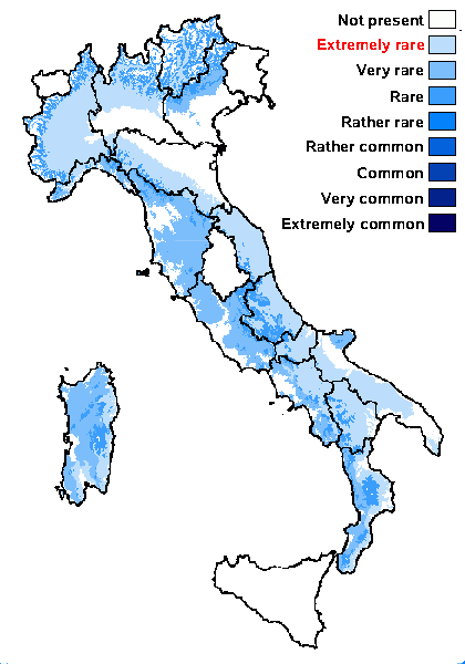
Predictive model
Herbarium samples

Felix Schumm – CC BY-SA 4.0
[13629] Germany, Baden-Württemberg, Kreis Göppingen, südwestlich von Adelberg nahe dem Herrenbachstausee, Buhwiesenweg, entrindete alte abgestorbene Baumstämme im Mischwald, ca. 48°44' N, 9°33' E, 412 m. Leg. Schumm 08.02.2008
E. Pittao; Owner: Department of Life Sciences, University of Trieste
Herbarium: TSB (9059)
2008.03.11

E. Pittao; Owner: Department of Life Sciences, University of Trieste
Herbarium: TSB (9059)
2008.03.11
E. Pittao; Owner: Department of Life Sciences, University of Trieste
Herbarium: TSB (9059)
2008.03.11
P.L. Nimis; Owner: Department of Life Sciences, University of Trieste
Herbarium: TSB (7059)
2001/12/05
Felix Schumm – CC BY-SA 4.0
[15682], Germany, Kreis Göppingen, zwischen Wangen und Unterberken (TK: 7223, 48,75° N, 9,58° E, 480 m), auf morschem Holzbalken; leg. 13.12.2009 FS
Felix Schumm – CC BY-SA 4.0
[13629] Germany, Baden-Württemberg, Kreis Göppingen, südwestlich von Adelberg nahe dem Herrenbachstausee, Buhwiesenweg, entrindete alte abgestorbene Baumstämme im Mischwald, ca. 48°44' N, 9°33' E, 412 m. Leg. Schumm 08.02.2008
Felix Schumm – CC BY-SA 4.0
[13629] Germany, Baden-Württemberg, Kreis Göppingen, südwestlich von Adelberg nahe dem Herrenbachstausee, Buhwiesenweg, entrindete alte abgestorbene Baumstämme im Mischwald, ca. 48°44' N, 9°33' E, 412 m. Leg. Schumm 08.02.2008
Felix Schumm – CC BY-SA 4.0
[13629] Germany, Baden-Württemberg, Kreis Göppingen, südwestlich von Adelberg nahe dem Herrenbachstausee, Buhwiesenweg, entrindete alte abgestorbene Baumstämme im Mischwald, ca. 48°44' N, 9°33' E, 412 m. Leg. Schumm 08.02.2008
Felix Schumm – CC BY-SA 4.0
[13629] Germany, Baden-Württemberg, Kreis Göppingen, südwestlich von Adelberg nahe dem Herrenbachstausee, Buhwiesenweg, entrindete alte abgestorbene Baumstämme im Mischwald, ca. 48°44' N, 9°33' E, 412 m. Leg. Schumm 08.02.2008

Felix Schumm – CC BY-SA 4.0
[13629] Germany, Baden-Württemberg, Kreis Göppingen, südwestlich von Adelberg nahe dem Herrenbachstausee, Buhwiesenweg, entrindete alte abgestorbene Baumstämme im Mischwald, ca. 48°44' N, 9°33' E, 412 m. Leg. Schumm 08.02.2008
Felix Schumm – CC BY-SA 4.0
[13629] Germany, Baden-Württemberg, Kreis Göppingen, südwestlich von Adelberg nahe dem Herrenbachstausee, Buhwiesenweg, entrindete alte abgestorbene Baumstämme im Mischwald, ca. 48°44' N, 9°33' E, 412 m. Leg. Schumm 08.02.2008
Felix Schumm – CC BY-SA 4.0
[13629] Germany, Baden-Württemberg, Kreis Göppingen, südwestlich von Adelberg nahe dem Herrenbachstausee, Buhwiesenweg, entrindete alte abgestorbene Baumstämme im Mischwald, ca. 48°44' N, 9°33' E, 412 m. Leg. Schumm 08.02.2008
Felix Schumm – CC BY-SA 4.0
[13629] Germany, Baden-Württemberg, Kreis Göppingen, südwestlich von Adelberg nahe dem Herrenbachstausee, Buhwiesenweg, entrindete alte abgestorbene Baumstämme im Mischwald, ca. 48°44' N, 9°33' E, 412 m. Leg. Schumm 08.02.2008

Felix Schumm – CC BY-SA 4.0
[13629] Germany, Baden-Württemberg, Kreis Göppingen, südwestlich von Adelberg nahe dem Herrenbachstausee, Buhwiesenweg, entrindete alte abgestorbene Baumstämme im Mischwald, ca. 48°44' N, 9°33' E, 412 m. Leg. Schumm 08.02.2008
Felix Schumm – CC BY-SA 4.0
[13629] Germany, Baden-Württemberg, Kreis Göppingen, südwestlich von Adelberg nahe dem Herrenbachstausee, Buhwiesenweg, entrindete alte abgestorbene Baumstämme im Mischwald, ca. 48°44' N, 9°33' E, 412 m. Leg. Schumm 08.02.2008

Felix Schumm – CC BY-SA 4.0
[13629] Germany, Baden-Württemberg, Kreis Göppingen, südwestlich von Adelberg nahe dem Herrenbachstausee, Buhwiesenweg, entrindete alte abgestorbene Baumstämme im Mischwald, ca. 48°44' N, 9°33' E, 412 m. Leg. Schumm 08.02.2008
Felix Schumm – CC BY-SA 4.0
[13629] Germany, Baden-Württemberg, Kreis Göppingen, südwestlich von Adelberg nahe dem Herrenbachstausee, Buhwiesenweg, entrindete alte abgestorbene Baumstämme im Mischwald, ca. 48°44' N, 9°33' E, 412 m. Leg. Schumm 08.02.2008
Felix Schumm – CC BY-SA 4.0
[13629] Germany, Baden-Württemberg, Kreis Göppingen, südwestlich von Adelberg nahe dem Herrenbachstausee, Buhwiesenweg, entrindete alte abgestorbene Baumstämme im Mischwald, ca. 48°44' N, 9°33' E, 412 m. Leg. Schumm 08.02.2008
Felix Schumm – CC BY-SA 4.0
[15682], Germany, Kreis Göppingen, zwischen Wangen und Unterberken (TK: 7223, 48,75° N, 9,58° E, 480 m), auf morschem Holzbalken; leg. 13.12.2009 FS
Felix Schumm – CC BY-SA 4.0
[15682], Germany, Kreis Göppingen, zwischen Wangen und Unterberken (TK: 7223, 48,75° N, 9,58° E, 480 m), auf morschem Holzbalken; leg. 13.12.2009 FS
Felix Schumm – CC BY-SA 4.0
[15682], Germany, Kreis Göppingen, zwischen Wangen und Unterberken (TK: 7223, 48,75° N, 9,58° E, 480 m), auf morschem Holzbalken; leg. 13.12.2009 FS
Ulrich Kirschbaum CC BY-SA 4.0 - Source: https://www.thm.de/lse/ulrich-kirschbaum/flechtenbilder
On a dead Quercus tree.
Central Europe; Germany; Hesse: Vogelsberg. (Collected by M. Heerd).
Growth form: Crustose
Substrata: bark and lignum
Photobiont: green algae other than Trentepohlia
Reproductive strategy: mainly sexual
In underhangs rarely wetted by rain
Commonnes-rarity: (info)
Alpine belt: absent
Subalpine belt: very rare
Oromediterranean belt: absent
Montane belt: rare
Submediterranean belt: extremely rare
Padanian area: absent
Humid submediterranean belt: very rare
Humid mediterranean belt: absent
Dry mediterranean belt: absent
Predictive model
| Herbarium samples |

Felix Schumm – CC BY-SA 4.0
[13629] Germany, Baden-Württemberg, Kreis Göppingen, südwestlich von Adelberg nahe dem Herrenbachstausee, Buhwiesenweg, entrindete alte abgestorbene Baumstämme im Mischwald, ca. 48°44' N, 9°33' E, 412 m. Leg. Schumm 08.02.2008

E. Pittao; Owner: Department of Life Sciences, University of Trieste
Herbarium: TSB (9059)
2008.03.11
E. Pittao; Owner: Department of Life Sciences, University of Trieste
Herbarium: TSB (9059)
2008.03.11

E. Pittao; Owner: Department of Life Sciences, University of Trieste
Herbarium: TSB (9059)
2008.03.11
P.L. Nimis; Owner: Department of Life Sciences, University of Trieste
Herbarium: TSB (7059)
2001/12/05
Felix Schumm – CC BY-SA 4.0
[15682], Germany, Kreis Göppingen, zwischen Wangen und Unterberken (TK: 7223, 48,75° N, 9,58° E, 480 m), auf morschem Holzbalken; leg. 13.12.2009 FS

Felix Schumm – CC BY-SA 4.0
[13629] Germany, Baden-Württemberg, Kreis Göppingen, südwestlich von Adelberg nahe dem Herrenbachstausee, Buhwiesenweg, entrindete alte abgestorbene Baumstämme im Mischwald, ca. 48°44' N, 9°33' E, 412 m. Leg. Schumm 08.02.2008
Felix Schumm – CC BY-SA 4.0
[13629] Germany, Baden-Württemberg, Kreis Göppingen, südwestlich von Adelberg nahe dem Herrenbachstausee, Buhwiesenweg, entrindete alte abgestorbene Baumstämme im Mischwald, ca. 48°44' N, 9°33' E, 412 m. Leg. Schumm 08.02.2008
Felix Schumm – CC BY-SA 4.0
[13629] Germany, Baden-Württemberg, Kreis Göppingen, südwestlich von Adelberg nahe dem Herrenbachstausee, Buhwiesenweg, entrindete alte abgestorbene Baumstämme im Mischwald, ca. 48°44' N, 9°33' E, 412 m. Leg. Schumm 08.02.2008

Felix Schumm – CC BY-SA 4.0
[13629] Germany, Baden-Württemberg, Kreis Göppingen, südwestlich von Adelberg nahe dem Herrenbachstausee, Buhwiesenweg, entrindete alte abgestorbene Baumstämme im Mischwald, ca. 48°44' N, 9°33' E, 412 m. Leg. Schumm 08.02.2008
Felix Schumm – CC BY-SA 4.0
[13629] Germany, Baden-Württemberg, Kreis Göppingen, südwestlich von Adelberg nahe dem Herrenbachstausee, Buhwiesenweg, entrindete alte abgestorbene Baumstämme im Mischwald, ca. 48°44' N, 9°33' E, 412 m. Leg. Schumm 08.02.2008

Felix Schumm – CC BY-SA 4.0
[13629] Germany, Baden-Württemberg, Kreis Göppingen, südwestlich von Adelberg nahe dem Herrenbachstausee, Buhwiesenweg, entrindete alte abgestorbene Baumstämme im Mischwald, ca. 48°44' N, 9°33' E, 412 m. Leg. Schumm 08.02.2008

Felix Schumm – CC BY-SA 4.0
[13629] Germany, Baden-Württemberg, Kreis Göppingen, südwestlich von Adelberg nahe dem Herrenbachstausee, Buhwiesenweg, entrindete alte abgestorbene Baumstämme im Mischwald, ca. 48°44' N, 9°33' E, 412 m. Leg. Schumm 08.02.2008

Felix Schumm – CC BY-SA 4.0
[13629] Germany, Baden-Württemberg, Kreis Göppingen, südwestlich von Adelberg nahe dem Herrenbachstausee, Buhwiesenweg, entrindete alte abgestorbene Baumstämme im Mischwald, ca. 48°44' N, 9°33' E, 412 m. Leg. Schumm 08.02.2008

Felix Schumm – CC BY-SA 4.0
[13629] Germany, Baden-Württemberg, Kreis Göppingen, südwestlich von Adelberg nahe dem Herrenbachstausee, Buhwiesenweg, entrindete alte abgestorbene Baumstämme im Mischwald, ca. 48°44' N, 9°33' E, 412 m. Leg. Schumm 08.02.2008

Felix Schumm – CC BY-SA 4.0
[13629] Germany, Baden-Württemberg, Kreis Göppingen, südwestlich von Adelberg nahe dem Herrenbachstausee, Buhwiesenweg, entrindete alte abgestorbene Baumstämme im Mischwald, ca. 48°44' N, 9°33' E, 412 m. Leg. Schumm 08.02.2008
Felix Schumm – CC BY-SA 4.0
[13629] Germany, Baden-Württemberg, Kreis Göppingen, südwestlich von Adelberg nahe dem Herrenbachstausee, Buhwiesenweg, entrindete alte abgestorbene Baumstämme im Mischwald, ca. 48°44' N, 9°33' E, 412 m. Leg. Schumm 08.02.2008

Felix Schumm – CC BY-SA 4.0
[13629] Germany, Baden-Württemberg, Kreis Göppingen, südwestlich von Adelberg nahe dem Herrenbachstausee, Buhwiesenweg, entrindete alte abgestorbene Baumstämme im Mischwald, ca. 48°44' N, 9°33' E, 412 m. Leg. Schumm 08.02.2008

Felix Schumm – CC BY-SA 4.0
[13629] Germany, Baden-Württemberg, Kreis Göppingen, südwestlich von Adelberg nahe dem Herrenbachstausee, Buhwiesenweg, entrindete alte abgestorbene Baumstämme im Mischwald, ca. 48°44' N, 9°33' E, 412 m. Leg. Schumm 08.02.2008

Felix Schumm – CC BY-SA 4.0
[15682], Germany, Kreis Göppingen, zwischen Wangen und Unterberken (TK: 7223, 48,75° N, 9,58° E, 480 m), auf morschem Holzbalken; leg. 13.12.2009 FS

Felix Schumm – CC BY-SA 4.0
[15682], Germany, Kreis Göppingen, zwischen Wangen und Unterberken (TK: 7223, 48,75° N, 9,58° E, 480 m), auf morschem Holzbalken; leg. 13.12.2009 FS

Felix Schumm – CC BY-SA 4.0
[15682], Germany, Kreis Göppingen, zwischen Wangen und Unterberken (TK: 7223, 48,75° N, 9,58° E, 480 m), auf morschem Holzbalken; leg. 13.12.2009 FS