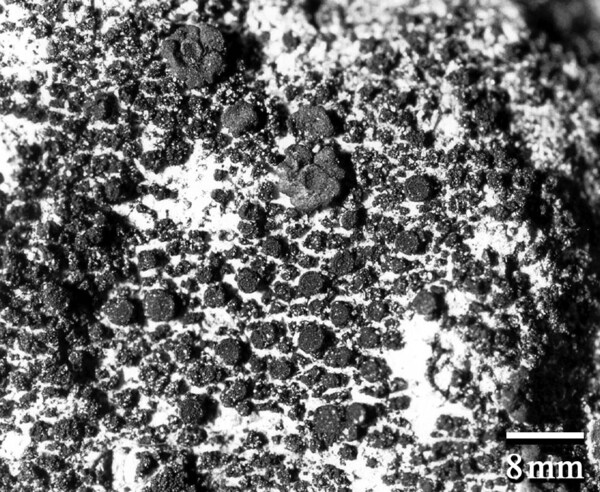
Lemmopsis arnoldiana (Hepp) Zahlbr.

in Engler & Prantl, Natürl. Pflanzenfam., 1: 171, 1906. Basionym: Physma arnoldianum Hepp in Arnold - Flora, 41: 94, 1858.
Synonyms: Lemmopsis fulvida (Harm.) Lettau; Leptogium fulvidum Harm.; Psorotichia arnoldiana (Hepp) Körb.; Pyrenocarpon arnoldianum (Hepp) Trevis.
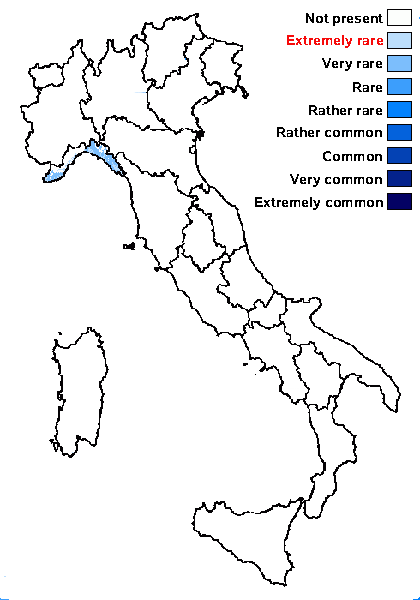
Distribution: N - Lig.
Description: Thallus crustose, homoiomerous, gelatinous when wet, brown, brown-black or black, areolate to granulose. Areoles 0.25-0.5 mm wide, angular to irregular in outline, paraplectenchymatous throughout, attached by rhizohyphae. Apothecia hemiangiocarpic, the ascogonia arising in a tangle of generative hyphae beneath the thallus surface, zeorine, sessile, up to 0.7 mm across, urceolate and almost perithecioid, with a pore-like, flat, dark red-brown disc, a golden yellow, prominent parathecial ring, and a thin, often soon excluded thalline margin. Proper exciple up to 50 μm wide, of interwoven, gelatinized hyphae, golden yellow to reddish brown in upper part, colourless in lower part; epithecium reddish brown; hymenium colourless, 100-120 μm high, I+ blue, K/I+ blue; paraphyses slender, coherent, branched and anastomosing, the apical cells 3-5 μm wide; hypothecium colourless. Asci 8-spored, cylindrical-clavate, thin-walled, the outer layer K/I+ blue. Ascospores 1-celled, hyaline, broadly ellipsoid to ellipsoid, 13-25 x 8-12 μm, thin-walled. Pycnidia immersed, globose. Conidia ellipsoid, 3-4 x c. 1.5 μm. Photobiont cyanobacterial, the cells in clusters, surrounded by a yellowish brown (in peripheral parts) to colourless (in inner parts) gelatinous sheath. Spot tests K-, C-, KC-, P-, UV-. Chemistry: without lichen substances.
Note: on calcareous pebbles in shaded woodland floors and crevices in rocky quarries, sometimes on mortar; in Italy the species is known from a single station in Liguria, but perhaps was overlooked and is somehow more frequent in Tyrrhenian Italy, albeit certainly not common.
Growth form: Crustose
Substrata: rocks
Photobiont: cyanobacteria, coccaceous (e.g. Gloeocapsa)
Reproductive strategy: mainly sexual
Most common in areas with a humid-warm climate (e.g. most of Tyrrenian Italy)

Commonnes-rarity: (info)

Alpine belt: absent
Subalpine belt: absent
Oromediterranean belt: absent
Montane belt: absent
Submediterranean belt: absent
Padanian area: absent
Humid submediterranean belt: very rare
Humid mediterranean belt: extremely rare
Dry mediterranean belt: absent
pH of the substrata:

12345

Solar irradiation:

12345

Aridity:

12345

Eutrophication:

12345

Poleotolerance:

0123

Altitudinal distribution:

123456


Predictive model


Felix Schumm - CC BY-SA 4.0
[Yazici1104], Turkey, Bucak, Kizilli köyüne giderken, yol üzeri ve orman içi. 37°21’54’’ N, 30°52’56.52’’ E, 394 m. Leg. K. Yazici (no 1104), det. A. Aptroot, 2014.


Felix Schumm - CC BY-SA 4.0
[ABL53071a], Taiwan, Pingtung Couty, 45 km SE of Kaohsiumg, near Fangshan, rock conglomeratic outcrops. 22°09’45 N, 120°41’54’’ E, 20 m. Leg. A. Aptroot (no 53071a), 12.10.2001, det. M. Schultz, 07.2007.


Felix Schumm - CC BY-SA 4.0
[ABL53071a], Taiwan, Pingtung Couty, 45 km SE of Kaohsiumg, near Fangshan, rock conglomeratic outcrops. 22°09’45 N, 120°41’54’’ E, 20 m. Leg. A. Aptroot (no 53071a), 12.10.2001, det. M. Schultz, 07.2007.


Felix Schumm - CC BY-SA 4.0
[ABL53071a], Taiwan, Pingtung Couty, 45 km SE of Kaohsiumg, near Fangshan, rock conglomeratic outcrops. 22°09’45 N, 120°41’54’’ E, 20 m. Leg. A. Aptroot (no 53071a), 12.10.2001, det. M. Schultz, 07.2007.


Felix Schumm - CC BY-SA 4.0
[ABL53071a], Taiwan, Pingtung Couty, 45 km SE of Kaohsiumg, near Fangshan, rock conglomeratic outcrops. 22°09’45 N, 120°41’54’’ E, 20 m. Leg. A. Aptroot (no 53071a), 12.10.2001, det. M. Schultz, 07.2007.


Felix Schumm - CC BY-SA 4.0
[ABL53071a], Taiwan, Pingtung Couty, 45 km SE of Kaohsiumg, near Fangshan, rock conglomeratic outcrops. 22°09’45 N, 120°41’54’’ E, 20 m. Leg. A. Aptroot (no 53071a), 12.10.2001, det. M. Schultz, 07.2007.


Felix Schumm - CC BY-SA 4.0
[ABL53071a], Taiwan, Pingtung Couty, 45 km SE of Kaohsiumg, near Fangshan, rock conglomeratic outcrops. 22°09’45 N, 120°41’54’’ E, 20 m. Leg. A. Aptroot (no 53071a), 12.10.2001, det. M. Schultz, 07.2007.


Felix Schumm - CC BY-SA 4.0
[ABL53071a], Taiwan, Pingtung Couty, 45 km SE of Kaohsiumg, near Fangshan, rock conglomeratic outcrops. 22°09’45 N, 120°41’54’’ E, 20 m. Leg. A. Aptroot (no 53071a), 12.10.2001, det. M. Schultz, 07.2007.


Matthias Schultz –Source: https://lichenportal.org/cnalh/taxa/index.php?taxon=55767&clid=1184


Felix Schumm - CC BY-SA 4.0
[Yazici1104], Turkey, Bucak, Kizilli köyüne giderken, yol üzeri ve orman içi. 37°21’54’’ N, 30°52’56.52’’ E, 394 m. Leg. K. Yazici (no 1104), det. A. Aptroot, 2014.


Felix Schumm - CC BY-SA 4.0
[Yazici1104], Turkey, Bucak, Kizilli köyüne giderken, yol üzeri ve orman içi. 37°21’54’’ N, 30°52’56.52’’ E, 394 m. Leg. K. Yazici (no 1104), det. A. Aptroot, 2014.


Felix Schumm - CC BY-SA 4.0
[Yazici1104], Turkey, Bucak, Kizilli köyüne giderken, yol üzeri ve orman içi. 37°21’54’’ N, 30°52’56.52’’ E, 394 m. Leg. K. Yazici (no 1104), det. A. Aptroot, 2014.


Felix Schumm - CC BY-SA 4.0
[Yazici1104], Turkey, Bucak, Kizilli köyüne giderken, yol üzeri ve orman içi. 37°21’54’’ N, 30°52’56.52’’ E, 394 m. Leg. K. Yazici (no 1104), det. A. Aptroot, 2014.


Felix Schumm - CC BY-SA 4.0
[Yazici1104], Turkey, Bucak, Kizilli köyüne giderken, yol üzeri ve orman içi. 37°21’54’’ N, 30°52’56.52’’ E, 394 m. Leg. K. Yazici (no 1104), det. A. Aptroot, 2014.


Felix Schumm - CC BY-SA 4.0
[Yazici1104], Turkey, Bucak, Kizilli köyüne giderken, yol üzeri ve orman içi. 37°21’54’’ N, 30°52’56.52’’ E, 394 m. Leg. K. Yazici (no 1104), det. A. Aptroot, 2014.


Felix Schumm - CC BY-SA 4.0
[Yazici1104], Turkey, Bucak, Kizilli köyüne giderken, yol üzeri ve orman içi. 37°21’54’’ N, 30°52’56.52’’ E, 394 m. Leg. K. Yazici (no 1104), det. A. Aptroot, 2014.


Felix Schumm - CC BY-SA 4.0
[Yazici1104], Turkey, Bucak, Kizilli köyüne giderken, yol üzeri ve orman içi. 37°21’54’’ N, 30°52’56.52’’ E, 394 m. Leg. K. Yazici (no 1104), det. A. Aptroot, 2014.


Felix Schumm - CC BY-SA 4.0
[Yazici1104], Turkey, Bucak, Kizilli köyüne giderken, yol üzeri ve orman içi. 37°21’54’’ N, 30°52’56.52’’ E, 394 m. Leg. K. Yazici (no 1104), det. A. Aptroot, 2014.