Lecanora argentata (Ach.) Malme
Lich. Suec. Exs.: nr. 5, 1897. Basionym: Parmelia subfusca var. argentata Ach. - Meth. Lich.: 169, 1803.
Synonyms: Lecanora subfusca auct. p.p.; Lecanora subfuscata H. Magn.; Lecanora subrugosa Nyl.
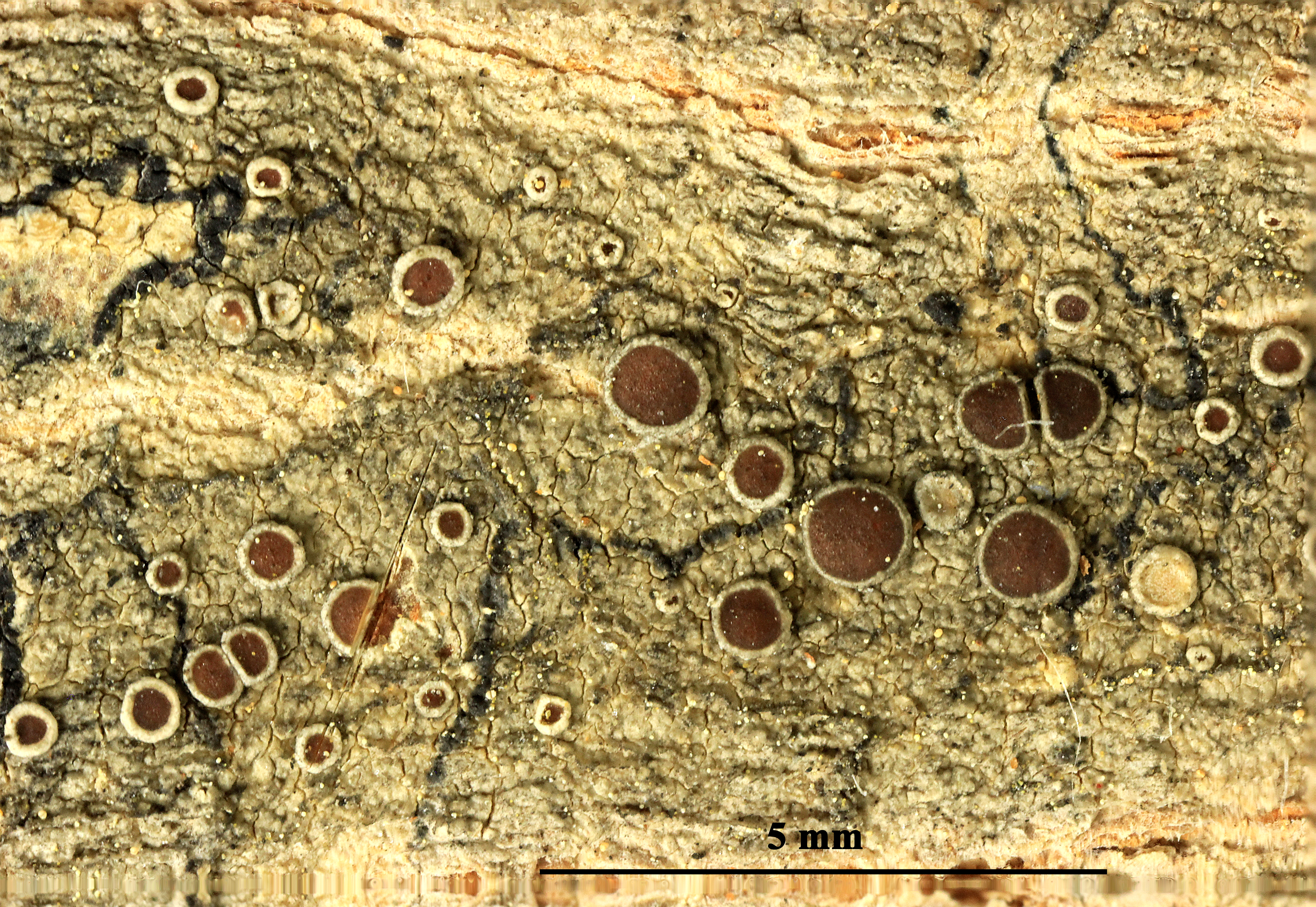
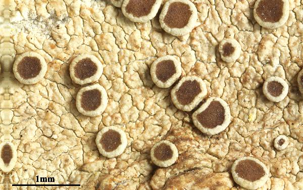
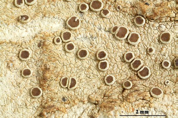
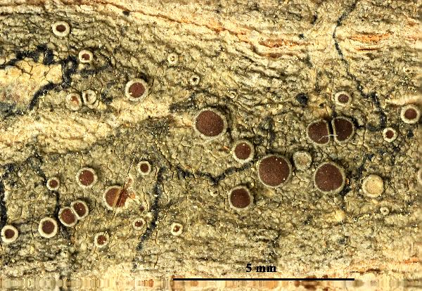
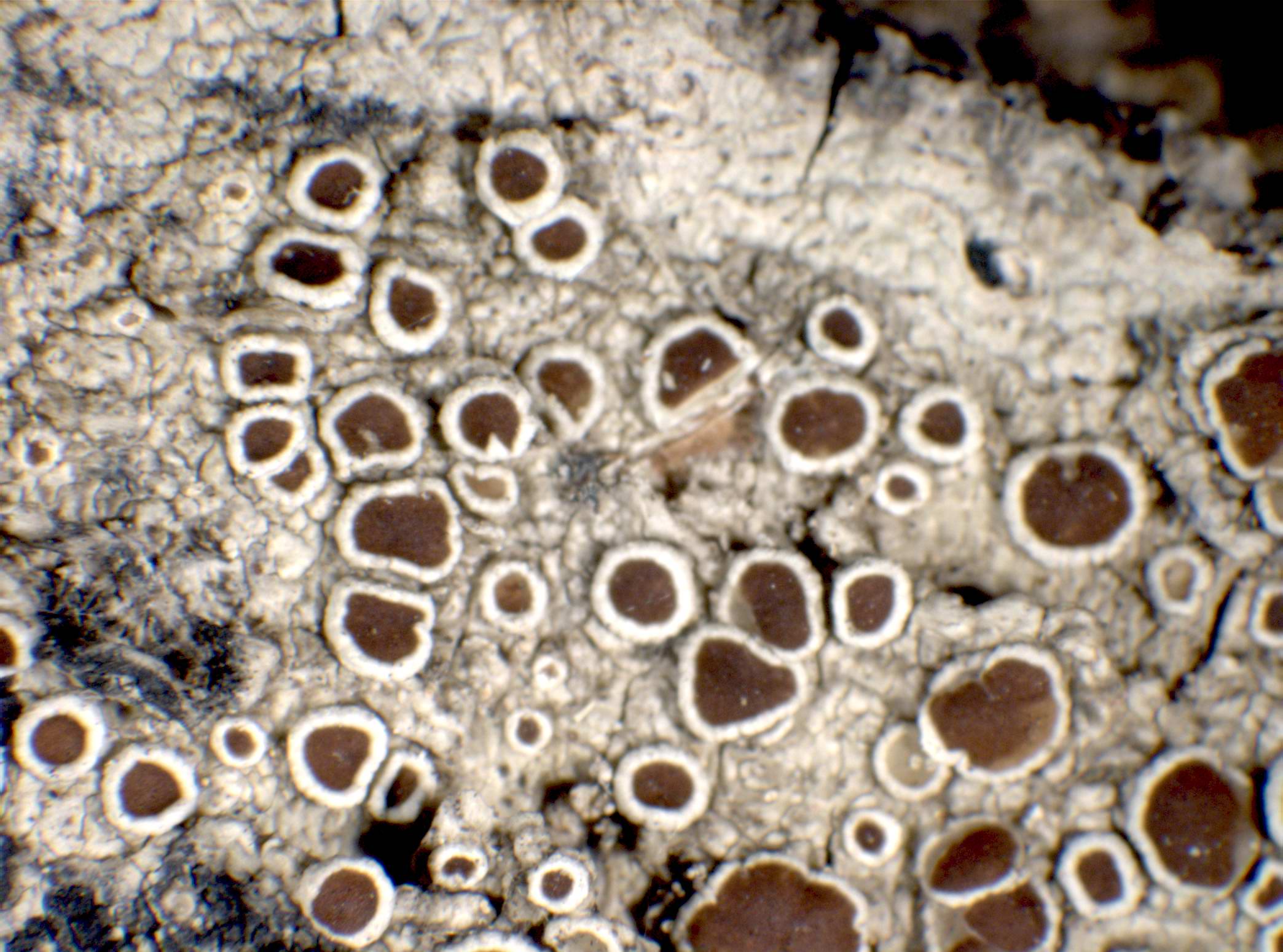
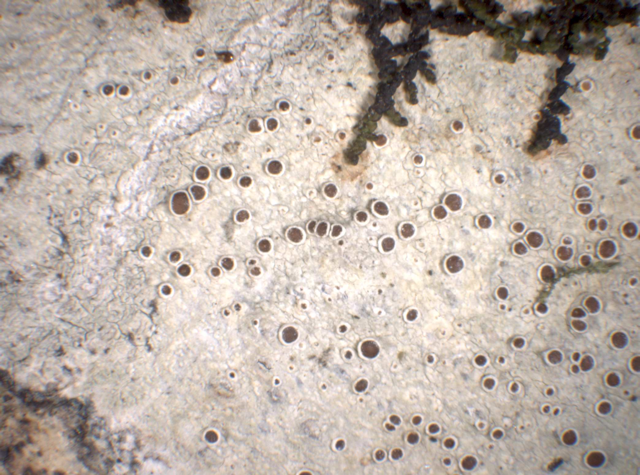
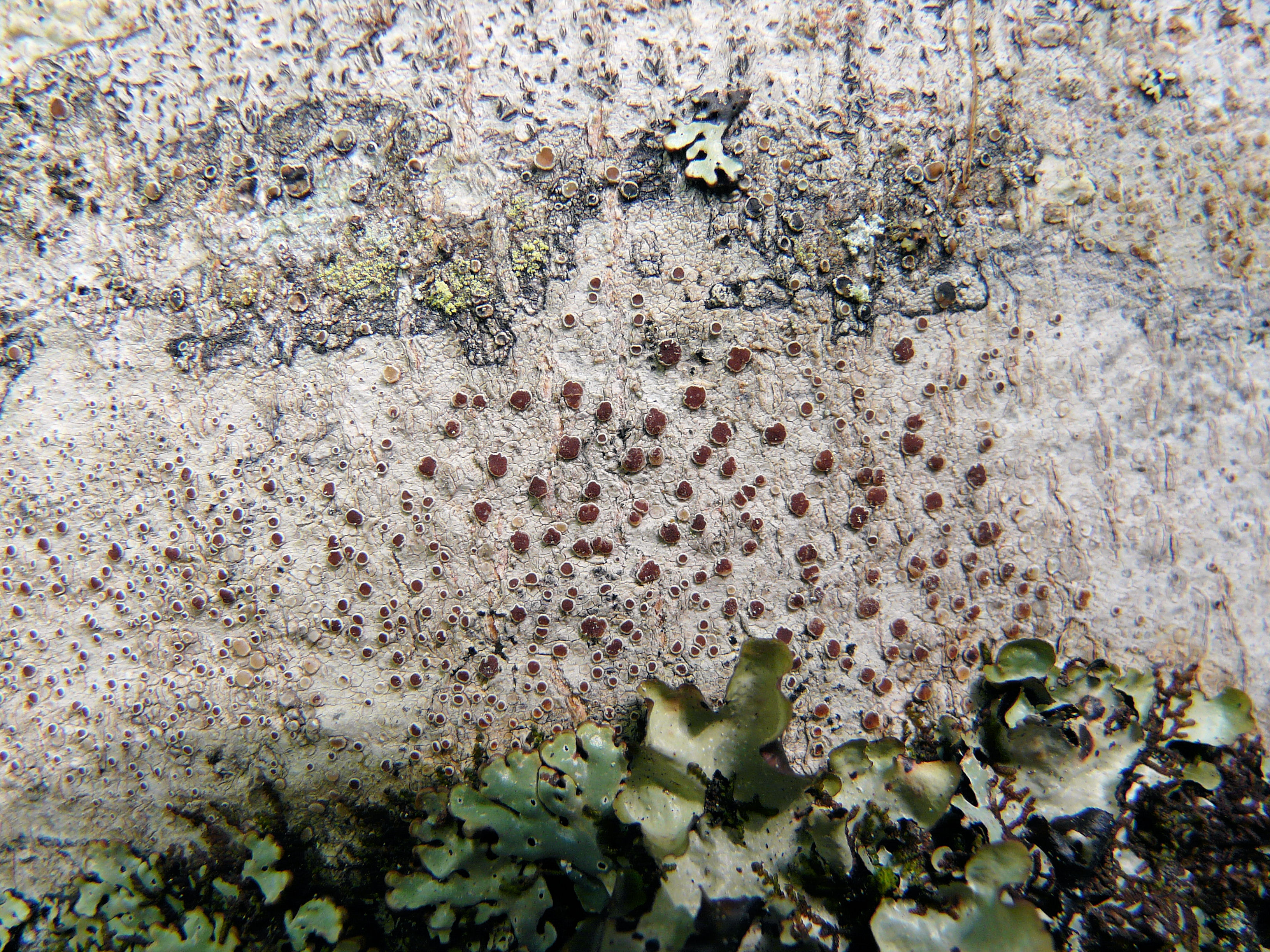
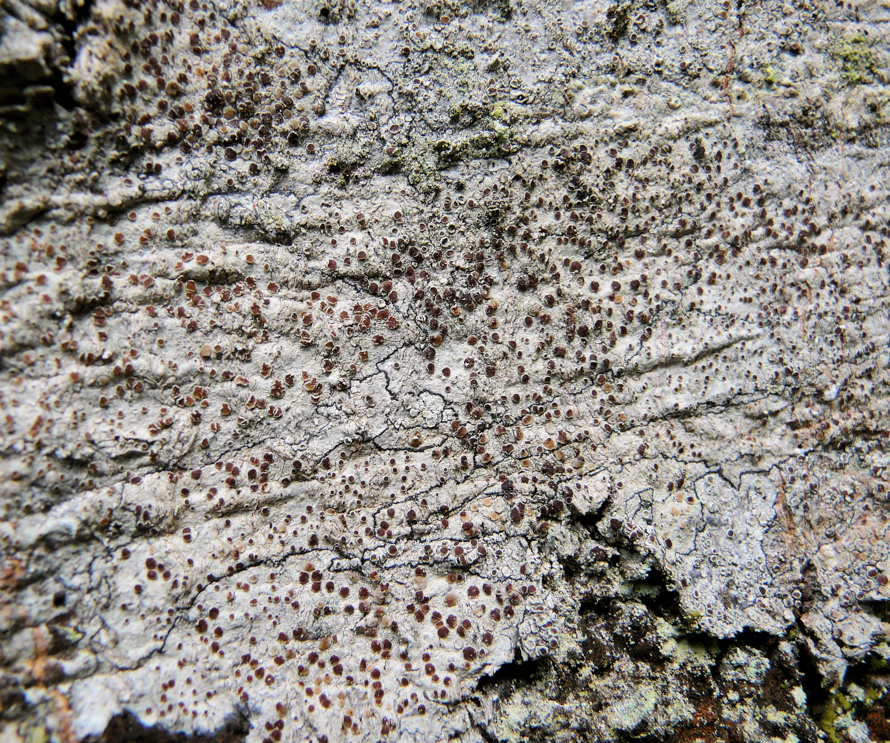
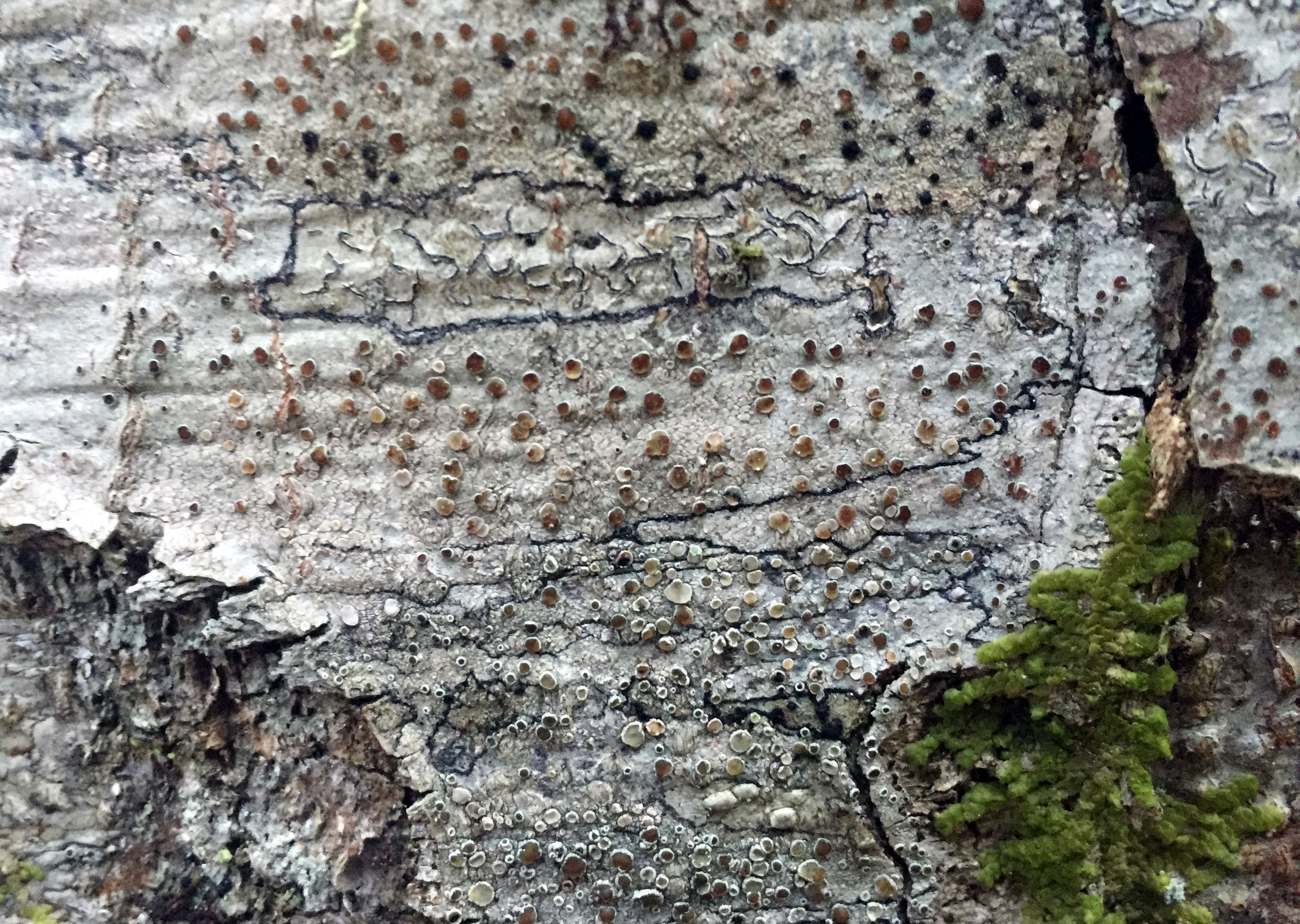
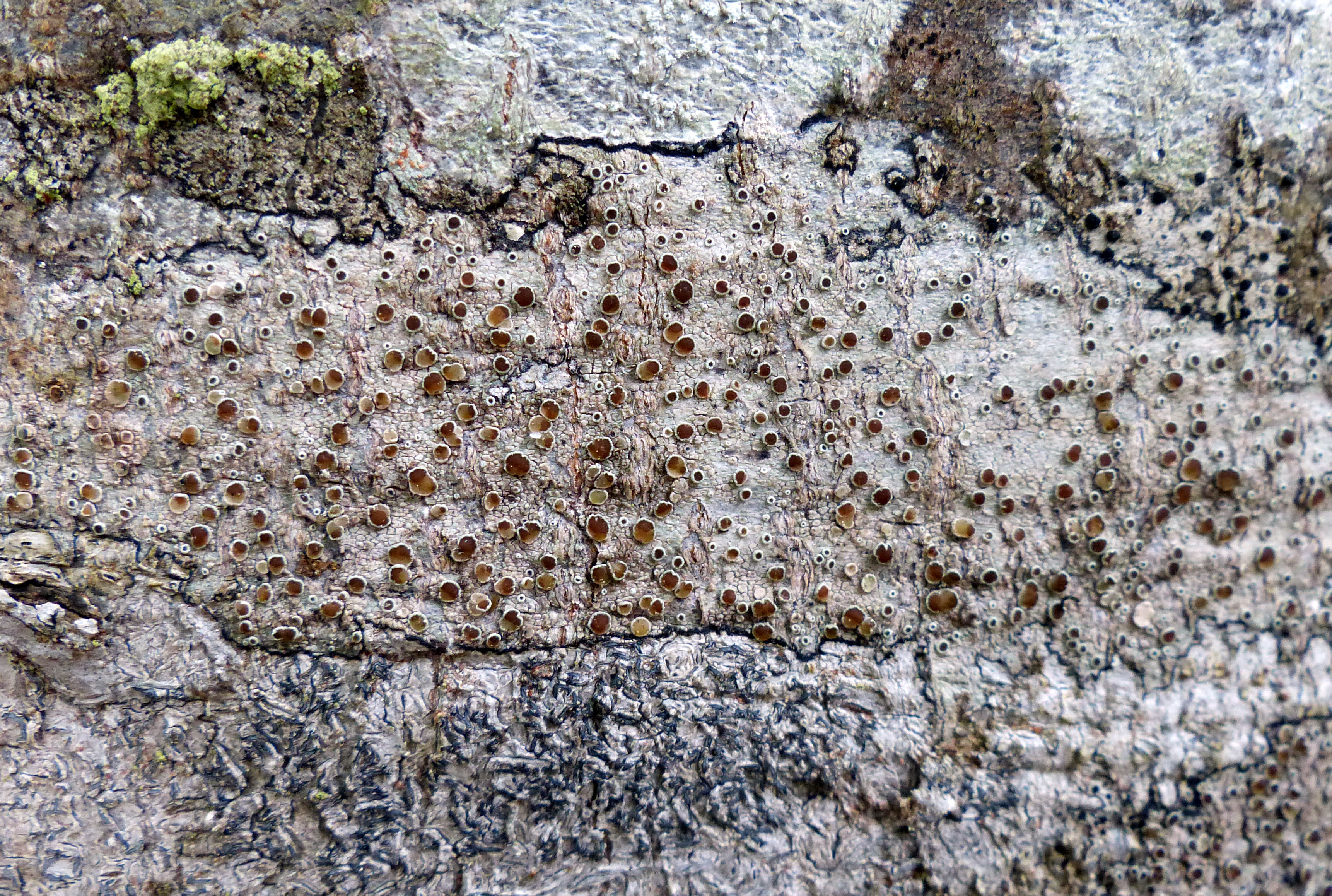
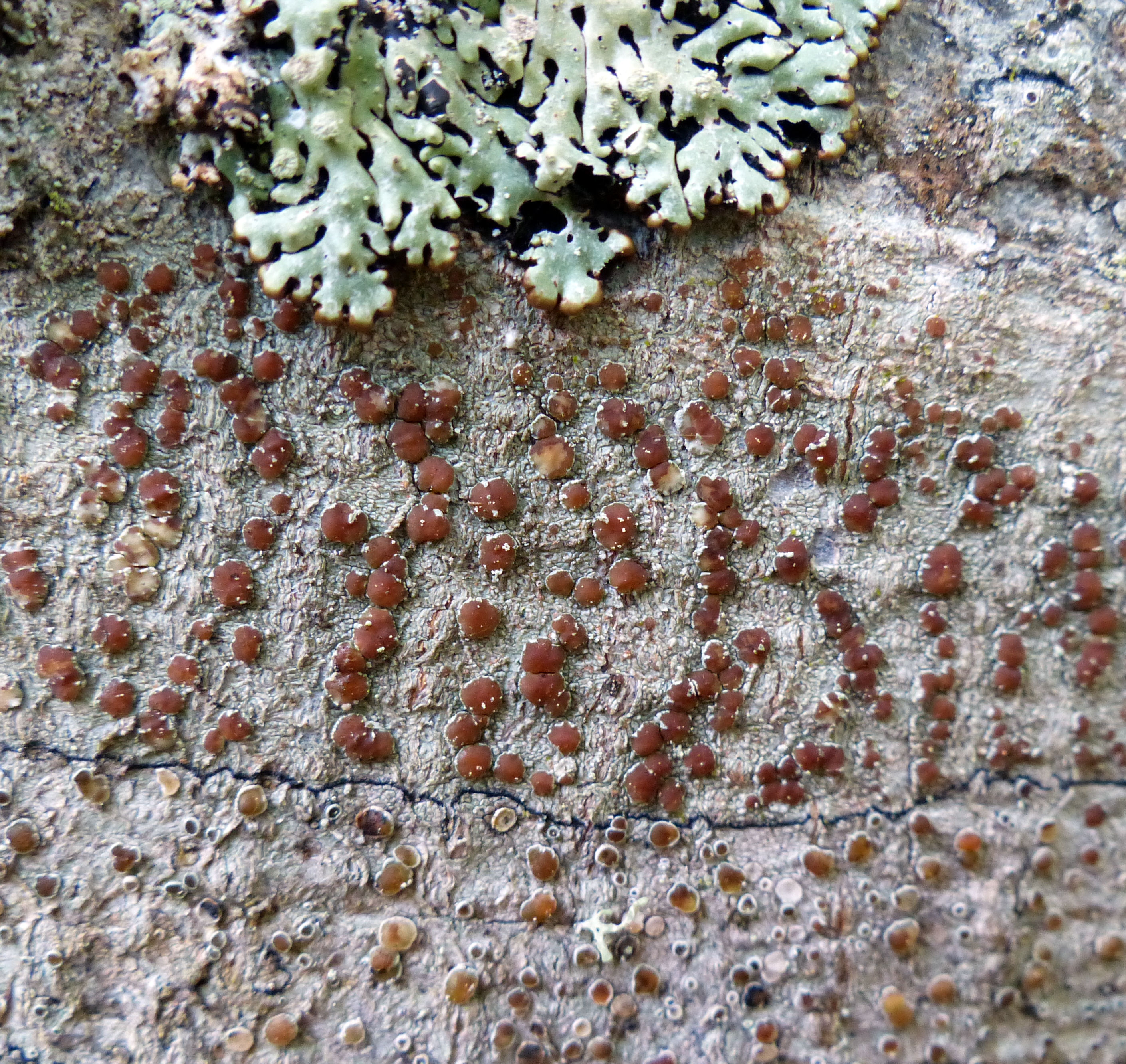
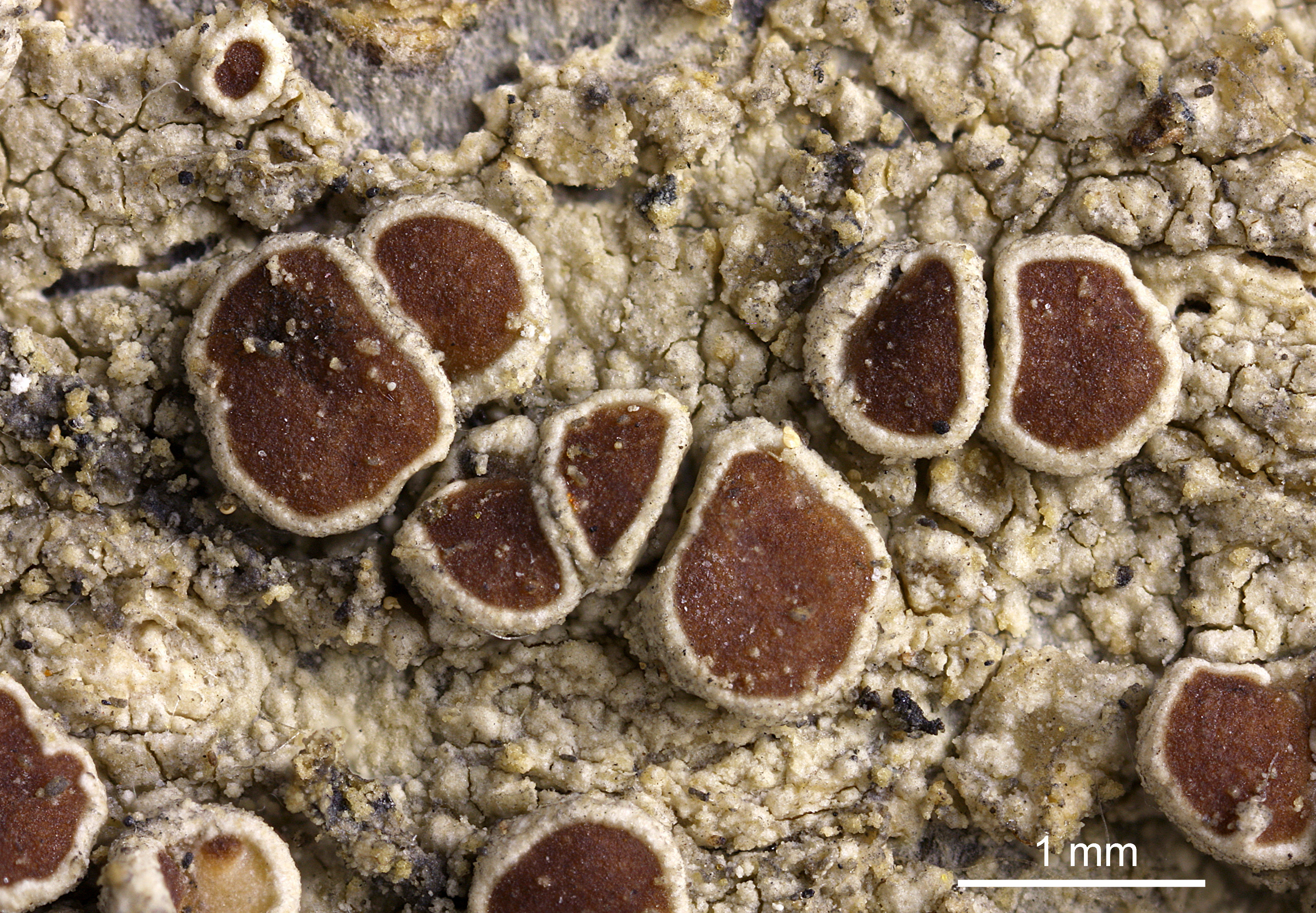
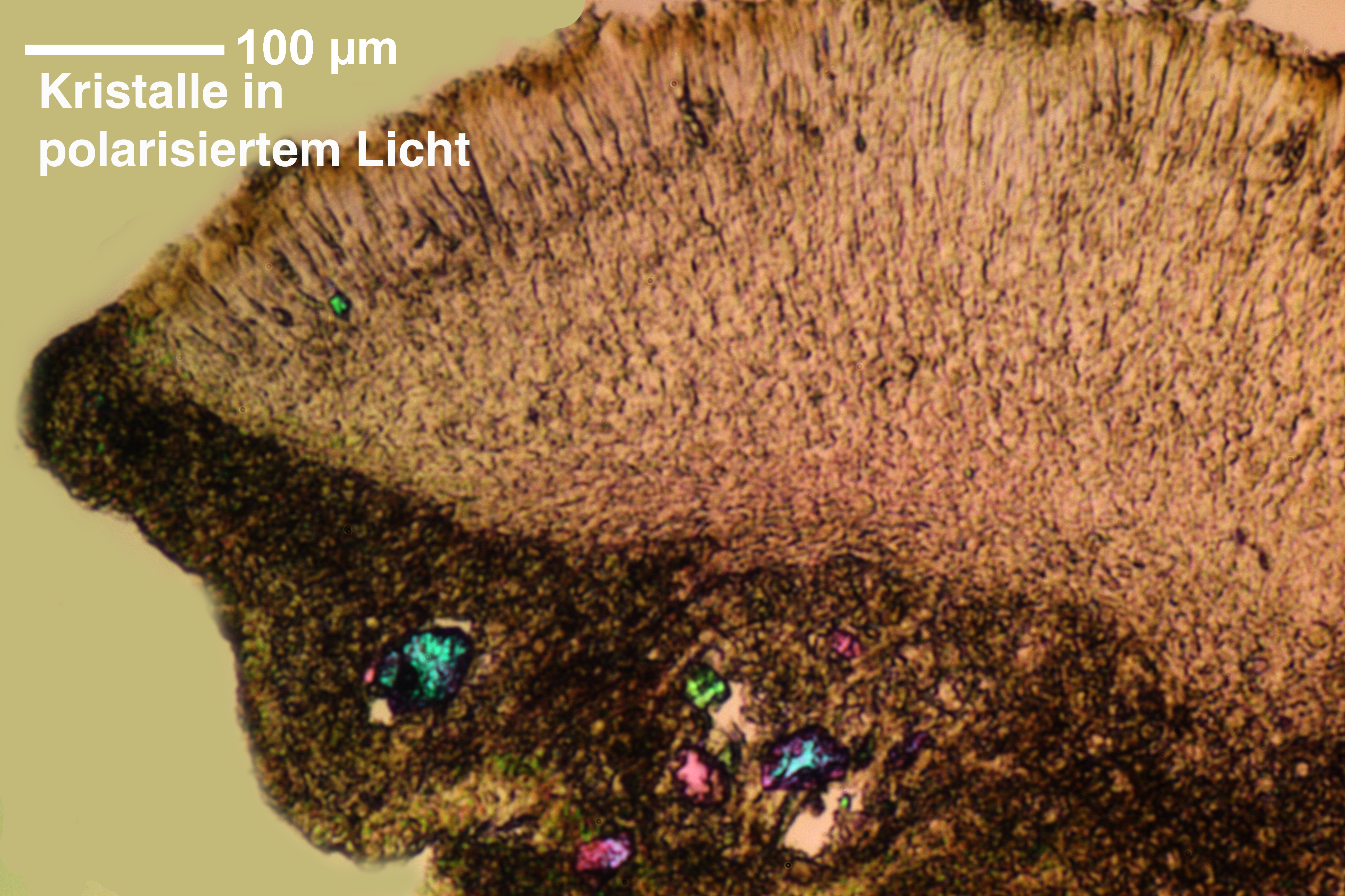
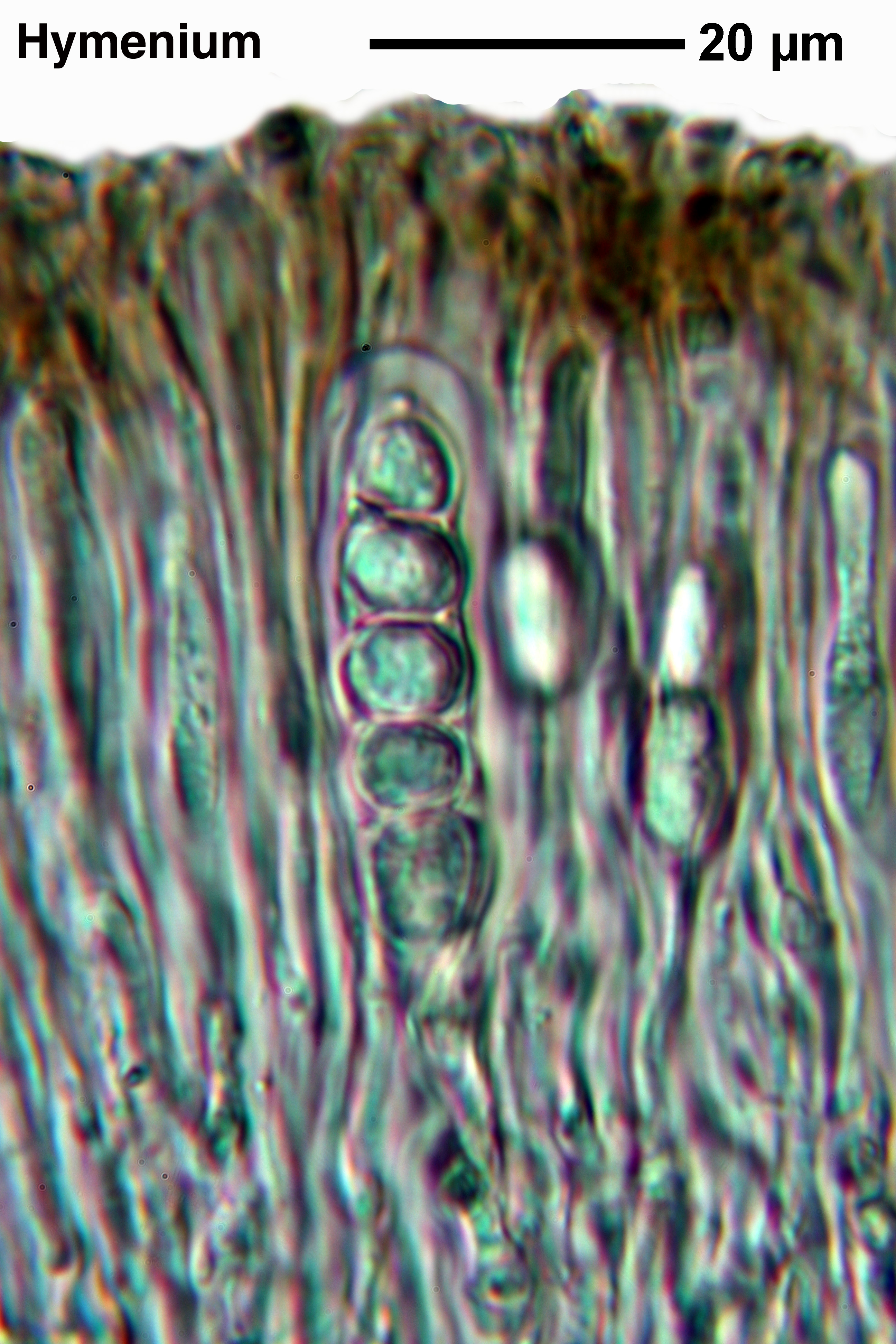
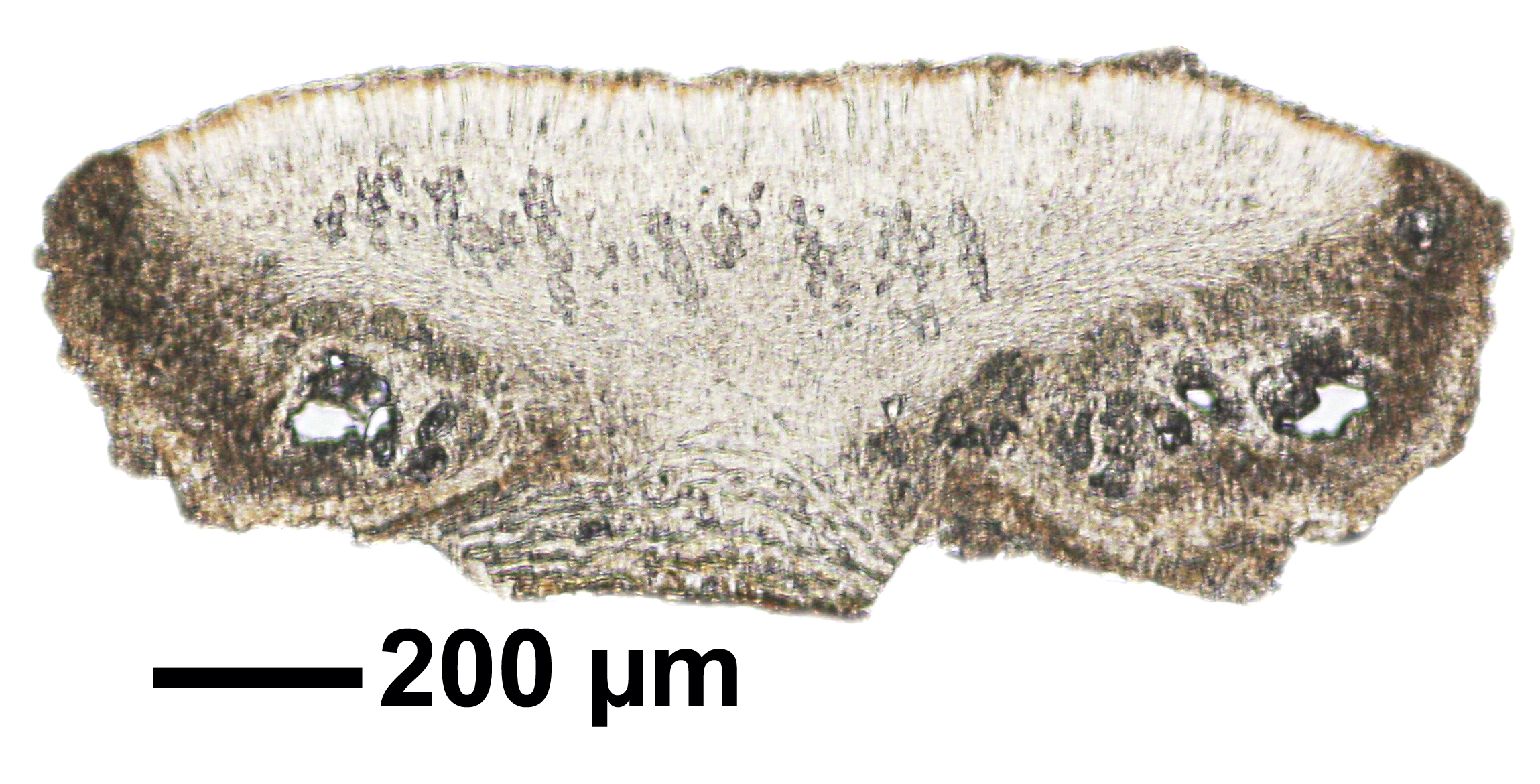
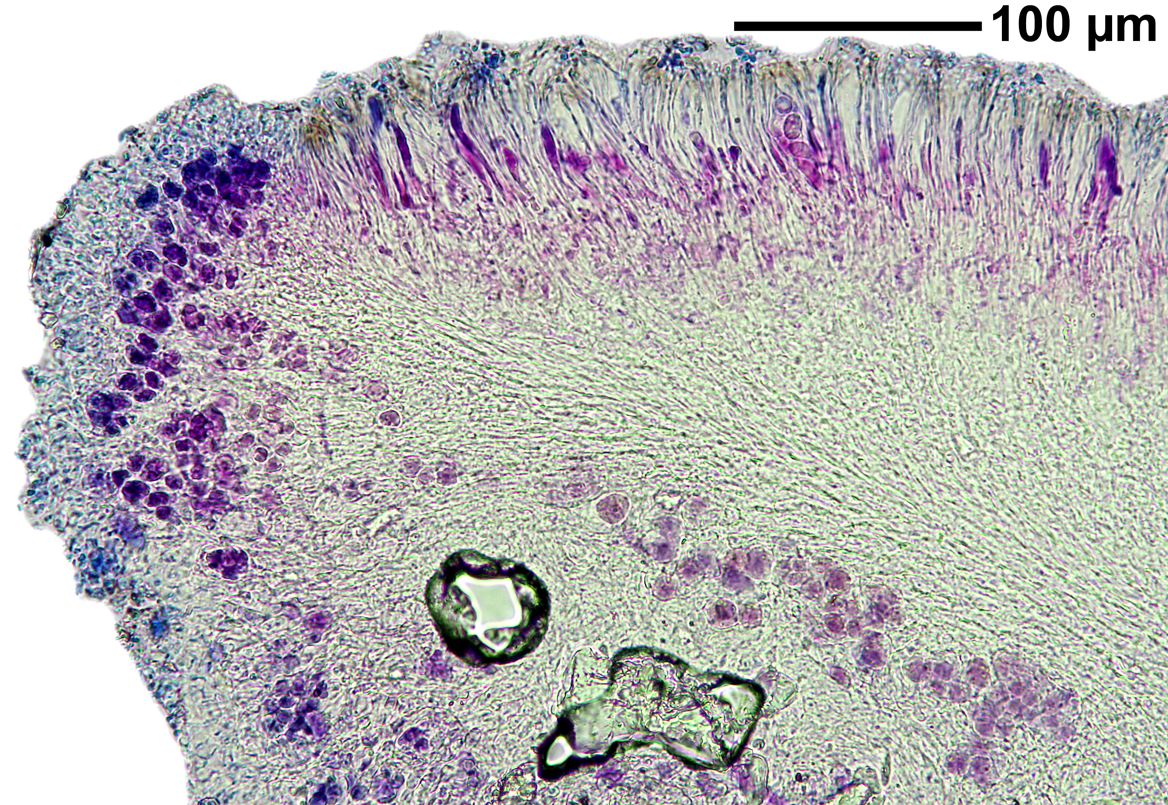
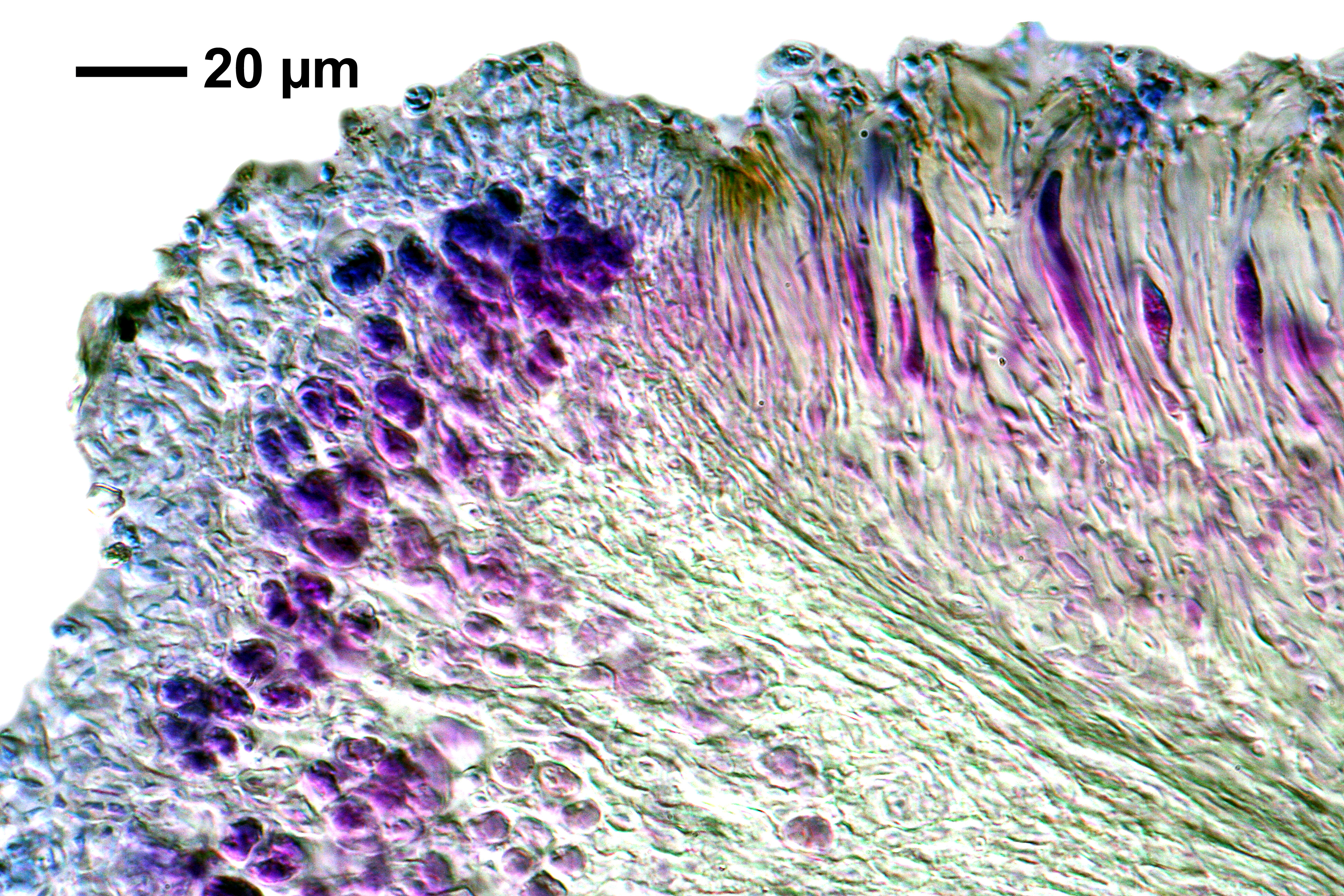
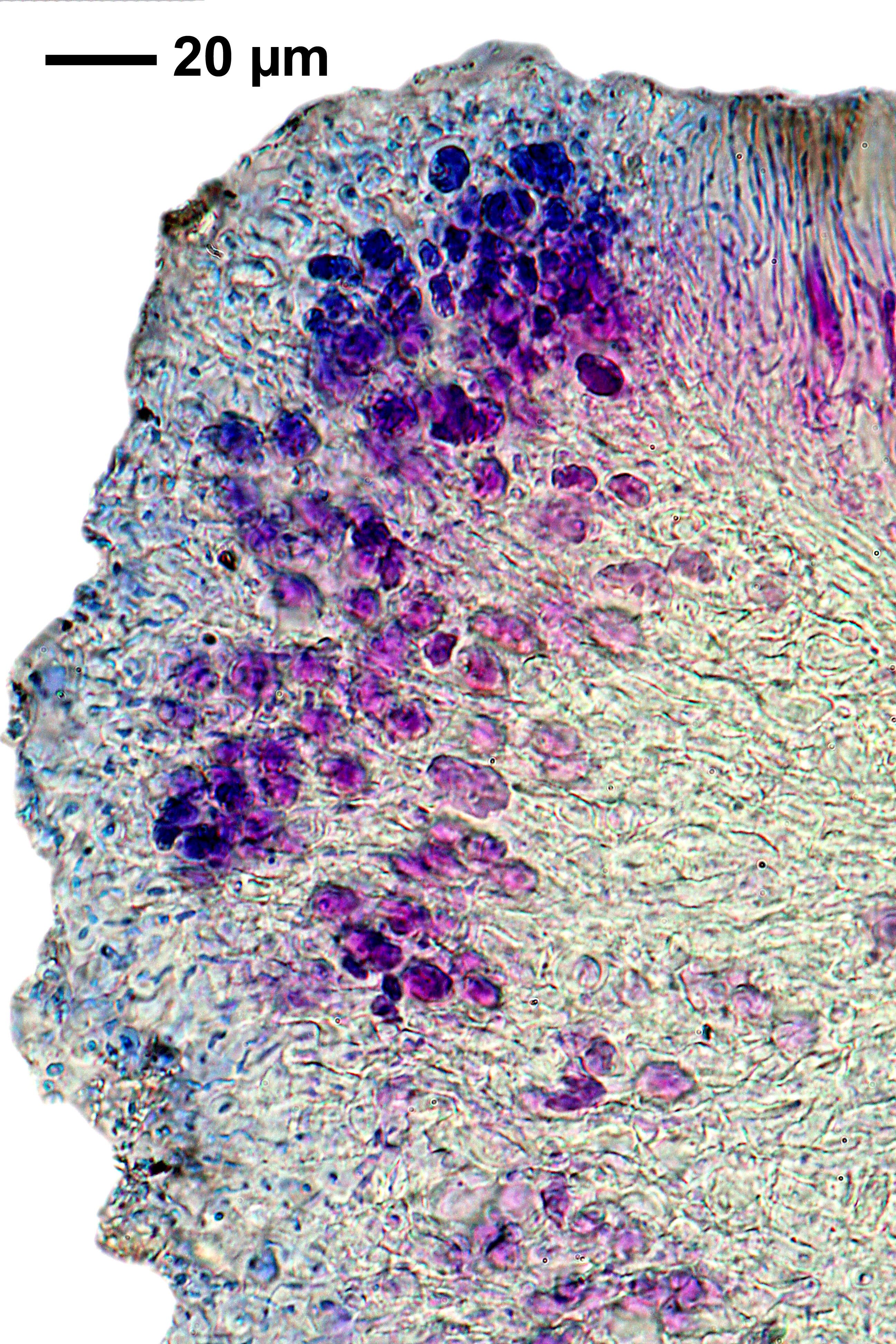
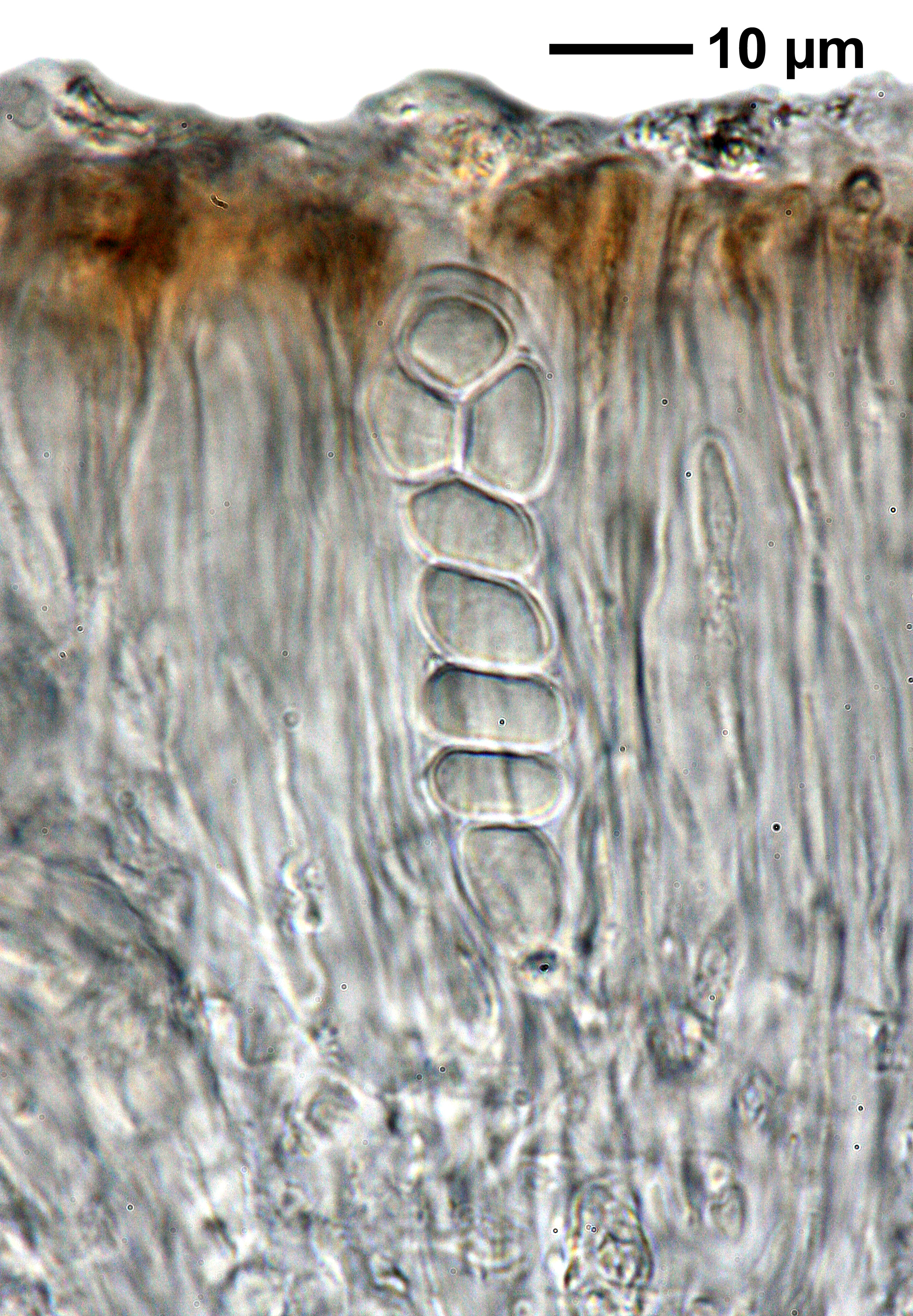
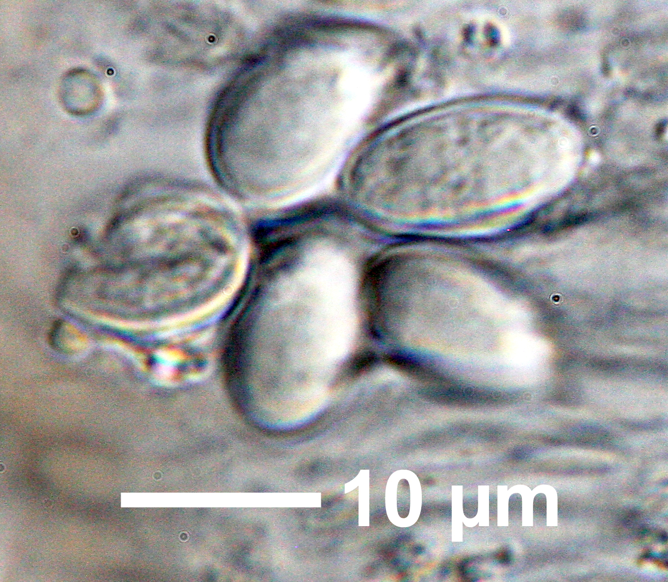
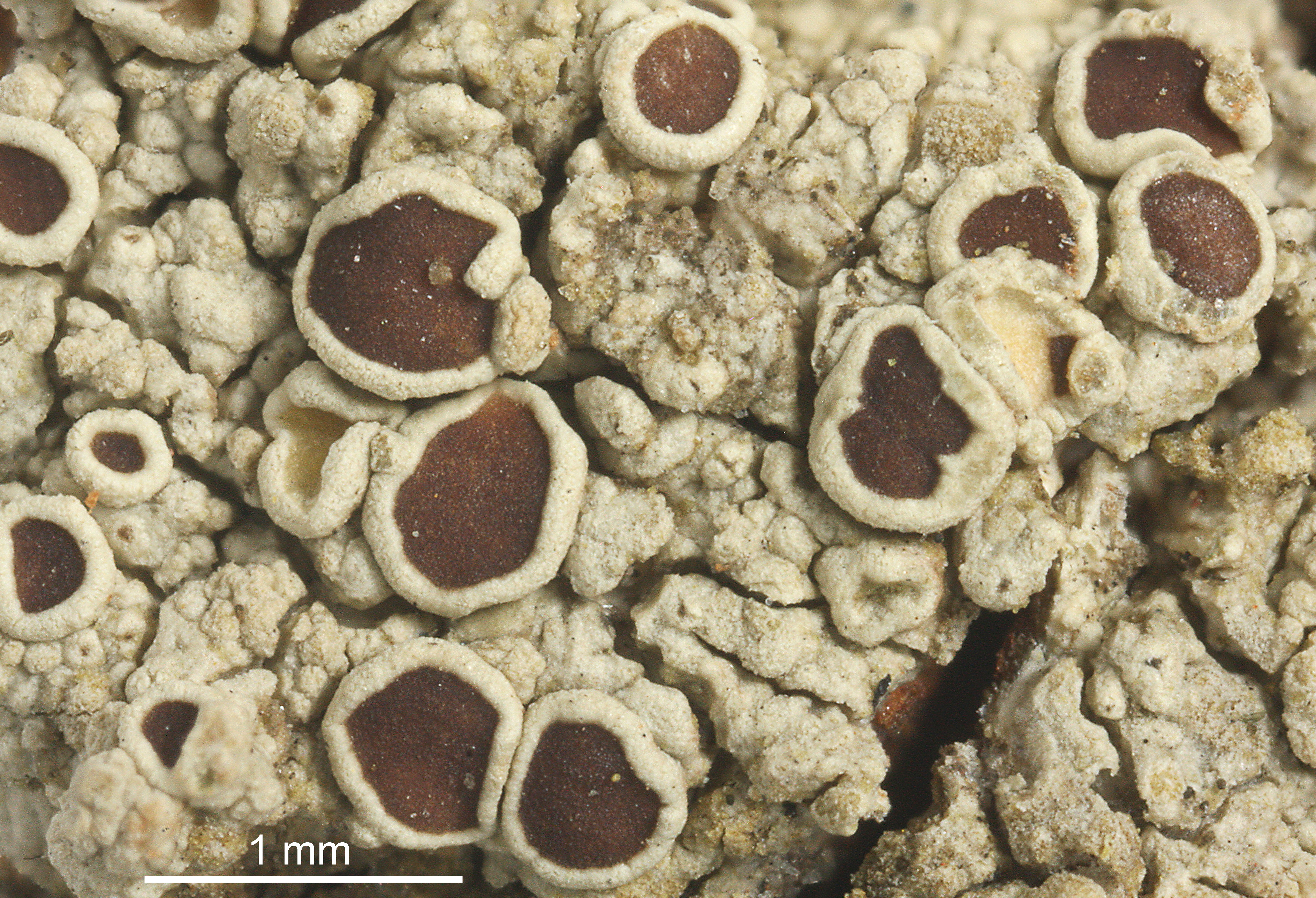
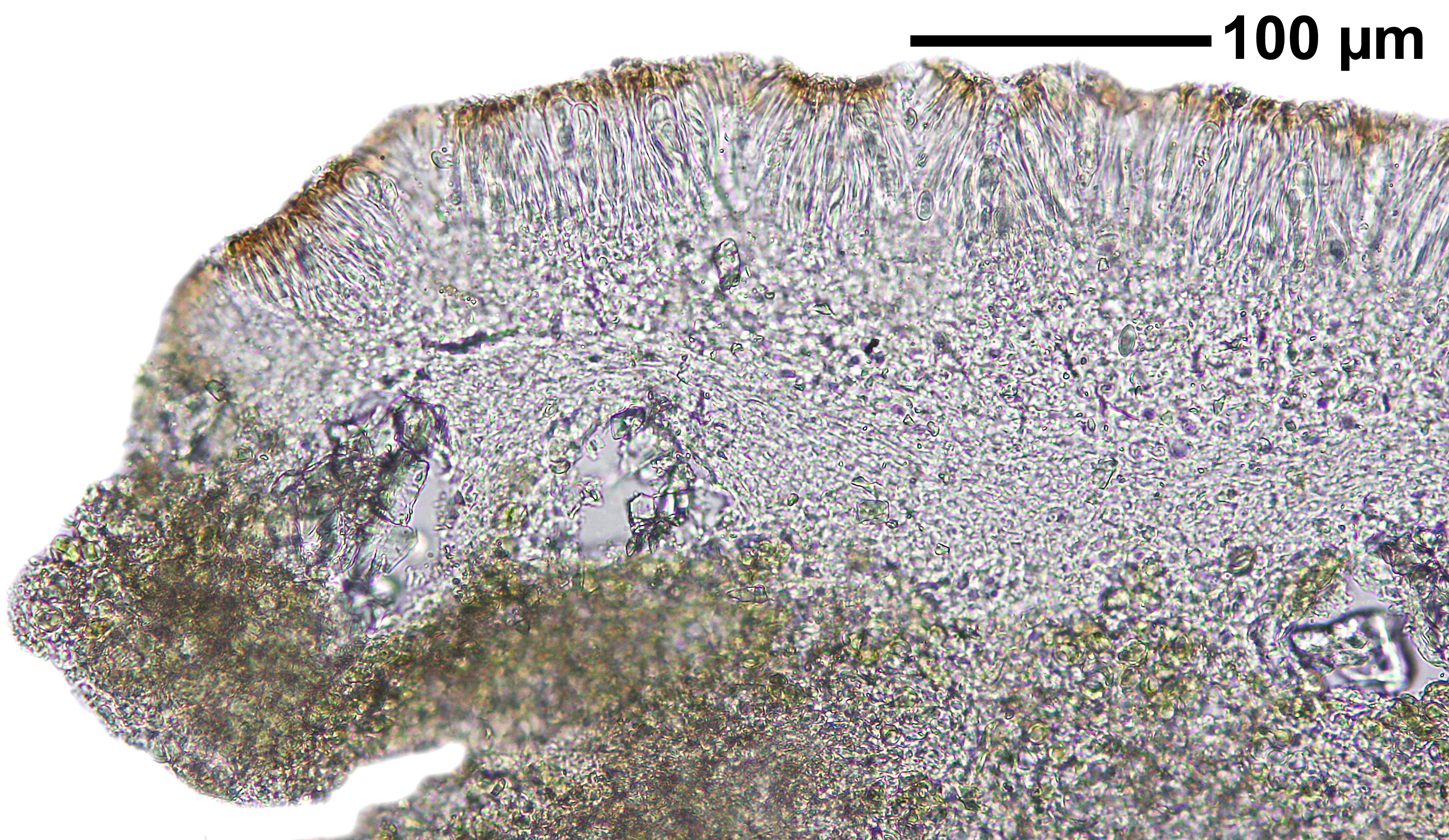
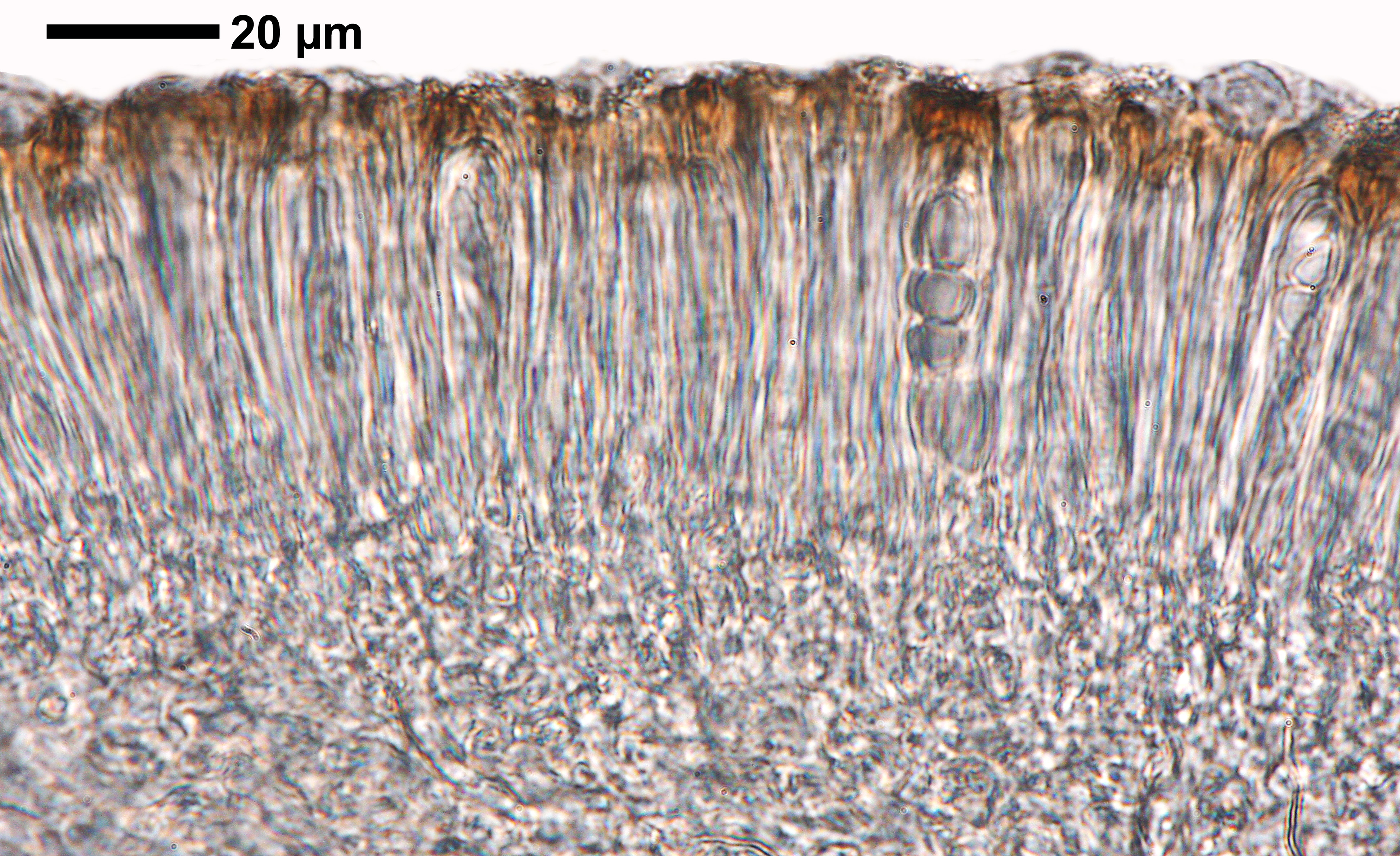
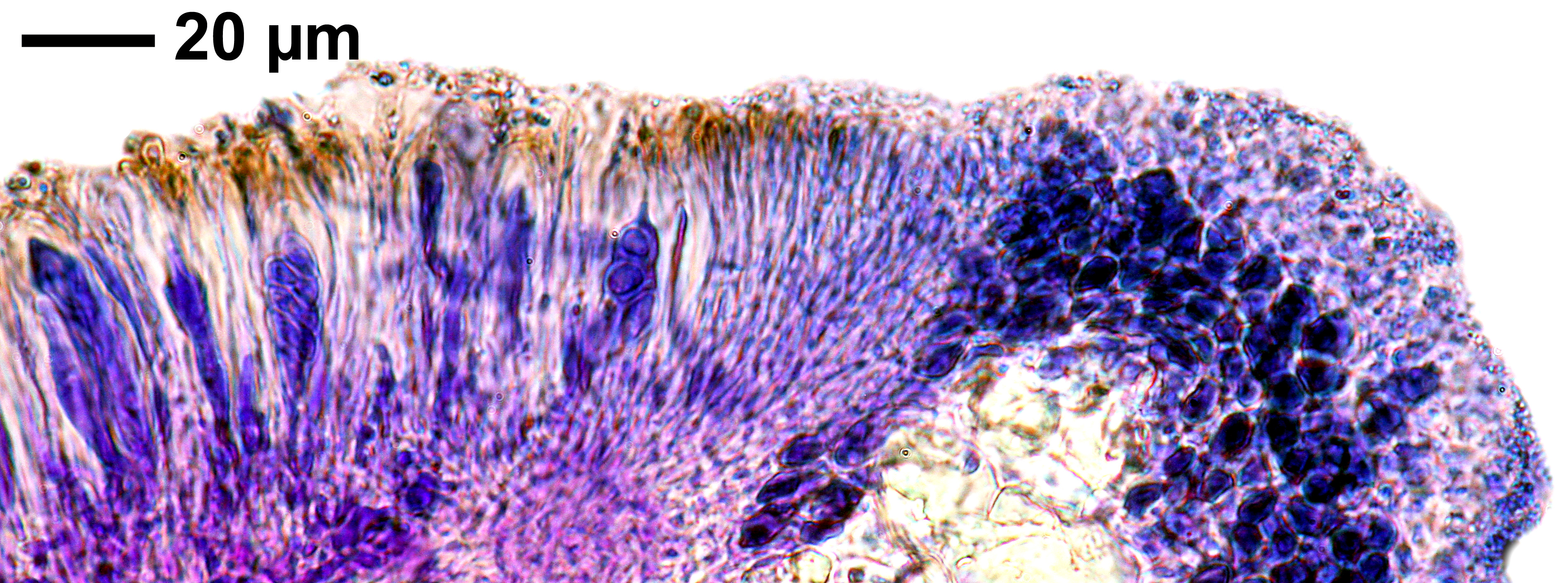
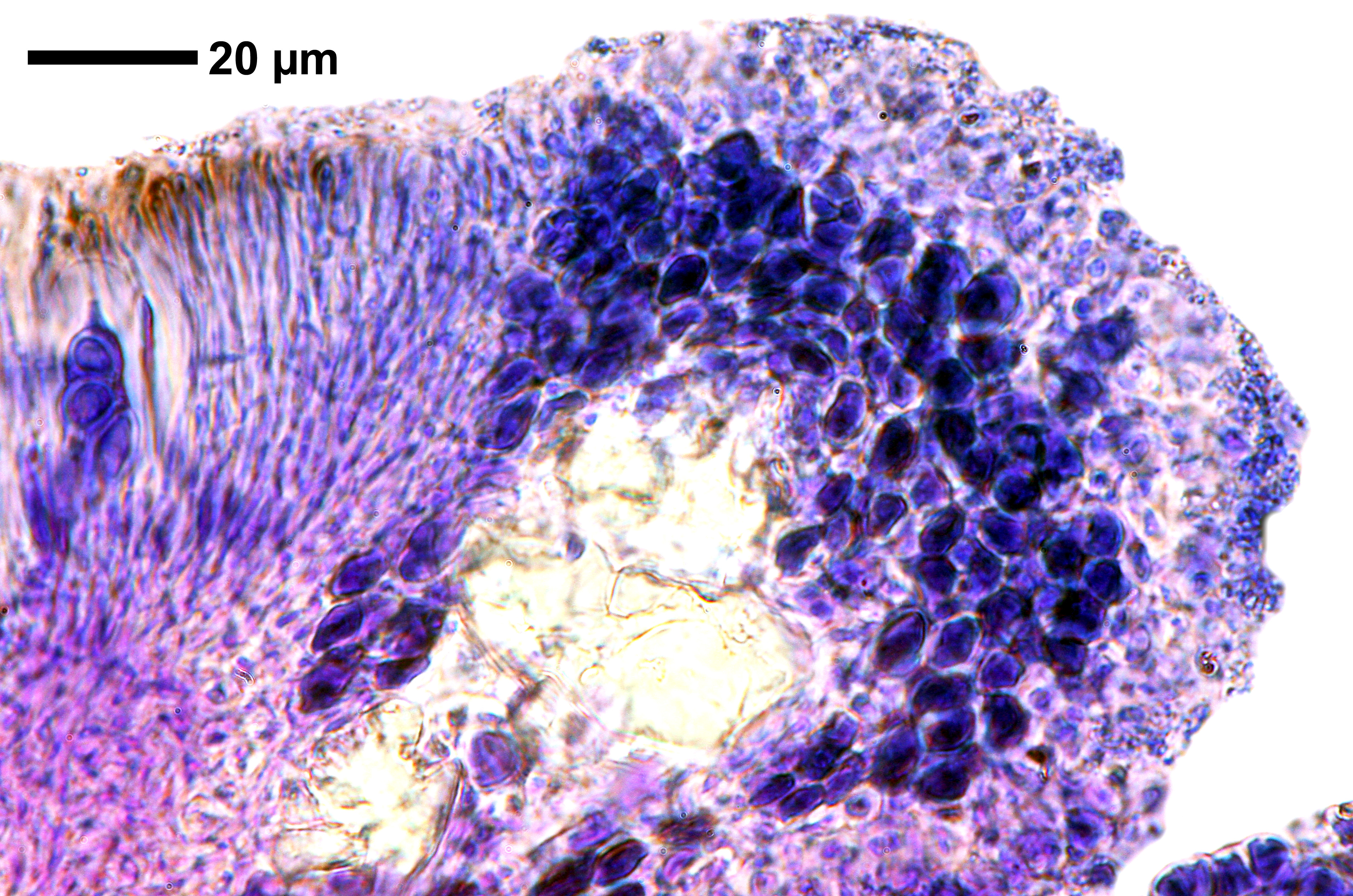
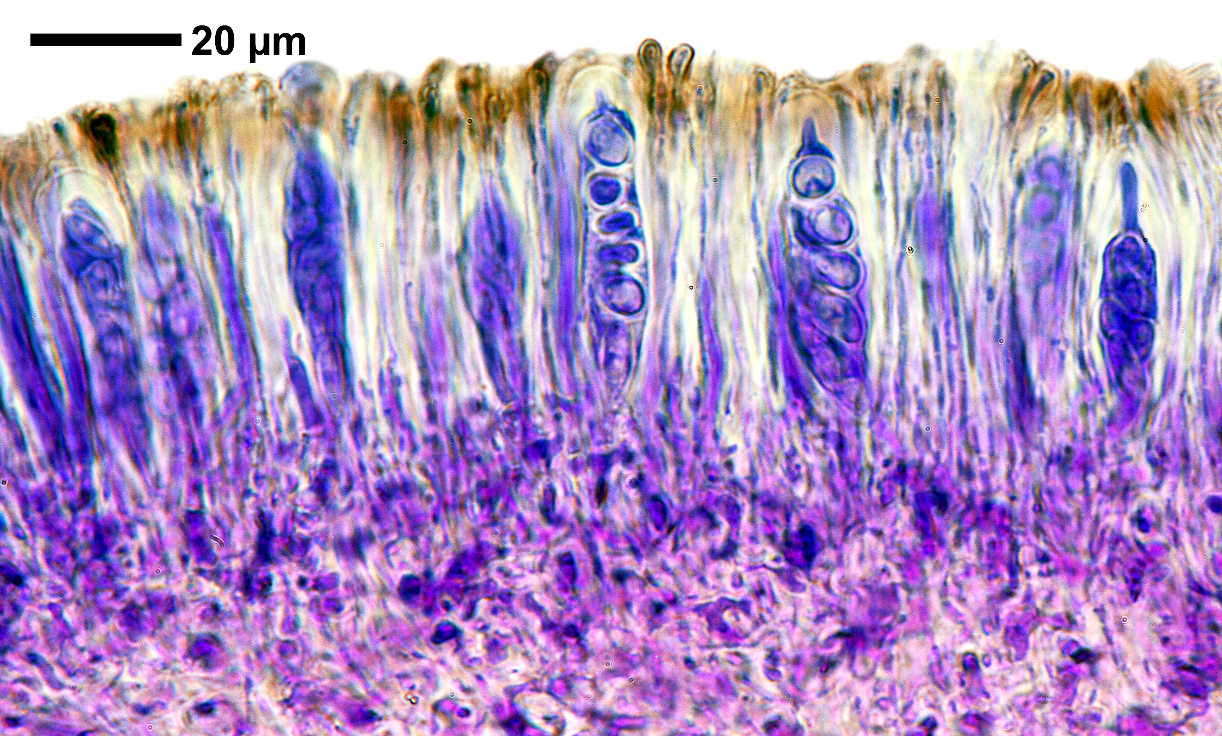
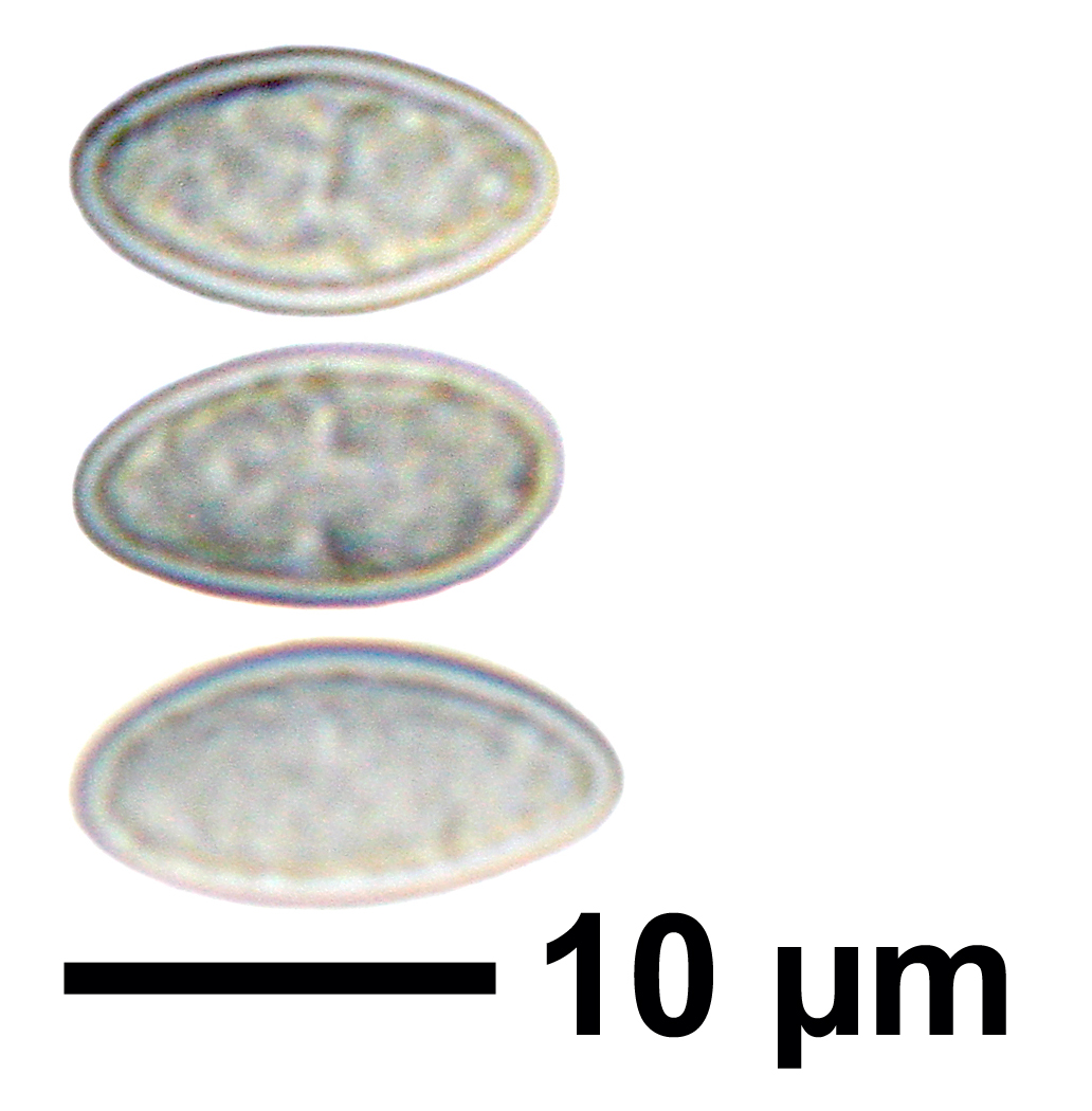
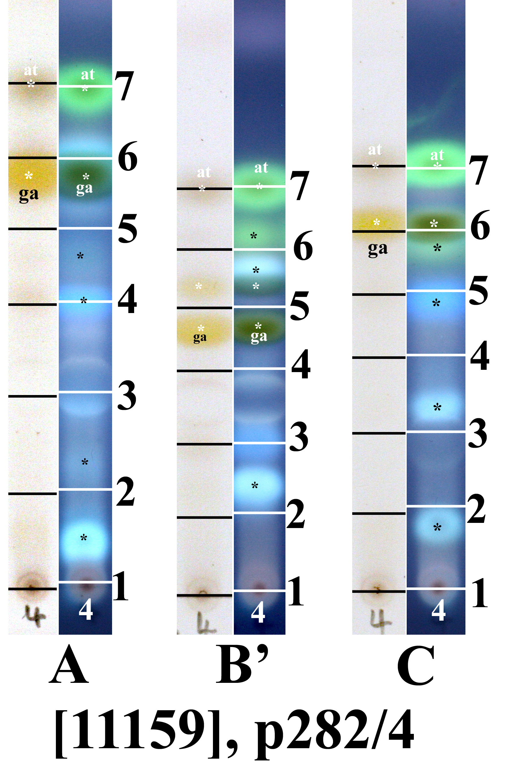
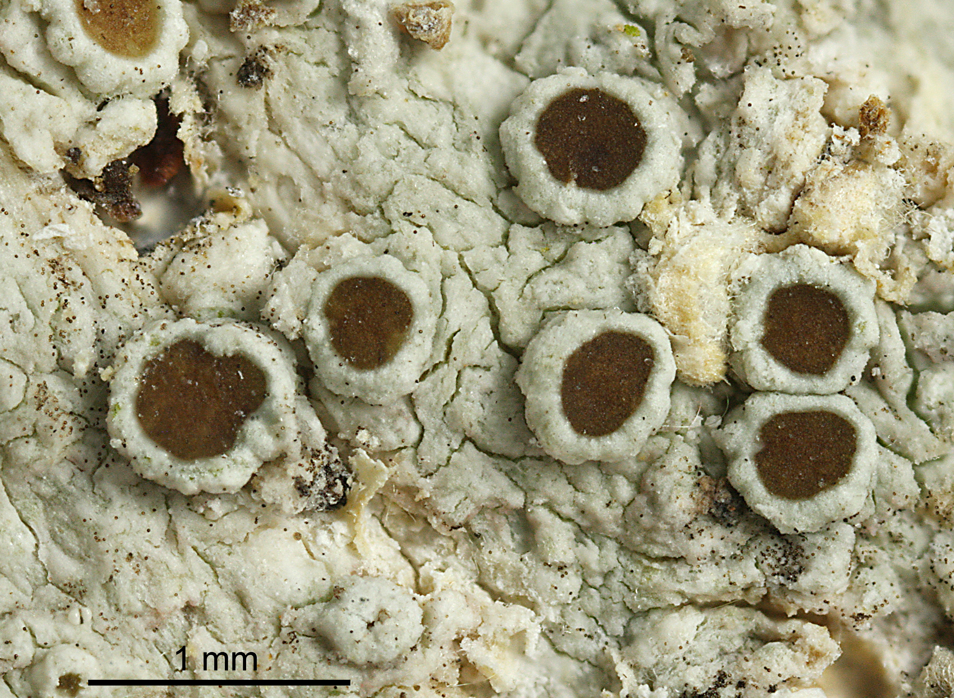
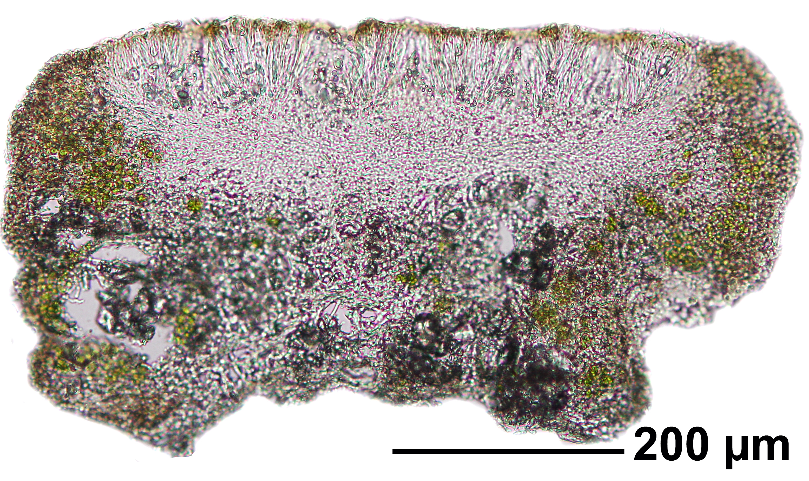
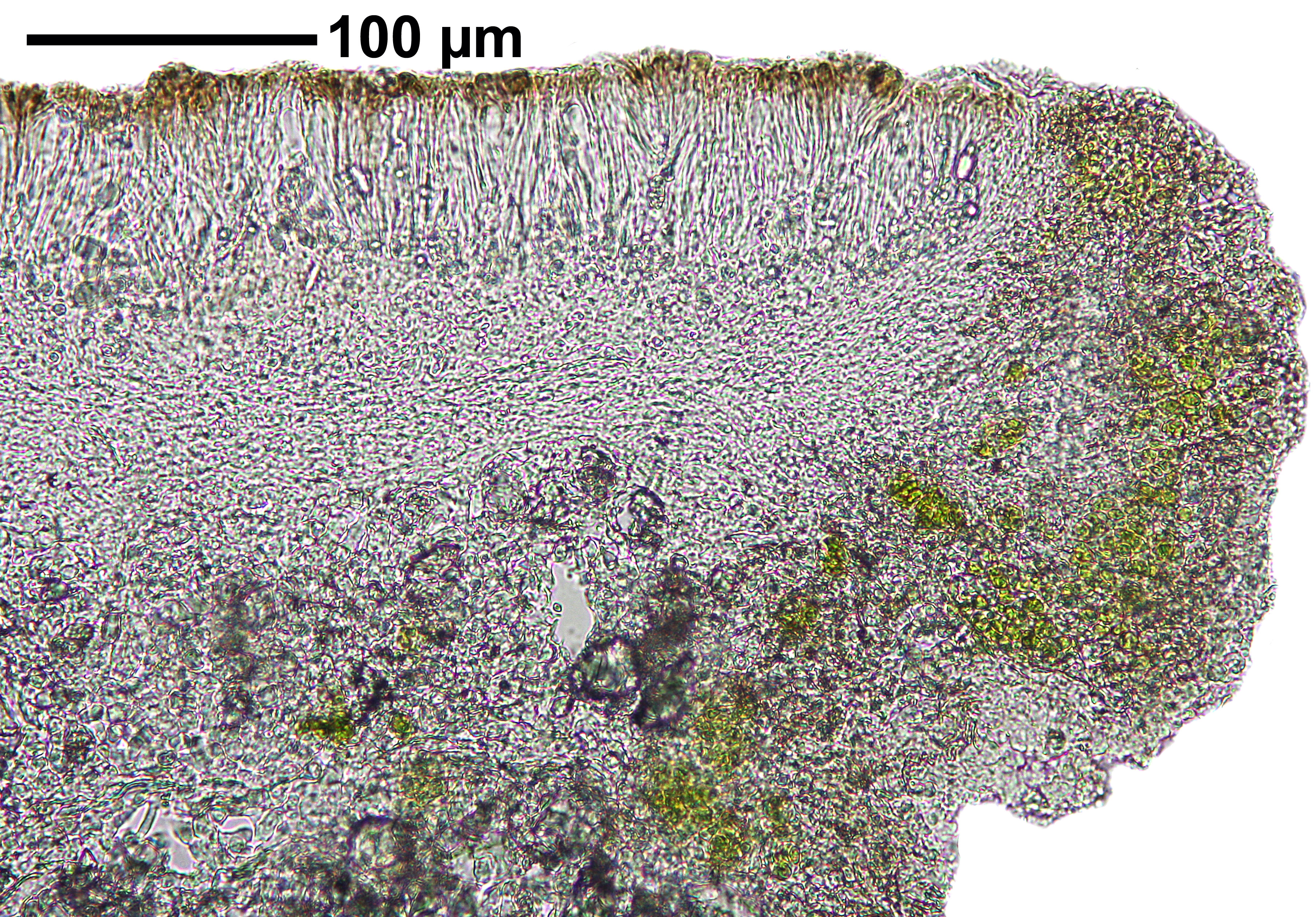
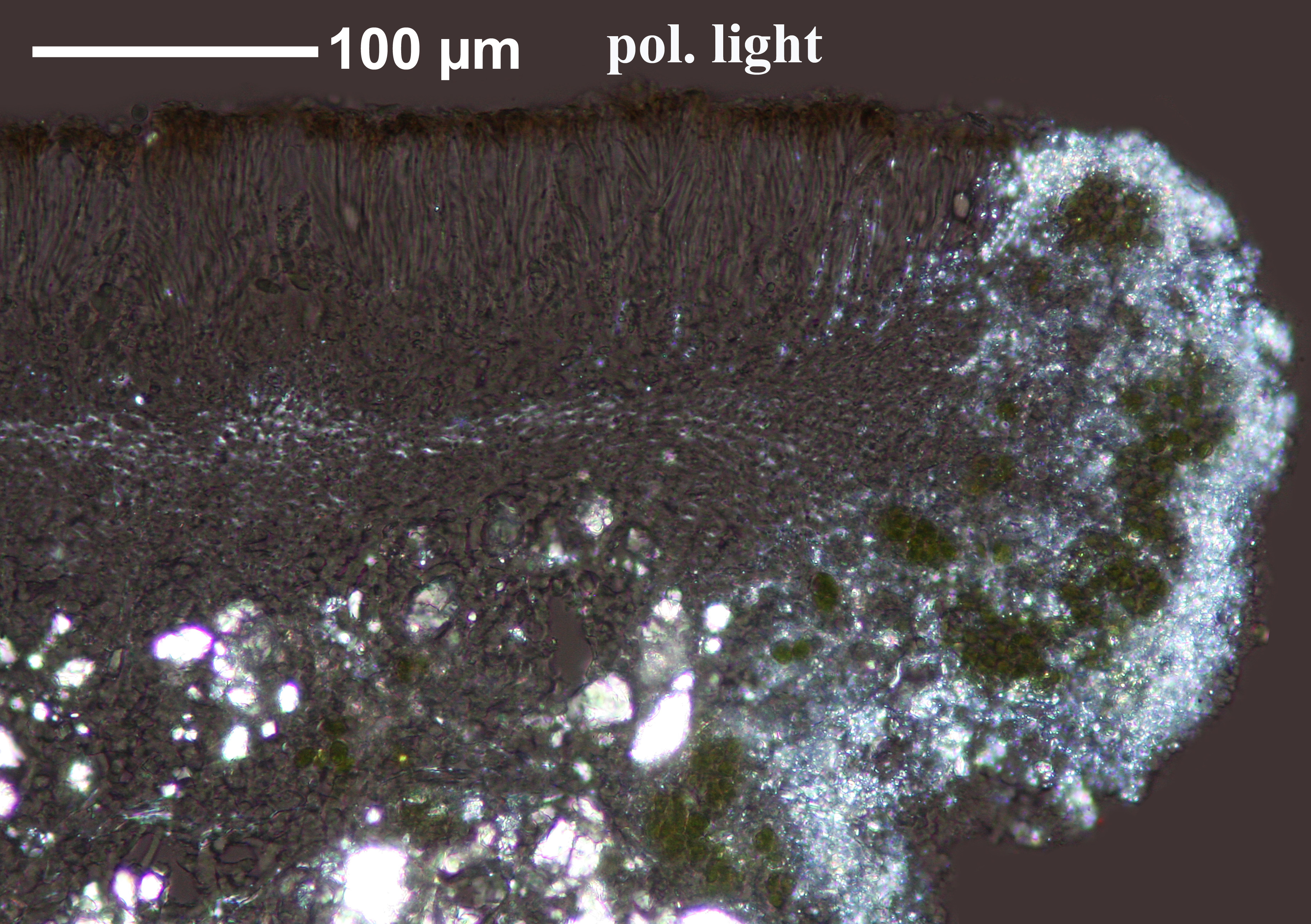
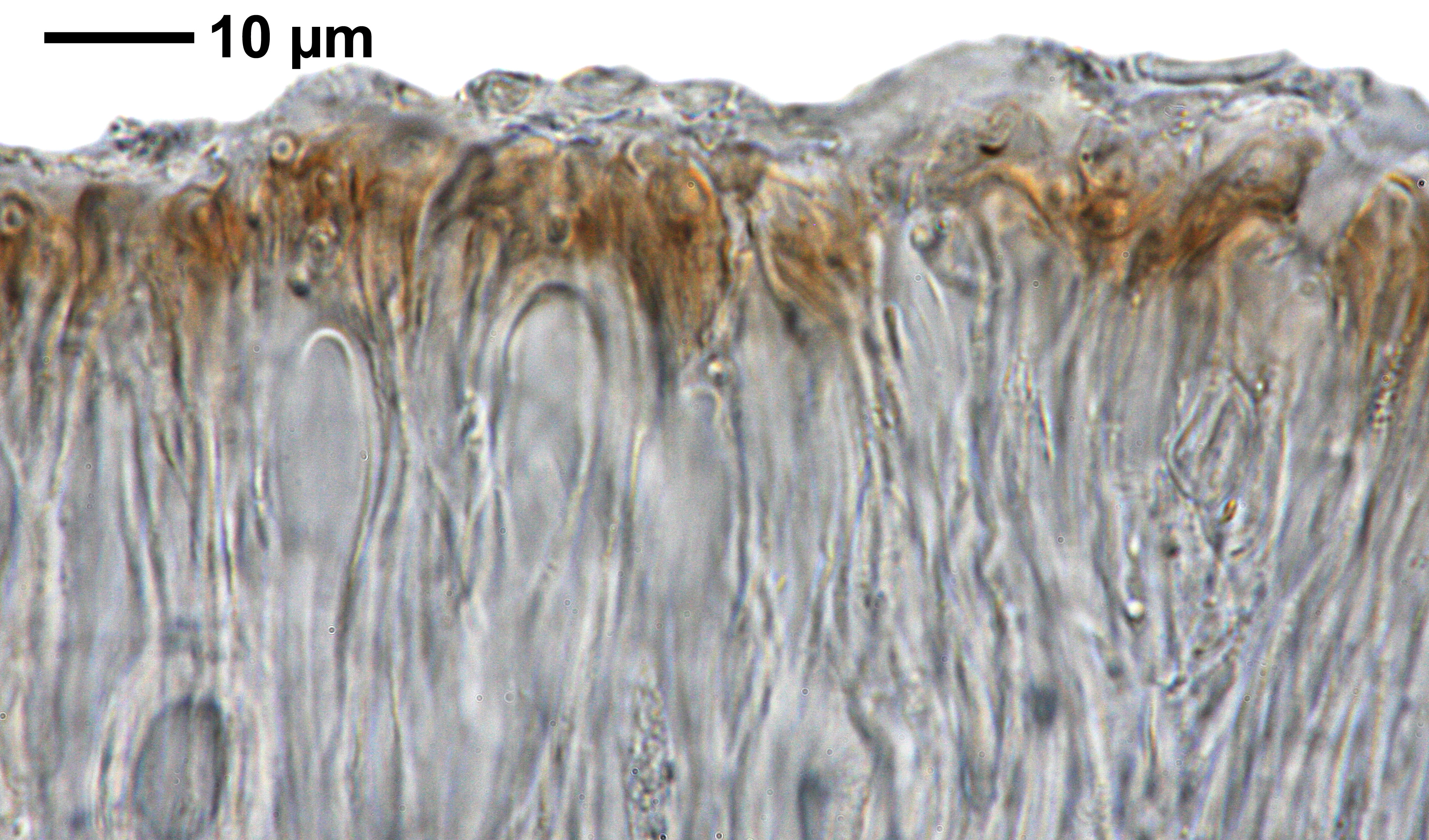
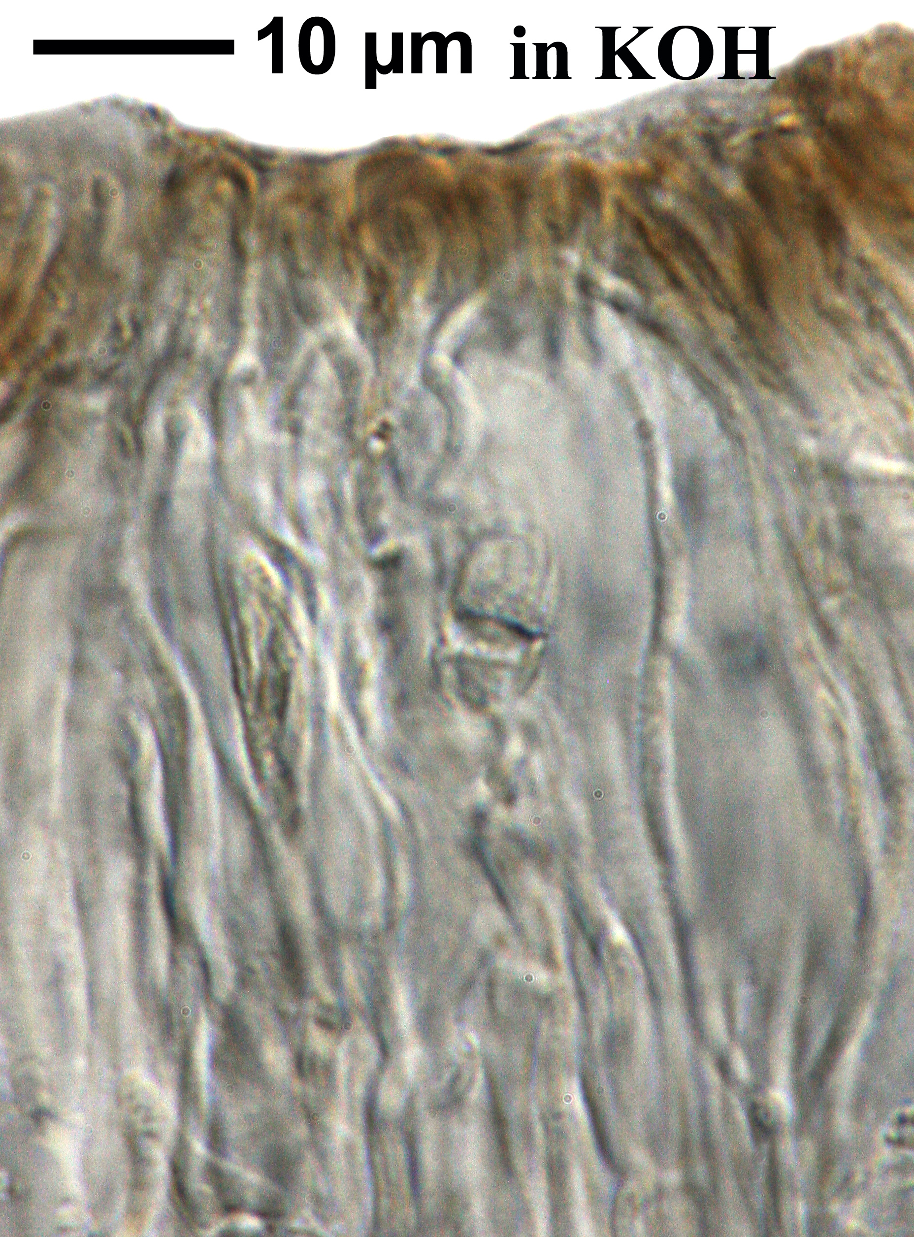
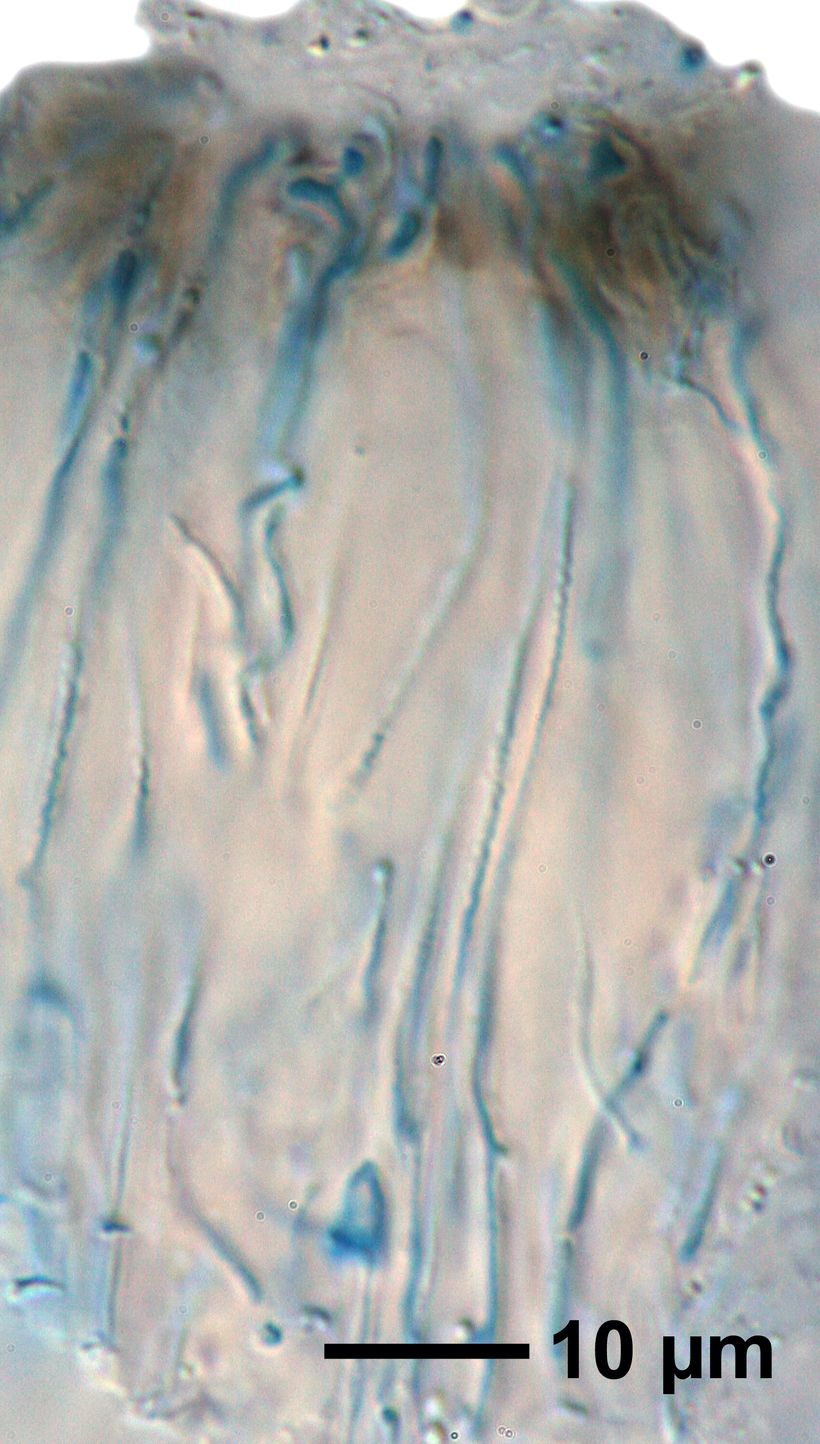
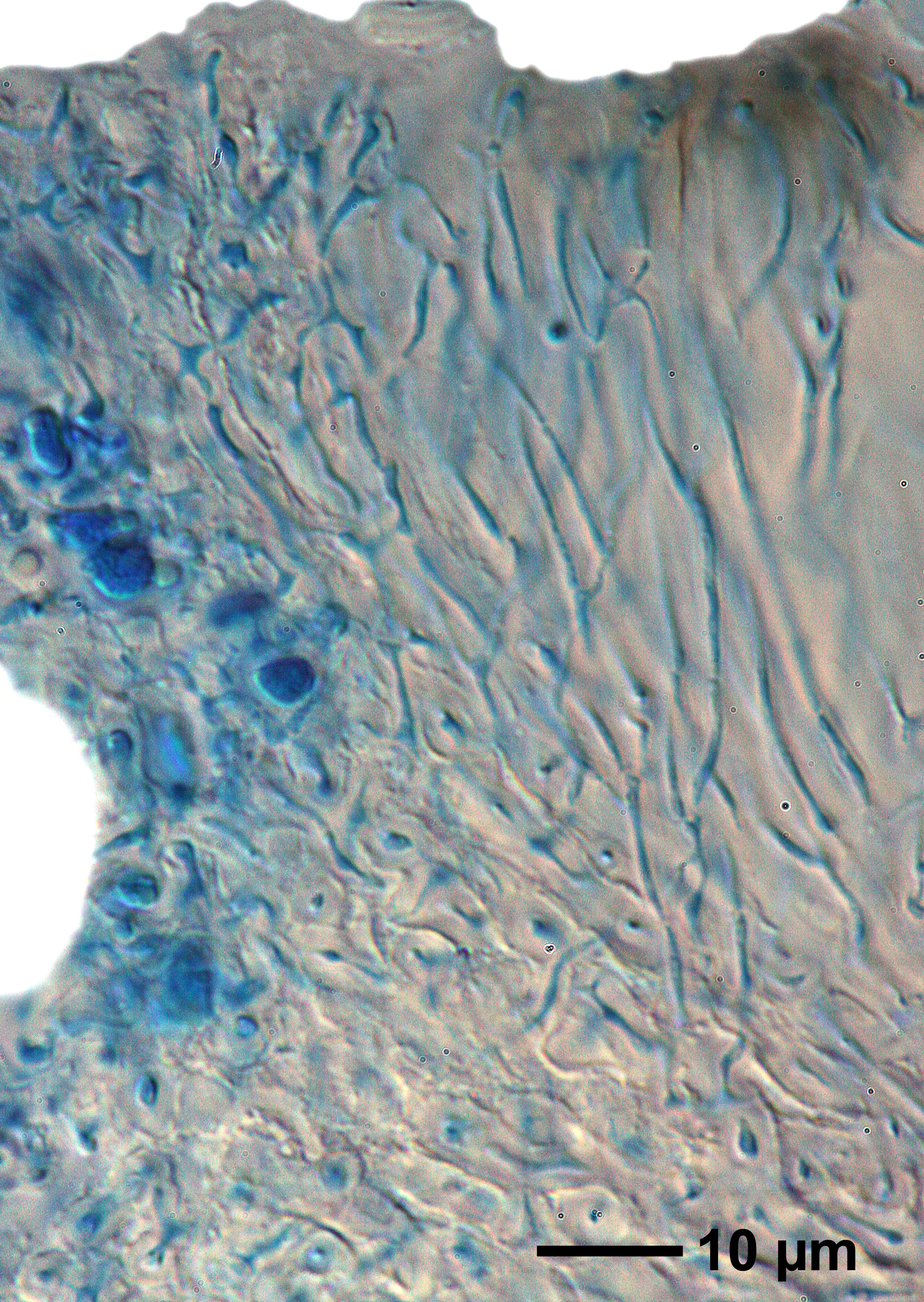
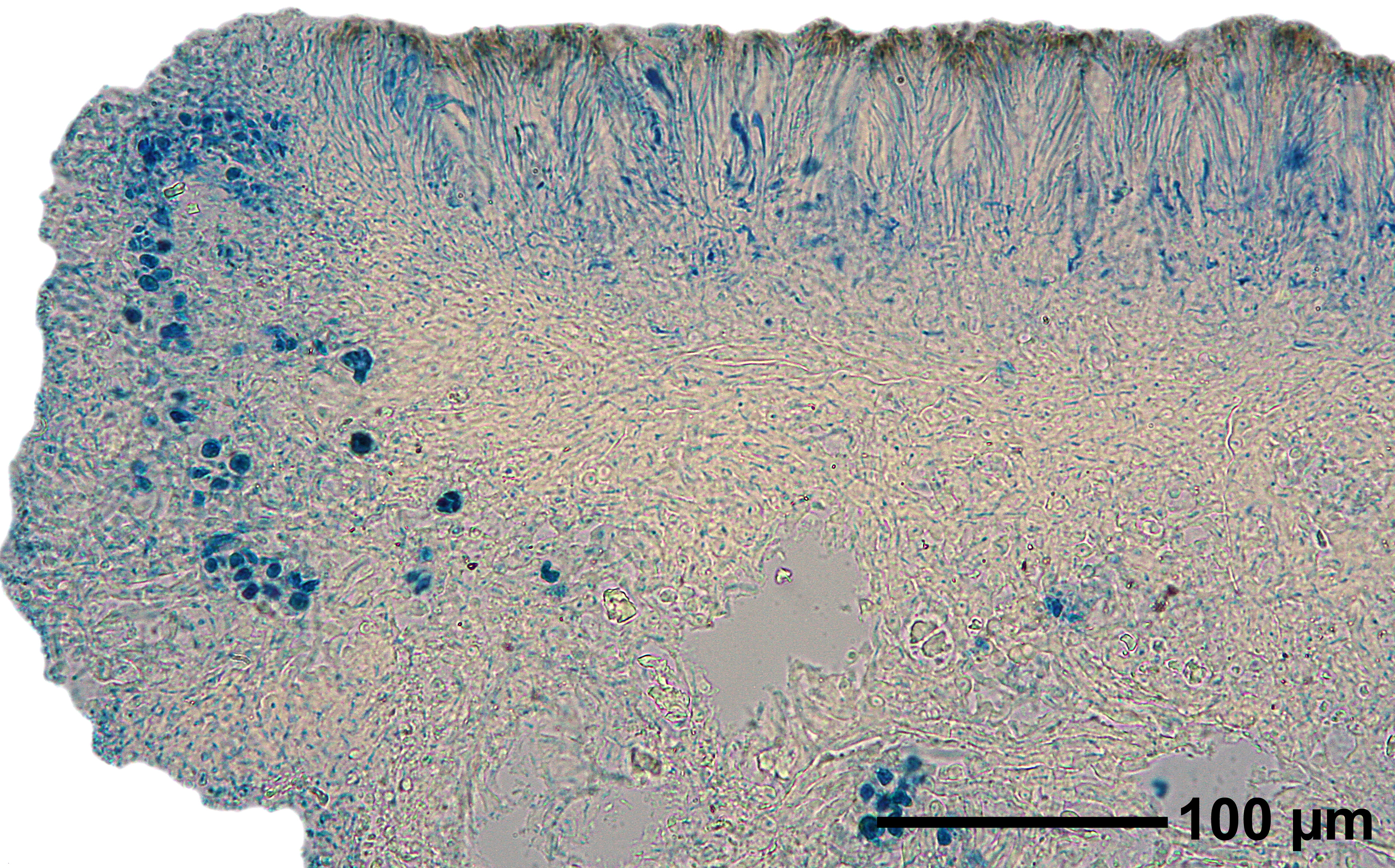
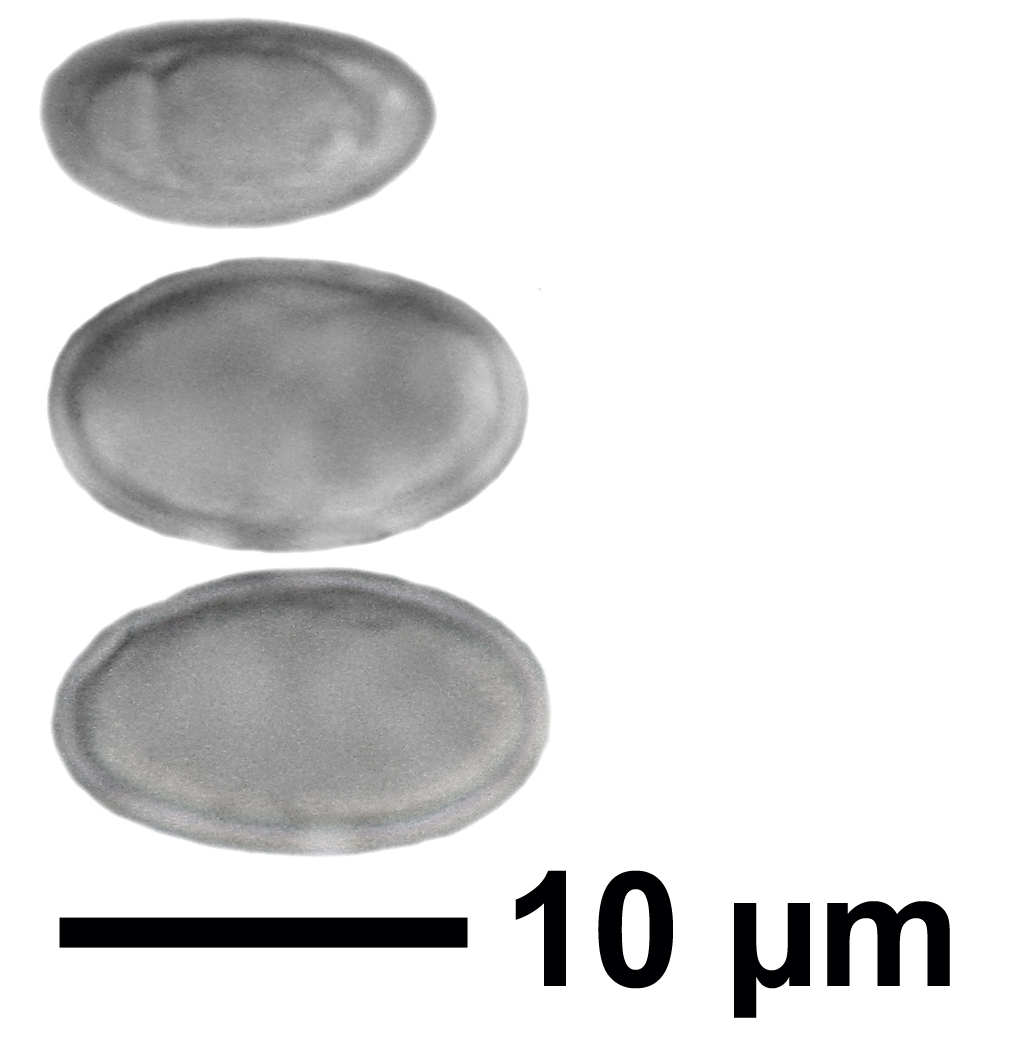
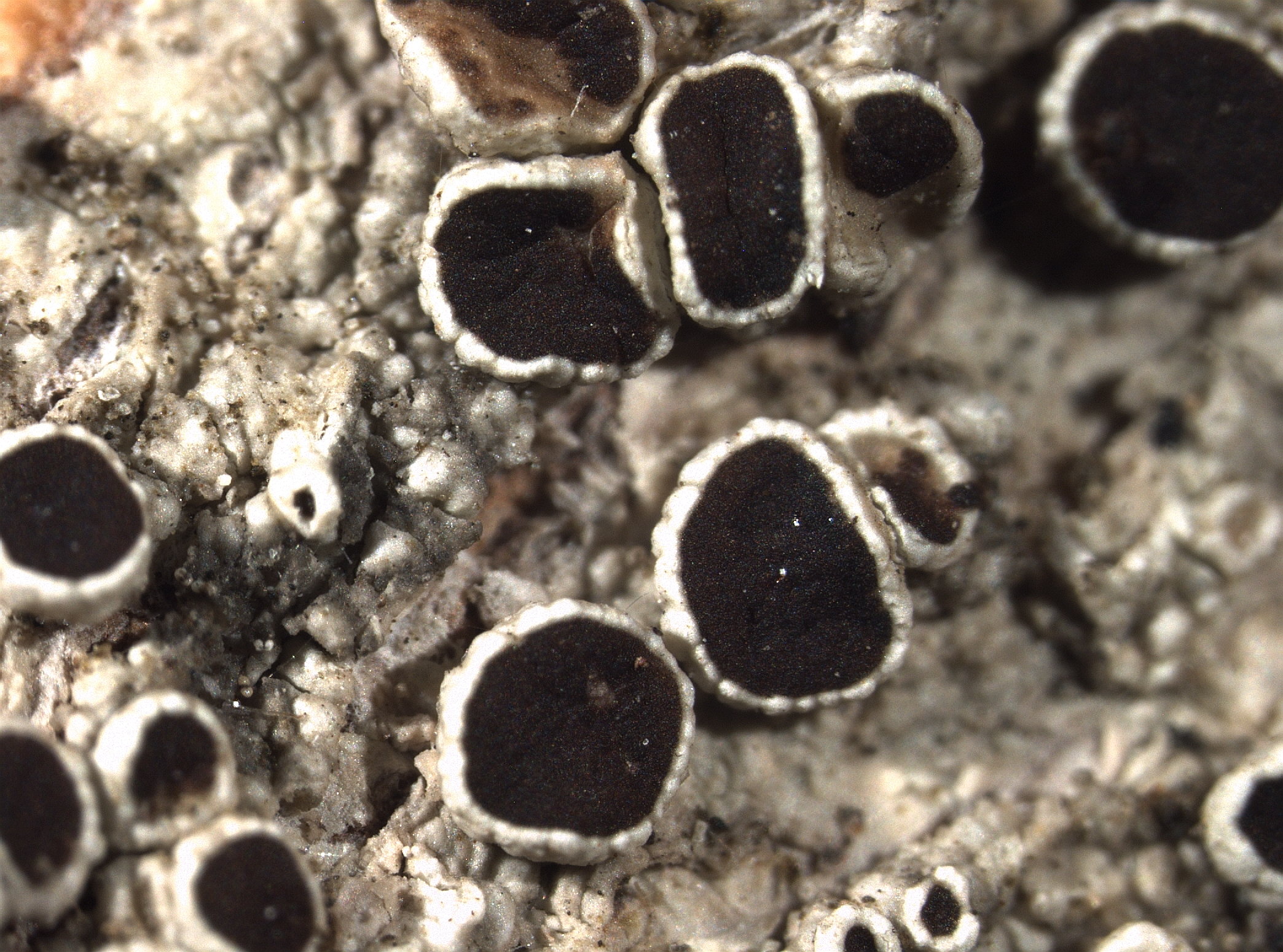
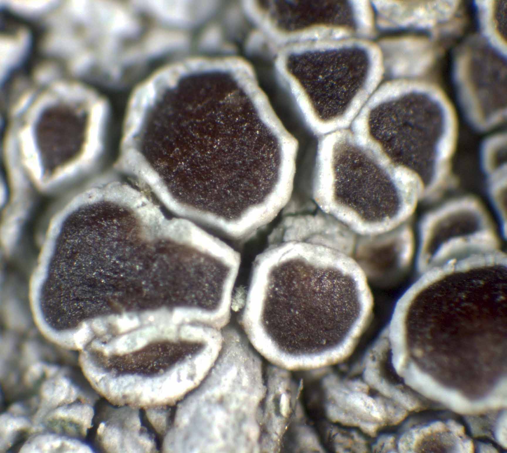
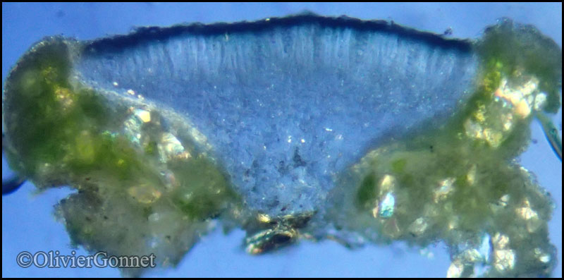
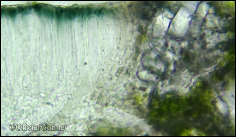
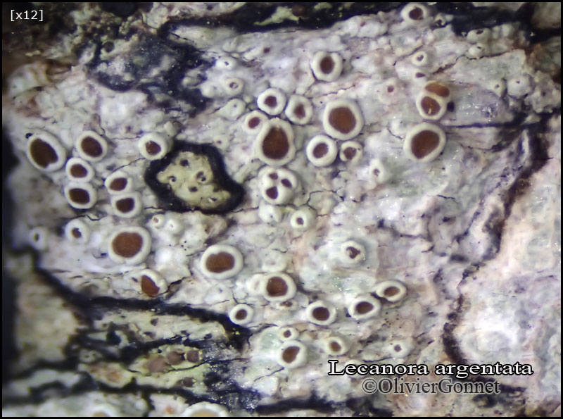
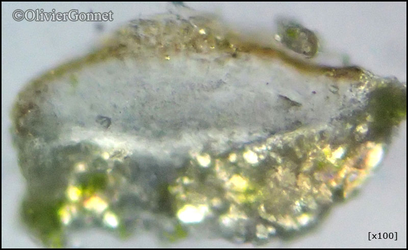
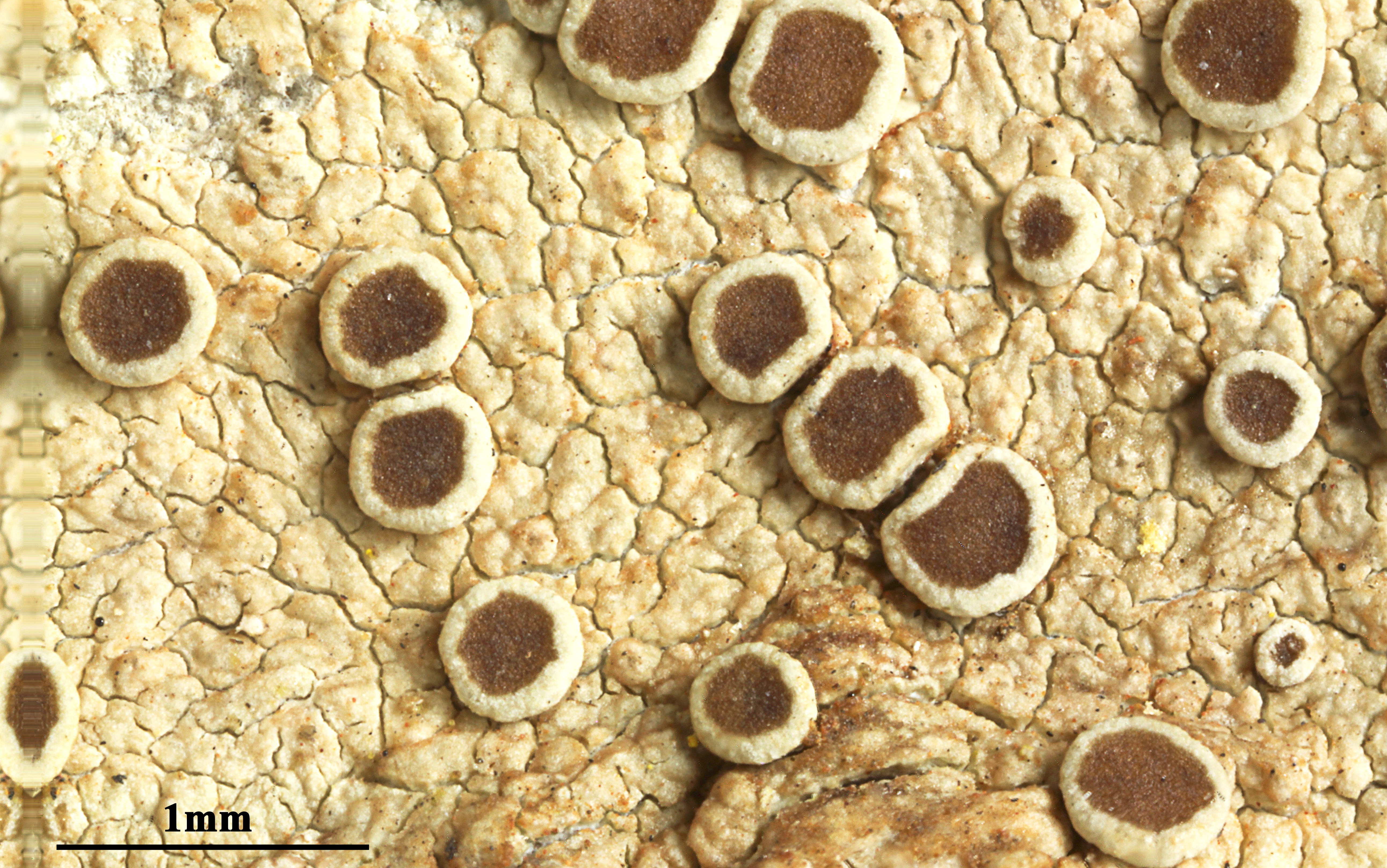
Description: Thallus crustose, continuous to rimose-verrucose, white, yellowish white or grey-white, sometimes delimited by a dark prothallus. Apothecia lecanorine, sessile, 0.4-1.5(-2) mm across, with a flat, red-brown, epruinose disc and a persistent, smooth or rarely flexuose or crenulate thalline margin. Thalline exciple corticate, with large crystals insoluble in K (well-visible under polarized light), the cortex basally thickened; proper exciple colourless, with crystals insoluble in K, epithecium red-brown to orange-brown, the pigment not dissolving in K, without crystals; hymenium colourless, not inspersed with oil droplets, (60-)75-90(-100) µm high; paraphyses simple or sparingly branched, 1.5-2 µm thick at mid-level, the apical cells slightly thickened to capitate and up to 4 µm wide; hypothecium colourless, not inspersed with oil droplets. Asci 8-spored, clavate, very thin-walled, with a K/I+ blue, tall tholus penetrated by a faintly amyloid apical cushion, the wall K/I-, surrounded by a blue outer layer, Lecanora-type. Ascospores 1-celled, hyaline, ellipsoid, 10-15(-18) x (5.5-)7-9(-10) µm, the wall 0.6-1.2 µm thick. Pycnidia immersed, cerebriform. Conidia thread-like, 17-22 µm long. Photobiont chlorococcoid. Spot tests: thallus K+ yellow, C-, KC-, P- or P+ pale yellow. Chemistry: atranorin (major), chloroatranorin (minor), 4-dichlorogangaleoidin (minor), gangaleoidin (major) and norgangaleoidin (minor).
Growth form: Crustose
Substrata: bark
Photobiont: green algae other than Trentepohlia
Reproductive strategy: mainly sexual
Commonnes-rarity: (info)
Alpine belt: absent
Subalpine belt: rare
Montane belt: extremely common
Dry submediterranean belt: very rare
Humid submediterranean belt: rare
Padanian area: extremely rare
pH of the substrata:
1 2 3 4 5

Solar irradiation:
1 2 3 4 5
Aridity:
1 2 3 4 5
Eutrophication:
1 2 3 4 5
Poleotolerance:
0 1 2 3
Altitudinal distribution:
1 2 3 4 5 6
Rarity
absent
extremely rare
very rare
rare
rather rare
rather common
common
very common
extremely common
Loading data...
Occurrence data
Predictive map
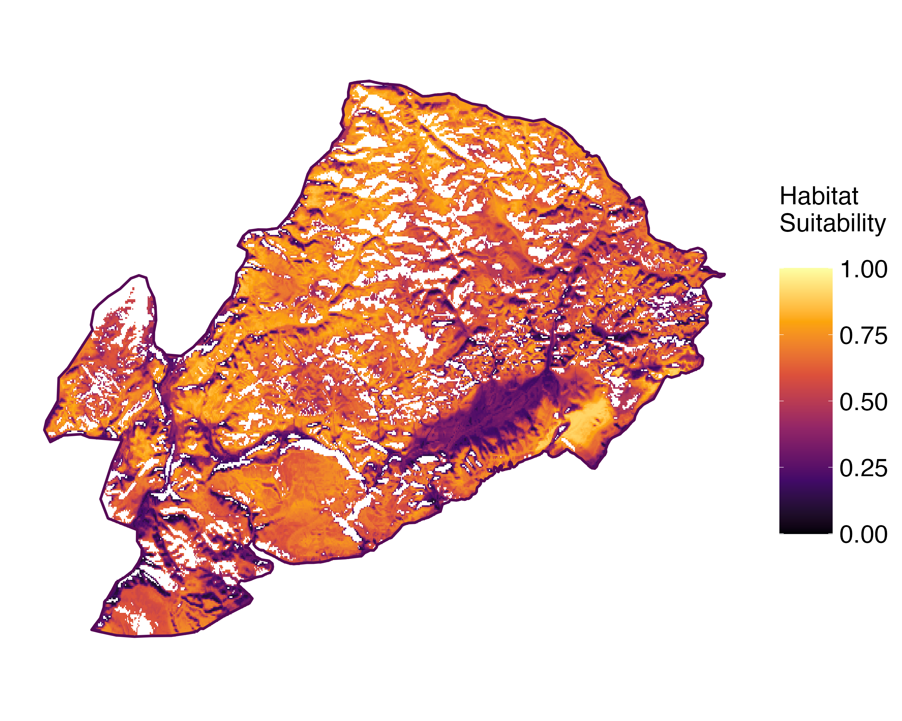 Current prediction (1981-2010)
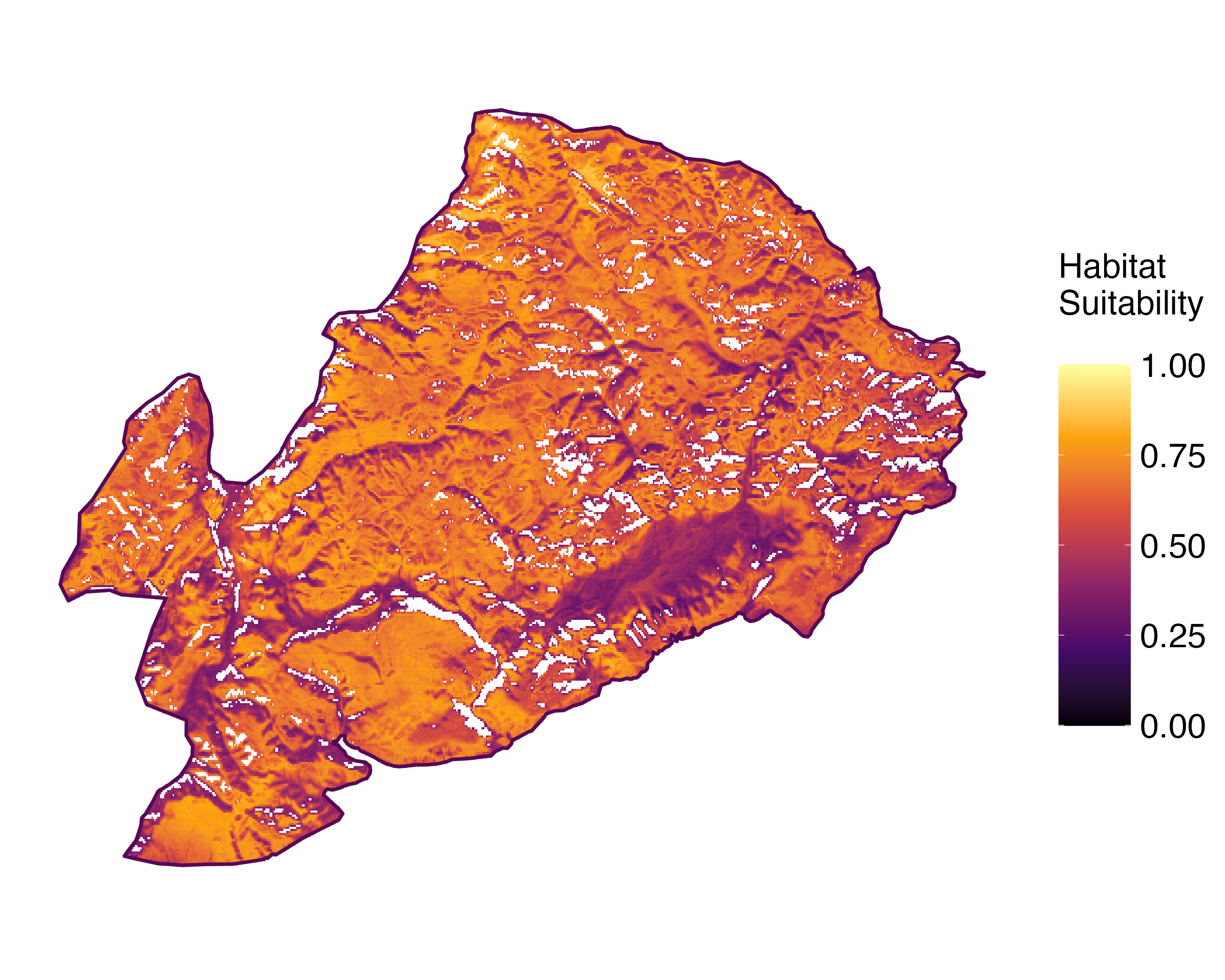 Future prediction (2071-2100) SSP 1-2.6
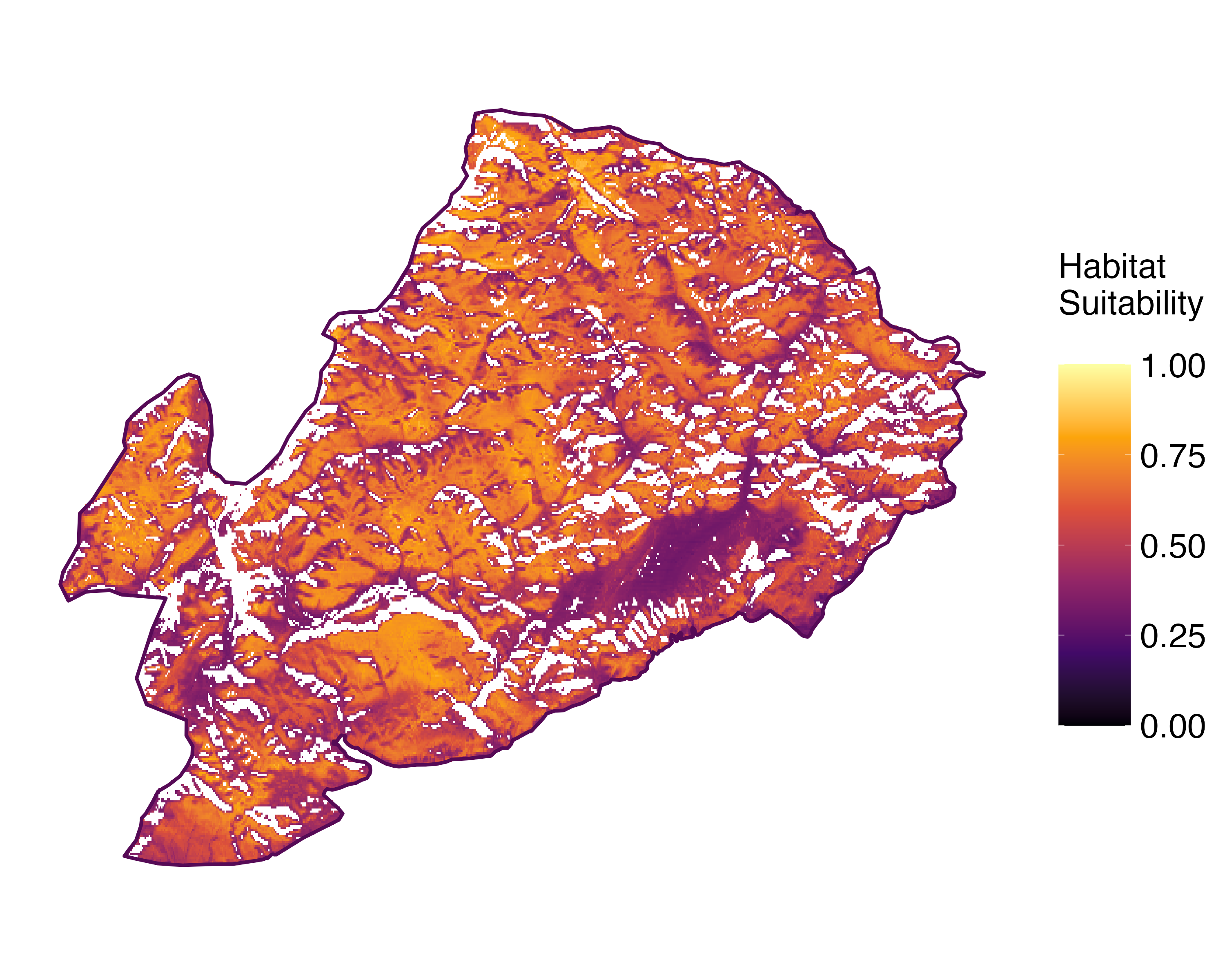 Future prediction (2071-2100) SSP 5-8.5Predictive maps according to Francesconi et al. 2025
P.L. Nimis; Owner: Department of Life Sciences, University of Trieste
Herbarium: TSB (16568)
2001/11/25

P.L. Nimis; Owner: Department of Life Sciences, University of Trieste
Herbarium: TSB (35009)
2002/05/16

Andrea Moro; Owner: Department of Life Sciences, University of Trieste
Italia, Friuli-Venezia Giulia, UD, Comune di Sauris, Bosco della Stua presso il Lago
2008.26.08

Andrea Moro; Owner: Department of Life Sciences, University of Trieste
Italia, Friuli-Venezia Giulia, UD, Comune di Sauris, Bosco della Stua presso il Lago
2008.26.08

P.L. Nimis; Owner: Department of Life Sciences, University of Trieste
Italy, Friuli Venezia Giulia, Udine, Bosco della Stua, Lago di Sauris, 1000m
09.09.2016

Andrea Moro; Owner: Department of Life Sciences, University of Trieste
Italy, Friuli Venezia Giulia, Udine, Lago di Sauris, Bosco della Stua, Carnic Alps (Ampezzo Carnico) 1000 m; altitude: 1000 m
12/08/2017

Andrea Moro; Owner: Department of Life Sciences, University of Trieste
Italy, Friuli Venezia Giulia, Udine, Lago di Sauris, Bosco della Stua, Carnic Alps (Ampezzo Carnico) 1000 m; altitude: 1000 m
12/08/2017

Andrea Moro; Owner: Department of Life Sciences, University of Trieste
Italy, Friuli Venezia Giulia, Udine, Lago di Sauris, Bosco della Stua, Carnic Alps (Ampezzo Carnico) 1000 m; altitude: 1000 m
12/08/2017

Andrea Moro; Owner: Department of Life Sciences, University of Trieste
Italy, Friuli Venezia Giulia, Udine, Lago di Sauris, Bosco della Stua, Carnic Alps (Ampezzo Carnico) 1000 m; altitude: 1000 m
12/08/2017

Felix Schumm – CC BY-SA 4.0
[1002], Germany, Baden-Württemberg, Schwäbische Alb, Kreis Heidenheim, Reishalde beim Dudelhof südlich von Steinheim, ca. 630 m, Buchen im Laubwald, TK 7326/1. Leg et det. Schumm 30.05.1971

Felix Schumm – CC BY-SA 4.0
[1002], Germany, Baden-Württemberg, Schwäbische Alb, Kreis Heidenheim, Reishalde beim Dudelhof südlich von Steinheim, ca. 630 m, Buchen im Laubwald, TK 7326/1. Leg et det. Schumm 30.05.1971

Felix Schumm – CC BY-SA 4.0
[1002], Germany, Baden-Württemberg, Schwäbische Alb, Kreis Heidenheim, Reishalde beim Dudelhof südlich von Steinheim, ca. 630 m, Buchen im Laubwald, TK 7326/1. Leg et det. Schumm 30.05.1971

Felix Schumm – CC BY-SA 4.0
[1002], Germany, Baden-Württemberg, Schwäbische Alb, Kreis Heidenheim, Reishalde beim Dudelhof südlich von Steinheim, ca. 630 m, Buchen im Laubwald, TK 7326/1. Leg et det. Schumm 30.05.1971

Felix Schumm – CC BY-SA 4.0
[1002], Germany, Baden-Württemberg, Schwäbische Alb, Kreis Heidenheim, Reishalde beim Dudelhof südlich von Steinheim, ca. 630 m, Buchen im Laubwald, TK 7326/1. Leg et det. Schumm 30.05.1971

Felix Schumm – CC BY-SA 4.0
[1002], Germany, Baden-Württemberg, Schwäbische Alb, Kreis Heidenheim, Reishalde beim Dudelhof südlich von Steinheim, ca. 630 m, Buchen im Laubwald, TK 7326/1. Leg et det. Schumm 30.05.1971

Felix Schumm – CC BY-SA 4.0
[1002], Germany, Baden-Württemberg, Schwäbische Alb, Kreis Heidenheim, Reishalde beim Dudelhof südlich von Steinheim, ca. 630 m, Buchen im Laubwald, TK 7326/1. Leg et det. Schumm 30.05.1971

Felix Schumm – CC BY-SA 4.0
[1002], Germany, Baden-Württemberg, Schwäbische Alb, Kreis Heidenheim, Reishalde beim Dudelhof südlich von Steinheim, ca. 630 m, Buchen im Laubwald, TK 7326/1. Leg et det. Schumm 30.05.1971

Felix Schumm – CC BY-SA 4.0
[1002], Germany, Baden-Württemberg, Schwäbische Alb, Kreis Heidenheim, Reishalde beim Dudelhof südlich von Steinheim, ca. 630 m, Buchen im Laubwald, TK 7326/1. Leg et det. Schumm 30.05.1971

Felix Schumm – CC BY-SA 4.0
[1002], Germany, Baden-Württemberg, Schwäbische Alb, Kreis Heidenheim, Reishalde beim Dudelhof südlich von Steinheim, ca. 630 m, Buchen im Laubwald, TK 7326/1. Leg et det. Schumm 30.05.1971

Felix Schumm – CC BY-SA 4.0
[1002], Germany, Baden-Württemberg, Schwäbische Alb, Kreis Heidenheim, Reishalde beim Dudelhof südlich von Steinheim, ca. 630 m, Buchen im Laubwald, TK 7326/1. Leg et det. Schumm 30.05.1971

Felix Schumm – CC BY-SA 4.0
[11159], Portugal, Azoren, Sao Miguel, zwischen Achadinha und Achada, 37°50.794' N, 25°16.686' W, am Straßenrand auf Quercus. Leg. et det. Schumm 05.06.2003, conf. Aptroot 2010.

Felix Schumm – CC BY-SA 4.0
[11159], Portugal, Azoren, Sao Miguel, zwischen Achadinha und Achada, 37°50.794' N, 25°16.686' W, am Straßenrand auf Quercus. Leg. et det. Schumm 05.06.2003, conf. Aptroot 2010.

Felix Schumm – CC BY-SA 4.0
[11159], Portugal, Azoren, Sao Miguel, zwischen Achadinha und Achada, 37°50.794' N, 25°16.686' W, am Straßenrand auf Quercus. Leg. et det. Schumm 05.06.2003, conf. Aptroot 2010.

Felix Schumm – CC BY-SA 4.0
[11159], Portugal, Azoren, Sao Miguel, zwischen Achadinha und Achada, 37°50.794' N, 25°16.686' W, am Straßenrand auf Quercus. Leg. et det. Schumm 05.06.2003, conf. Aptroot 2010.

Felix Schumm – CC BY-SA 4.0
[11159], Portugal, Azoren, Sao Miguel, zwischen Achadinha und Achada, 37°50.794' N, 25°16.686' W, am Straßenrand auf Quercus. Leg. et det. Schumm 05.06.2003, conf. Aptroot 2010.

Felix Schumm – CC BY-SA 4.0
[11159], Portugal, Azoren, Sao Miguel, zwischen Achadinha und Achada, 37°50.794' N, 25°16.686' W, am Straßenrand auf Quercus. Leg. et det. Schumm 05.06.2003, conf. Aptroot 2010.

Felix Schumm – CC BY-SA 4.0
[11159], Portugal, Azoren, Sao Miguel, zwischen Achadinha und Achada, 37°50.794' N, 25°16.686' W, am Straßenrand auf Quercus. Leg. et det. Schumm 05.06.2003, conf. Aptroot 2010.

Felix Schumm – CC BY-SA 4.0
[11159], Portugal, Azoren, Sao Miguel, zwischen Achadinha und Achada, 37°50.794' N, 25°16.686' W, am Straßenrand auf Quercus. Leg. et det. Schumm 05.06.2003, conf. Aptroot 2010.

Felix Schumm – CC BY-SA 4.0
[11159], Portugal, Azoren, Sao Miguel, zwischen Achadinha und Achada, 37°50.794' N, 25°16.686' W, am Straßenrand auf Quercus. Leg. et det. Schumm 05.06.2003, conf. Aptroot 2010.
at: atranorin ga: gangaleoidin

Felix Schumm – CC BY-SA 4.0
[17982], Germany, Baden-Württemberg, Kreis Göppingen, zwischen Nassach und Oberberken, Waldweg zwischen Stärrerberg und Gaibhalden, 48.75491° N, 9.54289° E, 377 m, an Esche. Leg. Schumm 03.04.2012, det. Schumm 2012.

Felix Schumm – CC BY-SA 4.0
[17982], Germany, Baden-Württemberg, Kreis Göppingen, zwischen Nassach und Oberberken, Waldweg zwischen Stärrerberg und Gaibhalden, 48.75491° N, 9.54289° E, 377 m, an Esche. Leg. Schumm 03.04.2012, det. Schumm 2012.

Felix Schumm – CC BY-SA 4.0
[17982], Germany, Baden-Württemberg, Kreis Göppingen, zwischen Nassach und Oberberken, Waldweg zwischen Stärrerberg und Gaibhalden, 48.75491° N, 9.54289° E, 377 m, an Esche. Leg. Schumm 03.04.2012, det. Schumm 2012.

Felix Schumm – CC BY-SA 4.0
[17982], Germany, Baden-Württemberg, Kreis Göppingen, zwischen Nassach und Oberberken, Waldweg zwischen Stärrerberg und Gaibhalden, 48.75491° N, 9.54289° E, 377 m, an Esche. Leg. Schumm 03.04.2012, det. Schumm 2012.

Felix Schumm – CC BY-SA 4.0
[17982], Germany, Baden-Württemberg, Kreis Göppingen, zwischen Nassach und Oberberken, Waldweg zwischen Stärrerberg und Gaibhalden, 48.75491° N, 9.54289° E, 377 m, an Esche. Leg. Schumm 03.04.2012, det. Schumm 2012.

Felix Schumm – CC BY-SA 4.0
[17982], Germany, Baden-Württemberg, Kreis Göppingen, zwischen Nassach und Oberberken, Waldweg zwischen Stärrerberg und Gaibhalden, 48.75491° N, 9.54289° E, 377 m, an Esche. Leg. Schumm 03.04.2012, det. Schumm 2012.

Felix Schumm – CC BY-SA 4.0
[17982], Germany, Baden-Württemberg, Kreis Göppingen, zwischen Nassach und Oberberken, Waldweg zwischen Stärrerberg und Gaibhalden, 48.75491° N, 9.54289° E, 377 m, an Esche. Leg. Schumm 03.04.2012, det. Schumm 2012.

Felix Schumm – CC BY-SA 4.0
[17982], Germany, Baden-Württemberg, Kreis Göppingen, zwischen Nassach und Oberberken, Waldweg zwischen Stärrerberg und Gaibhalden, 48.75491° N, 9.54289° E, 377 m, an Esche. Leg. Schumm 03.04.2012, det. Schumm 2012.

Felix Schumm – CC BY-SA 4.0
[17982], Germany, Baden-Württemberg, Kreis Göppingen, zwischen Nassach und Oberberken, Waldweg zwischen Stärrerberg und Gaibhalden, 48.75491° N, 9.54289° E, 377 m, an Esche. Leg. Schumm 03.04.2012, det. Schumm 2012.

Felix Schumm – CC BY-SA 4.0
[17982], Germany, Baden-Württemberg, Kreis Göppingen, zwischen Nassach und Oberberken, Waldweg zwischen Stärrerberg und Gaibhalden, 48.75491° N, 9.54289° E, 377 m, an Esche. Leg. Schumm 03.04.2012, det. Schumm 2012.

Felix Schumm – CC BY-SA 4.0
[17982], Germany, Baden-Württemberg, Kreis Göppingen, zwischen Nassach und Oberberken, Waldweg zwischen Stärrerberg und Gaibhalden, 48.75491° N, 9.54289° E, 377 m, an Esche. Leg. Schumm 03.04.2012, det. Schumm 2012.

Felix Schumm – CC BY-SA 4.0
[17982], Germany, Baden-Württemberg, Kreis Göppingen, zwischen Nassach und Oberberken, Waldweg zwischen Stärrerberg und Gaibhalden, 48.75491° N, 9.54289° E, 377 m, an Esche. Leg. Schumm 03.04.2012, det. Schumm 2012.

Felix Schumm – CC BY-SA 4.0
[17982], Germany, Baden-Württemberg, Kreis Göppingen, zwischen Nassach und Oberberken, Waldweg zwischen Stärrerberg und Gaibhalden, 48.75491° N, 9.54289° E, 377 m, an Esche. Leg. Schumm 03.04.2012, det. Schumm 2012.

Pier Luigi Nimis CC BY-SA 4.0
TSB 39777

Zahlbruckner A. 1926. Lichenes (Flechten). In: Engler A. (ed.): Die natürlichen Pflanzenfamilien. 2nd ed., vol 8, W. Engelmann, Leipzig, 270 pp.

Zahlbruckner A. 1926. Lichenes (Flechten). In: Engler A. (ed.): Die natürlichen Pflanzenfamilien. 2nd ed., vol 8, W. Engelmann, Leipzig, 270 pp.

P.L. Nimis CC BY-SA 04
TSB 34834

Walter Obermayer CC BY-SA 4.0 - Source: Lichens of Noricum - http://lichens-of-noricum.uni-graz.at/
Austria
together with L. pulicaris reacting P+ red

Walter Obermayer CC BY-SA 4.0 - Source: Lichens of Noricum - http://lichens-of-noricum.uni-graz.at/
Austria
together with L. pulicaris reacting P+ red

Courtesy Danièle et Olivier Gonnet - Source: https://www.afl-lichenologie.fr/Photos_AFL/Photos_AFL_L/Texte_L_2/Lecanora_argentata.htm
France, Barbotan-les-thermes
6/6/2015

Courtesy Danièle et Olivier Gonnet - Source: https://www.afl-lichenologie.fr/Photos_AFL/Photos_AFL_L/Texte_L_2/Lecanora_argentata.htm
France, Barbotan-les-thermes
6/6/2015

Courtesy Danièle et Olivier Gonnet - Source: https://www.afl-lichenologie.fr/Photos_AFL/Photos_AFL_L/Texte_L_2/Lecanora_argentata.htm
France, Barbotan-les-thermes
6/6/2015

Courtesy Danièle et Olivier Gonnet - Source: https://www.afl-lichenologie.fr/Photos_AFL/Photos_AFL_L/Texte_L_2/Lecanora_argentata.htm
France, Barbotan-les-thermes
6/6/2015

Bernard Bouffinier - Source: http://www.lichensmaritimes.org/index.php?task=fiche&lichen=456&lang=en
France, Lesteven

Bernard Bouffinier - Source: http://www.lichensmaritimes.org/index.php?task=fiche&lichen=456&lang=en
France, Camaret

Bernard Bouffinier - Source: http://www.lichensmaritimes.org/index.php?task=fiche&lichen=456&lang=en
France, Huelgoat

Bernard Bouffinier - Source: http://www.lichensmaritimes.org/index.php?task=fiche&lichen=456&lang=en
France, Huelgoat

Jacques Haine - Source: http://www.lichensmaritimes.org/index.php?task=fiche&lichen=456&lang=en
France

Jacques Haine - Source: http://www.lichensmaritimes.org/index.php?task=fiche&lichen=456&lang=en
France, Remuzat

Jacques Haine - Source: http://www.lichensmaritimes.org/index.php?task=fiche&lichen=456&lang=en
France, Argol

Jacques Haine - Source: http://www.lichensmaritimes.org/index.php?task=fiche&lichen=456&lang=en
France, Remuzat

Jacques Haine - Source: http://www.lichensmaritimes.org/index.php?task=fiche&lichen=456&lang=en
France, Mercantour

Jacques Haine - Source: http://www.lichensmaritimes.org/index.php?task=fiche&lichen=456&lang=en
France, Argol

Jacques Haine - Source: http://www.lichensmaritimes.org/index.php?task=fiche&lichen=456&lang=en
France, Argol

Jacques Haine - Source: http://www.lichensmaritimes.org/index.php?task=fiche&lichen=456&lang=en
France, Argol

Ulrich Kirschbaum CC BY-SA 4.0 - Source: https://www.thm.de/lse/ulrich-kirschbaum/flechtenbilder
Central Europe; Germany: Hunsrück Mountains.
as L. subrugosa
Felix Schumm - CC BY-SA 4.0
[ABL77059], Brazil, Mato Grosso do Sul, Bonito, Fazenda Marambaia,
in Atlantic rain forest on tree bark. 20°58’ S, 56°42’ W, 650 m. Leg. A.
Aptroot (no 77059), 30.10.2018, det. A. Aptroot, 2019.
Felix Schumm - CC BY-SA 4.0
[ABL77059], Brazil, Mato Grosso do Sul, Bonito, Fazenda Marambaia,
in Atlantic rain forest on tree bark. 20°58’ S, 56°42’ W, 650 m. Leg. A.
Aptroot (no 77059), 30.10.2018, det. A. Aptroot, 2019.
Felix Schumm - CC BY 4.0
[VZ139], Suecia. Öland, Böda Paroecia, Skäftekärr. Ad corticem Fraxini
excelsioris. Leg. R. Santesson (no.16374), 4.7.1964, det- O. Vitikainen
(1872). EX A. VEZDA LICHENES SELECTI EXSICCATI NR. 1139. As Lecanora subfuscata
Growth form: Crustose
Substrata: bark
Photobiont: green algae other than Trentepohlia
Reproductive strategy: mainly sexual
Commonnes-rarity: (info)
Alpine belt: absent
Subalpine belt: rare
Montane belt: extremely common
Dry submediterranean belt: very rare
Humid submediterranean belt: rare
Padanian area: extremely rare
pH of the substrata:
| 1 | 2 | 3 | 4 | 5 |
Solar irradiation:
| 1 | 2 | 3 | 4 | 5 |
Aridity:
| 1 | 2 | 3 | 4 | 5 |
Eutrophication:
| 1 | 2 | 3 | 4 | 5 |
Poleotolerance:
| 0 | 1 | 2 | 3 |
Altitudinal distribution:
| 1 | 2 | 3 | 4 | 5 | 6 |
Rarity
absent
extremely rare
very rare
rare
rather rare
rather common
common
very common
extremely common
Loading data...
Occurrence data
Predictive map
Current prediction (1981-2010)Future prediction (2071-2100) SSP 1-2.6Future prediction (2071-2100) SSP 5-8.5Predictive maps according to Francesconi et al. 2025
P.L. Nimis; Owner: Department of Life Sciences, University of Trieste
Herbarium: TSB (16568)
2001/11/25
P.L. Nimis; Owner: Department of Life Sciences, University of Trieste
Herbarium: TSB (35009)
2002/05/16
Andrea Moro; Owner: Department of Life Sciences, University of Trieste
Italia, Friuli-Venezia Giulia, UD, Comune di Sauris, Bosco della Stua presso il Lago
2008.26.08
Andrea Moro; Owner: Department of Life Sciences, University of Trieste
Italia, Friuli-Venezia Giulia, UD, Comune di Sauris, Bosco della Stua presso il Lago
2008.26.08
P.L. Nimis; Owner: Department of Life Sciences, University of Trieste
Italy, Friuli Venezia Giulia, Udine, Bosco della Stua, Lago di Sauris, 1000m
09.09.2016

Andrea Moro; Owner: Department of Life Sciences, University of Trieste
Italy, Friuli Venezia Giulia, Udine, Lago di Sauris, Bosco della Stua, Carnic Alps (Ampezzo Carnico) 1000 m; altitude: 1000 m
12/08/2017
Andrea Moro; Owner: Department of Life Sciences, University of Trieste
Italy, Friuli Venezia Giulia, Udine, Lago di Sauris, Bosco della Stua, Carnic Alps (Ampezzo Carnico) 1000 m; altitude: 1000 m
12/08/2017
Andrea Moro; Owner: Department of Life Sciences, University of Trieste
Italy, Friuli Venezia Giulia, Udine, Lago di Sauris, Bosco della Stua, Carnic Alps (Ampezzo Carnico) 1000 m; altitude: 1000 m
12/08/2017

Andrea Moro; Owner: Department of Life Sciences, University of Trieste
Italy, Friuli Venezia Giulia, Udine, Lago di Sauris, Bosco della Stua, Carnic Alps (Ampezzo Carnico) 1000 m; altitude: 1000 m
12/08/2017
Felix Schumm – CC BY-SA 4.0
[1002], Germany, Baden-Württemberg, Schwäbische Alb, Kreis Heidenheim, Reishalde beim Dudelhof südlich von Steinheim, ca. 630 m, Buchen im Laubwald, TK 7326/1. Leg et det. Schumm 30.05.1971

Felix Schumm – CC BY-SA 4.0
[1002], Germany, Baden-Württemberg, Schwäbische Alb, Kreis Heidenheim, Reishalde beim Dudelhof südlich von Steinheim, ca. 630 m, Buchen im Laubwald, TK 7326/1. Leg et det. Schumm 30.05.1971
Felix Schumm – CC BY-SA 4.0
[1002], Germany, Baden-Württemberg, Schwäbische Alb, Kreis Heidenheim, Reishalde beim Dudelhof südlich von Steinheim, ca. 630 m, Buchen im Laubwald, TK 7326/1. Leg et det. Schumm 30.05.1971
Felix Schumm – CC BY-SA 4.0
[1002], Germany, Baden-Württemberg, Schwäbische Alb, Kreis Heidenheim, Reishalde beim Dudelhof südlich von Steinheim, ca. 630 m, Buchen im Laubwald, TK 7326/1. Leg et det. Schumm 30.05.1971
Felix Schumm – CC BY-SA 4.0
[1002], Germany, Baden-Württemberg, Schwäbische Alb, Kreis Heidenheim, Reishalde beim Dudelhof südlich von Steinheim, ca. 630 m, Buchen im Laubwald, TK 7326/1. Leg et det. Schumm 30.05.1971

Felix Schumm – CC BY-SA 4.0
[1002], Germany, Baden-Württemberg, Schwäbische Alb, Kreis Heidenheim, Reishalde beim Dudelhof südlich von Steinheim, ca. 630 m, Buchen im Laubwald, TK 7326/1. Leg et det. Schumm 30.05.1971
Felix Schumm – CC BY-SA 4.0
[1002], Germany, Baden-Württemberg, Schwäbische Alb, Kreis Heidenheim, Reishalde beim Dudelhof südlich von Steinheim, ca. 630 m, Buchen im Laubwald, TK 7326/1. Leg et det. Schumm 30.05.1971
Felix Schumm – CC BY-SA 4.0
[1002], Germany, Baden-Württemberg, Schwäbische Alb, Kreis Heidenheim, Reishalde beim Dudelhof südlich von Steinheim, ca. 630 m, Buchen im Laubwald, TK 7326/1. Leg et det. Schumm 30.05.1971
Felix Schumm – CC BY-SA 4.0
[1002], Germany, Baden-Württemberg, Schwäbische Alb, Kreis Heidenheim, Reishalde beim Dudelhof südlich von Steinheim, ca. 630 m, Buchen im Laubwald, TK 7326/1. Leg et det. Schumm 30.05.1971
Felix Schumm – CC BY-SA 4.0
[1002], Germany, Baden-Württemberg, Schwäbische Alb, Kreis Heidenheim, Reishalde beim Dudelhof südlich von Steinheim, ca. 630 m, Buchen im Laubwald, TK 7326/1. Leg et det. Schumm 30.05.1971
Felix Schumm – CC BY-SA 4.0
[1002], Germany, Baden-Württemberg, Schwäbische Alb, Kreis Heidenheim, Reishalde beim Dudelhof südlich von Steinheim, ca. 630 m, Buchen im Laubwald, TK 7326/1. Leg et det. Schumm 30.05.1971
Felix Schumm – CC BY-SA 4.0
[11159], Portugal, Azoren, Sao Miguel, zwischen Achadinha und Achada, 37°50.794' N, 25°16.686' W, am Straßenrand auf Quercus. Leg. et det. Schumm 05.06.2003, conf. Aptroot 2010.
Felix Schumm – CC BY-SA 4.0
[11159], Portugal, Azoren, Sao Miguel, zwischen Achadinha und Achada, 37°50.794' N, 25°16.686' W, am Straßenrand auf Quercus. Leg. et det. Schumm 05.06.2003, conf. Aptroot 2010.
Felix Schumm – CC BY-SA 4.0
[11159], Portugal, Azoren, Sao Miguel, zwischen Achadinha und Achada, 37°50.794' N, 25°16.686' W, am Straßenrand auf Quercus. Leg. et det. Schumm 05.06.2003, conf. Aptroot 2010.

Felix Schumm – CC BY-SA 4.0
[11159], Portugal, Azoren, Sao Miguel, zwischen Achadinha und Achada, 37°50.794' N, 25°16.686' W, am Straßenrand auf Quercus. Leg. et det. Schumm 05.06.2003, conf. Aptroot 2010.
Felix Schumm – CC BY-SA 4.0
[11159], Portugal, Azoren, Sao Miguel, zwischen Achadinha und Achada, 37°50.794' N, 25°16.686' W, am Straßenrand auf Quercus. Leg. et det. Schumm 05.06.2003, conf. Aptroot 2010.
Felix Schumm – CC BY-SA 4.0
[11159], Portugal, Azoren, Sao Miguel, zwischen Achadinha und Achada, 37°50.794' N, 25°16.686' W, am Straßenrand auf Quercus. Leg. et det. Schumm 05.06.2003, conf. Aptroot 2010.
Felix Schumm – CC BY-SA 4.0
[11159], Portugal, Azoren, Sao Miguel, zwischen Achadinha und Achada, 37°50.794' N, 25°16.686' W, am Straßenrand auf Quercus. Leg. et det. Schumm 05.06.2003, conf. Aptroot 2010.
Felix Schumm – CC BY-SA 4.0
[11159], Portugal, Azoren, Sao Miguel, zwischen Achadinha und Achada, 37°50.794' N, 25°16.686' W, am Straßenrand auf Quercus. Leg. et det. Schumm 05.06.2003, conf. Aptroot 2010.
Felix Schumm – CC BY-SA 4.0
[11159], Portugal, Azoren, Sao Miguel, zwischen Achadinha und Achada, 37°50.794' N, 25°16.686' W, am Straßenrand auf Quercus. Leg. et det. Schumm 05.06.2003, conf. Aptroot 2010.
at: atranorin ga: gangaleoidin

Felix Schumm – CC BY-SA 4.0
[17982], Germany, Baden-Württemberg, Kreis Göppingen, zwischen Nassach und Oberberken, Waldweg zwischen Stärrerberg und Gaibhalden, 48.75491° N, 9.54289° E, 377 m, an Esche. Leg. Schumm 03.04.2012, det. Schumm 2012.
Felix Schumm – CC BY-SA 4.0
[17982], Germany, Baden-Württemberg, Kreis Göppingen, zwischen Nassach und Oberberken, Waldweg zwischen Stärrerberg und Gaibhalden, 48.75491° N, 9.54289° E, 377 m, an Esche. Leg. Schumm 03.04.2012, det. Schumm 2012.
Felix Schumm – CC BY-SA 4.0
[17982], Germany, Baden-Württemberg, Kreis Göppingen, zwischen Nassach und Oberberken, Waldweg zwischen Stärrerberg und Gaibhalden, 48.75491° N, 9.54289° E, 377 m, an Esche. Leg. Schumm 03.04.2012, det. Schumm 2012.
Felix Schumm – CC BY-SA 4.0
[17982], Germany, Baden-Württemberg, Kreis Göppingen, zwischen Nassach und Oberberken, Waldweg zwischen Stärrerberg und Gaibhalden, 48.75491° N, 9.54289° E, 377 m, an Esche. Leg. Schumm 03.04.2012, det. Schumm 2012.

Felix Schumm – CC BY-SA 4.0
[17982], Germany, Baden-Württemberg, Kreis Göppingen, zwischen Nassach und Oberberken, Waldweg zwischen Stärrerberg und Gaibhalden, 48.75491° N, 9.54289° E, 377 m, an Esche. Leg. Schumm 03.04.2012, det. Schumm 2012.
Felix Schumm – CC BY-SA 4.0
[17982], Germany, Baden-Württemberg, Kreis Göppingen, zwischen Nassach und Oberberken, Waldweg zwischen Stärrerberg und Gaibhalden, 48.75491° N, 9.54289° E, 377 m, an Esche. Leg. Schumm 03.04.2012, det. Schumm 2012.
Felix Schumm – CC BY-SA 4.0
[17982], Germany, Baden-Württemberg, Kreis Göppingen, zwischen Nassach und Oberberken, Waldweg zwischen Stärrerberg und Gaibhalden, 48.75491° N, 9.54289° E, 377 m, an Esche. Leg. Schumm 03.04.2012, det. Schumm 2012.
Felix Schumm – CC BY-SA 4.0
[17982], Germany, Baden-Württemberg, Kreis Göppingen, zwischen Nassach und Oberberken, Waldweg zwischen Stärrerberg und Gaibhalden, 48.75491° N, 9.54289° E, 377 m, an Esche. Leg. Schumm 03.04.2012, det. Schumm 2012.
Felix Schumm – CC BY-SA 4.0
[17982], Germany, Baden-Württemberg, Kreis Göppingen, zwischen Nassach und Oberberken, Waldweg zwischen Stärrerberg und Gaibhalden, 48.75491° N, 9.54289° E, 377 m, an Esche. Leg. Schumm 03.04.2012, det. Schumm 2012.
Felix Schumm – CC BY-SA 4.0
[17982], Germany, Baden-Württemberg, Kreis Göppingen, zwischen Nassach und Oberberken, Waldweg zwischen Stärrerberg und Gaibhalden, 48.75491° N, 9.54289° E, 377 m, an Esche. Leg. Schumm 03.04.2012, det. Schumm 2012.

Felix Schumm – CC BY-SA 4.0
[17982], Germany, Baden-Württemberg, Kreis Göppingen, zwischen Nassach und Oberberken, Waldweg zwischen Stärrerberg und Gaibhalden, 48.75491° N, 9.54289° E, 377 m, an Esche. Leg. Schumm 03.04.2012, det. Schumm 2012.
Felix Schumm – CC BY-SA 4.0
[17982], Germany, Baden-Württemberg, Kreis Göppingen, zwischen Nassach und Oberberken, Waldweg zwischen Stärrerberg und Gaibhalden, 48.75491° N, 9.54289° E, 377 m, an Esche. Leg. Schumm 03.04.2012, det. Schumm 2012.
Felix Schumm – CC BY-SA 4.0
[17982], Germany, Baden-Württemberg, Kreis Göppingen, zwischen Nassach und Oberberken, Waldweg zwischen Stärrerberg und Gaibhalden, 48.75491° N, 9.54289° E, 377 m, an Esche. Leg. Schumm 03.04.2012, det. Schumm 2012.
Pier Luigi Nimis CC BY-SA 4.0
TSB 39777

Zahlbruckner A. 1926. Lichenes (Flechten). In: Engler A. (ed.): Die natürlichen Pflanzenfamilien. 2nd ed., vol 8, W. Engelmann, Leipzig, 270 pp.

Zahlbruckner A. 1926. Lichenes (Flechten). In: Engler A. (ed.): Die natürlichen Pflanzenfamilien. 2nd ed., vol 8, W. Engelmann, Leipzig, 270 pp.
P.L. Nimis CC BY-SA 04
TSB 34834

Walter Obermayer CC BY-SA 4.0 - Source: Lichens of Noricum - http://lichens-of-noricum.uni-graz.at/
Austria
together with L. pulicaris reacting P+ red

Walter Obermayer CC BY-SA 4.0 - Source: Lichens of Noricum - http://lichens-of-noricum.uni-graz.at/
Austria
together with L. pulicaris reacting P+ red
Courtesy Danièle et Olivier Gonnet - Source: https://www.afl-lichenologie.fr/Photos_AFL/Photos_AFL_L/Texte_L_2/Lecanora_argentata.htm
France, Barbotan-les-thermes
6/6/2015
Courtesy Danièle et Olivier Gonnet - Source: https://www.afl-lichenologie.fr/Photos_AFL/Photos_AFL_L/Texte_L_2/Lecanora_argentata.htm
France, Barbotan-les-thermes
6/6/2015
Courtesy Danièle et Olivier Gonnet - Source: https://www.afl-lichenologie.fr/Photos_AFL/Photos_AFL_L/Texte_L_2/Lecanora_argentata.htm
France, Barbotan-les-thermes
6/6/2015
Courtesy Danièle et Olivier Gonnet - Source: https://www.afl-lichenologie.fr/Photos_AFL/Photos_AFL_L/Texte_L_2/Lecanora_argentata.htm
France, Barbotan-les-thermes
6/6/2015

Bernard Bouffinier - Source: http://www.lichensmaritimes.org/index.php?task=fiche&lichen=456&lang=en
France, Lesteven

Bernard Bouffinier - Source: http://www.lichensmaritimes.org/index.php?task=fiche&lichen=456&lang=en
France, Camaret

Bernard Bouffinier - Source: http://www.lichensmaritimes.org/index.php?task=fiche&lichen=456&lang=en
France, Huelgoat

Bernard Bouffinier - Source: http://www.lichensmaritimes.org/index.php?task=fiche&lichen=456&lang=en
France, Huelgoat

Jacques Haine - Source: http://www.lichensmaritimes.org/index.php?task=fiche&lichen=456&lang=en
France

Jacques Haine - Source: http://www.lichensmaritimes.org/index.php?task=fiche&lichen=456&lang=en
France, Remuzat

Jacques Haine - Source: http://www.lichensmaritimes.org/index.php?task=fiche&lichen=456&lang=en
France, Argol

Jacques Haine - Source: http://www.lichensmaritimes.org/index.php?task=fiche&lichen=456&lang=en
France, Remuzat

Jacques Haine - Source: http://www.lichensmaritimes.org/index.php?task=fiche&lichen=456&lang=en
France, Mercantour

Jacques Haine - Source: http://www.lichensmaritimes.org/index.php?task=fiche&lichen=456&lang=en
France, Argol

Jacques Haine - Source: http://www.lichensmaritimes.org/index.php?task=fiche&lichen=456&lang=en
France, Argol

Jacques Haine - Source: http://www.lichensmaritimes.org/index.php?task=fiche&lichen=456&lang=en
France, Argol

Ulrich Kirschbaum CC BY-SA 4.0 - Source: https://www.thm.de/lse/ulrich-kirschbaum/flechtenbilder
Central Europe; Germany: Hunsrück Mountains.
as L. subrugosa
Felix Schumm - CC BY-SA 4.0
[ABL77059], Brazil, Mato Grosso do Sul, Bonito, Fazenda Marambaia, in Atlantic rain forest on tree bark. 20°58’ S, 56°42’ W, 650 m. Leg. A. Aptroot (no 77059), 30.10.2018, det. A. Aptroot, 2019.

Felix Schumm - CC BY-SA 4.0
[ABL77059], Brazil, Mato Grosso do Sul, Bonito, Fazenda Marambaia, in Atlantic rain forest on tree bark. 20°58’ S, 56°42’ W, 650 m. Leg. A. Aptroot (no 77059), 30.10.2018, det. A. Aptroot, 2019.