
Physciella chloantha (Ach.) Essl.
Mycologia, 78: 94, 1986. Basionym: Parmelia chloantha Ach. - Syn. Meth. Lich.: 217, 1814.
Synonyms: Phaeophyscia chloantha (Ach.) Moberg; Physcia labrata var. intermedia Mereschk.; Physcia luganensis Mereschk.; Physcia obscura var. chloantha (Ach.) Rabenh.; Physcia pragensis Nádv.
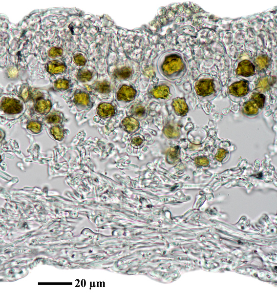
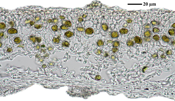
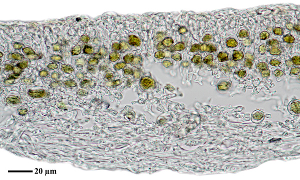
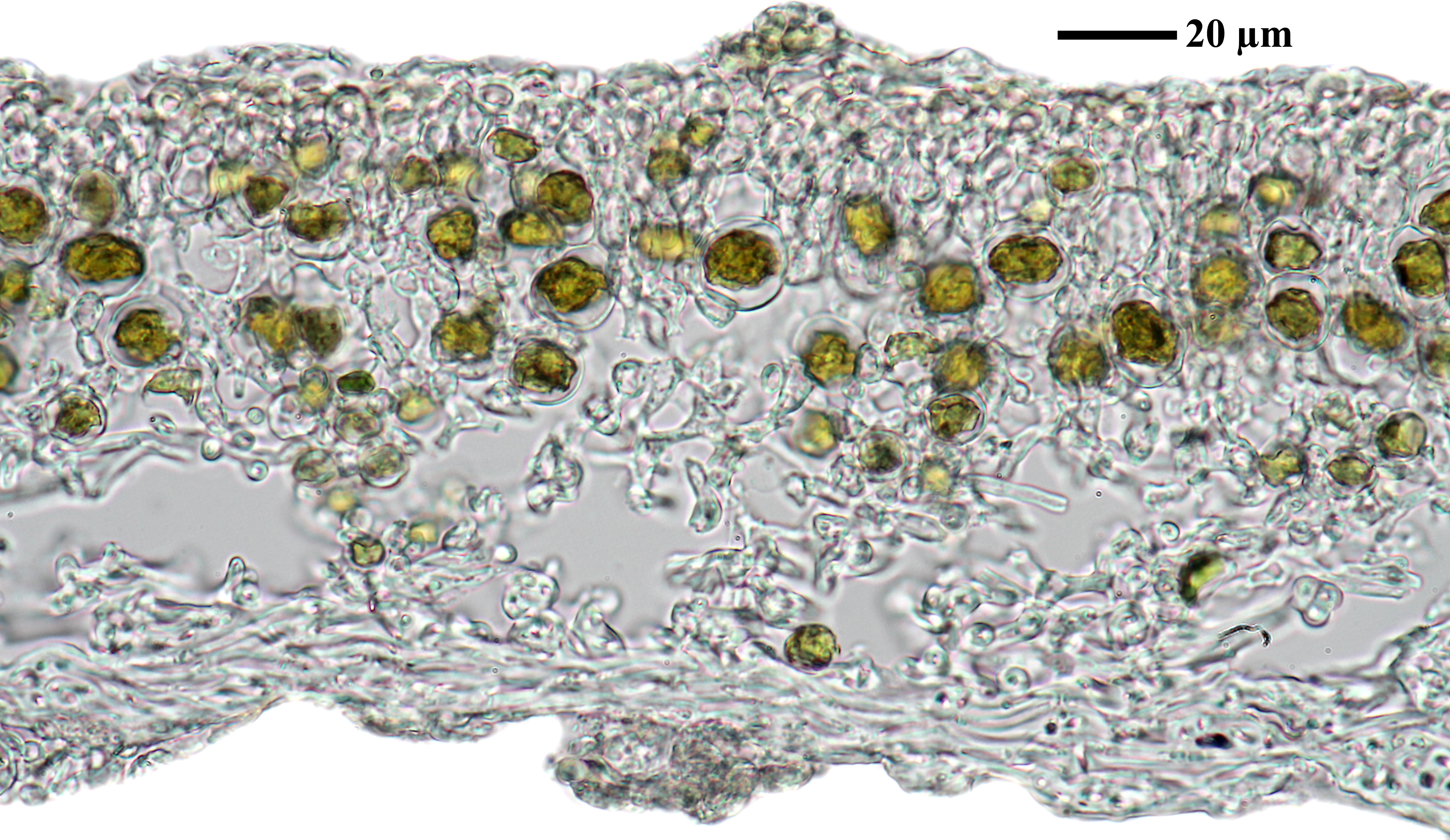
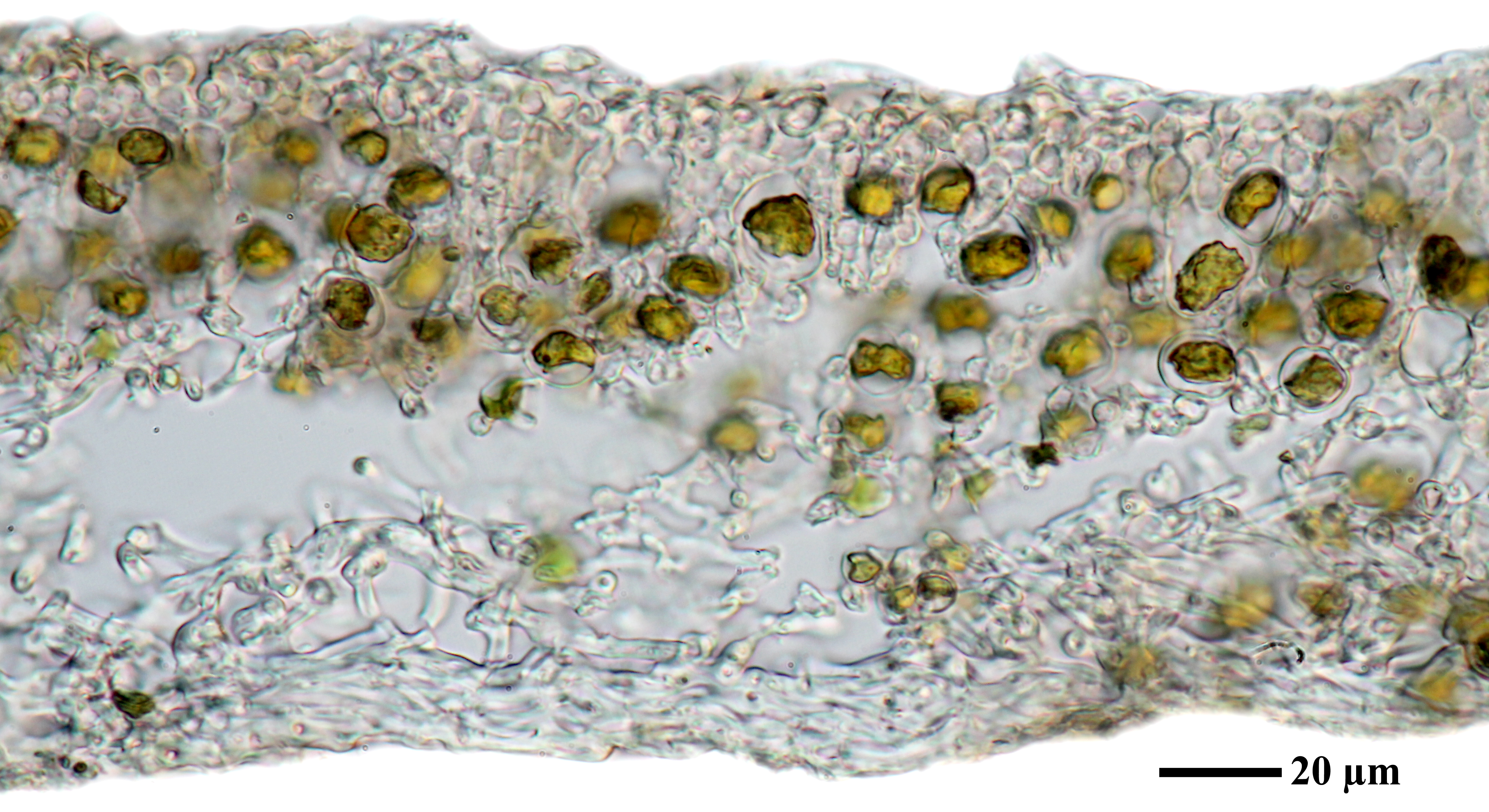
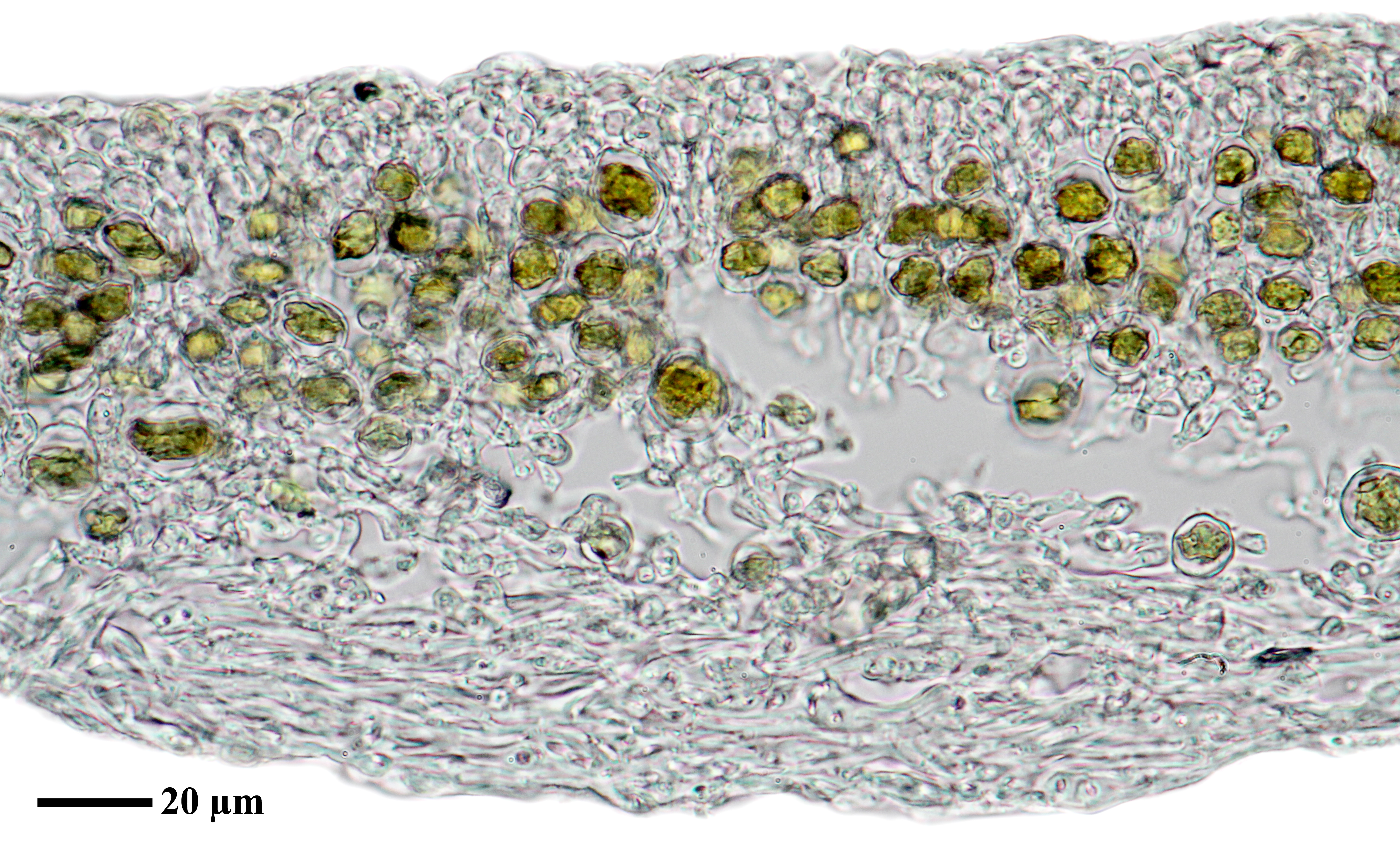
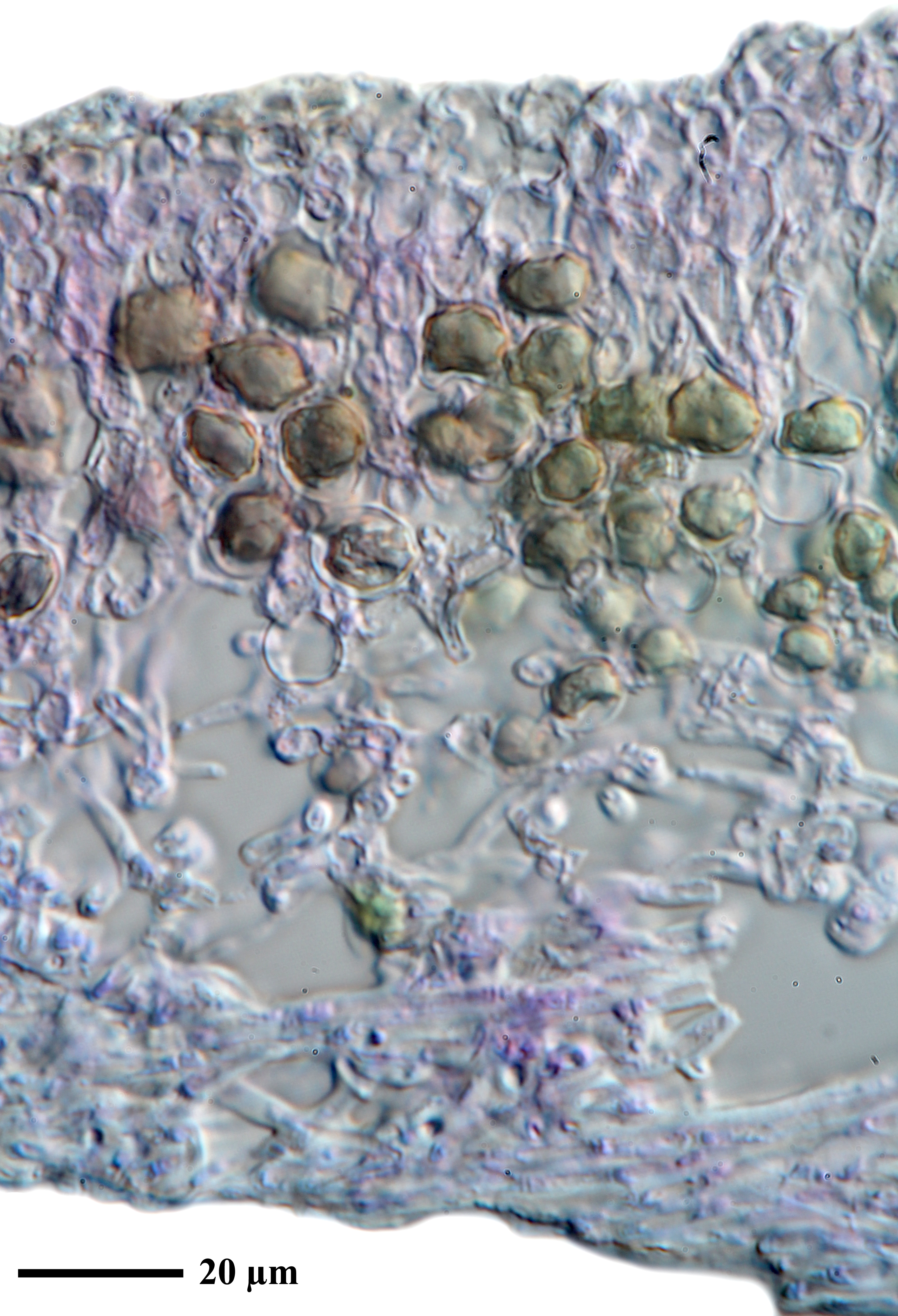
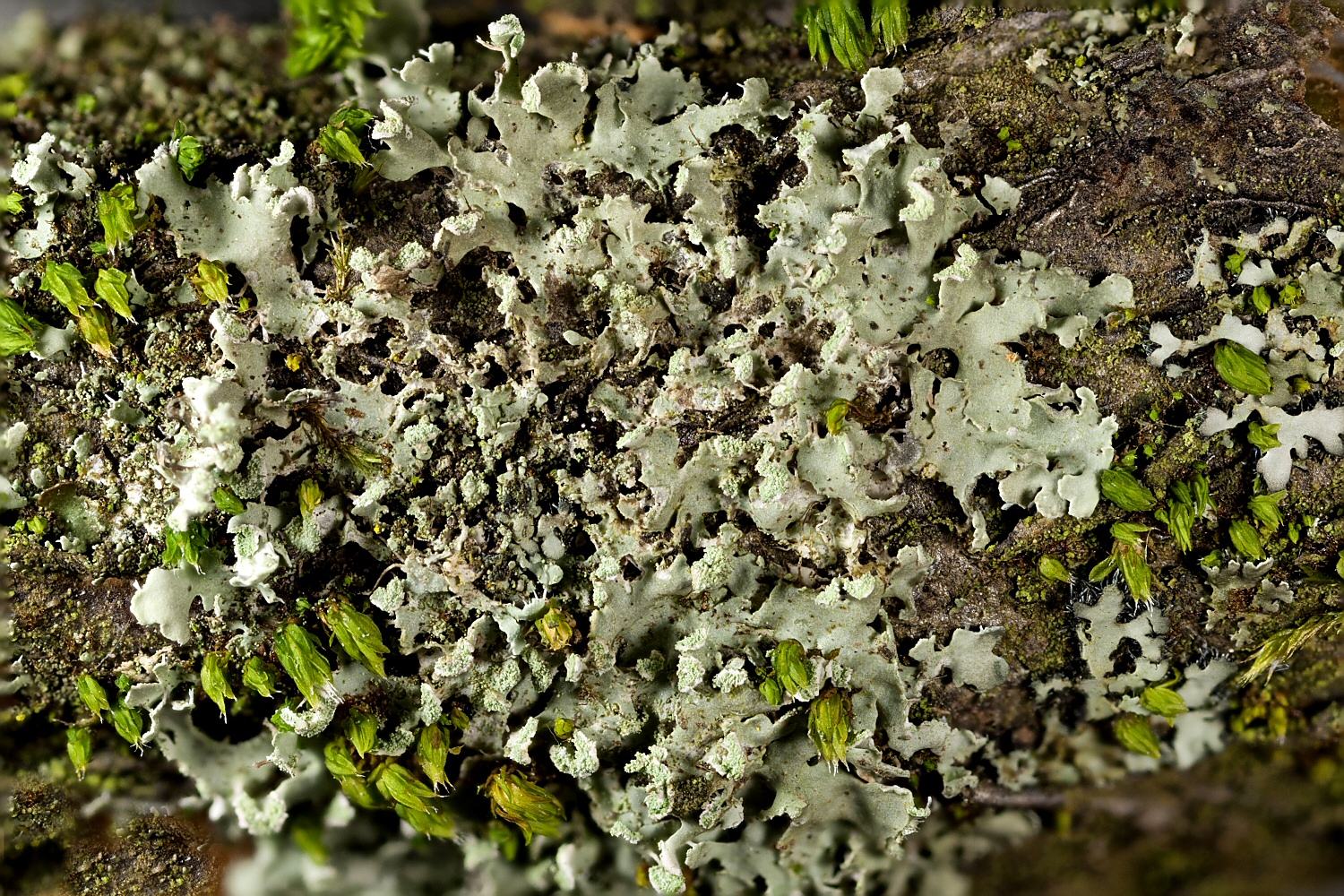
Description: Thallus foliose, heteromerous, dorsiventral, narrow-lobed, rather loosely attached, forming at first orbicular, then irregular, up to 3 cm wide rosettes. Lobes discrete to imbricate, (0.2-)0.5-1(-1.5) mm broad, flat, whitish to pale brown, epruinose, with terminal labriform soralia at the tips of ascending lobules. Lower surface white to pale tan, with simple, pale rhizines. Upper cortex paraplectenchymatous; medulla white; lower cortex prosoplectenchymatous. Apothecia very rare, lecanorine. Asci 8-spored, clavate, the K/I+ blue tholus penetrated by a faintly amyloid apical cushion with parallel or diverging flanks, the wall K/I-, surrounded by a K/I+ blue outer layer, Lecanora-type. Ascospores 1-septate, brown, ellipsoid, 17-23 x 8-11 µm, the wall thickened at apex and at septum, Physcia-type. Pycnidia rare. Conidia short-ellipsoid. Photobiont chlorococcoid. Spot tests: cortex and medulla K-, C-, KC-, P-, UV-. Chemistry: without lichen substances.
Growth form: Foliose, narrow lobed
Substrata: bark and rocks
Photobiont: green algae other than Trentepohlia
Reproductive strategy: mainly asexual, by soredia, or soredia-like structures (e.g. blastidia)
Commonnes-rarity: (info)
Alpine belt: absent
Subalpine belt: absent
Montane belt: extremely rare
Dry submediterranean belt: rather rare
Humid submediterranean belt: rather rare
Padanian area: extremely rare
pH of the substrata:
1 2 3 4 5

Solar irradiation:
1 2 3 4 5
Aridity:
1 2 3 4 5
Eutrophication:
1 2 3 4 5
Poleotolerance:
0 1 2 3
Altitudinal distribution:
1 2 3 4 5 6
Rarity
absent
extremely rare
very rare
rare
rather rare
rather common
common
very common
extremely common
Loading data...
Occurrence data
Predictive map
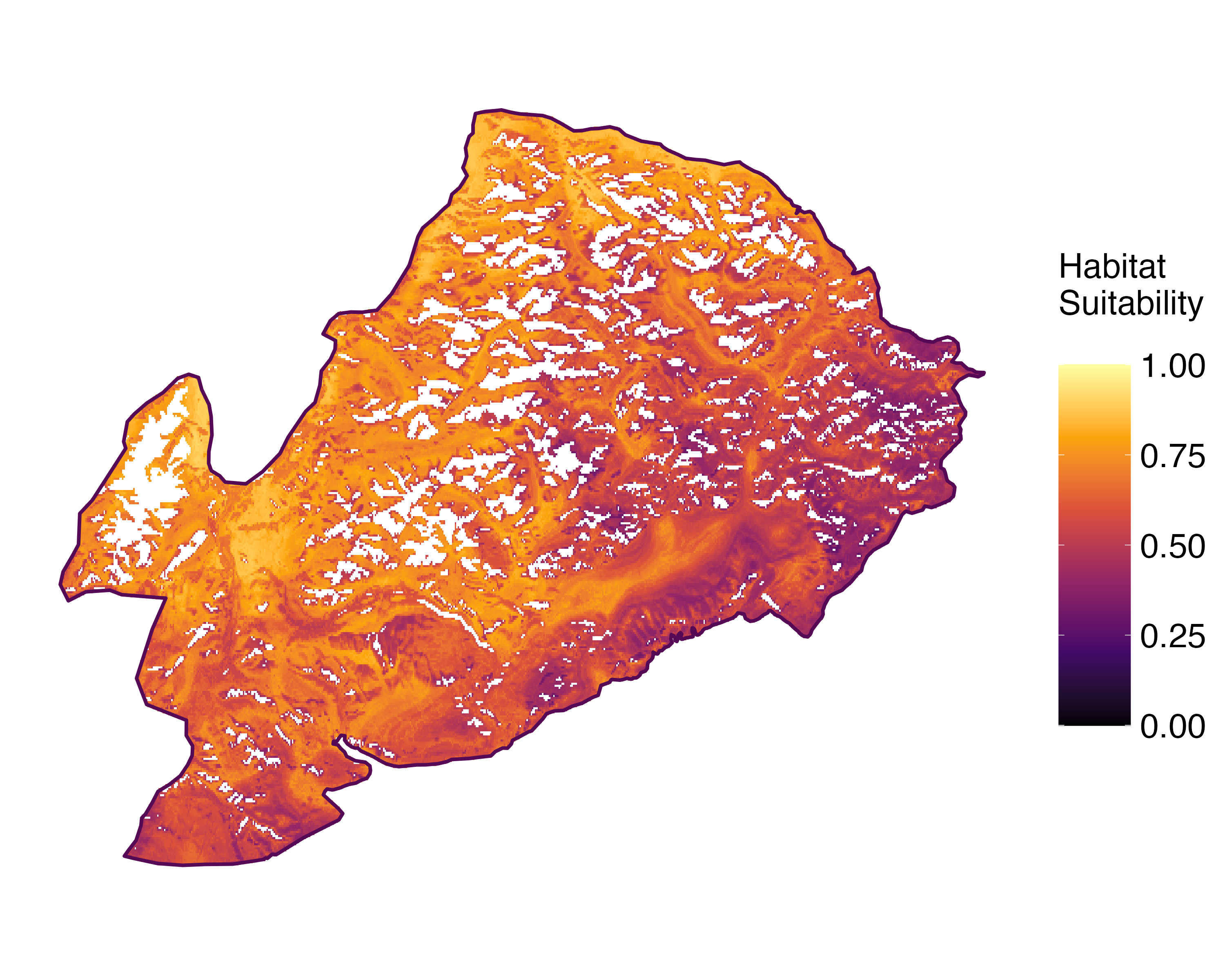 Current prediction (1981-2010)
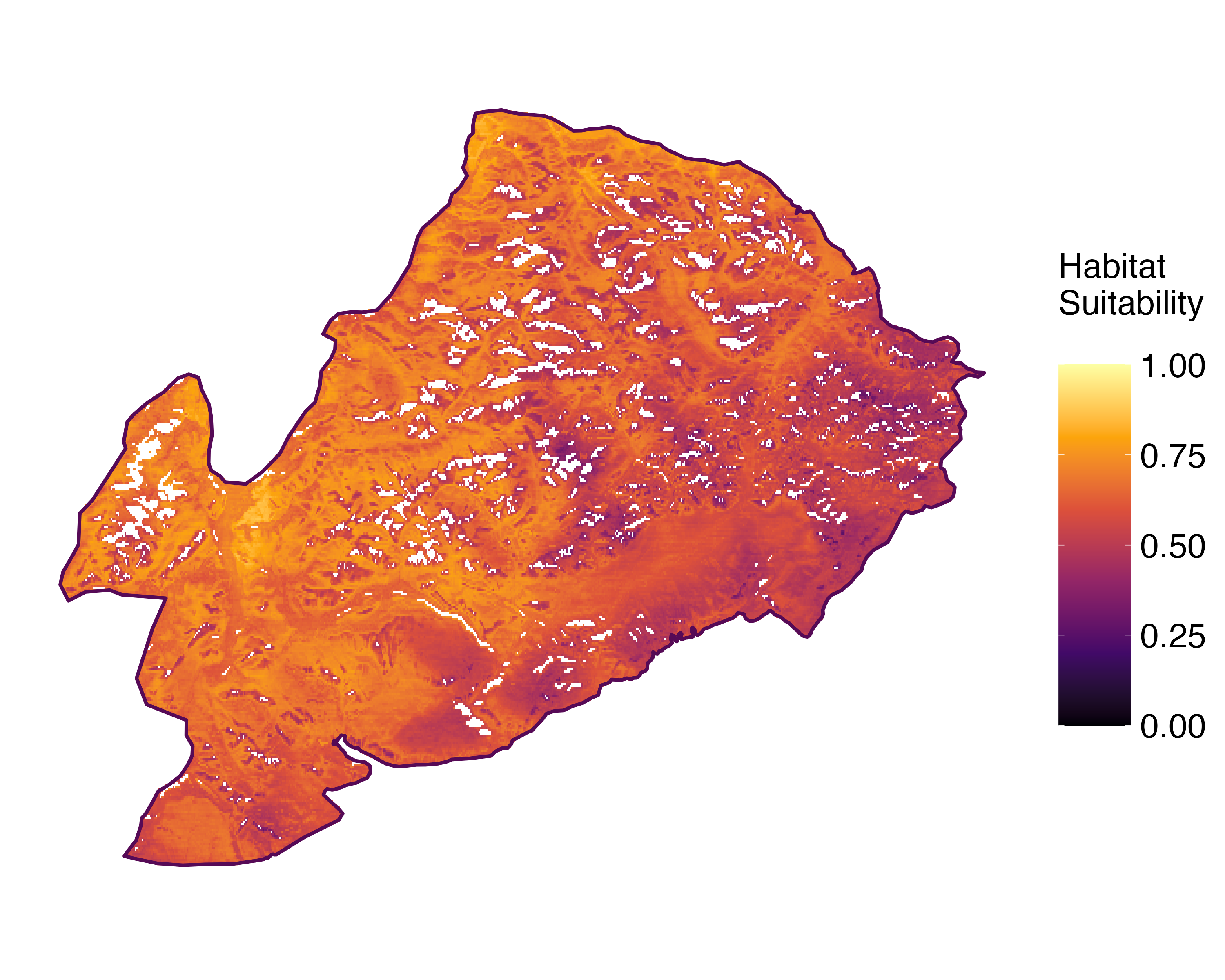 Future prediction (2071-2100) SSP 1-2.6
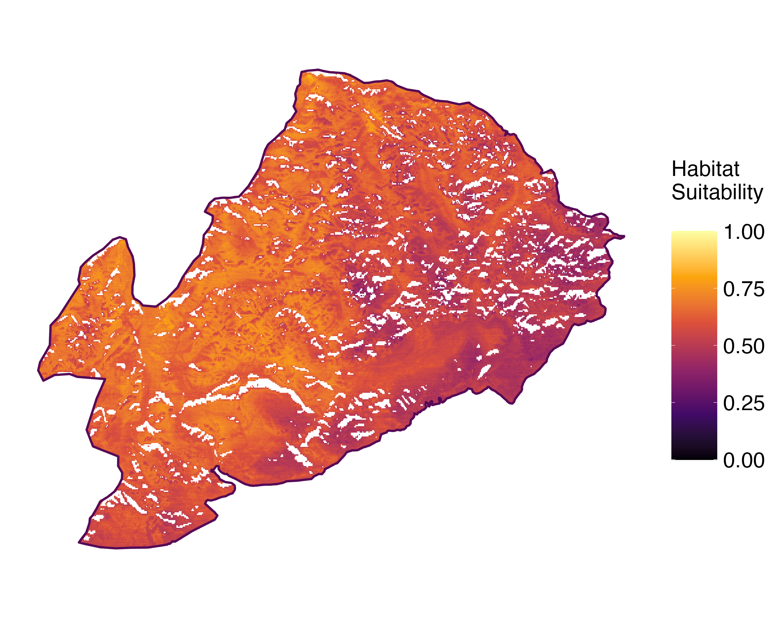 Future prediction (2071-2100) SSP 5-8.5Predictive maps according to Francesconi et al. 2025
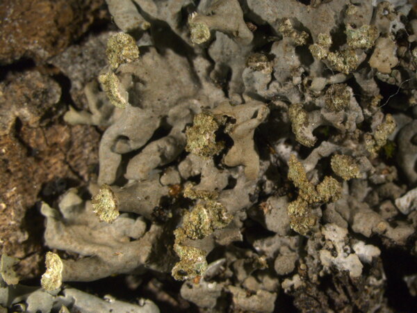
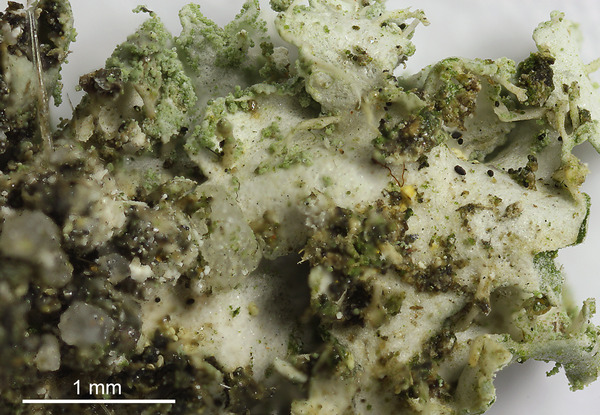
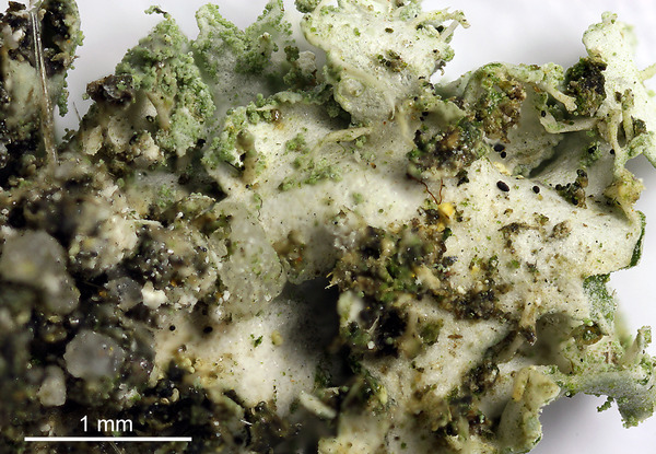
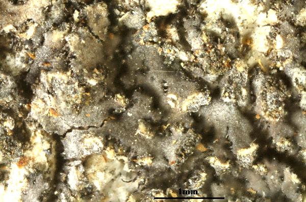
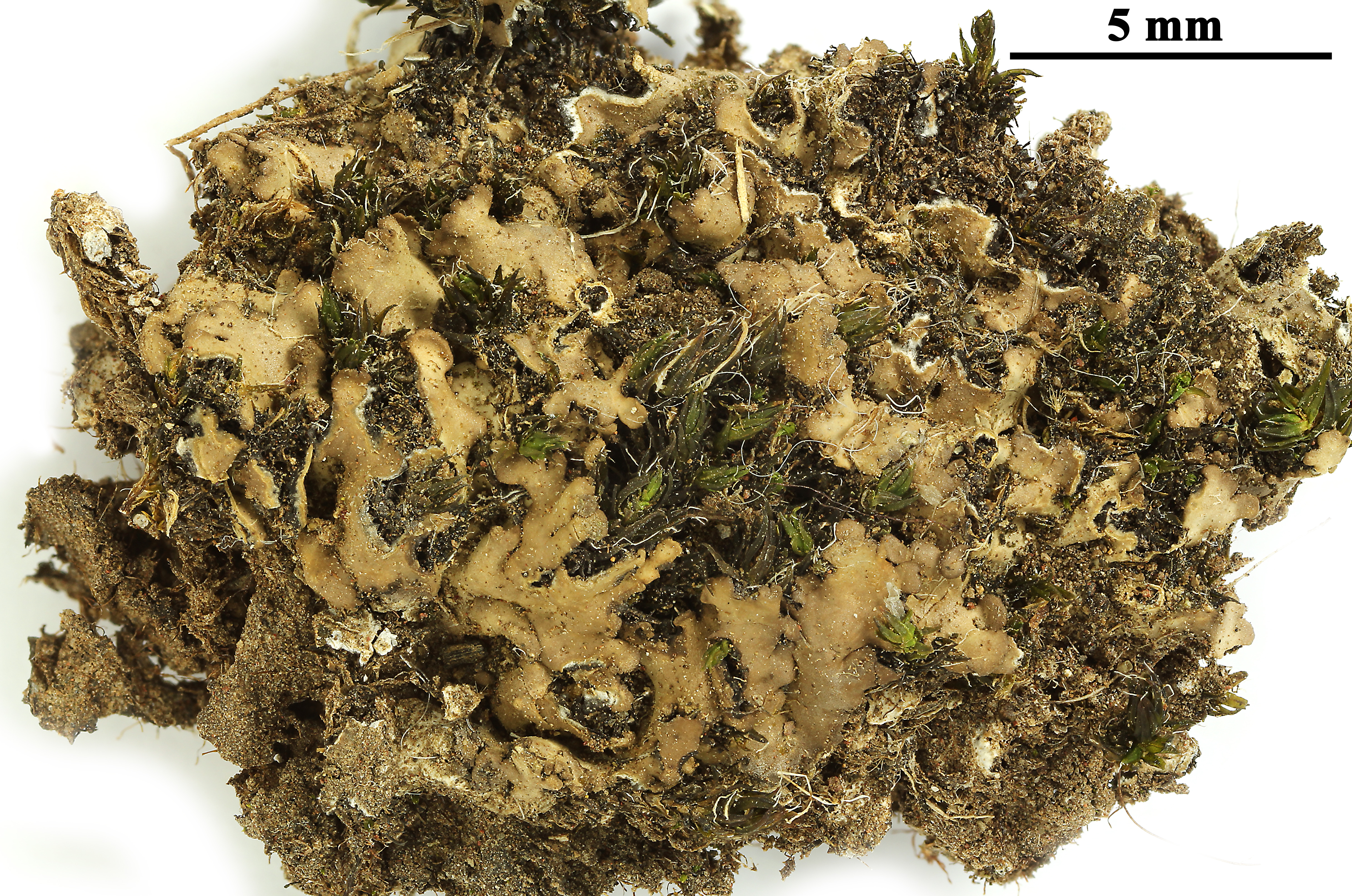
P.L. Nimis; Owner: Department of Life Sciences, University of Trieste
Herbarium: TSB (31391)
2001/12/05
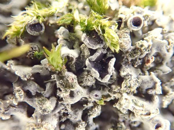
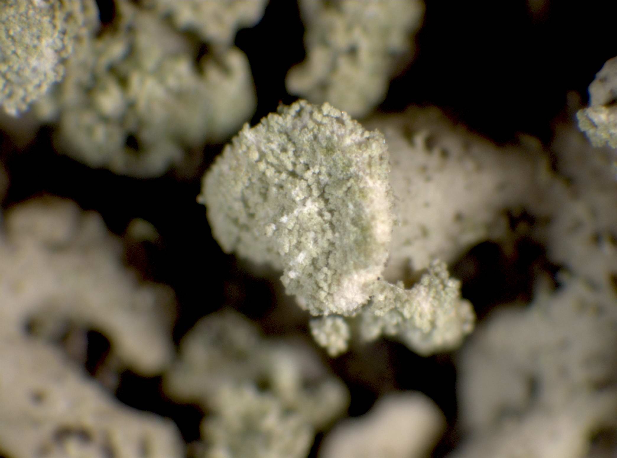
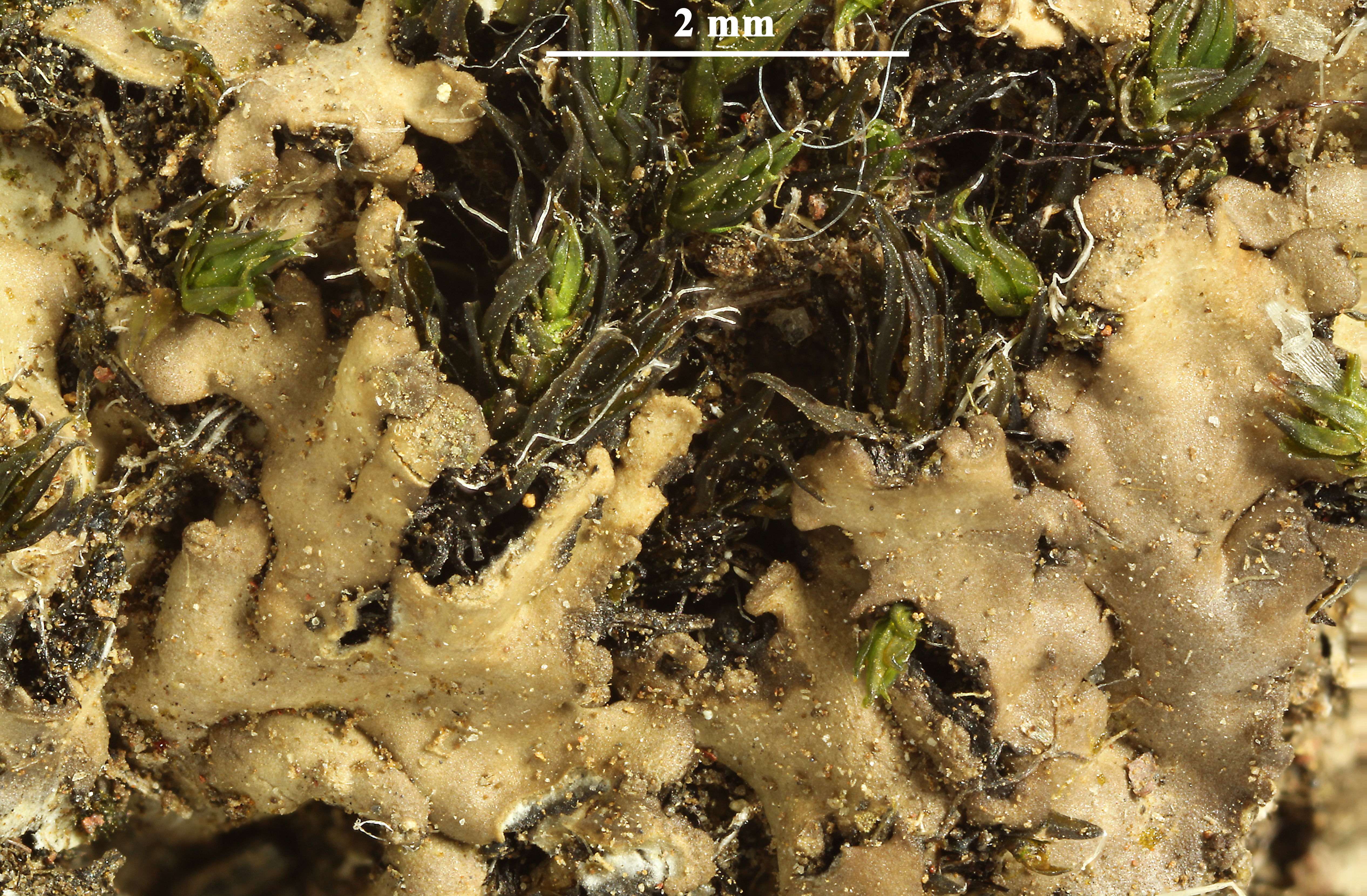
detail of soralium
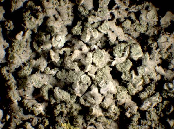
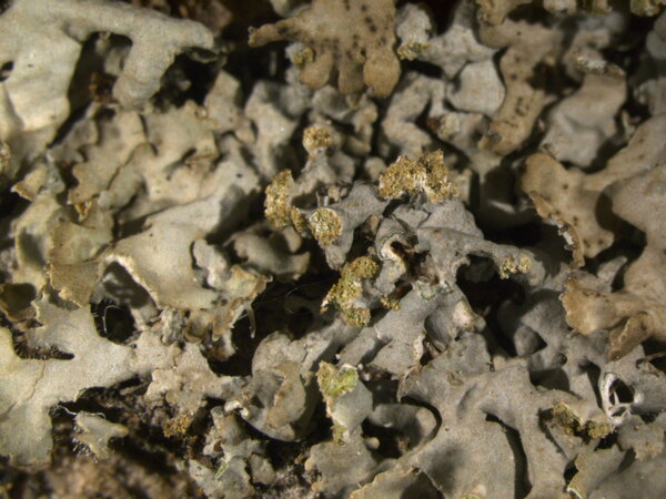
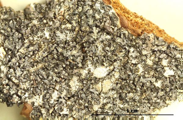
P.L. Nimis; Owner: Department of Life Sciences, University of Trieste
Herbarium: TSB (31391)
2001/12/05

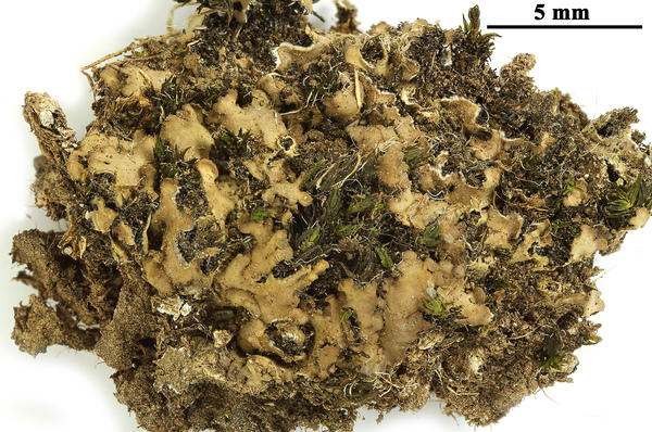
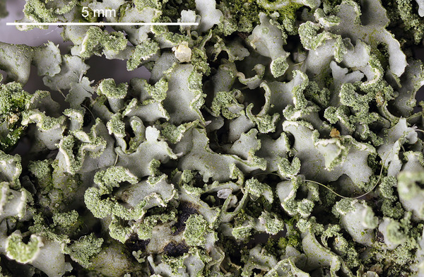
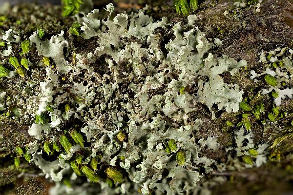
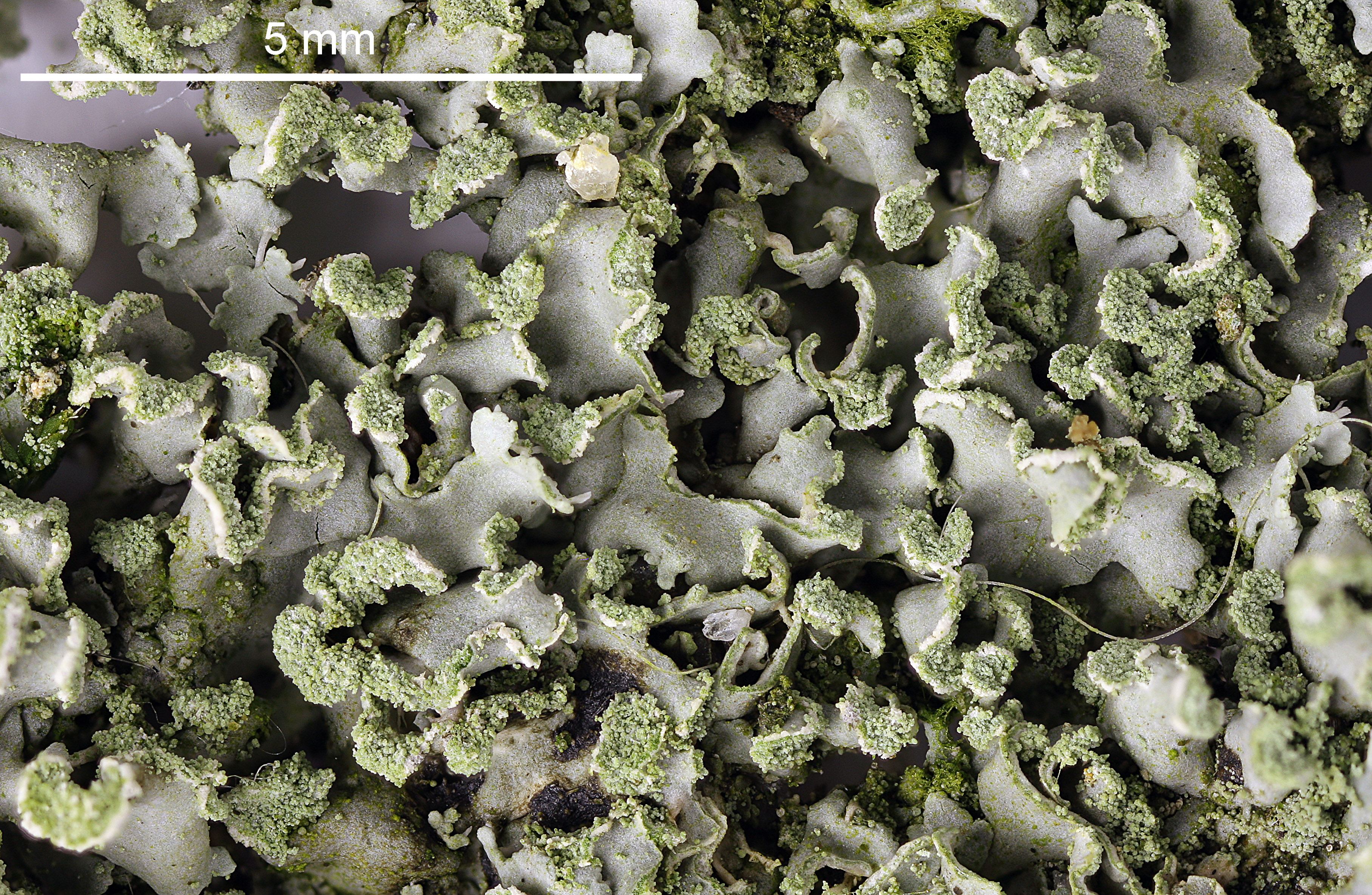
Juri Nascimbene; Owner: Department of Life Sciences, University of Trieste
Italy, Trentino-Alto Adige, Trento, Villa Welsperg, Centro Visitatori del Parco di Paneveggio; altitude: 1030 m
03.04.2009
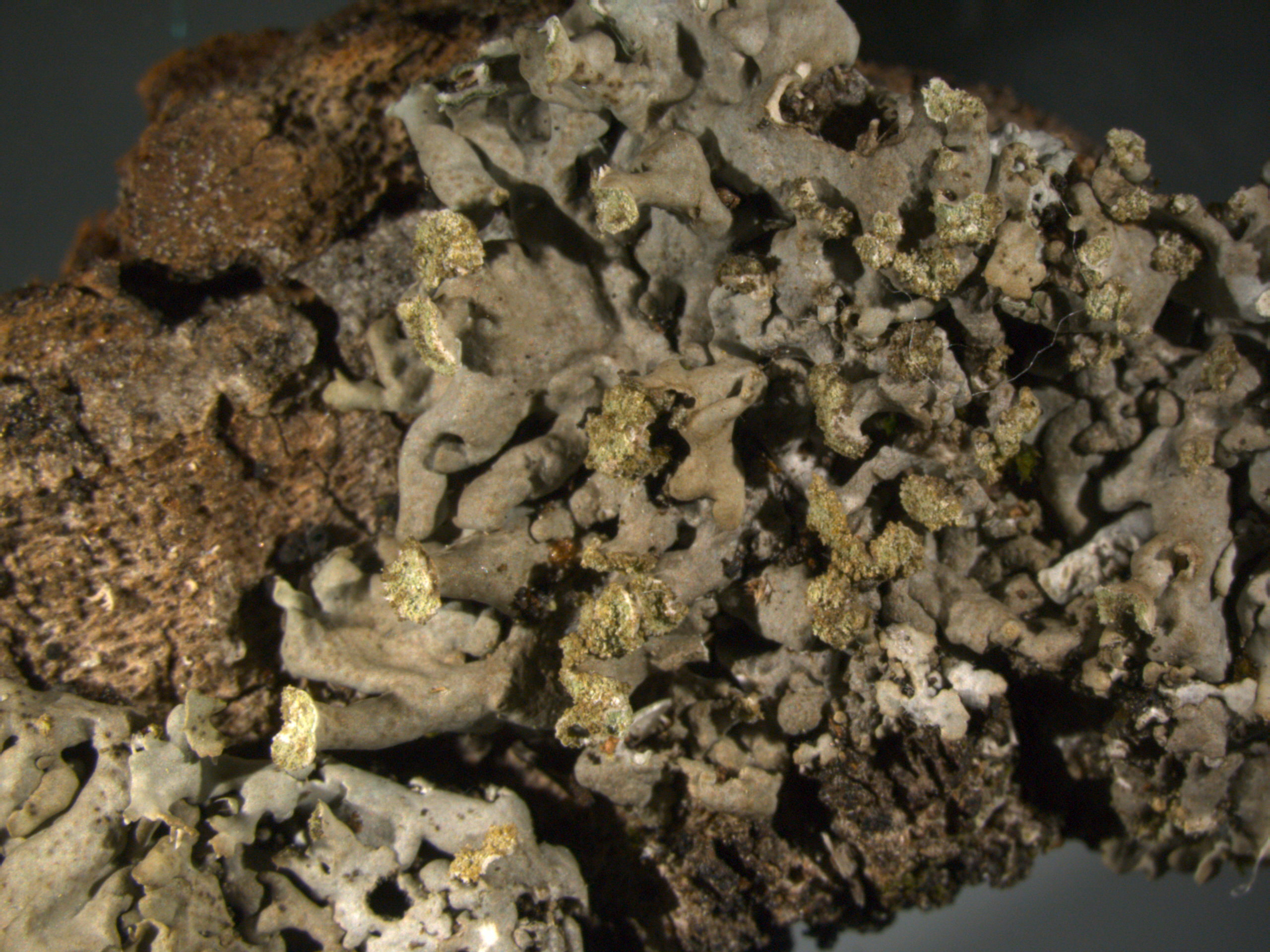
Juri Nascimbene; Owner: Department of Life Sciences, University of Trieste
Italy, Trentino-Alto Adige, Trento, Villa Welsperg, Centro Visitatori del Parco di Paneveggio; altitude: 1030 m
03.04.2009
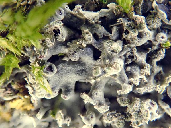
Juri Nascimbene; Owner: Department of Life Sciences, University of Trieste
Italy, Trentino-Alto Adige, Trento, Villa Welsperg, Centro Visitatori del Parco di Paneveggio; altitude: 1030 m
03.04.2009
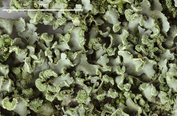
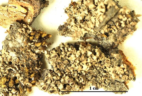
Felix Schumm - CC BY.SA 4.0
[14097], Portugal, Azoren, Terceira, bei Sao Bartholomeu 38°40.482' N, 27°17.586' W, 125 m. Leg. A. Aptroot & F. Schumm, 13.07.2008, det. A. Aptroot.

Felix Schumm - CC BY.SA 4.0
[14097], Portugal, Azoren, Terceira, bei Sao Bartholomeu 38°40.482' N, 27°17.586' W, 125 m. Leg. A. Aptroot & F. Schumm, 13.07.2008, det. A. Aptroot.
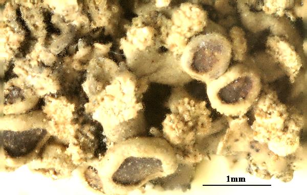
Felix Schumm – CC BY-SA 4.0
[14957], Germany, Baden-Württemberg, Kreis Göppingen, Faurndau, auf Sandsteinmauer der Faurndauer Kirche, 48,70290° N, 9,61455° E, 314 m, 314 m. Leg. F. Schumm & A. Aptroot, 18.09.2009, det. A. Aptroot.
Felix Schumm – CC BY-SA 4.0
[14957], Germany, Baden-Württemberg, Kreis Göppingen, Faurndau, auf Sandsteinmauer der Faurndauer Kirche, 48,70290° N, 9,61455° E, 314 m, 314 m. Leg. F. Schumm & A. Aptroot, 18.09.2009, det. A. Aptroot.
Felix Schumm – CC BY-SA 4.0
[14957], Germany, Baden-Württemberg, Kreis Göppingen, Faurndau, auf Sandsteinmauer der Faurndauer Kirche, 48,70290° N, 9,61455° E, 314 m, 314 m. Leg. F. Schumm & A. Aptroot, 18.09.2009, det. A. Aptroot.
Felix Schumm – CC BY-SA 4.0
[14957], Germany, Baden-Württemberg, Kreis Göppingen, Faurndau, auf Sandsteinmauer der Faurndauer Kirche, 48,70290° N, 9,61455° E, 314 m, 314 m. Leg. F. Schumm & A. Aptroot, 18.09.2009, det. A. Aptroot.
Felix Schumm – CC BY-SA 4.0
[14957], Germany, Baden-Württemberg, Kreis Göppingen, Faurndau, auf Sandsteinmauer der Faurndauer Kirche, 48,70290° N, 9,61455° E, 314 m, 314 m. Leg. F. Schumm & A. Aptroot, 18.09.2009, det. A. Aptroot.
Felix Schumm – CC BY-SA 4.0
[14957], Germany, Baden-Württemberg, Kreis Göppingen, Faurndau, auf Sandsteinmauer der Faurndauer Kirche, 48,70290° N, 9,61455° E, 314 m, 314 m. Leg. F. Schumm & A. Aptroot, 18.09.2009, det. A. Aptroot.

Felix Schumm – CC BY-SA 4.0
[14957], Germany, Baden-Württemberg, Kreis Göppingen, Faurndau, auf Sandsteinmauer der Faurndauer Kirche, 48,70290° N, 9,61455° E, 314 m, 314 m. Leg. F. Schumm & A. Aptroot, 18.09.2009, det. A. Aptroot.
Felix Schumm – CC BY-SA 4.0
[14957], Germany, Baden-Württemberg, Kreis Göppingen, Faurndau, auf Sandsteinmauer der Faurndauer Kirche, 48,70290° N, 9,61455° E, 314 m, 314 m. Leg. F. Schumm & A. Aptroot, 18.09.2009, det. A. Aptroot.

Felix Schumm – CC BY-SA 4.0
[14957], Germany, Baden-Württemberg, Kreis Göppingen, Faurndau, auf Sandsteinmauer der Faurndauer Kirche, 48,70290° N, 9,61455° E, 314 m, 314 m. Leg. F. Schumm & A. Aptroot, 18.09.2009, det. A. Aptroot.
Ulrich Kirschbaum CC BY-SA 4.0 - Source: https://www.thm.de/lse/ulrich-kirschbaum/flechtenbilder
Central Europe: Germany. (Coll/ident: Eichler/Cezanne).
Wolfgang von Brackel - CC BY-4.0
Germany, Bavaria, Pähl bei Weilheim
Wolfgang von Brackel - CC BY-4.0
Germany, Bavaria, Pähl bei Weilheim
Wolfgang von Brackel - CC BY-4.0
Germany, Bavaria, Pähl bei Weilheim
Felix Schumm - CC BY 4.0
[VZ1169], Austria. Stiria. Distr, Radkersburg, ad marginem silvae
fluminis Drau non procul ab Gosdorf, 220 m. As basin Fraxini excelsioris.
Leg. J. Poelt, 18.3.1973. EX A. VEZDA LICHENES SELECTI EXSICCATI
NR. 1169. - As Physcia luganensis
Felix Schumm - CC BY 4.0
[VZ1169], Austria. Stiria. Distr, Radkersburg, ad marginem silvae
fluminis Drau non procul ab Gosdorf, 220 m. As basin Fraxini excelsioris.
Leg. J. Poelt, 18.3.1973. EX A. VEZDA LICHENES SELECTI EXSICCATI
NR. 1169. - As Physcia luganensis
Felix Schumm - CC BY 4.0
[VZ1936], URSS., Transcaucasia, Colchis, distr. Guiripshi, in vicinitate
pagi Obrugvant, in monte Malyi Lakhult, 1700-2000 m. Ad corticem
Aceris. Leg. V. Vašák, 8.6.1981, det. A. Vezda. Ex A. Vezda Lichenes
Selecti Exsiccati Nr. 1936. - As Physcia luganensis
Felix Schumm - CC BY 4.0
[VZ1936], URSS., Transcaucasia, Colchis, distr. Guiripshi, in vicinitate
pagi Obrugvant, in monte Malyi Lakhult, 1700-2000 m. Ad corticem
Aceris. Leg. V. Vašák, 8.6.1981, det. A. Vezda. Ex A. Vezda Lichenes
Selecti Exsiccati Nr. 1936. - As Physcia luganensis
Growth form: Foliose, narrow lobed
Substrata: bark and rocks
Photobiont: green algae other than Trentepohlia
Reproductive strategy: mainly asexual, by soredia, or soredia-like structures (e.g. blastidia)
Commonnes-rarity: (info)
Alpine belt: absent
Subalpine belt: absent
Montane belt: extremely rare
Dry submediterranean belt: rather rare
Humid submediterranean belt: rather rare
Padanian area: extremely rare
pH of the substrata:
| 1 | 2 | 3 | 4 | 5 |
Solar irradiation:
| 1 | 2 | 3 | 4 | 5 |
Aridity:
| 1 | 2 | 3 | 4 | 5 |
Eutrophication:
| 1 | 2 | 3 | 4 | 5 |
Poleotolerance:
| 0 | 1 | 2 | 3 |
Altitudinal distribution:
| 1 | 2 | 3 | 4 | 5 | 6 |
Rarity
absent
extremely rare
very rare
rare
rather rare
rather common
common
very common
extremely common
Loading data...
Occurrence data
Predictive map
Current prediction (1981-2010)Future prediction (2071-2100) SSP 1-2.6Future prediction (2071-2100) SSP 5-8.5Predictive maps according to Francesconi et al. 2025
P.L. Nimis; Owner: Department of Life Sciences, University of Trieste
Herbarium: TSB (31391)
2001/12/05
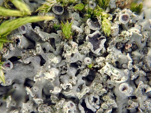
detail of soralium

P.L. Nimis; Owner: Department of Life Sciences, University of Trieste
Herbarium: TSB (31391)
2001/12/05
Juri Nascimbene; Owner: Department of Life Sciences, University of Trieste
Italy, Trentino-Alto Adige, Trento, Villa Welsperg, Centro Visitatori del Parco di Paneveggio; altitude: 1030 m
03.04.2009

Juri Nascimbene; Owner: Department of Life Sciences, University of Trieste
Italy, Trentino-Alto Adige, Trento, Villa Welsperg, Centro Visitatori del Parco di Paneveggio; altitude: 1030 m
03.04.2009

Juri Nascimbene; Owner: Department of Life Sciences, University of Trieste
Italy, Trentino-Alto Adige, Trento, Villa Welsperg, Centro Visitatori del Parco di Paneveggio; altitude: 1030 m
03.04.2009
Felix Schumm - CC BY.SA 4.0
[14097], Portugal, Azoren, Terceira, bei Sao Bartholomeu 38°40.482' N, 27°17.586' W, 125 m. Leg. A. Aptroot & F. Schumm, 13.07.2008, det. A. Aptroot.
Felix Schumm - CC BY.SA 4.0
[14097], Portugal, Azoren, Terceira, bei Sao Bartholomeu 38°40.482' N, 27°17.586' W, 125 m. Leg. A. Aptroot & F. Schumm, 13.07.2008, det. A. Aptroot.

Felix Schumm – CC BY-SA 4.0
[14957], Germany, Baden-Württemberg, Kreis Göppingen, Faurndau, auf Sandsteinmauer der Faurndauer Kirche, 48,70290° N, 9,61455° E, 314 m, 314 m. Leg. F. Schumm & A. Aptroot, 18.09.2009, det. A. Aptroot.
Felix Schumm – CC BY-SA 4.0
[14957], Germany, Baden-Württemberg, Kreis Göppingen, Faurndau, auf Sandsteinmauer der Faurndauer Kirche, 48,70290° N, 9,61455° E, 314 m, 314 m. Leg. F. Schumm & A. Aptroot, 18.09.2009, det. A. Aptroot.

Felix Schumm – CC BY-SA 4.0
[14957], Germany, Baden-Württemberg, Kreis Göppingen, Faurndau, auf Sandsteinmauer der Faurndauer Kirche, 48,70290° N, 9,61455° E, 314 m, 314 m. Leg. F. Schumm & A. Aptroot, 18.09.2009, det. A. Aptroot.

Felix Schumm – CC BY-SA 4.0
[14957], Germany, Baden-Württemberg, Kreis Göppingen, Faurndau, auf Sandsteinmauer der Faurndauer Kirche, 48,70290° N, 9,61455° E, 314 m, 314 m. Leg. F. Schumm & A. Aptroot, 18.09.2009, det. A. Aptroot.

Felix Schumm – CC BY-SA 4.0
[14957], Germany, Baden-Württemberg, Kreis Göppingen, Faurndau, auf Sandsteinmauer der Faurndauer Kirche, 48,70290° N, 9,61455° E, 314 m, 314 m. Leg. F. Schumm & A. Aptroot, 18.09.2009, det. A. Aptroot.
Felix Schumm – CC BY-SA 4.0
[14957], Germany, Baden-Württemberg, Kreis Göppingen, Faurndau, auf Sandsteinmauer der Faurndauer Kirche, 48,70290° N, 9,61455° E, 314 m, 314 m. Leg. F. Schumm & A. Aptroot, 18.09.2009, det. A. Aptroot.
Felix Schumm – CC BY-SA 4.0
[14957], Germany, Baden-Württemberg, Kreis Göppingen, Faurndau, auf Sandsteinmauer der Faurndauer Kirche, 48,70290° N, 9,61455° E, 314 m, 314 m. Leg. F. Schumm & A. Aptroot, 18.09.2009, det. A. Aptroot.
Felix Schumm – CC BY-SA 4.0
[14957], Germany, Baden-Württemberg, Kreis Göppingen, Faurndau, auf Sandsteinmauer der Faurndauer Kirche, 48,70290° N, 9,61455° E, 314 m, 314 m. Leg. F. Schumm & A. Aptroot, 18.09.2009, det. A. Aptroot.
Felix Schumm – CC BY-SA 4.0
[14957], Germany, Baden-Württemberg, Kreis Göppingen, Faurndau, auf Sandsteinmauer der Faurndauer Kirche, 48,70290° N, 9,61455° E, 314 m, 314 m. Leg. F. Schumm & A. Aptroot, 18.09.2009, det. A. Aptroot.
Ulrich Kirschbaum CC BY-SA 4.0 - Source: https://www.thm.de/lse/ulrich-kirschbaum/flechtenbilder
Central Europe: Germany. (Coll/ident: Eichler/Cezanne).

Wolfgang von Brackel - CC BY-4.0
Germany, Bavaria, Pähl bei Weilheim

Wolfgang von Brackel - CC BY-4.0
Germany, Bavaria, Pähl bei Weilheim

Wolfgang von Brackel - CC BY-4.0
Germany, Bavaria, Pähl bei Weilheim

Felix Schumm - CC BY 4.0
[VZ1169], Austria. Stiria. Distr, Radkersburg, ad marginem silvae fluminis Drau non procul ab Gosdorf, 220 m. As basin Fraxini excelsioris. Leg. J. Poelt, 18.3.1973. EX A. VEZDA LICHENES SELECTI EXSICCATI NR. 1169. - As Physcia luganensis

Felix Schumm - CC BY 4.0
[VZ1169], Austria. Stiria. Distr, Radkersburg, ad marginem silvae fluminis Drau non procul ab Gosdorf, 220 m. As basin Fraxini excelsioris. Leg. J. Poelt, 18.3.1973. EX A. VEZDA LICHENES SELECTI EXSICCATI NR. 1169. - As Physcia luganensis

Felix Schumm - CC BY 4.0
[VZ1936], URSS., Transcaucasia, Colchis, distr. Guiripshi, in vicinitate pagi Obrugvant, in monte Malyi Lakhult, 1700-2000 m. Ad corticem Aceris. Leg. V. Vašák, 8.6.1981, det. A. Vezda. Ex A. Vezda Lichenes Selecti Exsiccati Nr. 1936. - As Physcia luganensis


