
Porina aenea (Wallr.) Zahlbr.
Cat. Lich. Univ., 1: 363, 1922. Basionym: Verrucaria aenea Wallr. - Fl. Crypt. Germ., 3: 299, 1831.
Synonyms: Porina carpinea (Ach.) Zahlbr.; Porina chlorotica var. carpinea (Ach.) Keissl.; Pseudosagedia aenea (Ach.) Hafellner & Kalb; Pyrenula carpinea (Ach.) Trevis.; Sagedia abietina Körb.; Sagedia aenea (Wallr.) Körb.; Sagedia carpinea (Ach.) A. Massal.; Sagedia chloromelaena A. Massal.; Sagedia erumpens A. Massal.; Spermatodium aeneum (Wallr.) Trevis.; Spermatodium carpineum (Ach.) Trevis.; Spermatodium chloromelaenum (A. Massal.) Trevis.; Spermatodium erumpens (A. Massal.) Trevis.; Trichothelium aeneum (Wallr.) R.C. Harris; Verrucaria carpinea Pers. ex Ach.; Verrucaria erumpens (A. Massal.) Garov.
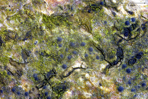
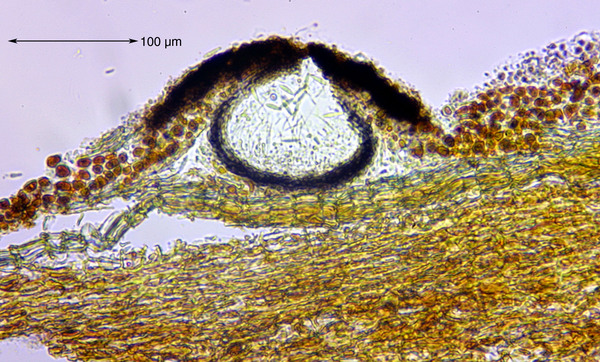
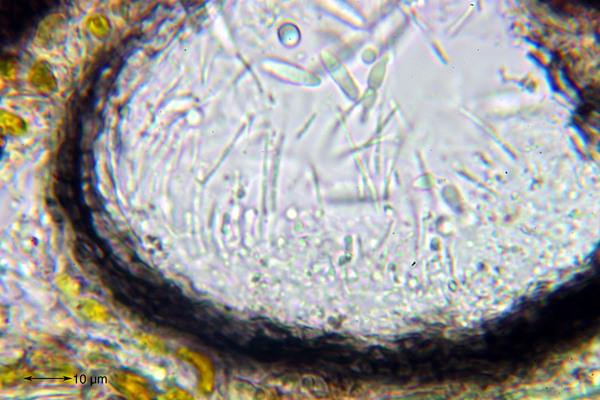
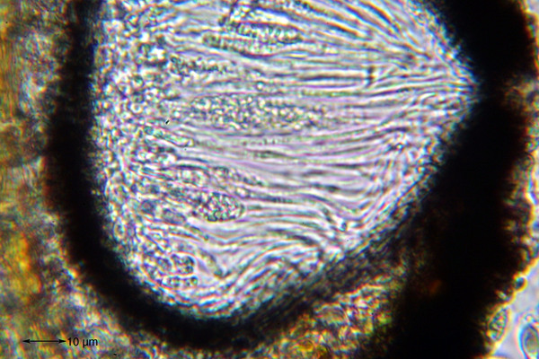
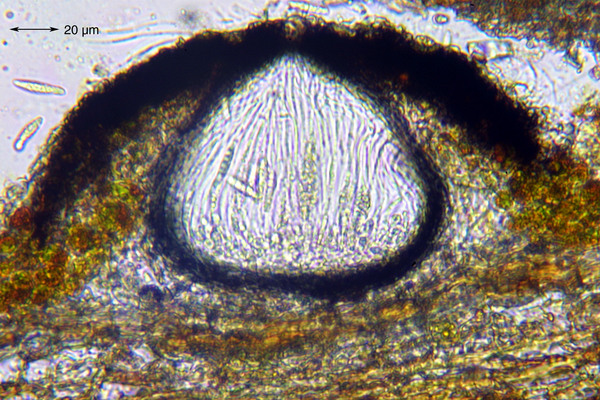
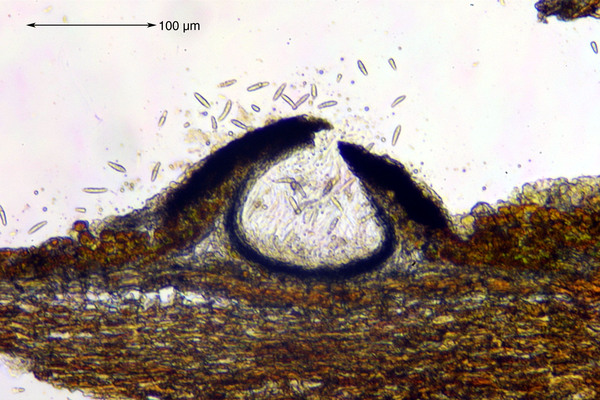
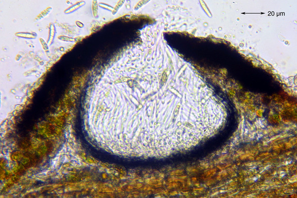
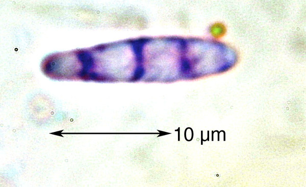
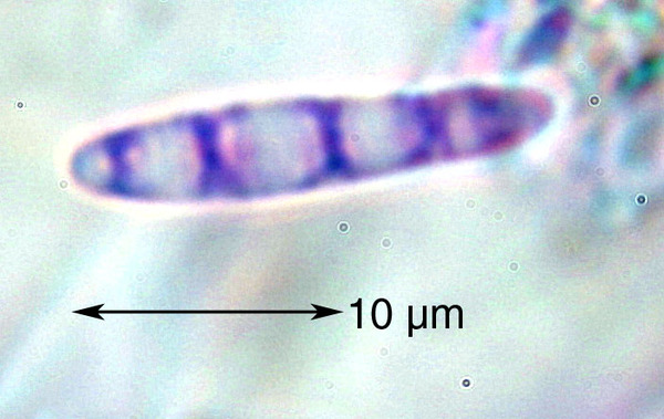
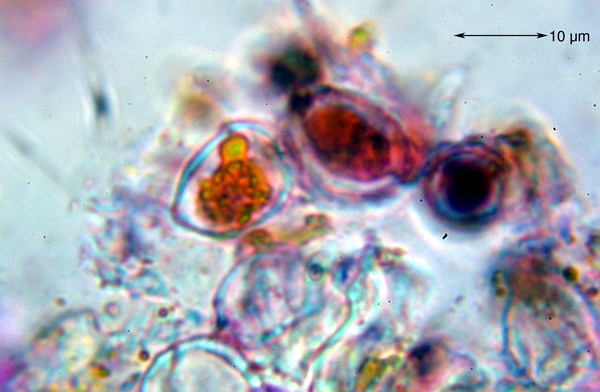
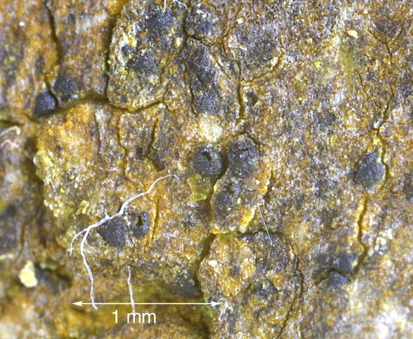
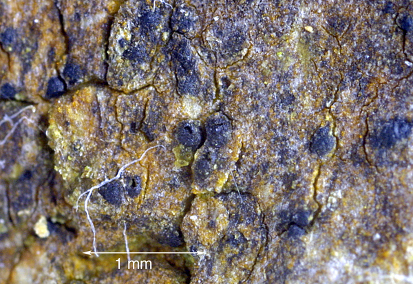
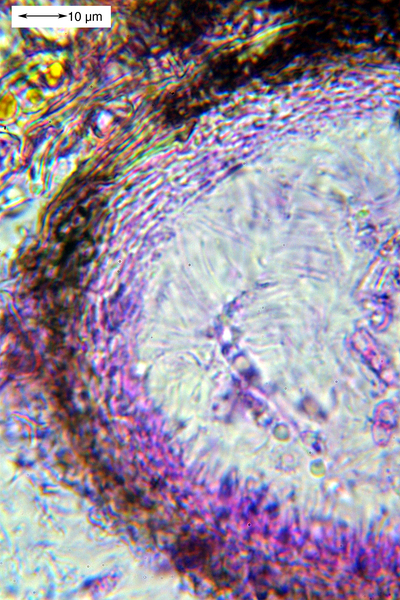
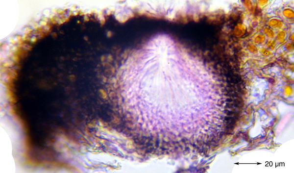
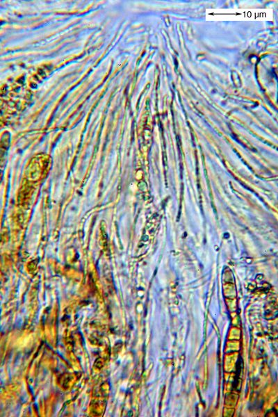
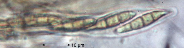
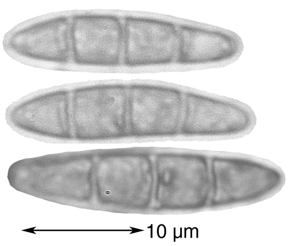
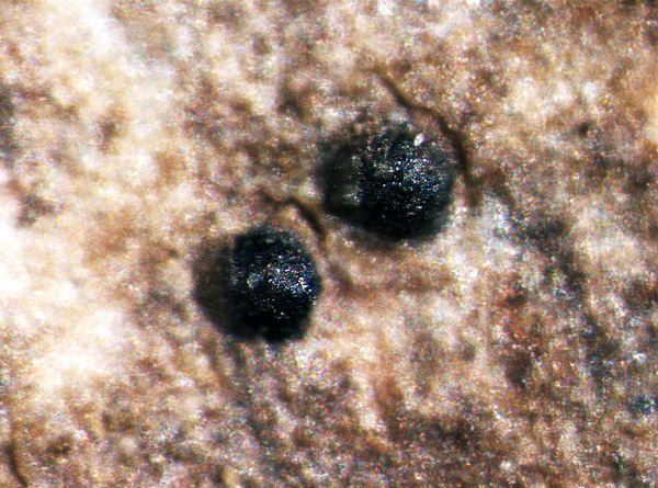
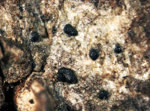
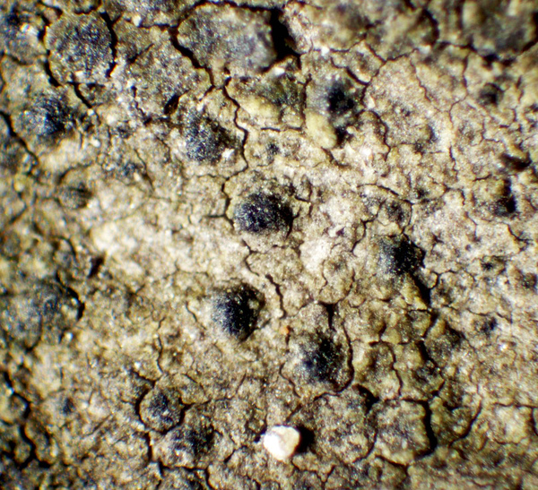
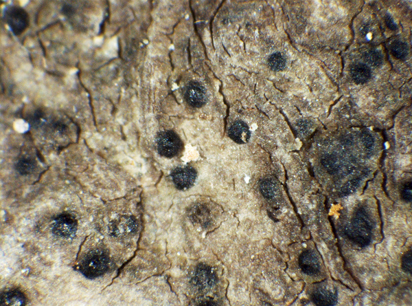
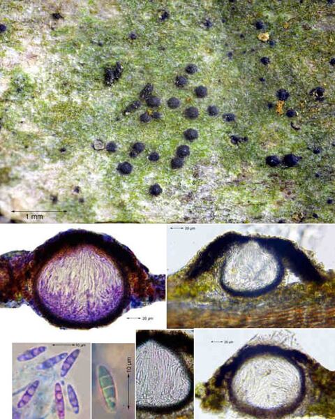
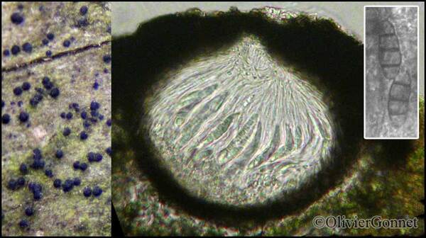
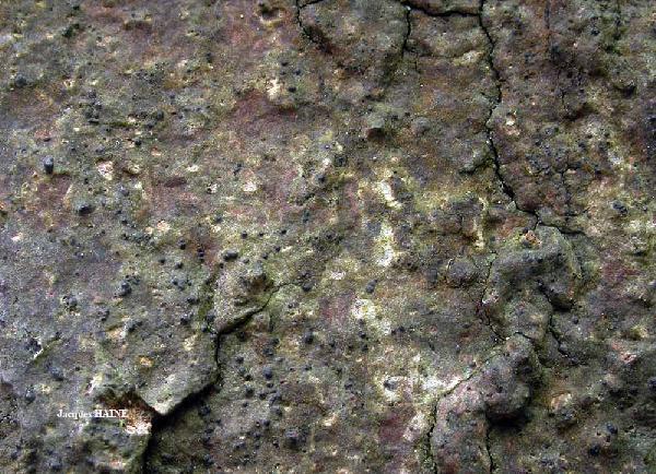
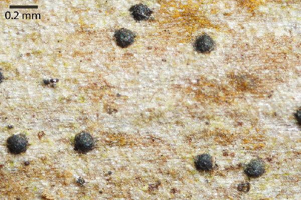
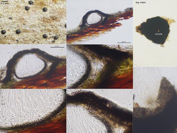
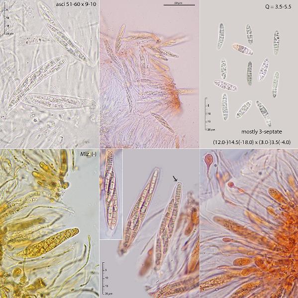
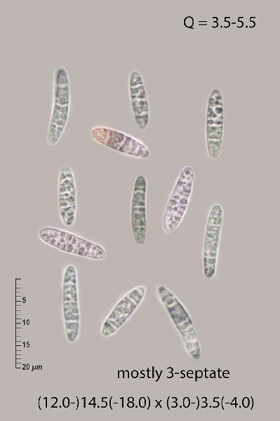
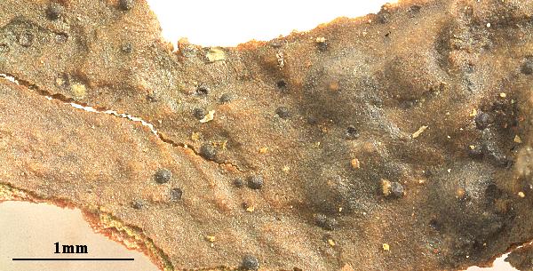
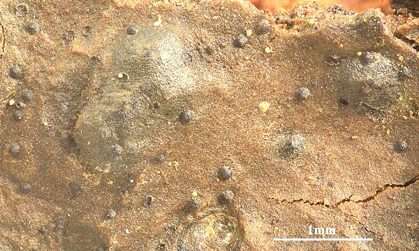
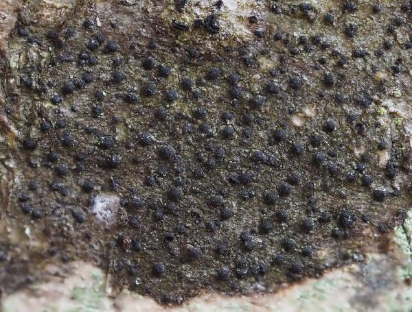
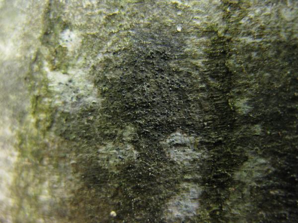
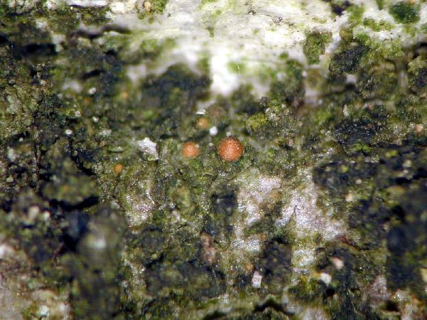
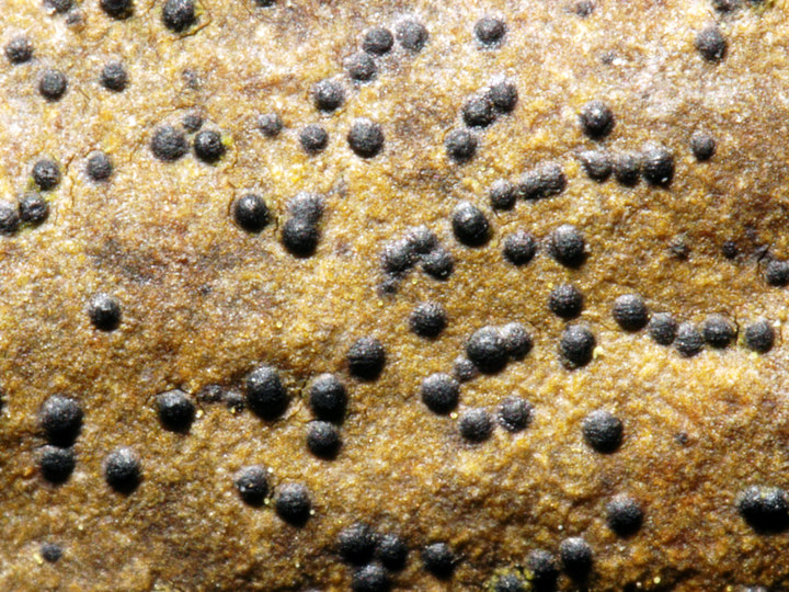
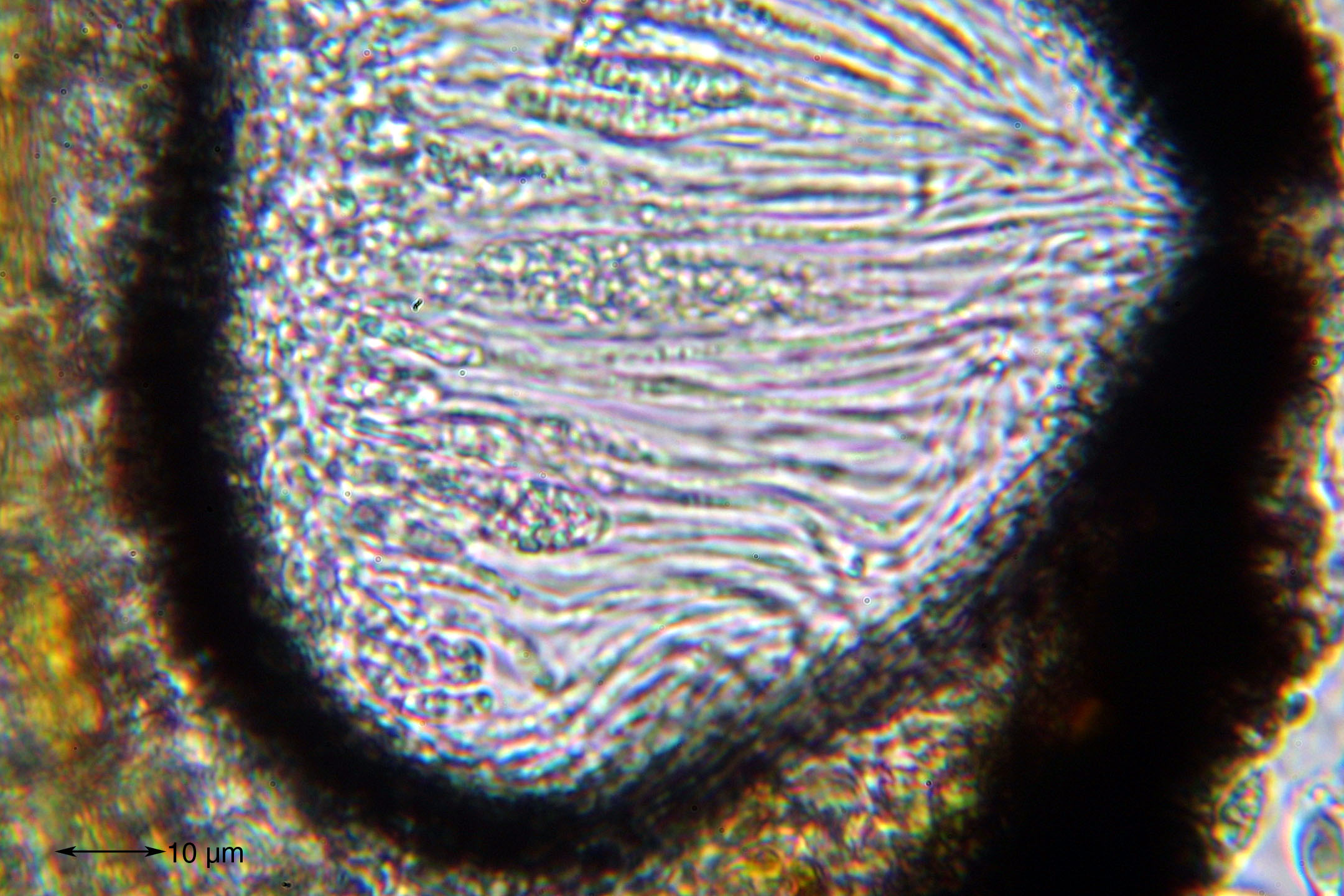
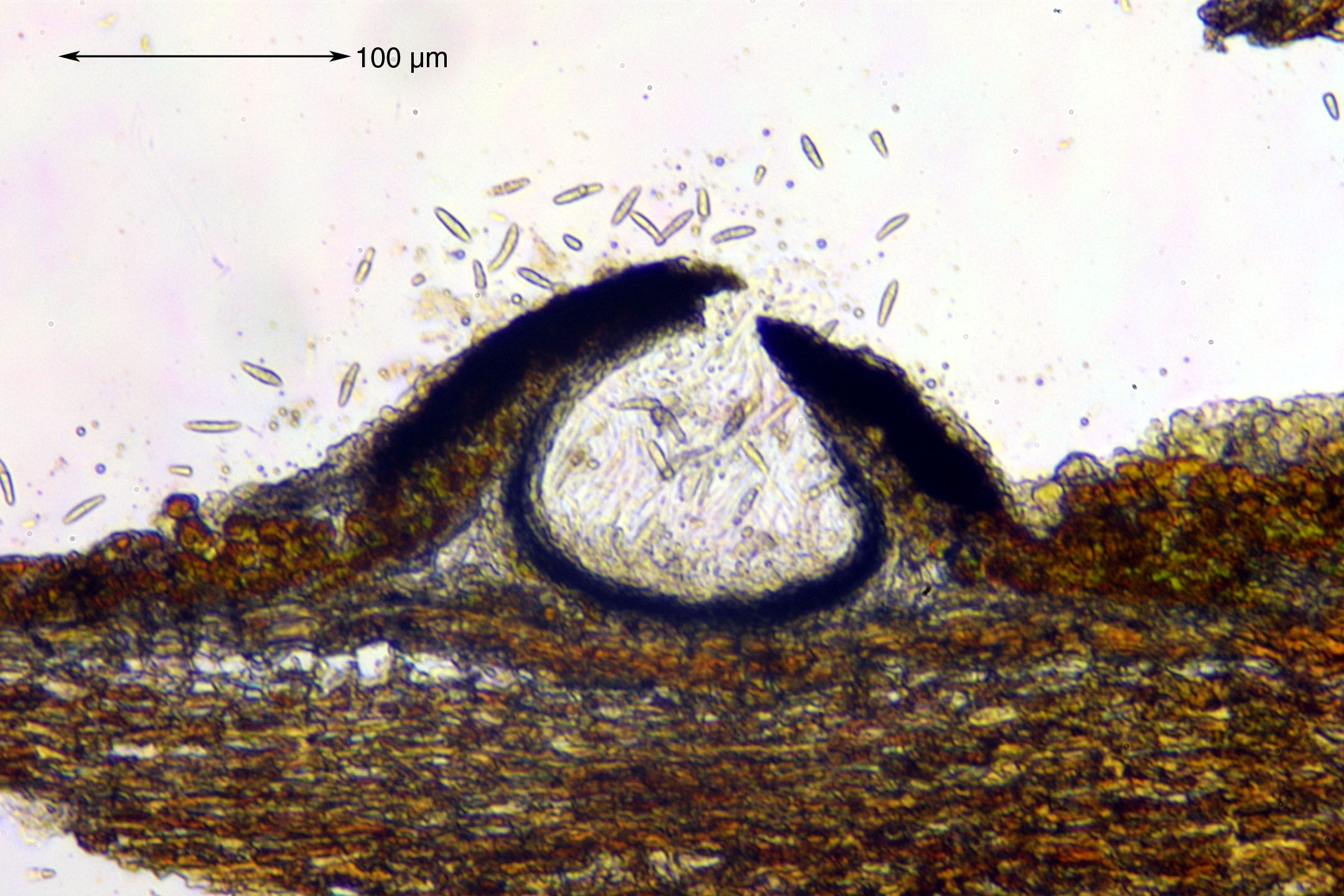
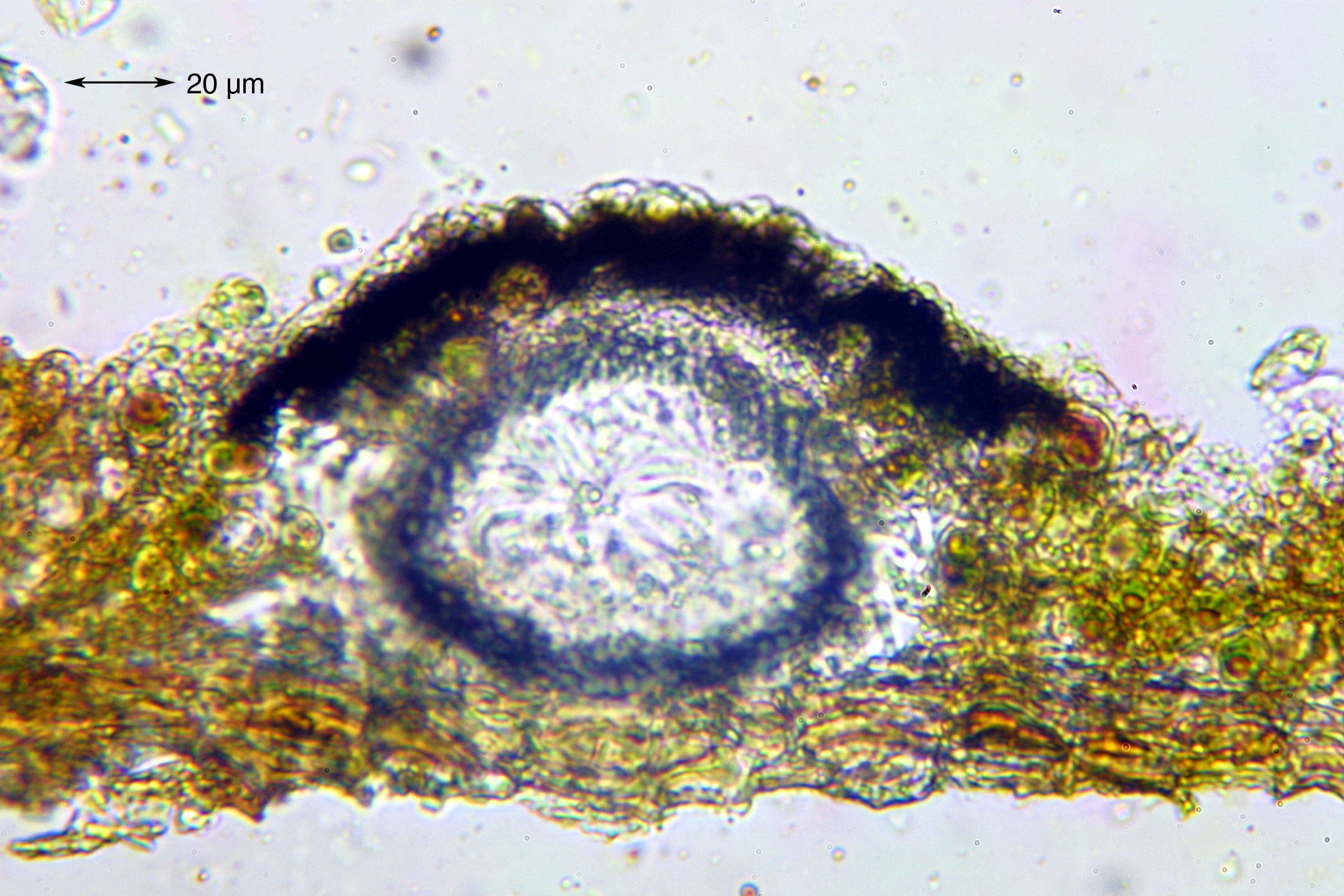
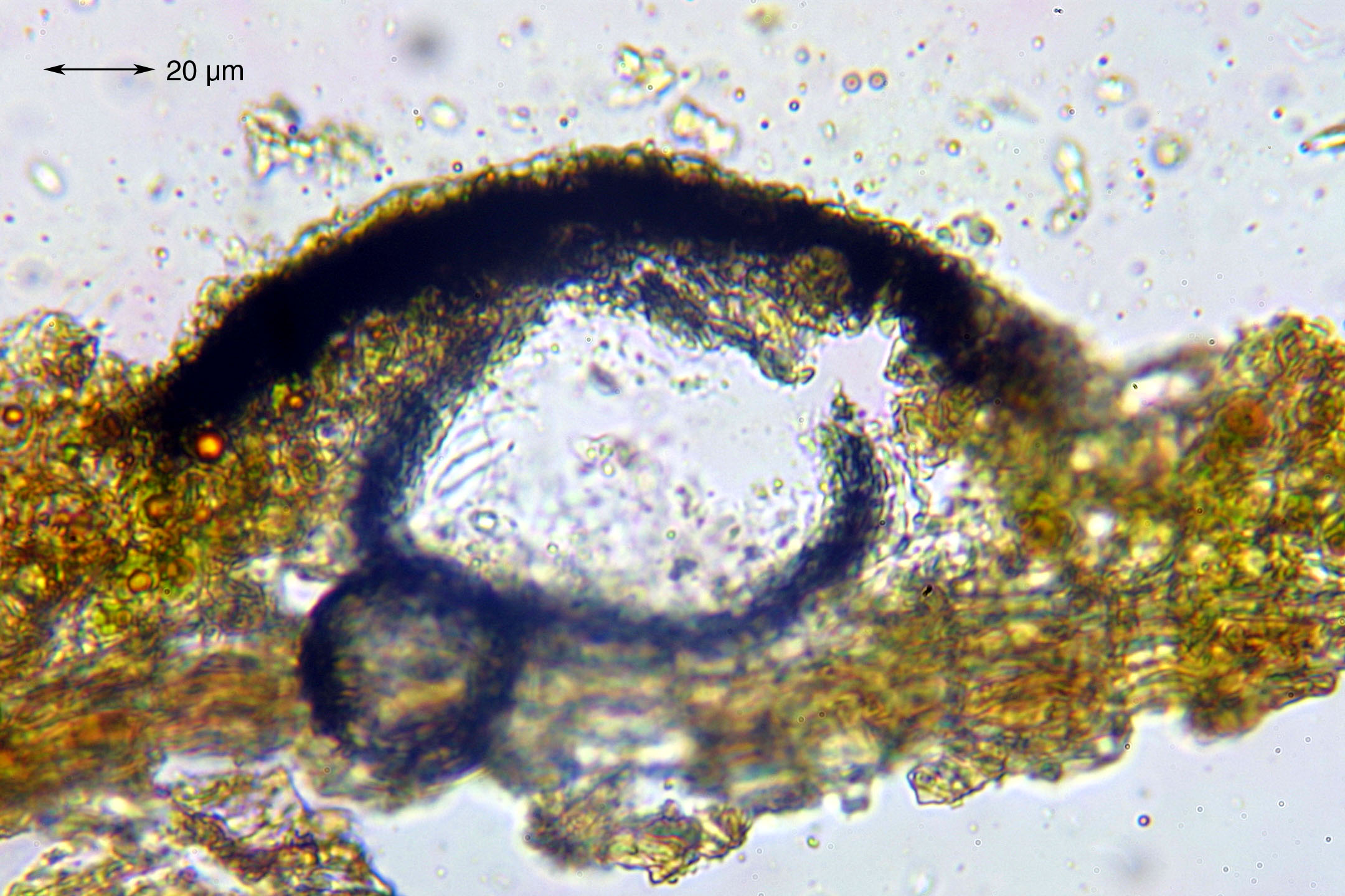
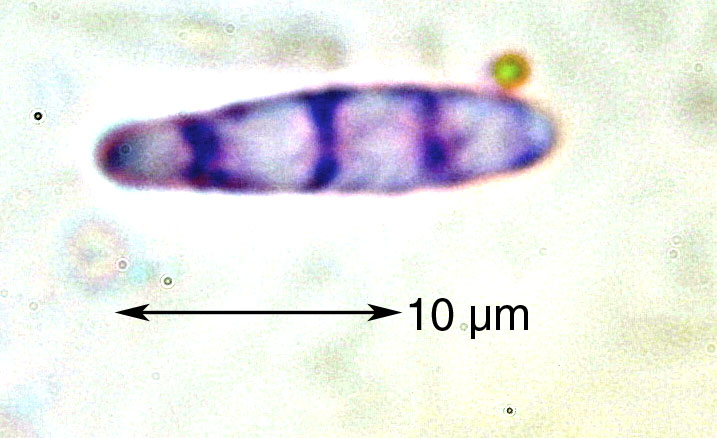
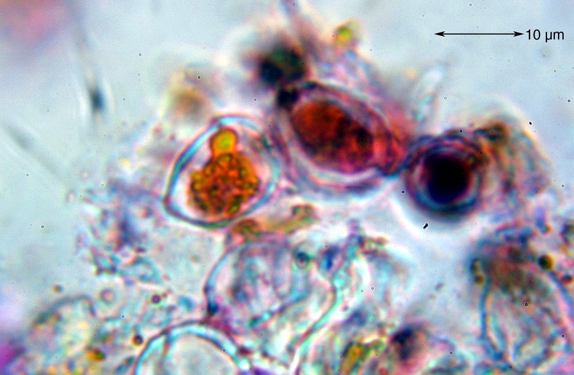
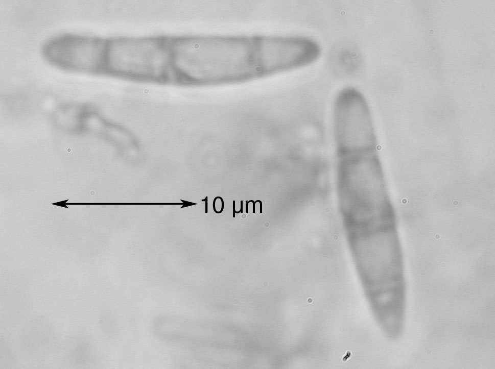
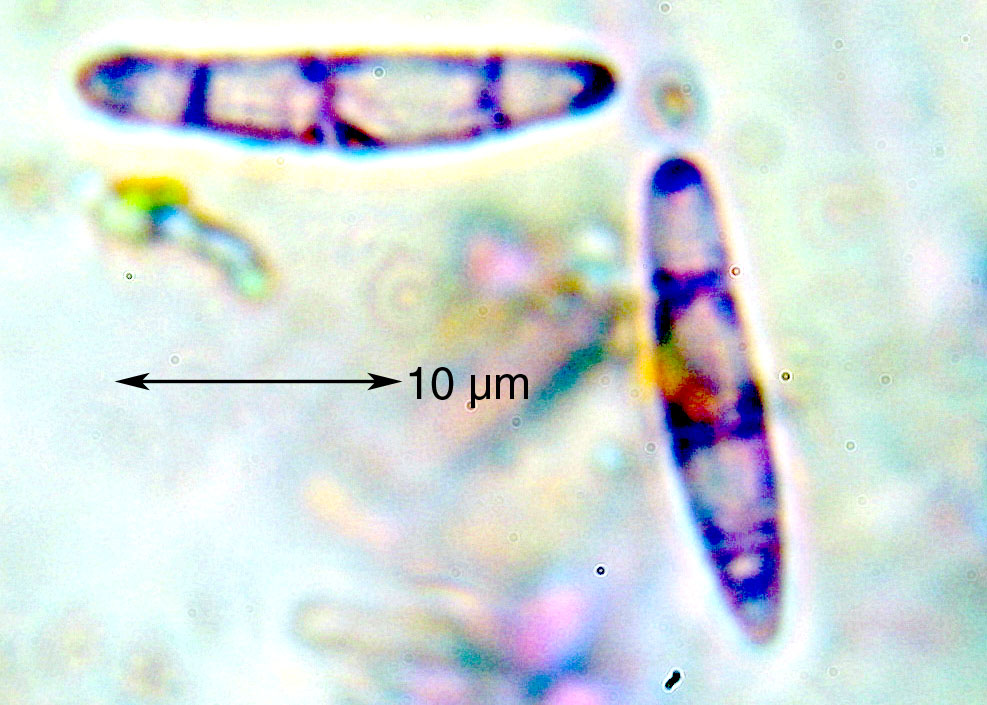
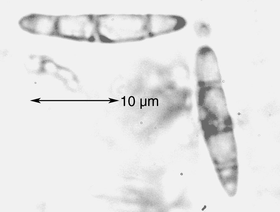
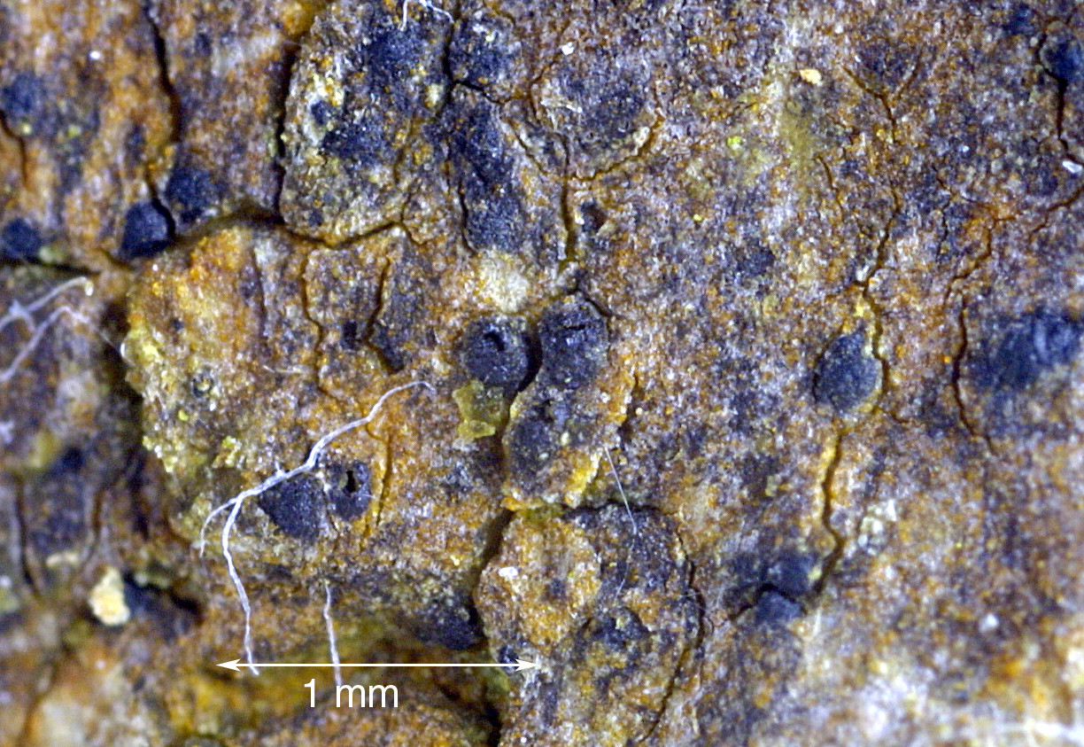
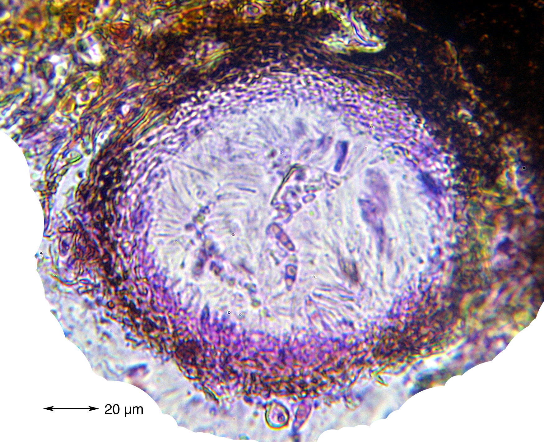
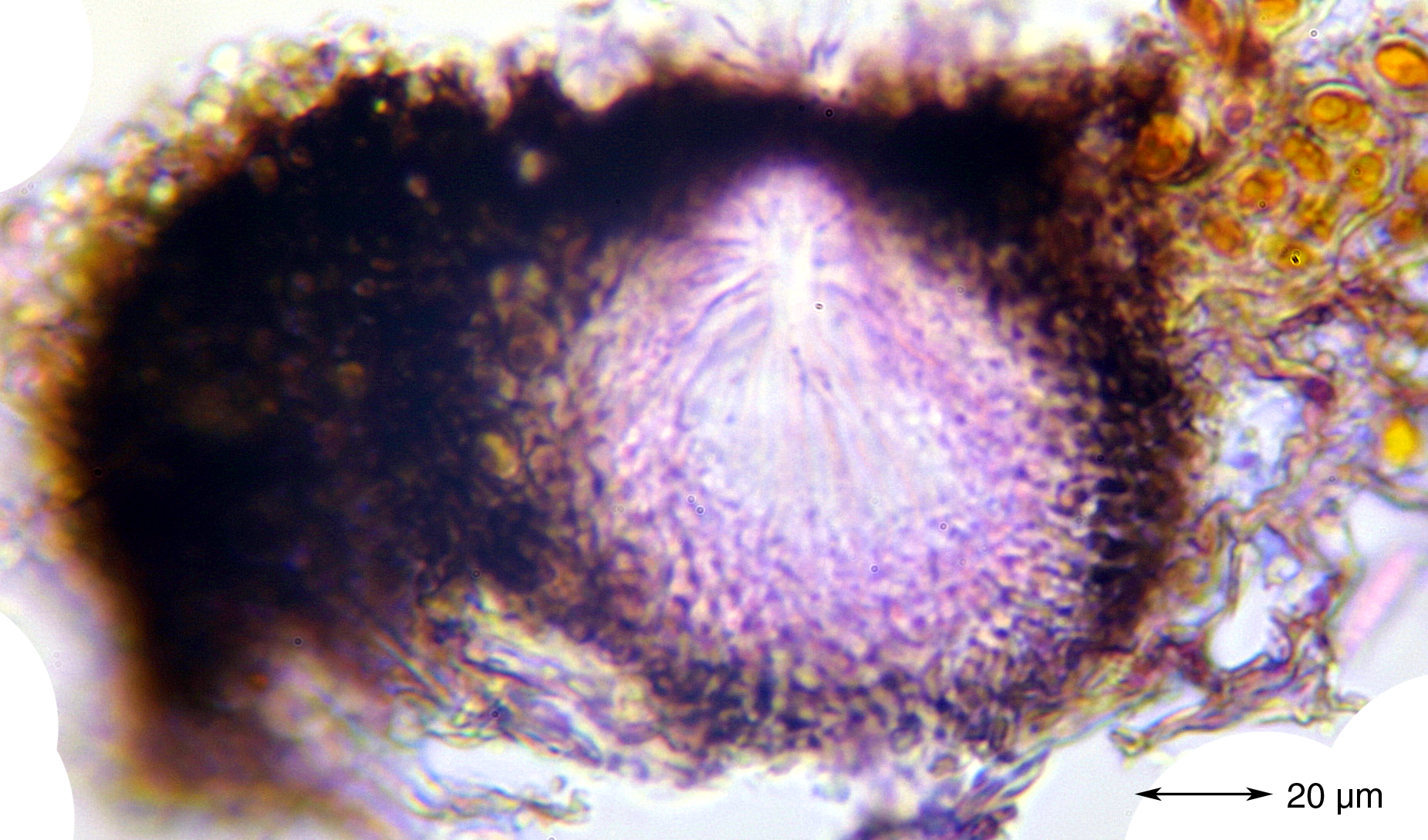
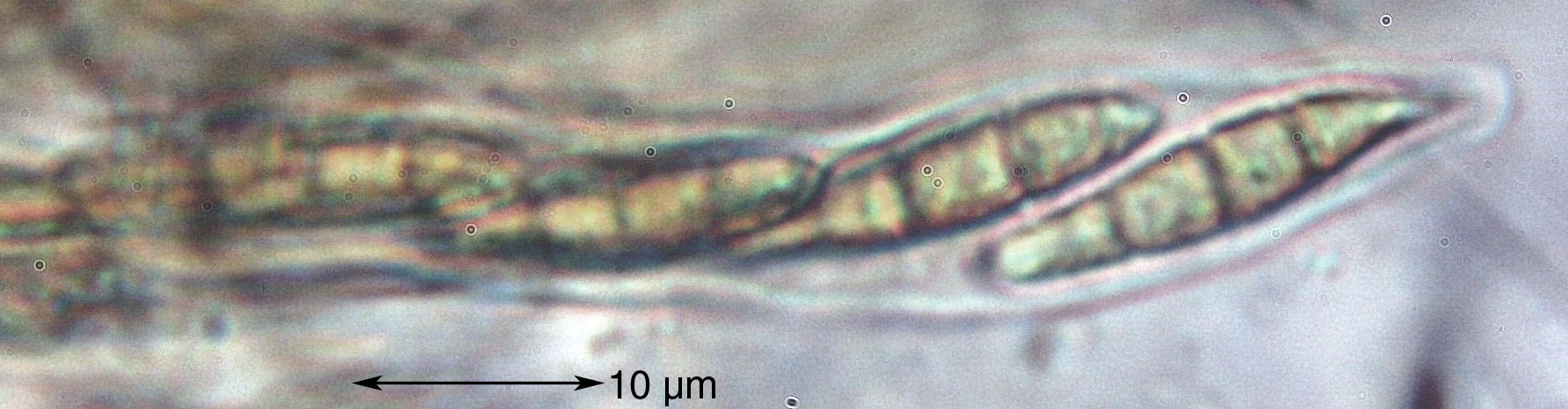
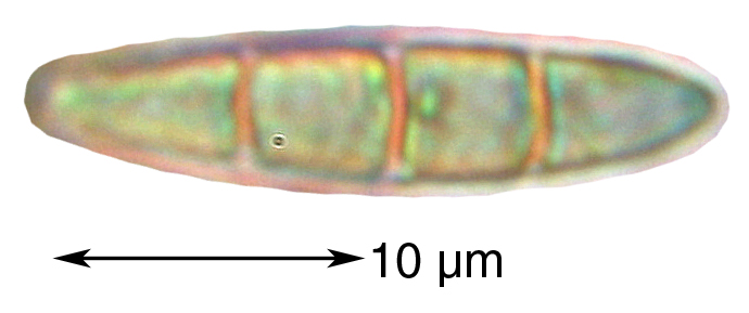
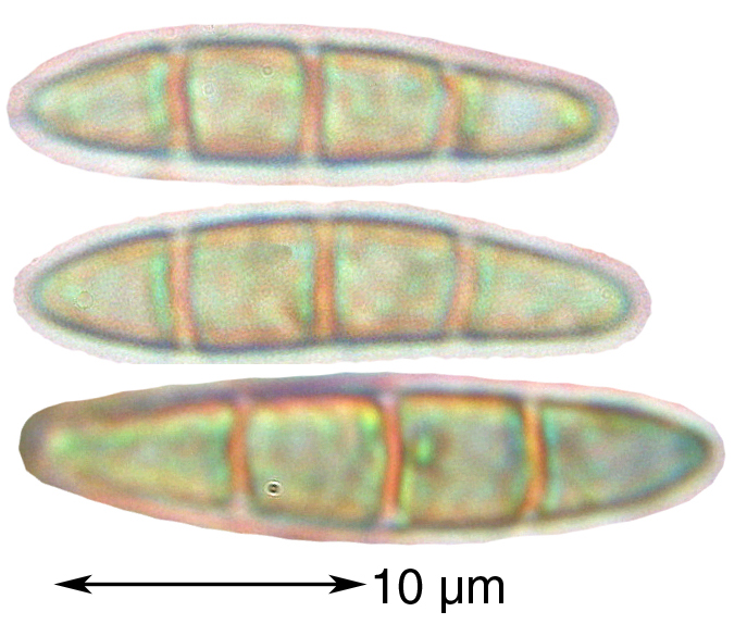
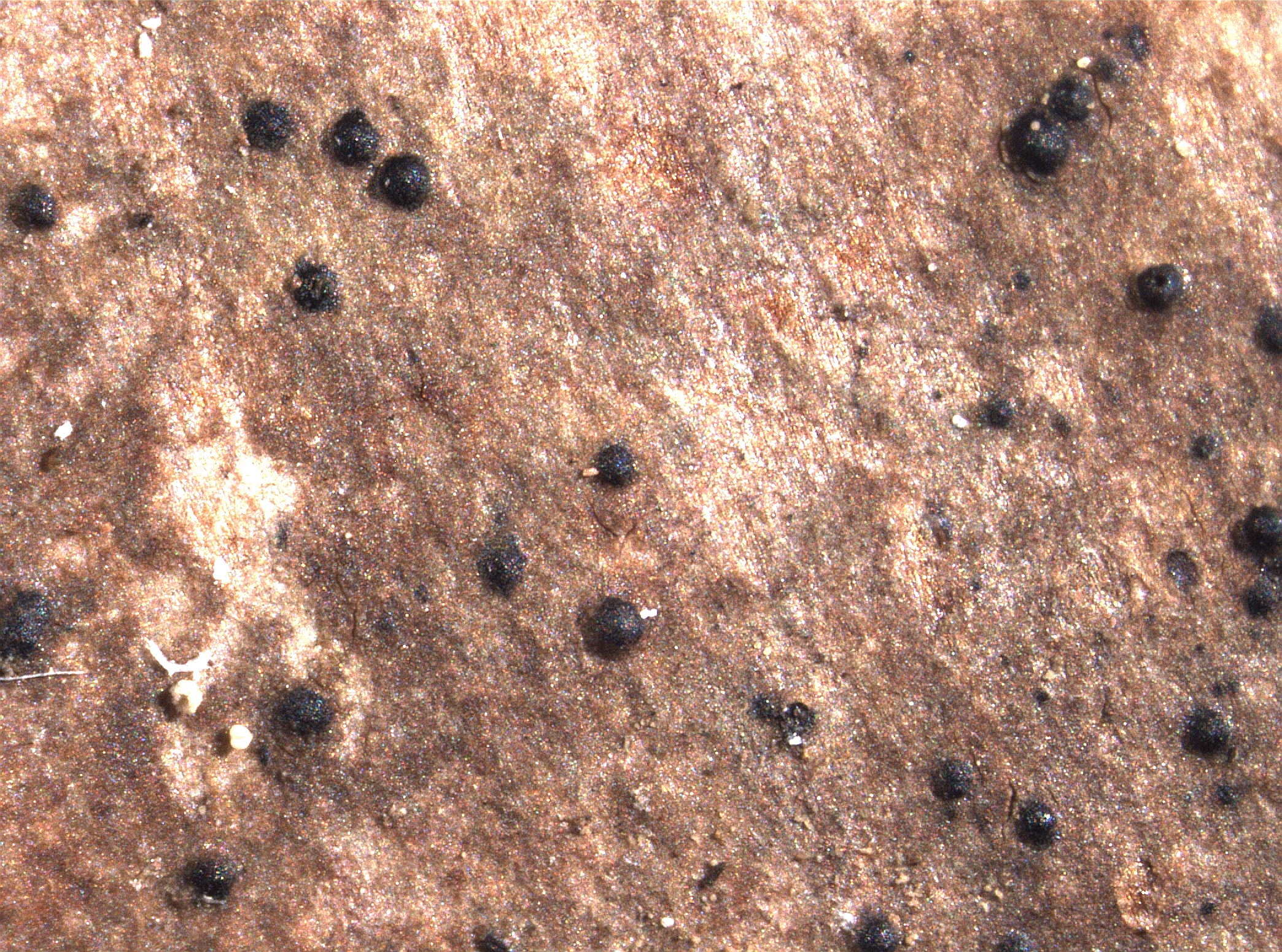
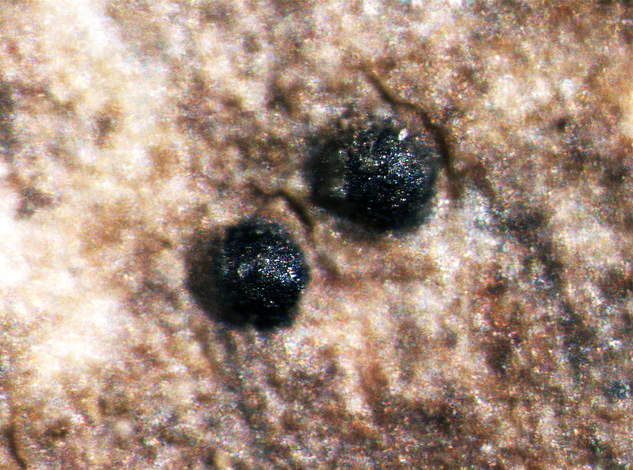
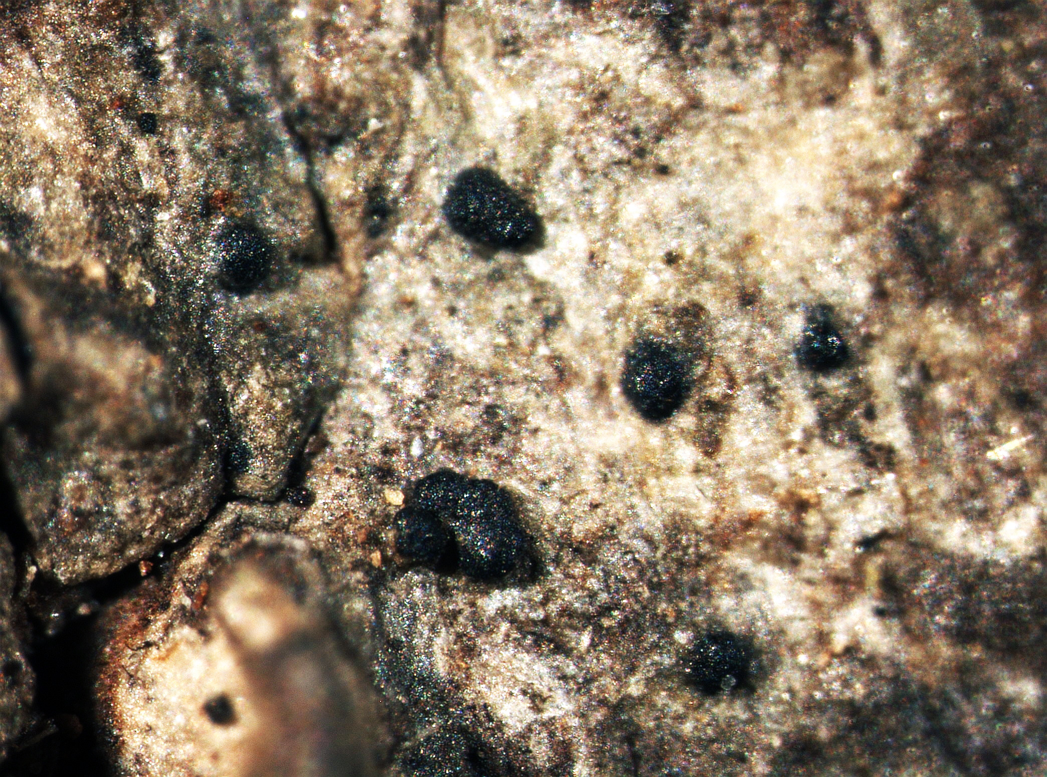
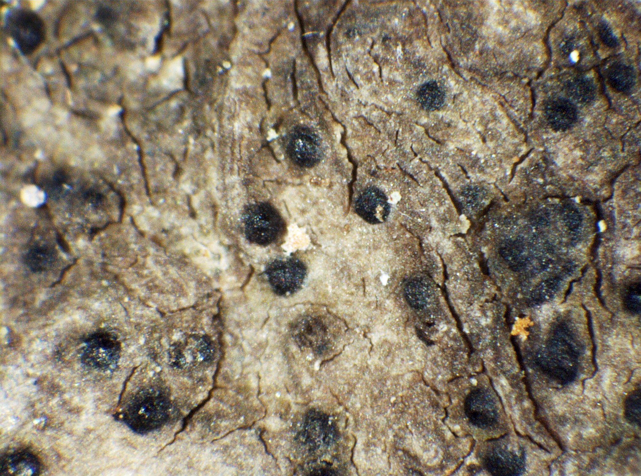
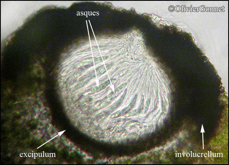
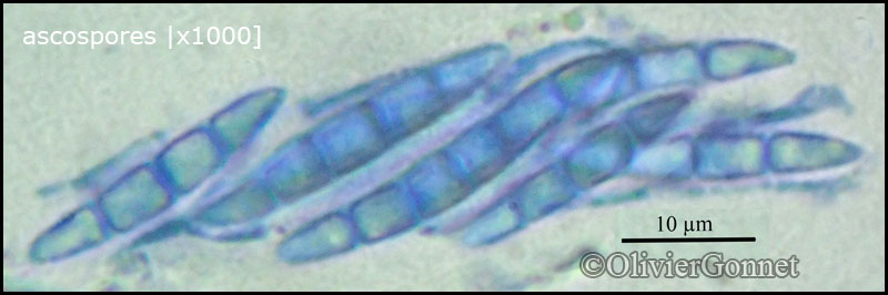
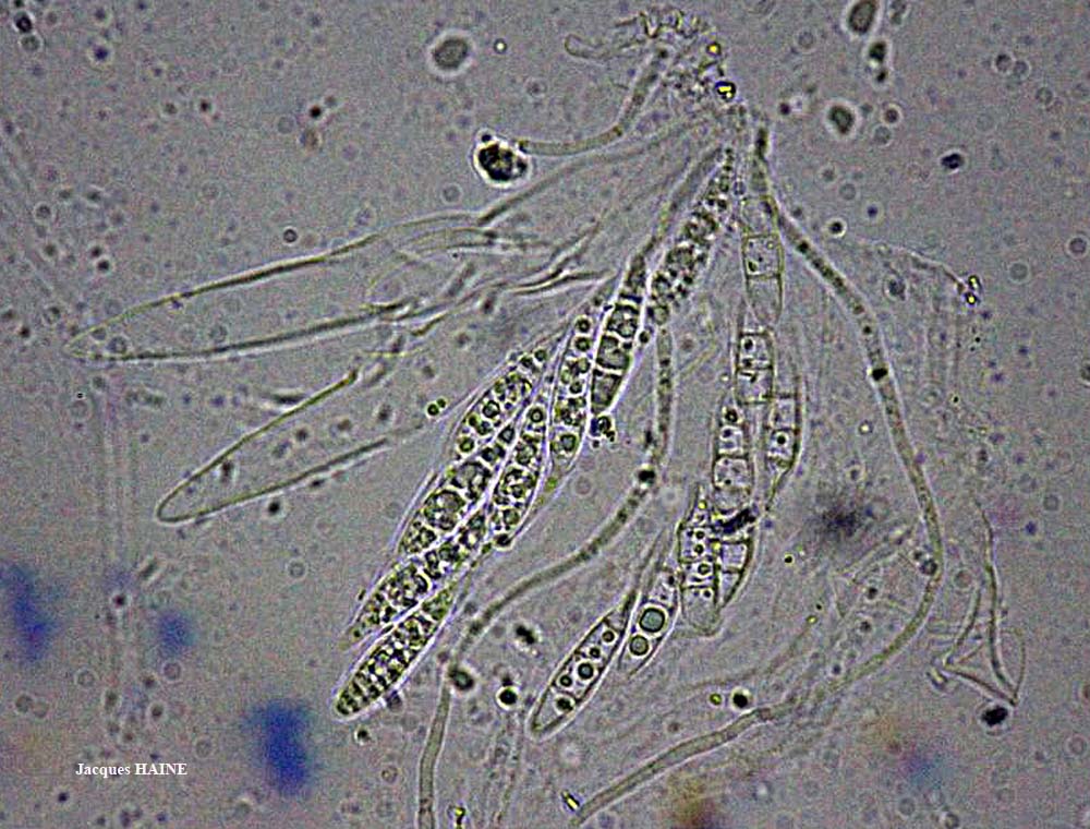
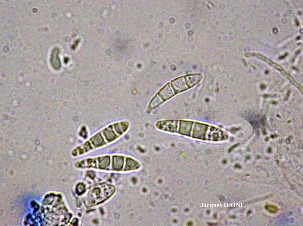
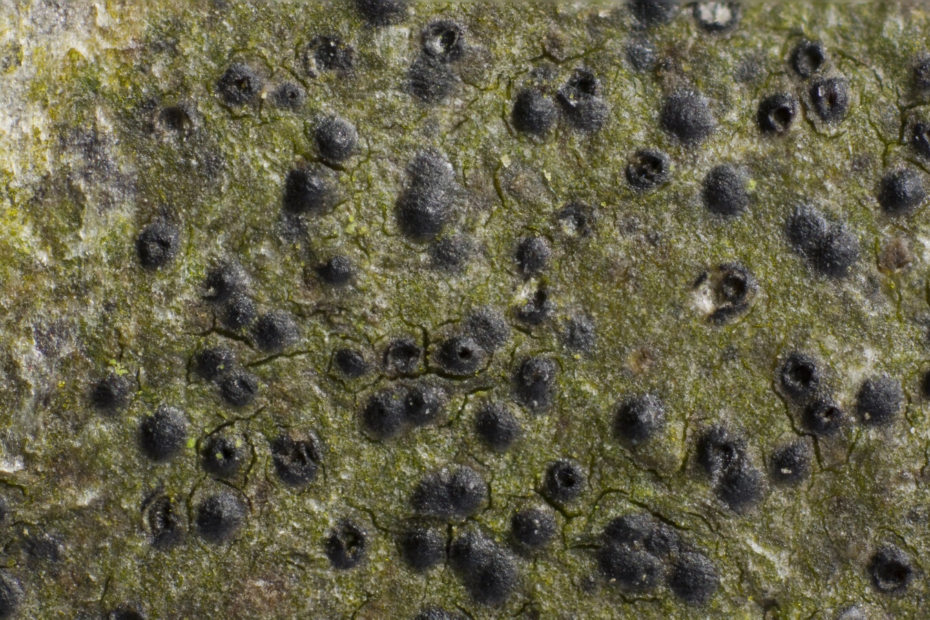
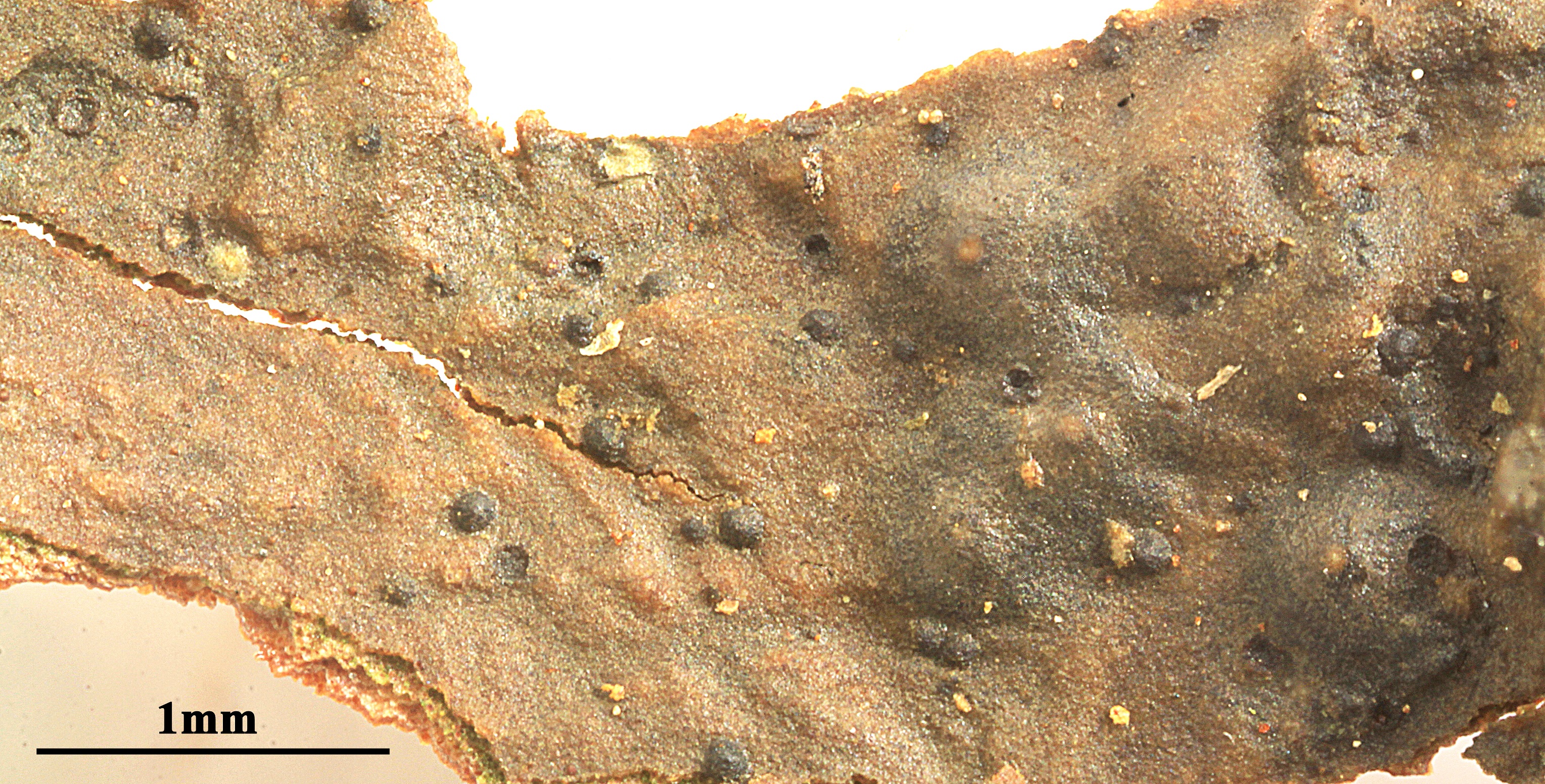
Description: Thallus crustose, thin, continuous, superficial to semi-immersed, dark greenish grey, dark red-brown to dark brown, sometimes almost black (olive-brown in shade), smooth to weakly rimose, forming small patches. Perithecia black, hemispherical, semi-immersed in the thallus, 0.1-0.3 mm across. Involucrellum dimidiate, shiny, purple-brown in upper part (Pseudosagedia-violet pigment), K+ dark grey-brown, HCl+ red-purple to red-brown, colourless in lower part; exciple more or less colourless (with brown inclusions), the upper part yellowish (Porina-yellow pigment), K+ orange; hamathecium of almost simple, not anastomosing, c. 0.5-1 µm thick paraphyses; hymenial gel I-, K/I-. Asci 8-spored, cylindrical-clavate, thin-walled throughout, functionally unitunicate, I-, K/I-, the apex truncate and containing a refractive ring which stains with Congo Red. Ascospores 3-septate, hyaline, fusiform, (13-)15-20(-24) x 3.5-5.5 µm. Pycnidia black, immersed. Macroconidia 1-septate, 12-16 x c. 4.5 µm; microconidia ellipsoid, c. 2 x 0.5 µm. Photobiont trentepohlioid. Spot tests: thallus K-, C-, KC-, P-, UV-. Chemistry: thallus without lichen substances.
Growth form: Crustose
Substrata: bark
Photobiont: Trentepohlia
Reproductive strategy: mainly sexual
Commonnes-rarity: (info)
Alpine belt: absent
Subalpine belt: absent
Montane belt: rare
Dry submediterranean belt: very rare
Humid submediterranean belt: rather rare
Padanian area: absent
pH of the substrata:
1 2 3 4 5

Solar irradiation:
1 2 3 4 5
Aridity:
1 2 3 4 5
Eutrophication:
1 2 3 4 5
Poleotolerance:
0 1 2 3
Altitudinal distribution:
1 2 3 4 5 6
Rarity
absent
extremely rare
very rare
rare
rather rare
rather common
common
very common
extremely common
Loading data...
Occurrence data
Predictive map

Leif Stridvall - Source: http://www.stridvall.se/la/galleries.php
Felix Schumm - CC BY-SA 4.0
[13151], GERMANY, Baden-Württemberg, Kreis Göppingen, nördlich von Bad Ditzenbach, am Weg von Auendorf (48°36.907'N, 9°41.286'E, 663 m) zum Galgenberg (714 m), TK 7424. Leg. Schumm 06.04.2007, det. Schumm 07.04.2007.
Felix Schumm - CC BY-SA 4.0
[13151], GERMANY, Baden-Württemberg, Kreis Göppingen, nördlich von Bad Ditzenbach, am Weg von Auendorf (48°36.907'N, 9°41.286'E, 663 m) zum Galgenberg (714 m), TK 7424. Leg. Schumm 06.04.2007, det. Schumm 07.04.2007.
Felix Schumm - CC BY-SA 4.0
[13151], GERMANY, Baden-Württemberg, Kreis Göppingen, nördlich von Bad Ditzenbach, am Weg von Auendorf (48°36.907'N, 9°41.286'E, 663 m) zum Galgenberg (714 m), TK 7424. Leg. Schumm 06.04.2007, det. Schumm 07.04.2007.
Felix Schumm - CC BY-SA 4.0
[13151], GERMANY, Baden-Württemberg, Kreis Göppingen, nördlich von Bad Ditzenbach, am Weg von Auendorf (48°36.907'N, 9°41.286'E, 663 m) zum Galgenberg (714 m), TK 7424. Leg. Schumm 06.04.2007, det. Schumm 07.04.2007.
Felix Schumm - CC BY-SA 4.0
[13151], GERMANY, Baden-Württemberg, Kreis Göppingen, nördlich von Bad Ditzenbach, am Weg von Auendorf (48°36.907'N, 9°41.286'E, 663 m) zum Galgenberg (714 m), TK 7424. Leg. Schumm 06.04.2007, det. Schumm 07.04.2007.
Felix Schumm - CC BY-SA 4.0
[13151], GERMANY, Baden-Württemberg, Kreis Göppingen, nördlich von Bad Ditzenbach, am Weg von Auendorf (48°36.907'N, 9°41.286'E, 663 m) zum Galgenberg (714 m), TK 7424. Leg. Schumm 06.04.2007, det. Schumm 07.04.2007.
Felix Schumm - CC BY-SA 4.0
[13151], GERMANY, Baden-Württemberg, Kreis Göppingen, nördlich von Bad Ditzenbach, am Weg von Auendorf (48°36.907'N, 9°41.286'E, 663 m) zum Galgenberg (714 m), TK 7424. Leg. Schumm 06.04.2007, det. Schumm 07.04.2007.

Felix Schumm - CC BY-SA 4.0
[13151], GERMANY, Baden-Württemberg, Kreis Göppingen, nördlich von Bad Ditzenbach, am Weg von Auendorf (48°36.907'N, 9°41.286'E, 663 m) zum Galgenberg (714 m), TK 7424. Leg. Schumm 06.04.2007, det. Schumm 07.04.2007.

Felix Schumm - CC BY-SA 4.0
[13151], GERMANY, Baden-Württemberg, Kreis Göppingen, nördlich von Bad Ditzenbach, am Weg von Auendorf (48°36.907'N, 9°41.286'E, 663 m) zum Galgenberg (714 m), TK 7424. Leg. Schumm 06.04.2007, det. Schumm 07.04.2007.

Felix Schumm - CC BY-SA 4.0
[13151], GERMANY, Baden-Württemberg, Kreis Göppingen, nördlich von Bad Ditzenbach, am Weg von Auendorf (48°36.907'N, 9°41.286'E, 663 m) zum Galgenberg (714 m), TK 7424. Leg. Schumm 06.04.2007, det. Schumm 07.04.2007.
Felix Schumm - CC BY-SA 4.0
[13151], GERMANY, Baden-Württemberg, Kreis Göppingen, nördlich von Bad Ditzenbach, am Weg von Auendorf (48°36.907'N, 9°41.286'E, 663 m) zum Galgenberg (714 m), TK 7424. Leg. Schumm 06.04.2007, det. Schumm 07.04.2007.
Felix Schumm - CC BY-SA 4.0
[13151], GERMANY, Baden-Württemberg, Kreis Göppingen, nördlich von Bad Ditzenbach, am Weg von Auendorf (48°36.907'N, 9°41.286'E, 663 m) zum Galgenberg (714 m), TK 7424. Leg. Schumm 06.04.2007, det. Schumm 07.04.2007.
Felix Schumm - CC BY-SA 4.0
[13151], GERMANY, Baden-Württemberg, Kreis Göppingen, nördlich von Bad Ditzenbach, am Weg von Auendorf (48°36.907'N, 9°41.286'E, 663 m) zum Galgenberg (714 m), TK 7424. Leg. Schumm 06.04.2007, det. Schumm 07.04.2007.

Felix Schumm - CC BY-SA 4.0
[13151], GERMANY, Baden-Württemberg, Kreis Göppingen, nördlich von Bad Ditzenbach, am Weg von Auendorf (48°36.907'N, 9°41.286'E, 663 m) zum Galgenberg (714 m), TK 7424. Leg. Schumm 06.04.2007, det. Schumm 07.04.2007.

Felix Schumm - CC BY-SA 4.0
[13151], GERMANY, Baden-Württemberg, Kreis Göppingen, nördlich von Bad Ditzenbach, am Weg von Auendorf (48°36.907'N, 9°41.286'E, 663 m) zum Galgenberg (714 m), TK 7424. Leg. Schumm 06.04.2007, det. Schumm 07.04.2007.

Felix Schumm - CC BY-SA 4.0
[13151], GERMANY, Baden-Württemberg, Kreis Göppingen, nördlich von Bad Ditzenbach, am Weg von Auendorf (48°36.907'N, 9°41.286'E, 663 m) zum Galgenberg (714 m), TK 7424. Leg. Schumm 06.04.2007, det. Schumm 07.04.2007.
Felix Schumm - CC BY-SA 4.0
[13637], Germany, Baden-Württemberg, Kreis Schwäbisch Gmünd, im Beutenbachtal bei der Beutenmühle ca. 3 km südöstlich von Lorch, 48°46.454' N, 9°42.865' E, ca 330 m, an Laubbaum in Bachnähe, TK 7224. Leg Schumm 20.02.2008, det. Schumm 20.02.2008
Felix Schumm - CC BY-SA 4.0
[13637], Germany, Baden-Württemberg, Kreis Schwäbisch Gmünd, im Beutenbachtal bei der Beutenmühle ca. 3 km südöstlich von Lorch, 48°46.454' N, 9°42.865' E, ca 330 m, an Laubbaum in Bachnähe, TK 7224. Leg Schumm 20.02.2008, det. Schumm 20.02.2008
Felix Schumm - CC BY-SA 4.0
[13637], Germany, Baden-Württemberg, Kreis Schwäbisch Gmünd, im Beutenbachtal bei der Beutenmühle ca. 3 km südöstlich von Lorch, 48°46.454' N, 9°42.865' E, ca 330 m, an Laubbaum in Bachnähe, TK 7224. Leg Schumm 20.02.2008, det. Schumm 20.02.2008

Felix Schumm - CC BY-SA 4.0
[13637], Germany, Baden-Württemberg, Kreis Schwäbisch Gmünd, im Beutenbachtal bei der Beutenmühle ca. 3 km südöstlich von Lorch, 48°46.454' N, 9°42.865' E, ca 330 m, an Laubbaum in Bachnähe, TK 7224. Leg Schumm 20.02.2008, det. Schumm 20.02.2008
Felix Schumm - CC BY-SA 4.0
[13637], Germany, Baden-Württemberg, Kreis Schwäbisch Gmünd, im Beutenbachtal bei der Beutenmühle ca. 3 km südöstlich von Lorch, 48°46.454' N, 9°42.865' E, ca 330 m, an Laubbaum in Bachnähe, TK 7224. Leg Schumm 20.02.2008, det. Schumm 20.02.2008
Felix Schumm - CC BY-SA 4.0
[13637], Germany, Baden-Württemberg, Kreis Schwäbisch Gmünd, im Beutenbachtal bei der Beutenmühle ca. 3 km südöstlich von Lorch, 48°46.454' N, 9°42.865' E, ca 330 m, an Laubbaum in Bachnähe, TK 7224. Leg Schumm 20.02.2008, det. Schumm 20.02.2008
Felix Schumm - CC BY-SA 4.0
[13637], Germany, Baden-Württemberg, Kreis Schwäbisch Gmünd, im Beutenbachtal bei der Beutenmühle ca. 3 km südöstlich von Lorch, 48°46.454' N, 9°42.865' E, ca 330 m, an Laubbaum in Bachnähe, TK 7224. Leg Schumm 20.02.2008, det. Schumm 20.02.2008

Felix Schumm - CC BY-SA 4.0
[13637], Germany, Baden-Württemberg, Kreis Schwäbisch Gmünd, im Beutenbachtal bei der Beutenmühle ca. 3 km südöstlich von Lorch, 48°46.454' N, 9°42.865' E, ca 330 m, an Laubbaum in Bachnähe, TK 7224. Leg Schumm 20.02.2008, det. Schumm 20.02.2008

Felix Schumm - CC BY-SA 4.0
[13637], Germany, Baden-Württemberg, Kreis Schwäbisch Gmünd, im Beutenbachtal bei der Beutenmühle ca. 3 km südöstlich von Lorch, 48°46.454' N, 9°42.865' E, ca 330 m, an Laubbaum in Bachnähe, TK 7224. Leg Schumm 20.02.2008, det. Schumm 20.02.2008
Felix Schumm - CC BY-SA 4.0
[13637], Germany, Baden-Württemberg, Kreis Schwäbisch Gmünd, im Beutenbachtal bei der Beutenmühle ca. 3 km südöstlich von Lorch, 48°46.454' N, 9°42.865' E, ca 330 m, an Laubbaum in Bachnähe, TK 7224. Leg Schumm 20.02.2008, det. Schumm 20.02.2008

Pier Luigi Nimis - CC BY-SA 4.0
TSB 41298
P.L. Nimis CC BY-SA 04
TSB 41298
P.L. Nimis CC BY-SA 04
TSB 42577
P.L. Nimis CC BY-SA 04
TSB 31910
P.L. Nimis CC BY-SA 04
TSB 37002
Felix Schumm – CC BY-SA 4.0
Image from: F. Schumm (2008) - Flechten Madeiras, der Kanaren und Azoren. Beck, OHG - ISBN: 978-3-00-023700-3

Courtesy Danièle et Olivier Gonnet - Source: https://www.afl-lichenologie.fr/Photos_AFL/Photos_AFL_P/Text_P_2/Porina_aenea.htm
France, avec coupe du périthèce - 2010 - sur écorce de bouleau - Fontainebleau
Courtesy Danièle et Olivier Gonnet - Source: https://www.afl-lichenologie.fr/Photos_AFL/Photos_AFL_P/Text_P_2/Porina_aenea.htm
France, avec coupe du périthèce - 2010 - sur écorce de bouleau - Fontainebleau

Courtesy Danièle et Olivier Gonnet - Source: https://www.afl-lichenologie.fr/Photos_AFL/Photos_AFL_P/Text_P_2/Porina_aenea.htm
France, avec coupe du périthèce - 2010 - sur écorce de bouleau - Fontainebleau

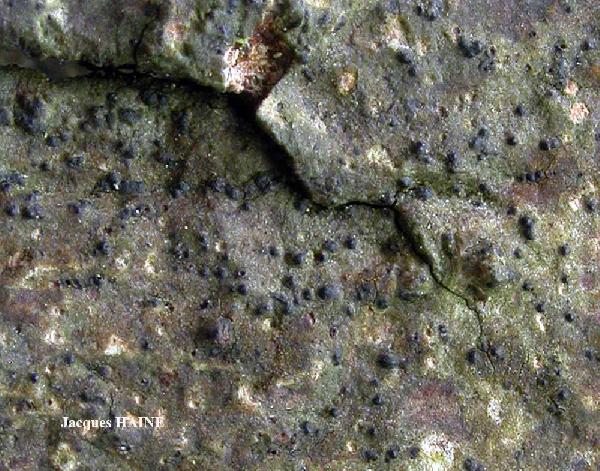
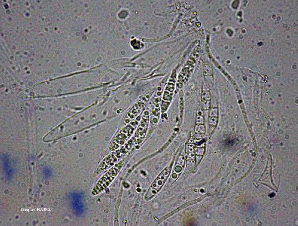
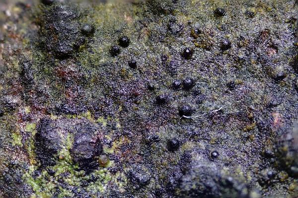
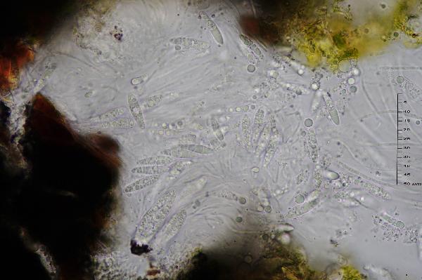
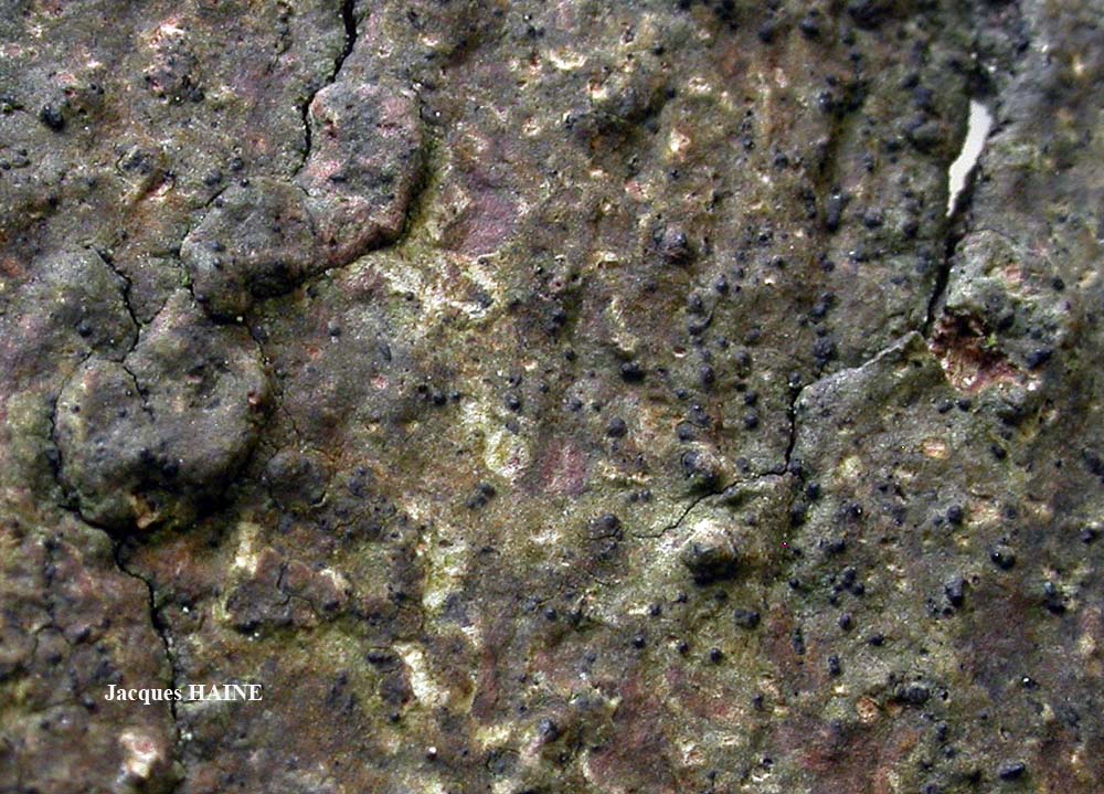
Jacques Haine - Source: http://www.lichensmaritimes.org/index.php?task=fiche&lichen=629&lang=en
France, Ardennes
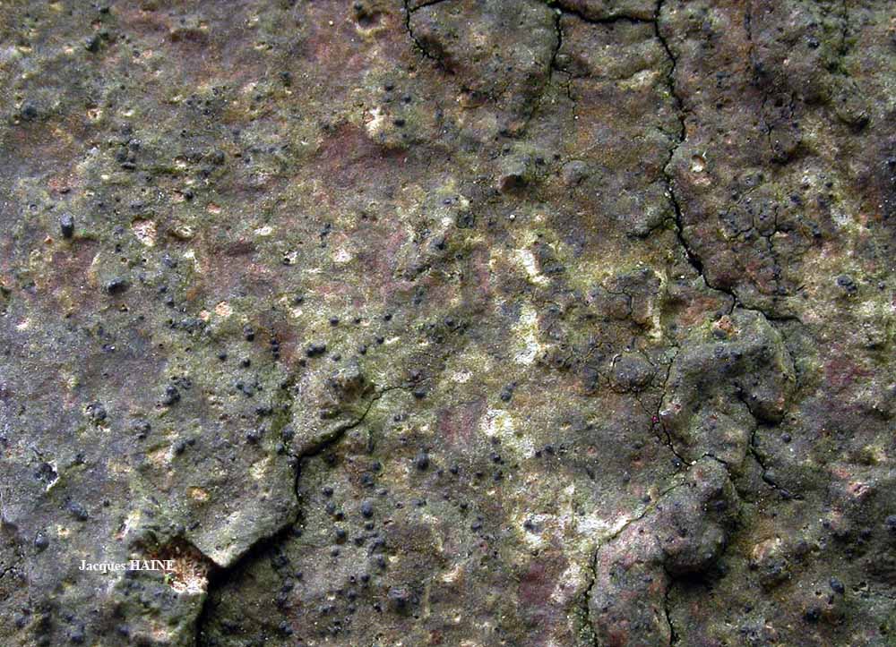
Jacques Haine - Source: http://www.lichensmaritimes.org/index.php?task=fiche&lichen=629&lang=en
France, Ardennes
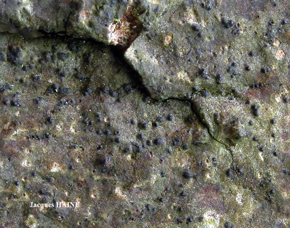
Jacques Haine - Source: http://www.lichensmaritimes.org/index.php?task=fiche&lichen=629&lang=en
France, Ardennes
Jacques Haine - Source: http://www.lichensmaritimes.org/index.php?task=fiche&lichen=629&lang=en
France, Ardennes

Jacques Haine - Source: http://www.lichensmaritimes.org/index.php?task=fiche&lichen=629&lang=en
France, Ardennes

Ulrich Kirschbaum CC BY-SA 4.0 - Source: https://www.thm.de/lse/ulrich-kirschbaum/flechtenbilder
Central Europe; Germany: Hesse. Collected by E. Heerd.
Marta Gonzalez Garcia - Centro de Estudios Micologicos Asturianos
Spain, Jardín Botánico Atlántico de Gijón (Asturias), sobre Laurus nobilis, 29-IV-2022.
Marta Gonzalez Garcia - Centro de Estudios Micologicos Asturianos
Spain, Jardín Botánico Atlántico de Gijón (Asturias), sobre Laurus nobilis, 29-IV-2022.
Enrique Rubio - Centro de Estudios Micologicos Asturianos
Spain, La Curtia (Castrillón-Asturias), 20-IV-2020, en raquis de Pteridium aquilinum, leg. E. Rubio, det. Paul Cannon, ERD-8332.
Enrique Rubio - Centro de Estudios Micologicos Asturianos
Spain, La Curtia (Castrillón-Asturias), 20-IV-2020, en raquis de Pteridium aquilinum, leg. E. Rubio, det. Paul Cannon, ERD-8332.
Enrique Rubio - Centro de Estudios Micologicos Asturianos
Spain, La Curtia (Castrillón-Asturias), 20-IV-2020, en raquis de Pteridium aquilinum, leg. E. Rubio, det. Paul Cannon, ERD-8332.
Enrique Rubio - Centro de Estudios Micologicos Asturianos
Spain, La Curtia (Castrillón-Asturias), 20-IV-2020, en raquis de Pteridium aquilinum, leg. E. Rubio, det. Paul Cannon, ERD-8332.
Felix Schumm - CC BY-SA 4.0
[ABL11584a], Brazil, Rondônia, Porto Velho, Parque Natural Municipal.
8°41'10'' S, 63°52''05' W, 100m. On tree bark in primary rain forest.
Leg. M. Cáceres & A. Aptroot, (no. 11584a), 9-12 March 1012, det. A.
Aptroot 2012.
Felix Schumm - CC BY-SA 4.0
[ABL11584a], Brazil, Rondônia, Porto Velho, Parque Natural Municipal.
8°41'10'' S, 63°52''05' W, 100m. On tree bark in primary rain forest.
Leg. M. Cáceres & A. Aptroot, (no. 11584a), 9-12 March 1012, det. A.
Aptroot 2012.
Marko Doboš
Levanjska Varoš, Croatia
Wolfgang von Brackel - CC BY-4.0
Germany, Bavaria, Schweinfurt
Wolfgang von Brackel - CC BY-4.0
Germany, Bavaria, Schweinfurt

Felix Schumm - CC BY-SA 4.0
[VZR68], Gallia. Pyrenei montes occidentales: in valle Gave d'Oloron
loco dicto Château de Laas, in horto publico, 70 m. Ad truncum
Bambusae (Pseudosassa japonica), Leg. J. Vivant, 4.9.1992, det. A.
Vezda. EX A. VEZDA: LICHENES RARIORES EXSICCATI NR. 68.

Felix Schumm - CC BY-SA 4.0
[VZR68], Gallia. Pyrenei montes occidentales: in valle Gave d'Oloron
loco dicto Château de Laas, in horto publico, 70 m. Ad truncum
Bambusae (Pseudosassa japonica), Leg. J. Vivant, 4.9.1992, det. A.
Vezda. EX A. VEZDA: LICHENES RARIORES EXSICCATI NR. 68.
Growth form: Crustose
Substrata: bark
Photobiont: Trentepohlia
Reproductive strategy: mainly sexual
Commonnes-rarity: (info)
Alpine belt: absent
Subalpine belt: absent
Montane belt: rare
Dry submediterranean belt: very rare
Humid submediterranean belt: rather rare
Padanian area: absent
pH of the substrata:
| 1 | 2 | 3 | 4 | 5 |
Solar irradiation:
| 1 | 2 | 3 | 4 | 5 |
Aridity:
| 1 | 2 | 3 | 4 | 5 |
Eutrophication:
| 1 | 2 | 3 | 4 | 5 |
Poleotolerance:
| 0 | 1 | 2 | 3 |
Altitudinal distribution:
| 1 | 2 | 3 | 4 | 5 | 6 |
Rarity
absent
extremely rare
very rare
rare
rather rare
rather common
common
very common
extremely common
Loading data...
Occurrence data
Predictive map
Leif Stridvall - Source: http://www.stridvall.se/la/galleries.php

Felix Schumm - CC BY-SA 4.0
[13151], GERMANY, Baden-Württemberg, Kreis Göppingen, nördlich von Bad Ditzenbach, am Weg von Auendorf (48°36.907'N, 9°41.286'E, 663 m) zum Galgenberg (714 m), TK 7424. Leg. Schumm 06.04.2007, det. Schumm 07.04.2007.

Felix Schumm - CC BY-SA 4.0
[13151], GERMANY, Baden-Württemberg, Kreis Göppingen, nördlich von Bad Ditzenbach, am Weg von Auendorf (48°36.907'N, 9°41.286'E, 663 m) zum Galgenberg (714 m), TK 7424. Leg. Schumm 06.04.2007, det. Schumm 07.04.2007.

Felix Schumm - CC BY-SA 4.0
[13151], GERMANY, Baden-Württemberg, Kreis Göppingen, nördlich von Bad Ditzenbach, am Weg von Auendorf (48°36.907'N, 9°41.286'E, 663 m) zum Galgenberg (714 m), TK 7424. Leg. Schumm 06.04.2007, det. Schumm 07.04.2007.
Felix Schumm - CC BY-SA 4.0
[13151], GERMANY, Baden-Württemberg, Kreis Göppingen, nördlich von Bad Ditzenbach, am Weg von Auendorf (48°36.907'N, 9°41.286'E, 663 m) zum Galgenberg (714 m), TK 7424. Leg. Schumm 06.04.2007, det. Schumm 07.04.2007.

Felix Schumm - CC BY-SA 4.0
[13151], GERMANY, Baden-Württemberg, Kreis Göppingen, nördlich von Bad Ditzenbach, am Weg von Auendorf (48°36.907'N, 9°41.286'E, 663 m) zum Galgenberg (714 m), TK 7424. Leg. Schumm 06.04.2007, det. Schumm 07.04.2007.
Felix Schumm - CC BY-SA 4.0
[13151], GERMANY, Baden-Württemberg, Kreis Göppingen, nördlich von Bad Ditzenbach, am Weg von Auendorf (48°36.907'N, 9°41.286'E, 663 m) zum Galgenberg (714 m), TK 7424. Leg. Schumm 06.04.2007, det. Schumm 07.04.2007.

Felix Schumm - CC BY-SA 4.0
[13151], GERMANY, Baden-Württemberg, Kreis Göppingen, nördlich von Bad Ditzenbach, am Weg von Auendorf (48°36.907'N, 9°41.286'E, 663 m) zum Galgenberg (714 m), TK 7424. Leg. Schumm 06.04.2007, det. Schumm 07.04.2007.
Felix Schumm - CC BY-SA 4.0
[13151], GERMANY, Baden-Württemberg, Kreis Göppingen, nördlich von Bad Ditzenbach, am Weg von Auendorf (48°36.907'N, 9°41.286'E, 663 m) zum Galgenberg (714 m), TK 7424. Leg. Schumm 06.04.2007, det. Schumm 07.04.2007.
Felix Schumm - CC BY-SA 4.0
[13151], GERMANY, Baden-Württemberg, Kreis Göppingen, nördlich von Bad Ditzenbach, am Weg von Auendorf (48°36.907'N, 9°41.286'E, 663 m) zum Galgenberg (714 m), TK 7424. Leg. Schumm 06.04.2007, det. Schumm 07.04.2007.
Felix Schumm - CC BY-SA 4.0
[13151], GERMANY, Baden-Württemberg, Kreis Göppingen, nördlich von Bad Ditzenbach, am Weg von Auendorf (48°36.907'N, 9°41.286'E, 663 m) zum Galgenberg (714 m), TK 7424. Leg. Schumm 06.04.2007, det. Schumm 07.04.2007.
Felix Schumm - CC BY-SA 4.0
[13151], GERMANY, Baden-Württemberg, Kreis Göppingen, nördlich von Bad Ditzenbach, am Weg von Auendorf (48°36.907'N, 9°41.286'E, 663 m) zum Galgenberg (714 m), TK 7424. Leg. Schumm 06.04.2007, det. Schumm 07.04.2007.

Felix Schumm - CC BY-SA 4.0
[13151], GERMANY, Baden-Württemberg, Kreis Göppingen, nördlich von Bad Ditzenbach, am Weg von Auendorf (48°36.907'N, 9°41.286'E, 663 m) zum Galgenberg (714 m), TK 7424. Leg. Schumm 06.04.2007, det. Schumm 07.04.2007.
Felix Schumm - CC BY-SA 4.0
[13151], GERMANY, Baden-Württemberg, Kreis Göppingen, nördlich von Bad Ditzenbach, am Weg von Auendorf (48°36.907'N, 9°41.286'E, 663 m) zum Galgenberg (714 m), TK 7424. Leg. Schumm 06.04.2007, det. Schumm 07.04.2007.
Felix Schumm - CC BY-SA 4.0
[13151], GERMANY, Baden-Württemberg, Kreis Göppingen, nördlich von Bad Ditzenbach, am Weg von Auendorf (48°36.907'N, 9°41.286'E, 663 m) zum Galgenberg (714 m), TK 7424. Leg. Schumm 06.04.2007, det. Schumm 07.04.2007.
Felix Schumm - CC BY-SA 4.0
[13151], GERMANY, Baden-Württemberg, Kreis Göppingen, nördlich von Bad Ditzenbach, am Weg von Auendorf (48°36.907'N, 9°41.286'E, 663 m) zum Galgenberg (714 m), TK 7424. Leg. Schumm 06.04.2007, det. Schumm 07.04.2007.
Felix Schumm - CC BY-SA 4.0
[13151], GERMANY, Baden-Württemberg, Kreis Göppingen, nördlich von Bad Ditzenbach, am Weg von Auendorf (48°36.907'N, 9°41.286'E, 663 m) zum Galgenberg (714 m), TK 7424. Leg. Schumm 06.04.2007, det. Schumm 07.04.2007.

Felix Schumm - CC BY-SA 4.0
[13637], Germany, Baden-Württemberg, Kreis Schwäbisch Gmünd, im Beutenbachtal bei der Beutenmühle ca. 3 km südöstlich von Lorch, 48°46.454' N, 9°42.865' E, ca 330 m, an Laubbaum in Bachnähe, TK 7224. Leg Schumm 20.02.2008, det. Schumm 20.02.2008
Felix Schumm - CC BY-SA 4.0
[13637], Germany, Baden-Württemberg, Kreis Schwäbisch Gmünd, im Beutenbachtal bei der Beutenmühle ca. 3 km südöstlich von Lorch, 48°46.454' N, 9°42.865' E, ca 330 m, an Laubbaum in Bachnähe, TK 7224. Leg Schumm 20.02.2008, det. Schumm 20.02.2008

Felix Schumm - CC BY-SA 4.0
[13637], Germany, Baden-Württemberg, Kreis Schwäbisch Gmünd, im Beutenbachtal bei der Beutenmühle ca. 3 km südöstlich von Lorch, 48°46.454' N, 9°42.865' E, ca 330 m, an Laubbaum in Bachnähe, TK 7224. Leg Schumm 20.02.2008, det. Schumm 20.02.2008
Felix Schumm - CC BY-SA 4.0
[13637], Germany, Baden-Württemberg, Kreis Schwäbisch Gmünd, im Beutenbachtal bei der Beutenmühle ca. 3 km südöstlich von Lorch, 48°46.454' N, 9°42.865' E, ca 330 m, an Laubbaum in Bachnähe, TK 7224. Leg Schumm 20.02.2008, det. Schumm 20.02.2008
Felix Schumm - CC BY-SA 4.0
[13637], Germany, Baden-Württemberg, Kreis Schwäbisch Gmünd, im Beutenbachtal bei der Beutenmühle ca. 3 km südöstlich von Lorch, 48°46.454' N, 9°42.865' E, ca 330 m, an Laubbaum in Bachnähe, TK 7224. Leg Schumm 20.02.2008, det. Schumm 20.02.2008

Felix Schumm - CC BY-SA 4.0
[13637], Germany, Baden-Württemberg, Kreis Schwäbisch Gmünd, im Beutenbachtal bei der Beutenmühle ca. 3 km südöstlich von Lorch, 48°46.454' N, 9°42.865' E, ca 330 m, an Laubbaum in Bachnähe, TK 7224. Leg Schumm 20.02.2008, det. Schumm 20.02.2008
Felix Schumm - CC BY-SA 4.0
[13637], Germany, Baden-Württemberg, Kreis Schwäbisch Gmünd, im Beutenbachtal bei der Beutenmühle ca. 3 km südöstlich von Lorch, 48°46.454' N, 9°42.865' E, ca 330 m, an Laubbaum in Bachnähe, TK 7224. Leg Schumm 20.02.2008, det. Schumm 20.02.2008
Felix Schumm - CC BY-SA 4.0
[13637], Germany, Baden-Württemberg, Kreis Schwäbisch Gmünd, im Beutenbachtal bei der Beutenmühle ca. 3 km südöstlich von Lorch, 48°46.454' N, 9°42.865' E, ca 330 m, an Laubbaum in Bachnähe, TK 7224. Leg Schumm 20.02.2008, det. Schumm 20.02.2008
Felix Schumm - CC BY-SA 4.0
[13637], Germany, Baden-Württemberg, Kreis Schwäbisch Gmünd, im Beutenbachtal bei der Beutenmühle ca. 3 km südöstlich von Lorch, 48°46.454' N, 9°42.865' E, ca 330 m, an Laubbaum in Bachnähe, TK 7224. Leg Schumm 20.02.2008, det. Schumm 20.02.2008

Felix Schumm - CC BY-SA 4.0
[13637], Germany, Baden-Württemberg, Kreis Schwäbisch Gmünd, im Beutenbachtal bei der Beutenmühle ca. 3 km südöstlich von Lorch, 48°46.454' N, 9°42.865' E, ca 330 m, an Laubbaum in Bachnähe, TK 7224. Leg Schumm 20.02.2008, det. Schumm 20.02.2008
Pier Luigi Nimis - CC BY-SA 4.0
TSB 41298
P.L. Nimis CC BY-SA 04
TSB 41298
P.L. Nimis CC BY-SA 04
TSB 42577

P.L. Nimis CC BY-SA 04
TSB 31910
P.L. Nimis CC BY-SA 04
TSB 37002

Felix Schumm – CC BY-SA 4.0
Image from: F. Schumm (2008) - Flechten Madeiras, der Kanaren und Azoren. Beck, OHG - ISBN: 978-3-00-023700-3
Courtesy Danièle et Olivier Gonnet - Source: https://www.afl-lichenologie.fr/Photos_AFL/Photos_AFL_P/Text_P_2/Porina_aenea.htm
France, avec coupe du périthèce - 2010 - sur écorce de bouleau - Fontainebleau

Courtesy Danièle et Olivier Gonnet - Source: https://www.afl-lichenologie.fr/Photos_AFL/Photos_AFL_P/Text_P_2/Porina_aenea.htm
France, avec coupe du périthèce - 2010 - sur écorce de bouleau - Fontainebleau
Courtesy Danièle et Olivier Gonnet - Source: https://www.afl-lichenologie.fr/Photos_AFL/Photos_AFL_P/Text_P_2/Porina_aenea.htm
France, avec coupe du périthèce - 2010 - sur écorce de bouleau - Fontainebleau
Jacques Haine - Source: http://www.lichensmaritimes.org/index.php?task=fiche&lichen=629&lang=en
France, Ardennes
Jacques Haine - Source: http://www.lichensmaritimes.org/index.php?task=fiche&lichen=629&lang=en
France, Ardennes
Jacques Haine - Source: http://www.lichensmaritimes.org/index.php?task=fiche&lichen=629&lang=en
France, Ardennes
Jacques Haine - Source: http://www.lichensmaritimes.org/index.php?task=fiche&lichen=629&lang=en
France, Ardennes
Jacques Haine - Source: http://www.lichensmaritimes.org/index.php?task=fiche&lichen=629&lang=en
France, Ardennes
Ulrich Kirschbaum CC BY-SA 4.0 - Source: https://www.thm.de/lse/ulrich-kirschbaum/flechtenbilder
Central Europe; Germany: Hesse. Collected by E. Heerd.

Marta Gonzalez Garcia - Centro de Estudios Micologicos Asturianos
Spain, Jardín Botánico Atlántico de Gijón (Asturias), sobre Laurus nobilis, 29-IV-2022.

Marta Gonzalez Garcia - Centro de Estudios Micologicos Asturianos
Spain, Jardín Botánico Atlántico de Gijón (Asturias), sobre Laurus nobilis, 29-IV-2022.

Enrique Rubio - Centro de Estudios Micologicos Asturianos
Spain, La Curtia (Castrillón-Asturias), 20-IV-2020, en raquis de Pteridium aquilinum, leg. E. Rubio, det. Paul Cannon, ERD-8332.

Enrique Rubio - Centro de Estudios Micologicos Asturianos
Spain, La Curtia (Castrillón-Asturias), 20-IV-2020, en raquis de Pteridium aquilinum, leg. E. Rubio, det. Paul Cannon, ERD-8332.

Enrique Rubio - Centro de Estudios Micologicos Asturianos
Spain, La Curtia (Castrillón-Asturias), 20-IV-2020, en raquis de Pteridium aquilinum, leg. E. Rubio, det. Paul Cannon, ERD-8332.

Enrique Rubio - Centro de Estudios Micologicos Asturianos
Spain, La Curtia (Castrillón-Asturias), 20-IV-2020, en raquis de Pteridium aquilinum, leg. E. Rubio, det. Paul Cannon, ERD-8332.
Felix Schumm - CC BY-SA 4.0
[ABL11584a], Brazil, Rondônia, Porto Velho, Parque Natural Municipal. 8°41'10'' S, 63°52''05' W, 100m. On tree bark in primary rain forest. Leg. M. Cáceres & A. Aptroot, (no. 11584a), 9-12 March 1012, det. A. Aptroot 2012.

Felix Schumm - CC BY-SA 4.0
[ABL11584a], Brazil, Rondônia, Porto Velho, Parque Natural Municipal. 8°41'10'' S, 63°52''05' W, 100m. On tree bark in primary rain forest. Leg. M. Cáceres & A. Aptroot, (no. 11584a), 9-12 March 1012, det. A. Aptroot 2012.

Marko Doboš
Levanjska Varoš, Croatia

Wolfgang von Brackel - CC BY-4.0
Germany, Bavaria, Schweinfurt

Wolfgang von Brackel - CC BY-4.0
Germany, Bavaria, Schweinfurt

Felix Schumm - CC BY-SA 4.0
[VZR68], Gallia. Pyrenei montes occidentales: in valle Gave d'Oloron loco dicto Château de Laas, in horto publico, 70 m. Ad truncum Bambusae (Pseudosassa japonica), Leg. J. Vivant, 4.9.1992, det. A. Vezda. EX A. VEZDA: LICHENES RARIORES EXSICCATI NR. 68.


