
Pyrenodesmia variabilis (Pers.) A. Massal.
Atti reale Ist. Veneto Sci. ser. 2., 3 append.: 125, 1853. Basionym: Lichen variabilis Pers. - Ann. Bot. (Usteri), 1: 26, 1794.
Synonyms: Blastenia rhinodinoides (J. Steiner) Szatala; Callopisma variabile (Pers.) Trevis.; Caloplaca alpestris sensu Ozenda & Clauzade; Caloplaca fulva (Anzi) J. Steiner; Caloplaca intercedens (Trevis.) J. Steiner; Caloplaca paepalostoma (Anzi) Jatta; Caloplaca rhinodinoides J. Steiner; Caloplaca variabilis (Pers.) Th. Fr.; Caloplaca variabilis f. fulva (Anzi) Clauzade & Cl. Roux; Caloplaca variabilis f. fusca (A. Massal.) Jatta; Caloplaca variabilis f. paepalostoma (Anzi) Clauzade & Cl. Roux; Caloplaca variabilis var. granulosa (Arnold) Dalla Torre & Sarnth.; Caloplaca variabilis var. ochracea Müll. Arg.; Caloplaca variabilis var. subimmersa (Nyl.) Blomb. & Forssell; Lecanora variabilis (Pers.) Ach.; Placodium fulvum Anzi; Placodium paepalostomum Anzi; Placodium variabile (Pers.) Hepp; Pyrenodesmia intercedens Trevis.; Pyrenodesmia variabilis f. fusca A. Massal.; Rinodina articulata Bagl.
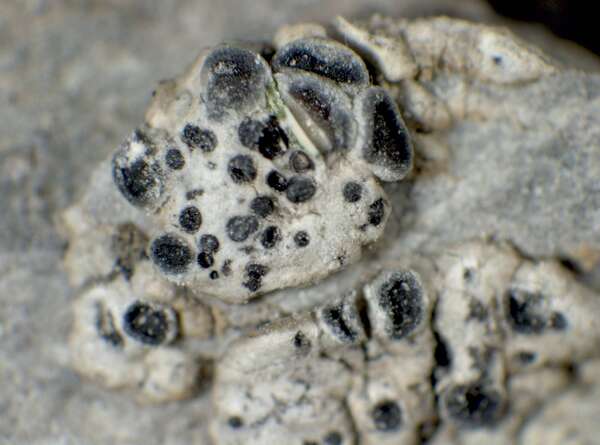
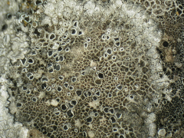
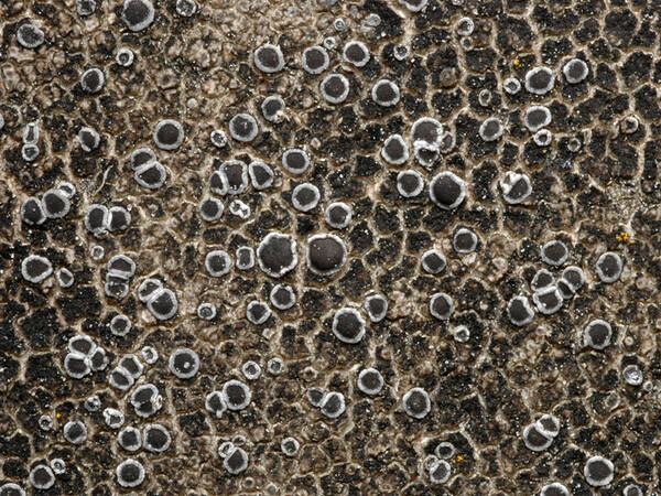
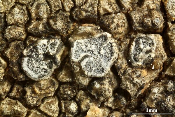
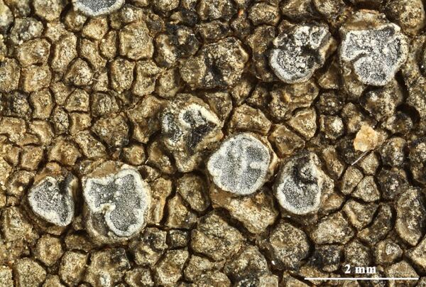
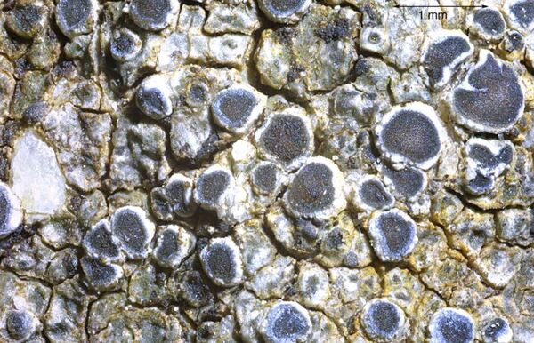
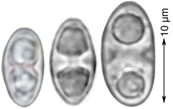
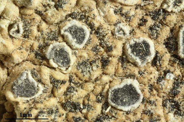
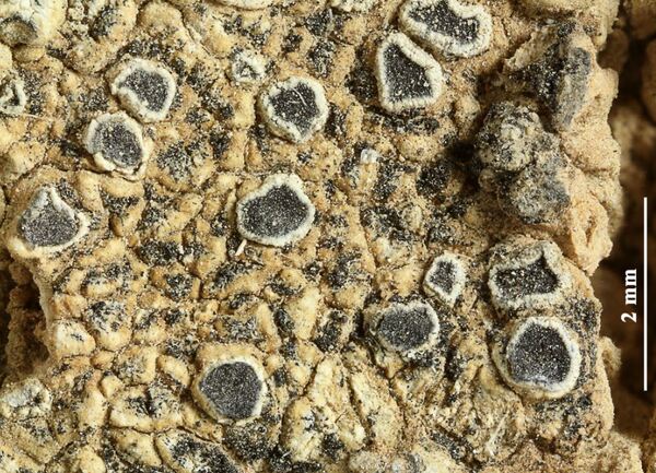
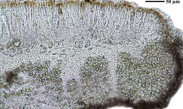
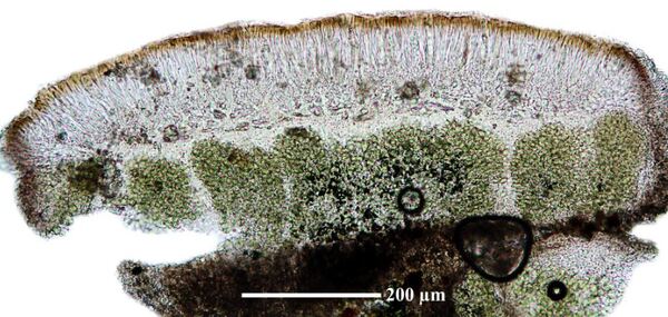
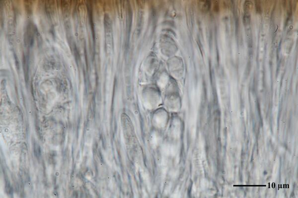
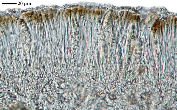
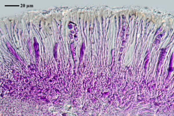
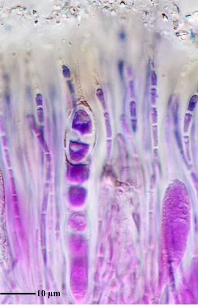
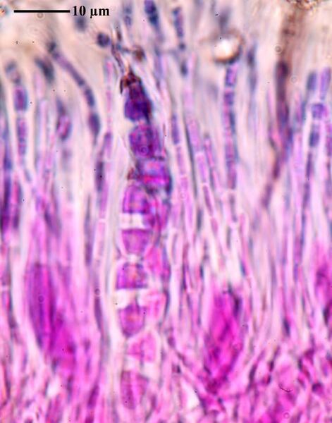
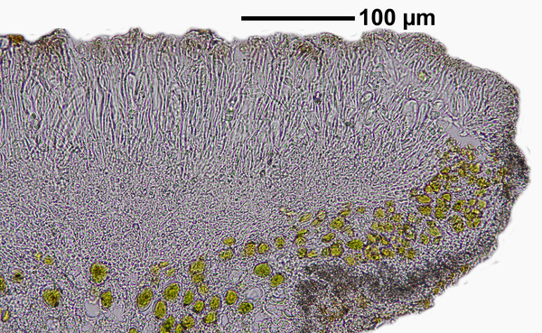
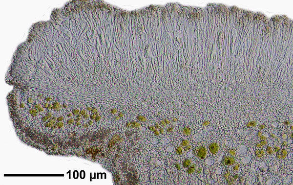
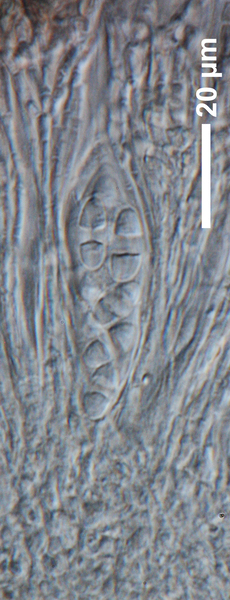
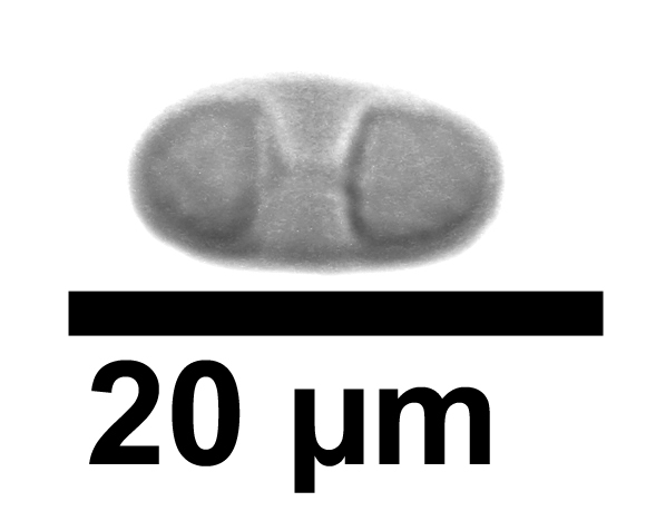
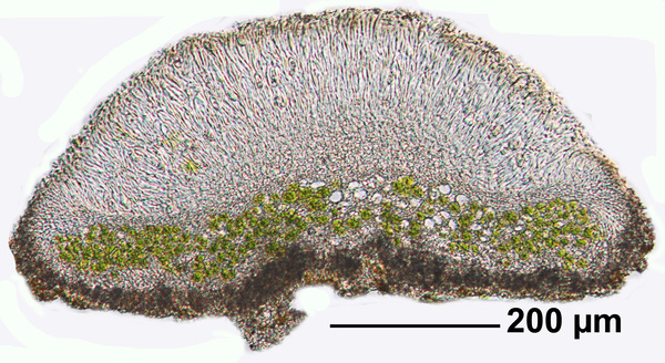
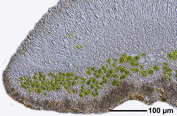
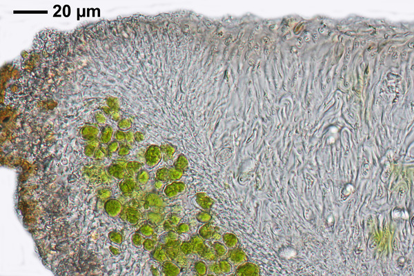
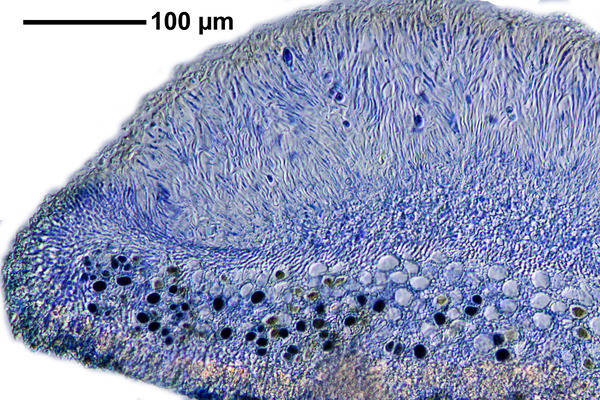
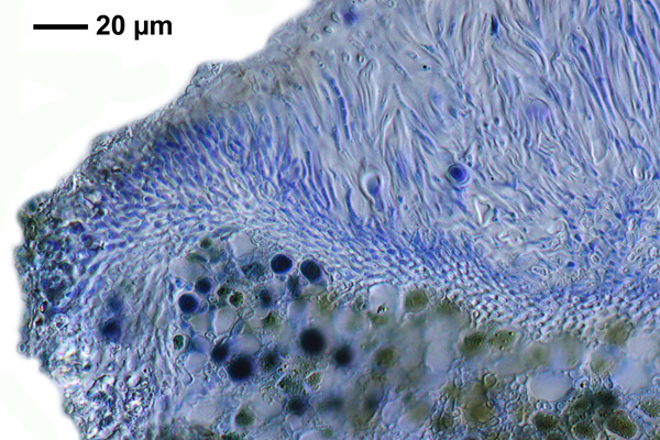
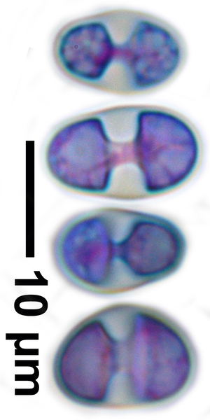
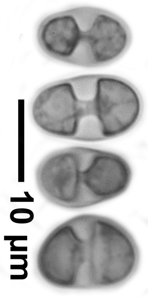
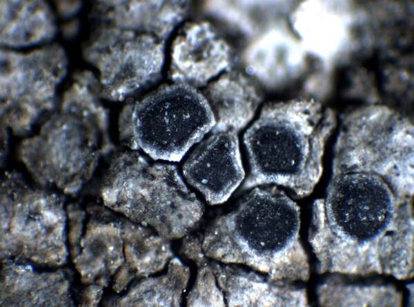
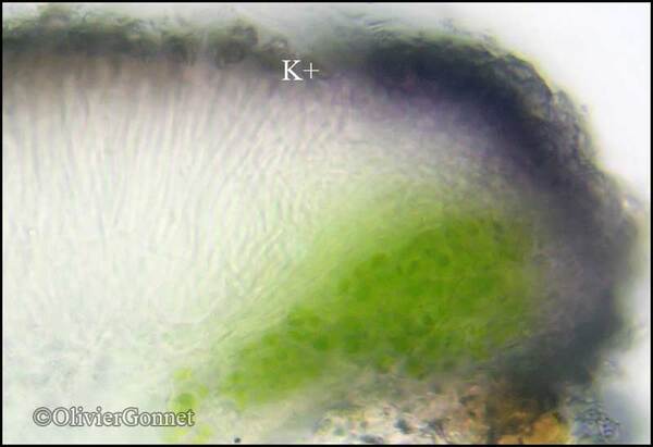
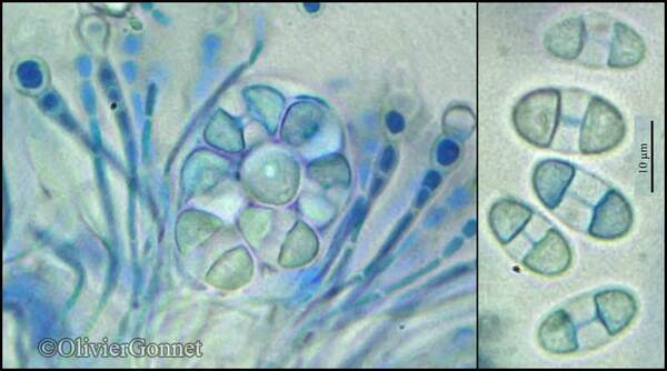
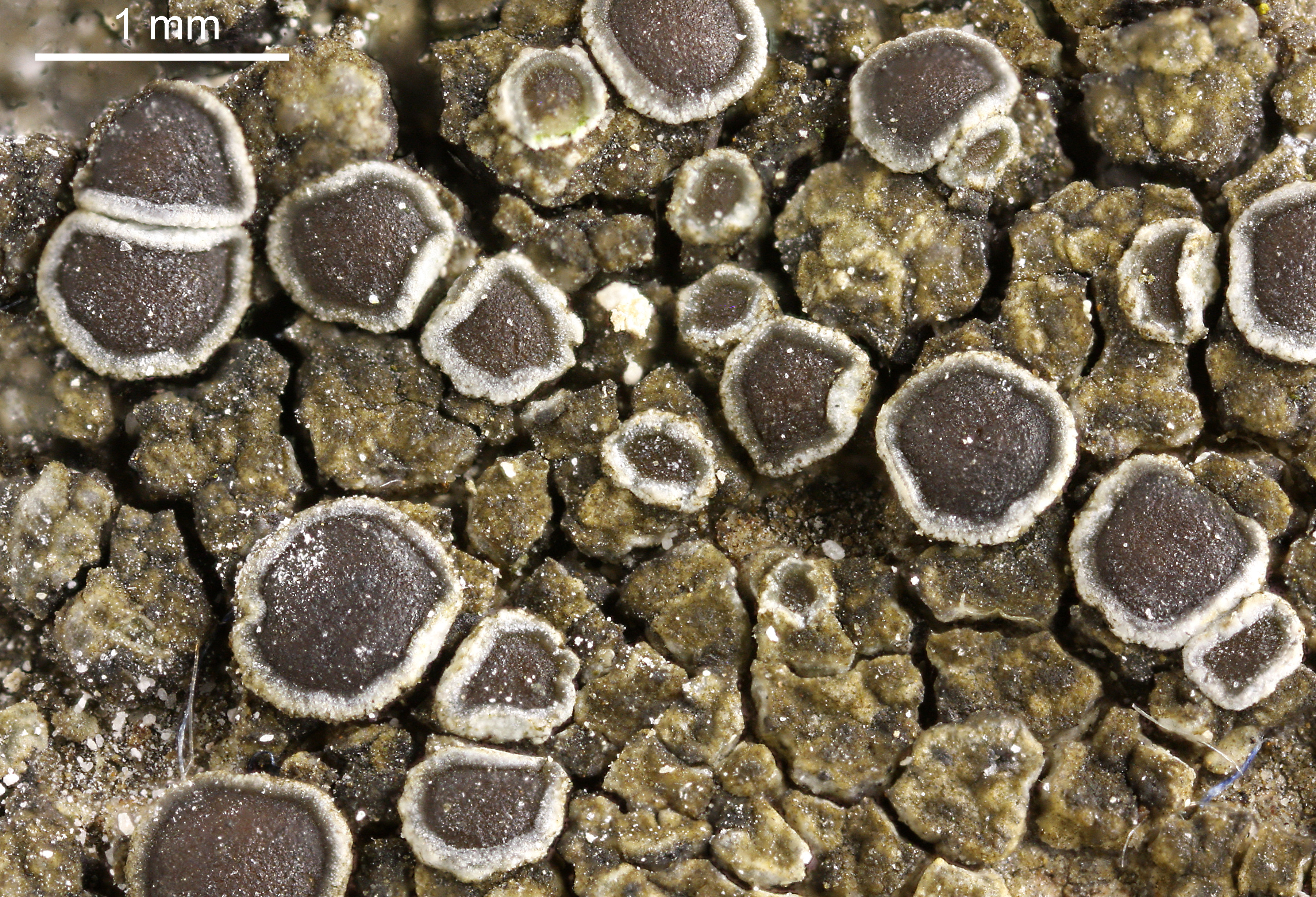
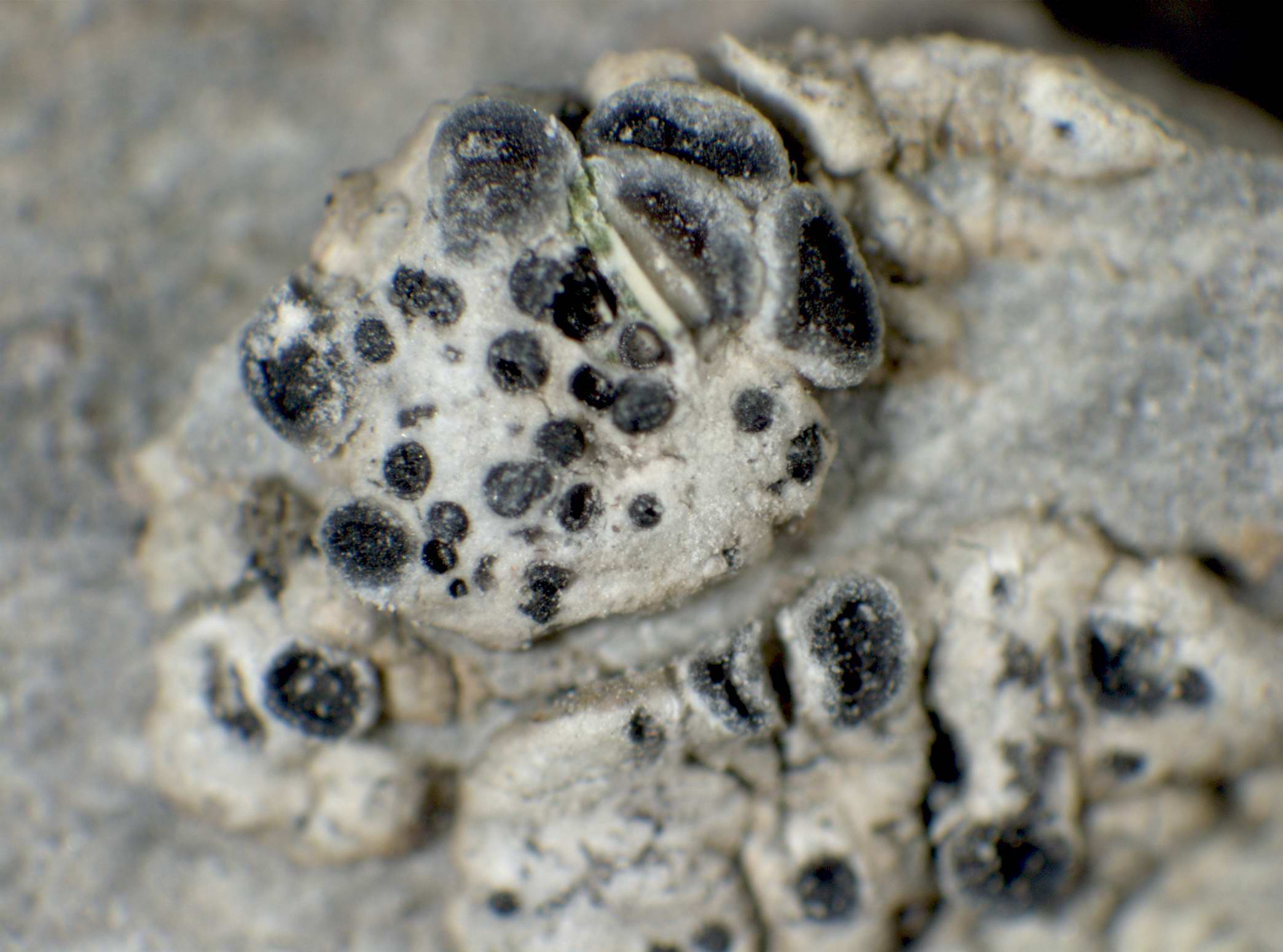
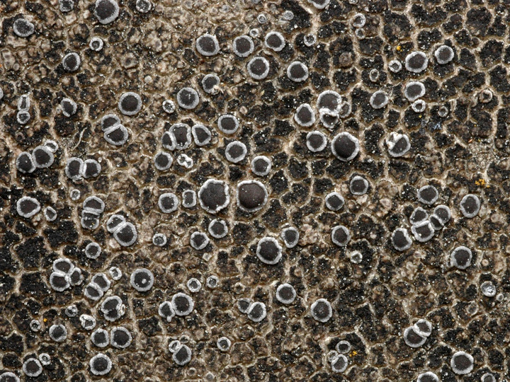
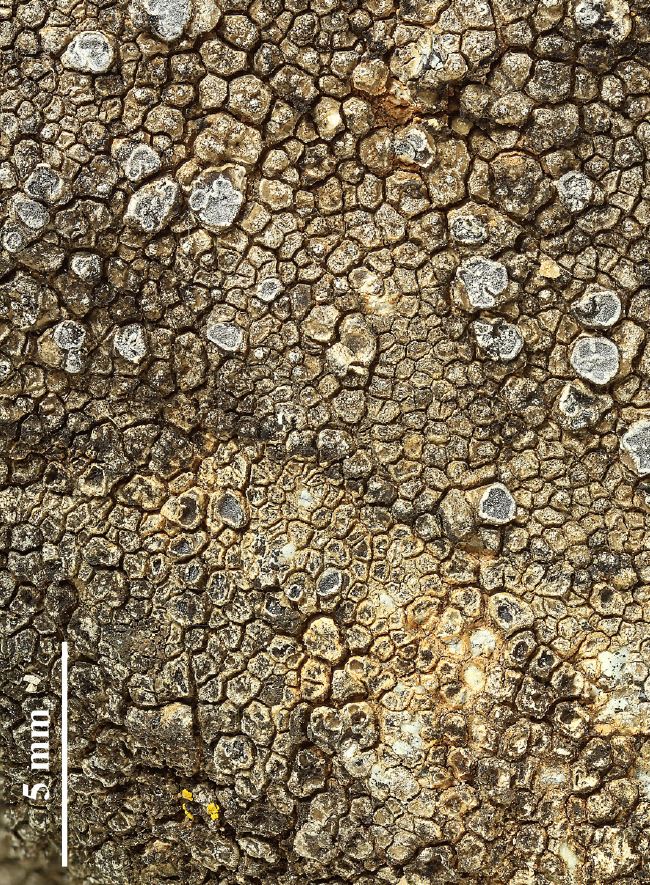
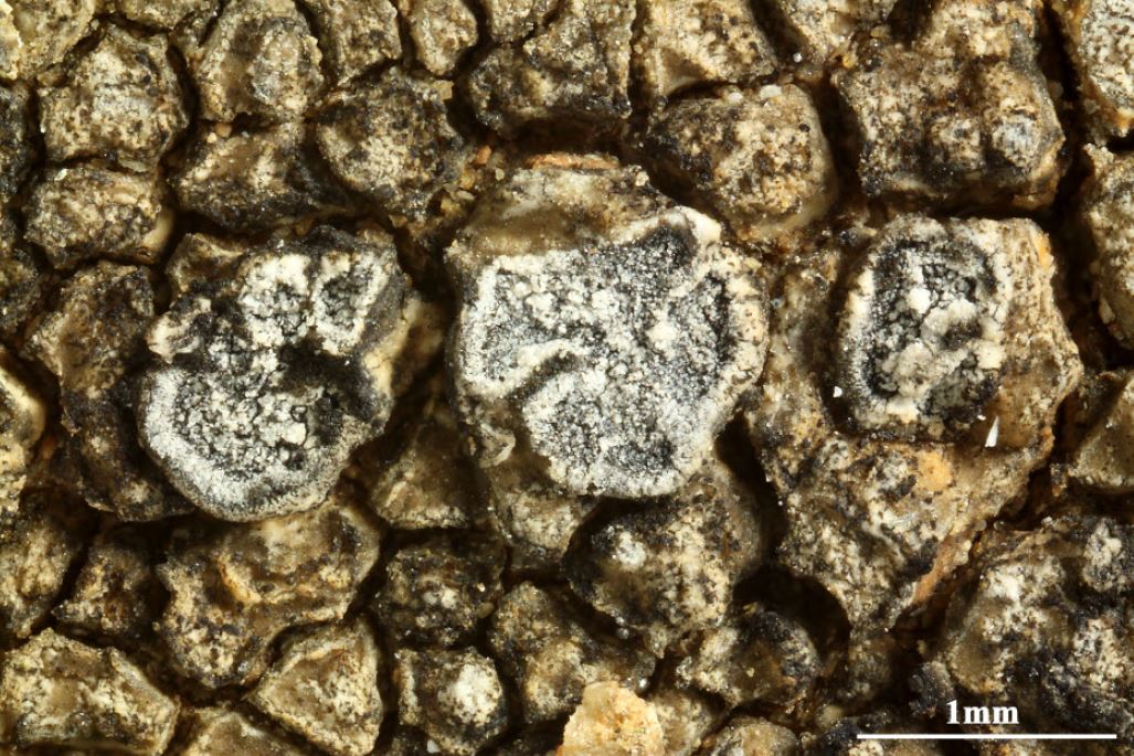
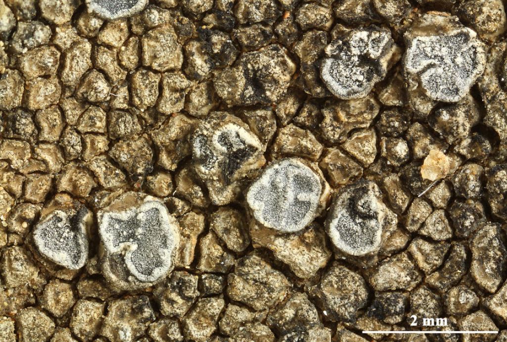
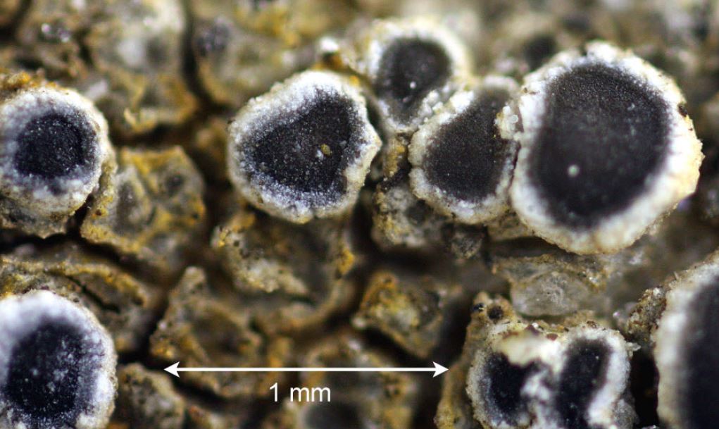
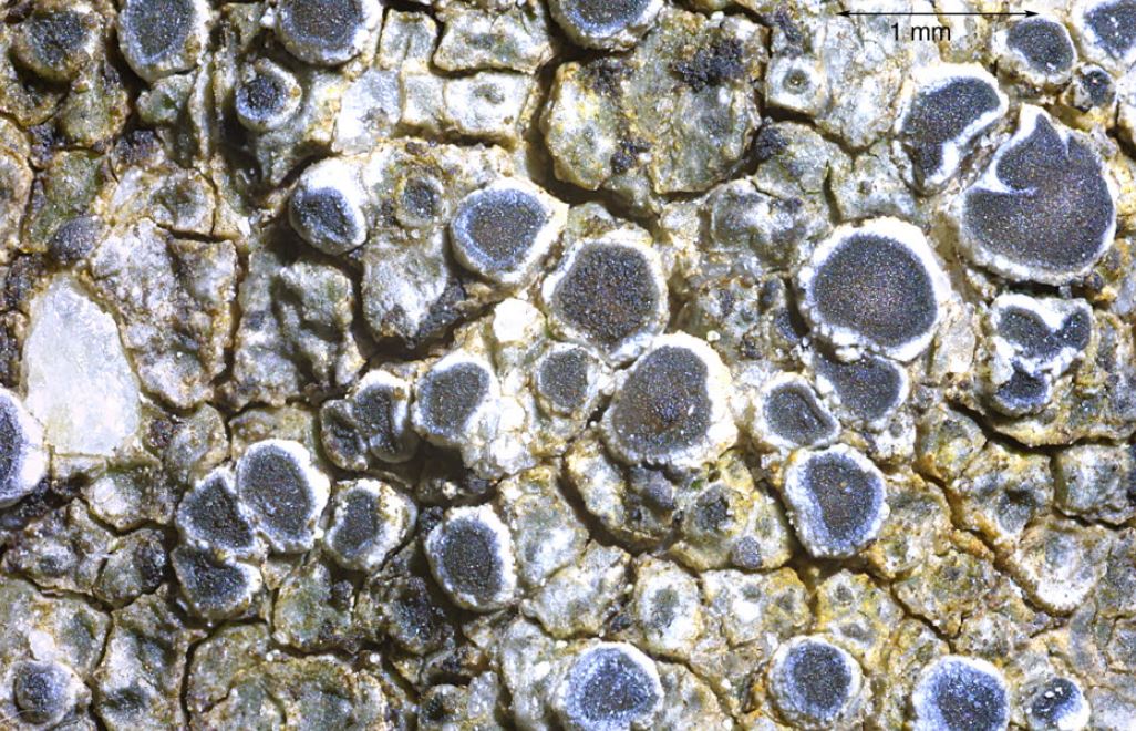
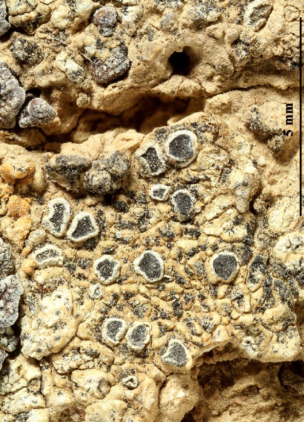
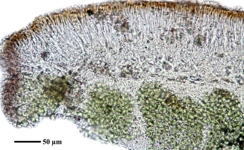
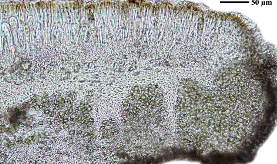
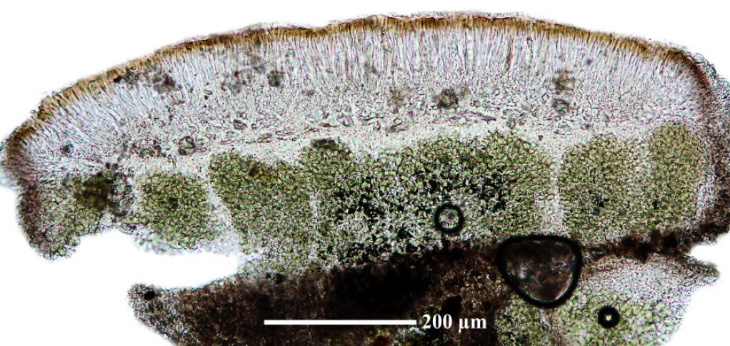
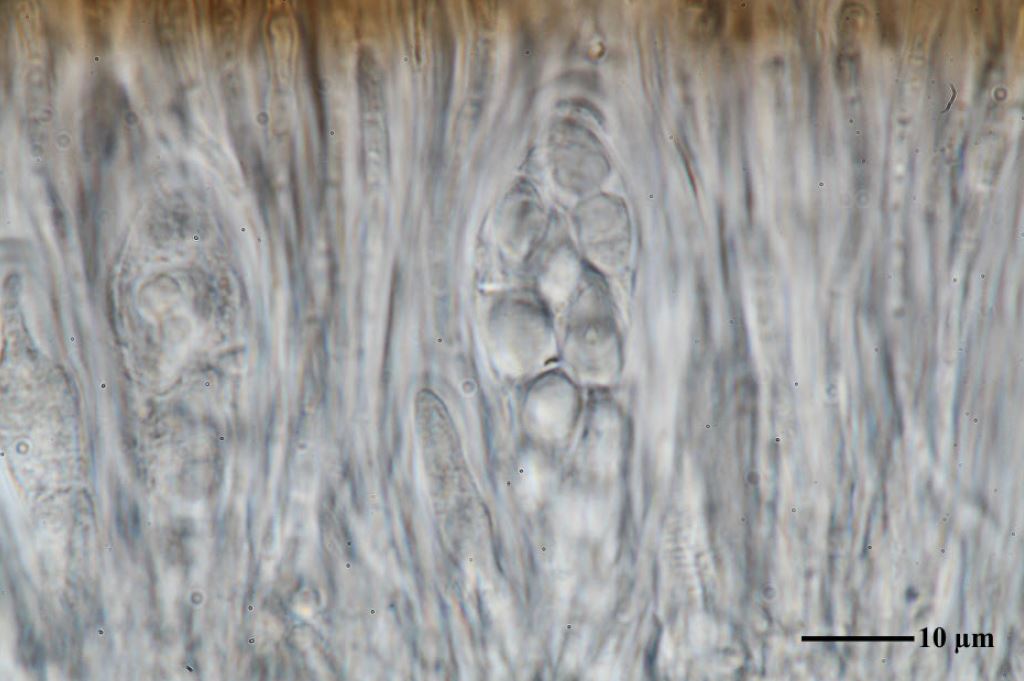
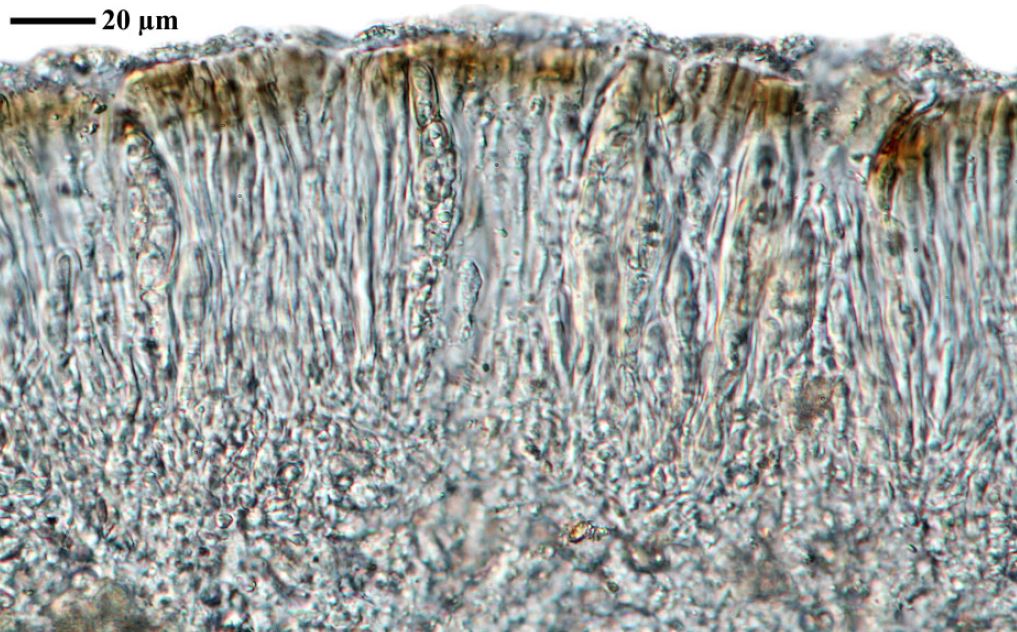
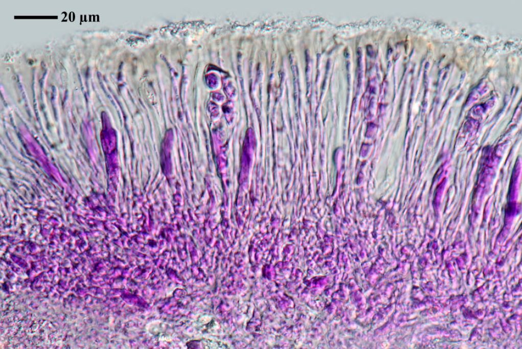
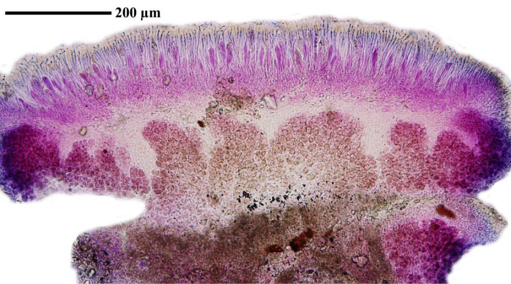
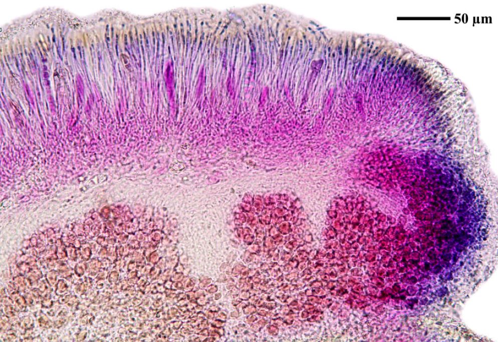
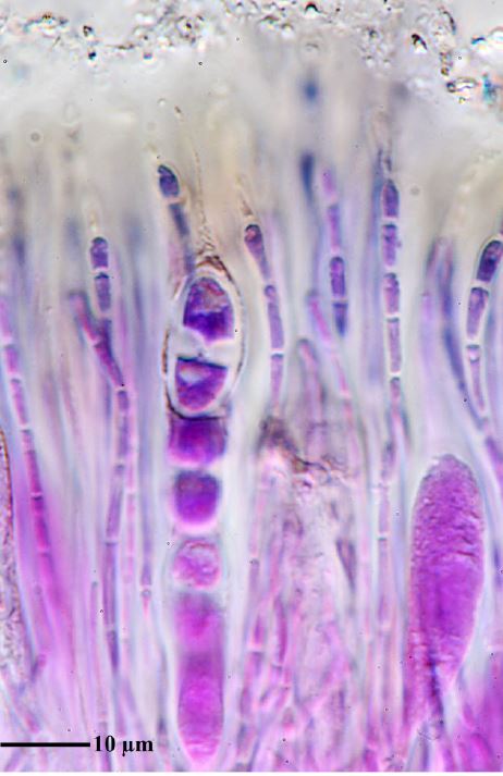
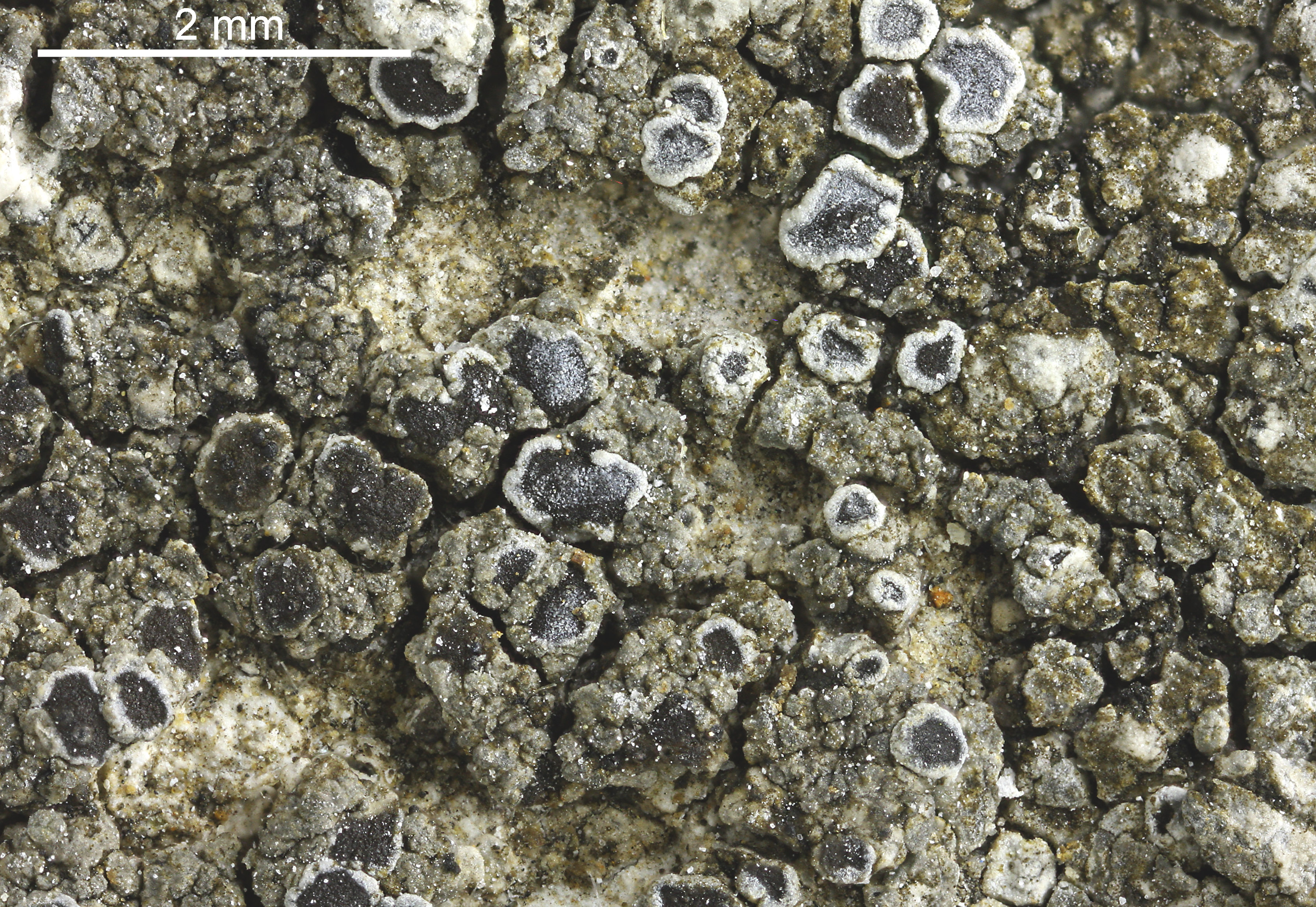
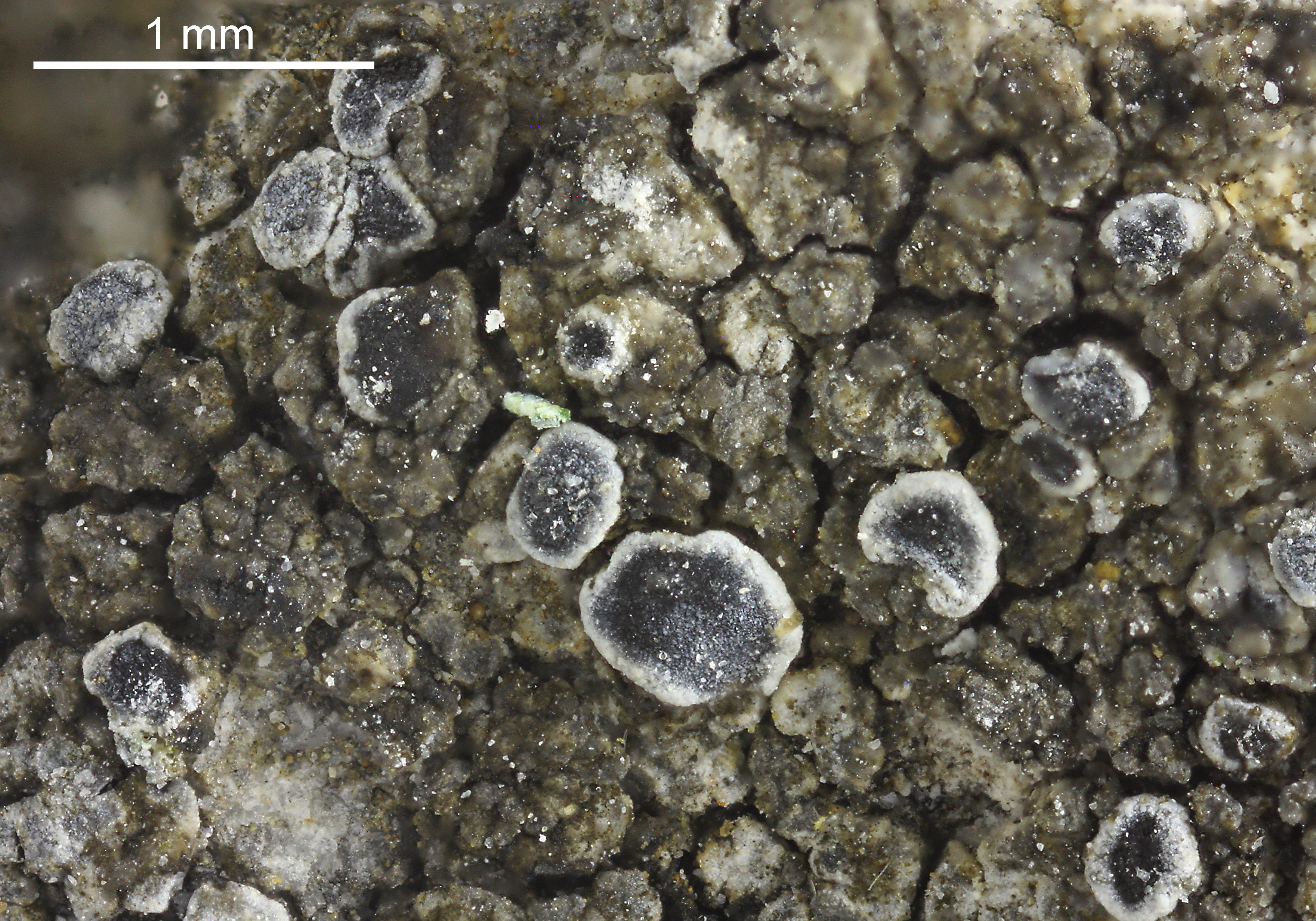
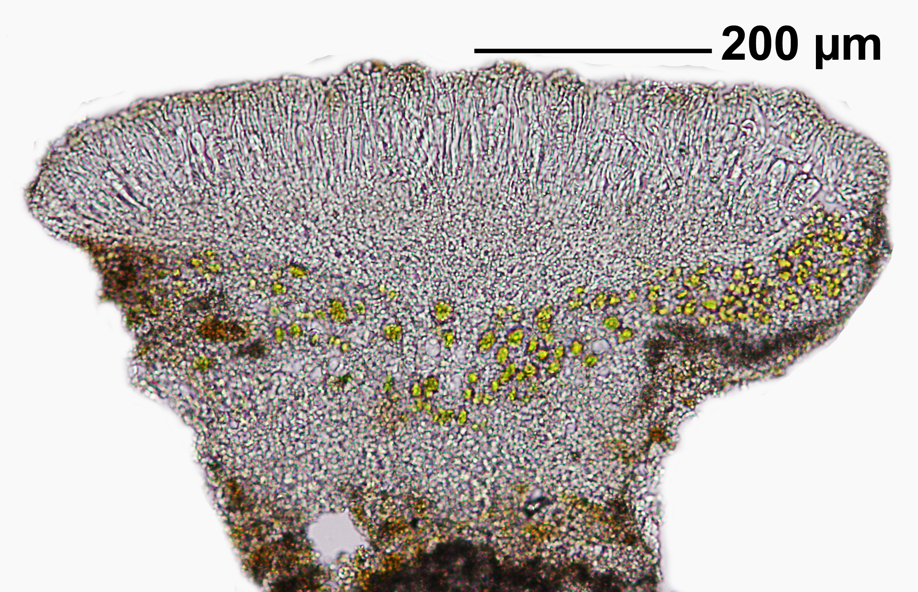
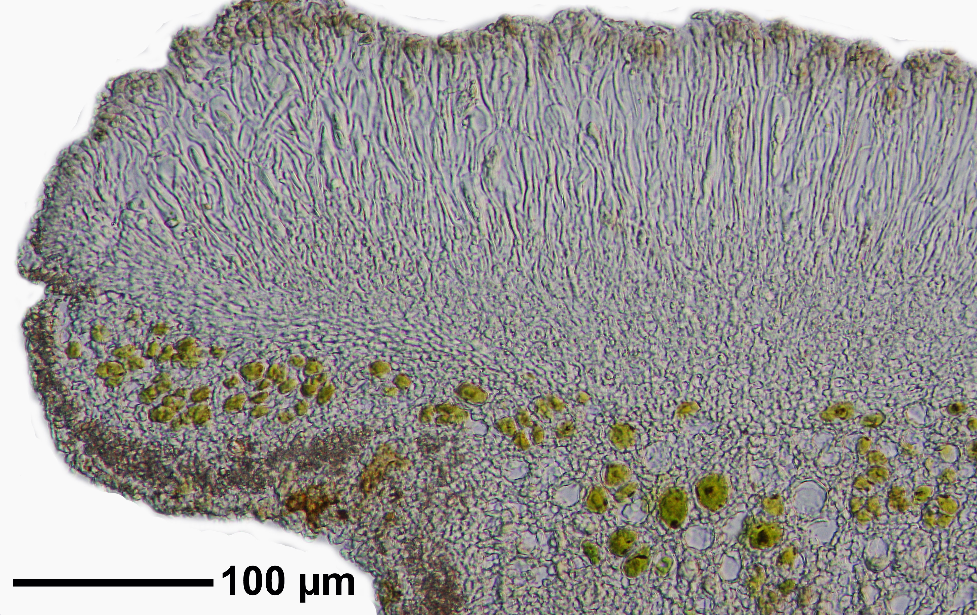
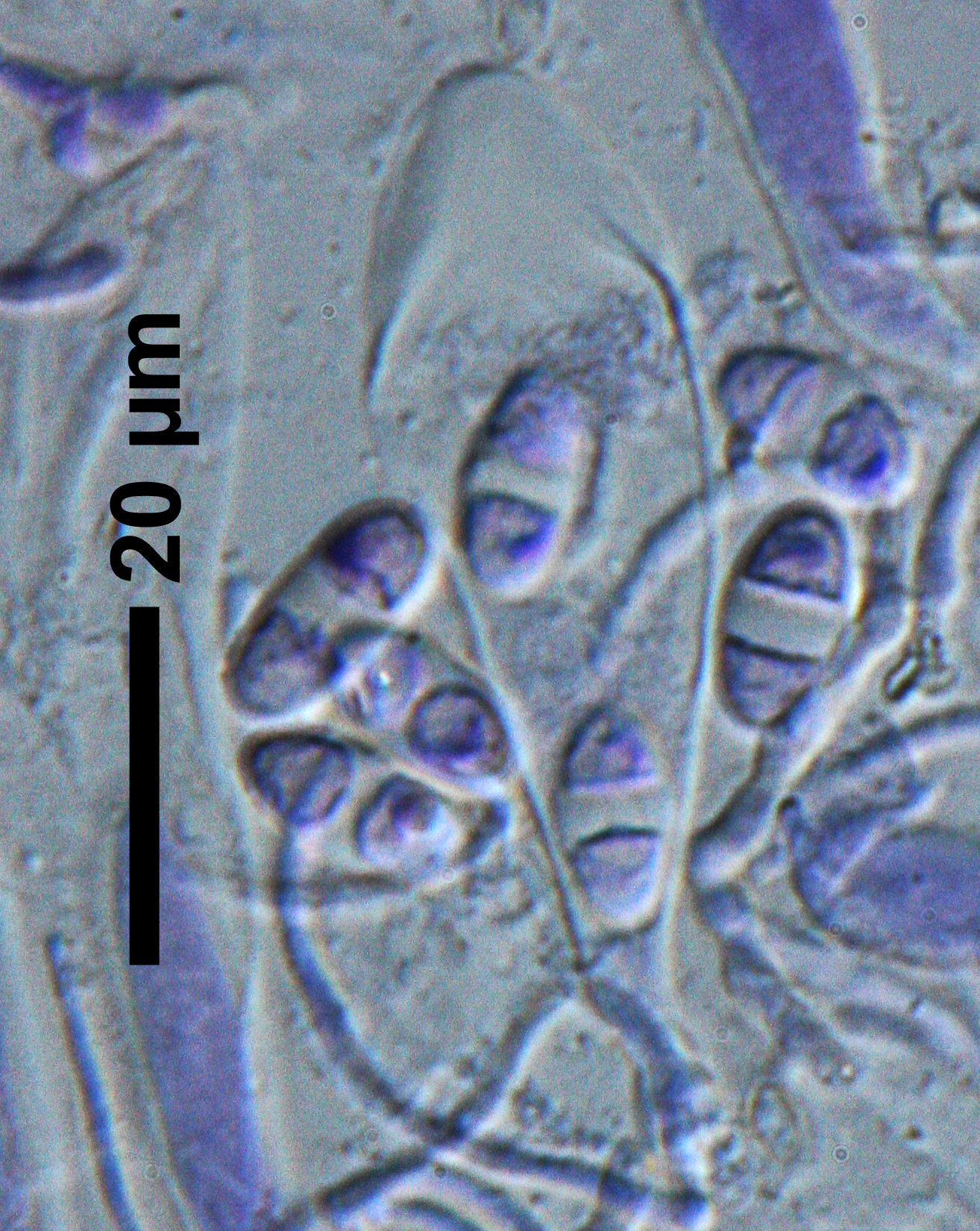
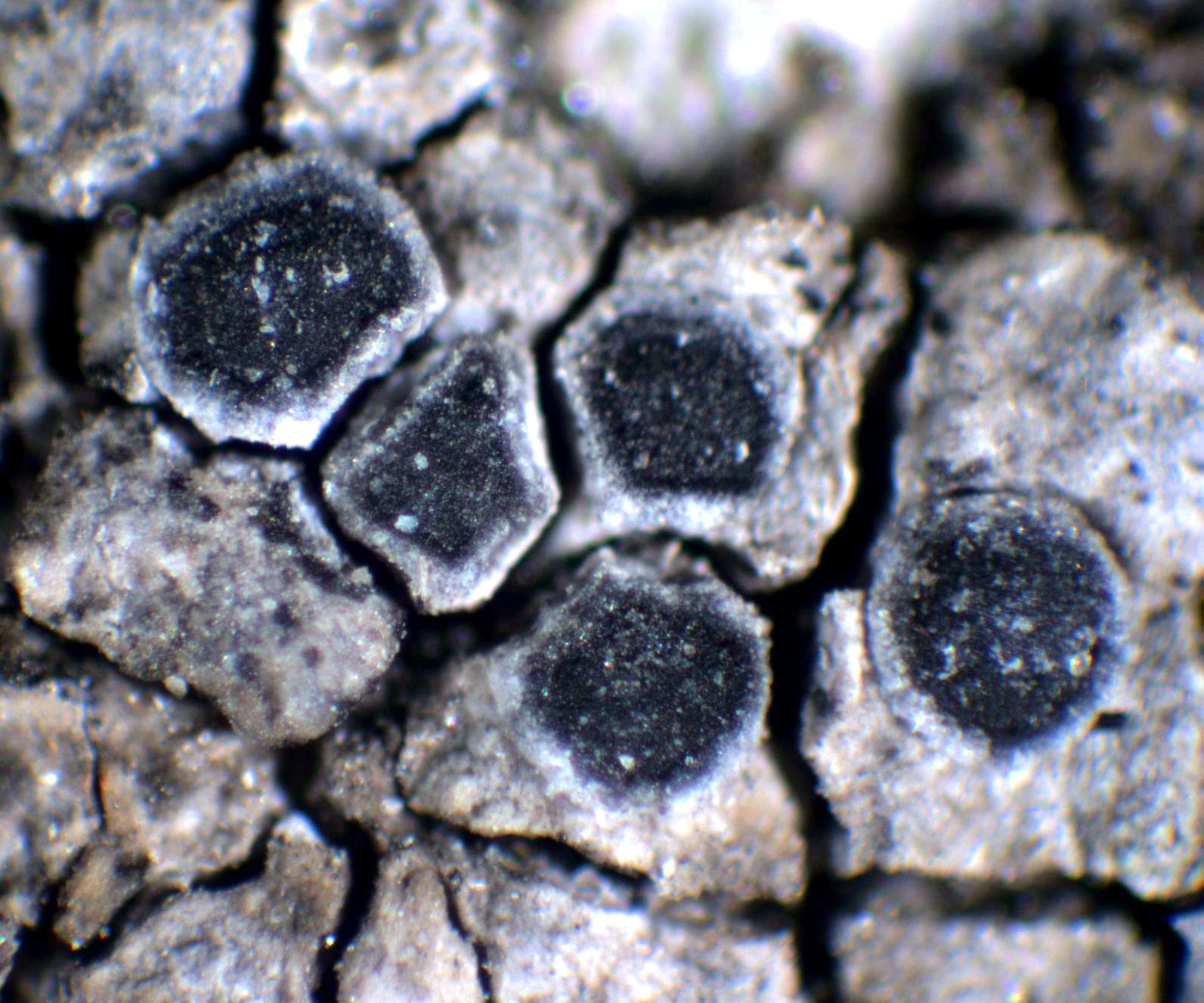
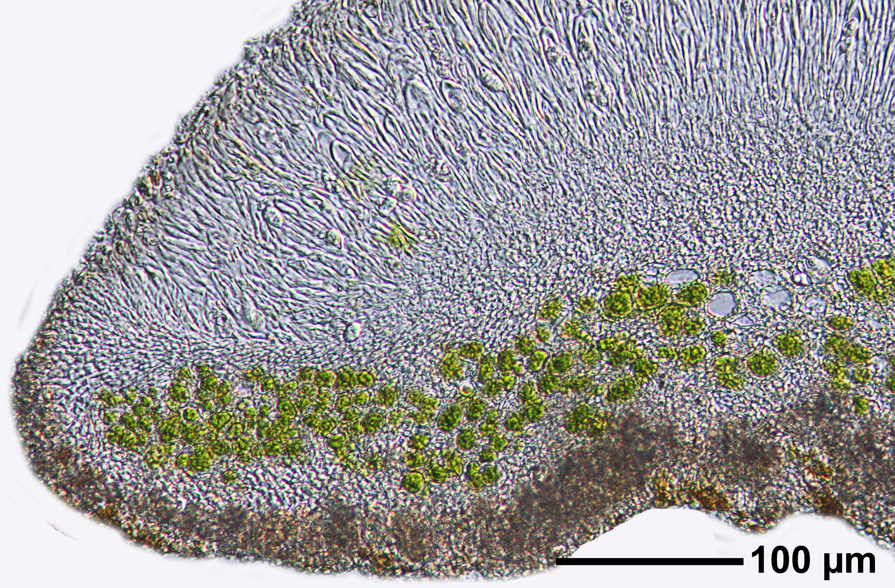
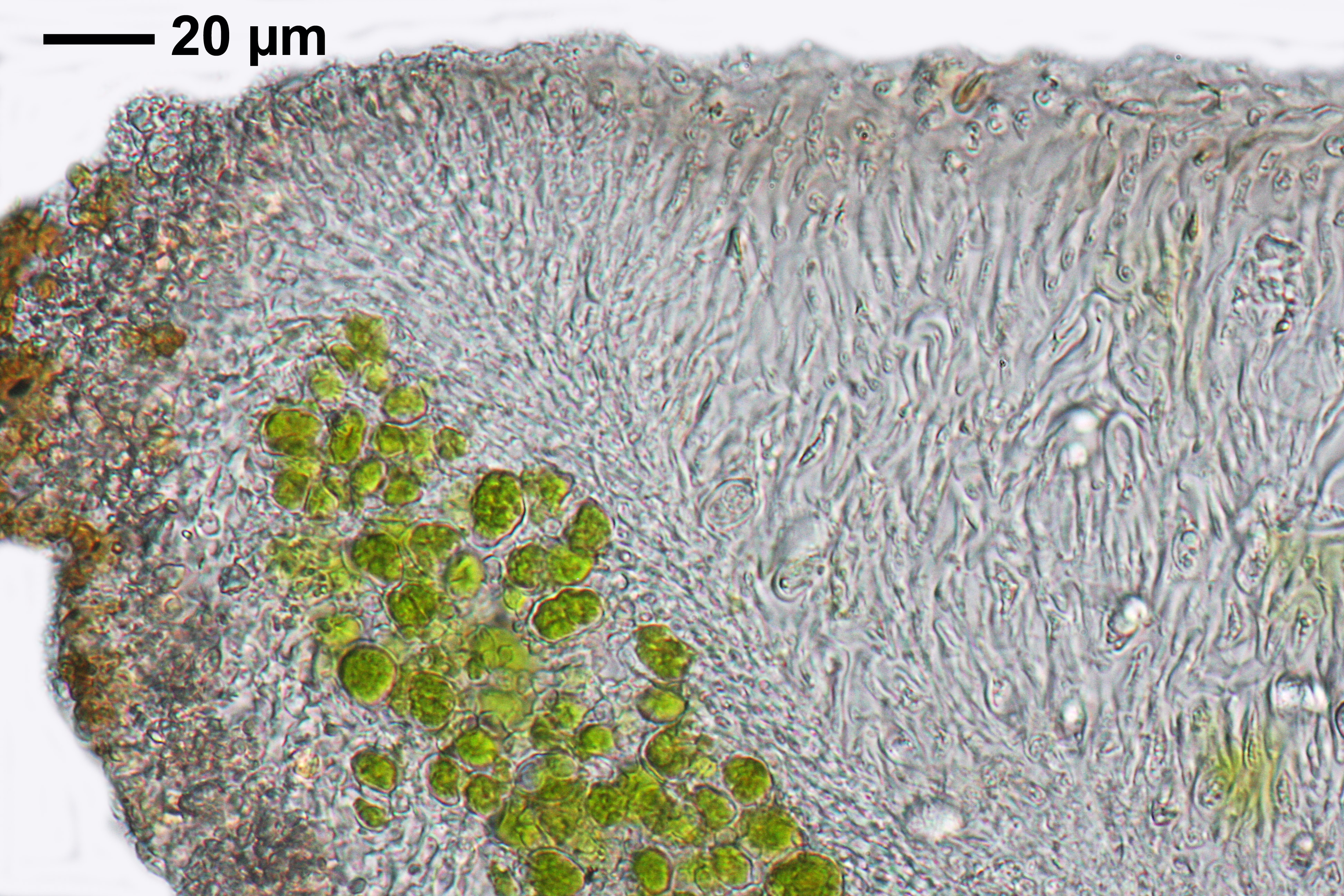
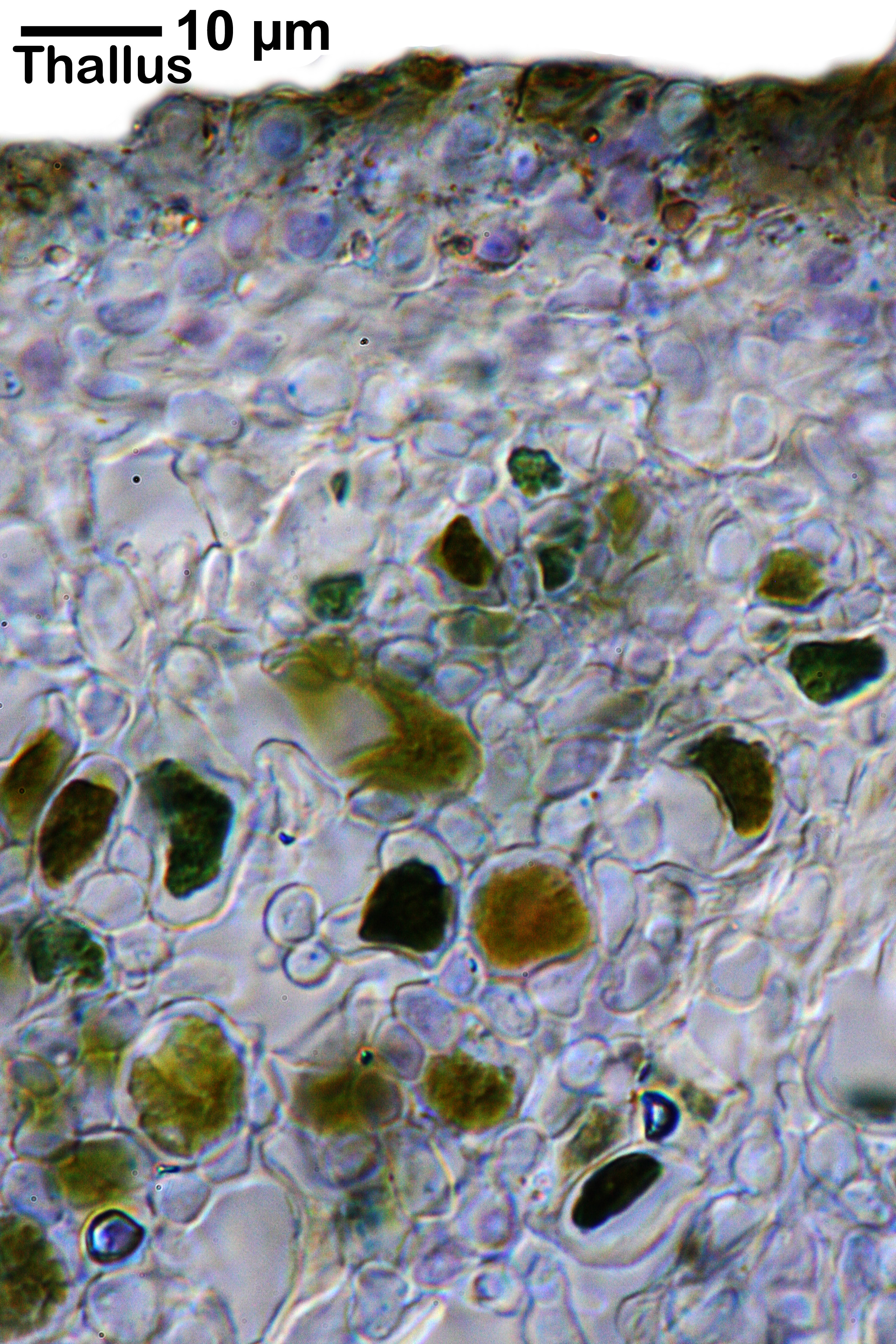
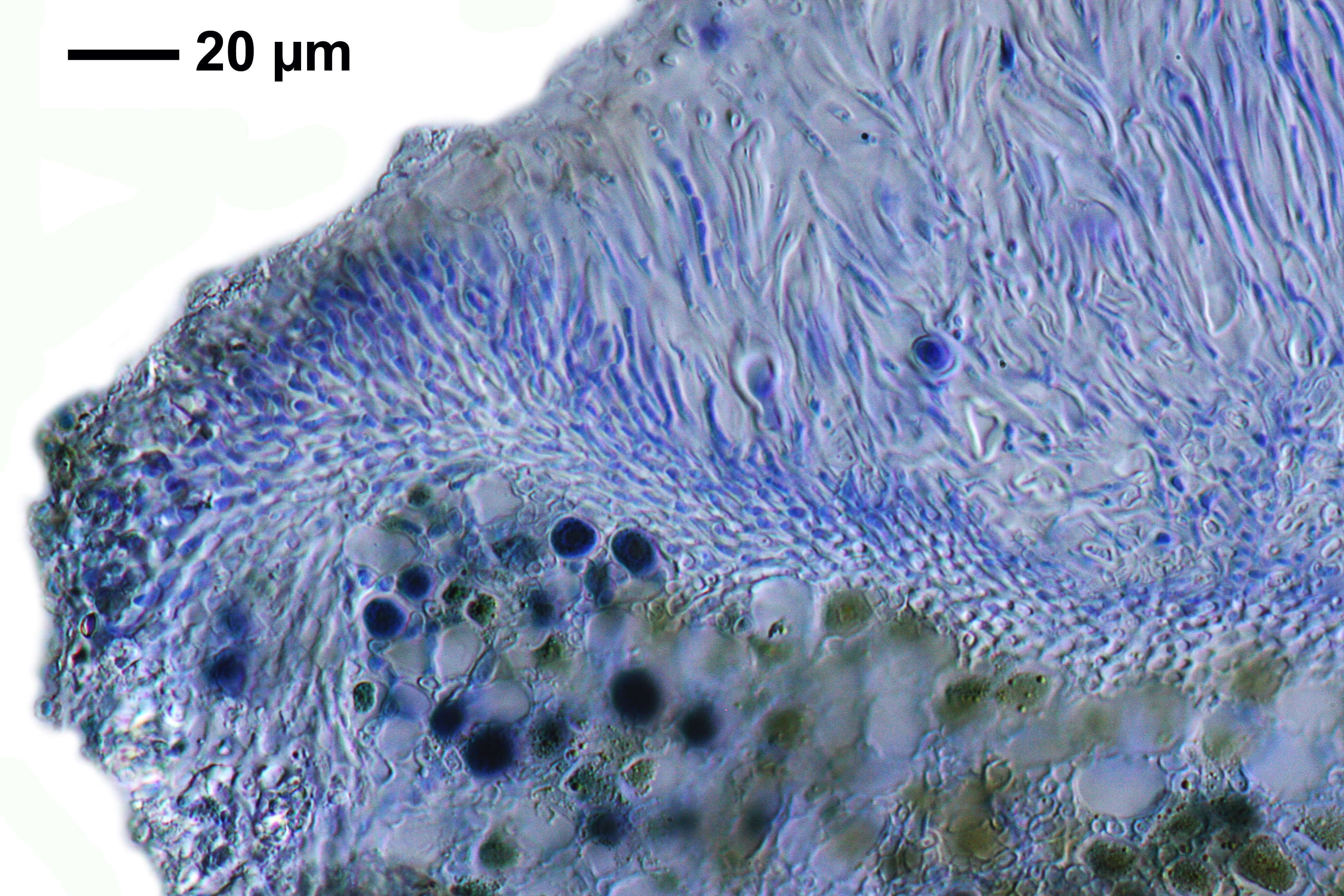
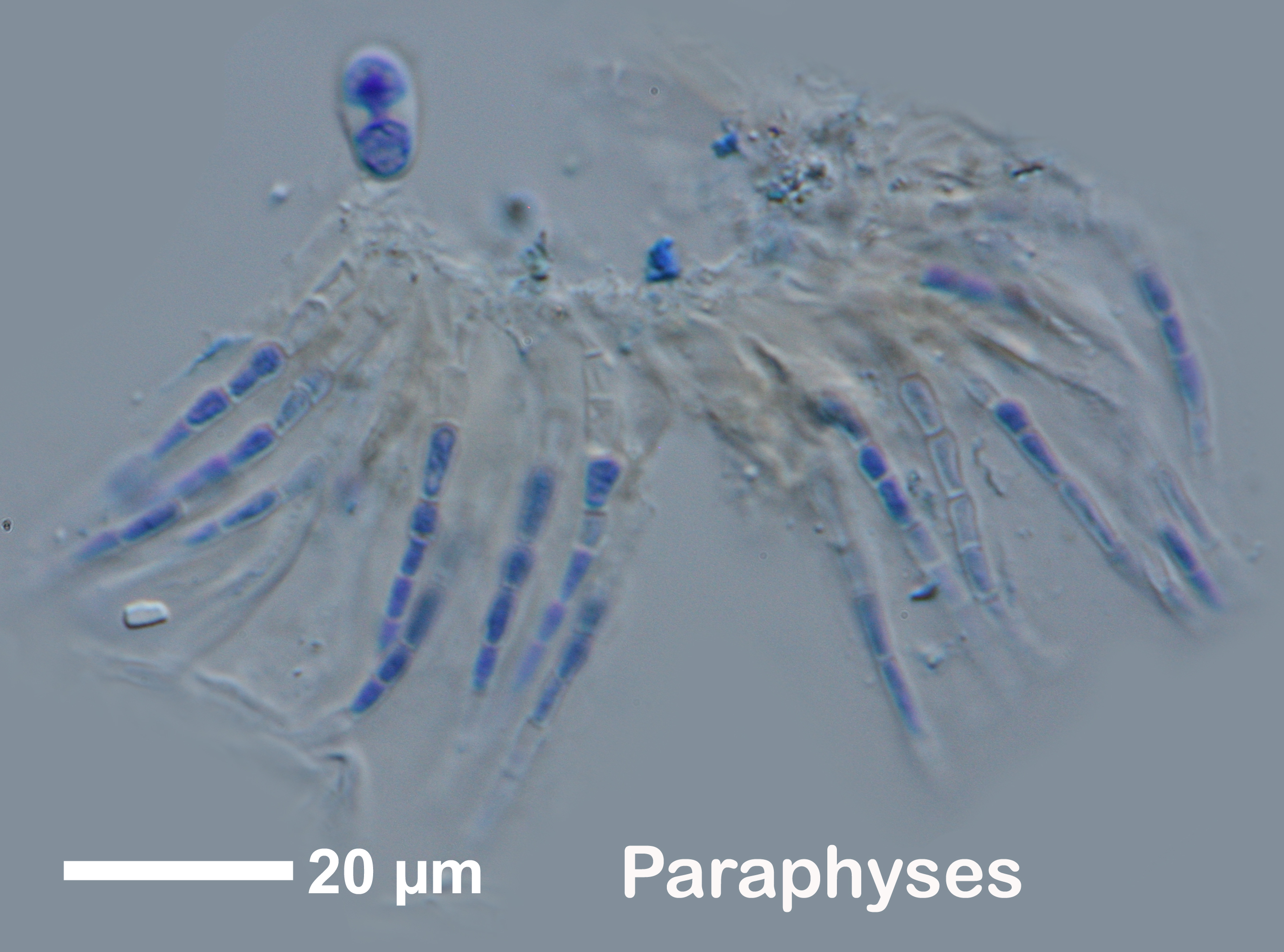
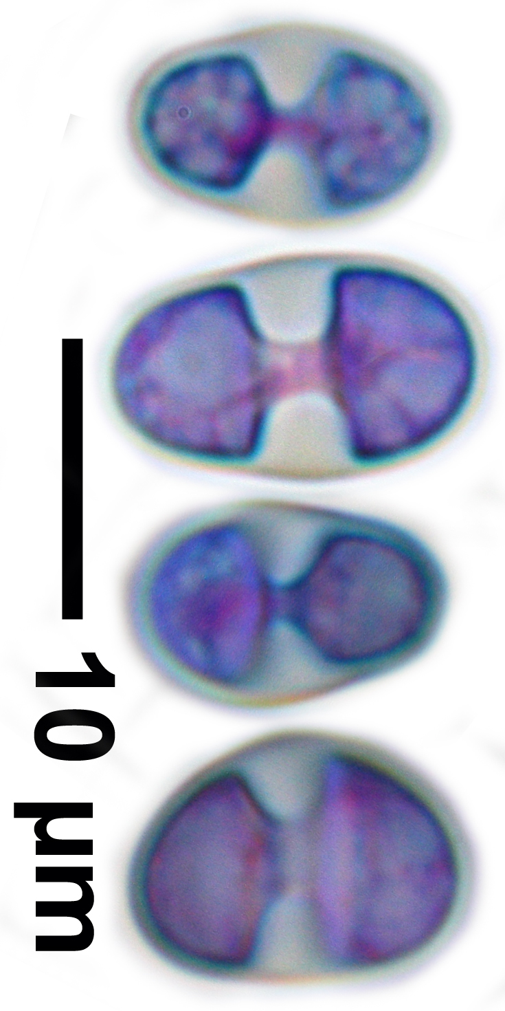
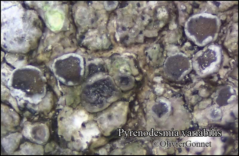
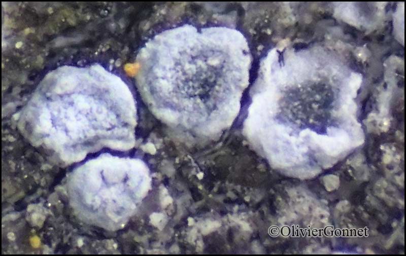
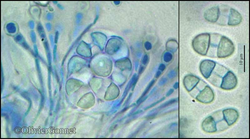
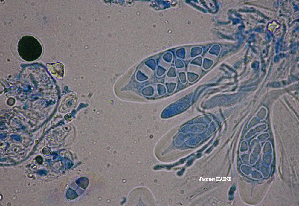
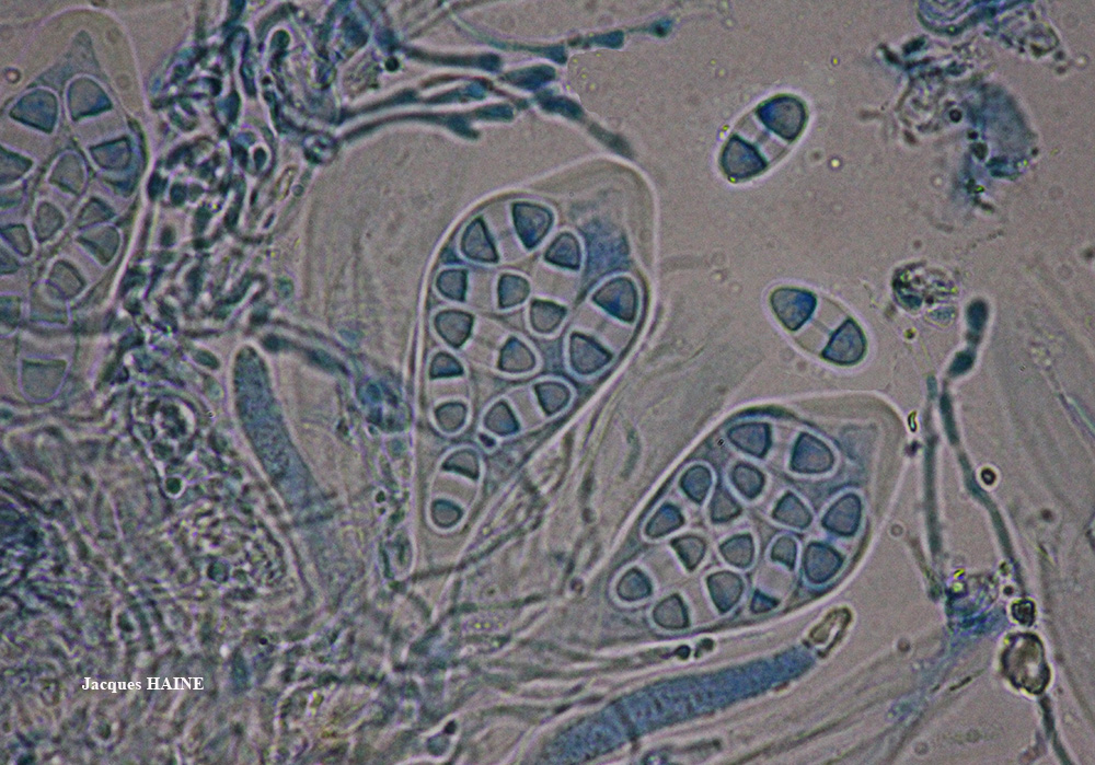
Description: Thallus crustose, episubstratic, rimose or areolate, whitish, dark grey or grey-brown, sometimes rust-brown, often paler in peripheral parts, forming irregular to orbicular patches usually delimited by a dark prothallus. Apothecia lecanorine, sessile, 0.5-1.2 mm across, with a flat to slightly convex, dark brown to black, often grey-blue-pruinose disc and an entire, whitish thalline margin. Proper exciple poorly developed, brown in outer part, colourless to brownish within, the pigmented parts K+ violet; epithecium grey, K+ violet; hymenium colourless, without crystals, 120-140 µm high; paraphyses 3-5 µm wide at apex; hypothecium colourless, without vertical rows of small, round-paraplectenchymatous cells. Asci 8-spored, clavate, functionally unitunicate, apically thickened with a broad internal beak, the inner part of apex and external cap I+ blue, Teloschistes-type. Ascospores 2-celled, polarilocular, ellipsoid, (12-)14-18(-25) x (6-)7-9(-10) µm, the equatorial thickening (“septum”) 3-7 µm. Photobiont chlorococcoid. Spot tests: thallus K- or K+ faintly violet, C-, KC-, P-, UV-; pigmented parts of apothecia K+ violet and sometimes N+ pale violet. Chemistry: Sedifolia-grey pigment in apothecia and sometimes in thallus.
Growth form: Crustose
Substrata: rocks
Photobiont: green algae other than Trentepohlia
Reproductive strategy: mainly sexual
Commonnes-rarity: (info)
Alpine belt: rather rare
Subalpine belt: rather common
Montane belt: rather common
Dry submediterranean belt: common
Humid submediterranean belt: very common
Padanian area: rare
pH of the substrata:
1 2 3 4 5

Solar irradiation:
1 2 3 4 5
Aridity:
1 2 3 4 5
Eutrophication:
1 2 3 4 5
Poleotolerance:
0 1 2 3
Altitudinal distribution:
1 2 3 4 5 6
Rarity
absent
extremely rare
very rare
rare
rather rare
rather common
common
very common
extremely common
Loading data...
Occurrence data
Predictive map

Felix Schumm CC BY-SA 4.0
[16513], Germany, Baden-Württemberg, Kreis Göppingen, Gosbach - Bad Ditzenbach, Tierstein, 48,57461° N, 9,68471° E, 737 m. auf Kalkfelsen am Albrand. Leg. Schumm 20.06.2010.

P.L. Nimis; Owner: Department of Life Sciences, University of Trieste
Herbarium: TSB (34657)
2002/01/31
P.L. Nimis; Owner: Department of Life Sciences, University of Trieste
Herbarium: TSB (34595)
2002/01/21
a specimen corresponding to f. ocellulata
Andres Saag; Owner: University of Tartu
Leif Stridvall - Source: http://www.stridvall.se/la/galleries.php (Courtesy: Anita Stridvall)

Felix Schumm – CC BY-SA 4.0
[13503], Griechenland, S-Kreta, Asteroussia Berge, an der Straße von Miamou nach Lentas, 11 km vor Lentas, 520 m, Felsen in Oleahain. Leg. F. Schumm & R. Düll, 23.10.2007, det. A. Aptroot 2016
Felix Schumm – CC BY-SA 4.0
[13503], Griechenland, S-Kreta, Asteroussia Berge, an der Straße von Miamou nach Lentas, 11 km vor Lentas, 520 m, Felsen in Oleahain. Leg. F. Schumm & R. Düll, 23.10.2007, det. A. Aptroot 2016
Felix Schumm – CC BY-SA 4.0
[13503], Griechenland, S-Kreta, Asteroussia Berge, an der Straße von Miamou nach Lentas, 11 km vor Lentas, 520 m, Felsen in Oleahain. Leg. F. Schumm & R. Düll, 23.10.2007, det. A. Aptroot 2016

Felix Schumm – CC BY-SA 4.0
[12293], Griechenland, N-Samos, bei Manolates südlich von Agios Konstandinos, 37°47.185'N, 26°49.533'E, 341 m; halbschattige bis besonnte Terrassenmauern. Leg. Schumm 02.05.2006, det. Schumm 2006.
Felix Schumm – CC BY-SA 4.0
[12293], Griechenland, N-Samos, bei Manolates südlich von Agios Konstandinos, 37°47.185'N, 26°49.533'E, 341 m; halbschattige bis besonnte Terrassenmauern. Leg. Schumm 02.05.2006, det. Schumm 2006.
Felix Schumm – CC BY-SA 4.0
[12293], Griechenland, N-Samos, bei Manolates südlich von Agios Konstandinos, 37°47.185'N, 26°49.533'E, 341 m; halbschattige bis besonnte Terrassenmauern. Leg. Schumm 02.05.2006, det. Schumm 2006.
Felix Schumm - CC BY-SA 4.0
[GZU 5-83], Afghanistan, Prov. Samangan, ca. 15 km W des Passes Kotal-i-Mirza Atbili (Kotal-i-Rabotak), ca 10 km E Aybak. 68°08’ E, 36°13’ N, ca. 1170 m. Auf Zenitflächen flachbankiger Kalke. Leg. M. Steiner (Ste 44/3), 05.06.1970. Det F. Schumm 2018.
Felix Schumm - CC BY-SA 4.0
[GZU 5-83], Afghanistan, Prov. Samangan, ca. 15 km W des Passes Kotal-i-Mirza Atbili (Kotal-i-Rabotak), ca 10 km E Aybak. 68°08’ E, 36°13’ N, ca. 1170 m. Auf Zenitflächen flachbankiger Kalke. Leg. M. Steiner (Ste 44/3), 05.06.1970. Det F. Schumm 2018.

Felix Schumm - CC BY-SA 4.0
[GZU 5-83], Afghanistan, Prov. Samangan, ca. 15 km W des Passes Kotal-i-Mirza Atbili (Kotal-i-Rabotak), ca 10 km E Aybak. 68°08’ E, 36°13’ N, ca. 1170 m. Auf Zenitflächen flachbankiger Kalke. Leg. M. Steiner (Ste 44/3), 05.06.1970. Det F. Schumm 2018.

Felix Schumm - CC BY-SA 4.0
[GZU 5-83], Afghanistan, Prov. Samangan, ca. 15 km W des Passes Kotal-i-Mirza Atbili (Kotal-i-Rabotak), ca 10 km E Aybak. 68°08’ E, 36°13’ N, ca. 1170 m. Auf Zenitflächen flachbankiger Kalke. Leg. M. Steiner (Ste 44/3), 05.06.1970. Det F. Schumm 2018.
Felix Schumm - CC BY-SA 4.0
[GZU 5-83], Afghanistan, Prov. Samangan, ca. 15 km W des Passes Kotal-i-Mirza Atbili (Kotal-i-Rabotak), ca 10 km E Aybak. 68°08’ E, 36°13’ N, ca. 1170 m. Auf Zenitflächen flachbankiger Kalke. Leg. M. Steiner (Ste 44/3), 05.06.1970. Det F. Schumm 2018.
Felix Schumm - CC BY-SA 4.0
[GZU 5-83], Afghanistan, Prov. Samangan, ca. 15 km W des Passes Kotal-i-Mirza Atbili (Kotal-i-Rabotak), ca 10 km E Aybak. 68°08’ E, 36°13’ N, ca. 1170 m. Auf Zenitflächen flachbankiger Kalke. Leg. M. Steiner (Ste 44/3), 05.06.1970. Det F. Schumm 2018.
Felix Schumm - CC BY-SA 4.0
[GZU 5-83], Afghanistan, Prov. Samangan, ca. 15 km W des Passes Kotal-i-Mirza Atbili (Kotal-i-Rabotak), ca 10 km E Aybak. 68°08’ E, 36°13’ N, ca. 1170 m. Auf Zenitflächen flachbankiger Kalke. Leg. M. Steiner (Ste 44/3), 05.06.1970. Det F. Schumm 2018.
Felix Schumm - CC BY-SA 4.0
[GZU 5-83], Afghanistan, Prov. Samangan, ca. 15 km W des Passes Kotal-i-Mirza Atbili (Kotal-i-Rabotak), ca 10 km E Aybak. 68°08’ E, 36°13’ N, ca. 1170 m. Auf Zenitflächen flachbankiger Kalke. Leg. M. Steiner (Ste 44/3), 05.06.1970. Det F. Schumm 2018.
Felix Schumm - CC BY-SA 4.0
[GZU 5-83], Afghanistan, Prov. Samangan, ca. 15 km W des Passes Kotal-i-Mirza Atbili (Kotal-i-Rabotak), ca 10 km E Aybak. 68°08’ E, 36°13’ N, ca. 1170 m. Auf Zenitflächen flachbankiger Kalke. Leg. M. Steiner (Ste 44/3), 05.06.1970. Det F. Schumm 2018.

Felix Schumm - CC BY-SA 4.0
[GZU 5-83], Afghanistan, Prov. Samangan, ca. 15 km W des Passes Kotal-i-Mirza Atbili (Kotal-i-Rabotak), ca 10 km E Aybak. 68°08’ E, 36°13’ N, ca. 1170 m. Auf Zenitflächen flachbankiger Kalke. Leg. M. Steiner (Ste 44/3), 05.06.1970. Det F. Schumm 2018.

Felix Schumm - CC BY-SA 4.0
[GZU 5-83], Afghanistan, Prov. Samangan, ca. 15 km W des Passes Kotal-i-Mirza Atbili (Kotal-i-Rabotak), ca 10 km E Aybak. 68°08’ E, 36°13’ N, ca. 1170 m. Auf Zenitflächen flachbankiger Kalke. Leg. M. Steiner (Ste 44/3), 05.06.1970. Det F. Schumm 2018.
Felix Schumm - CC BY-SA 4.0
[GZU 5-83], Afghanistan, Prov. Samangan, ca. 15 km W des Passes Kotal-i-Mirza Atbili (Kotal-i-Rabotak), ca 10 km E Aybak. 68°08’ E, 36°13’ N, ca. 1170 m. Auf Zenitflächen flachbankiger Kalke. Leg. M. Steiner (Ste 44/3), 05.06.1970. Det F. Schumm 2018.
Felix Schumm - CC BY-SA 4.0
[GZU 5-83], Afghanistan, Prov. Samangan, ca. 15 km W des Passes Kotal-i-Mirza Atbili (Kotal-i-Rabotak), ca 10 km E Aybak. 68°08’ E, 36°13’ N, ca. 1170 m. Auf Zenitflächen flachbankiger Kalke. Leg. M. Steiner (Ste 44/3), 05.06.1970. Det F. Schumm 2018.

Felix Schumm CC BY-SA 4.0
[16472], Germany, Baden-Württemberg, Kreis Esslingen, zwischen Owen und Burg Teck, im Xerobrometum am Westhang des Hohenbol, auf sonnigen Kalkblöcken, 48°35,708’ N, 9°27,724’ E, ca. 550 m. Leg. Schumm, 04.07.2004.

Felix Schumm CC BY-SA 4.0
[16472], Germany, Baden-Württemberg, Kreis Esslingen, zwischen Owen und Burg Teck, im Xerobrometum am Westhang des Hohenbol, auf sonnigen Kalkblöcken, 48°35,708’ N, 9°27,724’ E, ca. 550 m. Leg. Schumm, 04.07.2004.

Felix Schumm CC BY-SA 4.0
[16472], Germany, Baden-Württemberg, Kreis Esslingen, zwischen Owen und Burg Teck, im Xerobrometum am Westhang des Hohenbol, auf sonnigen Kalkblöcken, 48°35,708’ N, 9°27,724’ E, ca. 550 m. Leg. Schumm, 04.07.2004.
Felix Schumm CC BY-SA 4.0
[16472], Germany, Baden-Württemberg, Kreis Esslingen, zwischen Owen und Burg Teck, im Xerobrometum am Westhang des Hohenbol, auf sonnigen Kalkblöcken, 48°35,708’ N, 9°27,724’ E, ca. 550 m. Leg. Schumm, 04.07.2004.
Felix Schumm CC BY-SA 4.0
[16472], Germany, Baden-Württemberg, Kreis Esslingen, zwischen Owen und Burg Teck, im Xerobrometum am Westhang des Hohenbol, auf sonnigen Kalkblöcken, 48°35,708’ N, 9°27,724’ E, ca. 550 m. Leg. Schumm, 04.07.2004.
Felix Schumm CC BY-SA 4.0
[16472], Germany, Baden-Württemberg, Kreis Esslingen, zwischen Owen und Burg Teck, im Xerobrometum am Westhang des Hohenbol, auf sonnigen Kalkblöcken, 48°35,708’ N, 9°27,724’ E, ca. 550 m. Leg. Schumm, 04.07.2004.

Felix Schumm CC BY-SA 4.0
[16472], Germany, Baden-Württemberg, Kreis Esslingen, zwischen Owen und Burg Teck, im Xerobrometum am Westhang des Hohenbol, auf sonnigen Kalkblöcken, 48°35,708’ N, 9°27,724’ E, ca. 550 m. Leg. Schumm, 04.07.2004.
Felix Schumm CC BY-SA 4.0
[16472], Germany, Baden-Württemberg, Kreis Esslingen, zwischen Owen und Burg Teck, im Xerobrometum am Westhang des Hohenbol, auf sonnigen Kalkblöcken, 48°35,708’ N, 9°27,724’ E, ca. 550 m. Leg. Schumm, 04.07.2004.

P.L. Nimis CC BY-SA 4.0
TSB 2370
Felix Schumm CC BY-SA 4.0
[16513], Germany, Baden-Württemberg, Kreis Göppingen, Gosbach - Bad Ditzenbach, Tierstein, 48,57461° N, 9,68471° E, 737 m. auf Kalkfelsen am Albrand. Leg. Schumm 20.06.2010.
Felix Schumm CC BY-SA 4.0
[16513], Germany, Baden-Württemberg, Kreis Göppingen, Gosbach - Bad Ditzenbach, Tierstein, 48,57461° N, 9,68471° E, 737 m. auf Kalkfelsen am Albrand. Leg. Schumm 20.06.2010.
Felix Schumm CC BY-SA 4.0
[16513], Germany, Baden-Württemberg, Kreis Göppingen, Gosbach - Bad Ditzenbach, Tierstein, 48,57461° N, 9,68471° E, 737 m. auf Kalkfelsen am Albrand. Leg. Schumm 20.06.2010.

Felix Schumm CC BY-SA 4.0
[16513], Germany, Baden-Württemberg, Kreis Göppingen, Gosbach - Bad Ditzenbach, Tierstein, 48,57461° N, 9,68471° E, 737 m. auf Kalkfelsen am Albrand. Leg. Schumm 20.06.2010.
Felix Schumm CC BY-SA 4.0
[16513], Germany, Baden-Württemberg, Kreis Göppingen, Gosbach - Bad Ditzenbach, Tierstein, 48,57461° N, 9,68471° E, 737 m. auf Kalkfelsen am Albrand. Leg. Schumm 20.06.2010.
Felix Schumm CC BY-SA 4.0
[16513], Germany, Baden-Württemberg, Kreis Göppingen, Gosbach - Bad Ditzenbach, Tierstein, 48,57461° N, 9,68471° E, 737 m. auf Kalkfelsen am Albrand. Leg. Schumm 20.06.2010.

Felix Schumm CC BY-SA 4.0
[16513], Germany, Baden-Württemberg, Kreis Göppingen, Gosbach - Bad Ditzenbach, Tierstein, 48,57461° N, 9,68471° E, 737 m. auf Kalkfelsen am Albrand. Leg. Schumm 20.06.2010.
Felix Schumm CC BY-SA 4.0
[16513], Germany, Baden-Württemberg, Kreis Göppingen, Gosbach - Bad Ditzenbach, Tierstein, 48,57461° N, 9,68471° E, 737 m. auf Kalkfelsen am Albrand. Leg. Schumm 20.06.2010.
Felix Schumm CC BY-SA 4.0
[16513], Germany, Baden-Württemberg, Kreis Göppingen, Gosbach - Bad Ditzenbach, Tierstein, 48,57461° N, 9,68471° E, 737 m. auf Kalkfelsen am Albrand. Leg. Schumm 20.06.2010.
P.L. Nimis; Owner: Department of Life Sciences, University of Trieste
Herbarium: TSB (2370)
2001/11/19
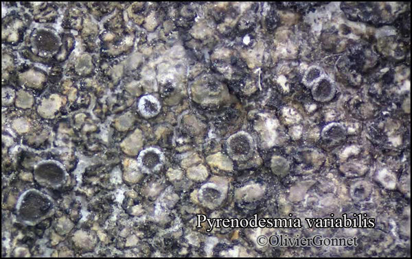
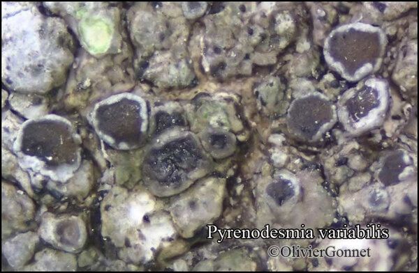
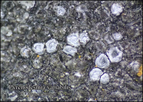
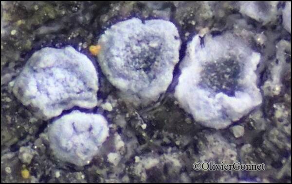
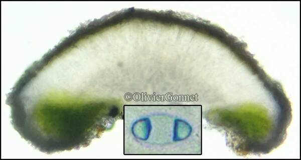
Courtesy Danièle et Olivier Gonnet - Source: https://www.afl-lichenologie.fr/Photos_AFL/Photos_AFL_P/Pyrenodesmia_variabilis.htm
France, 10/7/2015 - session AFL Bourgogne - Côte-d'Or
Courtesy Danièle et Olivier Gonnet - Source: https://www.afl-lichenologie.fr/Photos_AFL/Photos_AFL_P/Pyrenodesmia_variabilis.htm
France, 10/7/2015 - session AFL Bourgogne - Côte-d'Or
Courtesy Danièle et Olivier Gonnet - Source: https://www.afl-lichenologie.fr/Photos_AFL/Photos_AFL_P/Pyrenodesmia_variabilis.htm
France, 10/7/2015 - session AFL Bourgogne - Côte-d'Or
Courtesy Danièle et Olivier Gonnet - Source: https://www.afl-lichenologie.fr/Photos_AFL/Photos_AFL_P/Pyrenodesmia_variabilis.htm
France, 10/7/2015 - session AFL Bourgogne - Côte-d'Or
Courtesy Danièle et Olivier Gonnet - Source: https://www.afl-lichenologie.fr/Photos_AFL/Photos_AFL_P/Pyrenodesmia_variabilis.htm
France, 10/7/2015 - session AFL Bourgogne - Côte-d'Or
Courtesy Danièle et Olivier Gonnet - Source: https://www.afl-lichenologie.fr/Photos_AFL/Photos_AFL_P/Pyrenodesmia_variabilis.htm
France, 10/7/2015 - session AFL Bourgogne - Côte-d'Or
Courtesy Danièle et Olivier Gonnet - Source: https://www.afl-lichenologie.fr/Photos_AFL/Photos_AFL_P/Pyrenodesmia_variabilis.htm
France, 10/7/2015 - session AFL Bourgogne - Côte-d'Or

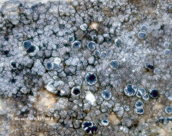
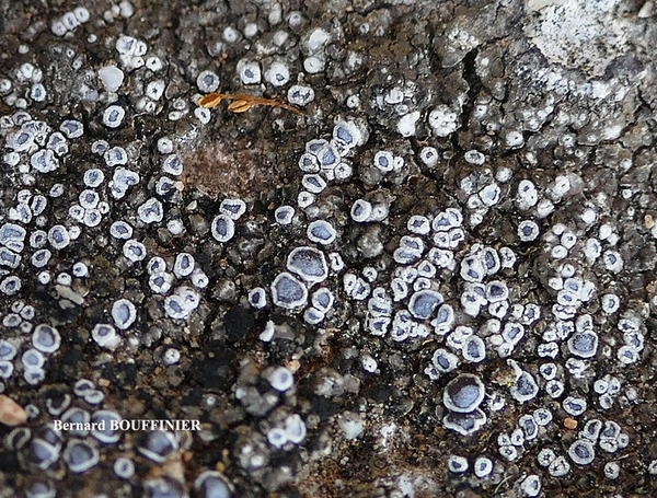
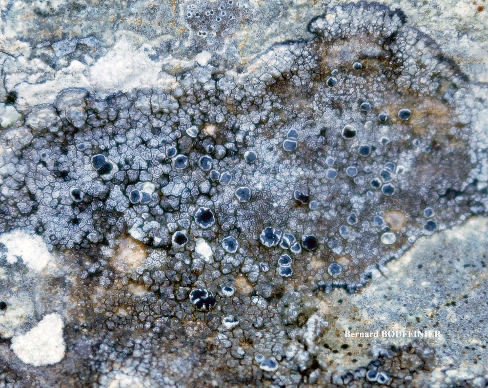
Berbard Bouffinier - Source: http://www.lichensmaritimes.org/index.php?task=fiche&lichen=830&lang=en
France, Corse, Barbaggio
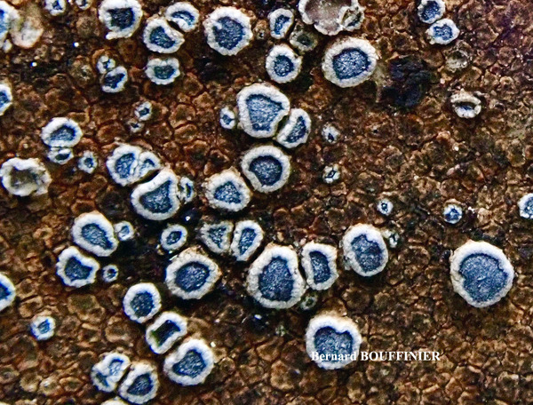
Berbard Bouffinier - Source: http://www.lichensmaritimes.org/index.php?task=fiche&lichen=830&lang=en
France, Corse, Barbaggio

Berbard Bouffinier - Source: http://www.lichensmaritimes.org/index.php?task=fiche&lichen=830&lang=en
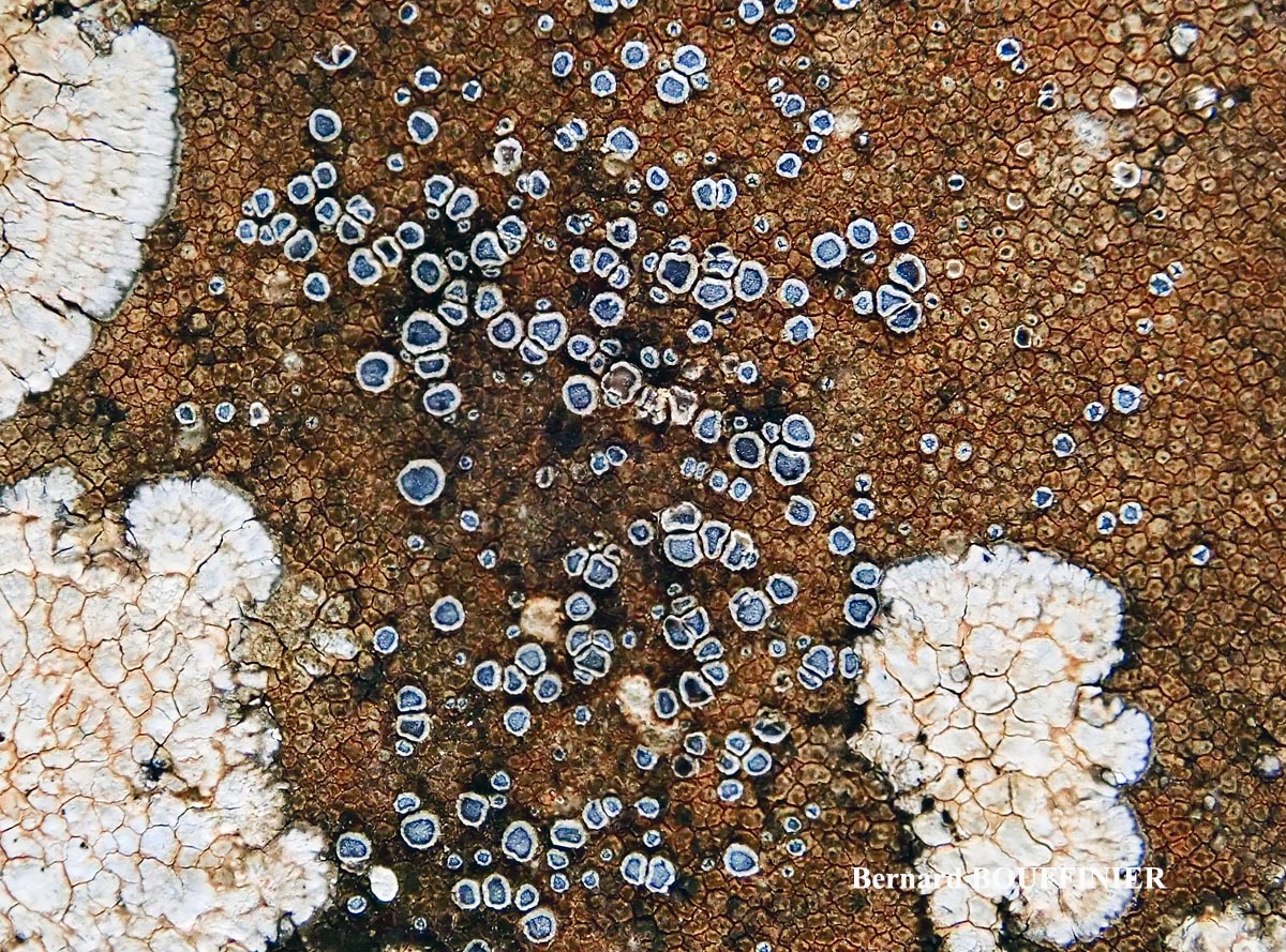
France, Provence, Esparron
Berbard Bouffinier - Source: http://www.lichensmaritimes.org/index.php?task=fiche&lichen=830&lang=en
France, Corse, Patrimonio

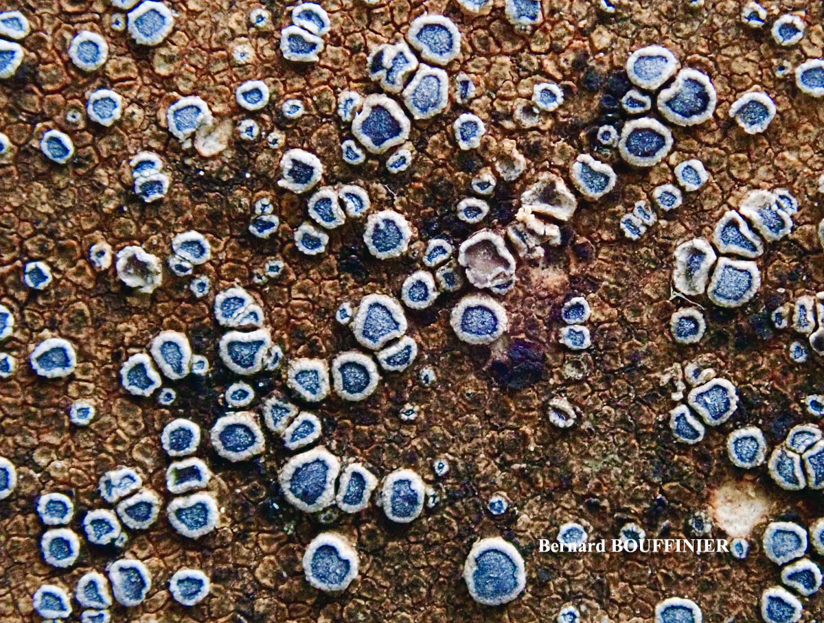
Berbard Bouffinier - Source: http://www.lichensmaritimes.org/index.php?task=fiche&lichen=830&lang=en
France, Provence, Esparron
Berbard Bouffinier - Source: http://www.lichensmaritimes.org/index.php?task=fiche&lichen=830&lang=en
France, Provence, Esparron
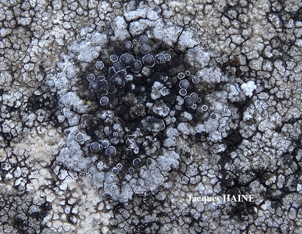
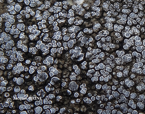
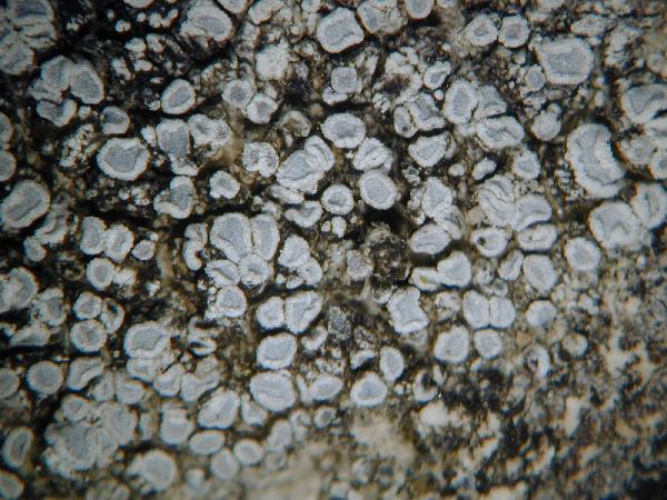
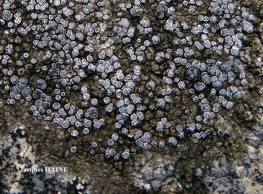
Jacques Haine - Source: http://www.lichensmaritimes.org/index.php?task=fiche&lichen=830&lang=en
France, Ardenne
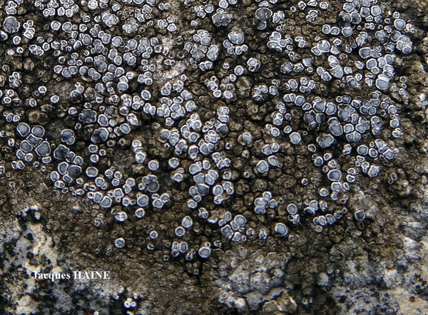
Jacques Haine - Source: http://www.lichensmaritimes.org/index.php?task=fiche&lichen=830&lang=en
France, Ardenne
Jacques Haine - Source: http://www.lichensmaritimes.org/index.php?task=fiche&lichen=830&lang=en
France, Ardenne

Jacques Haine - Source: http://www.lichensmaritimes.org/index.php?task=fiche&lichen=830&lang=en
France, Ardenne

Jacques Haine - Source: http://www.lichensmaritimes.org/index.php?task=fiche&lichen=830&lang=en
France, Ardenne
Wolfgang von Brackel - CC BY-4.0
Germany, Bavaria, Hohenfels

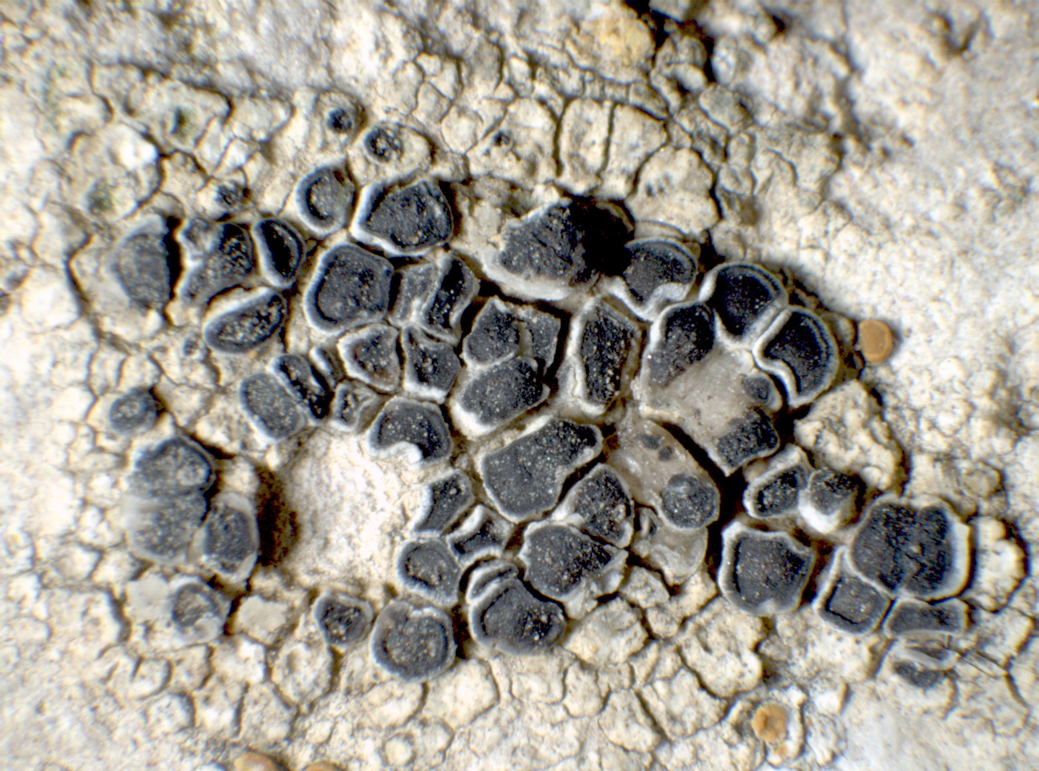
Collezione lichenologica Abramo Massalongo del Museo di Storia Naturale G. Ligabue di Venezia - Autori: Seggi, Linda; Trabucco, Raffaella Proprietà: Fondazione Musei Civici di Venezia - CC BY-NC
Italy, Veneto, Ad saxa dolomitica montis Alba 1855

Collezione lichenologica Abramo Massalongo del Museo di Storia Naturale G. Ligabue di Venezia - Autori: Seggi, Linda; Trabucco, Raffaella Proprietà: Fondazione Musei Civici di Venezia - CC BY-NC
Italy, Veneto, in oppido Asiago 1855
as Pyrenodesmia variabillis var. fusca A. Massal.
Growth form: Crustose
Substrata: rocks
Photobiont: green algae other than Trentepohlia
Reproductive strategy: mainly sexual
Commonnes-rarity: (info)
Alpine belt: rather rare
Subalpine belt: rather common
Montane belt: rather common
Dry submediterranean belt: common
Humid submediterranean belt: very common
Padanian area: rare
pH of the substrata:
| 1 | 2 | 3 | 4 | 5 |
Solar irradiation:
| 1 | 2 | 3 | 4 | 5 |
Aridity:
| 1 | 2 | 3 | 4 | 5 |
Eutrophication:
| 1 | 2 | 3 | 4 | 5 |
Poleotolerance:
| 0 | 1 | 2 | 3 |
Altitudinal distribution:
| 1 | 2 | 3 | 4 | 5 | 6 |
Rarity
absent
extremely rare
very rare
rare
rather rare
rather common
common
very common
extremely common
Loading data...
Occurrence data
Predictive map
Felix Schumm CC BY-SA 4.0
[16513], Germany, Baden-Württemberg, Kreis Göppingen, Gosbach - Bad Ditzenbach, Tierstein, 48,57461° N, 9,68471° E, 737 m. auf Kalkfelsen am Albrand. Leg. Schumm 20.06.2010.
P.L. Nimis; Owner: Department of Life Sciences, University of Trieste
Herbarium: TSB (34657)
2002/01/31
P.L. Nimis; Owner: Department of Life Sciences, University of Trieste
Herbarium: TSB (34595)
2002/01/21
a specimen corresponding to f. ocellulata

Andres Saag; Owner: University of Tartu
Leif Stridvall - Source: http://www.stridvall.se/la/galleries.php (Courtesy: Anita Stridvall)
Felix Schumm – CC BY-SA 4.0
[13503], Griechenland, S-Kreta, Asteroussia Berge, an der Straße von Miamou nach Lentas, 11 km vor Lentas, 520 m, Felsen in Oleahain. Leg. F. Schumm & R. Düll, 23.10.2007, det. A. Aptroot 2016
Felix Schumm – CC BY-SA 4.0
[13503], Griechenland, S-Kreta, Asteroussia Berge, an der Straße von Miamou nach Lentas, 11 km vor Lentas, 520 m, Felsen in Oleahain. Leg. F. Schumm & R. Düll, 23.10.2007, det. A. Aptroot 2016
Felix Schumm – CC BY-SA 4.0
[13503], Griechenland, S-Kreta, Asteroussia Berge, an der Straße von Miamou nach Lentas, 11 km vor Lentas, 520 m, Felsen in Oleahain. Leg. F. Schumm & R. Düll, 23.10.2007, det. A. Aptroot 2016
Felix Schumm – CC BY-SA 4.0
[12293], Griechenland, N-Samos, bei Manolates südlich von Agios Konstandinos, 37°47.185'N, 26°49.533'E, 341 m; halbschattige bis besonnte Terrassenmauern. Leg. Schumm 02.05.2006, det. Schumm 2006.
Felix Schumm – CC BY-SA 4.0
[12293], Griechenland, N-Samos, bei Manolates südlich von Agios Konstandinos, 37°47.185'N, 26°49.533'E, 341 m; halbschattige bis besonnte Terrassenmauern. Leg. Schumm 02.05.2006, det. Schumm 2006.

Felix Schumm – CC BY-SA 4.0
[12293], Griechenland, N-Samos, bei Manolates südlich von Agios Konstandinos, 37°47.185'N, 26°49.533'E, 341 m; halbschattige bis besonnte Terrassenmauern. Leg. Schumm 02.05.2006, det. Schumm 2006.

Felix Schumm - CC BY-SA 4.0
[GZU 5-83], Afghanistan, Prov. Samangan, ca. 15 km W des Passes Kotal-i-Mirza Atbili (Kotal-i-Rabotak), ca 10 km E Aybak. 68°08’ E, 36°13’ N, ca. 1170 m. Auf Zenitflächen flachbankiger Kalke. Leg. M. Steiner (Ste 44/3), 05.06.1970. Det F. Schumm 2018.

Felix Schumm - CC BY-SA 4.0
[GZU 5-83], Afghanistan, Prov. Samangan, ca. 15 km W des Passes Kotal-i-Mirza Atbili (Kotal-i-Rabotak), ca 10 km E Aybak. 68°08’ E, 36°13’ N, ca. 1170 m. Auf Zenitflächen flachbankiger Kalke. Leg. M. Steiner (Ste 44/3), 05.06.1970. Det F. Schumm 2018.
Felix Schumm - CC BY-SA 4.0
[GZU 5-83], Afghanistan, Prov. Samangan, ca. 15 km W des Passes Kotal-i-Mirza Atbili (Kotal-i-Rabotak), ca 10 km E Aybak. 68°08’ E, 36°13’ N, ca. 1170 m. Auf Zenitflächen flachbankiger Kalke. Leg. M. Steiner (Ste 44/3), 05.06.1970. Det F. Schumm 2018.
Felix Schumm - CC BY-SA 4.0
[GZU 5-83], Afghanistan, Prov. Samangan, ca. 15 km W des Passes Kotal-i-Mirza Atbili (Kotal-i-Rabotak), ca 10 km E Aybak. 68°08’ E, 36°13’ N, ca. 1170 m. Auf Zenitflächen flachbankiger Kalke. Leg. M. Steiner (Ste 44/3), 05.06.1970. Det F. Schumm 2018.
Felix Schumm - CC BY-SA 4.0
[GZU 5-83], Afghanistan, Prov. Samangan, ca. 15 km W des Passes Kotal-i-Mirza Atbili (Kotal-i-Rabotak), ca 10 km E Aybak. 68°08’ E, 36°13’ N, ca. 1170 m. Auf Zenitflächen flachbankiger Kalke. Leg. M. Steiner (Ste 44/3), 05.06.1970. Det F. Schumm 2018.
Felix Schumm - CC BY-SA 4.0
[GZU 5-83], Afghanistan, Prov. Samangan, ca. 15 km W des Passes Kotal-i-Mirza Atbili (Kotal-i-Rabotak), ca 10 km E Aybak. 68°08’ E, 36°13’ N, ca. 1170 m. Auf Zenitflächen flachbankiger Kalke. Leg. M. Steiner (Ste 44/3), 05.06.1970. Det F. Schumm 2018.
Felix Schumm - CC BY-SA 4.0
[GZU 5-83], Afghanistan, Prov. Samangan, ca. 15 km W des Passes Kotal-i-Mirza Atbili (Kotal-i-Rabotak), ca 10 km E Aybak. 68°08’ E, 36°13’ N, ca. 1170 m. Auf Zenitflächen flachbankiger Kalke. Leg. M. Steiner (Ste 44/3), 05.06.1970. Det F. Schumm 2018.
Felix Schumm - CC BY-SA 4.0
[GZU 5-83], Afghanistan, Prov. Samangan, ca. 15 km W des Passes Kotal-i-Mirza Atbili (Kotal-i-Rabotak), ca 10 km E Aybak. 68°08’ E, 36°13’ N, ca. 1170 m. Auf Zenitflächen flachbankiger Kalke. Leg. M. Steiner (Ste 44/3), 05.06.1970. Det F. Schumm 2018.
Felix Schumm - CC BY-SA 4.0
[GZU 5-83], Afghanistan, Prov. Samangan, ca. 15 km W des Passes Kotal-i-Mirza Atbili (Kotal-i-Rabotak), ca 10 km E Aybak. 68°08’ E, 36°13’ N, ca. 1170 m. Auf Zenitflächen flachbankiger Kalke. Leg. M. Steiner (Ste 44/3), 05.06.1970. Det F. Schumm 2018.
Felix Schumm - CC BY-SA 4.0
[GZU 5-83], Afghanistan, Prov. Samangan, ca. 15 km W des Passes Kotal-i-Mirza Atbili (Kotal-i-Rabotak), ca 10 km E Aybak. 68°08’ E, 36°13’ N, ca. 1170 m. Auf Zenitflächen flachbankiger Kalke. Leg. M. Steiner (Ste 44/3), 05.06.1970. Det F. Schumm 2018.
Felix Schumm - CC BY-SA 4.0
[GZU 5-83], Afghanistan, Prov. Samangan, ca. 15 km W des Passes Kotal-i-Mirza Atbili (Kotal-i-Rabotak), ca 10 km E Aybak. 68°08’ E, 36°13’ N, ca. 1170 m. Auf Zenitflächen flachbankiger Kalke. Leg. M. Steiner (Ste 44/3), 05.06.1970. Det F. Schumm 2018.
Felix Schumm - CC BY-SA 4.0
[GZU 5-83], Afghanistan, Prov. Samangan, ca. 15 km W des Passes Kotal-i-Mirza Atbili (Kotal-i-Rabotak), ca 10 km E Aybak. 68°08’ E, 36°13’ N, ca. 1170 m. Auf Zenitflächen flachbankiger Kalke. Leg. M. Steiner (Ste 44/3), 05.06.1970. Det F. Schumm 2018.

Felix Schumm - CC BY-SA 4.0
[GZU 5-83], Afghanistan, Prov. Samangan, ca. 15 km W des Passes Kotal-i-Mirza Atbili (Kotal-i-Rabotak), ca 10 km E Aybak. 68°08’ E, 36°13’ N, ca. 1170 m. Auf Zenitflächen flachbankiger Kalke. Leg. M. Steiner (Ste 44/3), 05.06.1970. Det F. Schumm 2018.
Felix Schumm CC BY-SA 4.0
[16472], Germany, Baden-Württemberg, Kreis Esslingen, zwischen Owen und Burg Teck, im Xerobrometum am Westhang des Hohenbol, auf sonnigen Kalkblöcken, 48°35,708’ N, 9°27,724’ E, ca. 550 m. Leg. Schumm, 04.07.2004.
Felix Schumm CC BY-SA 4.0
[16472], Germany, Baden-Württemberg, Kreis Esslingen, zwischen Owen und Burg Teck, im Xerobrometum am Westhang des Hohenbol, auf sonnigen Kalkblöcken, 48°35,708’ N, 9°27,724’ E, ca. 550 m. Leg. Schumm, 04.07.2004.
Felix Schumm CC BY-SA 4.0
[16472], Germany, Baden-Württemberg, Kreis Esslingen, zwischen Owen und Burg Teck, im Xerobrometum am Westhang des Hohenbol, auf sonnigen Kalkblöcken, 48°35,708’ N, 9°27,724’ E, ca. 550 m. Leg. Schumm, 04.07.2004.

Felix Schumm CC BY-SA 4.0
[16472], Germany, Baden-Württemberg, Kreis Esslingen, zwischen Owen und Burg Teck, im Xerobrometum am Westhang des Hohenbol, auf sonnigen Kalkblöcken, 48°35,708’ N, 9°27,724’ E, ca. 550 m. Leg. Schumm, 04.07.2004.
Felix Schumm CC BY-SA 4.0
[16472], Germany, Baden-Württemberg, Kreis Esslingen, zwischen Owen und Burg Teck, im Xerobrometum am Westhang des Hohenbol, auf sonnigen Kalkblöcken, 48°35,708’ N, 9°27,724’ E, ca. 550 m. Leg. Schumm, 04.07.2004.

Felix Schumm CC BY-SA 4.0
[16472], Germany, Baden-Württemberg, Kreis Esslingen, zwischen Owen und Burg Teck, im Xerobrometum am Westhang des Hohenbol, auf sonnigen Kalkblöcken, 48°35,708’ N, 9°27,724’ E, ca. 550 m. Leg. Schumm, 04.07.2004.
Felix Schumm CC BY-SA 4.0
[16472], Germany, Baden-Württemberg, Kreis Esslingen, zwischen Owen und Burg Teck, im Xerobrometum am Westhang des Hohenbol, auf sonnigen Kalkblöcken, 48°35,708’ N, 9°27,724’ E, ca. 550 m. Leg. Schumm, 04.07.2004.

Felix Schumm CC BY-SA 4.0
[16472], Germany, Baden-Württemberg, Kreis Esslingen, zwischen Owen und Burg Teck, im Xerobrometum am Westhang des Hohenbol, auf sonnigen Kalkblöcken, 48°35,708’ N, 9°27,724’ E, ca. 550 m. Leg. Schumm, 04.07.2004.
P.L. Nimis CC BY-SA 4.0
TSB 2370

Felix Schumm CC BY-SA 4.0
[16513], Germany, Baden-Württemberg, Kreis Göppingen, Gosbach - Bad Ditzenbach, Tierstein, 48,57461° N, 9,68471° E, 737 m. auf Kalkfelsen am Albrand. Leg. Schumm 20.06.2010.
Felix Schumm CC BY-SA 4.0
[16513], Germany, Baden-Württemberg, Kreis Göppingen, Gosbach - Bad Ditzenbach, Tierstein, 48,57461° N, 9,68471° E, 737 m. auf Kalkfelsen am Albrand. Leg. Schumm 20.06.2010.
Felix Schumm CC BY-SA 4.0
[16513], Germany, Baden-Württemberg, Kreis Göppingen, Gosbach - Bad Ditzenbach, Tierstein, 48,57461° N, 9,68471° E, 737 m. auf Kalkfelsen am Albrand. Leg. Schumm 20.06.2010.
Felix Schumm CC BY-SA 4.0
[16513], Germany, Baden-Württemberg, Kreis Göppingen, Gosbach - Bad Ditzenbach, Tierstein, 48,57461° N, 9,68471° E, 737 m. auf Kalkfelsen am Albrand. Leg. Schumm 20.06.2010.

Felix Schumm CC BY-SA 4.0
[16513], Germany, Baden-Württemberg, Kreis Göppingen, Gosbach - Bad Ditzenbach, Tierstein, 48,57461° N, 9,68471° E, 737 m. auf Kalkfelsen am Albrand. Leg. Schumm 20.06.2010.
Felix Schumm CC BY-SA 4.0
[16513], Germany, Baden-Württemberg, Kreis Göppingen, Gosbach - Bad Ditzenbach, Tierstein, 48,57461° N, 9,68471° E, 737 m. auf Kalkfelsen am Albrand. Leg. Schumm 20.06.2010.
Felix Schumm CC BY-SA 4.0
[16513], Germany, Baden-Württemberg, Kreis Göppingen, Gosbach - Bad Ditzenbach, Tierstein, 48,57461° N, 9,68471° E, 737 m. auf Kalkfelsen am Albrand. Leg. Schumm 20.06.2010.
Felix Schumm CC BY-SA 4.0
[16513], Germany, Baden-Württemberg, Kreis Göppingen, Gosbach - Bad Ditzenbach, Tierstein, 48,57461° N, 9,68471° E, 737 m. auf Kalkfelsen am Albrand. Leg. Schumm 20.06.2010.

Felix Schumm CC BY-SA 4.0
[16513], Germany, Baden-Württemberg, Kreis Göppingen, Gosbach - Bad Ditzenbach, Tierstein, 48,57461° N, 9,68471° E, 737 m. auf Kalkfelsen am Albrand. Leg. Schumm 20.06.2010.

P.L. Nimis; Owner: Department of Life Sciences, University of Trieste
Herbarium: TSB (2370)
2001/11/19

Courtesy Danièle et Olivier Gonnet - Source: https://www.afl-lichenologie.fr/Photos_AFL/Photos_AFL_P/Pyrenodesmia_variabilis.htm
France, 10/7/2015 - session AFL Bourgogne - Côte-d'Or
Courtesy Danièle et Olivier Gonnet - Source: https://www.afl-lichenologie.fr/Photos_AFL/Photos_AFL_P/Pyrenodesmia_variabilis.htm
France, 10/7/2015 - session AFL Bourgogne - Côte-d'Or

Courtesy Danièle et Olivier Gonnet - Source: https://www.afl-lichenologie.fr/Photos_AFL/Photos_AFL_P/Pyrenodesmia_variabilis.htm
France, 10/7/2015 - session AFL Bourgogne - Côte-d'Or
Courtesy Danièle et Olivier Gonnet - Source: https://www.afl-lichenologie.fr/Photos_AFL/Photos_AFL_P/Pyrenodesmia_variabilis.htm
France, 10/7/2015 - session AFL Bourgogne - Côte-d'Or

Courtesy Danièle et Olivier Gonnet - Source: https://www.afl-lichenologie.fr/Photos_AFL/Photos_AFL_P/Pyrenodesmia_variabilis.htm
France, 10/7/2015 - session AFL Bourgogne - Côte-d'Or

Courtesy Danièle et Olivier Gonnet - Source: https://www.afl-lichenologie.fr/Photos_AFL/Photos_AFL_P/Pyrenodesmia_variabilis.htm
France, 10/7/2015 - session AFL Bourgogne - Côte-d'Or
Courtesy Danièle et Olivier Gonnet - Source: https://www.afl-lichenologie.fr/Photos_AFL/Photos_AFL_P/Pyrenodesmia_variabilis.htm
France, 10/7/2015 - session AFL Bourgogne - Côte-d'Or
Berbard Bouffinier - Source: http://www.lichensmaritimes.org/index.php?task=fiche&lichen=830&lang=en
France, Corse, Barbaggio

Berbard Bouffinier - Source: http://www.lichensmaritimes.org/index.php?task=fiche&lichen=830&lang=en
France, Corse, Barbaggio
Berbard Bouffinier - Source: http://www.lichensmaritimes.org/index.php?task=fiche&lichen=830&lang=en
France, Provence, Esparron

Berbard Bouffinier - Source: http://www.lichensmaritimes.org/index.php?task=fiche&lichen=830&lang=en
France, Corse, Patrimonio
Berbard Bouffinier - Source: http://www.lichensmaritimes.org/index.php?task=fiche&lichen=830&lang=en
France, Provence, Esparron

Berbard Bouffinier - Source: http://www.lichensmaritimes.org/index.php?task=fiche&lichen=830&lang=en
France, Provence, Esparron

Jacques Haine - Source: http://www.lichensmaritimes.org/index.php?task=fiche&lichen=830&lang=en
France, Ardenne
Jacques Haine - Source: http://www.lichensmaritimes.org/index.php?task=fiche&lichen=830&lang=en
France, Ardenne

Jacques Haine - Source: http://www.lichensmaritimes.org/index.php?task=fiche&lichen=830&lang=en
France, Ardenne
Jacques Haine - Source: http://www.lichensmaritimes.org/index.php?task=fiche&lichen=830&lang=en
France, Ardenne
Jacques Haine - Source: http://www.lichensmaritimes.org/index.php?task=fiche&lichen=830&lang=en
France, Ardenne

Wolfgang von Brackel - CC BY-4.0
Germany, Bavaria, Hohenfels

Collezione lichenologica Abramo Massalongo del Museo di Storia Naturale G. Ligabue di Venezia - Autori: Seggi, Linda; Trabucco, Raffaella Proprietà: Fondazione Musei Civici di Venezia - CC BY-NC
Italy, Veneto, Ad saxa dolomitica montis Alba 1855


