
Scytinium lichenoides (L.) Otálora, P.M. Jørg. & Wedin
Fungal Divers., 64, 1: 290, 2013. Basionym: Tremella lichenoides L. - Sp. Pl.: 1157, 1753.
Synonyms: Collema atrocoeruleum (Schaer.) Rabenh.; Collema fimbriatum (Ach.) Röhl.; Collema lacerum DC.; Leptogium atrocoeruleum (Schaer.) A. Massal.; Leptogium lacerum (Sw.) Gray; Leptogium lacerum var. majus Körb.; Leptogium lacerum var. sendtneri (Flot.) Müll. Arg.; Leptogium lichenoides (L.) Zahlbr.; Leptogium lophaeum (Ach.) Cromb.; Leptogium pellucidum M. Choisy
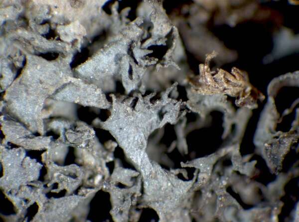
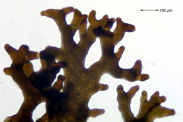
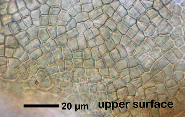
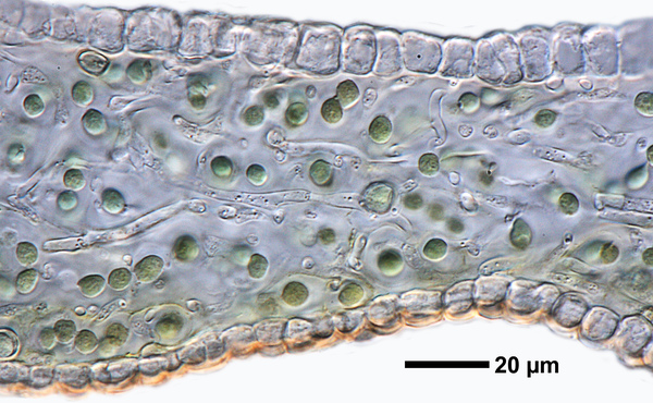
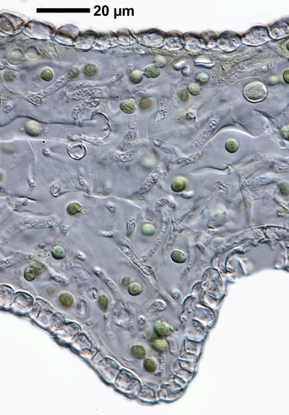
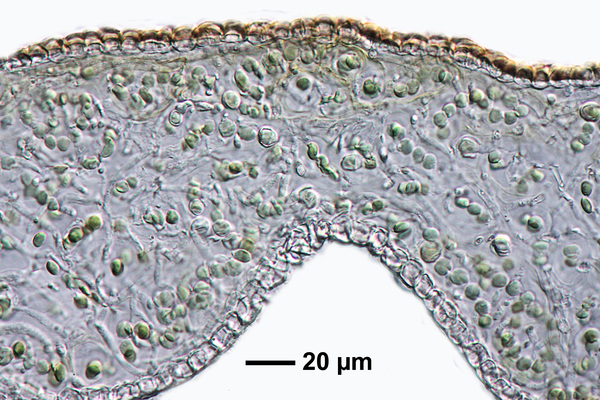
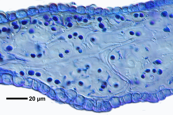
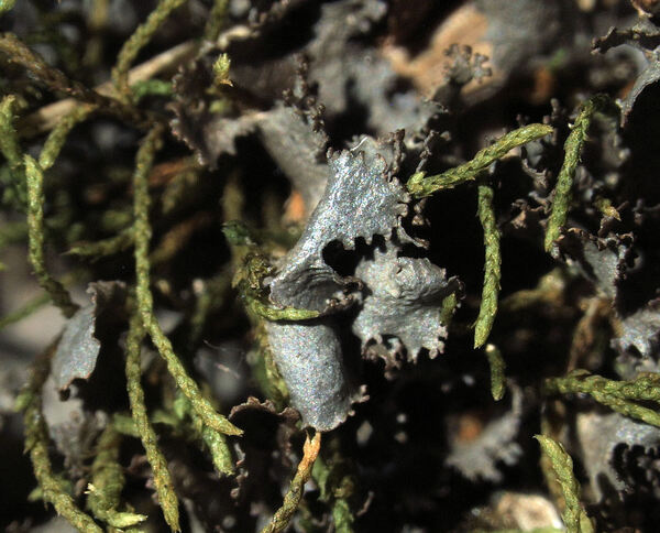
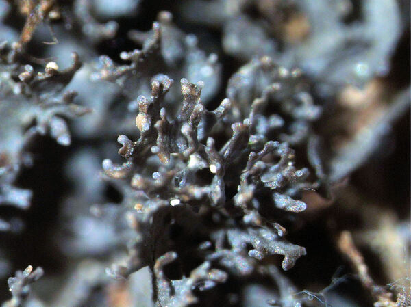
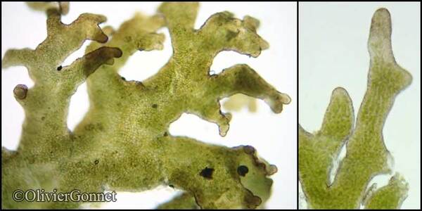
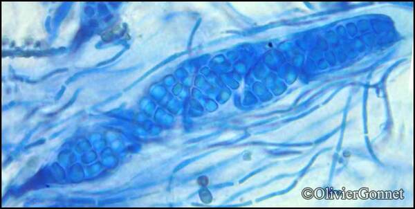
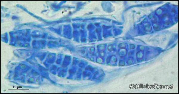
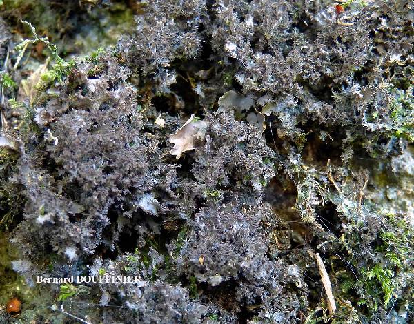
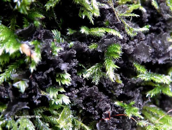
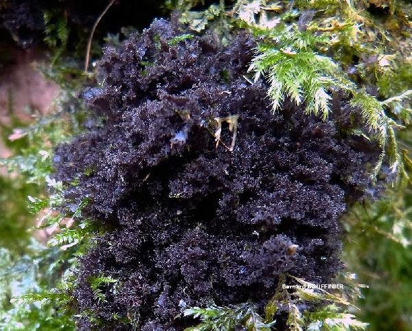
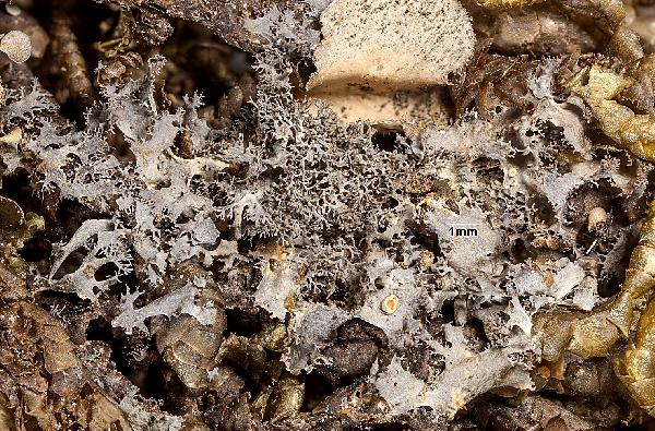
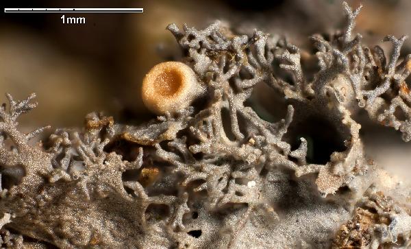
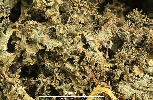
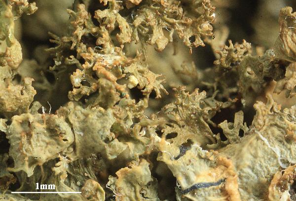
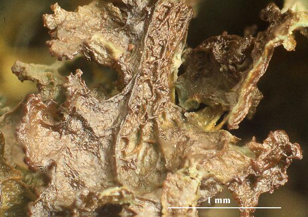
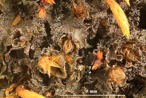
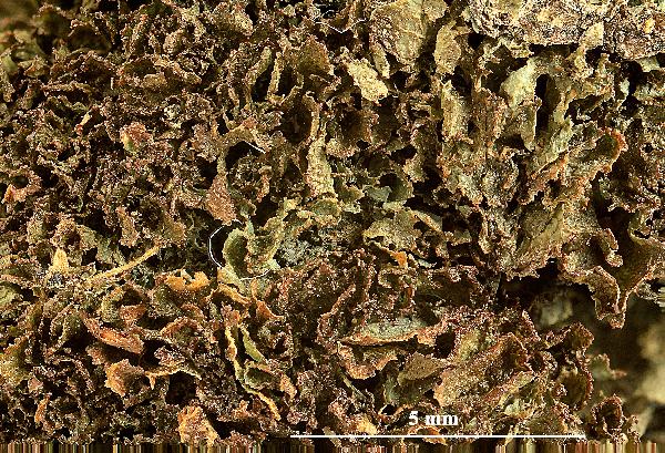
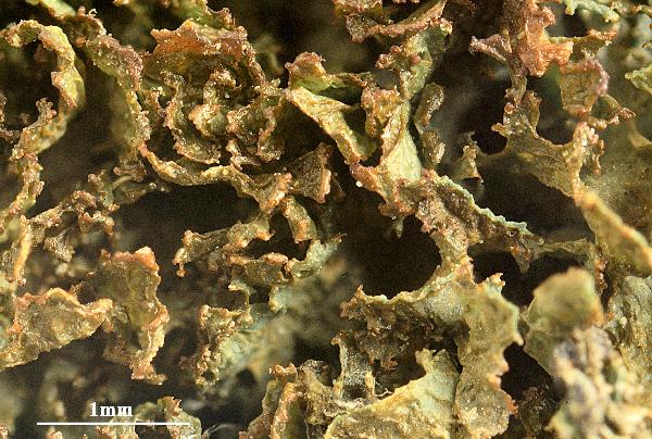
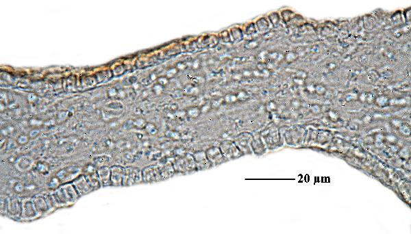
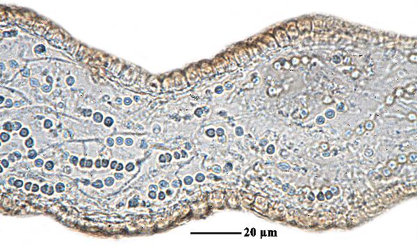
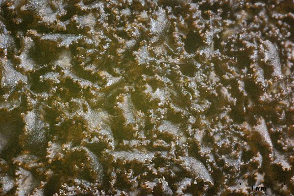
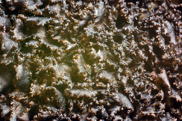
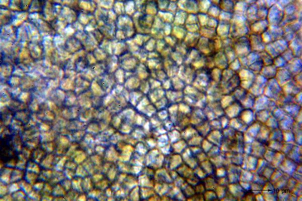
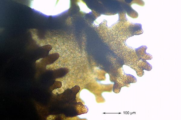
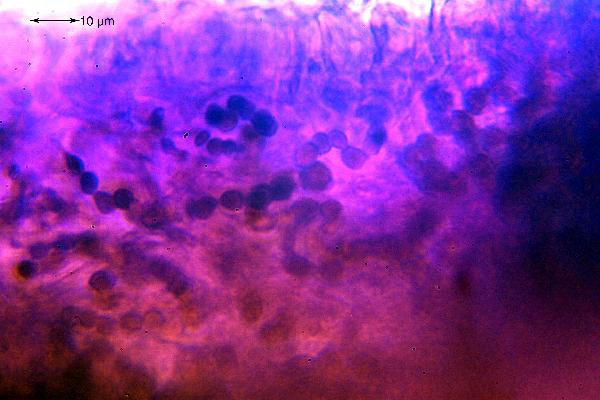
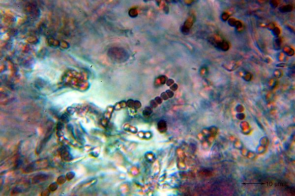
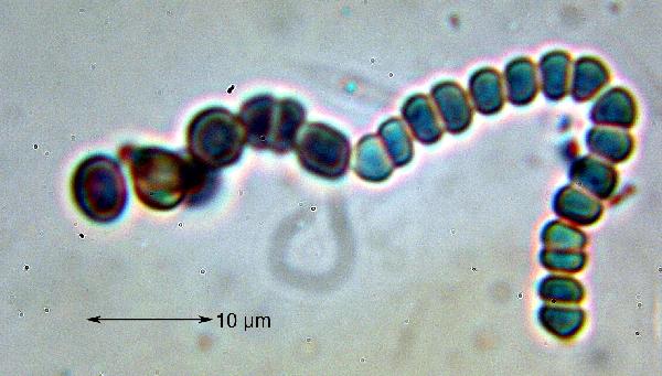
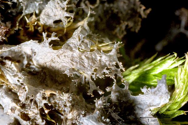
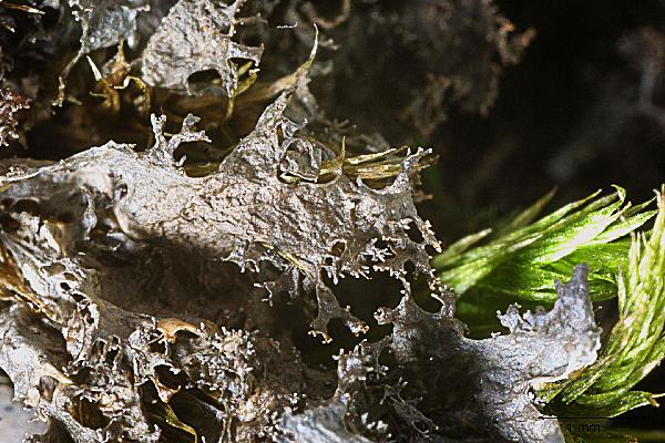
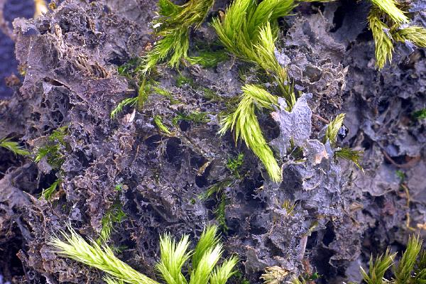
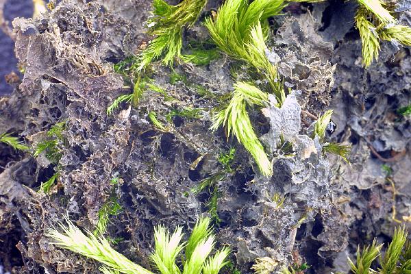
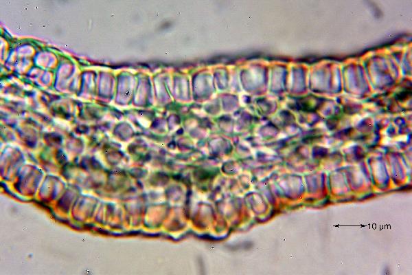
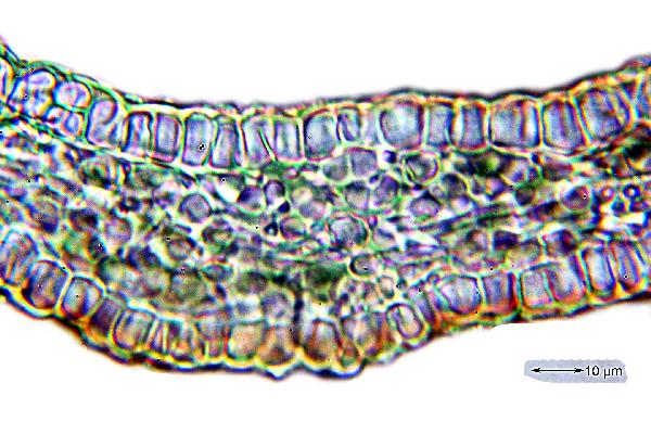
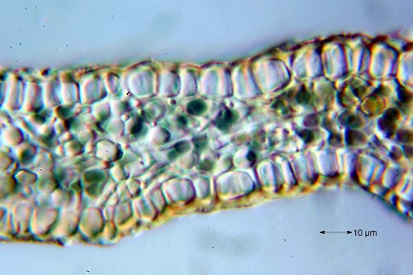
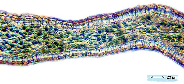
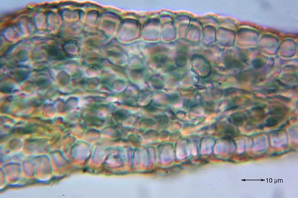
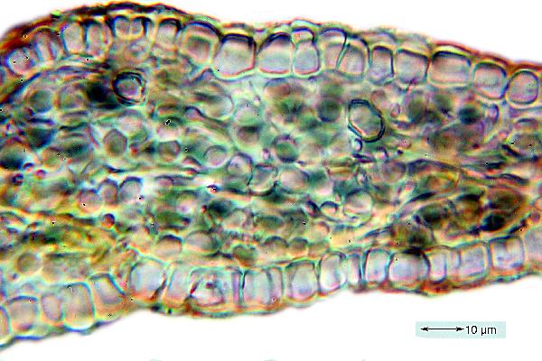
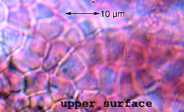
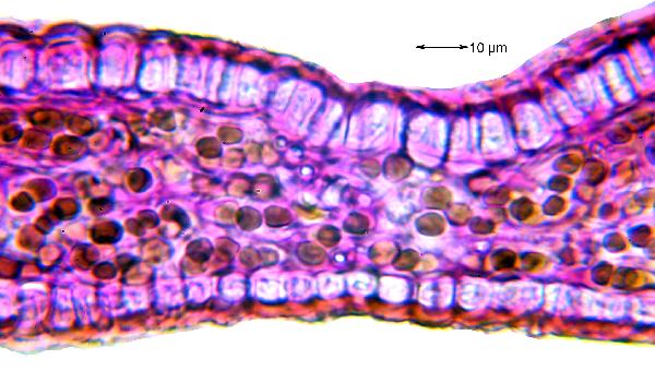
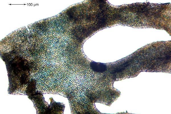
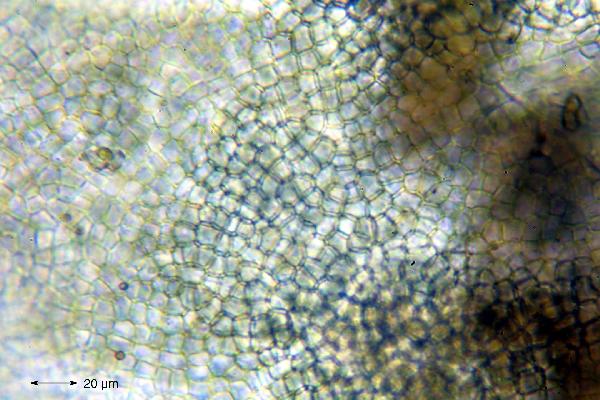
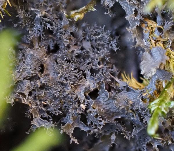
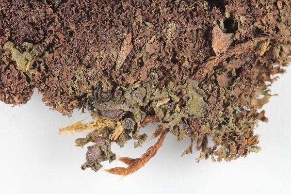
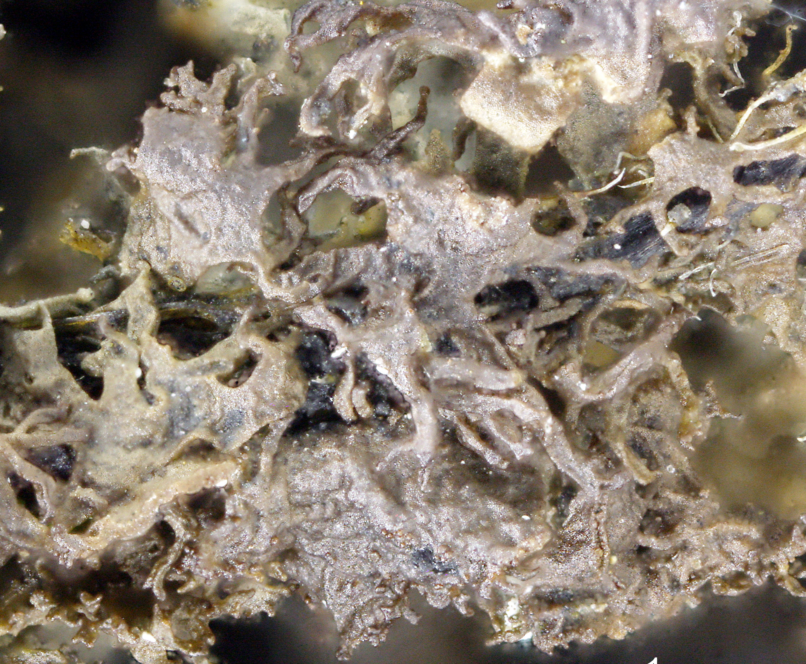
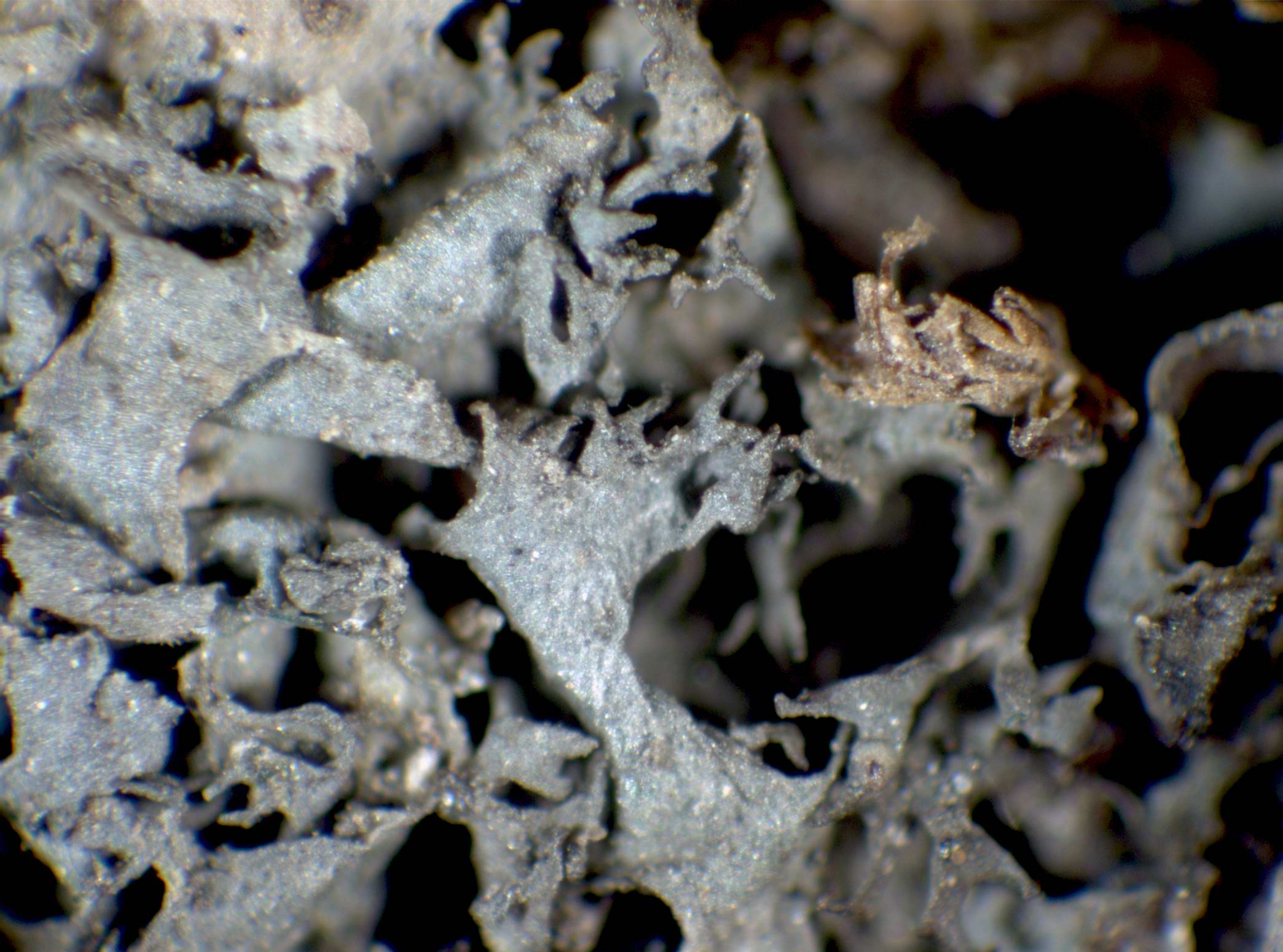
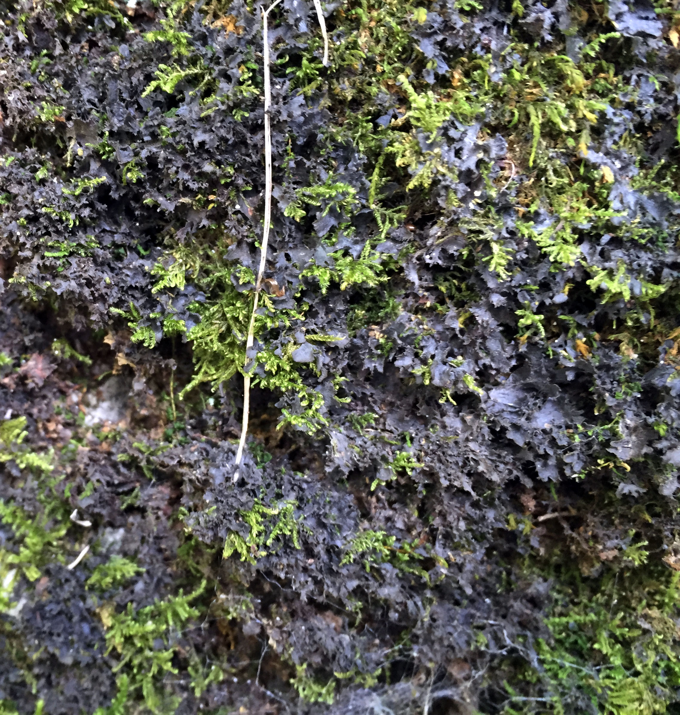
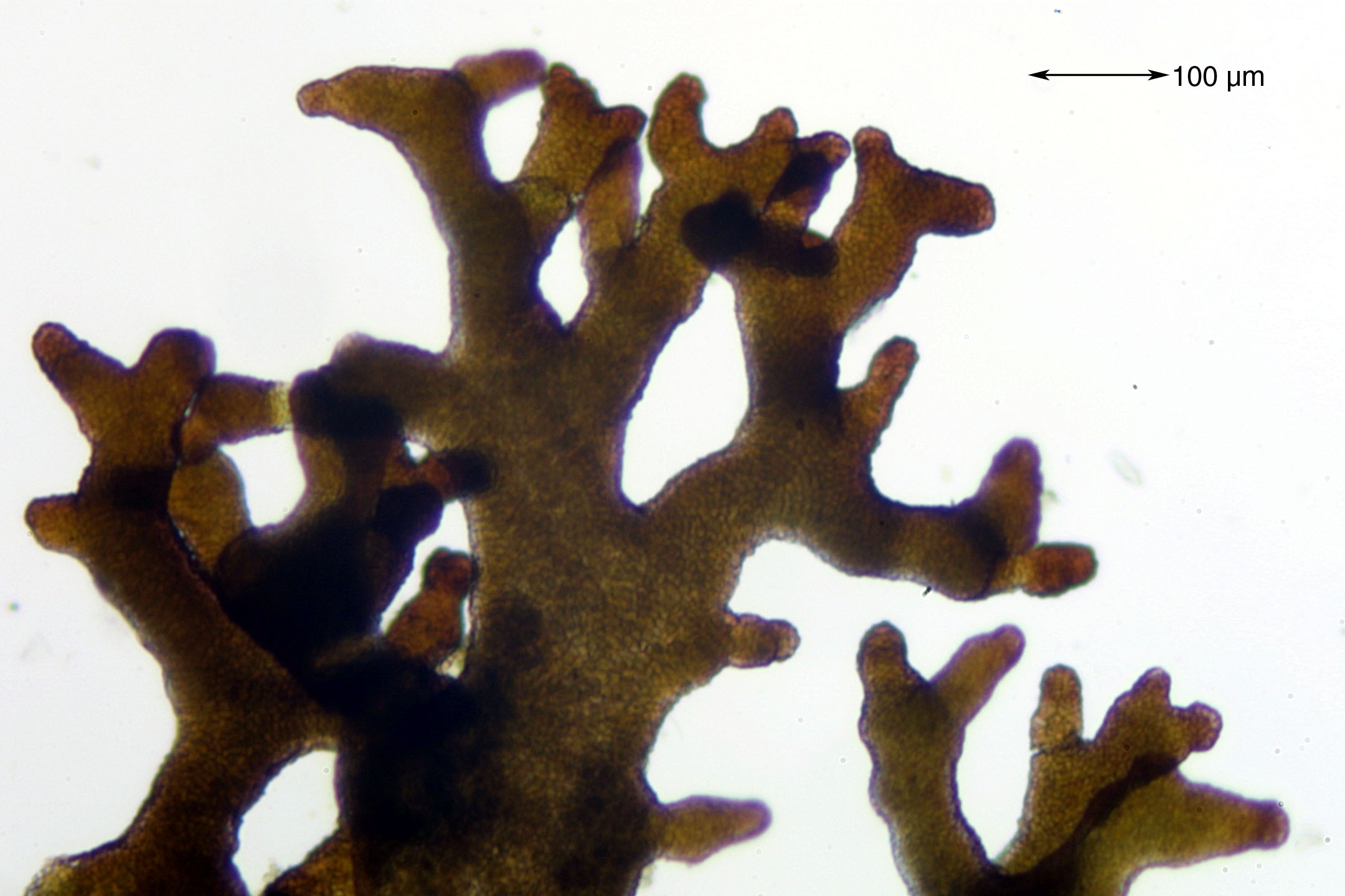
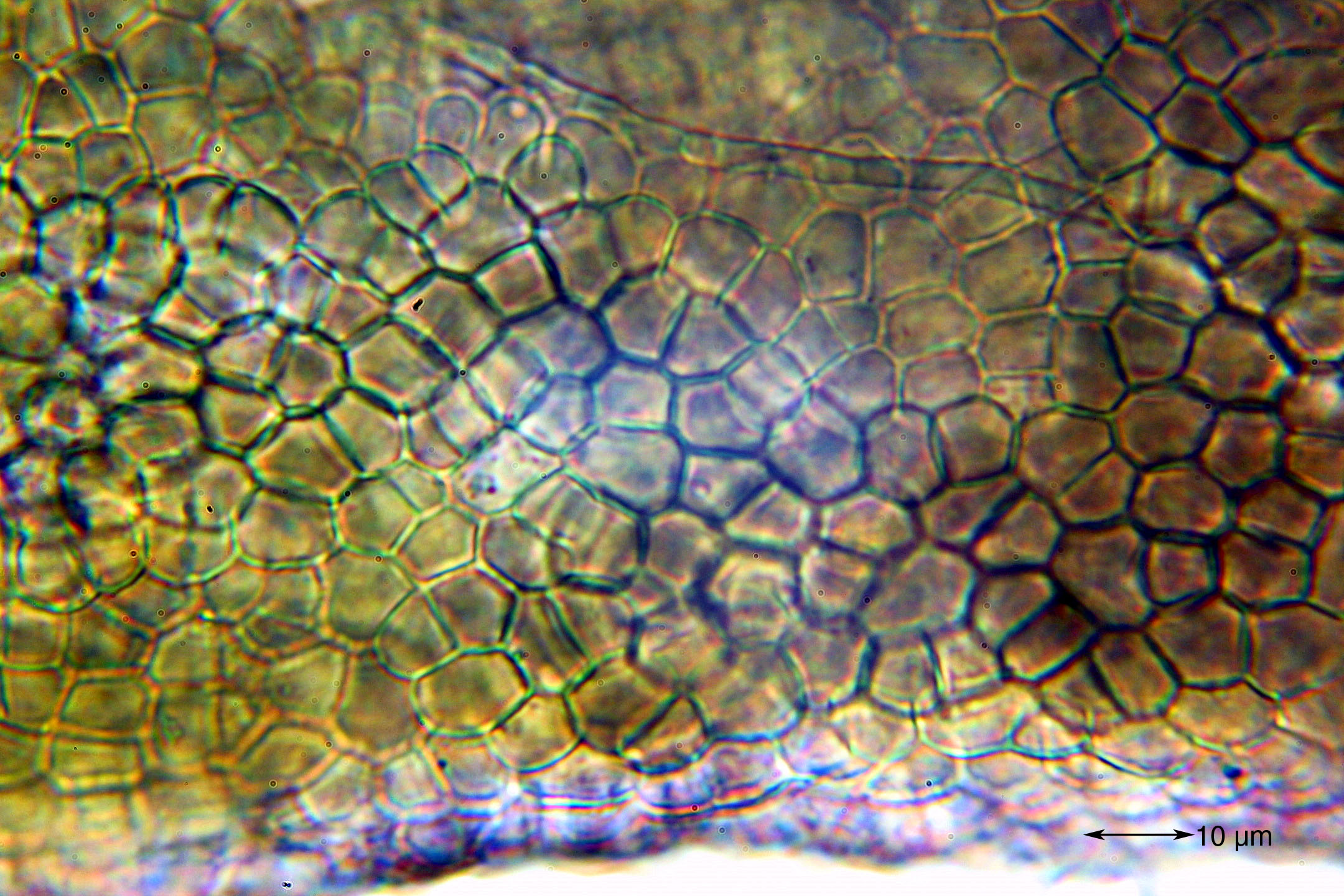
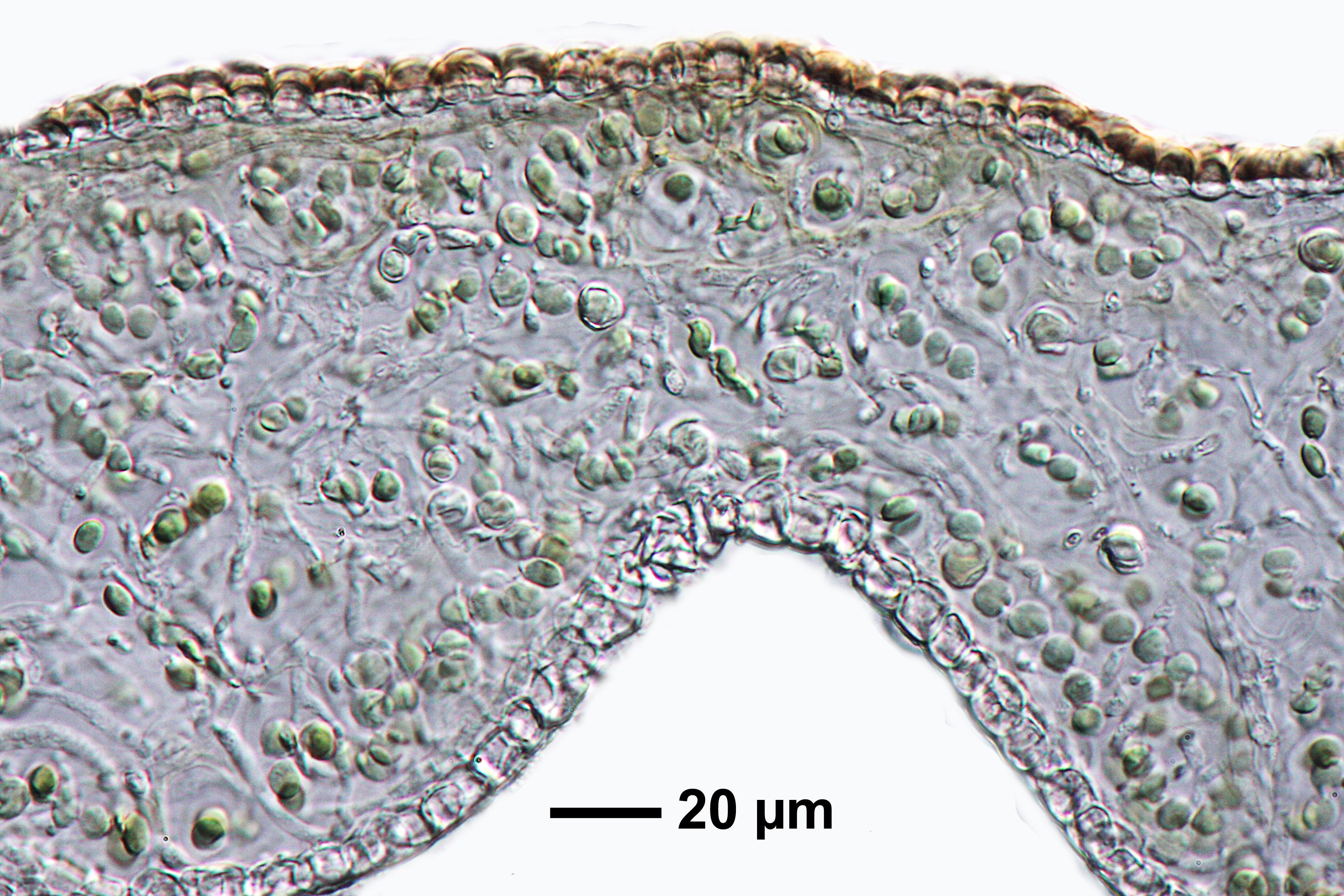
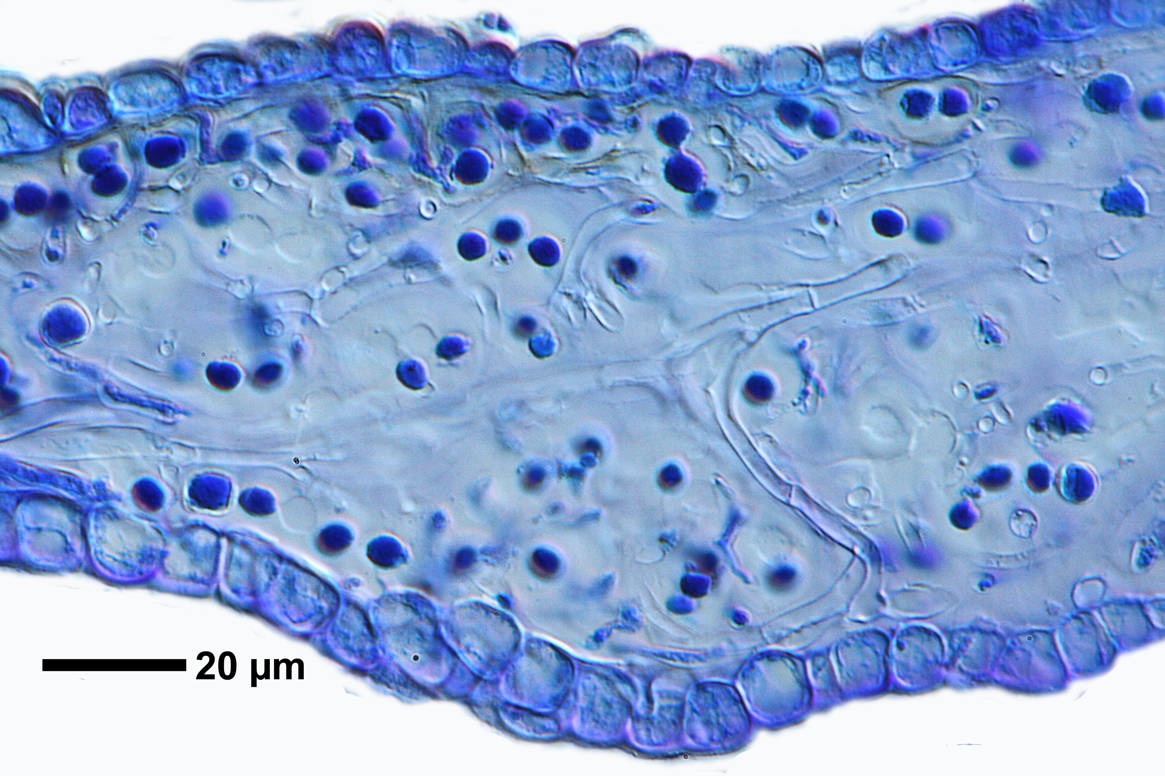
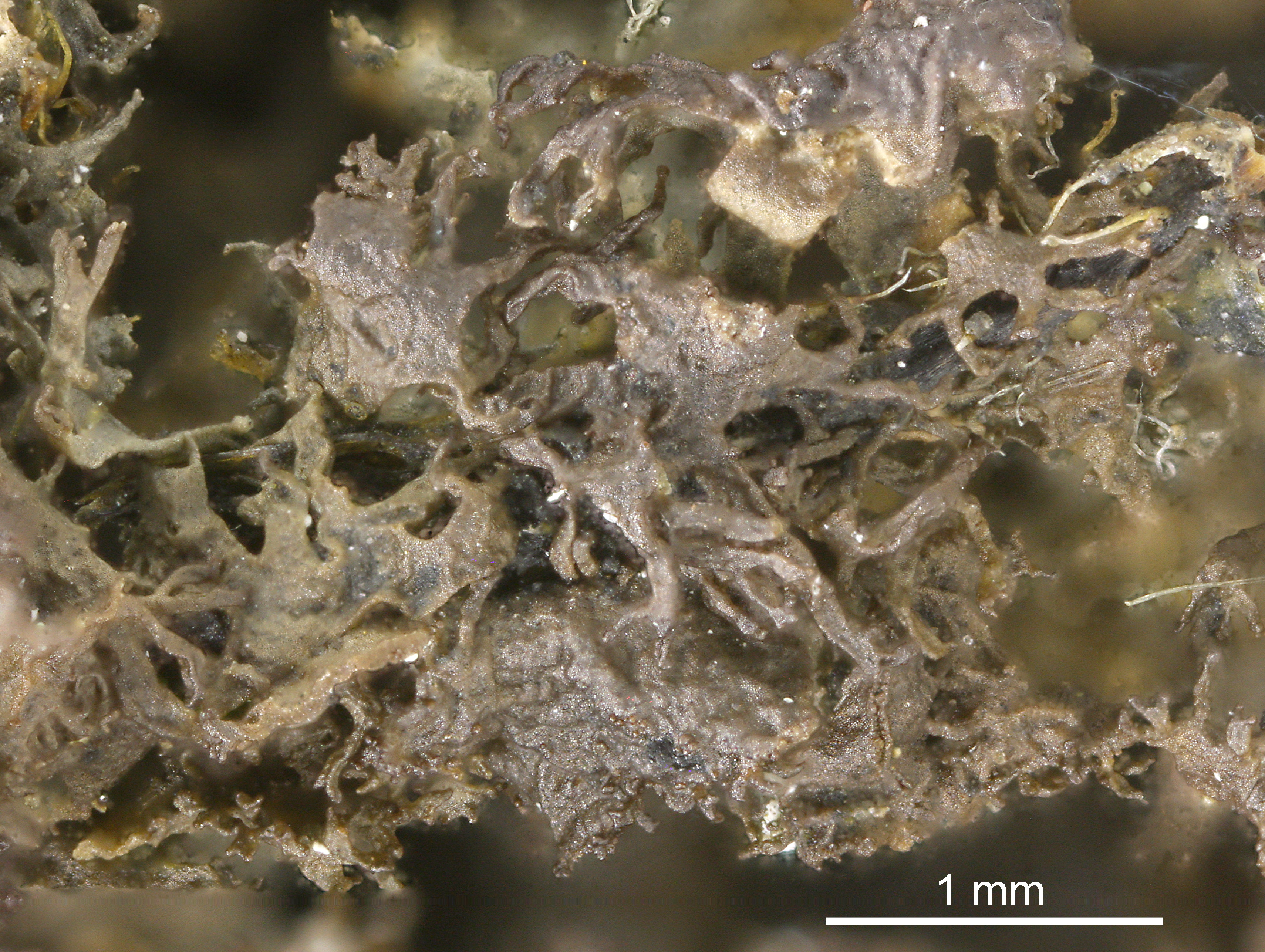
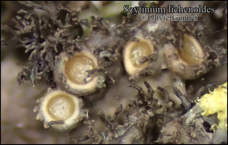
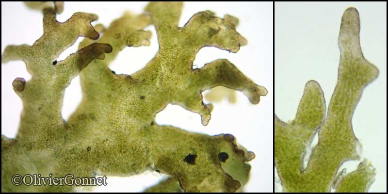
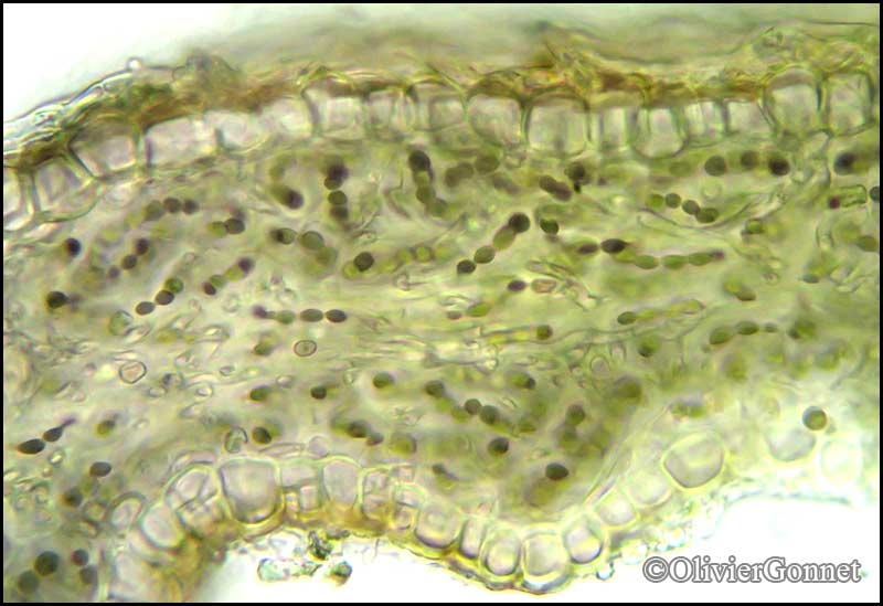
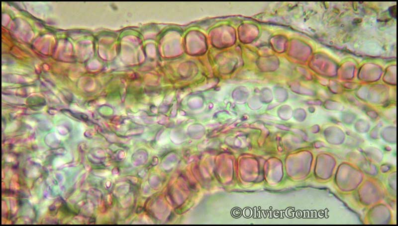
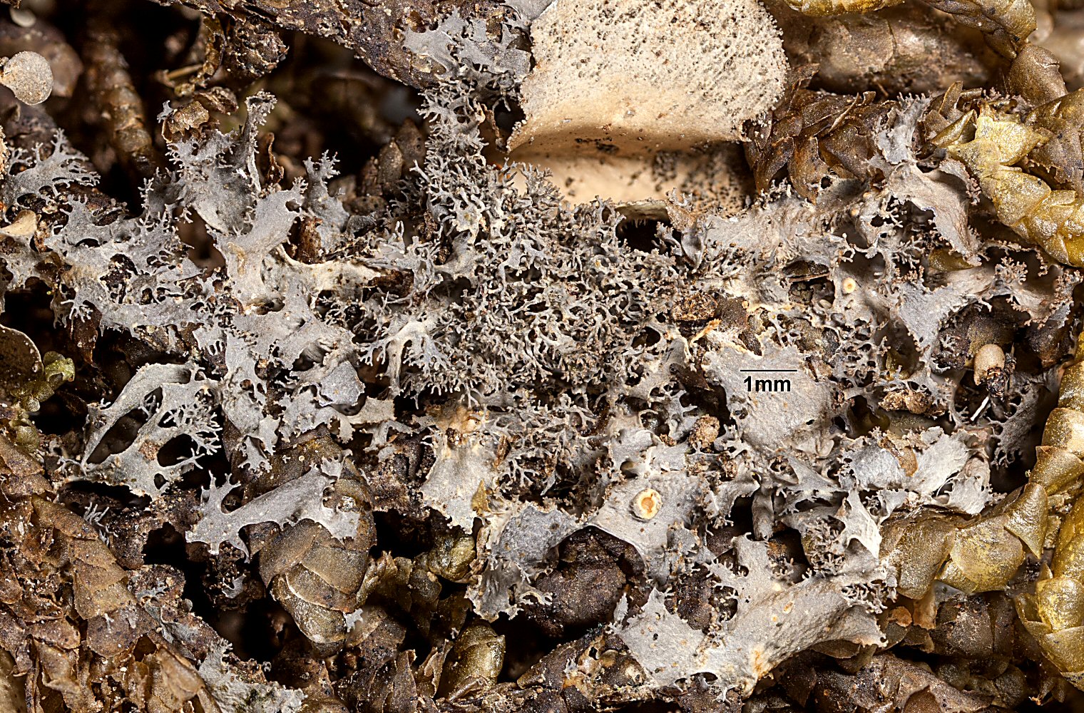
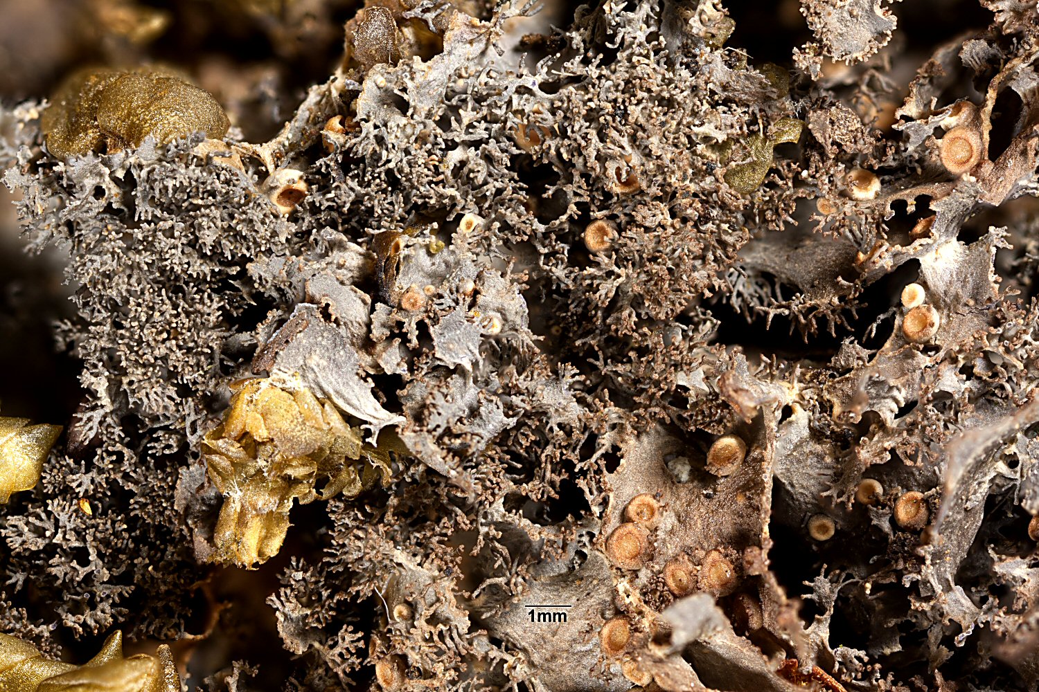
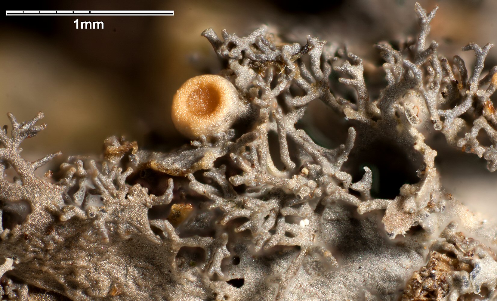
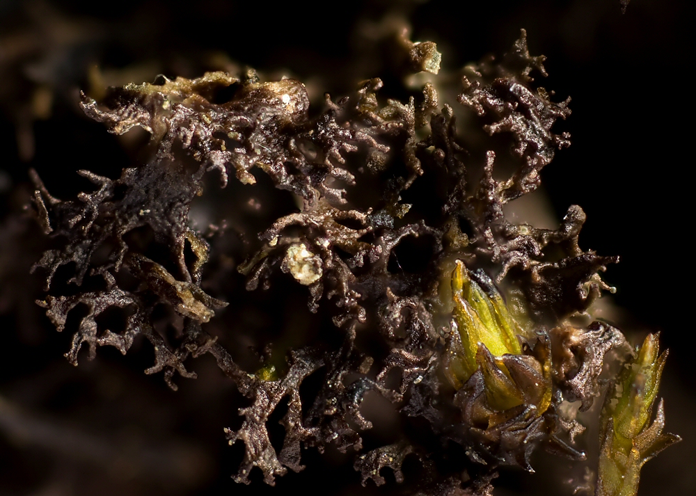
Description: Thallus minutely foliose to squamulose, slightly gelatinous when wet, of ascending, crowded lobes, often forming 2-4(-6) cm wide, very loose cushions, the lobes grey-brown to dark brown, usually somehow glossy, often paler and bluish grey in the basal, less exposed parts, thin, loosely attached, (0.3-)1-3(-4) mm broad, up to c. 1 cm long, 80-150 µm thick, ascending, more or less imbricate, the surface wrinkled, the edges deeply dilacerate-fimbriate, with cylindrical, isidia-like, often dense marginal outgrowths. Lower surface paler, erhizinate, with distinct, raised, longitudinal ribs and scattered white hapters. Upper and lower pseudocortex of 1-2 layers of angular, more or less isodiametrical cells, the layer inbetween of intertwined hyphae and loosely arranged chains of Nostoc. Apothecia rare, lecanorine, strongly constricted at base, 0.3-0.7(-1) mm across, with a brown, slightly concave to flat disc and a thalline margin often covered in coralloid outgrowths. Thalline exciple pseudocorticate; proper exciple euparaplectenchymatous, 20-70 µm wide laterally; epithecium brownish; hymenium colourless, 130-200 µm high, I+ blue; paraphyses coherent, mostly simple, 1-1.5 μm thick at mid-level, the apical cells slightly swollen; hypothecium pale yellow, 35-70 µm high. Asci 8-spored, cylindrical-clavate, the apex strongly thickened, the apical dome K/I+ pale blue, with a downwardly projecting K/I+ deep blue tubular structure. Ascospores submuriform to muriform, with 5-9 transverse septa and 1-3-longitudinal septa, thin-walled, hyaline, broadly ellipsoid to subfusiform, (20-)25-40(-50) x 11-16 μm. Photobiont cyanobacterial (Nostoc, the cells in short chains). Spot test: all negative. Chemistry: without lichen substances.
Growth form: Squamulose
Photobiont: cyanobacteria, filamentous (e.g. Nostoc, Scytonema)
Reproductive strategy: mainly sexual
Commonnes-rarity: (info)
Alpine belt: common
Subalpine belt: extremely common
Montane belt: extremely common
Dry submediterranean belt: very common
Humid submediterranean belt: very common
Padanian area: extremely rare
pH of the substrata:
1 2 3 4 5

Solar irradiation:
1 2 3 4 5
Aridity:
1 2 3 4 5
Eutrophication:
1 2 3 4 5
Poleotolerance:
0 1 2 3
Altitudinal distribution:
1 2 3 4 5 6
Rarity
absent
extremely rare
very rare
rare
rather rare
rather common
common
very common
extremely common
Loading data...
Occurrence data
Predictive map
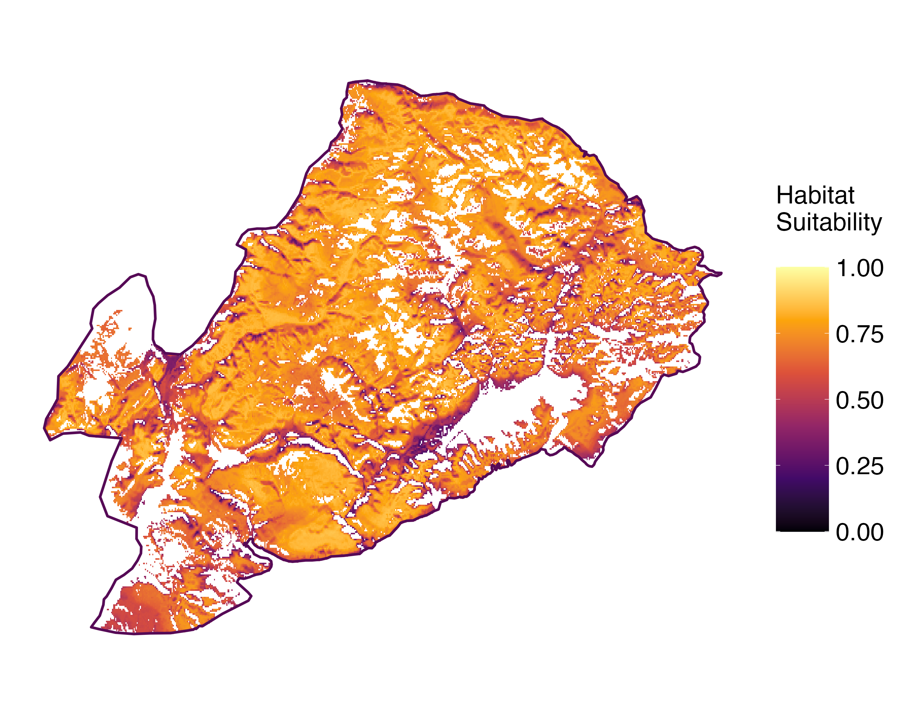 Current prediction (1981-2010)
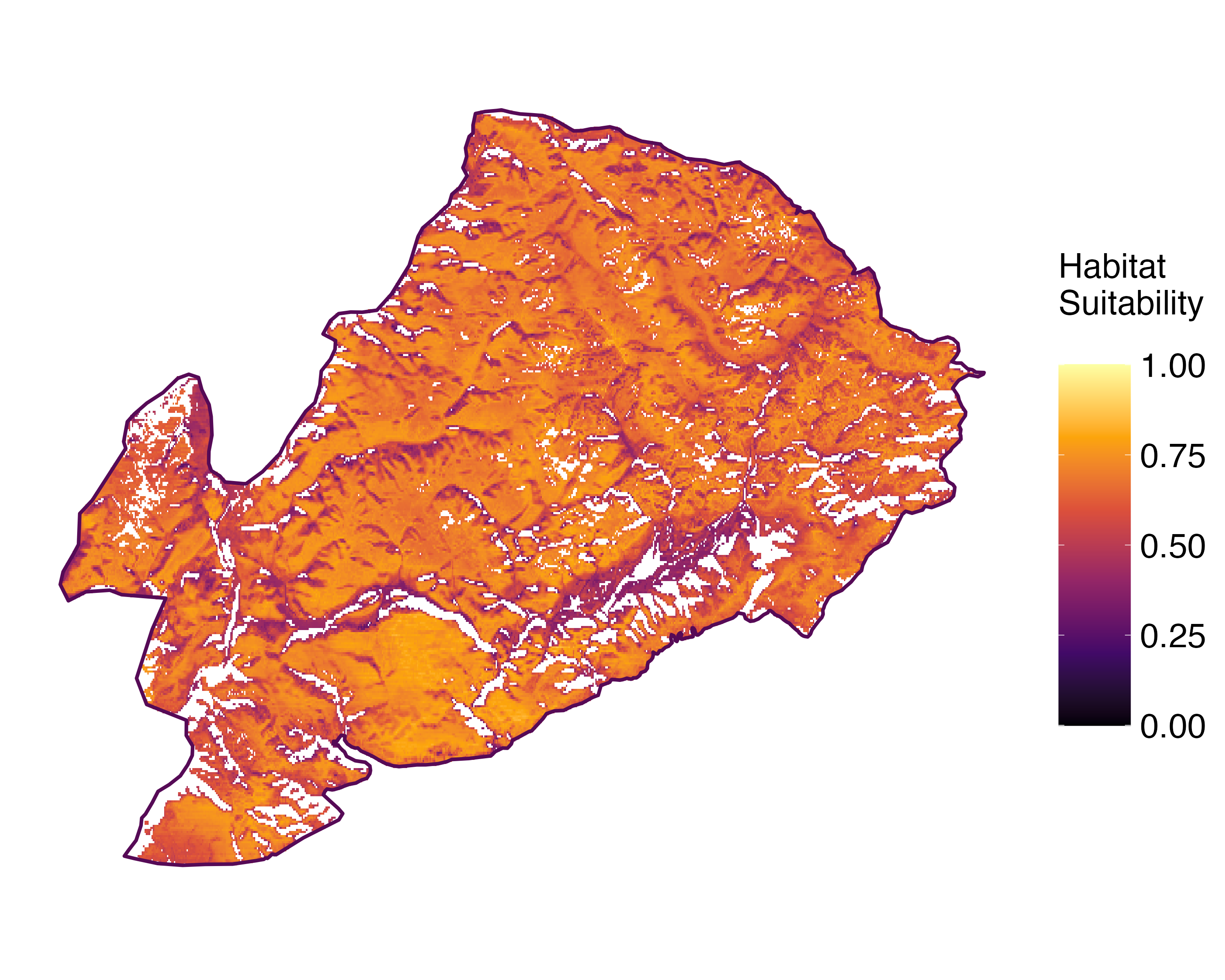 Future prediction (2071-2100) SSP 1-2.6
 Future prediction (2071-2100) SSP 5-8.5Predictive maps according to Francesconi et al. 2025
Felix Schumm CC BY-SA 4.0
[16507], Germany, Baden-Württemberg, Kreis Göppingen, Gosbach- Bad Ditzenbach, Tierstein, 48,57461° N, 9,68471° E, 737 m, auf Kalkfelsen am Albrand. Leg. et det. Schumm 20.06.2010.
P.L. Nimis; Owner: Department of Life Sciences, University of Trieste
Herbarium: TSB (5234)
2001/11/26

P.L. Nimis; Owner: Department of Life Sciences, University of Trieste
Italy, Friuli Venezia Giulia, Udine, Ampezzo Carnico, 650 m
09.09.2016
Felix Schumm - CC BY-SA 4.0
[12319], Griechenland, N-Samos, südlich Avlakia an der Straße nach Vourliotes, 37°48'N, 26°51'E, 163 m; schattige Straßenböschung mit Quercus ilex, Arbutus andrachne u. Styrax-Vegetation. Leg. Schumm, Düll & Maier 03.05.2006, det Schumm 2006.
Felix Schumm - CC BY-SA 4.0
[12319], Griechenland, N-Samos, südlich Avlakia an der Straße nach Vourliotes, 37°48'N, 26°51'E, 163 m; schattige Straßenböschung mit Quercus ilex, Arbutus andrachne u. Styrax-Vegetation. Leg. Schumm, Düll & Maier 03.05.2006, det Schumm 2006.

Felix Schumm - CC BY-SA 4.0
[12319], Griechenland, N-Samos, südlich Avlakia an der Straße nach Vourliotes, 37°48'N, 26°51'E, 163 m; schattige Straßenböschung mit Quercus ilex, Arbutus andrachne u. Styrax-Vegetation. Leg. Schumm, Düll & Maier 03.05.2006, det Schumm 2006.

Felix Schumm - CC BY-SA 4.0
[12319], Griechenland, N-Samos, südlich Avlakia an der Straße nach Vourliotes, 37°48'N, 26°51'E, 163 m; schattige Straßenböschung mit Quercus ilex, Arbutus andrachne u. Styrax-Vegetation. Leg. Schumm, Düll & Maier 03.05.2006, det Schumm 2006.
Felix Schumm - CC BY-SA 4.0
[12319], Griechenland, N-Samos, südlich Avlakia an der Straße nach Vourliotes, 37°48'N, 26°51'E, 163 m; schattige Straßenböschung mit Quercus ilex, Arbutus andrachne u. Styrax-Vegetation. Leg. Schumm, Düll & Maier 03.05.2006, det Schumm 2006.
Felix Schumm - CC BY-SA 4.0
[16507], Germany, Baden-Württemberg, Kreis Göppingen, Gosbach- Bad Ditzenbach, Tierstein, 48,57461° N, 9,68471° E, 737 m, auf Kalkfelsen am Albrand. Leg. et det. Schumm 20.06.2010.
Felix Schumm - CC BY-SA 4.0
[16507], Germany, Baden-Württemberg, Kreis Göppingen, Gosbach- Bad Ditzenbach, Tierstein, 48,57461° N, 9,68471° E, 737 m, auf Kalkfelsen am Albrand. Leg. et det. Schumm 20.06.2010.
Felix Schumm - CC BY-SA 4.0
[16507], Germany, Baden-Württemberg, Kreis Göppingen, Gosbach- Bad Ditzenbach, Tierstein, 48,57461° N, 9,68471° E, 737 m, auf Kalkfelsen am Albrand. Leg. et det. Schumm 20.06.2010.
Felix Schumm - CC BY-SA 4.0
[16507], Germany, Baden-Württemberg, Kreis Göppingen, Gosbach- Bad Ditzenbach, Tierstein, 48,57461° N, 9,68471° E, 737 m, auf Kalkfelsen am Albrand. Leg. et det. Schumm 20.06.2010.
Felix Schumm - CC BY-SA 4.0
[16507], Germany, Baden-Württemberg, Kreis Göppingen, Gosbach- Bad Ditzenbach, Tierstein, 48,57461° N, 9,68471° E, 737 m, auf Kalkfelsen am Albrand. Leg. et det. Schumm 20.06.2010.
Felix Schumm - CC BY-SA 4.0
[16507], Germany, Baden-Württemberg, Kreis Göppingen, Gosbach- Bad Ditzenbach, Tierstein, 48,57461° N, 9,68471° E, 737 m, auf Kalkfelsen am Albrand. Leg. et det. Schumm 20.06.2010.
P.L. Nimis CC BY-SA 4.0
TSB 37971
P.L. Nimis CC BY-SA 4.0
TSB 37971

Felix Schumm - CC BY-SA 4.0
[16507], Germany, Baden-Württemberg, Kreis Göppingen, Gosbach- Bad Ditzenbach, Tierstein, 48,57461° N, 9,68471° E, 737 m, auf Kalkfelsen am Albrand. Leg. et det. Schumm 20.06.2010.

Courtesy Danièle et Olivier Gonnet - Source: https://www.afl-lichenologie.fr/Photos_AFL/Photos_AFL_S/Text_S/Scytinium_lichenoides.htm
France, 31/3/2011 - Mont d'Or
Courtesy Danièle et Olivier Gonnet - Source: https://www.afl-lichenologie.fr/Photos_AFL/Photos_AFL_S/Text_S/Scytinium_lichenoides.htm
France, 31/3/2011 - Mont d'Or

Courtesy Danièle et Olivier Gonnet - Source: https://www.afl-lichenologie.fr/Photos_AFL/Photos_AFL_S/Text_S/Scytinium_lichenoides.htm
France, 31/3/2011 - Mont d'Or

Courtesy Danièle et Olivier Gonnet - Source: https://www.afl-lichenologie.fr/Photos_AFL/Photos_AFL_S/Text_S/Scytinium_lichenoides.htm
France, 31/3/2011 - Mont d'Or
Courtesy Danièle et Olivier Gonnet - Source: https://www.afl-lichenologie.fr/Photos_AFL/Photos_AFL_S/Text_S/Scytinium_lichenoides.htm
France, 31/3/2011 - Mont d'Or
Courtesy Danièle et Olivier Gonnet - Source: https://www.afl-lichenologie.fr/Photos_AFL/Photos_AFL_S/Text_S/Scytinium_lichenoides.htm
France, 31/3/2011 - Mont d'Or

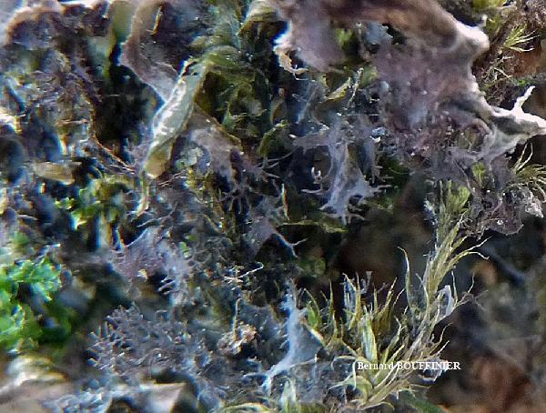
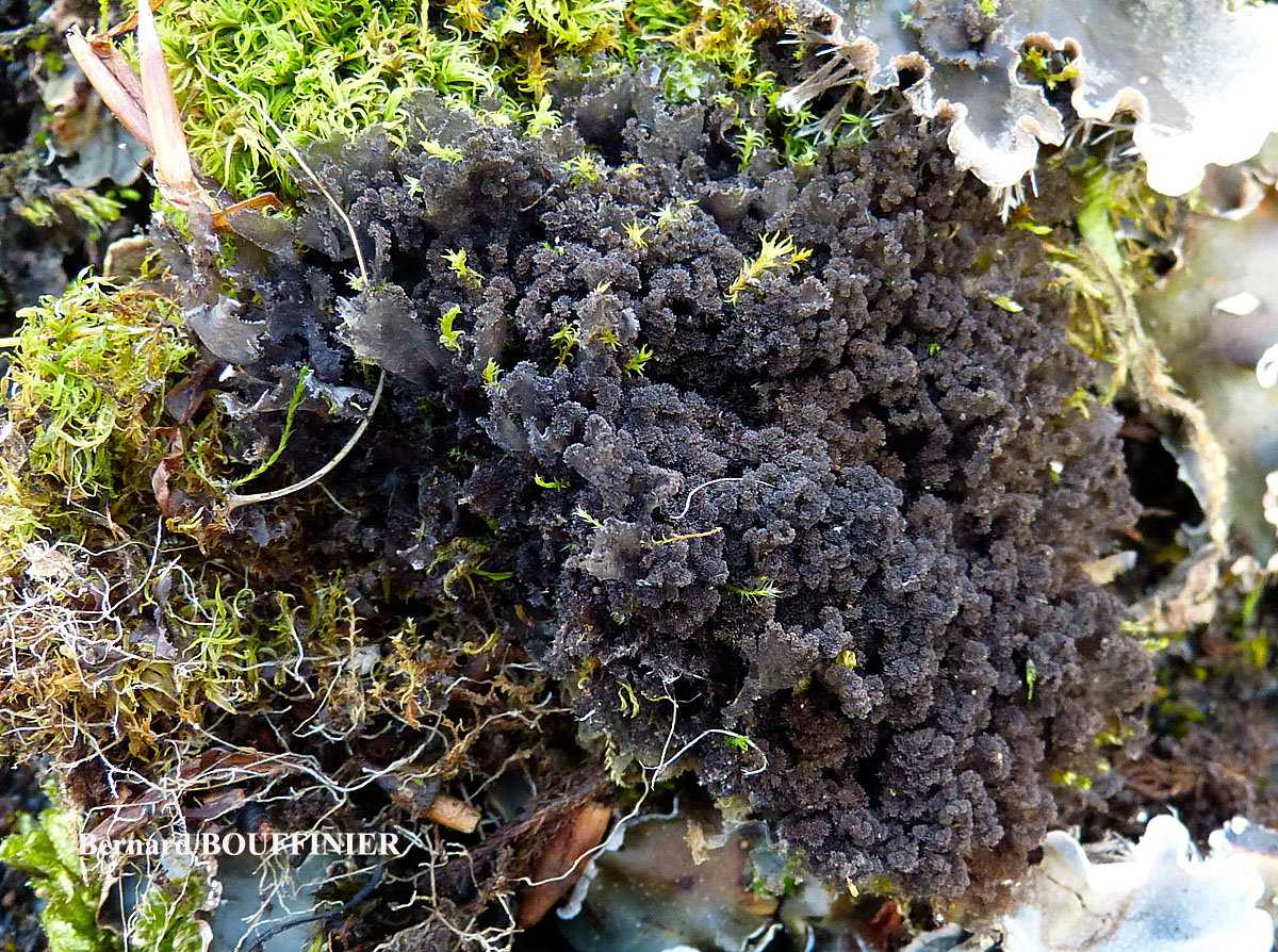
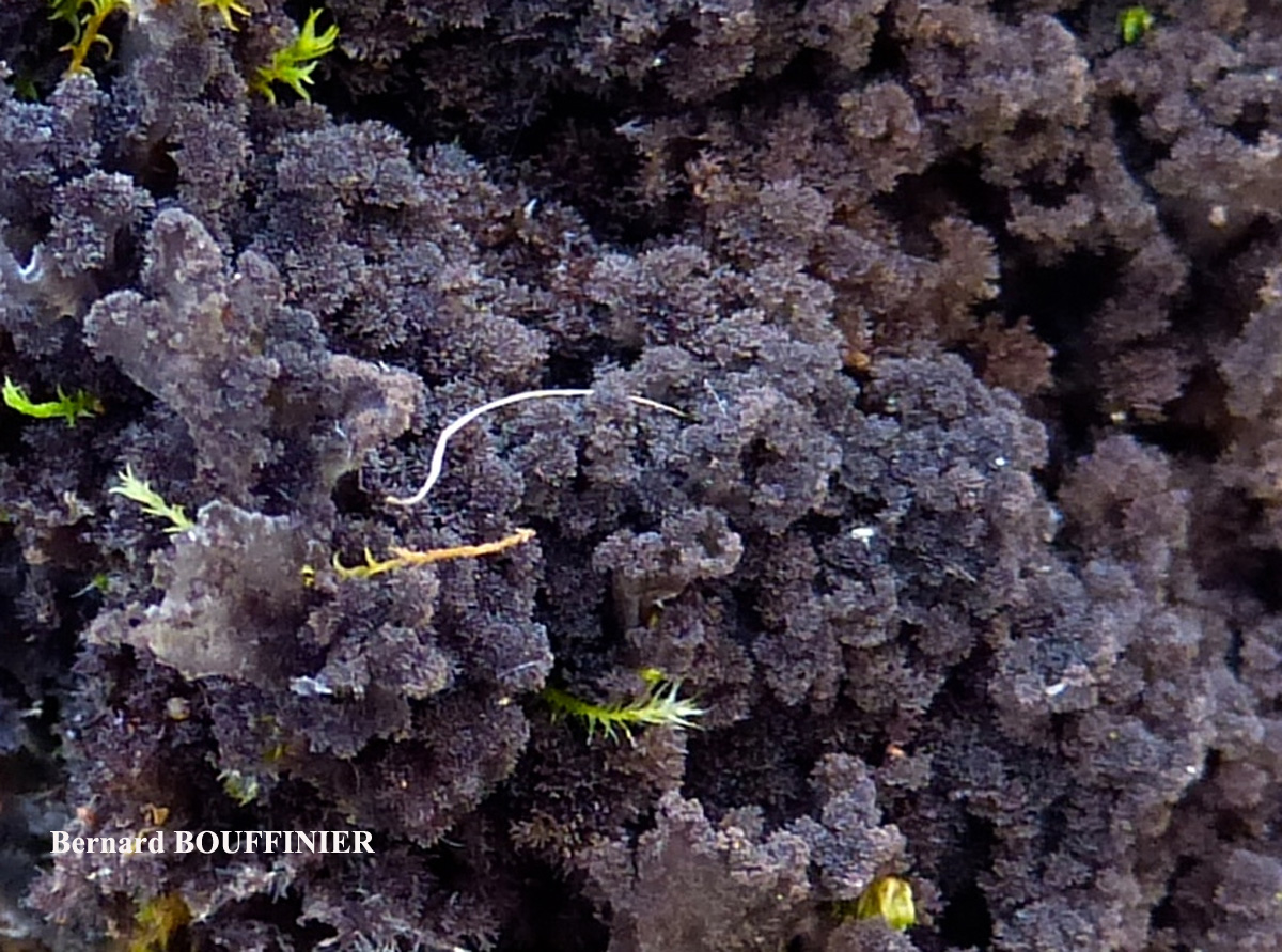
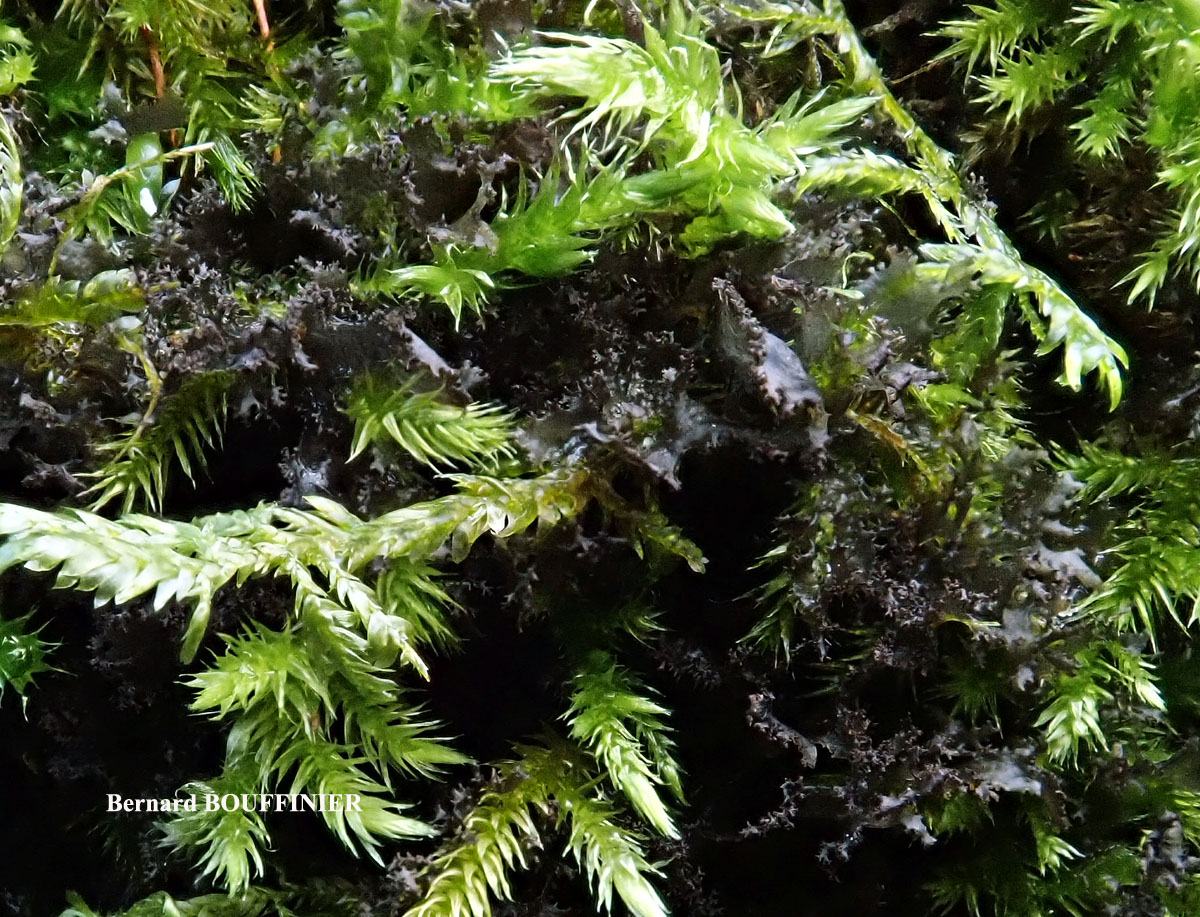
Bernard Bouffinier - Source: http://www.lichensmaritimes.org/index.php?task=fiche&lichen=342&lang=en
France, Barrage du Tech

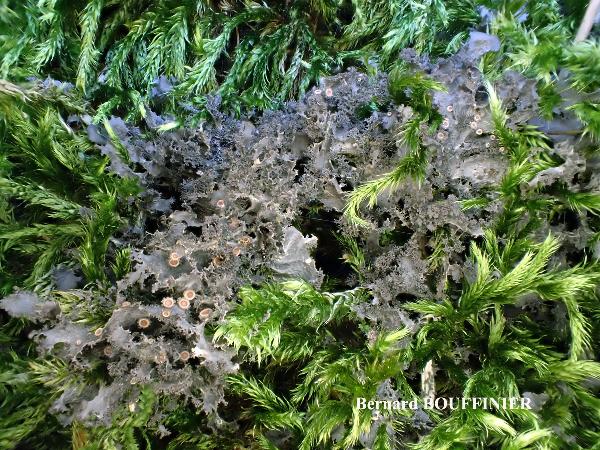
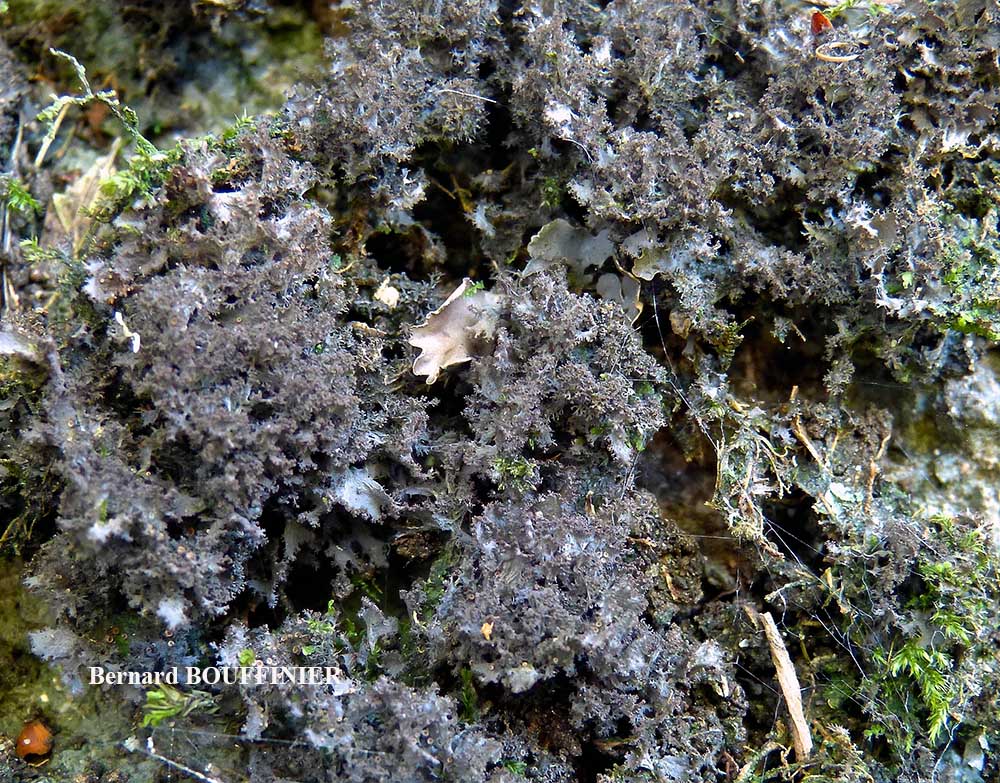
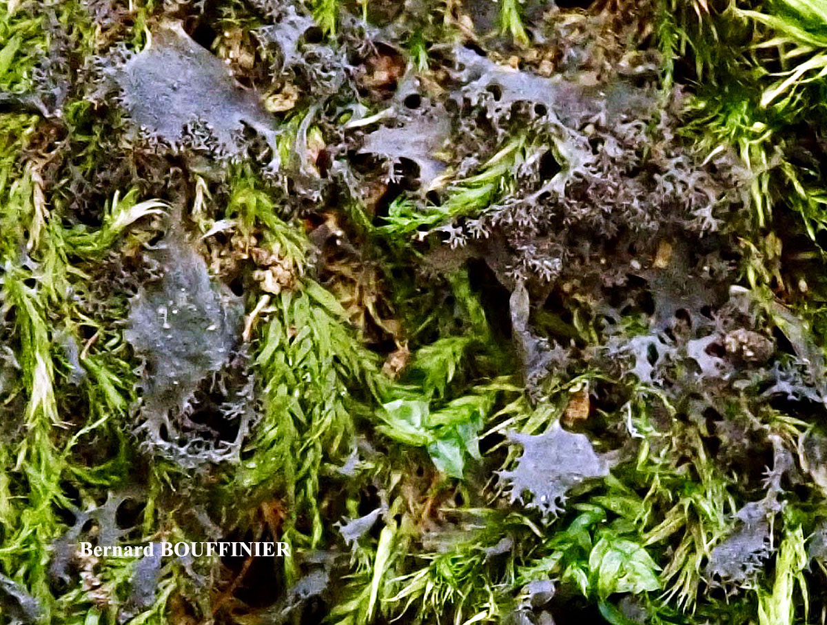
Bernard Bouffinier - Source: http://www.lichensmaritimes.org/index.php?task=fiche&lichen=342&lang=en
France, Barrage du Tech
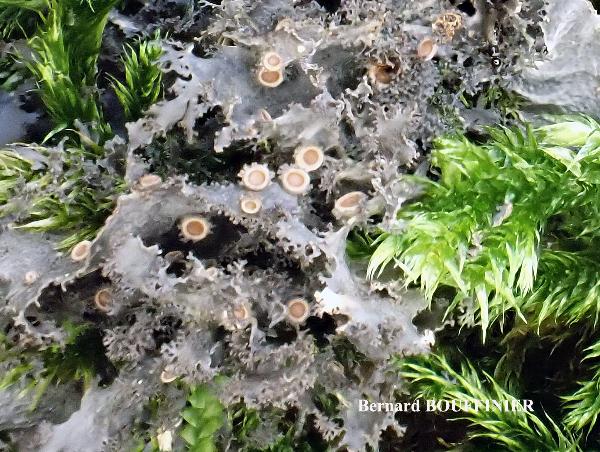
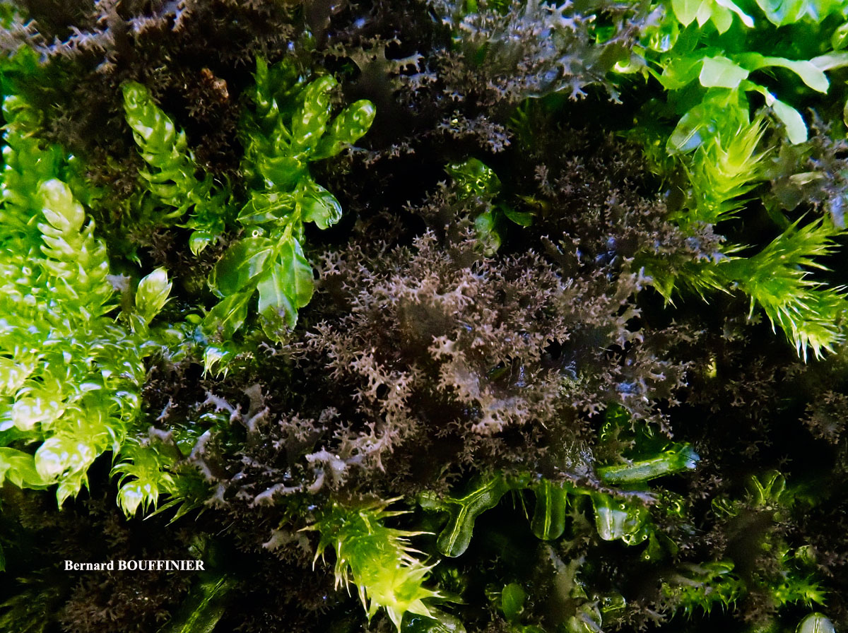
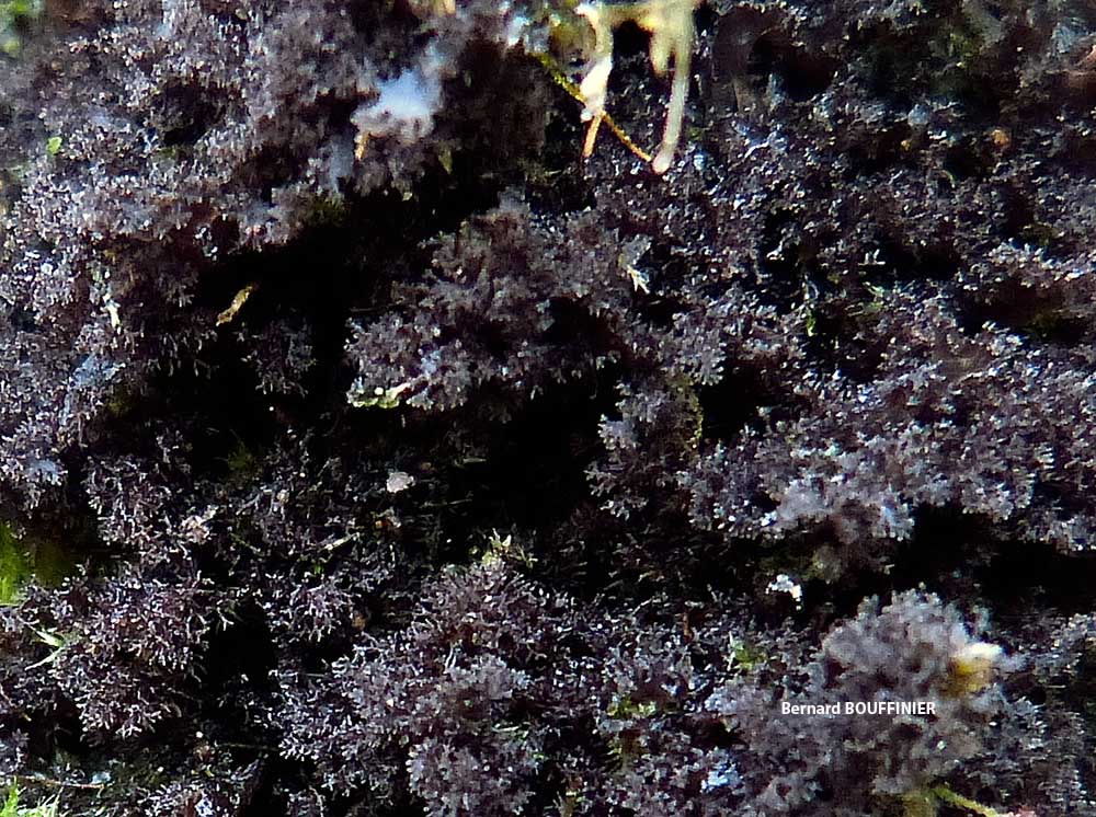
Bernard Bouffinier - Source: http://www.lichensmaritimes.org/index.php?task=fiche&lichen=342&lang=en
France, Le Faouet

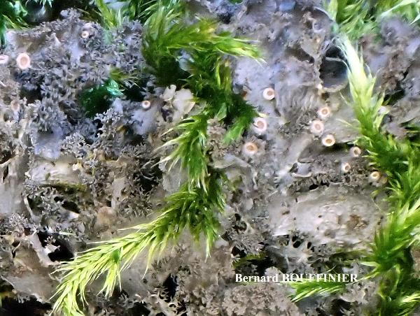
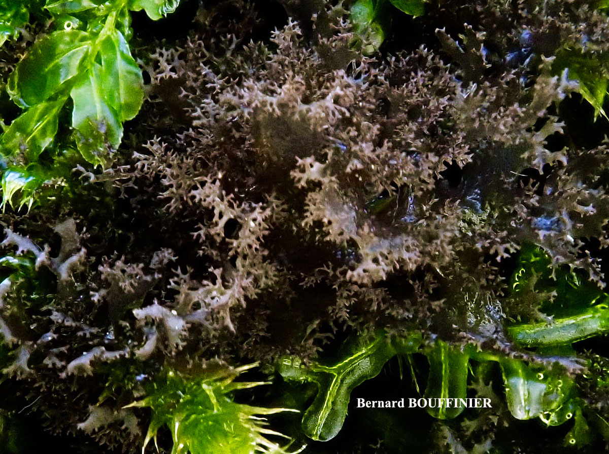
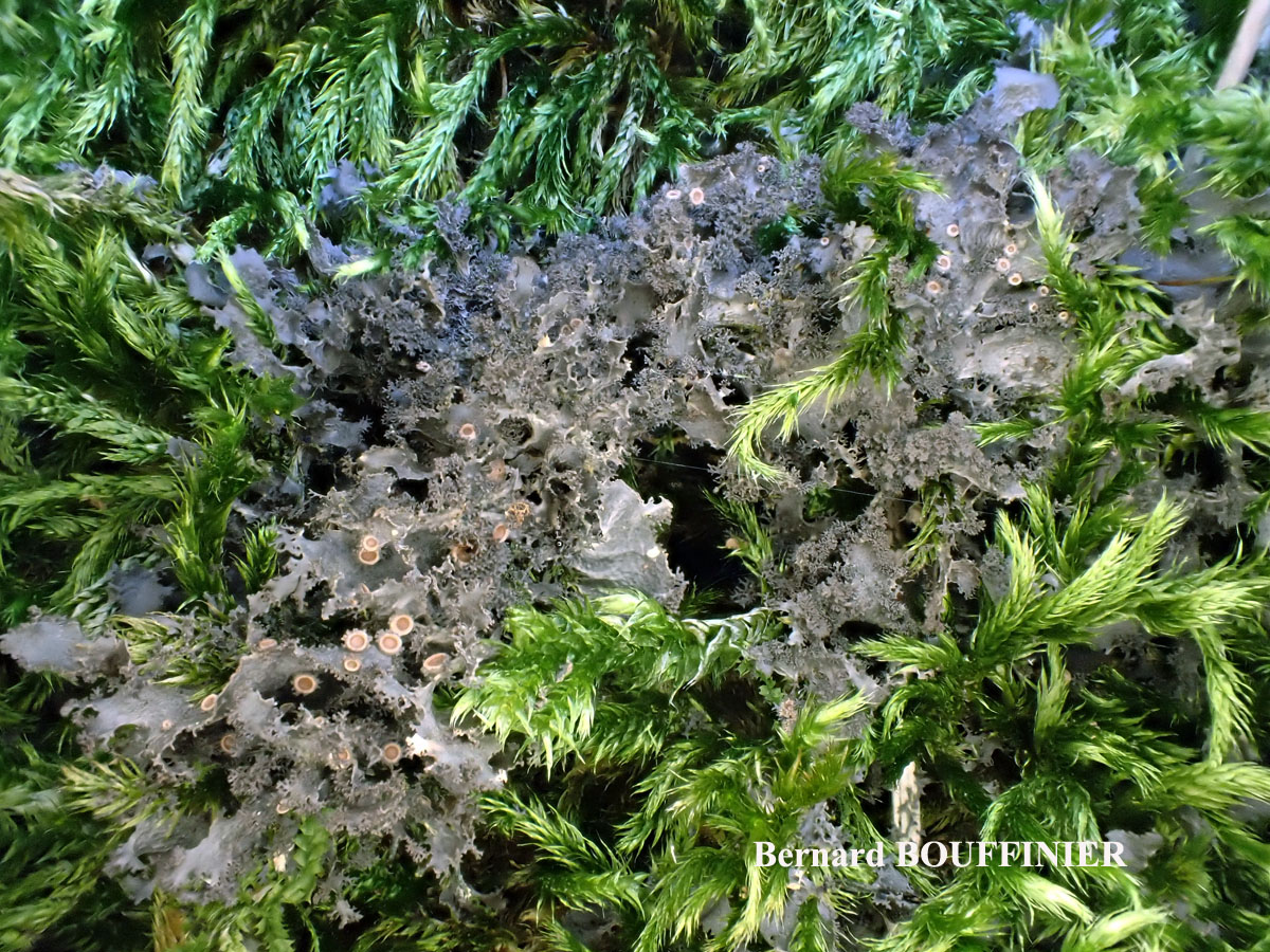
Bernard Bouffinier - Source: http://www.lichensmaritimes.org/index.php?task=fiche&lichen=342&lang=en
France, Dineault

Bernard Bouffinier - Source: http://www.lichensmaritimes.org/index.php?task=fiche&lichen=342&lang=en
France, Dineault

Bernard Bouffinier - Source: http://www.lichensmaritimes.org/index.php?task=fiche&lichen=342&lang=en
France, Dineault

Bernard Bouffinier - Source: http://www.lichensmaritimes.org/index.php?task=fiche&lichen=342&lang=en
France, Dineault
Bernard Bouffinier - Source: http://www.lichensmaritimes.org/index.php?task=fiche&lichen=342&lang=en
France, Saint Herbot
Bernard Bouffinier - Source: http://www.lichensmaritimes.org/index.php?task=fiche&lichen=342&lang=en
France, Saint Herbot

Bernard Bouffinier - Source: http://www.lichensmaritimes.org/index.php?task=fiche&lichen=342&lang=en
France, Saint Herbot
Bernard Bouffinier - Source: http://www.lichensmaritimes.org/index.php?task=fiche&lichen=342&lang=en
France, Tregarvan
Bernard Bouffinier - Source: http://www.lichensmaritimes.org/index.php?task=fiche&lichen=342&lang=en
France, Fontenay Le Comte
Bernard Bouffinier - Source: http://www.lichensmaritimes.org/index.php?task=fiche&lichen=342&lang=en
France, Fontenay Le Comte
Bernard Bouffinier - Source: http://www.lichensmaritimes.org/index.php?task=fiche&lichen=342&lang=en
France, Fontenay Le Comte
Ulrich Kirschbaum CC BY-SA 4.0 - Source: https://www.thm.de/lse/ulrich-kirschbaum/flechtenbilder
Portugal: Madeira.

Ulrich Kirschbaum CC BY-SA 4.0 - Source: https://www.thm.de/lse/ulrich-kirschbaum/flechtenbilder
Portugal: Madeira.
Ulrich Kirschbaum CC BY-SA 4.0 - Source: https://www.thm.de/lse/ulrich-kirschbaum/flechtenbilder
Portugal: Madeira.
Ulrich Kirschbaum CC BY-SA 4.0 - Source: https://www.thm.de/lse/ulrich-kirschbaum/flechtenbilder
Central Europe; Germany: Hesse.

Ulrich Kirschbaum CC BY-SA 4.0 - Source: https://www.thm.de/lse/ulrich-kirschbaum/flechtenbilder
Central Europe; Germany: Hesse.
Felix Schumm - CC BY-SA 4.0
[812], Germany, Baden-Württemberg, Schwäbische Alb, Kreis Reutlingen,
Friedrichhöhle bei Wimsen (nördlich Zwiefalten),ca 570 m, über
Felsen vor der Höhle, TK 7722/2. Leg. F. Schumm, 09. 1958, det. K.
Kalb, 1969.
Felix Schumm - CC BY-SA 4.0
[812], Germany, Baden-Württemberg, Schwäbische Alb, Kreis Reutlingen,
Friedrichhöhle bei Wimsen (nördlich Zwiefalten),ca 570 m, über
Felsen vor der Höhle, TK 7722/2. Leg. F. Schumm, 09. 1958, det. K.
Kalb, 1969.
Felix Schumm - CC BY-SA 4.0
[813], Germany, Baden-Württemberg, Schwäbische Alb, Kreis Heidenheim,
Im Wental auf Kalkfelsen in Steppeheidehängen, ca 600 m, TK
7226. Leg. F. Schumm, 05.1967, det. O. Klement, 1968.
Felix Schumm - CC BY-SA 4.0
[813], Germany, Baden-Württemberg, Schwäbische Alb, Kreis Heidenheim,
Im Wental auf Kalkfelsen in Steppeheidehängen, ca 600 m, TK
7226. Leg. F. Schumm, 05.1967, det. O. Klement, 1968.
Felix Schumm - CC BY-SA 4.0
[2738], Germany, Baden-Württemberg, Rhein-Neckar-Kreis, bei Effenbach,
am Wegrand (Muschelkalkgebiet),TKI 6619. Leg. F. Schumm &
M. Müller, 23.04.1979, det. G. Degelius, 1979.
Felix Schumm - CC BY-SA 4.0
[2738], Germany, Baden-Württemberg, Rhein-Neckar-Kreis, bei Effenbach,
am Wegrand (Muschelkalkgebiet),TKI 6619. Leg. F. Schumm &
M. Müller, 23.04.1979, det. G. Degelius, 1979.
Felix Schumm - CC BY-SA 4.0
[2738], Germany, Baden-Württemberg, Rhein-Neckar-Kreis, bei Effenbach,
am Wegrand (Muschelkalkgebiet),TKI 6619. Leg. F. Schumm &
M. Müller, 23.04.1979, det. G. Degelius, 1979.
Felix Schumm - CC BY-SA 4.0
[2738], Germany, Baden-Württemberg, Rhein-Neckar-Kreis, bei Effenbach,
am Wegrand (Muschelkalkgebiet),TKI 6619. Leg. F. Schumm &
M. Müller, 23.04.1979, det. G. Degelius, 1979.
Felix Schumm - CC BY-SA 4.0
[12022], Germany, Baden-Württemberg, Schwäbische Alb, Kreis Göppingen,
Kante des Kuhbergs (Kaltes Feld) im Christental nordwestlich
von Lauterstein-Nenningen, im Buchenlaubwald auf Kalkblöcken über
Moosen; 48°43.516' N, 9° 51.129'E, 740 m, TK: 7225. Leg. F.
Schumm, 16.04.2005, det. F. Schumm 16.04.2005.
Felix Schumm - CC BY-SA 4.0
[12029], Germany, Baden-Württemberg, Kreis Esslingen, südlich
Neidlingen, an Kalkfelsen unterhalb der Ruine Reußenstein, trocken,
halbschattig, 48° 33.617 N, 9° 34.037 E, 720 m, TK: 7423/1. Leg. F.
Schumm, 12.08.2005, det F. Schumm.
Felix Schumm - CC BY-SA 4.0
[12029], Germany, Baden-Württemberg, Kreis Esslingen, südlich
Neidlingen, an Kalkfelsen unterhalb der Ruine Reußenstein, trocken,
halbschattig, 48° 33.617 N, 9° 34.037 E, 720 m, TK: 7423/1. Leg. F.
Schumm, 12.08.2005, det F. Schumm.
Felix Schumm - CC BY-SA 4.0
[12029], Germany, Baden-Württemberg, Kreis Esslingen, südlich
Neidlingen, an Kalkfelsen unterhalb der Ruine Reußenstein, trocken,
halbschattig, 48° 33.617 N, 9° 34.037 E, 720 m, TK: 7423/1. Leg. F.
Schumm, 12.08.2005, det F. Schumm.
Felix Schumm - CC BY-SA 4.0
[12029], Germany, Baden-Württemberg, Kreis Esslingen, südlich
Neidlingen, an Kalkfelsen unterhalb der Ruine Reußenstein, trocken,
halbschattig, 48° 33.617 N, 9° 34.037 E, 720 m, TK: 7423/1. Leg. F.
Schumm, 12.08.2005, det F. Schumm.
Felix Schumm - CC BY-SA 4.0
[12029], Germany, Baden-Württemberg, Kreis Esslingen, südlich
Neidlingen, an Kalkfelsen unterhalb der Ruine Reußenstein, trocken,
halbschattig, 48° 33.617 N, 9° 34.037 E, 720 m, TK: 7423/1. Leg. F.
Schumm, 12.08.2005, det F. Schumm.
Felix Schumm - CC BY-SA 4.0
[12029], Germany, Baden-Württemberg, Kreis Esslingen, südlich
Neidlingen, an Kalkfelsen unterhalb der Ruine Reußenstein, trocken,
halbschattig, 48° 33.617 N, 9° 34.037 E, 720 m, TK: 7423/1. Leg. F.
Schumm, 12.08.2005, det F. Schumm.
Felix Schumm - CC BY-SA 4.0
[12029], Germany, Baden-Württemberg, Kreis Esslingen, südlich
Neidlingen, an Kalkfelsen unterhalb der Ruine Reußenstein, trocken,
halbschattig, 48° 33.617 N, 9° 34.037 E, 720 m, TK: 7423/1. Leg. F.
Schumm, 12.08.2005, det F. Schumm.
Felix Schumm - CC BY-SA 4.0
[12029], Germany, Baden-Württemberg, Kreis Esslingen, südlich
Neidlingen, an Kalkfelsen unterhalb der Ruine Reußenstein, trocken,
halbschattig, 48° 33.617 N, 9° 34.037 E, 720 m, TK: 7423/1. Leg. F.
Schumm, 12.08.2005, det F. Schumm.
Felix Schumm - CC BY-SA 4.0
[12029], Germany, Baden-Württemberg, Kreis Esslingen, südlich
Neidlingen, an Kalkfelsen unterhalb der Ruine Reußenstein, trocken,
halbschattig, 48° 33.617 N, 9° 34.037 E, 720 m, TK: 7423/1. Leg. F.
Schumm, 12.08.2005, det F. Schumm.
Felix Schumm - CC BY-SA 4.0
[12029], Germany, Baden-Württemberg, Kreis Esslingen, südlich
Neidlingen, an Kalkfelsen unterhalb der Ruine Reußenstein, trocken,
halbschattig, 48° 33.617 N, 9° 34.037 E, 720 m, TK: 7423/1. Leg. F.
Schumm, 12.08.2005, det F. Schumm.
Felix Schumm - CC BY-SA 4.0
[12029], Germany, Baden-Württemberg, Kreis Esslingen, südlich
Neidlingen, an Kalkfelsen unterhalb der Ruine Reußenstein, trocken,
halbschattig, 48° 33.617 N, 9° 34.037 E, 720 m, TK: 7423/1. Leg. F.
Schumm, 12.08.2005, det F. Schumm.
Felix Schumm - CC BY-SA 4.0
[12029], Germany, Baden-Württemberg, Kreis Esslingen, südlich
Neidlingen, an Kalkfelsen unterhalb der Ruine Reußenstein, trocken,
halbschattig, 48° 33.617 N, 9° 34.037 E, 720 m, TK: 7423/1. Leg. F.
Schumm, 12.08.2005, det F. Schumm.
Felix Schumm - CC BY-SA 4.0
[12029], Germany, Baden-Württemberg, Kreis Esslingen, südlich
Neidlingen, an Kalkfelsen unterhalb der Ruine Reußenstein, trocken,
halbschattig, 48° 33.617 N, 9° 34.037 E, 720 m, TK: 7423/1. Leg. F.
Schumm, 12.08.2005, det F. Schumm.
Felix Schumm - CC BY-SA 4.0
[12029], Germany, Baden-Württemberg, Kreis Esslingen, südlich
Neidlingen, an Kalkfelsen unterhalb der Ruine Reußenstein, trocken,
halbschattig, 48° 33.617 N, 9° 34.037 E, 720 m, TK: 7423/1. Leg. F.
Schumm, 12.08.2005, det F. Schumm.
Marko Doboš
43500, Donji Borki, Croatia
Collezione lichenologica Abramo Massalongo del Museo di Storia Naturale G. Ligabue di Venezia - Autori: Seggi, Linda; Trabucco, Raffaella Proprietà: Fondazione Musei Civici di Venezia - CC BY-NC
Italy, Veneto, in M. Baldo
As Leptogium atro-coeruleum
Growth form: Squamulose
Photobiont: cyanobacteria, filamentous (e.g. Nostoc, Scytonema)
Reproductive strategy: mainly sexual
Commonnes-rarity: (info)
Alpine belt: common
Subalpine belt: extremely common
Montane belt: extremely common
Dry submediterranean belt: very common
Humid submediterranean belt: very common
Padanian area: extremely rare
pH of the substrata:
| 1 | 2 | 3 | 4 | 5 |
Solar irradiation:
| 1 | 2 | 3 | 4 | 5 |
Aridity:
| 1 | 2 | 3 | 4 | 5 |
Eutrophication:
| 1 | 2 | 3 | 4 | 5 |
Poleotolerance:
| 0 | 1 | 2 | 3 |
Altitudinal distribution:
| 1 | 2 | 3 | 4 | 5 | 6 |
Rarity
absent
extremely rare
very rare
rare
rather rare
rather common
common
very common
extremely common
Loading data...
Occurrence data
Predictive map
Current prediction (1981-2010)Future prediction (2071-2100) SSP 1-2.6Future prediction (2071-2100) SSP 5-8.5Predictive maps according to Francesconi et al. 2025
Felix Schumm CC BY-SA 4.0
[16507], Germany, Baden-Württemberg, Kreis Göppingen, Gosbach- Bad Ditzenbach, Tierstein, 48,57461° N, 9,68471° E, 737 m, auf Kalkfelsen am Albrand. Leg. et det. Schumm 20.06.2010.
P.L. Nimis; Owner: Department of Life Sciences, University of Trieste
Herbarium: TSB (5234)
2001/11/26
P.L. Nimis; Owner: Department of Life Sciences, University of Trieste
Italy, Friuli Venezia Giulia, Udine, Ampezzo Carnico, 650 m
09.09.2016

Felix Schumm - CC BY-SA 4.0
[12319], Griechenland, N-Samos, südlich Avlakia an der Straße nach Vourliotes, 37°48'N, 26°51'E, 163 m; schattige Straßenböschung mit Quercus ilex, Arbutus andrachne u. Styrax-Vegetation. Leg. Schumm, Düll & Maier 03.05.2006, det Schumm 2006.
Felix Schumm - CC BY-SA 4.0
[12319], Griechenland, N-Samos, südlich Avlakia an der Straße nach Vourliotes, 37°48'N, 26°51'E, 163 m; schattige Straßenböschung mit Quercus ilex, Arbutus andrachne u. Styrax-Vegetation. Leg. Schumm, Düll & Maier 03.05.2006, det Schumm 2006.

Felix Schumm - CC BY-SA 4.0
[12319], Griechenland, N-Samos, südlich Avlakia an der Straße nach Vourliotes, 37°48'N, 26°51'E, 163 m; schattige Straßenböschung mit Quercus ilex, Arbutus andrachne u. Styrax-Vegetation. Leg. Schumm, Düll & Maier 03.05.2006, det Schumm 2006.
Felix Schumm - CC BY-SA 4.0
[12319], Griechenland, N-Samos, südlich Avlakia an der Straße nach Vourliotes, 37°48'N, 26°51'E, 163 m; schattige Straßenböschung mit Quercus ilex, Arbutus andrachne u. Styrax-Vegetation. Leg. Schumm, Düll & Maier 03.05.2006, det Schumm 2006.

Felix Schumm - CC BY-SA 4.0
[12319], Griechenland, N-Samos, südlich Avlakia an der Straße nach Vourliotes, 37°48'N, 26°51'E, 163 m; schattige Straßenböschung mit Quercus ilex, Arbutus andrachne u. Styrax-Vegetation. Leg. Schumm, Düll & Maier 03.05.2006, det Schumm 2006.

Felix Schumm - CC BY-SA 4.0
[16507], Germany, Baden-Württemberg, Kreis Göppingen, Gosbach- Bad Ditzenbach, Tierstein, 48,57461° N, 9,68471° E, 737 m, auf Kalkfelsen am Albrand. Leg. et det. Schumm 20.06.2010.

Felix Schumm - CC BY-SA 4.0
[16507], Germany, Baden-Württemberg, Kreis Göppingen, Gosbach- Bad Ditzenbach, Tierstein, 48,57461° N, 9,68471° E, 737 m, auf Kalkfelsen am Albrand. Leg. et det. Schumm 20.06.2010.

Felix Schumm - CC BY-SA 4.0
[16507], Germany, Baden-Württemberg, Kreis Göppingen, Gosbach- Bad Ditzenbach, Tierstein, 48,57461° N, 9,68471° E, 737 m, auf Kalkfelsen am Albrand. Leg. et det. Schumm 20.06.2010.

Felix Schumm - CC BY-SA 4.0
[16507], Germany, Baden-Württemberg, Kreis Göppingen, Gosbach- Bad Ditzenbach, Tierstein, 48,57461° N, 9,68471° E, 737 m, auf Kalkfelsen am Albrand. Leg. et det. Schumm 20.06.2010.
Felix Schumm - CC BY-SA 4.0
[16507], Germany, Baden-Württemberg, Kreis Göppingen, Gosbach- Bad Ditzenbach, Tierstein, 48,57461° N, 9,68471° E, 737 m, auf Kalkfelsen am Albrand. Leg. et det. Schumm 20.06.2010.
Felix Schumm - CC BY-SA 4.0
[16507], Germany, Baden-Württemberg, Kreis Göppingen, Gosbach- Bad Ditzenbach, Tierstein, 48,57461° N, 9,68471° E, 737 m, auf Kalkfelsen am Albrand. Leg. et det. Schumm 20.06.2010.

P.L. Nimis CC BY-SA 4.0
TSB 37971

P.L. Nimis CC BY-SA 4.0
TSB 37971
Felix Schumm - CC BY-SA 4.0
[16507], Germany, Baden-Württemberg, Kreis Göppingen, Gosbach- Bad Ditzenbach, Tierstein, 48,57461° N, 9,68471° E, 737 m, auf Kalkfelsen am Albrand. Leg. et det. Schumm 20.06.2010.
Courtesy Danièle et Olivier Gonnet - Source: https://www.afl-lichenologie.fr/Photos_AFL/Photos_AFL_S/Text_S/Scytinium_lichenoides.htm
France, 31/3/2011 - Mont d'Or
Courtesy Danièle et Olivier Gonnet - Source: https://www.afl-lichenologie.fr/Photos_AFL/Photos_AFL_S/Text_S/Scytinium_lichenoides.htm
France, 31/3/2011 - Mont d'Or
Courtesy Danièle et Olivier Gonnet - Source: https://www.afl-lichenologie.fr/Photos_AFL/Photos_AFL_S/Text_S/Scytinium_lichenoides.htm
France, 31/3/2011 - Mont d'Or
Courtesy Danièle et Olivier Gonnet - Source: https://www.afl-lichenologie.fr/Photos_AFL/Photos_AFL_S/Text_S/Scytinium_lichenoides.htm
France, 31/3/2011 - Mont d'Or

Courtesy Danièle et Olivier Gonnet - Source: https://www.afl-lichenologie.fr/Photos_AFL/Photos_AFL_S/Text_S/Scytinium_lichenoides.htm
France, 31/3/2011 - Mont d'Or

Courtesy Danièle et Olivier Gonnet - Source: https://www.afl-lichenologie.fr/Photos_AFL/Photos_AFL_S/Text_S/Scytinium_lichenoides.htm
France, 31/3/2011 - Mont d'Or
Bernard Bouffinier - Source: http://www.lichensmaritimes.org/index.php?task=fiche&lichen=342&lang=en
France, Barrage du Tech
Bernard Bouffinier - Source: http://www.lichensmaritimes.org/index.php?task=fiche&lichen=342&lang=en
France, Barrage du Tech
Bernard Bouffinier - Source: http://www.lichensmaritimes.org/index.php?task=fiche&lichen=342&lang=en
France, Le Faouet
Bernard Bouffinier - Source: http://www.lichensmaritimes.org/index.php?task=fiche&lichen=342&lang=en
France, Dineault
Bernard Bouffinier - Source: http://www.lichensmaritimes.org/index.php?task=fiche&lichen=342&lang=en
France, Dineault
Bernard Bouffinier - Source: http://www.lichensmaritimes.org/index.php?task=fiche&lichen=342&lang=en
France, Dineault
Bernard Bouffinier - Source: http://www.lichensmaritimes.org/index.php?task=fiche&lichen=342&lang=en
France, Dineault

Bernard Bouffinier - Source: http://www.lichensmaritimes.org/index.php?task=fiche&lichen=342&lang=en
France, Saint Herbot

Bernard Bouffinier - Source: http://www.lichensmaritimes.org/index.php?task=fiche&lichen=342&lang=en
France, Saint Herbot
Bernard Bouffinier - Source: http://www.lichensmaritimes.org/index.php?task=fiche&lichen=342&lang=en
France, Saint Herbot

Bernard Bouffinier - Source: http://www.lichensmaritimes.org/index.php?task=fiche&lichen=342&lang=en
France, Tregarvan
Bernard Bouffinier - Source: http://www.lichensmaritimes.org/index.php?task=fiche&lichen=342&lang=en
France, Fontenay Le Comte

Bernard Bouffinier - Source: http://www.lichensmaritimes.org/index.php?task=fiche&lichen=342&lang=en
France, Fontenay Le Comte

Bernard Bouffinier - Source: http://www.lichensmaritimes.org/index.php?task=fiche&lichen=342&lang=en
France, Fontenay Le Comte
Ulrich Kirschbaum CC BY-SA 4.0 - Source: https://www.thm.de/lse/ulrich-kirschbaum/flechtenbilder
Portugal: Madeira.
Ulrich Kirschbaum CC BY-SA 4.0 - Source: https://www.thm.de/lse/ulrich-kirschbaum/flechtenbilder
Portugal: Madeira.
Ulrich Kirschbaum CC BY-SA 4.0 - Source: https://www.thm.de/lse/ulrich-kirschbaum/flechtenbilder
Portugal: Madeira.

Ulrich Kirschbaum CC BY-SA 4.0 - Source: https://www.thm.de/lse/ulrich-kirschbaum/flechtenbilder
Central Europe; Germany: Hesse.
Ulrich Kirschbaum CC BY-SA 4.0 - Source: https://www.thm.de/lse/ulrich-kirschbaum/flechtenbilder
Central Europe; Germany: Hesse.

Felix Schumm - CC BY-SA 4.0
[812], Germany, Baden-Württemberg, Schwäbische Alb, Kreis Reutlingen, Friedrichhöhle bei Wimsen (nördlich Zwiefalten),ca 570 m, über Felsen vor der Höhle, TK 7722/2. Leg. F. Schumm, 09. 1958, det. K. Kalb, 1969.

Felix Schumm - CC BY-SA 4.0
[812], Germany, Baden-Württemberg, Schwäbische Alb, Kreis Reutlingen, Friedrichhöhle bei Wimsen (nördlich Zwiefalten),ca 570 m, über Felsen vor der Höhle, TK 7722/2. Leg. F. Schumm, 09. 1958, det. K. Kalb, 1969.

Felix Schumm - CC BY-SA 4.0
[813], Germany, Baden-Württemberg, Schwäbische Alb, Kreis Heidenheim, Im Wental auf Kalkfelsen in Steppeheidehängen, ca 600 m, TK 7226. Leg. F. Schumm, 05.1967, det. O. Klement, 1968.

Felix Schumm - CC BY-SA 4.0
[813], Germany, Baden-Württemberg, Schwäbische Alb, Kreis Heidenheim, Im Wental auf Kalkfelsen in Steppeheidehängen, ca 600 m, TK 7226. Leg. F. Schumm, 05.1967, det. O. Klement, 1968.

Felix Schumm - CC BY-SA 4.0
[2738], Germany, Baden-Württemberg, Rhein-Neckar-Kreis, bei Effenbach, am Wegrand (Muschelkalkgebiet),TKI 6619. Leg. F. Schumm & M. Müller, 23.04.1979, det. G. Degelius, 1979.

Felix Schumm - CC BY-SA 4.0
[2738], Germany, Baden-Württemberg, Rhein-Neckar-Kreis, bei Effenbach, am Wegrand (Muschelkalkgebiet),TKI 6619. Leg. F. Schumm & M. Müller, 23.04.1979, det. G. Degelius, 1979.

Felix Schumm - CC BY-SA 4.0
[2738], Germany, Baden-Württemberg, Rhein-Neckar-Kreis, bei Effenbach, am Wegrand (Muschelkalkgebiet),TKI 6619. Leg. F. Schumm & M. Müller, 23.04.1979, det. G. Degelius, 1979.

Felix Schumm - CC BY-SA 4.0
[2738], Germany, Baden-Württemberg, Rhein-Neckar-Kreis, bei Effenbach, am Wegrand (Muschelkalkgebiet),TKI 6619. Leg. F. Schumm & M. Müller, 23.04.1979, det. G. Degelius, 1979.

Felix Schumm - CC BY-SA 4.0
[12022], Germany, Baden-Württemberg, Schwäbische Alb, Kreis Göppingen, Kante des Kuhbergs (Kaltes Feld) im Christental nordwestlich von Lauterstein-Nenningen, im Buchenlaubwald auf Kalkblöcken über Moosen; 48°43.516' N, 9° 51.129'E, 740 m, TK: 7225. Leg. F. Schumm, 16.04.2005, det. F. Schumm 16.04.2005.

Felix Schumm - CC BY-SA 4.0
[12029], Germany, Baden-Württemberg, Kreis Esslingen, südlich Neidlingen, an Kalkfelsen unterhalb der Ruine Reußenstein, trocken, halbschattig, 48° 33.617 N, 9° 34.037 E, 720 m, TK: 7423/1. Leg. F. Schumm, 12.08.2005, det F. Schumm.

Felix Schumm - CC BY-SA 4.0
[12029], Germany, Baden-Württemberg, Kreis Esslingen, südlich Neidlingen, an Kalkfelsen unterhalb der Ruine Reußenstein, trocken, halbschattig, 48° 33.617 N, 9° 34.037 E, 720 m, TK: 7423/1. Leg. F. Schumm, 12.08.2005, det F. Schumm.

Felix Schumm - CC BY-SA 4.0
[12029], Germany, Baden-Württemberg, Kreis Esslingen, südlich Neidlingen, an Kalkfelsen unterhalb der Ruine Reußenstein, trocken, halbschattig, 48° 33.617 N, 9° 34.037 E, 720 m, TK: 7423/1. Leg. F. Schumm, 12.08.2005, det F. Schumm.

Felix Schumm - CC BY-SA 4.0
[12029], Germany, Baden-Württemberg, Kreis Esslingen, südlich Neidlingen, an Kalkfelsen unterhalb der Ruine Reußenstein, trocken, halbschattig, 48° 33.617 N, 9° 34.037 E, 720 m, TK: 7423/1. Leg. F. Schumm, 12.08.2005, det F. Schumm.

Felix Schumm - CC BY-SA 4.0
[12029], Germany, Baden-Württemberg, Kreis Esslingen, südlich Neidlingen, an Kalkfelsen unterhalb der Ruine Reußenstein, trocken, halbschattig, 48° 33.617 N, 9° 34.037 E, 720 m, TK: 7423/1. Leg. F. Schumm, 12.08.2005, det F. Schumm.

Felix Schumm - CC BY-SA 4.0
[12029], Germany, Baden-Württemberg, Kreis Esslingen, südlich Neidlingen, an Kalkfelsen unterhalb der Ruine Reußenstein, trocken, halbschattig, 48° 33.617 N, 9° 34.037 E, 720 m, TK: 7423/1. Leg. F. Schumm, 12.08.2005, det F. Schumm.

Felix Schumm - CC BY-SA 4.0
[12029], Germany, Baden-Württemberg, Kreis Esslingen, südlich Neidlingen, an Kalkfelsen unterhalb der Ruine Reußenstein, trocken, halbschattig, 48° 33.617 N, 9° 34.037 E, 720 m, TK: 7423/1. Leg. F. Schumm, 12.08.2005, det F. Schumm.

Felix Schumm - CC BY-SA 4.0
[12029], Germany, Baden-Württemberg, Kreis Esslingen, südlich Neidlingen, an Kalkfelsen unterhalb der Ruine Reußenstein, trocken, halbschattig, 48° 33.617 N, 9° 34.037 E, 720 m, TK: 7423/1. Leg. F. Schumm, 12.08.2005, det F. Schumm.

Felix Schumm - CC BY-SA 4.0
[12029], Germany, Baden-Württemberg, Kreis Esslingen, südlich Neidlingen, an Kalkfelsen unterhalb der Ruine Reußenstein, trocken, halbschattig, 48° 33.617 N, 9° 34.037 E, 720 m, TK: 7423/1. Leg. F. Schumm, 12.08.2005, det F. Schumm.

Felix Schumm - CC BY-SA 4.0
[12029], Germany, Baden-Württemberg, Kreis Esslingen, südlich Neidlingen, an Kalkfelsen unterhalb der Ruine Reußenstein, trocken, halbschattig, 48° 33.617 N, 9° 34.037 E, 720 m, TK: 7423/1. Leg. F. Schumm, 12.08.2005, det F. Schumm.

Felix Schumm - CC BY-SA 4.0
[12029], Germany, Baden-Württemberg, Kreis Esslingen, südlich Neidlingen, an Kalkfelsen unterhalb der Ruine Reußenstein, trocken, halbschattig, 48° 33.617 N, 9° 34.037 E, 720 m, TK: 7423/1. Leg. F. Schumm, 12.08.2005, det F. Schumm.

Felix Schumm - CC BY-SA 4.0
[12029], Germany, Baden-Württemberg, Kreis Esslingen, südlich Neidlingen, an Kalkfelsen unterhalb der Ruine Reußenstein, trocken, halbschattig, 48° 33.617 N, 9° 34.037 E, 720 m, TK: 7423/1. Leg. F. Schumm, 12.08.2005, det F. Schumm.

Felix Schumm - CC BY-SA 4.0
[12029], Germany, Baden-Württemberg, Kreis Esslingen, südlich Neidlingen, an Kalkfelsen unterhalb der Ruine Reußenstein, trocken, halbschattig, 48° 33.617 N, 9° 34.037 E, 720 m, TK: 7423/1. Leg. F. Schumm, 12.08.2005, det F. Schumm.

Felix Schumm - CC BY-SA 4.0
[12029], Germany, Baden-Württemberg, Kreis Esslingen, südlich Neidlingen, an Kalkfelsen unterhalb der Ruine Reußenstein, trocken, halbschattig, 48° 33.617 N, 9° 34.037 E, 720 m, TK: 7423/1. Leg. F. Schumm, 12.08.2005, det F. Schumm.

Marko Doboš
43500, Donji Borki, Croatia


