
Usnea dasaea Stirt.
Scottish Natur., 6: 104, 1881.
Synonyms: Usnea dolosa Motyka; Usnea galbinifera Asahina; Usnea spinigera Asahina; Usnea spinulifera (Vain.) Motyka; Usnea undulata Stirt.
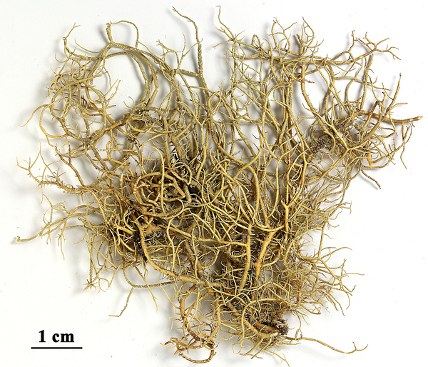
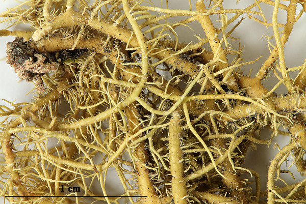
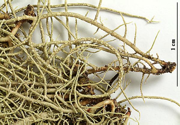
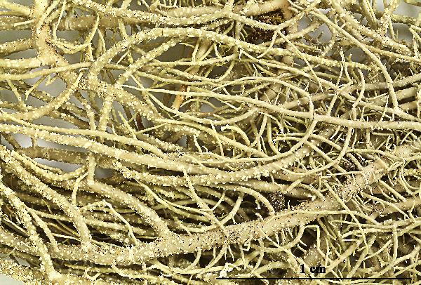
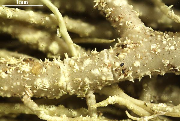
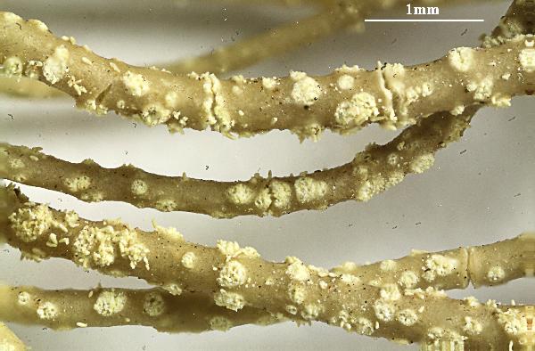
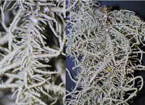
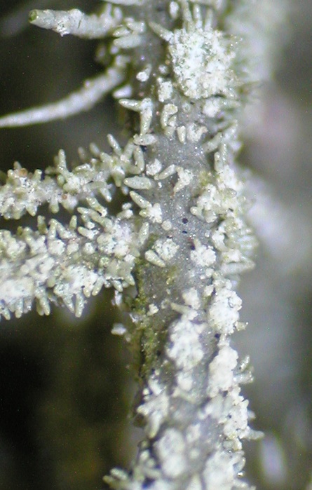
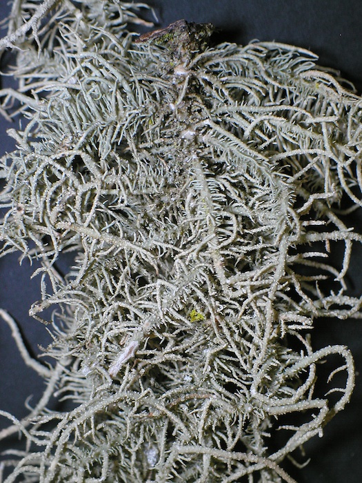
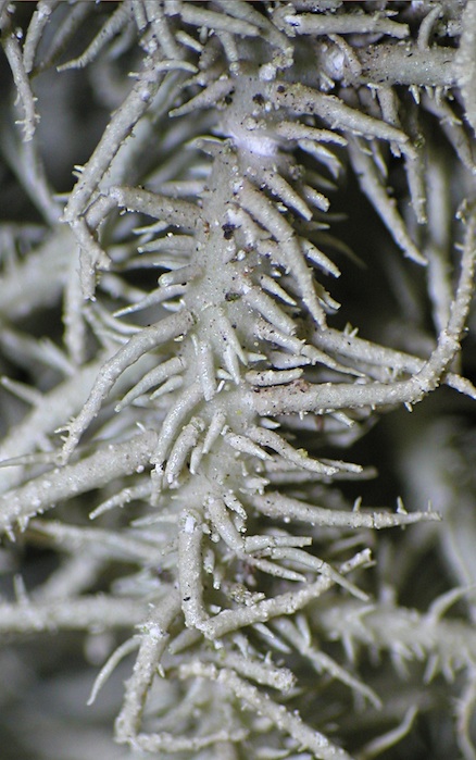
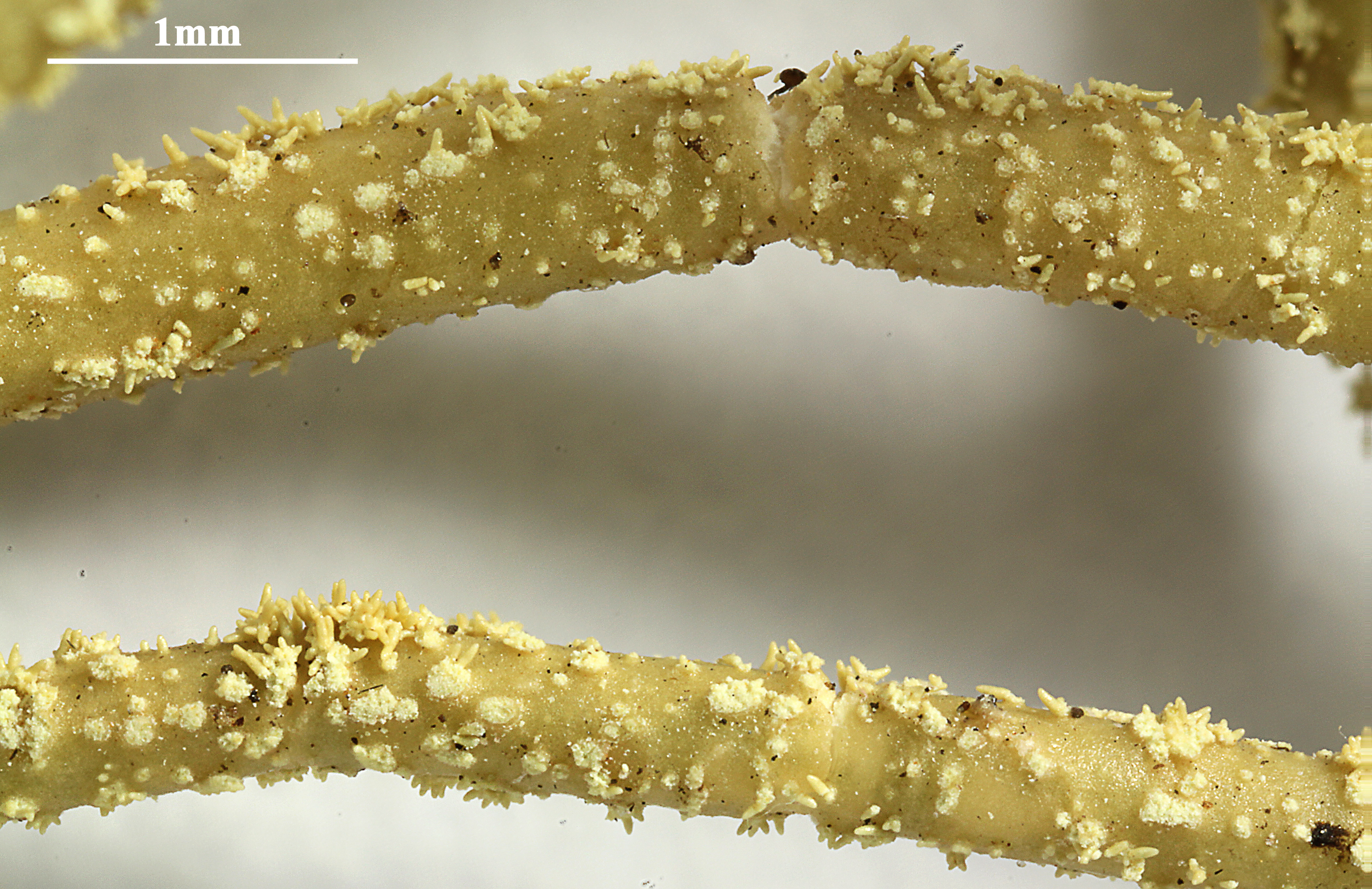
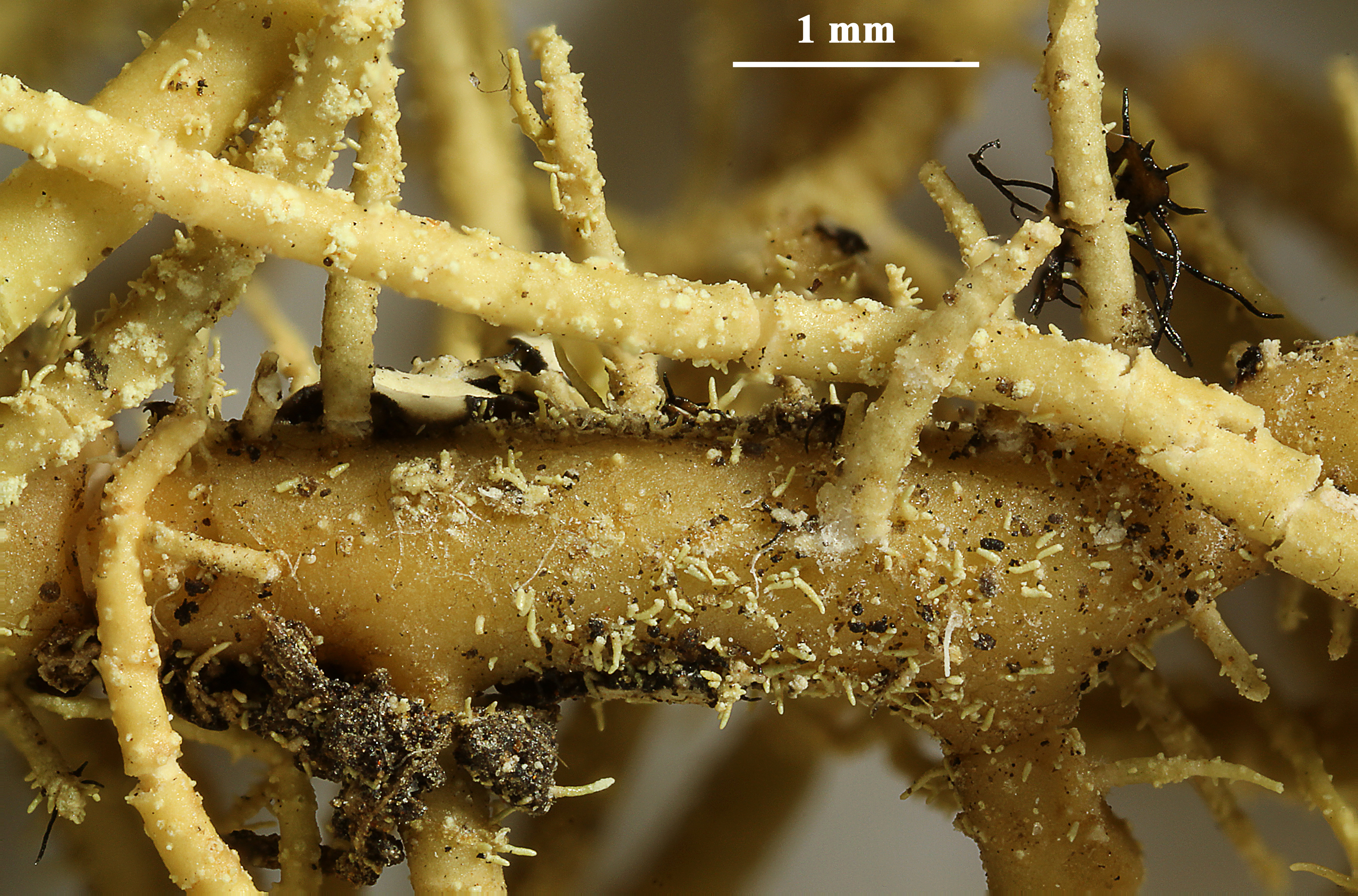
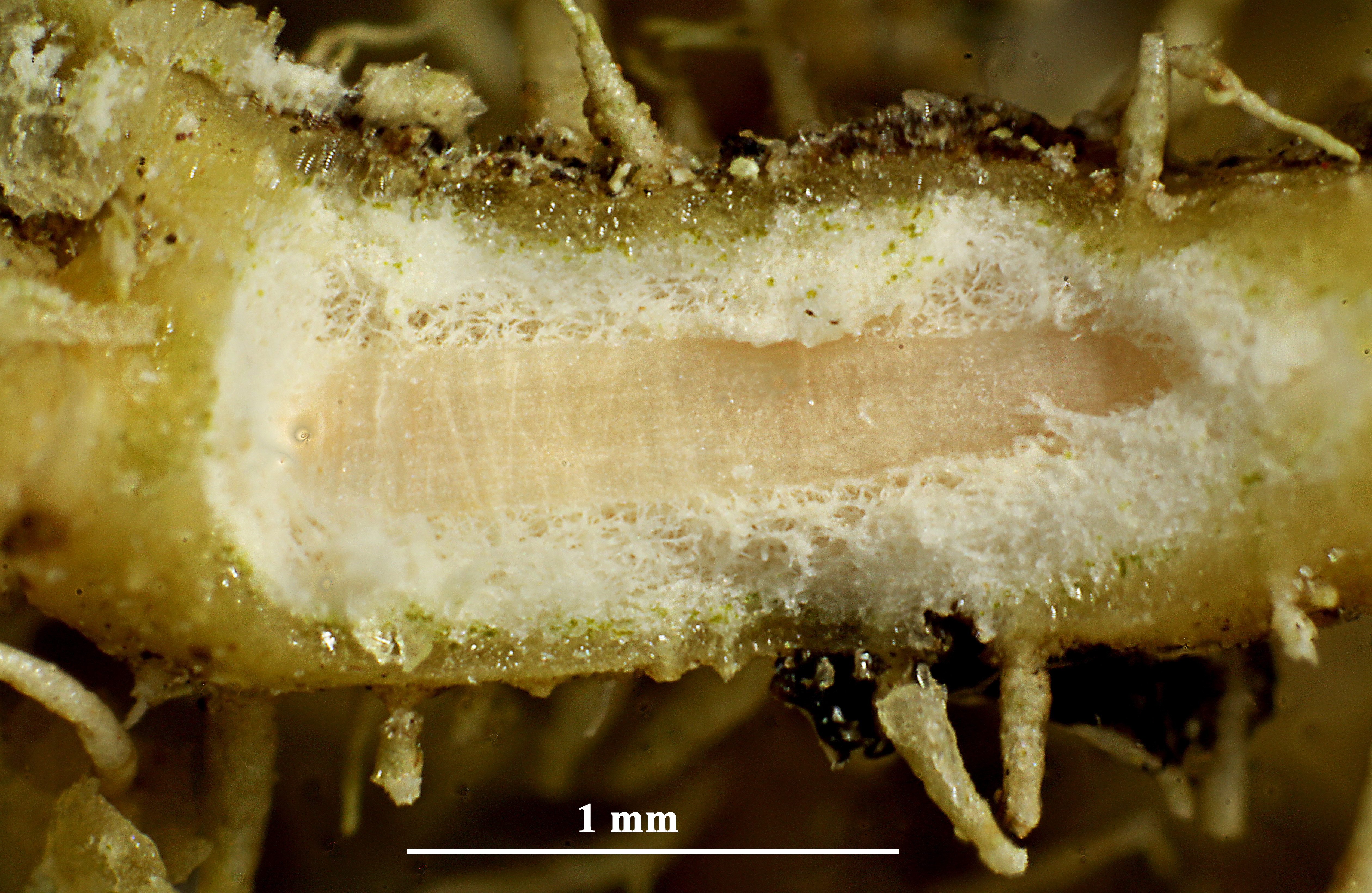
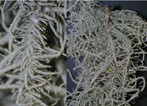
Description: Thallus fruticose-filamentous, greenish, shrubby to subpendulous, up to 15 cm long, branching mainly anisotomic-dichotomously with divergent branches. Main branches cylindrical to irregular, more or less provided with annular cracks, pale and without conspicuous cracks at base; lateral branches often slightly to distinctly constricted at attachment point; papillae and tubercles absent; fibrils numerous, 1-2(-3) mm long, irregularly distributed and most dense in the basal parts, spinulose, tending to fall off, leaving scars from which soralia may originate. Soralia punctiform to longitudinally elliptical, convex, often confluent and forming irregular masses of soredia occupying less than the half of the diameter of the branch, often with 0.15-0.3 mm long, clustered isidiomorphs. Cortex shiny in longitudinal section, thin (4–9% of total branch thickness); medulla heterogeneous, with a narrow, compact ring below the cortex, otherwise dense and thick (25-29%), white to faintly pink-orange in internal part; central axis white or faintly pink-orange in peripheral part, moderately thick (25-34%). Apothecia usually absent. Photobiont chlorococcoid. Spot tests: cortex K-, C-, KC-, P-; medulla K+ yellow turning dark red, C-, KC-, P+ yellow-orange. Chemistry: cortex with usnic acid; medulla with galbínic, norstictic and salazínic acids (all major), or very rarely only with salazinic (major) and norstictic (major) acids, or with psoromic acid (major).
Growth form: Fruticose filamentous
Substrata: bark
Photobiont: green algae other than Trentepohlia
Reproductive strategy: mainly asexual, by soredia, or soredia-like structures (e.g. blastidia)
Most common in areas with a humid-warm climate (e.g. most of Tyrrenian Italy)
Commonnes-rarity: (info)
Alpine belt: absent
Subalpine belt: absent
Montane belt: absent
Dry submediterranean belt: very rare
Humid submediterranean belt: absent
Padanian area: absent
pH of the substrata:
1 2 3 4 5

Solar irradiation:
1 2 3 4 5
Aridity:
1 2 3 4 5
Eutrophication:
1 2 3 4 5
Poleotolerance:
0 1 2 3
Altitudinal distribution:
1 2 3 4 5 6
Rarity
absent
extremely rare
very rare
rare
rather rare
rather common
common
very common
extremely common
Loading data...
Occurrence data
Predictive map

Tiiu Tõrra; Owner: Tiiu Tõrra - Institute of Ecology and Earth Sciences, University of Tartu, Estonia

Tiiu Tõrra; Owner: Tiiu Tõrra - Institute of Ecology and Earth Sciences, University of Tartu, Estonia

Tiiu Tõrra; Owner: Tiiu Tõrra - Institute of Ecology and Earth Sciences, University of Tartu, Estonia
Tiiu Tõrra; Owner: Tiiu Tõrra - Institute of Ecology and Earth Sciences, University of Tartu, Estonia
Tiiu Tõrra; Owner: Tiiu Tõrra - Institute of Ecology and Earth Sciences, University of Tartu, Estonia
Tiiu Tõrra; Owner: Tiiu Tõrra - Institute of Ecology and Earth Sciences, University of Tartu, Estonia
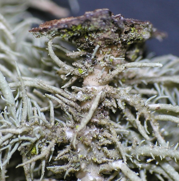
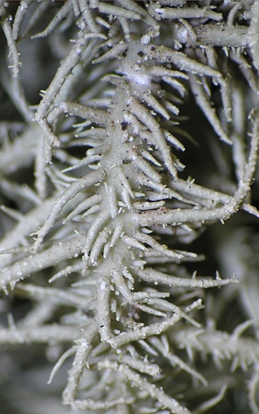
Felix Schumm - CC BY-SA 4.0
[16230], Australia, New South Wales, between Bermagui and Tathra, road from Aragunnu Beach to Mimosa Rocks, 36.58529° S, 150.05618° E, 10 m. Leg. F. Schumm & E. Stocker-Wörgötter, 12.11.2009, det. J.A. Elix.
Felix Schumm - CC BY-SA 4.0
[16230], Australia, New South Wales, between Bermagui and Tathra, road from Aragunnu Beach to Mimosa Rocks, 36.58529° S, 150.05618° E, 10 m. Leg. F. Schumm & E. Stocker-Wörgötter, 12.11.2009, det. J.A. Elix.

Felix Schumm - CC BY-SA 4.0
[16230], Australia, New South Wales, between Bermagui and Tathra, road from Aragunnu Beach to Mimosa Rocks, 36.58529° S, 150.05618° E, 10 m. Leg. F. Schumm & E. Stocker-Wörgötter, 12.11.2009, det. J.A. Elix.

Felix Schumm - CC BY-SA 4.0
[16230], Australia, New South Wales, between Bermagui and Tathra, road from Aragunnu Beach to Mimosa Rocks, 36.58529° S, 150.05618° E, 10 m. Leg. F. Schumm & E. Stocker-Wörgötter, 12.11.2009, det. J.A. Elix.

Felix Schumm - CC BY-SA 4.0
[16230], Australia, New South Wales, between Bermagui and Tathra, road from Aragunnu Beach to Mimosa Rocks, 36.58529° S, 150.05618° E, 10 m. Leg. F. Schumm & E. Stocker-Wörgötter, 12.11.2009, det. J.A. Elix.

Tiiu Tõrra; Owner: Tiiu Tõrra - Institute of Ecology and Earth Sciences, University of Tartu, Estonia
Felix Schumm - CC BY-SA 4.0
[ABL50829], Brazil, Alagoas, Quebrangulo, Pedra Talhada private
area. On tree bark in Atlantic rain forest. 9°15’ S, 36°25’35’’ W, 500 m.
Leg. M. Cáceres, A. Aptroot (no 50829) & J.G. Cavalcante, 24.07.2019.
Det. A. Aptroot, 2019.
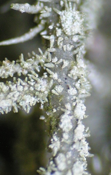
Felix Schumm - CC BY-SA 4.0
[ABL50829], Brazil, Alagoas, Quebrangulo, Pedra Talhada private
area. On tree bark in Atlantic rain forest. 9°15’ S, 36°25’35’’ W, 500 m.
Leg. M. Cáceres, A. Aptroot (no 50829) & J.G. Cavalcante, 24.07.2019.
Det. A. Aptroot, 2019.
Felix Schumm - CC BY-SA 4.0
[ABL50829], Brazil, Alagoas, Quebrangulo, Pedra Talhada private
area. On tree bark in Atlantic rain forest. 9°15’ S, 36°25’35’’ W, 500 m.
Leg. M. Cáceres, A. Aptroot (no 50829) & J.G. Cavalcante, 24.07.2019.
Det. A. Aptroot, 2019.
Felix Schumm - CC BY-SA 4.0
[ABL50829], Brazil, Alagoas, Quebrangulo, Pedra Talhada private
area. On tree bark in Atlantic rain forest. 9°15’ S, 36°25’35’’ W, 500 m.
Leg. M. Cáceres, A. Aptroot (no 50829) & J.G. Cavalcante, 24.07.2019.
Det. A. Aptroot, 2019.
Growth form: Fruticose filamentous
Substrata: bark
Photobiont: green algae other than Trentepohlia
Reproductive strategy: mainly asexual, by soredia, or soredia-like structures (e.g. blastidia)
Most common in areas with a humid-warm climate (e.g. most of Tyrrenian Italy)
Commonnes-rarity: (info)
Alpine belt: absent
Subalpine belt: absent
Montane belt: absent
Dry submediterranean belt: very rare
Humid submediterranean belt: absent
Padanian area: absent
pH of the substrata:
| 1 | 2 | 3 | 4 | 5 |
Solar irradiation:
| 1 | 2 | 3 | 4 | 5 |
Aridity:
| 1 | 2 | 3 | 4 | 5 |
Eutrophication:
| 1 | 2 | 3 | 4 | 5 |
Poleotolerance:
| 0 | 1 | 2 | 3 |
Altitudinal distribution:
| 1 | 2 | 3 | 4 | 5 | 6 |
Rarity
absent
extremely rare
very rare
rare
rather rare
rather common
common
very common
extremely common
Loading data...
Occurrence data
Predictive map
Tiiu Tõrra; Owner: Tiiu Tõrra - Institute of Ecology and Earth Sciences, University of Tartu, Estonia
Tiiu Tõrra; Owner: Tiiu Tõrra - Institute of Ecology and Earth Sciences, University of Tartu, Estonia
Tiiu Tõrra; Owner: Tiiu Tõrra - Institute of Ecology and Earth Sciences, University of Tartu, Estonia

Tiiu Tõrra; Owner: Tiiu Tõrra - Institute of Ecology and Earth Sciences, University of Tartu, Estonia
Tiiu Tõrra; Owner: Tiiu Tõrra - Institute of Ecology and Earth Sciences, University of Tartu, Estonia

Tiiu Tõrra; Owner: Tiiu Tõrra - Institute of Ecology and Earth Sciences, University of Tartu, Estonia

Felix Schumm - CC BY-SA 4.0
[16230], Australia, New South Wales, between Bermagui and Tathra, road from Aragunnu Beach to Mimosa Rocks, 36.58529° S, 150.05618° E, 10 m. Leg. F. Schumm & E. Stocker-Wörgötter, 12.11.2009, det. J.A. Elix.

Felix Schumm - CC BY-SA 4.0
[16230], Australia, New South Wales, between Bermagui and Tathra, road from Aragunnu Beach to Mimosa Rocks, 36.58529° S, 150.05618° E, 10 m. Leg. F. Schumm & E. Stocker-Wörgötter, 12.11.2009, det. J.A. Elix.
Felix Schumm - CC BY-SA 4.0
[16230], Australia, New South Wales, between Bermagui and Tathra, road from Aragunnu Beach to Mimosa Rocks, 36.58529° S, 150.05618° E, 10 m. Leg. F. Schumm & E. Stocker-Wörgötter, 12.11.2009, det. J.A. Elix.
Felix Schumm - CC BY-SA 4.0
[16230], Australia, New South Wales, between Bermagui and Tathra, road from Aragunnu Beach to Mimosa Rocks, 36.58529° S, 150.05618° E, 10 m. Leg. F. Schumm & E. Stocker-Wörgötter, 12.11.2009, det. J.A. Elix.
Felix Schumm - CC BY-SA 4.0
[16230], Australia, New South Wales, between Bermagui and Tathra, road from Aragunnu Beach to Mimosa Rocks, 36.58529° S, 150.05618° E, 10 m. Leg. F. Schumm & E. Stocker-Wörgötter, 12.11.2009, det. J.A. Elix.
Tiiu Tõrra; Owner: Tiiu Tõrra - Institute of Ecology and Earth Sciences, University of Tartu, Estonia

Felix Schumm - CC BY-SA 4.0
[ABL50829], Brazil, Alagoas, Quebrangulo, Pedra Talhada private area. On tree bark in Atlantic rain forest. 9°15’ S, 36°25’35’’ W, 500 m. Leg. M. Cáceres, A. Aptroot (no 50829) & J.G. Cavalcante, 24.07.2019. Det. A. Aptroot, 2019.

Felix Schumm - CC BY-SA 4.0
[ABL50829], Brazil, Alagoas, Quebrangulo, Pedra Talhada private area. On tree bark in Atlantic rain forest. 9°15’ S, 36°25’35’’ W, 500 m. Leg. M. Cáceres, A. Aptroot (no 50829) & J.G. Cavalcante, 24.07.2019. Det. A. Aptroot, 2019.

Felix Schumm - CC BY-SA 4.0
[ABL50829], Brazil, Alagoas, Quebrangulo, Pedra Talhada private area. On tree bark in Atlantic rain forest. 9°15’ S, 36°25’35’’ W, 500 m. Leg. M. Cáceres, A. Aptroot (no 50829) & J.G. Cavalcante, 24.07.2019. Det. A. Aptroot, 2019.


