
Verrucaria murina Leight.
Angioc. Lich.: 59, 1851.
Synonyms: Amphoridium myriocarpum (Hepp ex Lönnr.) Servít; Verrucaria brachyspora Arnold?; Verrucaria myriocarpa Hepp ex Lönnr.; Verrucaria pazientii A. Massal.?
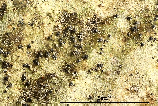
Description: Thallus crustose, endosubstratic or hemiendosubstratic, grey, grey-brown or pale olive-brown, rarely dark brown, forming small flecks and patches, often with a thin dark prothallus but not forming mosaics. Cortex differentiated into a lithocortex, densely
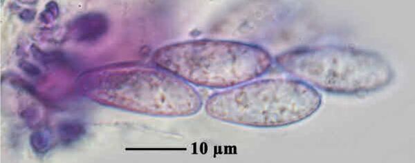
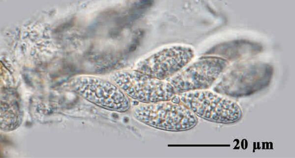
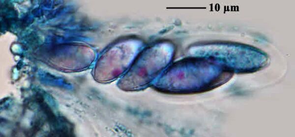
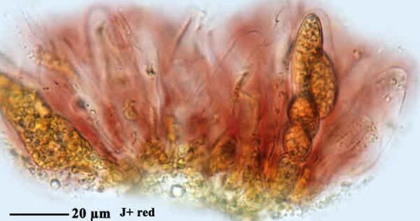
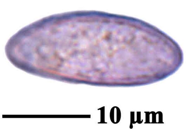
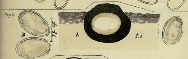
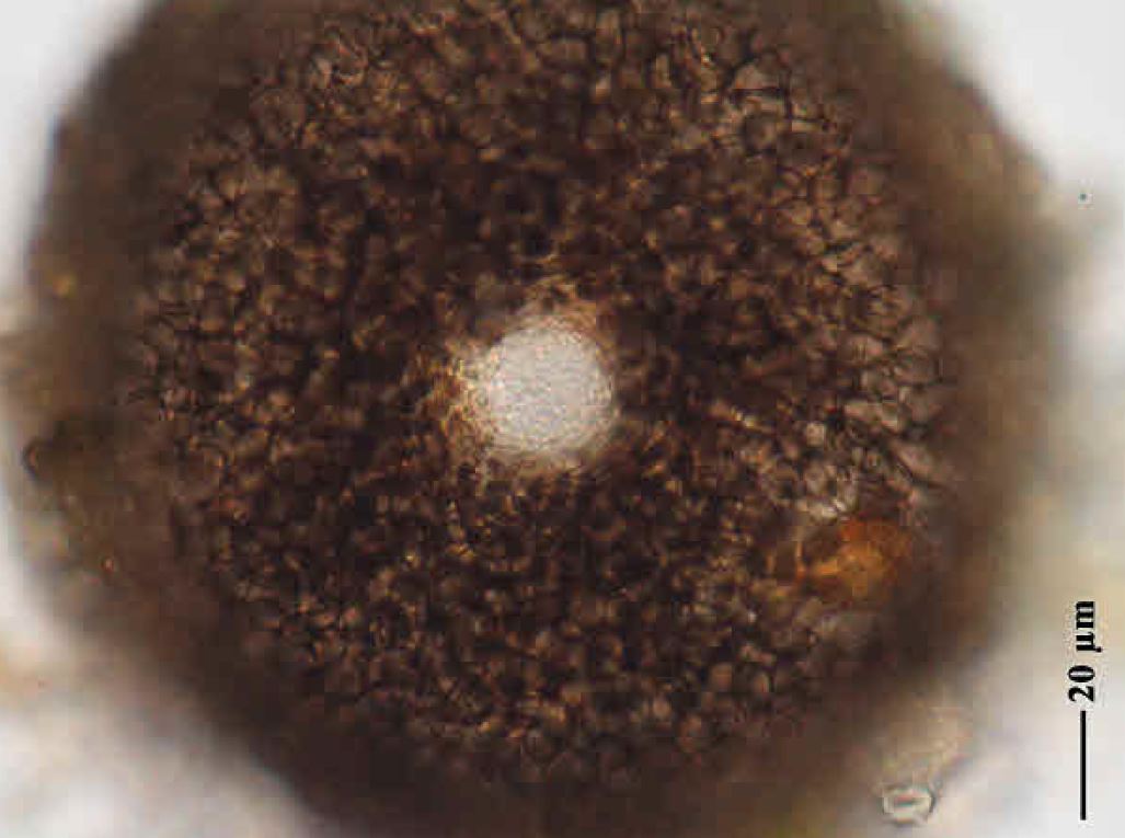
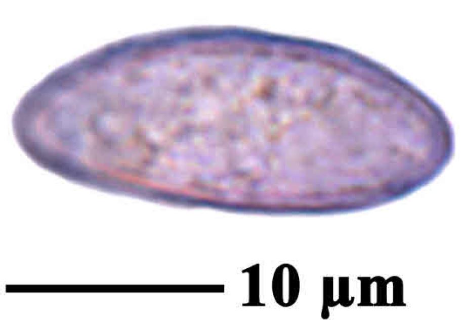
prosoplectenchymatous, up to 20-30 μm thick; algal layer discontinuous, 80-120 μm thick, the algal cells in clusters; medulla prosoplectenchymatous, thin, not forming a black basal layer. Perithecia numerous, black, very small, 0.12-0.2(-0.28) mm across, forming moderate to prominent projections, the apex often flattened or slightly concave, with an often paler ostiole, the base not covered by thallus. Involucrellum appressed to exciple and scarcely distinguishable from it, or appressed in upper part and spreading in lower part, reaching to base-level; exciple up to 0.2 mm across, black; hamathecium of 20-25 μm long periphysoids, interascal filaments absent; hymenial gel hemiamyloid, I+ red (I+ blue at very low concentrations of I), K/I+ blue. Asci 8-spored, clavate, I-, fissitunicate, the wall thickened above, with an ocular chamber, dehiscent by extrusion of an endotunica to form a delicate rostrum, Verrucaria-type, 45-50 x 15-20 μm. Ascospores 1-celled, hyaline, ellipsoid, (13.5-)18-24(-28.5) x (6-)8-12(-14) μm. Photobiont chlorococcoid. Spot tests: K-, C-, KC-, P-, UV-. Chemistry: without lichen substances.
Growth form: Crustose endolithic
Substrata: rocks
Photobiont: green algae other than Trentepohlia
Reproductive strategy: mainly sexual
Poorly known taxon in need of further study
Commonnes-rarity: (info)
Alpine belt: very rare
Subalpine belt: very rare
Montane belt: very rare
Dry submediterranean belt: extremely rare
Humid submediterranean belt: extremely rare
Padanian area: absent
pH of the substrata:
1 2 3 4 5

Solar irradiation:
1 2 3 4 5
Aridity:
1 2 3 4 5
Eutrophication:
1 2 3 4 5
Poleotolerance:
0 1 2 3
Altitudinal distribution:
1 2 3 4 5 6
Rarity
absent
extremely rare
very rare
rare
rather rare
rather common
common
very common
extremely common
Loading data...
Occurrence data
Predictive map

Felix Schumm – CC BY-SA 4.0
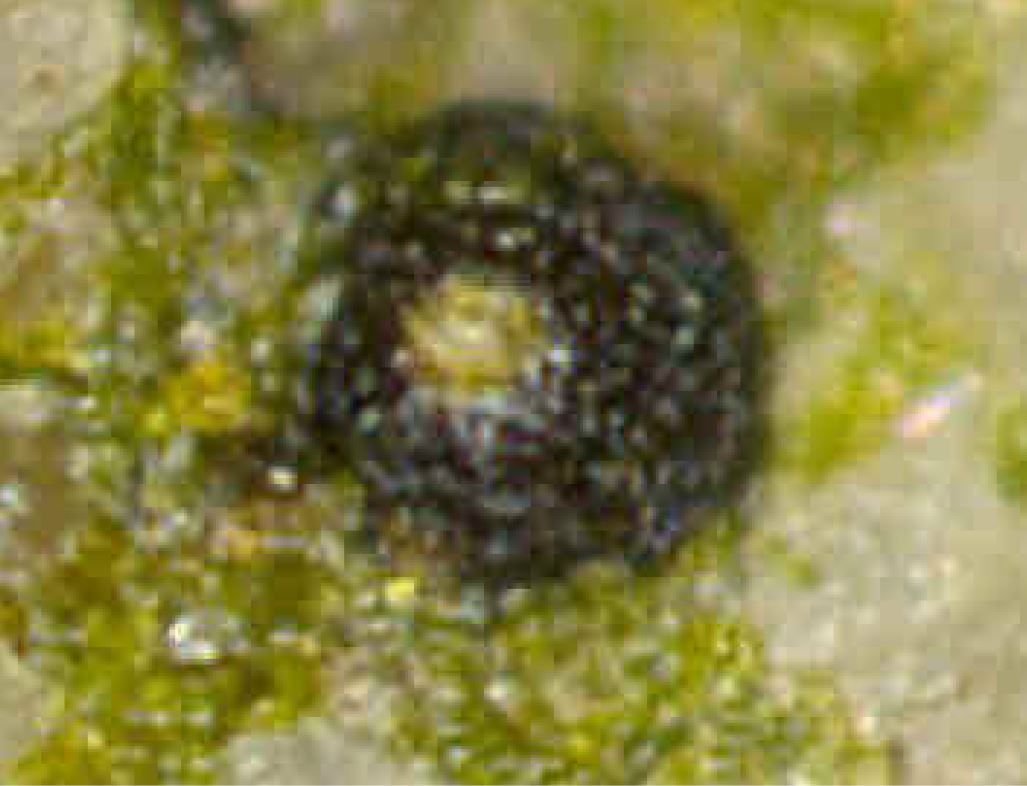
[19317], Germany, Baden-Württemberg, Kreis Göppingen, Waldgebiet 2.3 km nordwestlich von Wangen, 48.74312° N, 9.58412 ° E, 455 m, auf feuchten, am Boden liegenden Sandsteinchen auf dem Brosenholzweg. Leg. F. Schumm 09.04.2015, det F. Schumm 2015
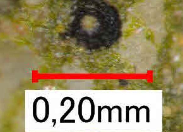
Felix Schumm – CC BY-SA 4.0
[19317], Germany, Baden-Württemberg, Kreis Göppingen, Waldgebiet 2.3 km nordwestlich von Wangen, 48.74312° N, 9.58412 ° E, 455 m, auf feuchten, am Boden liegenden Sandsteinchen auf dem Brosenholzweg. Leg. F. Schumm 09.04.2015, det F. Schumm 2015

Felix Schumm – CC BY-SA 4.0
[19317], Germany, Baden-Württemberg, Kreis Göppingen, Waldgebiet 2.3 km nordwestlich von Wangen, 48.74312° N, 9.58412 ° E, 455 m, auf feuchten, am Boden liegenden Sandsteinchen auf dem Brosenholzweg. Leg. F. Schumm 09.04.2015, det F. Schumm 2015
Felix Schumm – CC BY-SA 4.0
[19317], Germany, Baden-Württemberg, Kreis Göppingen, Waldgebiet 2.3 km nordwestlich von Wangen, 48.74312° N, 9.58412 ° E, 455 m, auf feuchten, am Boden liegenden Sandsteinchen auf dem Brosenholzweg. Leg. F. Schumm 09.04.2015, det F. Schumm 2015
Felix Schumm – CC BY-SA 4.0
[19317], Germany, Baden-Württemberg, Kreis Göppingen, Waldgebiet 2.3 km nordwestlich von Wangen, 48.74312° N, 9.58412 ° E, 455 m, auf feuchten, am Boden liegenden Sandsteinchen auf dem Brosenholzweg. Leg. F. Schumm 09.04.2015, det F. Schumm 2015
Felix Schumm – CC BY-SA 4.0
[19317], Germany, Baden-Württemberg, Kreis Göppingen, Waldgebiet 2.3 km nordwestlich von Wangen, 48.74312° N, 9.58412 ° E, 455 m, auf feuchten, am Boden liegenden Sandsteinchen auf dem Brosenholzweg. Leg. F. Schumm 09.04.2015, det F. Schumm 2015
Felix Schumm – CC BY-SA 4.0
[19317], Germany, Baden-Württemberg, Kreis Göppingen, Waldgebiet 2.3 km nordwestlich von Wangen, 48.74312° N, 9.58412 ° E, 455 m, auf feuchten, am Boden liegenden Sandsteinchen auf dem Brosenholzweg. Leg. F. Schumm 09.04.2015, det F. Schumm 2015
Felix Schumm – CC BY-SA 4.0
[19317], Germany, Baden-Württemberg, Kreis Göppingen, Waldgebiet 2.3 km nordwestlich von Wangen, 48.74312° N, 9.58412 ° E, 455 m, auf feuchten, am Boden liegenden Sandsteinchen auf dem Brosenholzweg. Leg. F. Schumm 09.04.2015, det F. Schumm 2015

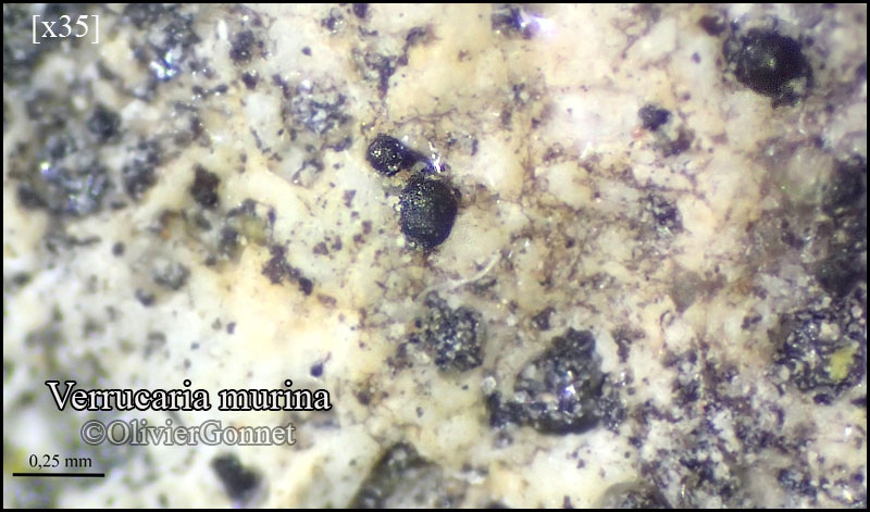
Courtesy Danièle et Olivier Gonnet - Source: https://www.afl-lichenologie.fr/Photos_AFL/Photos_AFL_V/Texte_V/Verrucaria_murina.htm
France, session AFL 2015 - Saint-Sozy - Lot
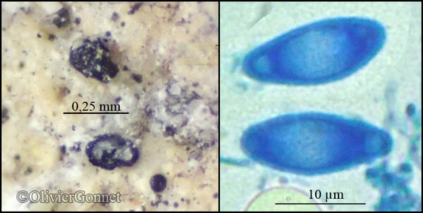
Courtesy Danièle et Olivier Gonnet - Source: https://www.afl-lichenologie.fr/Photos_AFL/Photos_AFL_V/Texte_V/Verrucaria_murina.htm
France, session AFL 2015 - Saint-Sozy - Lot
Felix Schumm - CC BY-SA 4.0
[ABL18136], Brazil, Sergipe, Parque National Serra de Itabaiana.
10°44'35'' S, 37°20'25'' W, 400 m. On quarzite rock. Leg. M. Cáceres &
A. Aptroot, (no. 18136), 27 July 2013, det. A. Aptroot 2013.
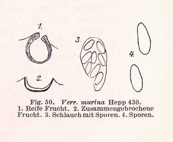
Zschacke, H. (1934) Epigloeaceae, Verrucariaceae und Dermatocarpaceae. In: Dr. L. Rabenhorst‘s Kryptogamen-Flora, Band 9, Abt. 1, Teil 1. Akademische Verlagsgesellschaft, Leipzig, 695 pp. - Public Domain
Spurce: Leighton, Brit. Sp. Ang. Lich.: 44 (1851)
Public Domain

Source: Servít M. 1950b. The new lichens of the Pyrenocarpae-group III. Studia Bot. Cechoslov. 11, (1-2): 7-41.
Growth form: Crustose endolithic
Substrata: rocks
Photobiont: green algae other than Trentepohlia
Reproductive strategy: mainly sexual
Poorly known taxon in need of further study
Commonnes-rarity: (info)
Alpine belt: very rare
Subalpine belt: very rare
Montane belt: very rare
Dry submediterranean belt: extremely rare
Humid submediterranean belt: extremely rare
Padanian area: absent
pH of the substrata:
| 1 | 2 | 3 | 4 | 5 |
Solar irradiation:
| 1 | 2 | 3 | 4 | 5 |
Aridity:
| 1 | 2 | 3 | 4 | 5 |
Eutrophication:
| 1 | 2 | 3 | 4 | 5 |
Poleotolerance:
| 0 | 1 | 2 | 3 |
Altitudinal distribution:
| 1 | 2 | 3 | 4 | 5 | 6 |
Rarity
absent
extremely rare
very rare
rare
rather rare
rather common
common
very common
extremely common
Loading data...
Occurrence data
Predictive map
Felix Schumm – CC BY-SA 4.0
[19317], Germany, Baden-Württemberg, Kreis Göppingen, Waldgebiet 2.3 km nordwestlich von Wangen, 48.74312° N, 9.58412 ° E, 455 m, auf feuchten, am Boden liegenden Sandsteinchen auf dem Brosenholzweg. Leg. F. Schumm 09.04.2015, det F. Schumm 2015

Felix Schumm – CC BY-SA 4.0
[19317], Germany, Baden-Württemberg, Kreis Göppingen, Waldgebiet 2.3 km nordwestlich von Wangen, 48.74312° N, 9.58412 ° E, 455 m, auf feuchten, am Boden liegenden Sandsteinchen auf dem Brosenholzweg. Leg. F. Schumm 09.04.2015, det F. Schumm 2015
Felix Schumm – CC BY-SA 4.0
[19317], Germany, Baden-Württemberg, Kreis Göppingen, Waldgebiet 2.3 km nordwestlich von Wangen, 48.74312° N, 9.58412 ° E, 455 m, auf feuchten, am Boden liegenden Sandsteinchen auf dem Brosenholzweg. Leg. F. Schumm 09.04.2015, det F. Schumm 2015

Felix Schumm – CC BY-SA 4.0
[19317], Germany, Baden-Württemberg, Kreis Göppingen, Waldgebiet 2.3 km nordwestlich von Wangen, 48.74312° N, 9.58412 ° E, 455 m, auf feuchten, am Boden liegenden Sandsteinchen auf dem Brosenholzweg. Leg. F. Schumm 09.04.2015, det F. Schumm 2015

Felix Schumm – CC BY-SA 4.0
[19317], Germany, Baden-Württemberg, Kreis Göppingen, Waldgebiet 2.3 km nordwestlich von Wangen, 48.74312° N, 9.58412 ° E, 455 m, auf feuchten, am Boden liegenden Sandsteinchen auf dem Brosenholzweg. Leg. F. Schumm 09.04.2015, det F. Schumm 2015

Felix Schumm – CC BY-SA 4.0
[19317], Germany, Baden-Württemberg, Kreis Göppingen, Waldgebiet 2.3 km nordwestlich von Wangen, 48.74312° N, 9.58412 ° E, 455 m, auf feuchten, am Boden liegenden Sandsteinchen auf dem Brosenholzweg. Leg. F. Schumm 09.04.2015, det F. Schumm 2015

Felix Schumm – CC BY-SA 4.0
[19317], Germany, Baden-Württemberg, Kreis Göppingen, Waldgebiet 2.3 km nordwestlich von Wangen, 48.74312° N, 9.58412 ° E, 455 m, auf feuchten, am Boden liegenden Sandsteinchen auf dem Brosenholzweg. Leg. F. Schumm 09.04.2015, det F. Schumm 2015
Felix Schumm – CC BY-SA 4.0
[19317], Germany, Baden-Württemberg, Kreis Göppingen, Waldgebiet 2.3 km nordwestlich von Wangen, 48.74312° N, 9.58412 ° E, 455 m, auf feuchten, am Boden liegenden Sandsteinchen auf dem Brosenholzweg. Leg. F. Schumm 09.04.2015, det F. Schumm 2015
Courtesy Danièle et Olivier Gonnet - Source: https://www.afl-lichenologie.fr/Photos_AFL/Photos_AFL_V/Texte_V/Verrucaria_murina.htm
France, session AFL 2015 - Saint-Sozy - Lot

Courtesy Danièle et Olivier Gonnet - Source: https://www.afl-lichenologie.fr/Photos_AFL/Photos_AFL_V/Texte_V/Verrucaria_murina.htm
France, session AFL 2015 - Saint-Sozy - Lot

Felix Schumm - CC BY-SA 4.0
[ABL18136], Brazil, Sergipe, Parque National Serra de Itabaiana. 10°44'35'' S, 37°20'25'' W, 400 m. On quarzite rock. Leg. M. Cáceres & A. Aptroot, (no. 18136), 27 July 2013, det. A. Aptroot 2013.
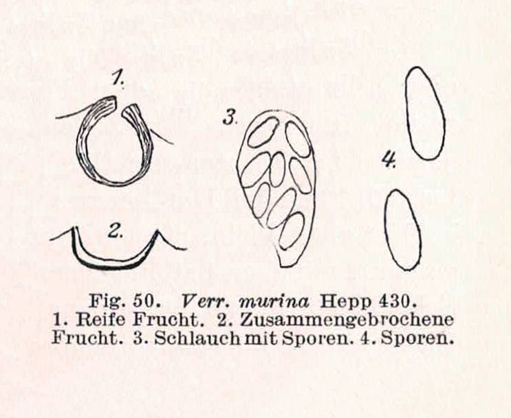
Zschacke, H. (1934) Epigloeaceae, Verrucariaceae und Dermatocarpaceae. In: Dr. L. Rabenhorst‘s Kryptogamen-Flora, Band 9, Abt. 1, Teil 1. Akademische Verlagsgesellschaft, Leipzig, 695 pp. - Public Domain

Spurce: Leighton, Brit. Sp. Ang. Lich.: 44 (1851)
Public Domain


