
Verrucaria nigrescens Pers.
Ann. Bot. (Usteri), 15: 36, 1795.
Synonyms: Lithocia acrotelloides (A. Massal.) A. Massal.; Lithocia controversa (A. Massal.) A. Massal.; Lithocia controversa var. protothallina A. Massal.; Lithocia funckii sensu A. Massal.; Lithocia nigrescens (Pers.) A. Massal.; Lithoicea nigrescens var. acrotella A. Massal.; Verrucaria acrotelloides A. Massal.; Verrucaria controversa A. Massal.; Verrucaria fusca auct. non Pers.; Verrucaria fuscoatra Pers.; Verrucaria nigrescens f. virescens Anzi; Verrucaria nigrescens var. acrotelloides (A. Massal.) Trevis.; Verrucaria nigrescens var. funckii (A. Massal.) Zwackh non Verrucaria funckii (Spreng.) Zahlbr.; Verrucaria nigroumbrina f. acrotella (A. Massal.) Servít; Verrucaria umbrina var. nigrescens (Pers.) Ach.; Verrucaria velana (A. Massal.) Zahlbr.
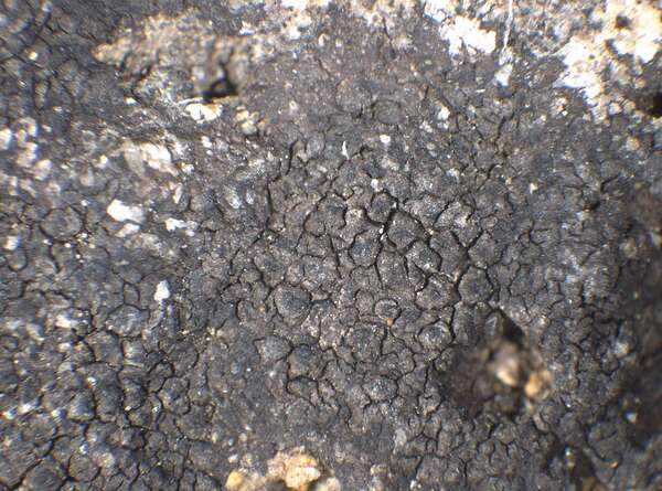
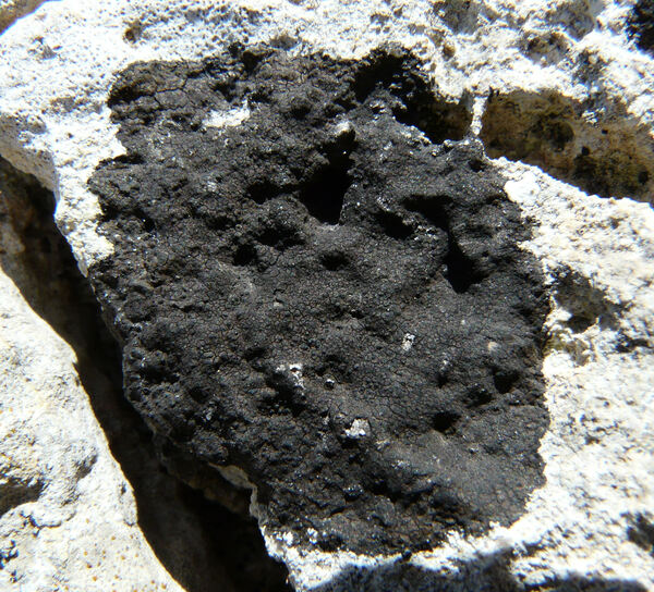
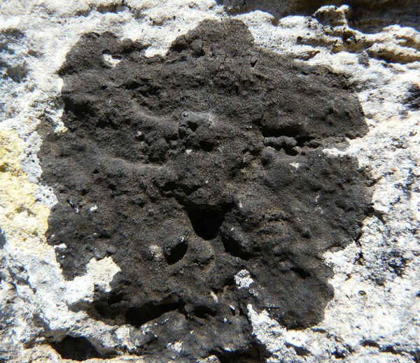
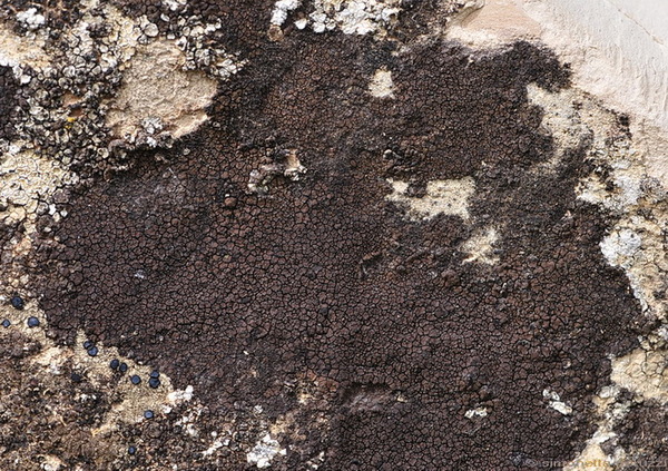
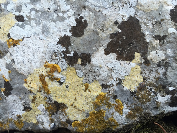
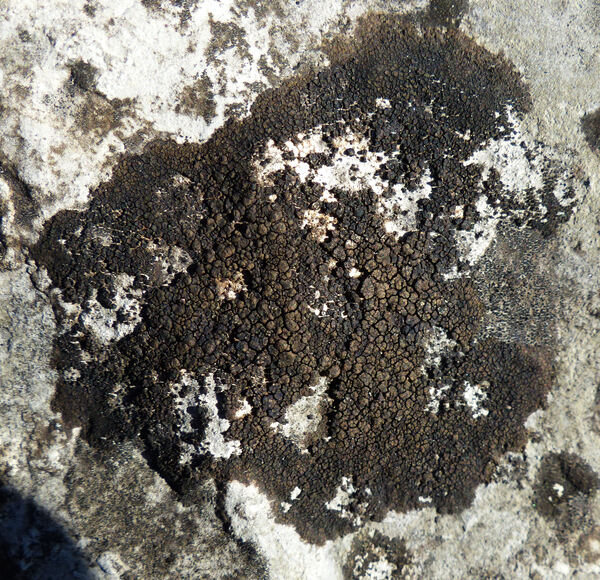
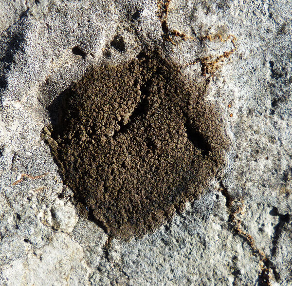
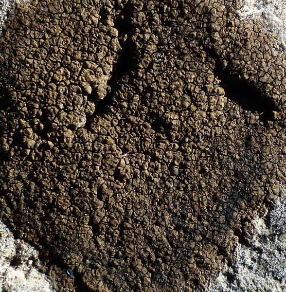
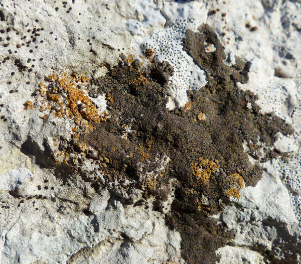
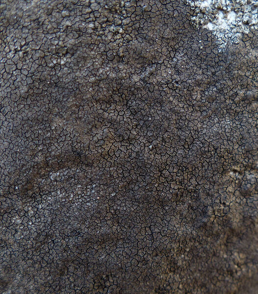
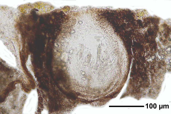
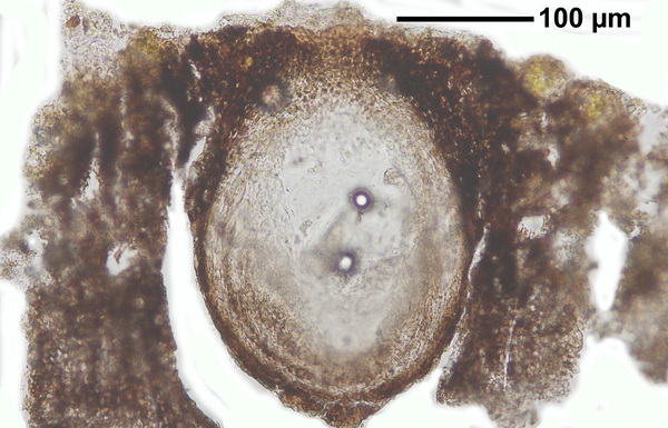
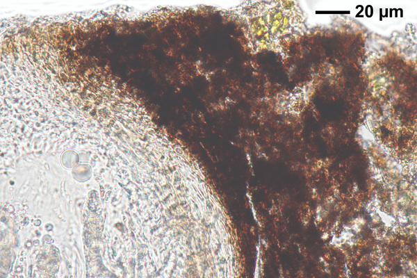
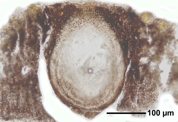
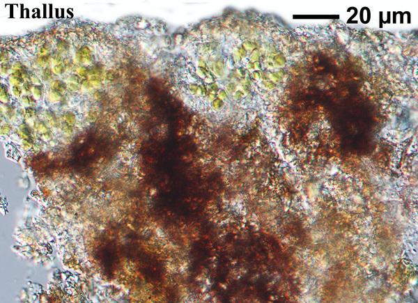
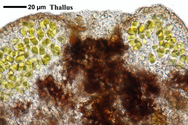
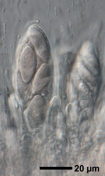
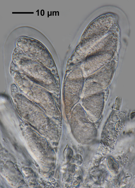
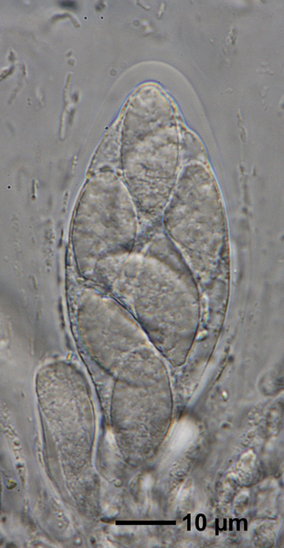
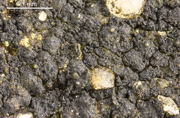
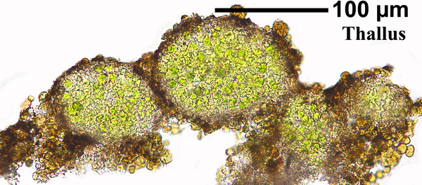
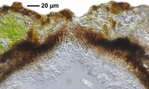
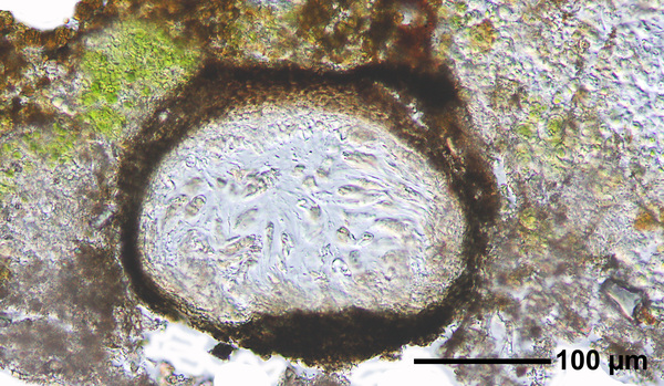
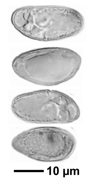
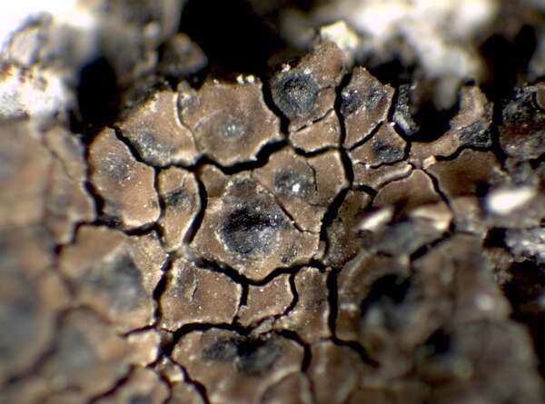
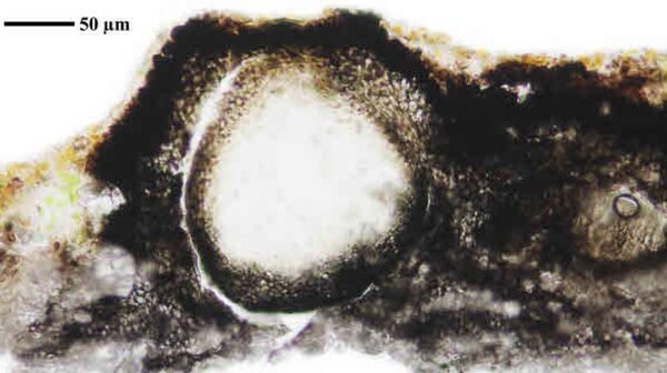
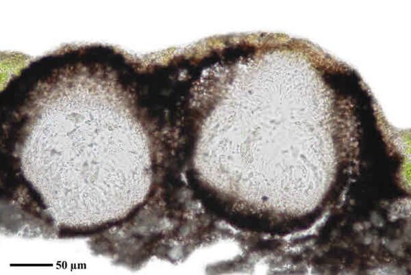
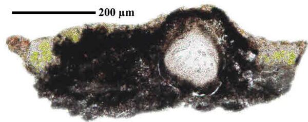
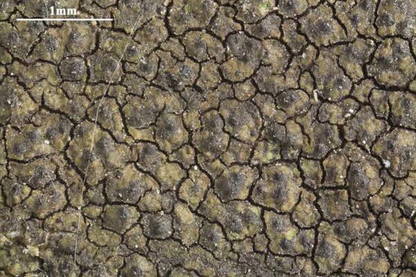
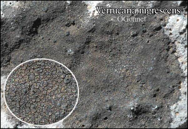
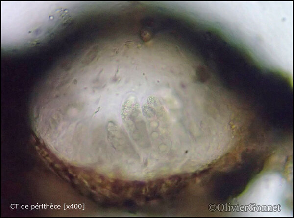
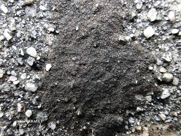
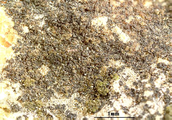
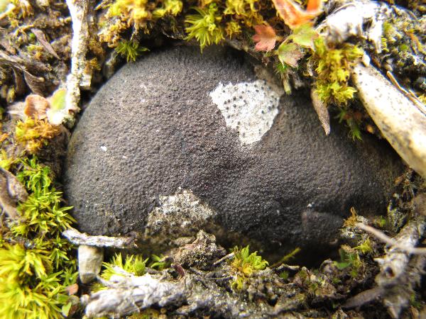
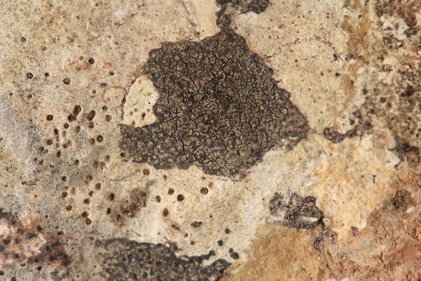
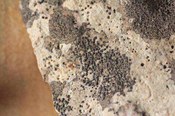
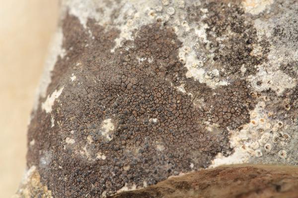
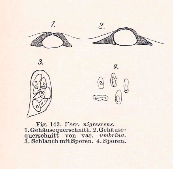
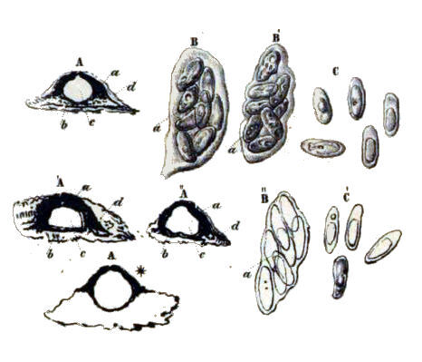
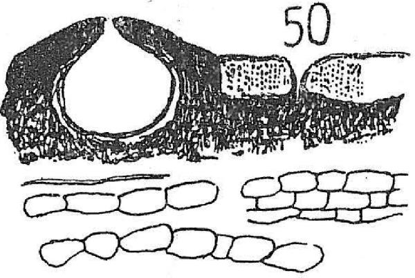
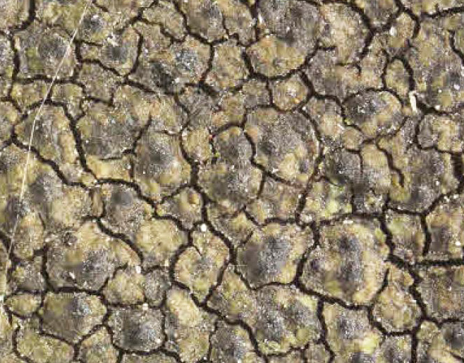
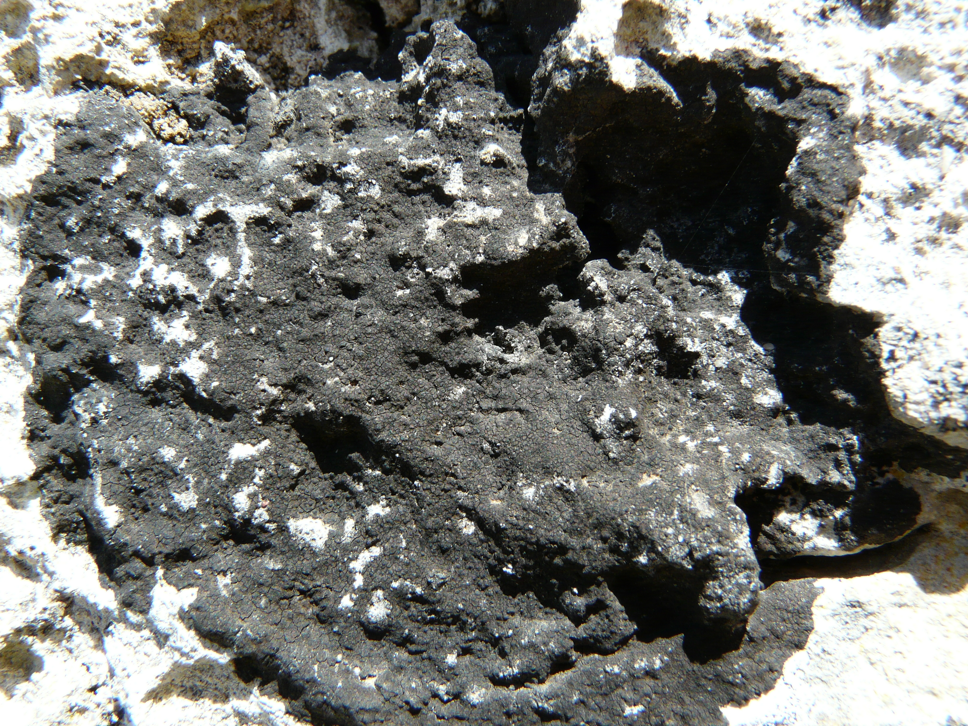
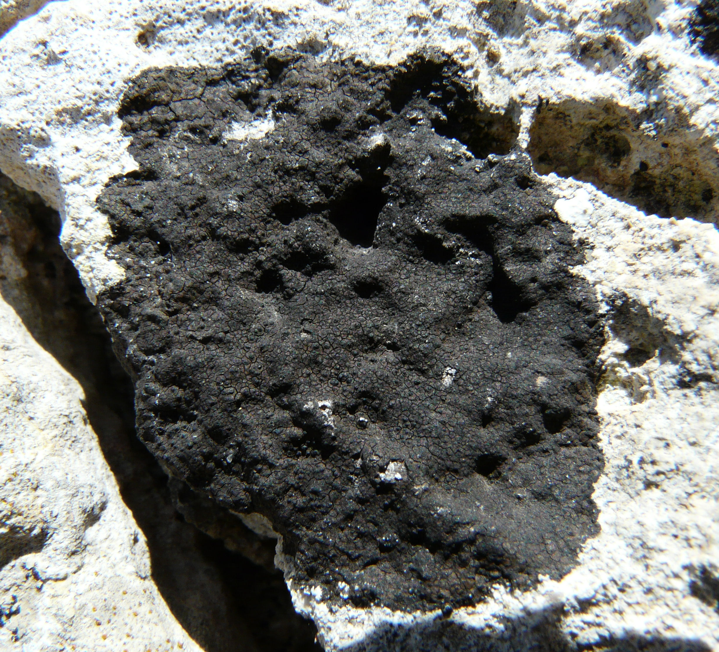
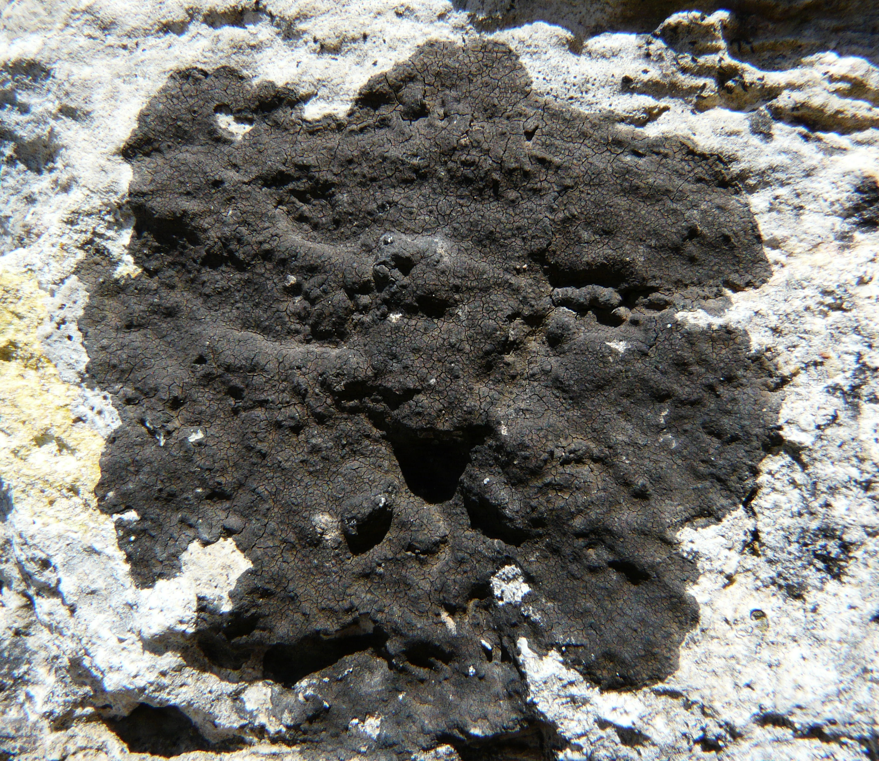
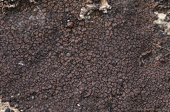
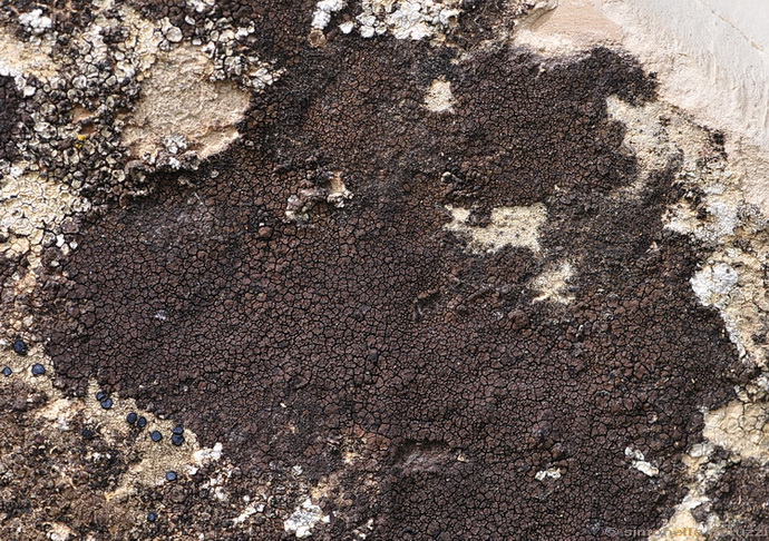
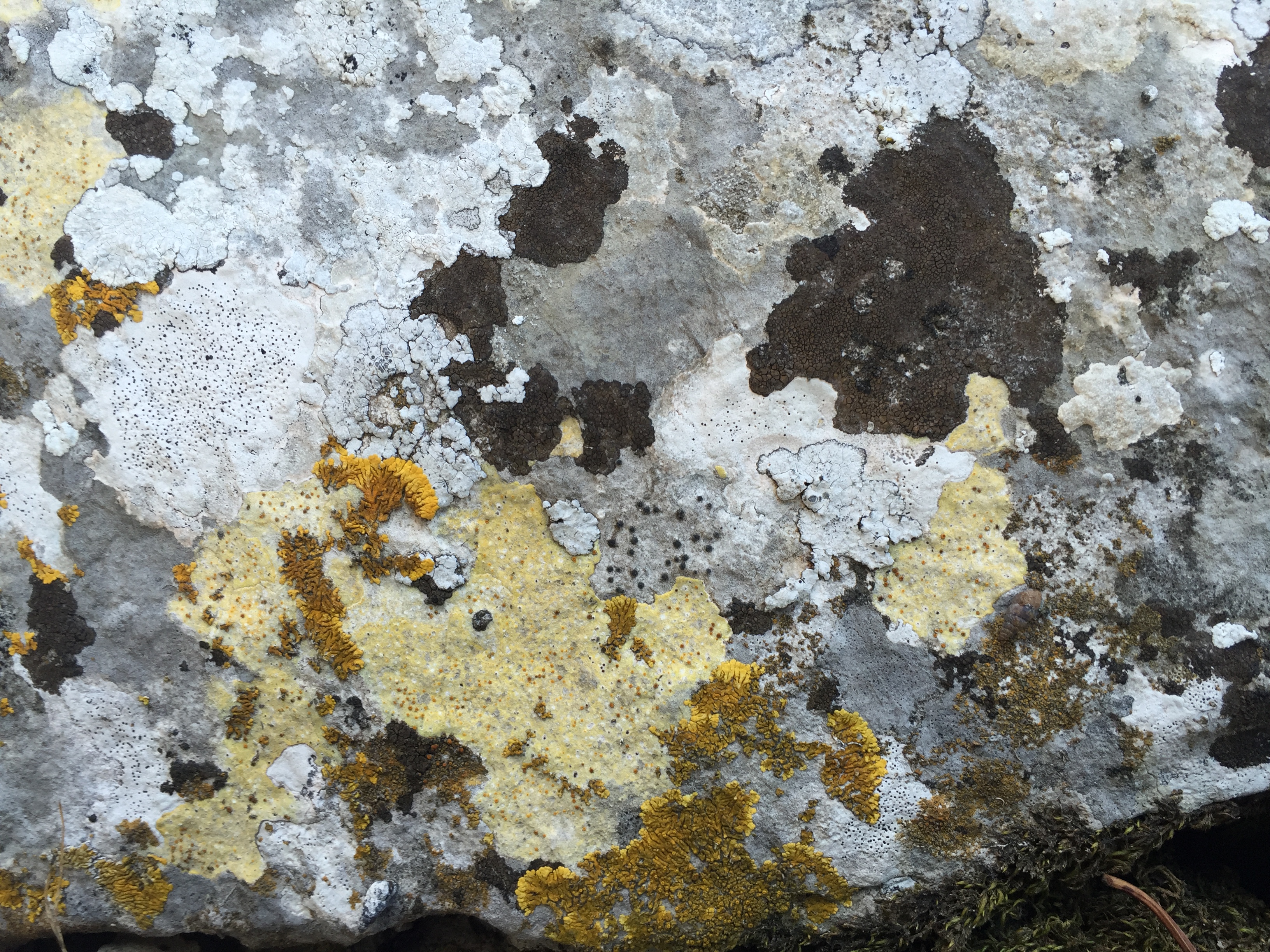
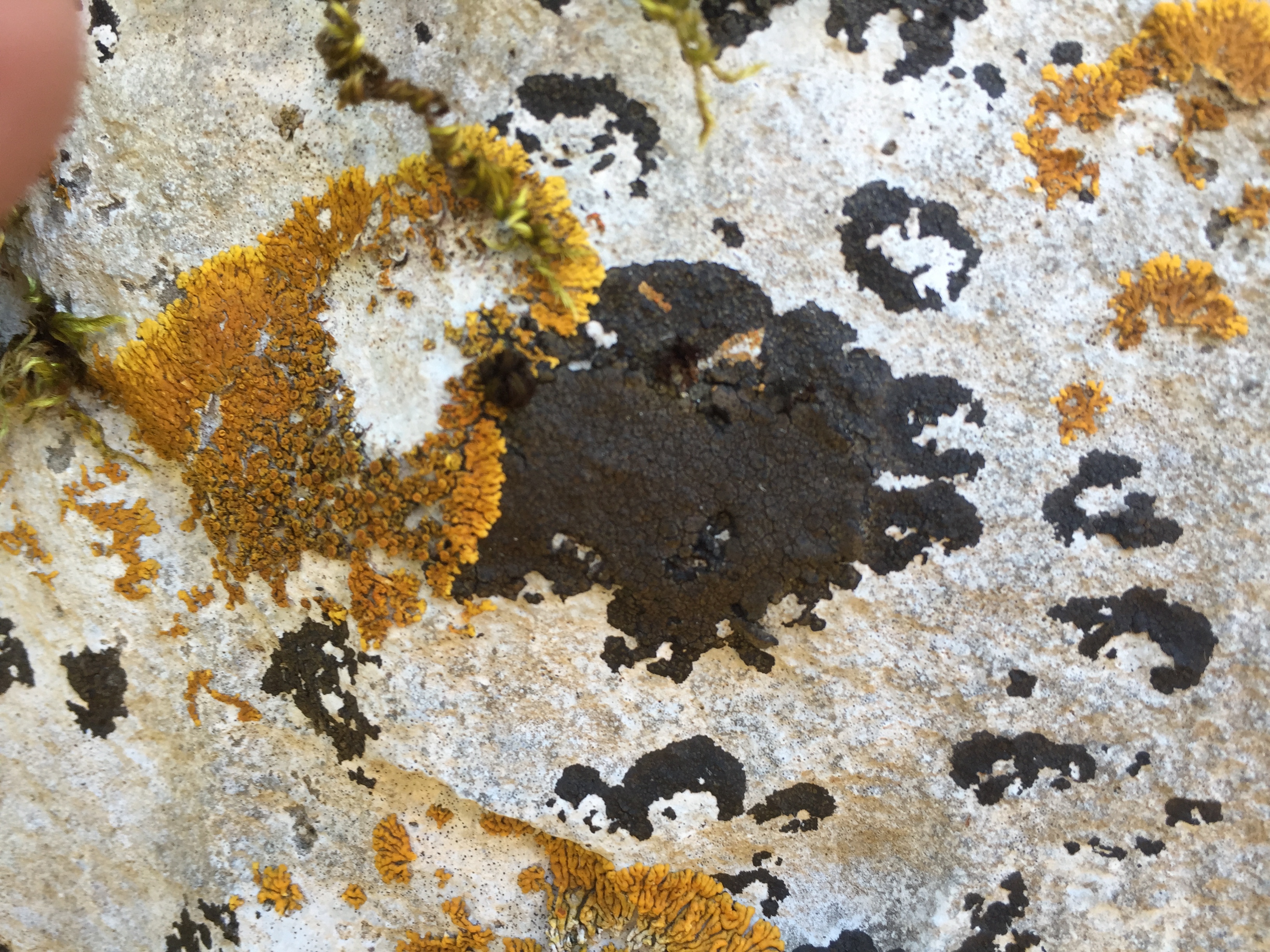
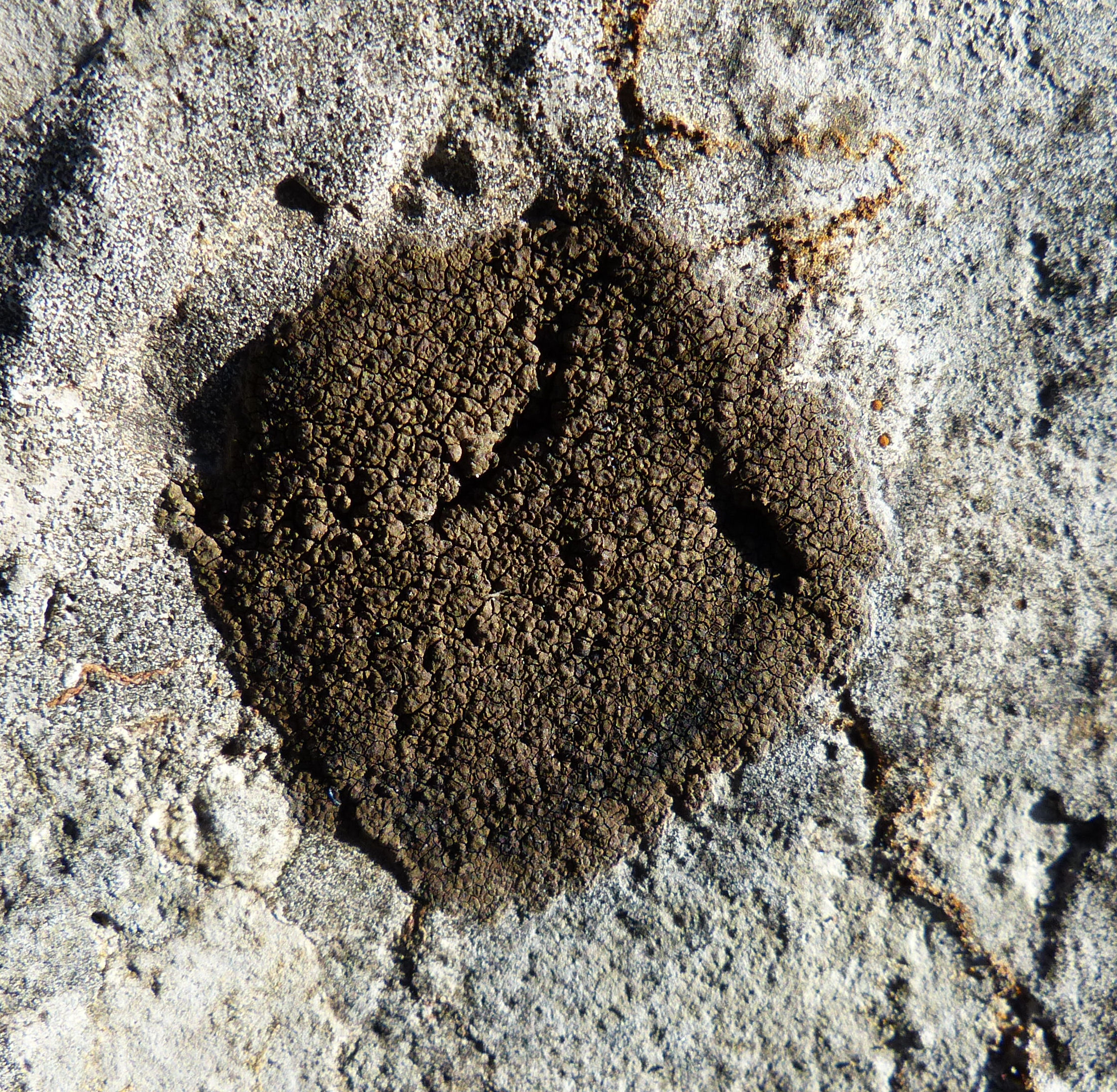
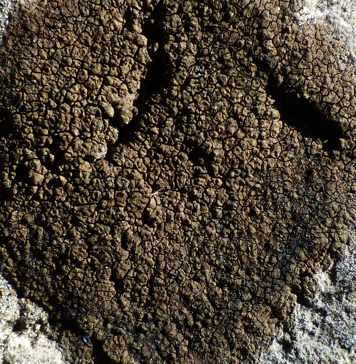
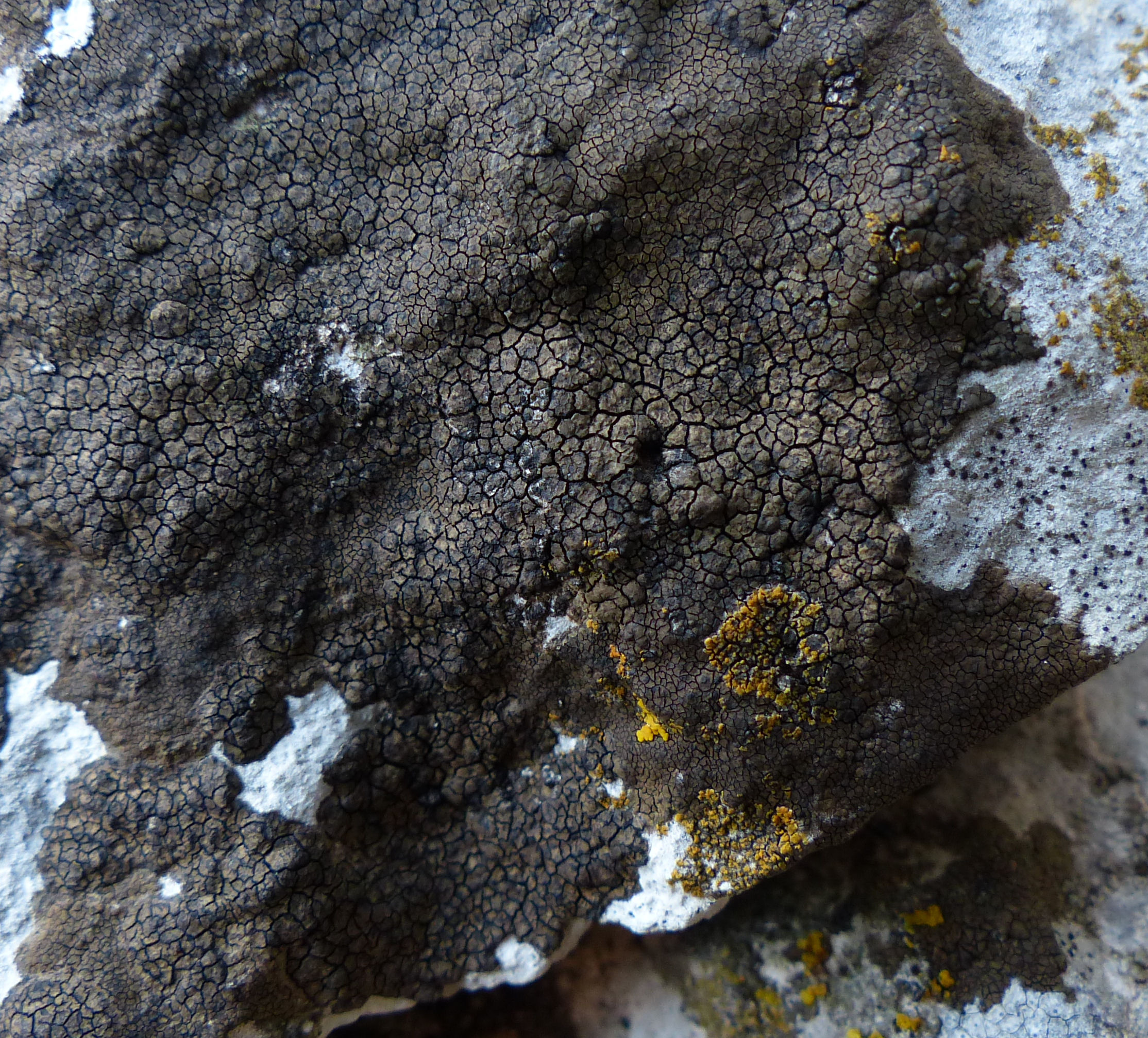
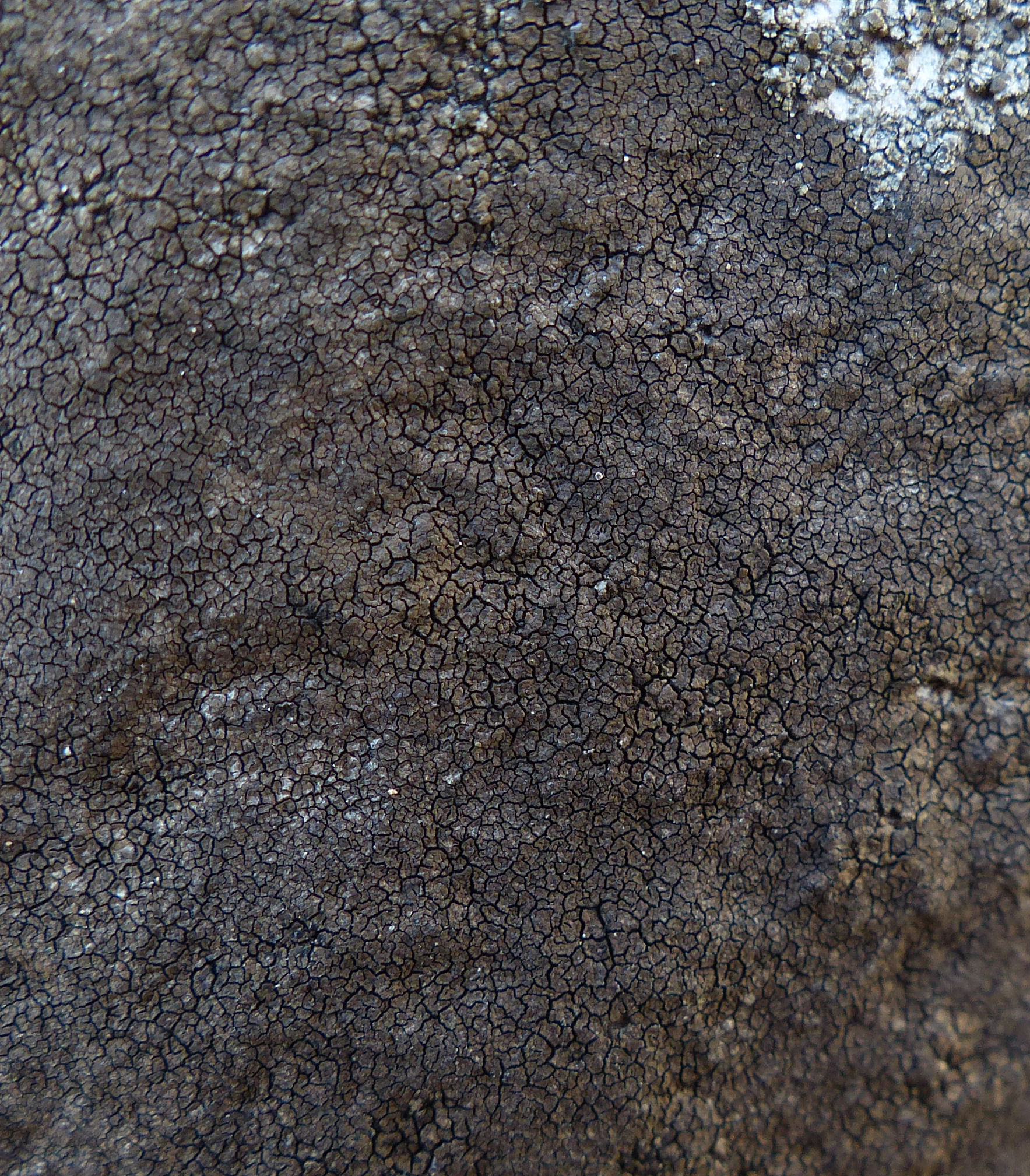
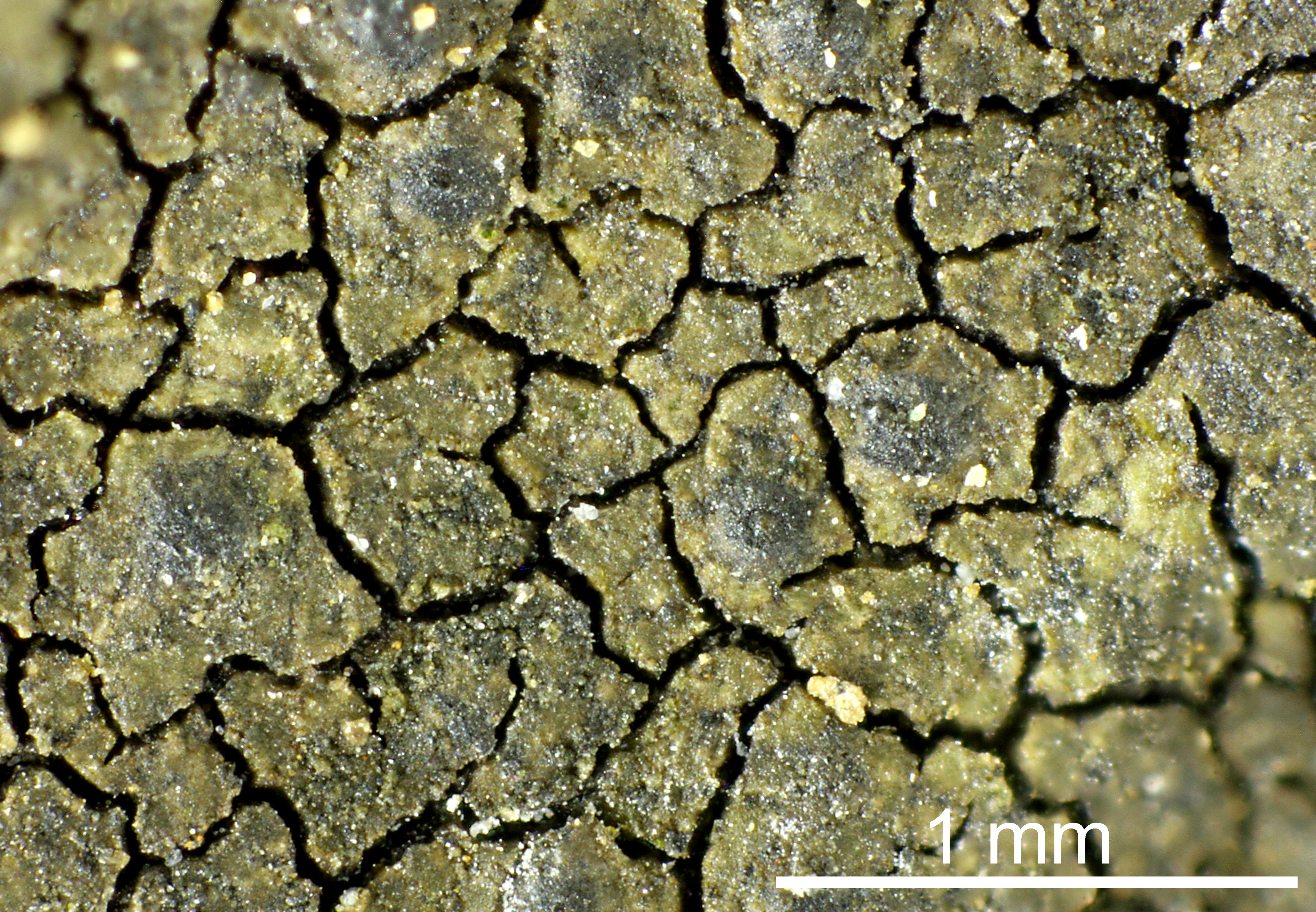
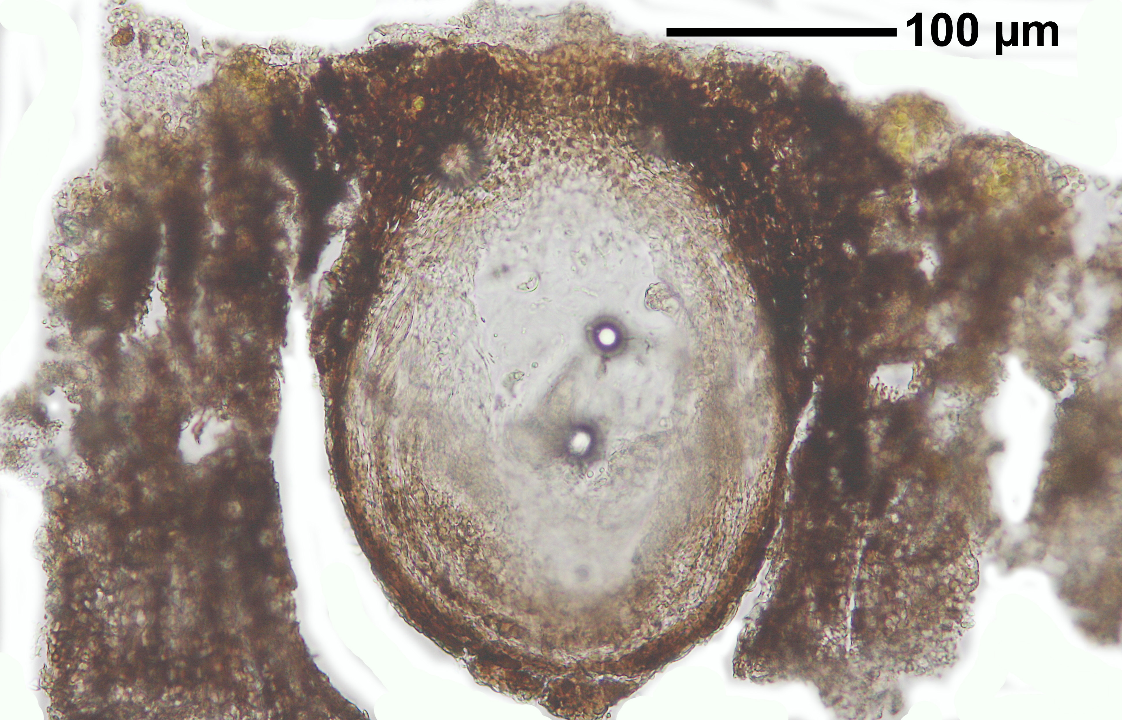
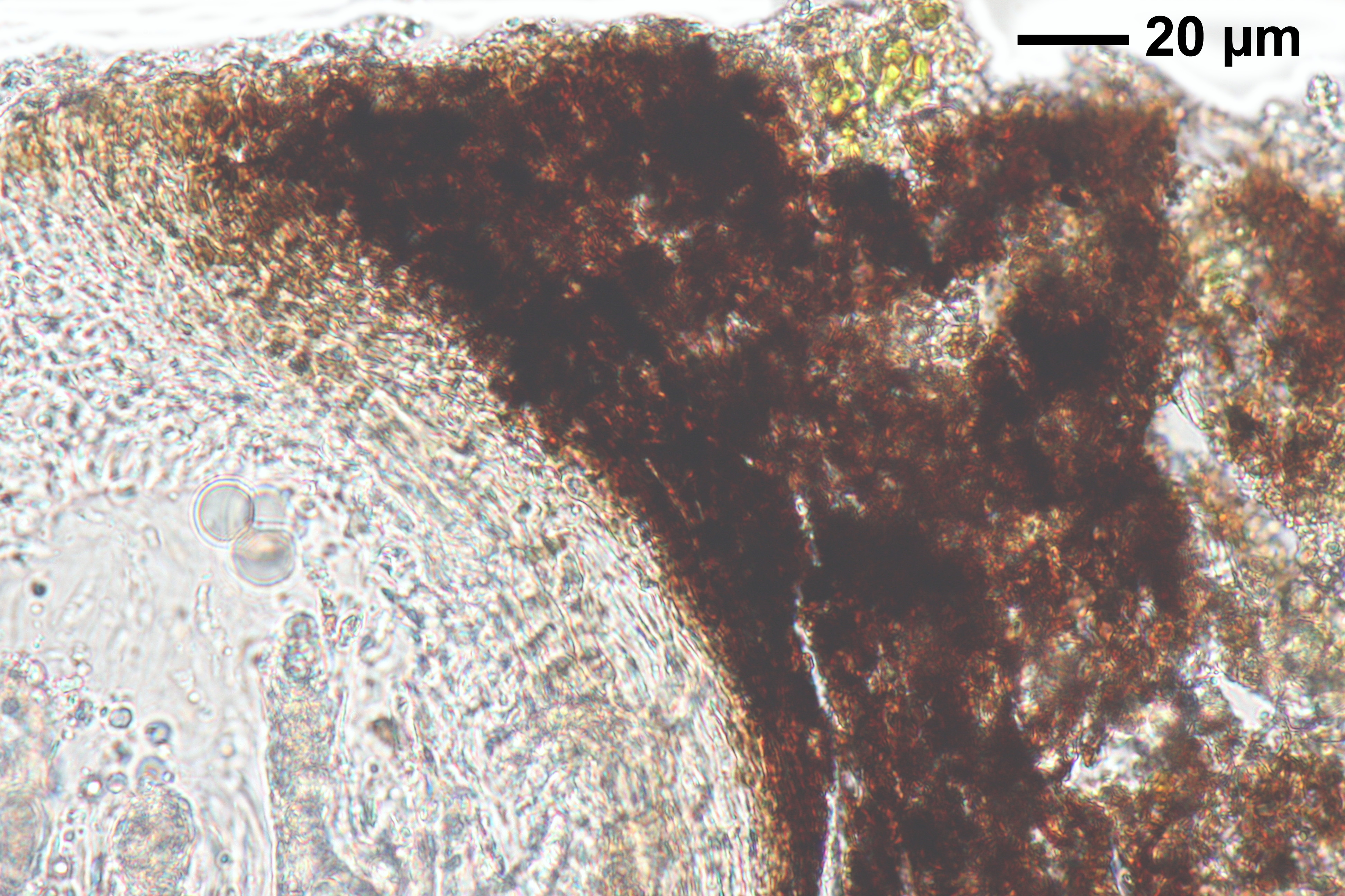
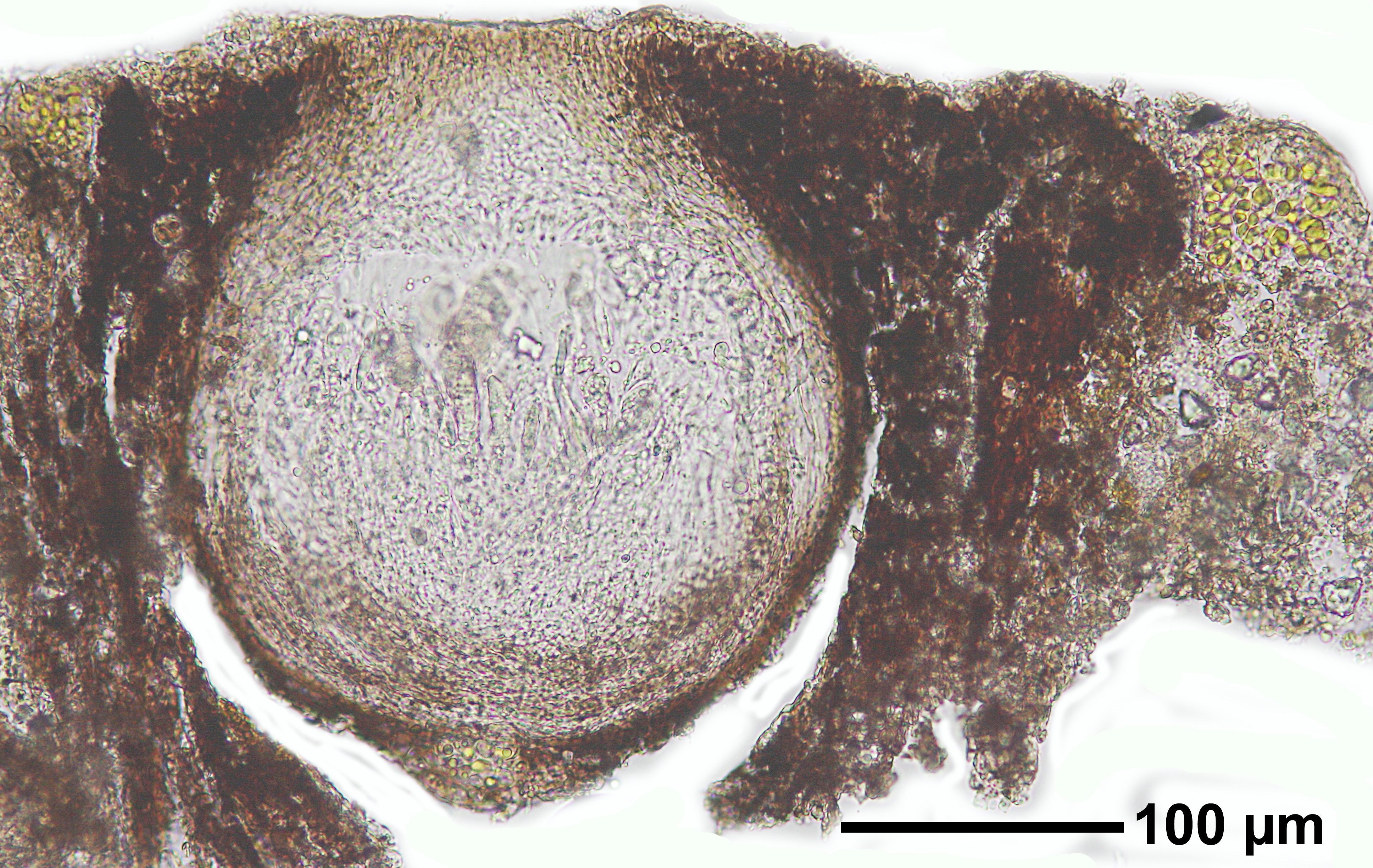
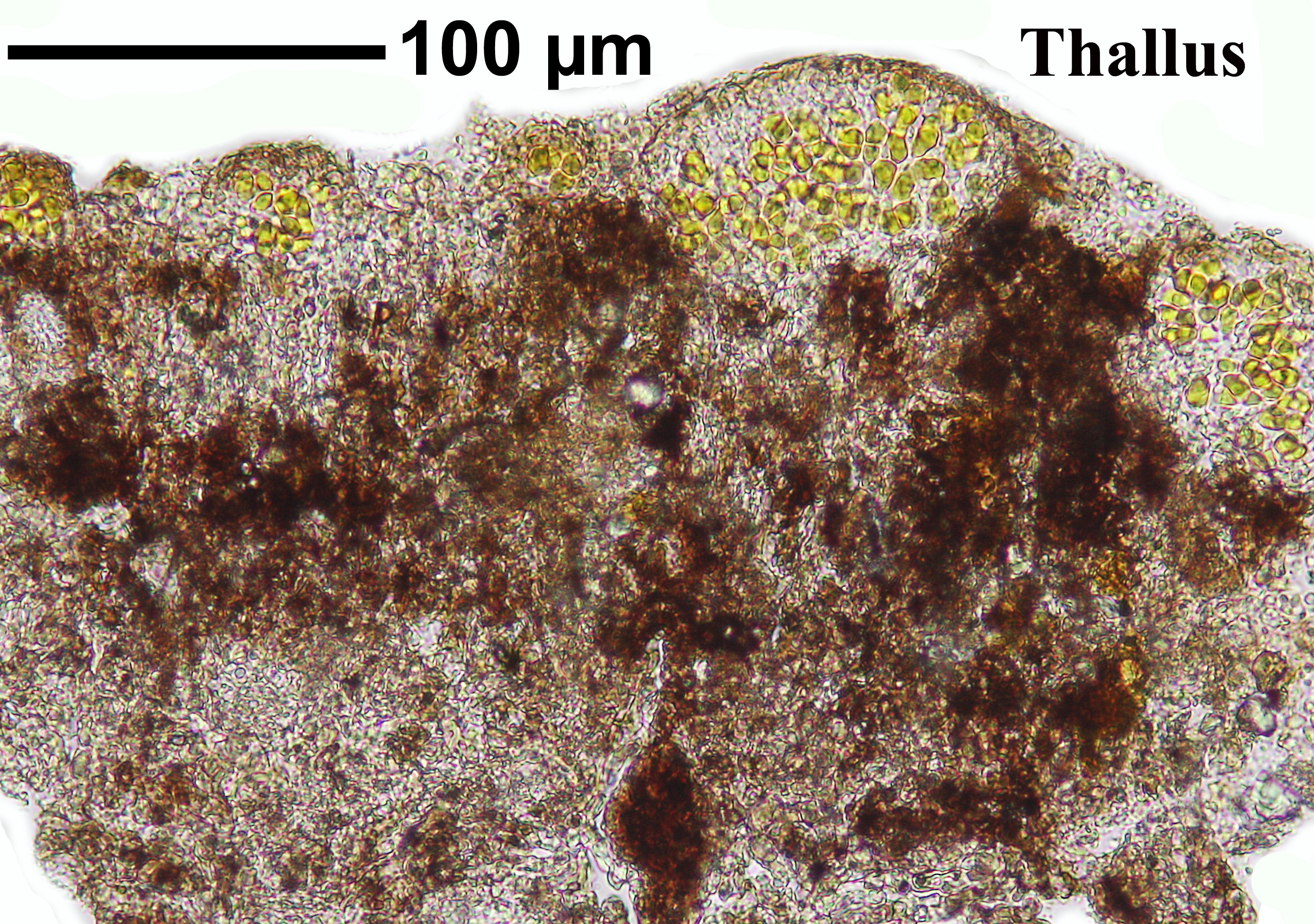
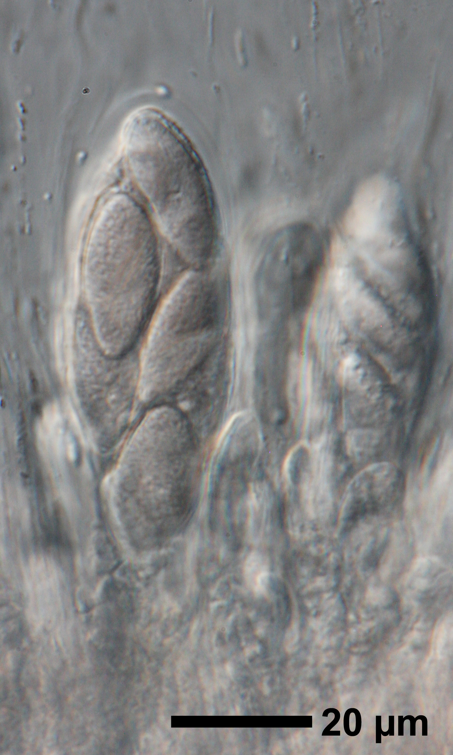
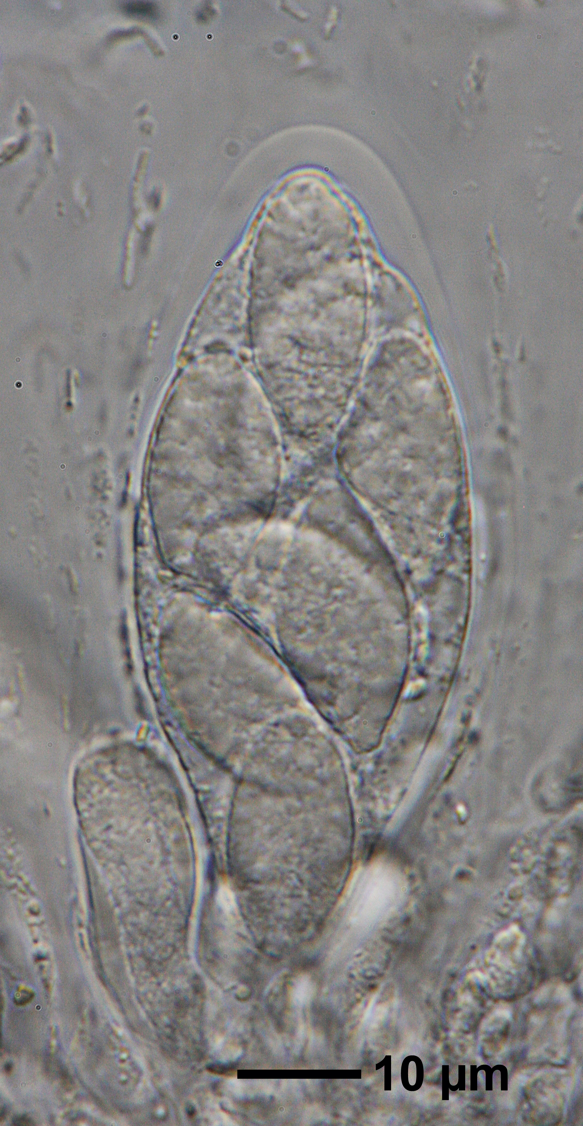
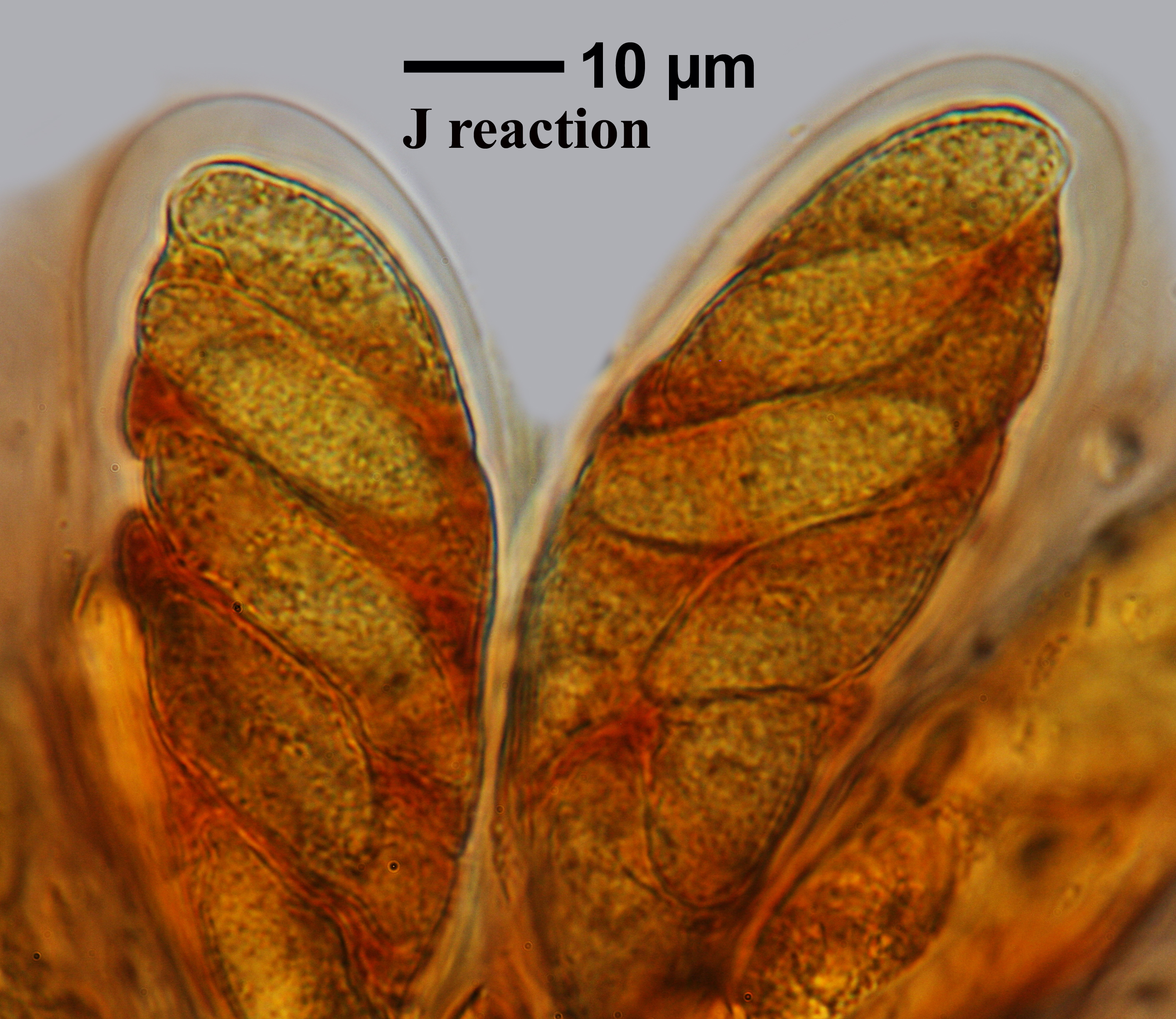
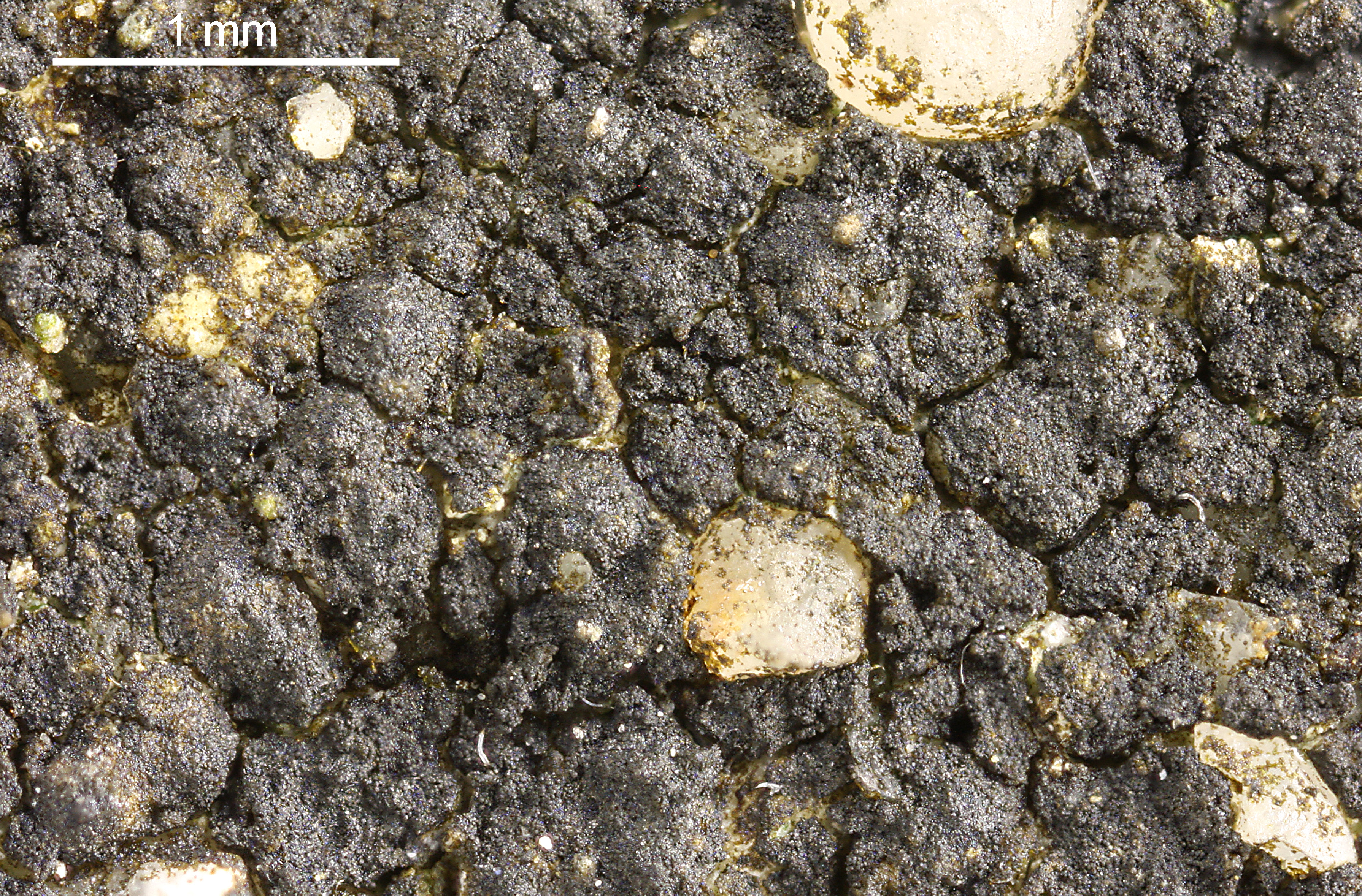
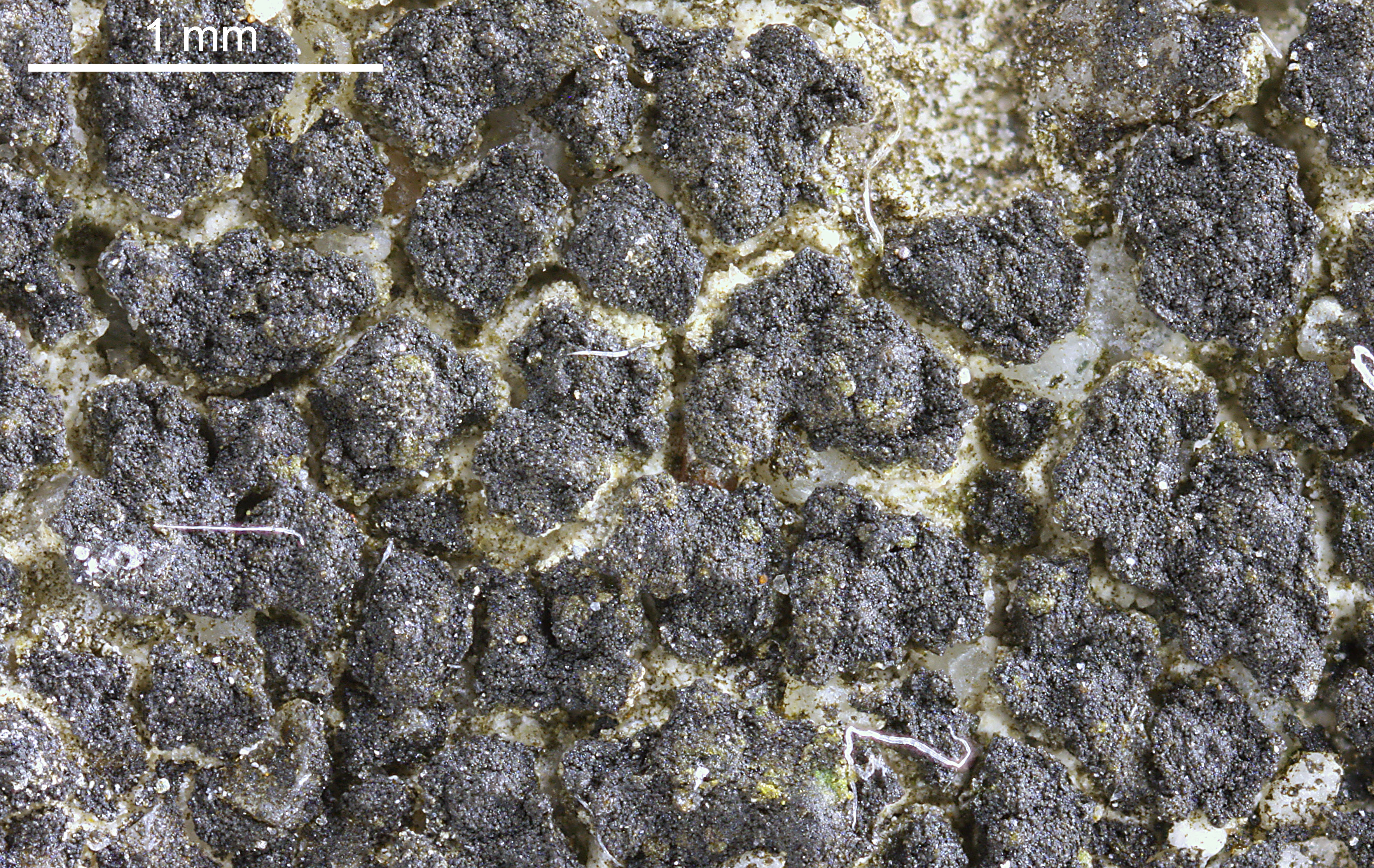
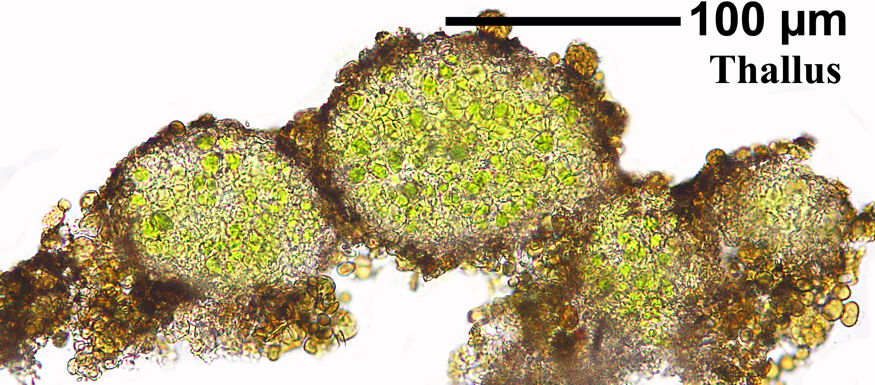
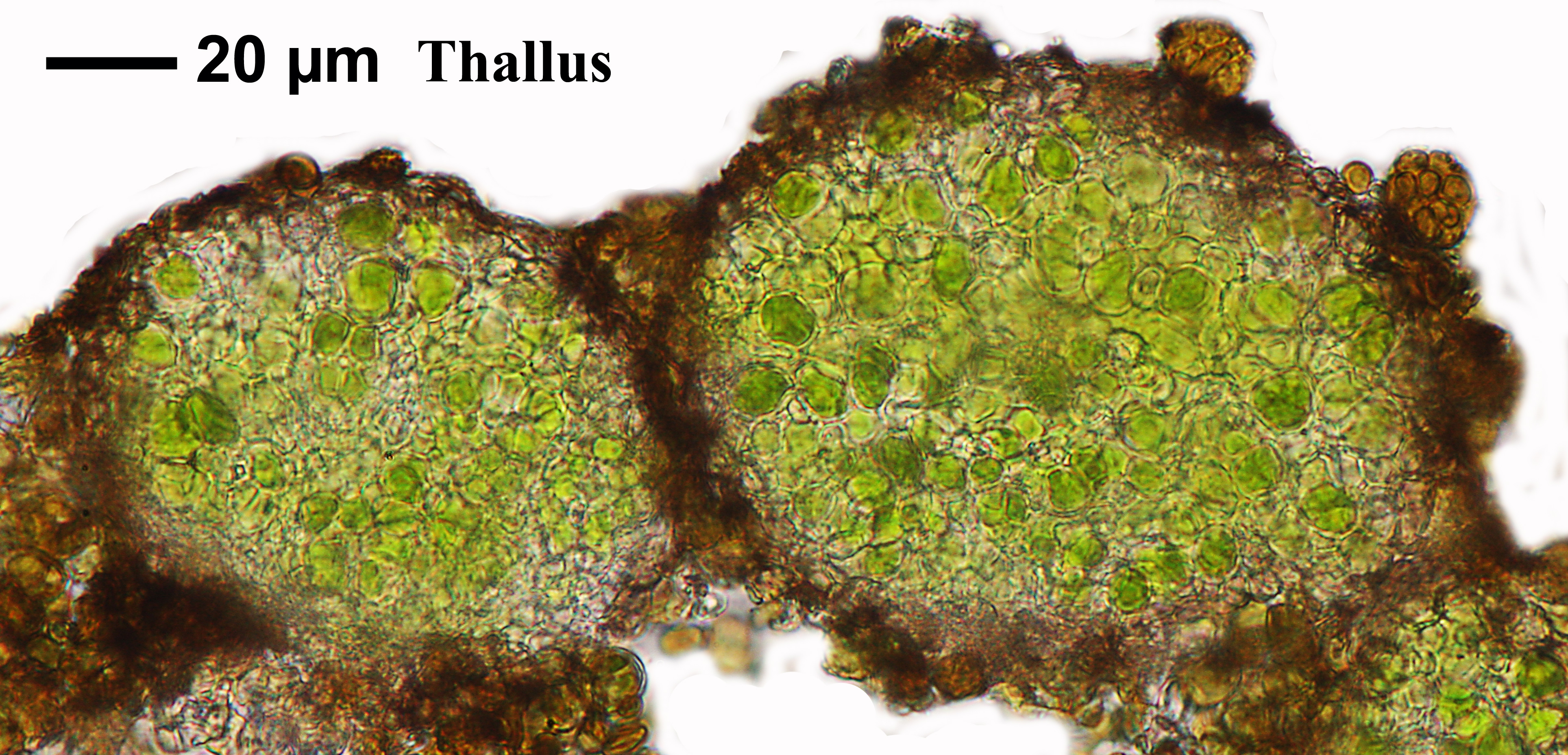
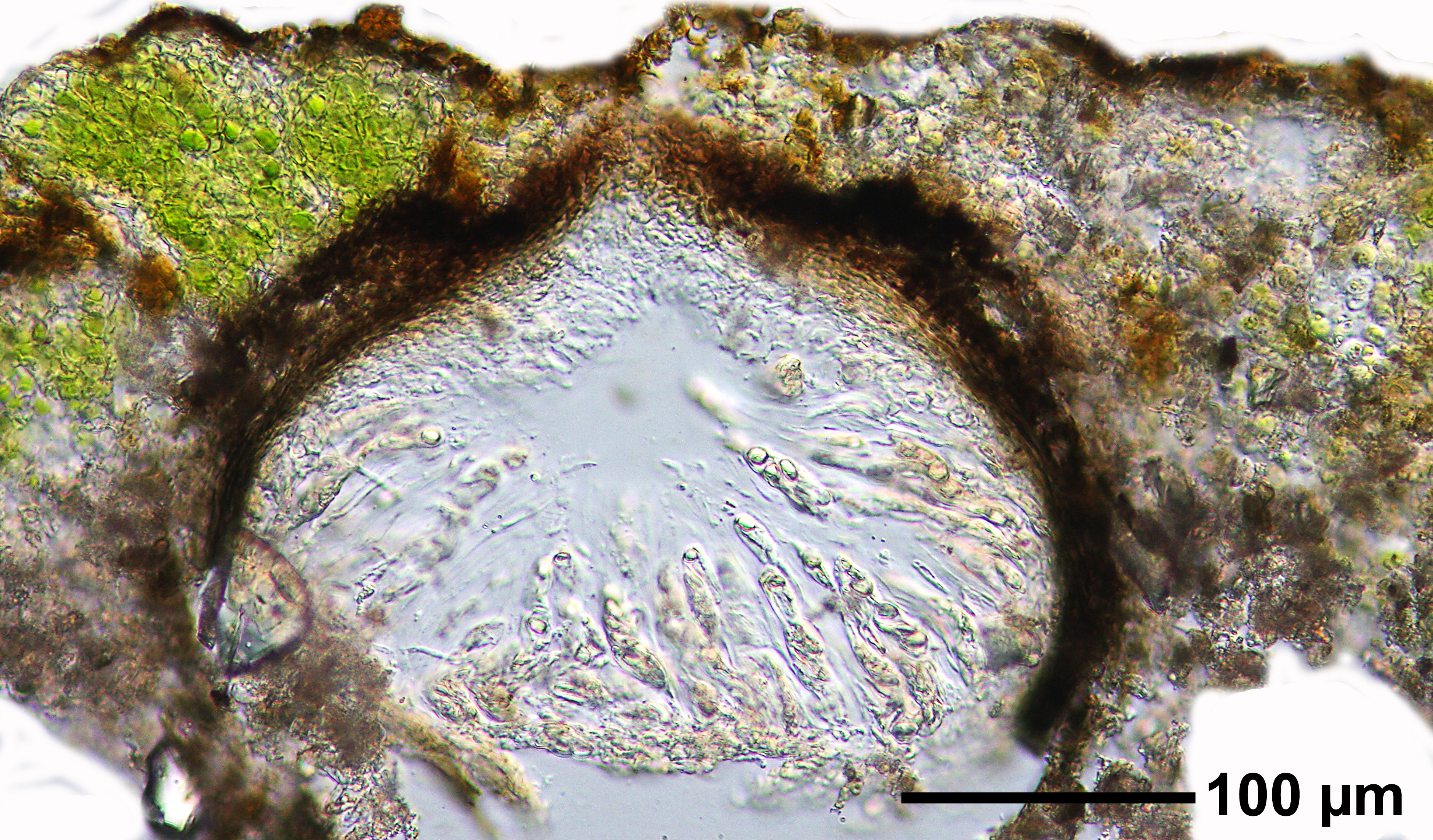
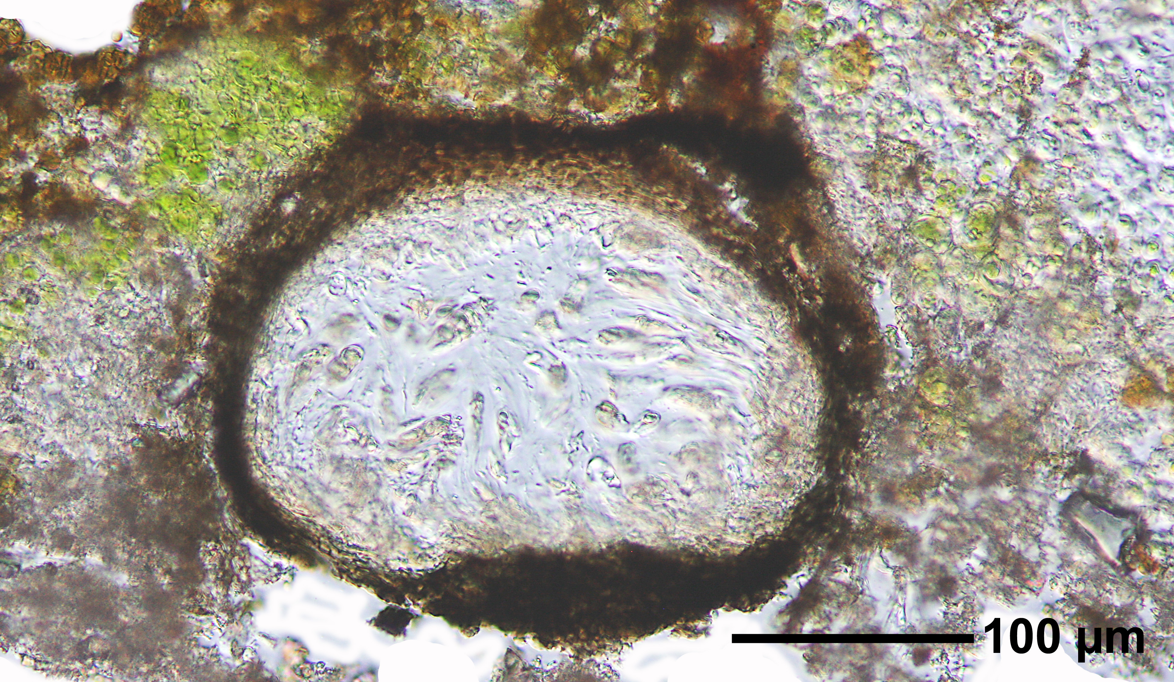
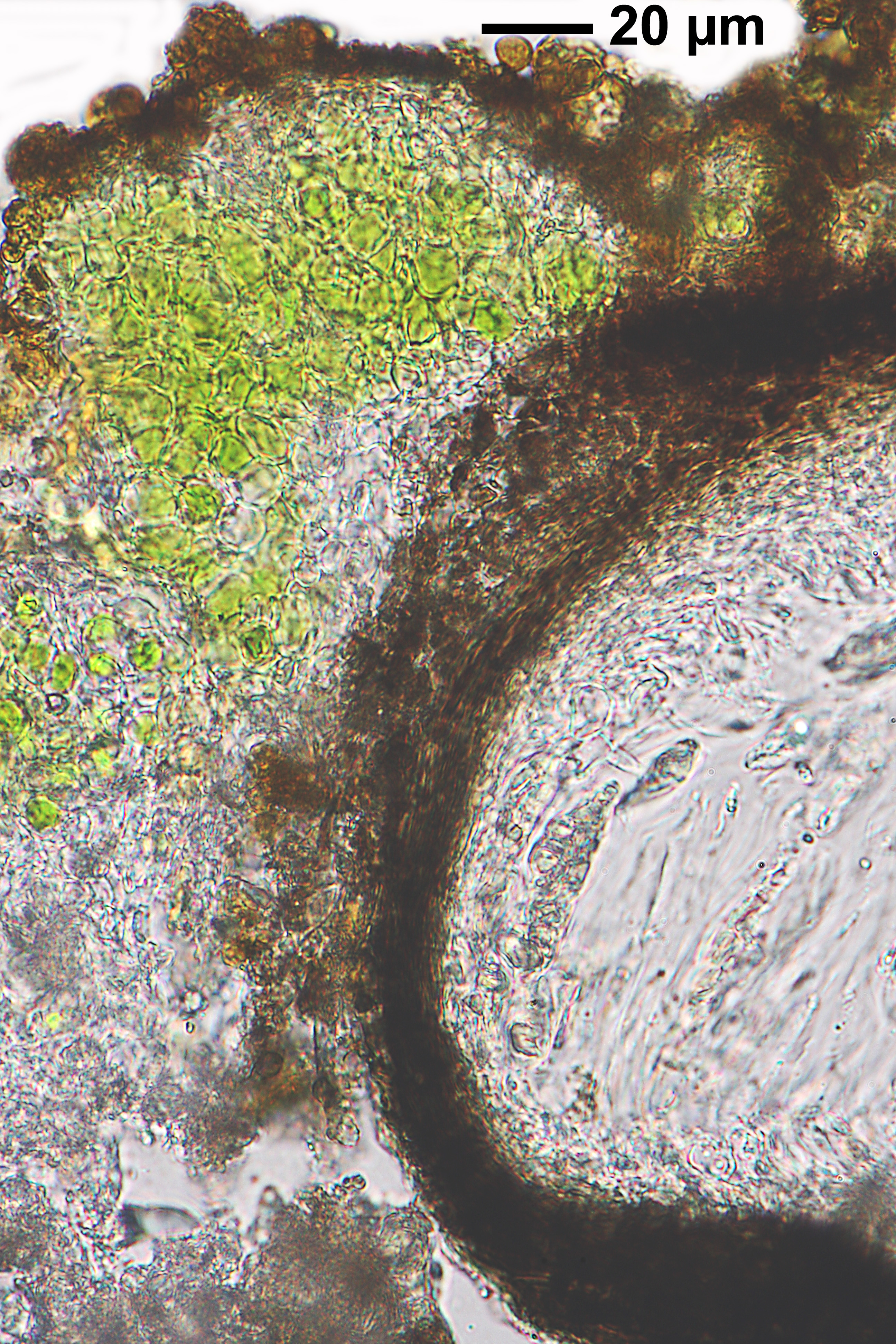
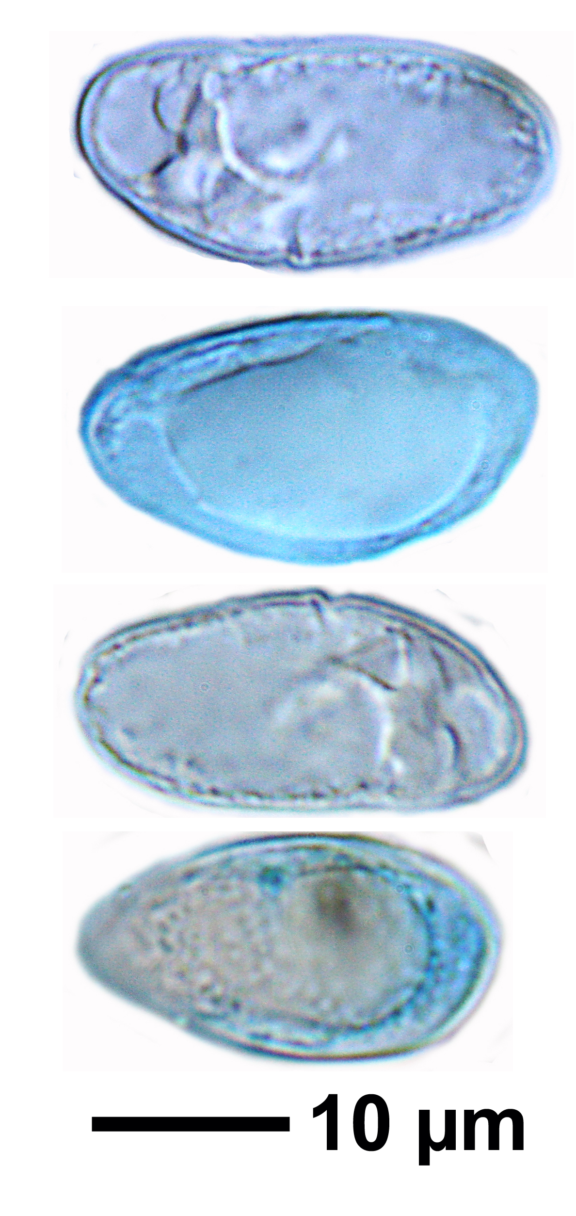
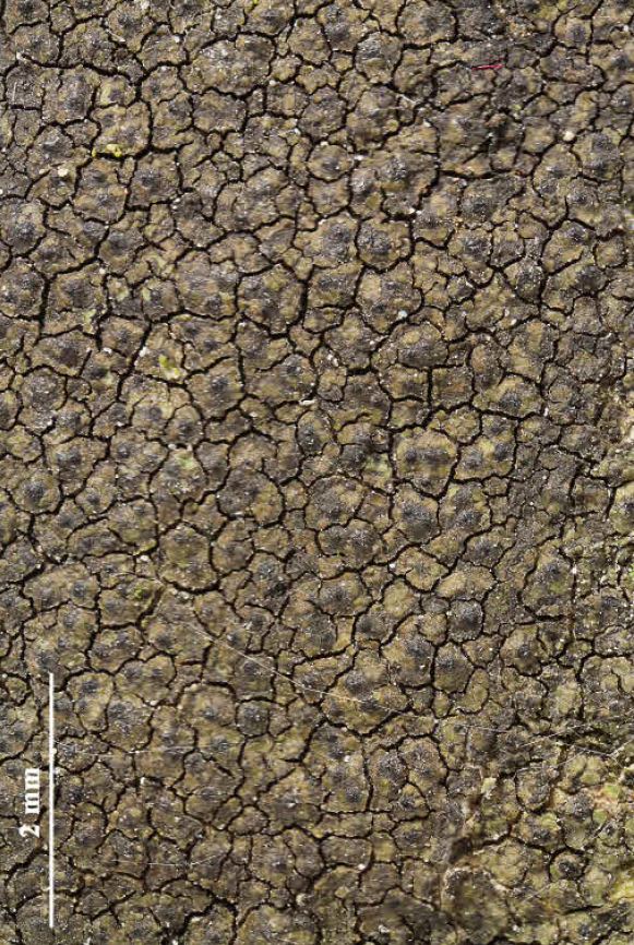
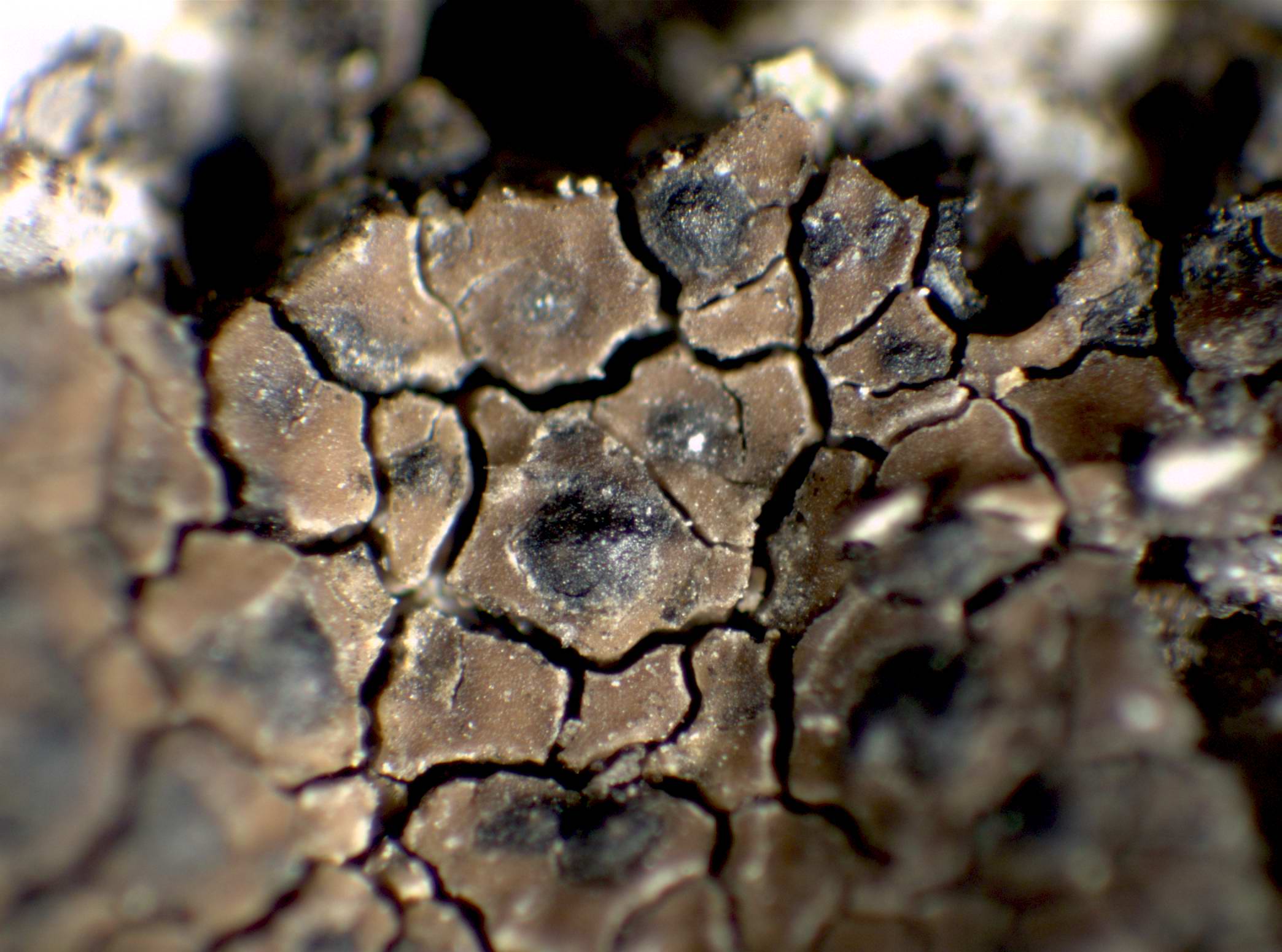
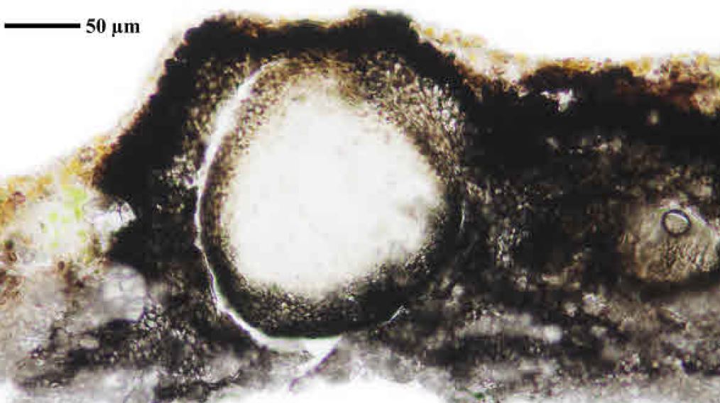
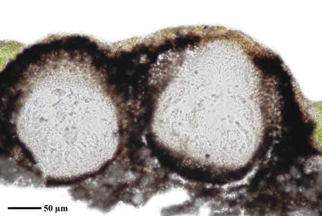
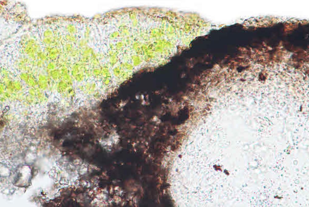
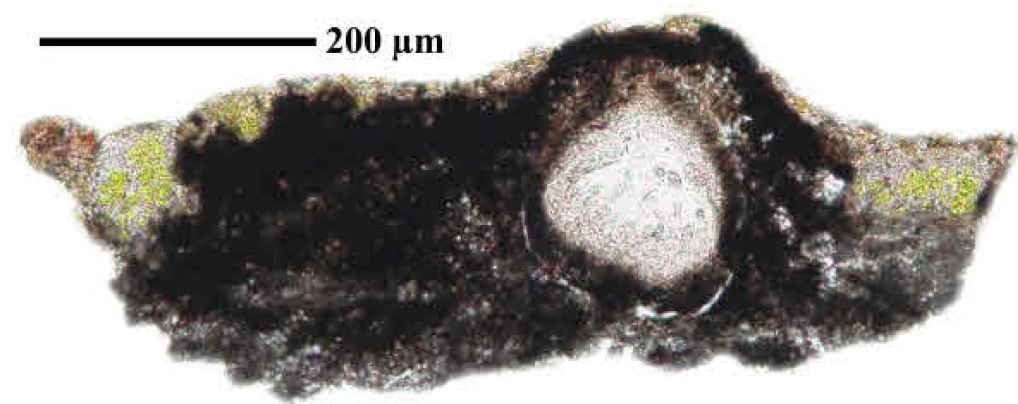
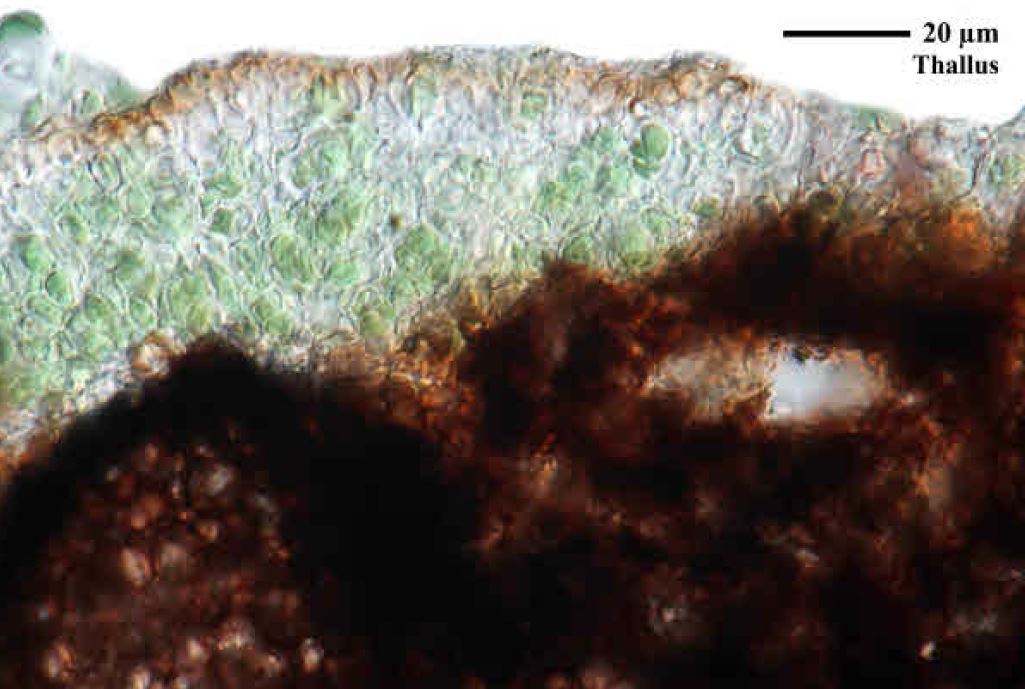
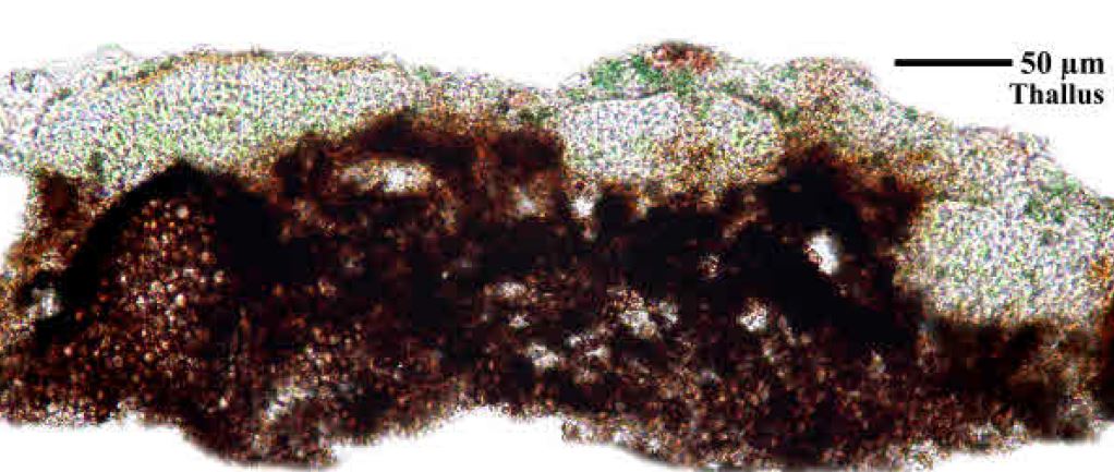
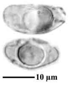
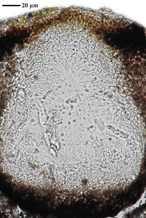
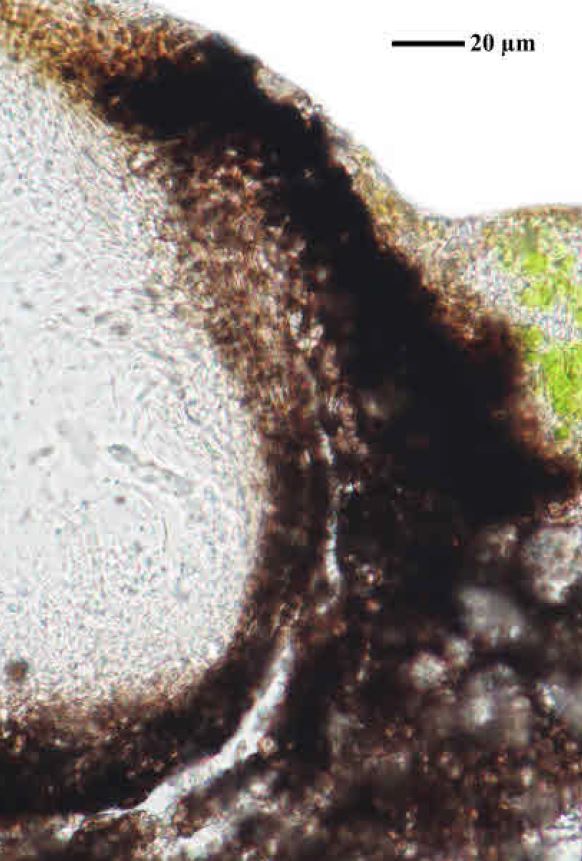
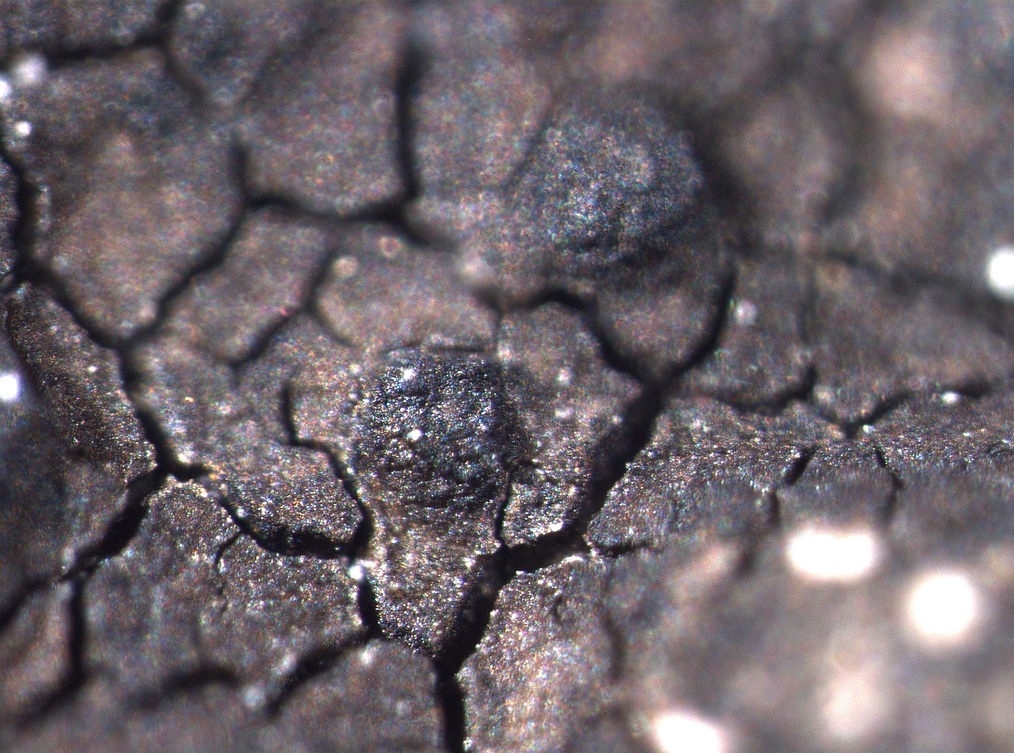
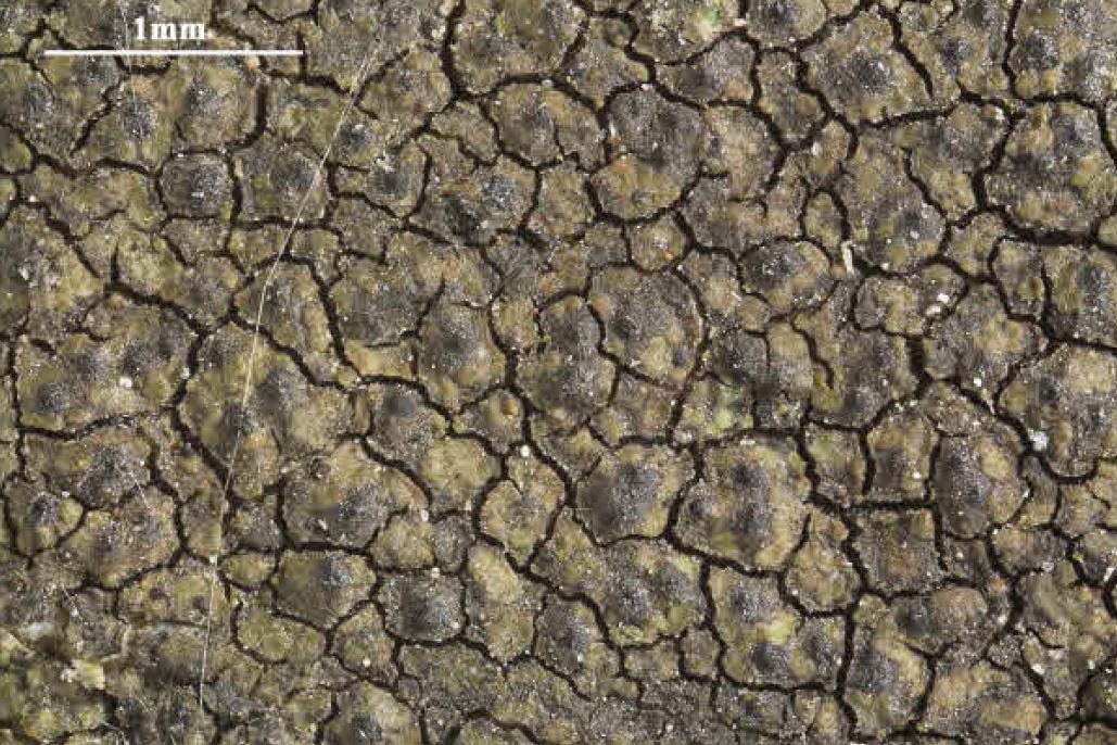
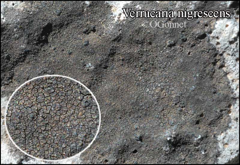
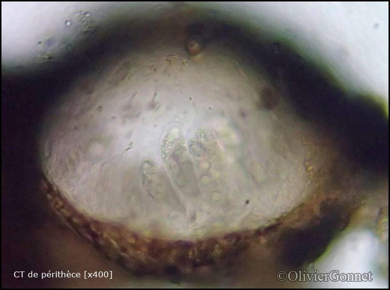
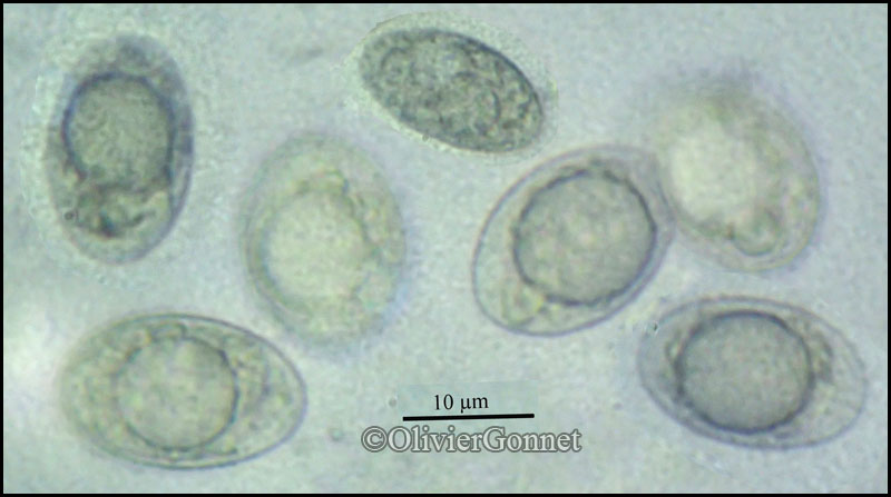
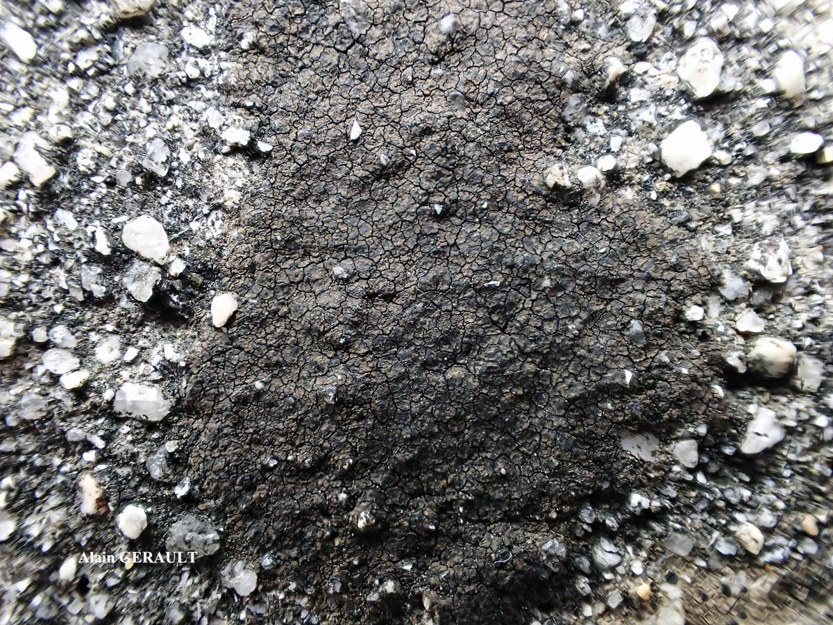
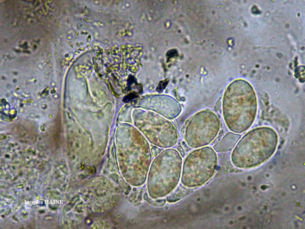
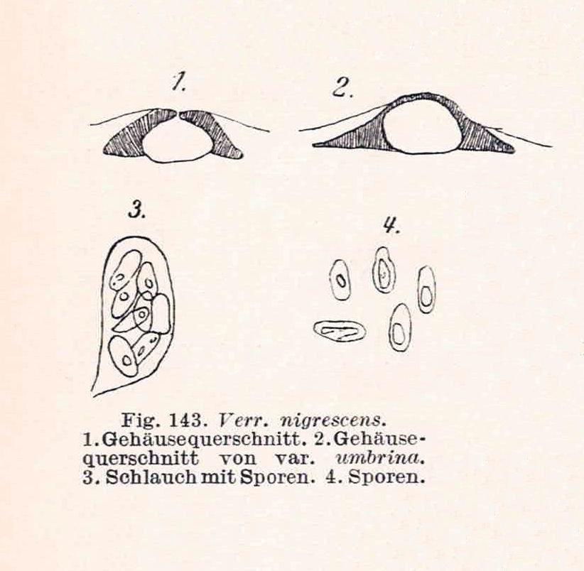
Description: Thallus crustose, episubstratic, cracked-areolate, well-delimited, dark olive-green, dark brown or blackish brown, sometimes almost black, epruinose, 0.1-1.3 mm thick, the areoles 0.2-0.8(-1) mm wide, smooth, flat to slightly convex, often subdivided into smaller units by black lines, sometimes indistinctly blastidiate at margin. Cortex 10-25 µm thick,paraplectenchymatous, of 4-6 µm wide cells, the uppermost ones brown, overlain by a thin epinecral layer; algal layer often interrupted by black columns arising from the medullary basal layer; medulla with a well-developed, carbonaceous black basal layer which occupies 1/3-2/3 of thallus thickness. Perithecia black, 50-70/cm², 1/3 to fully immersed in the areoles, the visible part 0.2-0.25(-0.3) mm across. Involucrellum appressed to exciple, up to 50 µm thick in upper part, extending to base-level and merging with the black basal layer; exciple subglobose, 0.2-0.3 mm across, the wall 15-20 μm thick, black; hamathecium of mostly simple, 25-40 µm long periphysoids, interascal filaments absent; hymenial gel hemiamyloid, I+ red (I+ blue at very low concentrations of I), K/I+ blue. Asci 8-spored, clavate, I-, fissitunicate, the wall thickened above, with an ocular chamber, dehiscent by extrusion of an endotunica to form a delicate rostrum, Verrucaria-type. Ascospores 1-celled, hyaline, ellipsoid, 17-27(-30) x 8-12(-14) µm. Photobiont chlorococcoid. Spot tests: K-, C-, KC-, P-, UV-. Chemistry: without lichen substances.
Growth form: Crustose
Substrata: rocks
Photobiont: green algae other than Trentepohlia
Reproductive strategy: mainly sexual
Pioneer species
Commonnes-rarity: (info)
Alpine belt: rather common
Subalpine belt: common
Montane belt: extremely common
Dry submediterranean belt: extremely common
Humid submediterranean belt: extremely common
Padanian area: common
pH of the substrata:
1 2 3 4 5

Solar irradiation:
1 2 3 4 5
Aridity:
1 2 3 4 5
Eutrophication:
1 2 3 4 5
Poleotolerance:
0 1 2 3
Altitudinal distribution:
1 2 3 4 5 6
Rarity
absent
extremely rare
very rare
rare
rather rare
rather common
common
very common
extremely common
Loading data...
Occurrence data
Predictive map

Felix Schumm CC BY-SA 4.0
[19673], Germany, Baden-Württemberg, Stuttgart-Hohenheim, beim Botanischen Institut, 48.71081° N, 9.20847° E, 394 m, auf kalkhaltigen (HCL+) Quarzkieselsteinen, TK 7221/3.
Leg. et det. F. Schumm, 12.08.2017
P.L. Nimis; Owner: Department of Life Sciences, University of Trieste
Herbarium: TSB (35728)
2003/01/22

A. Moro; Owner: Department of Life Sciences, University of Trieste
Sicilia, TP, Erice, dintorni della città
2008.04.05
A. Moro; Owner: Department of Life Sciences, University of Trieste
Sicilia, TP, Erice, dintorni della città
2008.04.05
A. Moro; Owner: Department of Life Sciences, University of Trieste
Sicilia, TP, Erice, dintorni della città
2008.04.05

Simonetta Peruzzi; Owner: Simonetta Peruzzi
Italy, Toscana, Celle
2010
Simonetta Peruzzi; Owner: Simonetta Peruzzi
Italy, Toscana, Celle
2010
P.L. Nimis; Owner: Department of Life Sciences, University of Trieste
Italy, Friuli Venezia Giulia, Trieste, Trieste Karst, Rocca di Monrupino (Rupingrande)
07.07.2016

P.L. Nimis; Owner: Department of Life Sciences, University of Trieste
Italy, Friuli Venezia Giulia, Trieste, Trieste Karst, Rocca di Monrupino (Rupingrande)
07.07.2016
Andrea Moro; Owner: Department of Life Sciences, University of Trieste
italy, Friuli Venezia Giulia, Trieste, Trieste Karst near Borgo Grotta Gigante
16/02/2017
Andrea Moro; Owner: Department of Life Sciences, University of Trieste
italy, Friuli Venezia Giulia, Trieste, Trieste Karst near Borgo Grotta Gigante
16/02/2017
Andrea Moro; Owner: Department of Life Sciences, University of Trieste
italy, Friuli Venezia Giulia, Trieste, Trieste Karst near Borgo Grotta Gigante
16/02/2017
Andrea Moro; Owner: Department of Life Sciences, University of Trieste
italy, Friuli Venezia Giulia, Trieste, Trieste Karst near Borgo Grotta Gigante
16/02/2017

Andrea Moro; Owner: Department of Life Sciences, University of Triedte
Italy, Friuli Venezia Giulia, Trieste, Trieste Karst, Rocca di Monrupino
20/02/2017
Andrea Moro; Owner: Department of Life Sciences, University of Triedte
Italy, Friuli Venezia Giulia, Trieste, Trieste Karst, Rocca di Monrupino
20/02/2017

Felix Schumm - CC BY-SA 4.0
[16603], Germany, Baden-Württemberg, Schwäbische Alb, Kreis Reutlingen, zwischen Seeburg und Münsingen nahe der Abzweigung nach Rietheim, 48.43164° N, 9.46574° E, 730 m, an Kalkblöcken. Leg. et det. Schumm 14.08.2010, test. A. Aptroot 2011.
Albino Form!

Felix Schumm - CC BY-SA 4.0
[16603], Germany, Baden-Württemberg, Schwäbische Alb, Kreis Reutlingen, zwischen Seeburg und Münsingen nahe der Abzweigung nach Rietheim, 48.43164° N, 9.46574° E, 730 m, an Kalkblöcken. Leg. et det. Schumm 14.08.2010, test. A. Aptroot 2011.
Felix Schumm - CC BY-SA 4.0
[16603], Germany, Baden-Württemberg, Schwäbische Alb, Kreis Reutlingen, zwischen Seeburg und Münsingen nahe der Abzweigung nach Rietheim, 48.43164° N, 9.46574° E, 730 m, an Kalkblöcken. Leg. et det. Schumm 14.08.2010, test. A. Aptroot 2011.
Felix Schumm - CC BY-SA 4.0
[16603], Germany, Baden-Württemberg, Schwäbische Alb, Kreis Reutlingen, zwischen Seeburg und Münsingen nahe der Abzweigung nach Rietheim, 48.43164° N, 9.46574° E, 730 m, an Kalkblöcken. Leg. et det. Schumm 14.08.2010, test. A. Aptroot 2011.
Felix Schumm - CC BY-SA 4.0
[16603], Germany, Baden-Württemberg, Schwäbische Alb, Kreis Reutlingen, zwischen Seeburg und Münsingen nahe der Abzweigung nach Rietheim, 48.43164° N, 9.46574° E, 730 m, an Kalkblöcken. Leg. et det. Schumm 14.08.2010, test. A. Aptroot 2011.
Felix Schumm - CC BY-SA 4.0
[16603], Germany, Baden-Württemberg, Schwäbische Alb, Kreis Reutlingen, zwischen Seeburg und Münsingen nahe der Abzweigung nach Rietheim, 48.43164° N, 9.46574° E, 730 m, an Kalkblöcken. Leg. et det. Schumm 14.08.2010, test. A. Aptroot 2011.

Felix Schumm - CC BY-SA 4.0
[16603], Germany, Baden-Württemberg, Schwäbische Alb, Kreis Reutlingen, zwischen Seeburg und Münsingen nahe der Abzweigung nach Rietheim, 48.43164° N, 9.46574° E, 730 m, an Kalkblöcken. Leg. et det. Schumm 14.08.2010, test. A. Aptroot 2011.
Felix Schumm - CC BY-SA 4.0
[16603], Germany, Baden-Württemberg, Schwäbische Alb, Kreis Reutlingen, zwischen Seeburg und Münsingen nahe der Abzweigung nach Rietheim, 48.43164° N, 9.46574° E, 730 m, an Kalkblöcken. Leg. et det. Schumm 14.08.2010, test. A. Aptroot 2011.

Felix Schumm - CC BY-SA 4.0
[16603], Germany, Baden-Württemberg, Schwäbische Alb, Kreis Reutlingen, zwischen Seeburg und Münsingen nahe der Abzweigung nach Rietheim, 48.43164° N, 9.46574° E, 730 m, an Kalkblöcken. Leg. et det. Schumm 14.08.2010, test. A. Aptroot 2011.
Felix Schumm - CC BY-SA 4.0
[16603], Germany, Baden-Württemberg, Schwäbische Alb, Kreis Reutlingen, zwischen Seeburg und Münsingen nahe der Abzweigung nach Rietheim, 48.43164° N, 9.46574° E, 730 m, an Kalkblöcken. Leg. et det. Schumm 14.08.2010, test. A. Aptroot 2011.
Felix Schumm - CC BY-SA 4.0
[16603], Germany, Baden-Württemberg, Schwäbische Alb, Kreis Reutlingen, zwischen Seeburg und Münsingen nahe der Abzweigung nach Rietheim, 48.43164° N, 9.46574° E, 730 m, an Kalkblöcken. Leg. et det. Schumm 14.08.2010, test. A. Aptroot 2011.
Felix Schumm - CC BY-SA 4.0
[16603], Germany, Baden-Württemberg, Schwäbische Alb, Kreis Reutlingen, zwischen Seeburg und Münsingen nahe der Abzweigung nach Rietheim, 48.43164° N, 9.46574° E, 730 m, an Kalkblöcken. Leg. et det. Schumm 14.08.2010, test. A. Aptroot 2011.
Felix Schumm - CC BY-SA 4.0
[16603], Germany, Baden-Württemberg, Schwäbische Alb, Kreis Reutlingen, zwischen Seeburg und Münsingen nahe der Abzweigung nach Rietheim, 48.43164° N, 9.46574° E, 730 m, an Kalkblöcken. Leg. et det. Schumm 14.08.2010, test. A. Aptroot 2011.

Felix Schumm - CC BY-SA 4.0
[16603], Germany, Baden-Württemberg, Schwäbische Alb, Kreis Reutlingen, zwischen Seeburg und Münsingen nahe der Abzweigung nach Rietheim, 48.43164° N, 9.46574° E, 730 m, an Kalkblöcken. Leg. et det. Schumm 14.08.2010, test. A. Aptroot 2011.
Felix Schumm - CC BY-SA 4.0
[16708], Germany, Baden-Württemberg, Kreis Göppingen, zwischen Wangen und Unterberken, ehemaliges Militärdepot, auf verwitternden, kleinen Betonmauern, 48.75052° N, 9.57469° E, 480 m. Leg. et det. Schumm 10.10.2010, test. A.Aptroot 2011.

Felix Schumm - CC BY-SA 4.0
[16708], Germany, Baden-Württemberg, Kreis Göppingen, zwischen Wangen und Unterberken, ehemaliges Militärdepot, auf verwitternden, kleinen Betonmauern, 48.75052° N, 9.57469° E, 480 m. Leg. et det. Schumm 10.10.2010, test. A.Aptroot 2011.
Felix Schumm - CC BY-SA 4.0
[16708], Germany, Baden-Württemberg, Kreis Göppingen, zwischen Wangen und Unterberken, ehemaliges Militärdepot, auf verwitternden, kleinen Betonmauern, 48.75052° N, 9.57469° E, 480 m. Leg. et det. Schumm 10.10.2010, test. A.Aptroot 2011.

Felix Schumm - CC BY-SA 4.0
[16708], Germany, Baden-Württemberg, Kreis Göppingen, zwischen Wangen und Unterberken, ehemaliges Militärdepot, auf verwitternden, kleinen Betonmauern, 48.75052° N, 9.57469° E, 480 m. Leg. et det. Schumm 10.10.2010, test. A.Aptroot 2011.
Felix Schumm - CC BY-SA 4.0
[16708], Germany, Baden-Württemberg, Kreis Göppingen, zwischen Wangen und Unterberken, ehemaliges Militärdepot, auf verwitternden, kleinen Betonmauern, 48.75052° N, 9.57469° E, 480 m. Leg. et det. Schumm 10.10.2010, test. A.Aptroot 2011.

Felix Schumm - CC BY-SA 4.0
[16708], Germany, Baden-Württemberg, Kreis Göppingen, zwischen Wangen und Unterberken, ehemaliges Militärdepot, auf verwitternden, kleinen Betonmauern, 48.75052° N, 9.57469° E, 480 m. Leg. et det. Schumm 10.10.2010, test. A.Aptroot 2011.
Felix Schumm - CC BY-SA 4.0
[16708], Germany, Baden-Württemberg, Kreis Göppingen, zwischen Wangen und Unterberken, ehemaliges Militärdepot, auf verwitternden, kleinen Betonmauern, 48.75052° N, 9.57469° E, 480 m. Leg. et det. Schumm 10.10.2010, test. A.Aptroot 2011.

Felix Schumm - CC BY-SA 4.0
[16708], Germany, Baden-Württemberg, Kreis Göppingen, zwischen Wangen und Unterberken, ehemaliges Militärdepot, auf verwitternden, kleinen Betonmauern, 48.75052° N, 9.57469° E, 480 m. Leg. et det. Schumm 10.10.2010, test. A.Aptroot 2011.

Felix Schumm - CC BY-SA 4.0
[16708], Germany, Baden-Württemberg, Kreis Göppingen, zwischen Wangen und Unterberken, ehemaliges Militärdepot, auf verwitternden, kleinen Betonmauern, 48.75052° N, 9.57469° E, 480 m. Leg. et det. Schumm 10.10.2010, test. A.Aptroot 2011.
Felix Schumm - CC BY-SA 4.0
[16708], Germany, Baden-Württemberg, Kreis Göppingen, zwischen Wangen und Unterberken, ehemaliges Militärdepot, auf verwitternden, kleinen Betonmauern, 48.75052° N, 9.57469° E, 480 m. Leg. et det. Schumm 10.10.2010, test. A.Aptroot 2011.

Felix Schumm – CC BY-SA 4.0
[19673], Germany, Baden-Württemberg, Stuttgart-Hohenheim, beim Botanischen Institut, 48.71081° N, 9.20847° E, 394 m, auf kalkhaltigen (HCL+) Quarzkieselsteinen, TK 7221/3. Leg. et det. F. Schumm, 12.08.2017
P.L. Nimis; Owner: Department of Life Sciences, University of Trieste
Herbarium: TSB (11817)
2001/12/03
Felix Schumm – CC BY-SA 4.0
[19673], Germany, Baden-Württemberg, Stuttgart-Hohenheim, beim Botanischen Institut, 48.71081° N, 9.20847° E, 394 m, auf kalkhaltigen (HCL+) Quarzkieselsteinen, TK 7221/3. Leg. et det. F. Schumm, 12.08.2017
Felix Schumm – CC BY-SA 4.0
[19673], Germany, Baden-Württemberg, Stuttgart-Hohenheim, beim Botanischen Institut, 48.71081° N, 9.20847° E, 394 m, auf kalkhaltigen (HCL+) Quarzkieselsteinen, TK 7221/3. Leg. et det. F. Schumm, 12.08.2017

Felix Schumm – CC BY-SA 4.0
[19673], Germany, Baden-Württemberg, Stuttgart-Hohenheim, beim Botanischen Institut, 48.71081° N, 9.20847° E, 394 m, auf kalkhaltigen (HCL+) Quarzkieselsteinen, TK 7221/3. Leg. et det. F. Schumm, 12.08.2017
Felix Schumm – CC BY-SA 4.0
[19673], Germany, Baden-Württemberg, Stuttgart-Hohenheim, beim Botanischen Institut, 48.71081° N, 9.20847° E, 394 m, auf kalkhaltigen (HCL+) Quarzkieselsteinen, TK 7221/3. Leg. et det. F. Schumm, 12.08.2017
Felix Schumm – CC BY-SA 4.0
[19673], Germany, Baden-Württemberg, Stuttgart-Hohenheim, beim Botanischen Institut, 48.71081° N, 9.20847° E, 394 m, auf kalkhaltigen (HCL+) Quarzkieselsteinen, TK 7221/3. Leg. et det. F. Schumm, 12.08.2017

Felix Schumm – CC BY-SA 4.0
[19673], Germany, Baden-Württemberg, Stuttgart-Hohenheim, beim Botanischen Institut, 48.71081° N, 9.20847° E, 394 m, auf kalkhaltigen (HCL+) Quarzkieselsteinen, TK 7221/3. Leg. et det. F. Schumm, 12.08.2017
Felix Schumm – CC BY-SA 4.0
[19673], Germany, Baden-Württemberg, Stuttgart-Hohenheim, beim Botanischen Institut, 48.71081° N, 9.20847° E, 394 m, auf kalkhaltigen (HCL+) Quarzkieselsteinen, TK 7221/3. Leg. et det. F. Schumm, 12.08.2017

Felix Schumm – CC BY-SA 4.0
[19673], Germany, Baden-Württemberg, Stuttgart-Hohenheim, beim Botanischen Institut, 48.71081° N, 9.20847° E, 394 m, auf kalkhaltigen (HCL+) Quarzkieselsteinen, TK 7221/3. Leg. et det. F. Schumm, 12.08.2017
Felix Schumm – CC BY-SA 4.0
[19673], Germany, Baden-Württemberg, Stuttgart-Hohenheim, beim Botanischen Institut, 48.71081° N, 9.20847° E, 394 m, auf kalkhaltigen (HCL+) Quarzkieselsteinen, TK 7221/3. Leg. et det. F. Schumm, 12.08.2017

Felix Schumm – CC BY-SA 4.0
[19673], Germany, Baden-Württemberg, Stuttgart-Hohenheim, beim Botanischen Institut, 48.71081° N, 9.20847° E, 394 m, auf kalkhaltigen (HCL+) Quarzkieselsteinen, TK 7221/3. Leg. et det. F. Schumm, 12.08.2017
Pier Luigi Nimis - CC BY-SA 4.0
TSB 36728
Felix Schumm – CC BY-SA 4.0
[19673], Germany, Baden-Württemberg, Stuttgart-Hohenheim, beim Botanischen Institut, 48.71081° N, 9.20847° E, 394 m, auf kalkhaltigen (HCL+) Quarzkieselsteinen, TK 7221/3. Leg. et det. F. Schumm, 12.08.2017
Courtesy Danièle et Olivier Gonnet - Source: https://www.afl-lichenologie.fr/Photos_AFL/Photos_AFL_V/Verrucaria_nigrescens.htm
France, session AFL 2005 Ardèche
Courtesy Danièle et Olivier Gonnet - Source: https://www.afl-lichenologie.fr/Photos_AFL/Photos_AFL_V/Verrucaria_nigrescens.htm
France, session AFL 2005 Ardèche

Courtesy Danièle et Olivier Gonnet - Source: https://www.afl-lichenologie.fr/Photos_AFL/Photos_AFL_V/Verrucaria_nigrescens.htm
France, session AFL 2005 Ardèche
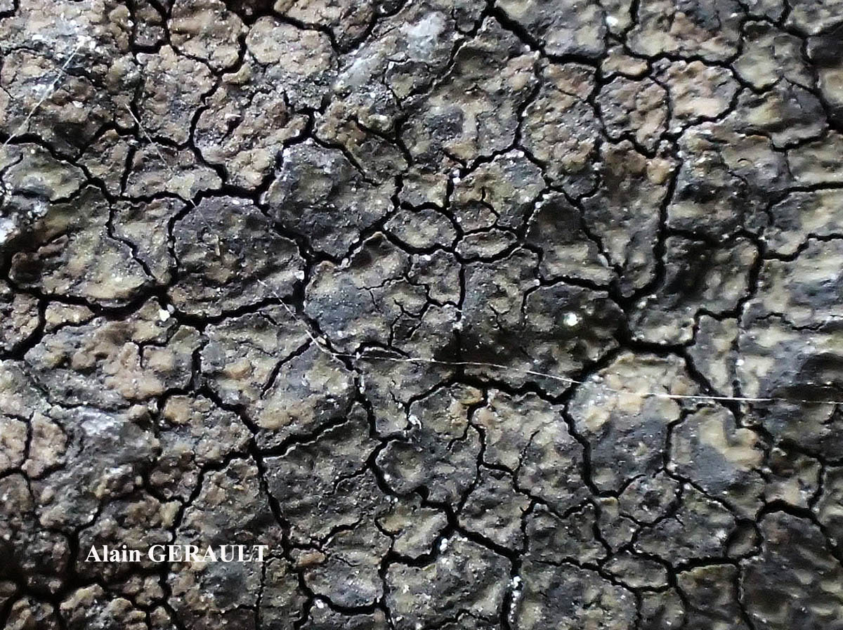
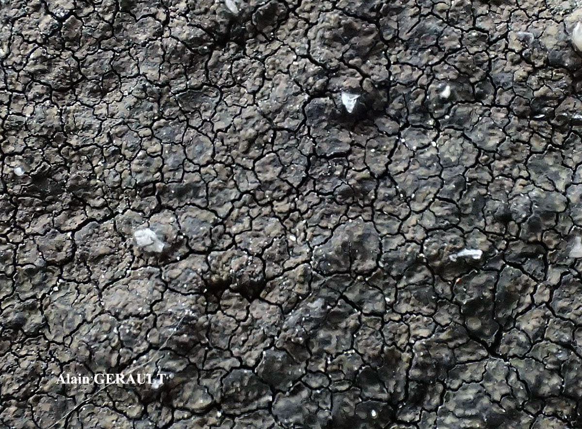
Alain Gerault - Source: http://www.lichensmaritimes.org/index.php?task=fiche&lichen=1090&lang=en
France, Le Passage, Plougastel
Alain Gerault - Source: http://www.lichensmaritimes.org/index.php?task=fiche&lichen=1090&lang=en
France, Le Passage, Plougastel

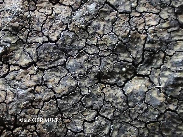
Alain Gerault - Source: http://www.lichensmaritimes.org/index.php?task=fiche&lichen=1090&lang=en
France, Le Passage, Plougastel
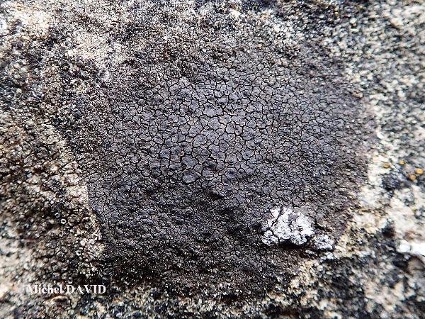
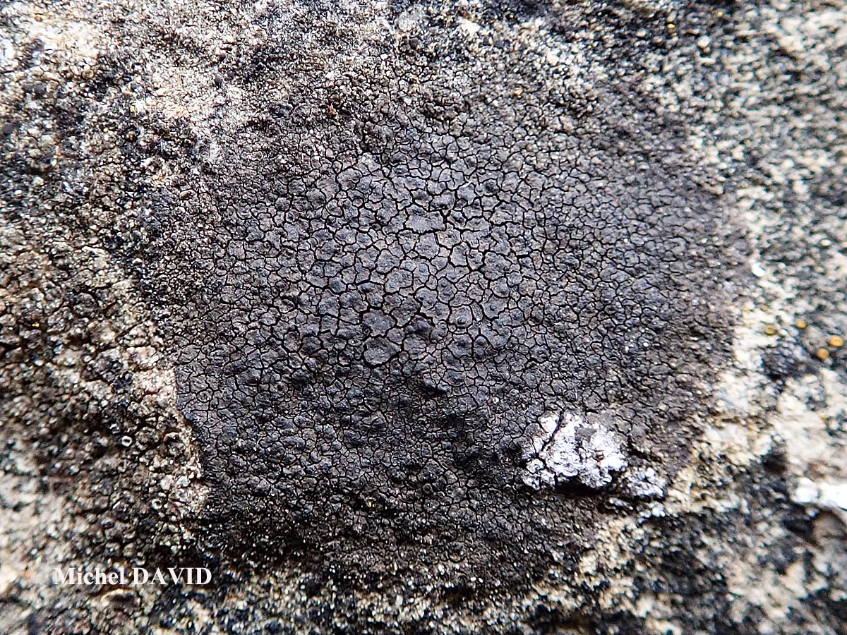
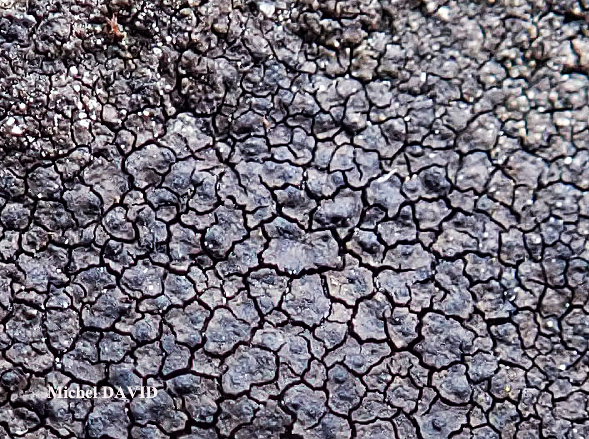
Michel David - Source: http://www.lichensmaritimes.org/index.php?task=fiche&lichen=516&lang=en
France, Aber Four à chaux
Michel David - Source: http://www.lichensmaritimes.org/index.php?task=fiche&lichen=516&lang=en
France, Aber Four à chaux

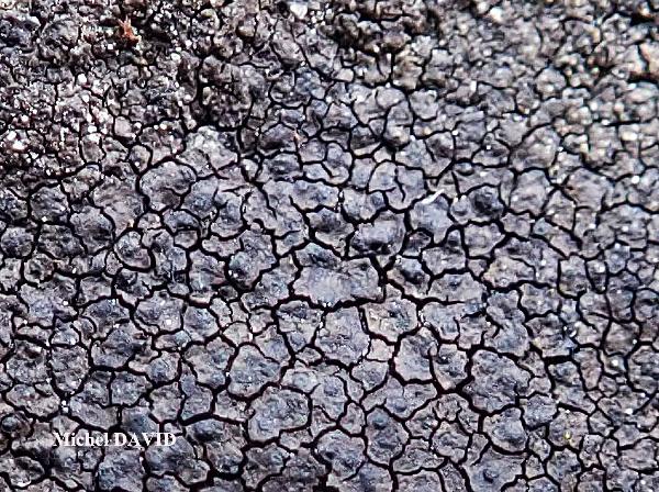
Michel David - Source: http://www.lichensmaritimes.org/index.php?task=fiche&lichen=516&lang=en
France, Aber Four à chaux
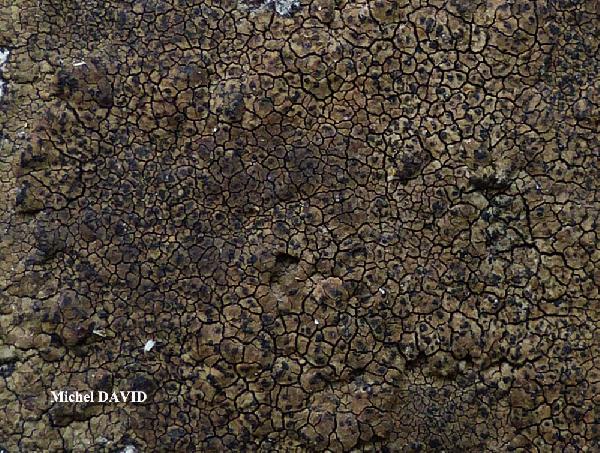
Michel David - Source: http://www.lichensmaritimes.org/index.php?task=fiche&lichen=516&lang=en
France, Corse, Ile du Levant
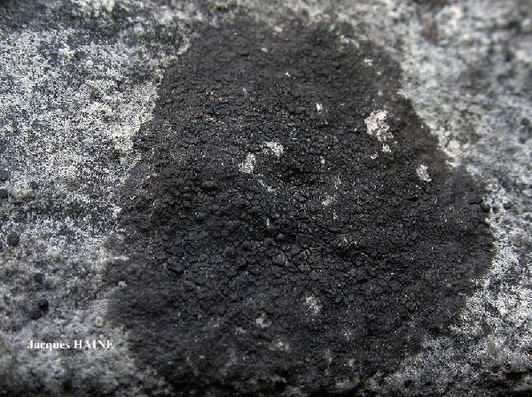
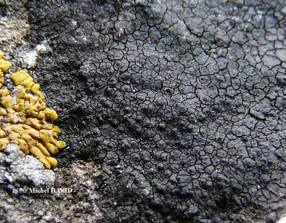
Jacques Haine - Source: http://www.lichensmaritimes.org/index.php?task=fiche&lichen=516&lang=en
France, Ardennes
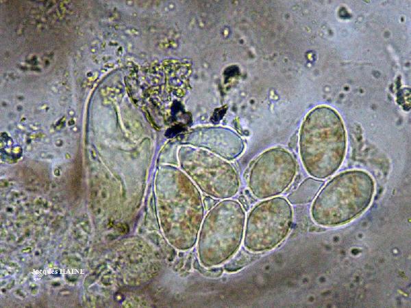
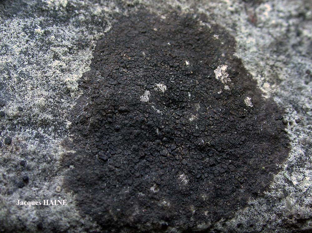
Jacques Haine - Source: http://www.lichensmaritimes.org/index.php?task=fiche&lichen=516&lang=en
France, Ardennes
Felix Schumm - CC BY-SA 4.0
[ABL77539], Brazil, Mato Grosso do Sul, Bonito, Parque National da
Serra da Bodoquena, Rio Perdido, in Atlantic rain forest on limestone.
21°07’' S, 56°43’ W, 510 m. Leg. A. Aptroot (no 77539), 3.11.2018, det.
A. Aptroot, 2019.
Wolfgang von Brackel - CC BY-4.0
Germany, Bavaraia, Hochmutting
Collezione lichenologica Abramo Massalongo del Museo di Storia Naturale G. Ligabue di Venezia - Autori: Seggi, Linda; Trabucco, Raffaella Proprietà: Fondazione Musei Civici di Venezia - CC BY-NC
Italy, Veneto, in op. Tregnago (Campiano) 1855
As Lithoicea acrotelloides
Collezione lichenologica Abramo Massalongo del Museo di Storia Naturale G. Ligabue di Venezia - Autori: Seggi, Linda; Trabucco, Raffaella Proprietà: Fondazione Musei Civici di Venezia - CC BY-NC
Italy, Veneto, in op. Campiano
As Lithoicea acrotelloides
Collezione lichenologica Abramo Massalongo del Museo di Storia Naturale G. Ligabue di Venezia - Autori: Seggi, Linda; Trabucco, Raffaella Proprietà: Fondazione Musei Civici di Venezia - CC BY-NC
Italy, Veneto, L. in op. Tregnago
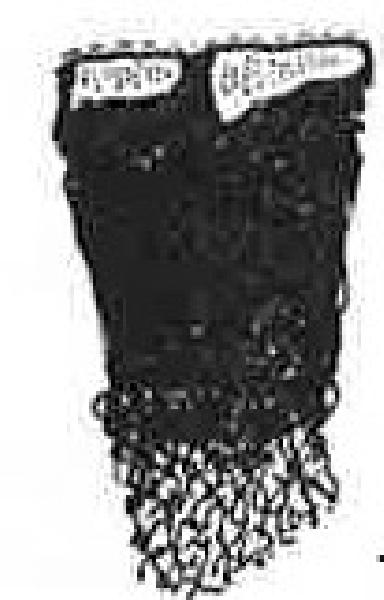
Zschacke, H. (1934) Epigloeaceae, Verrucariaceae und Dermatocarpaceae. In: Dr. L. Rabenhorst‘s Kryptogamen-Flora, Band 9, Abt. 1, Teil 1. Akademische Verlagsgesellschaft, Leipzig, 695 pp. - Public Domain
G. Gibelli, in S. Garovaglio, 1865 Tentamen Dispositionis Methodicae Lichenum In Longobardia Nascentium. Mediolanum
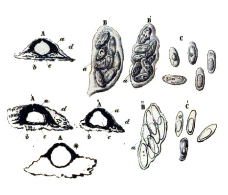
Source: Servit, M 1949: Nove nebo mene zname druhy lisejnikove celedi Verrucariaceae. Species Verrucariacearum (Lichenes) novae vel minus cognitae. - Sbornik Narodniho Musea v Praze 5(9): 1-51. Tab.2 - Public Domain
Source: Servít M. 1954a. Lichenes familiae Verrucariacearum. Prag, 249 pp.
as Verrucaria controversa
Growth form: Crustose
Substrata: rocks
Photobiont: green algae other than Trentepohlia
Reproductive strategy: mainly sexual
Pioneer species
Commonnes-rarity: (info)
Alpine belt: rather common
Subalpine belt: common
Montane belt: extremely common
Dry submediterranean belt: extremely common
Humid submediterranean belt: extremely common
Padanian area: common
pH of the substrata:
| 1 | 2 | 3 | 4 | 5 |
Solar irradiation:
| 1 | 2 | 3 | 4 | 5 |
Aridity:
| 1 | 2 | 3 | 4 | 5 |
Eutrophication:
| 1 | 2 | 3 | 4 | 5 |
Poleotolerance:
| 0 | 1 | 2 | 3 |
Altitudinal distribution:
| 1 | 2 | 3 | 4 | 5 | 6 |
Rarity
absent
extremely rare
very rare
rare
rather rare
rather common
common
very common
extremely common
Loading data...
Occurrence data
Predictive map
Felix Schumm CC BY-SA 4.0
[19673], Germany, Baden-Württemberg, Stuttgart-Hohenheim, beim Botanischen Institut, 48.71081° N, 9.20847° E, 394 m, auf kalkhaltigen (HCL+) Quarzkieselsteinen, TK 7221/3.
Leg. et det. F. Schumm, 12.08.2017

P.L. Nimis; Owner: Department of Life Sciences, University of Trieste
Herbarium: TSB (35728)
2003/01/22
A. Moro; Owner: Department of Life Sciences, University of Trieste
Sicilia, TP, Erice, dintorni della città
2008.04.05
A. Moro; Owner: Department of Life Sciences, University of Trieste
Sicilia, TP, Erice, dintorni della città
2008.04.05
A. Moro; Owner: Department of Life Sciences, University of Trieste
Sicilia, TP, Erice, dintorni della città
2008.04.05
Simonetta Peruzzi; Owner: Simonetta Peruzzi
Italy, Toscana, Celle
2010
Simonetta Peruzzi; Owner: Simonetta Peruzzi
Italy, Toscana, Celle
2010
P.L. Nimis; Owner: Department of Life Sciences, University of Trieste
Italy, Friuli Venezia Giulia, Trieste, Trieste Karst, Rocca di Monrupino (Rupingrande)
07.07.2016
P.L. Nimis; Owner: Department of Life Sciences, University of Trieste
Italy, Friuli Venezia Giulia, Trieste, Trieste Karst, Rocca di Monrupino (Rupingrande)
07.07.2016

Andrea Moro; Owner: Department of Life Sciences, University of Trieste
italy, Friuli Venezia Giulia, Trieste, Trieste Karst near Borgo Grotta Gigante
16/02/2017
Andrea Moro; Owner: Department of Life Sciences, University of Trieste
italy, Friuli Venezia Giulia, Trieste, Trieste Karst near Borgo Grotta Gigante
16/02/2017
Andrea Moro; Owner: Department of Life Sciences, University of Trieste
italy, Friuli Venezia Giulia, Trieste, Trieste Karst near Borgo Grotta Gigante
16/02/2017

Andrea Moro; Owner: Department of Life Sciences, University of Trieste
italy, Friuli Venezia Giulia, Trieste, Trieste Karst near Borgo Grotta Gigante
16/02/2017
Andrea Moro; Owner: Department of Life Sciences, University of Triedte
Italy, Friuli Venezia Giulia, Trieste, Trieste Karst, Rocca di Monrupino
20/02/2017
Andrea Moro; Owner: Department of Life Sciences, University of Triedte
Italy, Friuli Venezia Giulia, Trieste, Trieste Karst, Rocca di Monrupino
20/02/2017

Felix Schumm - CC BY-SA 4.0
[16603], Germany, Baden-Württemberg, Schwäbische Alb, Kreis Reutlingen, zwischen Seeburg und Münsingen nahe der Abzweigung nach Rietheim, 48.43164° N, 9.46574° E, 730 m, an Kalkblöcken. Leg. et det. Schumm 14.08.2010, test. A. Aptroot 2011.
Albino Form!
Felix Schumm - CC BY-SA 4.0
[16603], Germany, Baden-Württemberg, Schwäbische Alb, Kreis Reutlingen, zwischen Seeburg und Münsingen nahe der Abzweigung nach Rietheim, 48.43164° N, 9.46574° E, 730 m, an Kalkblöcken. Leg. et det. Schumm 14.08.2010, test. A. Aptroot 2011.

Felix Schumm - CC BY-SA 4.0
[16603], Germany, Baden-Württemberg, Schwäbische Alb, Kreis Reutlingen, zwischen Seeburg und Münsingen nahe der Abzweigung nach Rietheim, 48.43164° N, 9.46574° E, 730 m, an Kalkblöcken. Leg. et det. Schumm 14.08.2010, test. A. Aptroot 2011.
Felix Schumm - CC BY-SA 4.0
[16603], Germany, Baden-Württemberg, Schwäbische Alb, Kreis Reutlingen, zwischen Seeburg und Münsingen nahe der Abzweigung nach Rietheim, 48.43164° N, 9.46574° E, 730 m, an Kalkblöcken. Leg. et det. Schumm 14.08.2010, test. A. Aptroot 2011.
Felix Schumm - CC BY-SA 4.0
[16603], Germany, Baden-Württemberg, Schwäbische Alb, Kreis Reutlingen, zwischen Seeburg und Münsingen nahe der Abzweigung nach Rietheim, 48.43164° N, 9.46574° E, 730 m, an Kalkblöcken. Leg. et det. Schumm 14.08.2010, test. A. Aptroot 2011.

Felix Schumm - CC BY-SA 4.0
[16603], Germany, Baden-Württemberg, Schwäbische Alb, Kreis Reutlingen, zwischen Seeburg und Münsingen nahe der Abzweigung nach Rietheim, 48.43164° N, 9.46574° E, 730 m, an Kalkblöcken. Leg. et det. Schumm 14.08.2010, test. A. Aptroot 2011.
Felix Schumm - CC BY-SA 4.0
[16603], Germany, Baden-Württemberg, Schwäbische Alb, Kreis Reutlingen, zwischen Seeburg und Münsingen nahe der Abzweigung nach Rietheim, 48.43164° N, 9.46574° E, 730 m, an Kalkblöcken. Leg. et det. Schumm 14.08.2010, test. A. Aptroot 2011.

Felix Schumm - CC BY-SA 4.0
[16603], Germany, Baden-Württemberg, Schwäbische Alb, Kreis Reutlingen, zwischen Seeburg und Münsingen nahe der Abzweigung nach Rietheim, 48.43164° N, 9.46574° E, 730 m, an Kalkblöcken. Leg. et det. Schumm 14.08.2010, test. A. Aptroot 2011.
Felix Schumm - CC BY-SA 4.0
[16603], Germany, Baden-Württemberg, Schwäbische Alb, Kreis Reutlingen, zwischen Seeburg und Münsingen nahe der Abzweigung nach Rietheim, 48.43164° N, 9.46574° E, 730 m, an Kalkblöcken. Leg. et det. Schumm 14.08.2010, test. A. Aptroot 2011.

Felix Schumm - CC BY-SA 4.0
[16603], Germany, Baden-Württemberg, Schwäbische Alb, Kreis Reutlingen, zwischen Seeburg und Münsingen nahe der Abzweigung nach Rietheim, 48.43164° N, 9.46574° E, 730 m, an Kalkblöcken. Leg. et det. Schumm 14.08.2010, test. A. Aptroot 2011.
Felix Schumm - CC BY-SA 4.0
[16603], Germany, Baden-Württemberg, Schwäbische Alb, Kreis Reutlingen, zwischen Seeburg und Münsingen nahe der Abzweigung nach Rietheim, 48.43164° N, 9.46574° E, 730 m, an Kalkblöcken. Leg. et det. Schumm 14.08.2010, test. A. Aptroot 2011.

Felix Schumm - CC BY-SA 4.0
[16603], Germany, Baden-Württemberg, Schwäbische Alb, Kreis Reutlingen, zwischen Seeburg und Münsingen nahe der Abzweigung nach Rietheim, 48.43164° N, 9.46574° E, 730 m, an Kalkblöcken. Leg. et det. Schumm 14.08.2010, test. A. Aptroot 2011.
Felix Schumm - CC BY-SA 4.0
[16603], Germany, Baden-Württemberg, Schwäbische Alb, Kreis Reutlingen, zwischen Seeburg und Münsingen nahe der Abzweigung nach Rietheim, 48.43164° N, 9.46574° E, 730 m, an Kalkblöcken. Leg. et det. Schumm 14.08.2010, test. A. Aptroot 2011.
Felix Schumm - CC BY-SA 4.0
[16603], Germany, Baden-Württemberg, Schwäbische Alb, Kreis Reutlingen, zwischen Seeburg und Münsingen nahe der Abzweigung nach Rietheim, 48.43164° N, 9.46574° E, 730 m, an Kalkblöcken. Leg. et det. Schumm 14.08.2010, test. A. Aptroot 2011.
Felix Schumm - CC BY-SA 4.0
[16708], Germany, Baden-Württemberg, Kreis Göppingen, zwischen Wangen und Unterberken, ehemaliges Militärdepot, auf verwitternden, kleinen Betonmauern, 48.75052° N, 9.57469° E, 480 m. Leg. et det. Schumm 10.10.2010, test. A.Aptroot 2011.
Felix Schumm - CC BY-SA 4.0
[16708], Germany, Baden-Württemberg, Kreis Göppingen, zwischen Wangen und Unterberken, ehemaliges Militärdepot, auf verwitternden, kleinen Betonmauern, 48.75052° N, 9.57469° E, 480 m. Leg. et det. Schumm 10.10.2010, test. A.Aptroot 2011.
Felix Schumm - CC BY-SA 4.0
[16708], Germany, Baden-Württemberg, Kreis Göppingen, zwischen Wangen und Unterberken, ehemaliges Militärdepot, auf verwitternden, kleinen Betonmauern, 48.75052° N, 9.57469° E, 480 m. Leg. et det. Schumm 10.10.2010, test. A.Aptroot 2011.
Felix Schumm - CC BY-SA 4.0
[16708], Germany, Baden-Württemberg, Kreis Göppingen, zwischen Wangen und Unterberken, ehemaliges Militärdepot, auf verwitternden, kleinen Betonmauern, 48.75052° N, 9.57469° E, 480 m. Leg. et det. Schumm 10.10.2010, test. A.Aptroot 2011.

Felix Schumm - CC BY-SA 4.0
[16708], Germany, Baden-Württemberg, Kreis Göppingen, zwischen Wangen und Unterberken, ehemaliges Militärdepot, auf verwitternden, kleinen Betonmauern, 48.75052° N, 9.57469° E, 480 m. Leg. et det. Schumm 10.10.2010, test. A.Aptroot 2011.
Felix Schumm - CC BY-SA 4.0
[16708], Germany, Baden-Württemberg, Kreis Göppingen, zwischen Wangen und Unterberken, ehemaliges Militärdepot, auf verwitternden, kleinen Betonmauern, 48.75052° N, 9.57469° E, 480 m. Leg. et det. Schumm 10.10.2010, test. A.Aptroot 2011.
Felix Schumm - CC BY-SA 4.0
[16708], Germany, Baden-Württemberg, Kreis Göppingen, zwischen Wangen und Unterberken, ehemaliges Militärdepot, auf verwitternden, kleinen Betonmauern, 48.75052° N, 9.57469° E, 480 m. Leg. et det. Schumm 10.10.2010, test. A.Aptroot 2011.
Felix Schumm - CC BY-SA 4.0
[16708], Germany, Baden-Württemberg, Kreis Göppingen, zwischen Wangen und Unterberken, ehemaliges Militärdepot, auf verwitternden, kleinen Betonmauern, 48.75052° N, 9.57469° E, 480 m. Leg. et det. Schumm 10.10.2010, test. A.Aptroot 2011.
Felix Schumm - CC BY-SA 4.0
[16708], Germany, Baden-Württemberg, Kreis Göppingen, zwischen Wangen und Unterberken, ehemaliges Militärdepot, auf verwitternden, kleinen Betonmauern, 48.75052° N, 9.57469° E, 480 m. Leg. et det. Schumm 10.10.2010, test. A.Aptroot 2011.

Felix Schumm - CC BY-SA 4.0
[16708], Germany, Baden-Württemberg, Kreis Göppingen, zwischen Wangen und Unterberken, ehemaliges Militärdepot, auf verwitternden, kleinen Betonmauern, 48.75052° N, 9.57469° E, 480 m. Leg. et det. Schumm 10.10.2010, test. A.Aptroot 2011.
Felix Schumm – CC BY-SA 4.0
[19673], Germany, Baden-Württemberg, Stuttgart-Hohenheim, beim Botanischen Institut, 48.71081° N, 9.20847° E, 394 m, auf kalkhaltigen (HCL+) Quarzkieselsteinen, TK 7221/3. Leg. et det. F. Schumm, 12.08.2017
P.L. Nimis; Owner: Department of Life Sciences, University of Trieste
Herbarium: TSB (11817)
2001/12/03
Felix Schumm – CC BY-SA 4.0
[19673], Germany, Baden-Württemberg, Stuttgart-Hohenheim, beim Botanischen Institut, 48.71081° N, 9.20847° E, 394 m, auf kalkhaltigen (HCL+) Quarzkieselsteinen, TK 7221/3. Leg. et det. F. Schumm, 12.08.2017
Felix Schumm – CC BY-SA 4.0
[19673], Germany, Baden-Württemberg, Stuttgart-Hohenheim, beim Botanischen Institut, 48.71081° N, 9.20847° E, 394 m, auf kalkhaltigen (HCL+) Quarzkieselsteinen, TK 7221/3. Leg. et det. F. Schumm, 12.08.2017
Felix Schumm – CC BY-SA 4.0
[19673], Germany, Baden-Württemberg, Stuttgart-Hohenheim, beim Botanischen Institut, 48.71081° N, 9.20847° E, 394 m, auf kalkhaltigen (HCL+) Quarzkieselsteinen, TK 7221/3. Leg. et det. F. Schumm, 12.08.2017
Felix Schumm – CC BY-SA 4.0
[19673], Germany, Baden-Württemberg, Stuttgart-Hohenheim, beim Botanischen Institut, 48.71081° N, 9.20847° E, 394 m, auf kalkhaltigen (HCL+) Quarzkieselsteinen, TK 7221/3. Leg. et det. F. Schumm, 12.08.2017

Felix Schumm – CC BY-SA 4.0
[19673], Germany, Baden-Württemberg, Stuttgart-Hohenheim, beim Botanischen Institut, 48.71081° N, 9.20847° E, 394 m, auf kalkhaltigen (HCL+) Quarzkieselsteinen, TK 7221/3. Leg. et det. F. Schumm, 12.08.2017
Felix Schumm – CC BY-SA 4.0
[19673], Germany, Baden-Württemberg, Stuttgart-Hohenheim, beim Botanischen Institut, 48.71081° N, 9.20847° E, 394 m, auf kalkhaltigen (HCL+) Quarzkieselsteinen, TK 7221/3. Leg. et det. F. Schumm, 12.08.2017
Felix Schumm – CC BY-SA 4.0
[19673], Germany, Baden-Württemberg, Stuttgart-Hohenheim, beim Botanischen Institut, 48.71081° N, 9.20847° E, 394 m, auf kalkhaltigen (HCL+) Quarzkieselsteinen, TK 7221/3. Leg. et det. F. Schumm, 12.08.2017
Felix Schumm – CC BY-SA 4.0
[19673], Germany, Baden-Württemberg, Stuttgart-Hohenheim, beim Botanischen Institut, 48.71081° N, 9.20847° E, 394 m, auf kalkhaltigen (HCL+) Quarzkieselsteinen, TK 7221/3. Leg. et det. F. Schumm, 12.08.2017
Felix Schumm – CC BY-SA 4.0
[19673], Germany, Baden-Württemberg, Stuttgart-Hohenheim, beim Botanischen Institut, 48.71081° N, 9.20847° E, 394 m, auf kalkhaltigen (HCL+) Quarzkieselsteinen, TK 7221/3. Leg. et det. F. Schumm, 12.08.2017
Felix Schumm – CC BY-SA 4.0
[19673], Germany, Baden-Württemberg, Stuttgart-Hohenheim, beim Botanischen Institut, 48.71081° N, 9.20847° E, 394 m, auf kalkhaltigen (HCL+) Quarzkieselsteinen, TK 7221/3. Leg. et det. F. Schumm, 12.08.2017
Pier Luigi Nimis - CC BY-SA 4.0
TSB 36728
Felix Schumm – CC BY-SA 4.0
[19673], Germany, Baden-Württemberg, Stuttgart-Hohenheim, beim Botanischen Institut, 48.71081° N, 9.20847° E, 394 m, auf kalkhaltigen (HCL+) Quarzkieselsteinen, TK 7221/3. Leg. et det. F. Schumm, 12.08.2017
Courtesy Danièle et Olivier Gonnet - Source: https://www.afl-lichenologie.fr/Photos_AFL/Photos_AFL_V/Verrucaria_nigrescens.htm
France, session AFL 2005 Ardèche
Courtesy Danièle et Olivier Gonnet - Source: https://www.afl-lichenologie.fr/Photos_AFL/Photos_AFL_V/Verrucaria_nigrescens.htm
France, session AFL 2005 Ardèche
Courtesy Danièle et Olivier Gonnet - Source: https://www.afl-lichenologie.fr/Photos_AFL/Photos_AFL_V/Verrucaria_nigrescens.htm
France, session AFL 2005 Ardèche
Alain Gerault - Source: http://www.lichensmaritimes.org/index.php?task=fiche&lichen=1090&lang=en
France, Le Passage, Plougastel
Alain Gerault - Source: http://www.lichensmaritimes.org/index.php?task=fiche&lichen=1090&lang=en
France, Le Passage, Plougastel
Alain Gerault - Source: http://www.lichensmaritimes.org/index.php?task=fiche&lichen=1090&lang=en
France, Le Passage, Plougastel
Michel David - Source: http://www.lichensmaritimes.org/index.php?task=fiche&lichen=516&lang=en
France, Aber Four à chaux
Michel David - Source: http://www.lichensmaritimes.org/index.php?task=fiche&lichen=516&lang=en
France, Aber Four à chaux
Michel David - Source: http://www.lichensmaritimes.org/index.php?task=fiche&lichen=516&lang=en
France, Aber Four à chaux

Michel David - Source: http://www.lichensmaritimes.org/index.php?task=fiche&lichen=516&lang=en
France, Corse, Ile du Levant
Jacques Haine - Source: http://www.lichensmaritimes.org/index.php?task=fiche&lichen=516&lang=en
France, Ardennes
Jacques Haine - Source: http://www.lichensmaritimes.org/index.php?task=fiche&lichen=516&lang=en
France, Ardennes

Felix Schumm - CC BY-SA 4.0
[ABL77539], Brazil, Mato Grosso do Sul, Bonito, Parque National da Serra da Bodoquena, Rio Perdido, in Atlantic rain forest on limestone. 21°07’' S, 56°43’ W, 510 m. Leg. A. Aptroot (no 77539), 3.11.2018, det. A. Aptroot, 2019.

Wolfgang von Brackel - CC BY-4.0
Germany, Bavaraia, Hochmutting

Collezione lichenologica Abramo Massalongo del Museo di Storia Naturale G. Ligabue di Venezia - Autori: Seggi, Linda; Trabucco, Raffaella Proprietà: Fondazione Musei Civici di Venezia - CC BY-NC
Italy, Veneto, in op. Tregnago (Campiano) 1855
As Lithoicea acrotelloides

Collezione lichenologica Abramo Massalongo del Museo di Storia Naturale G. Ligabue di Venezia - Autori: Seggi, Linda; Trabucco, Raffaella Proprietà: Fondazione Musei Civici di Venezia - CC BY-NC
Italy, Veneto, in op. Campiano
As Lithoicea acrotelloides

Collezione lichenologica Abramo Massalongo del Museo di Storia Naturale G. Ligabue di Venezia - Autori: Seggi, Linda; Trabucco, Raffaella Proprietà: Fondazione Musei Civici di Venezia - CC BY-NC
Italy, Veneto, L. in op. Tregnago
Zschacke, H. (1934) Epigloeaceae, Verrucariaceae und Dermatocarpaceae. In: Dr. L. Rabenhorst‘s Kryptogamen-Flora, Band 9, Abt. 1, Teil 1. Akademische Verlagsgesellschaft, Leipzig, 695 pp. - Public Domain
G. Gibelli, in S. Garovaglio, 1865 Tentamen Dispositionis Methodicae Lichenum In Longobardia Nascentium. Mediolanum

Source: Servit, M 1949: Nove nebo mene zname druhy lisejnikove celedi Verrucariaceae. Species Verrucariacearum (Lichenes) novae vel minus cognitae. - Sbornik Narodniho Musea v Praze 5(9): 1-51. Tab.2 - Public Domain


