
Botryolepraria lesdainii (Hue) Canals, Hern.-Mar., Gómez-Bolea & Llimona
Lichenologist, 29: 340, 1997. Basionym: Crocynia lesdainii Hue - Bull. Soc. Bot. France, 71: 350, 1924.
Synonyms: Crocynia grevilleana B. de Lesd.; Lepraria lesdainii (Hue) R.C. Harris
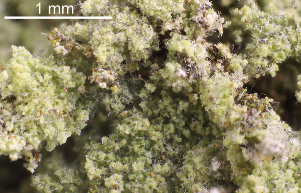
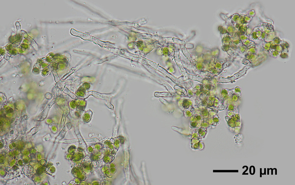
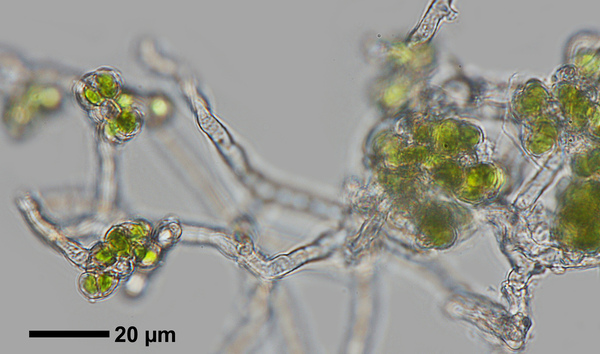
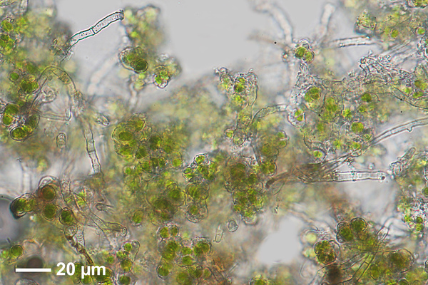
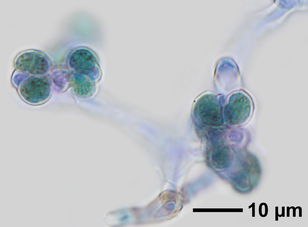
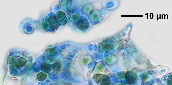
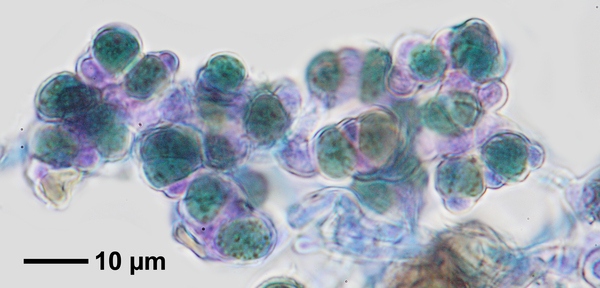
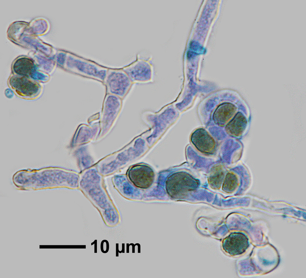
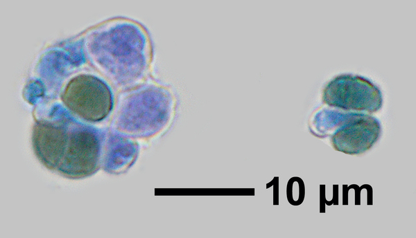
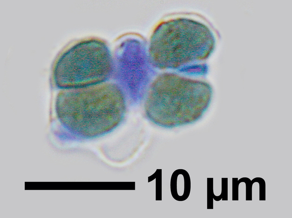
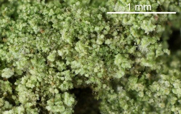
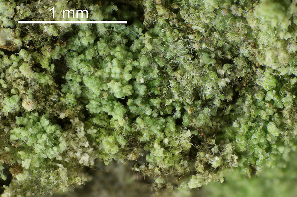
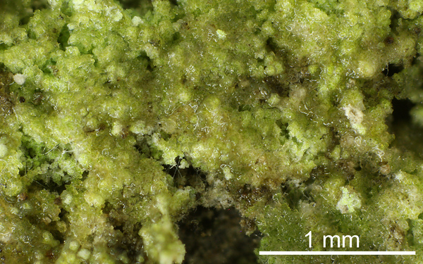
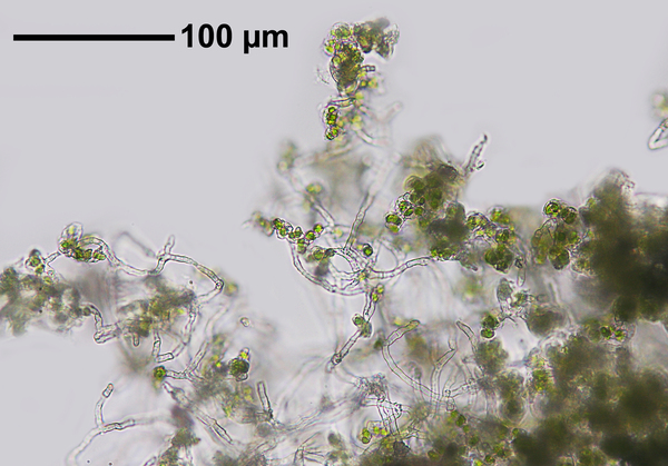
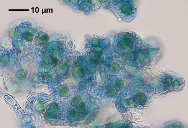
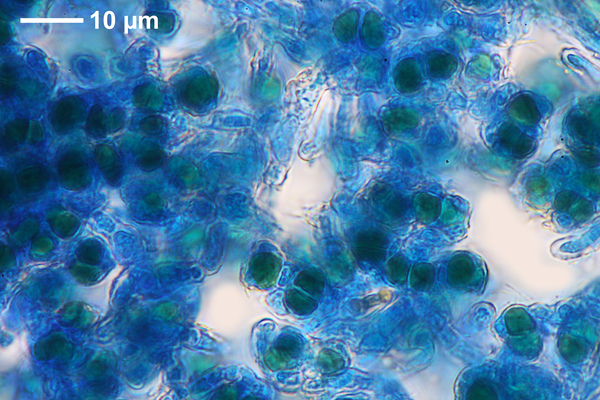
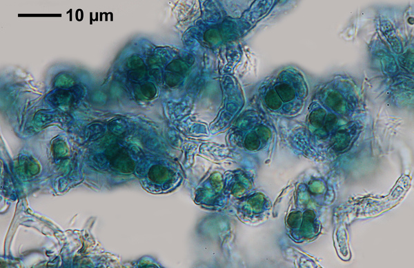
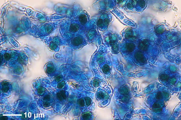
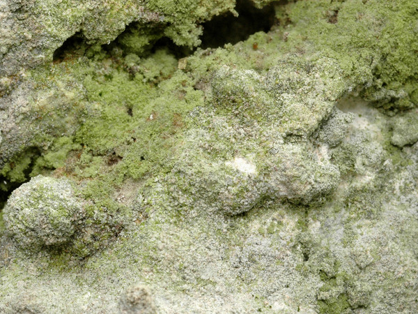
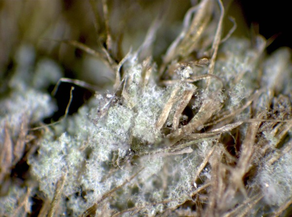
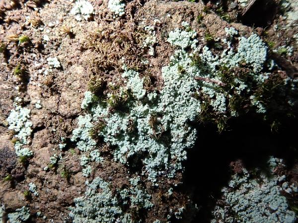
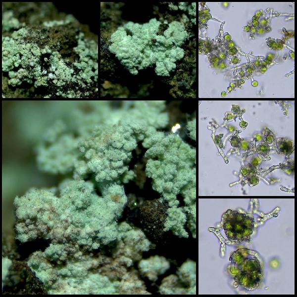
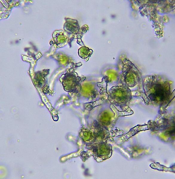
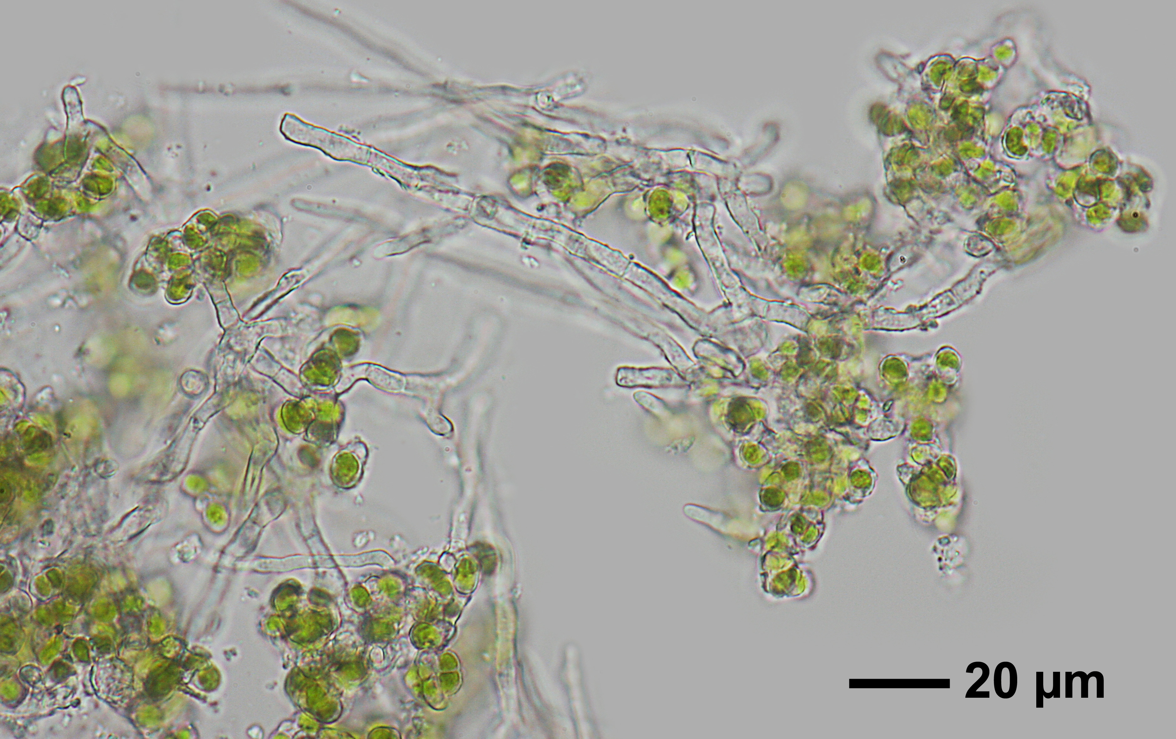
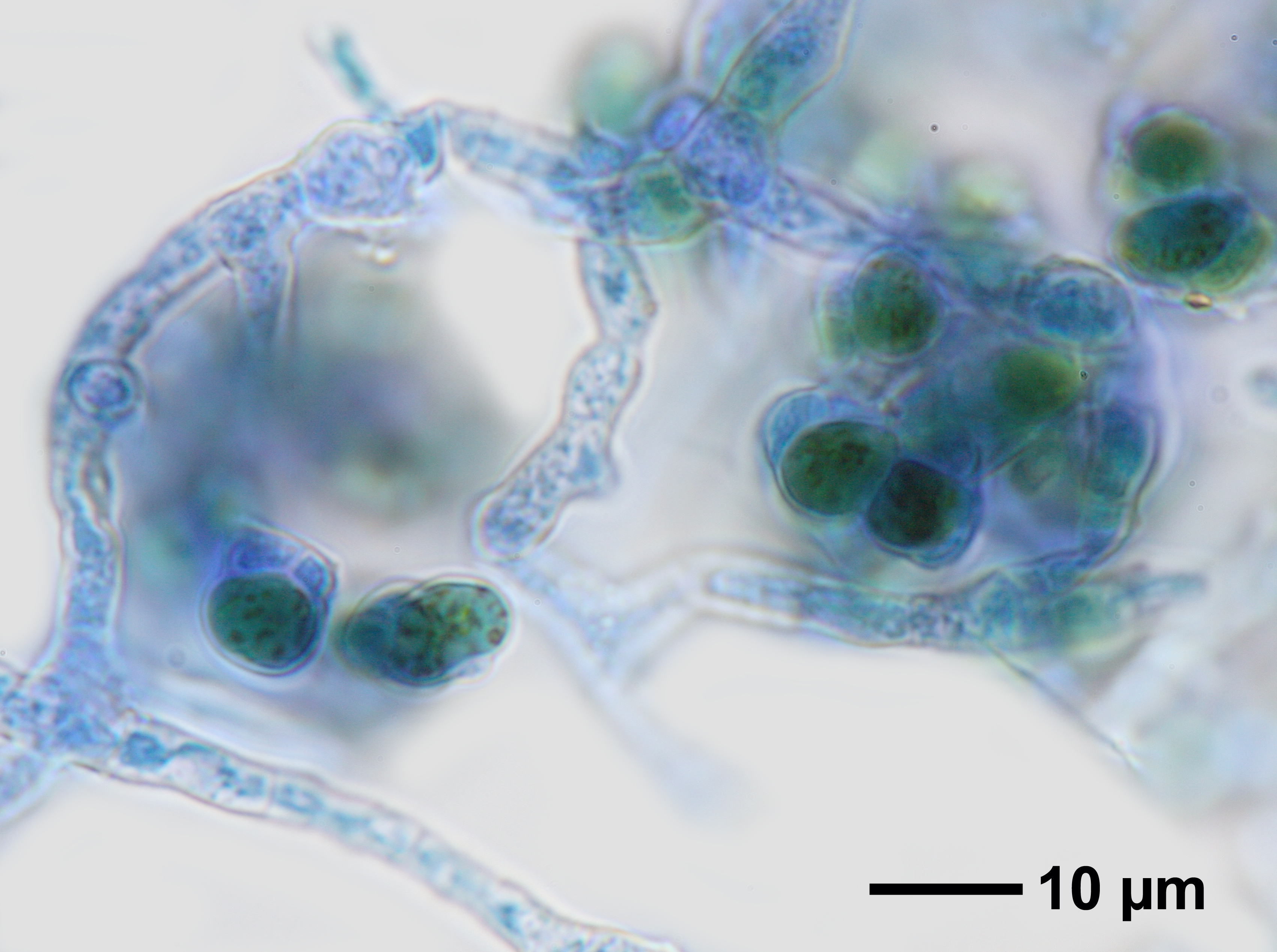
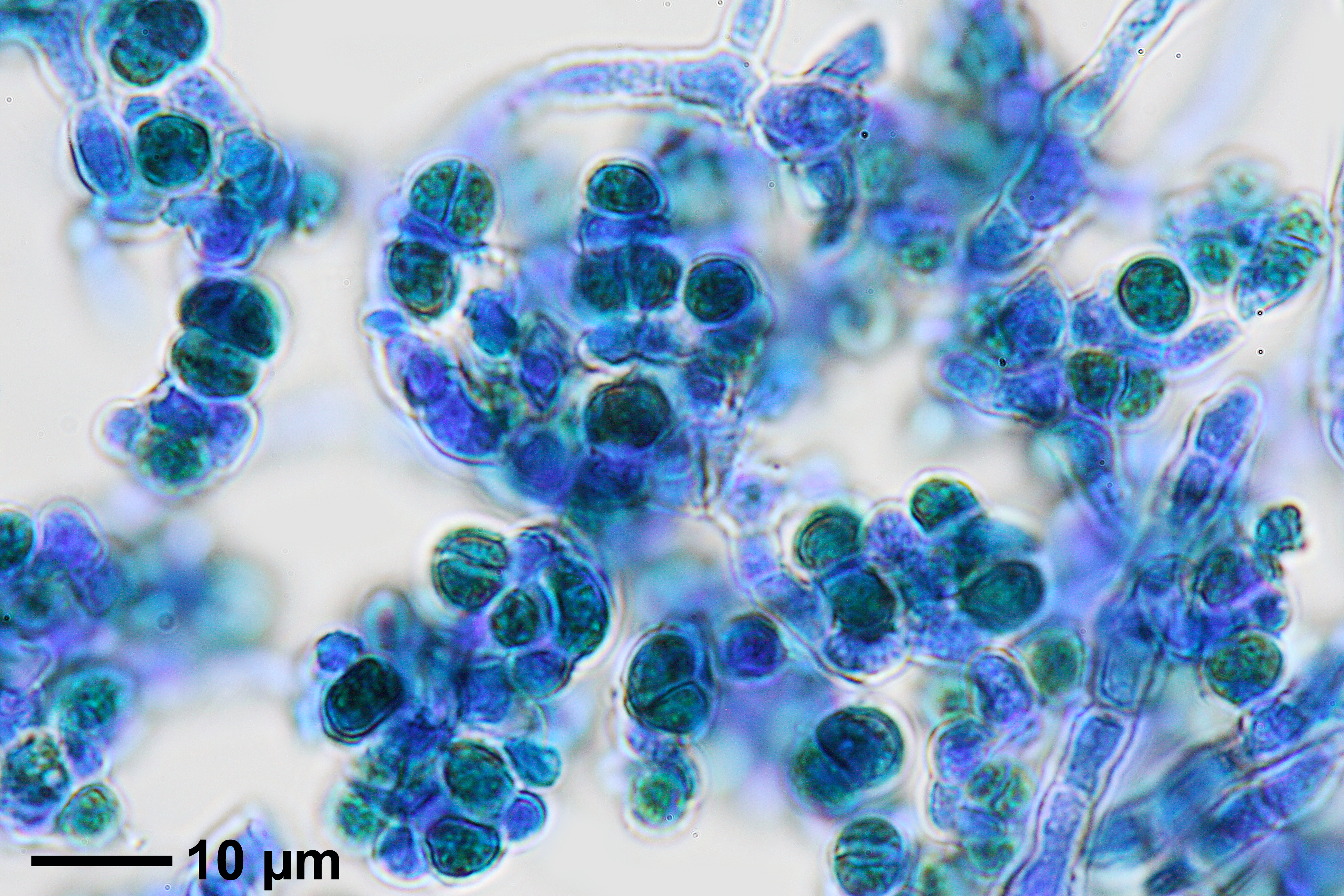
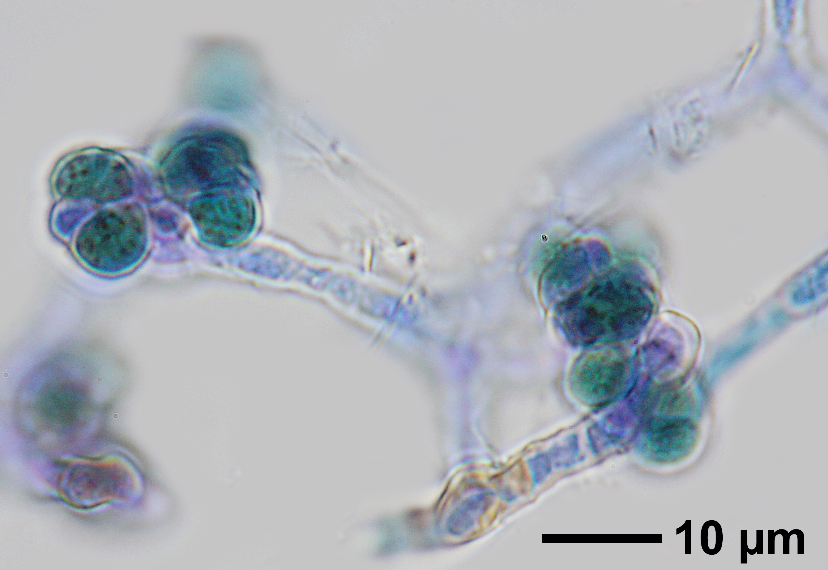
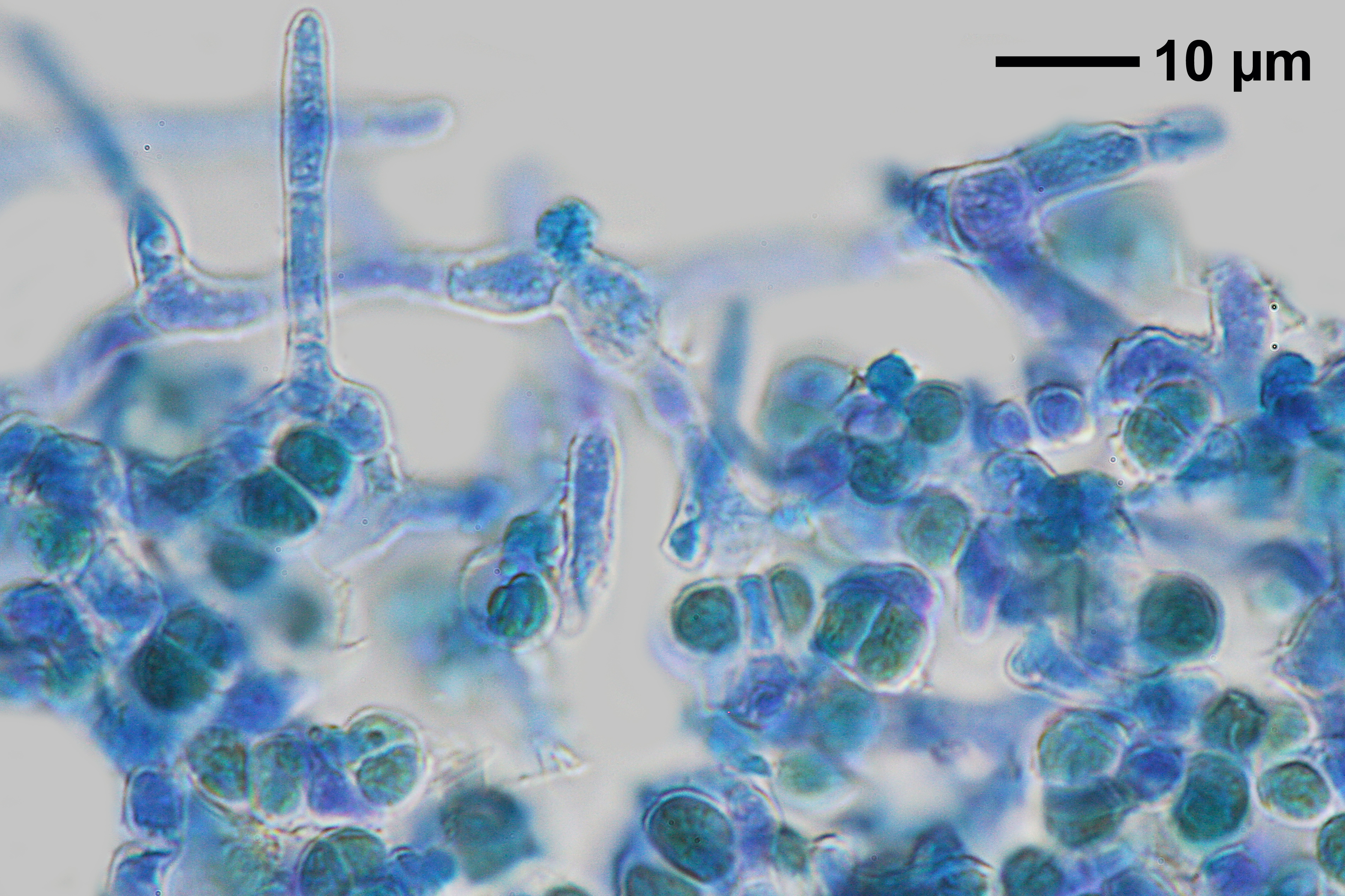
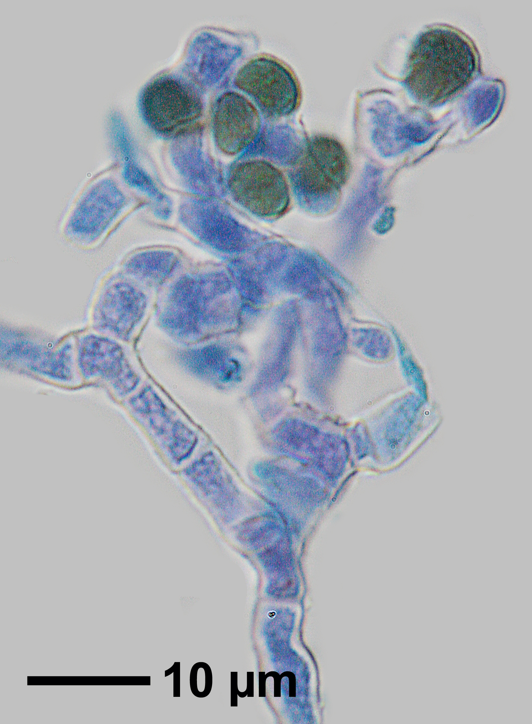
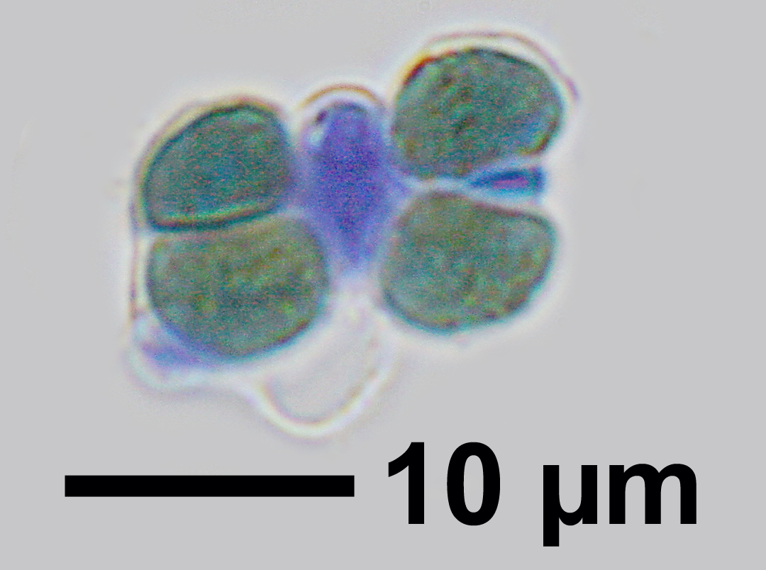
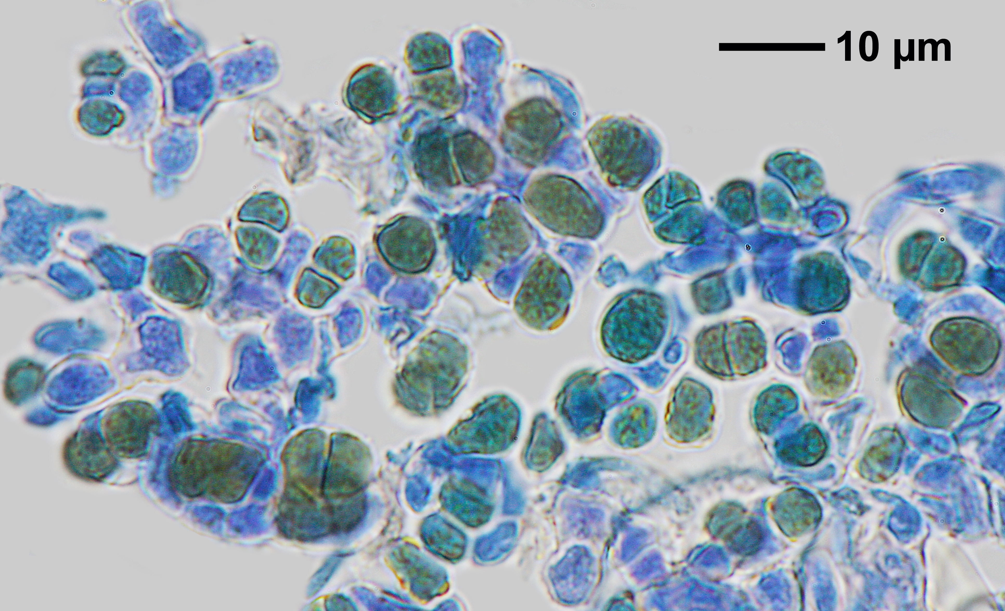
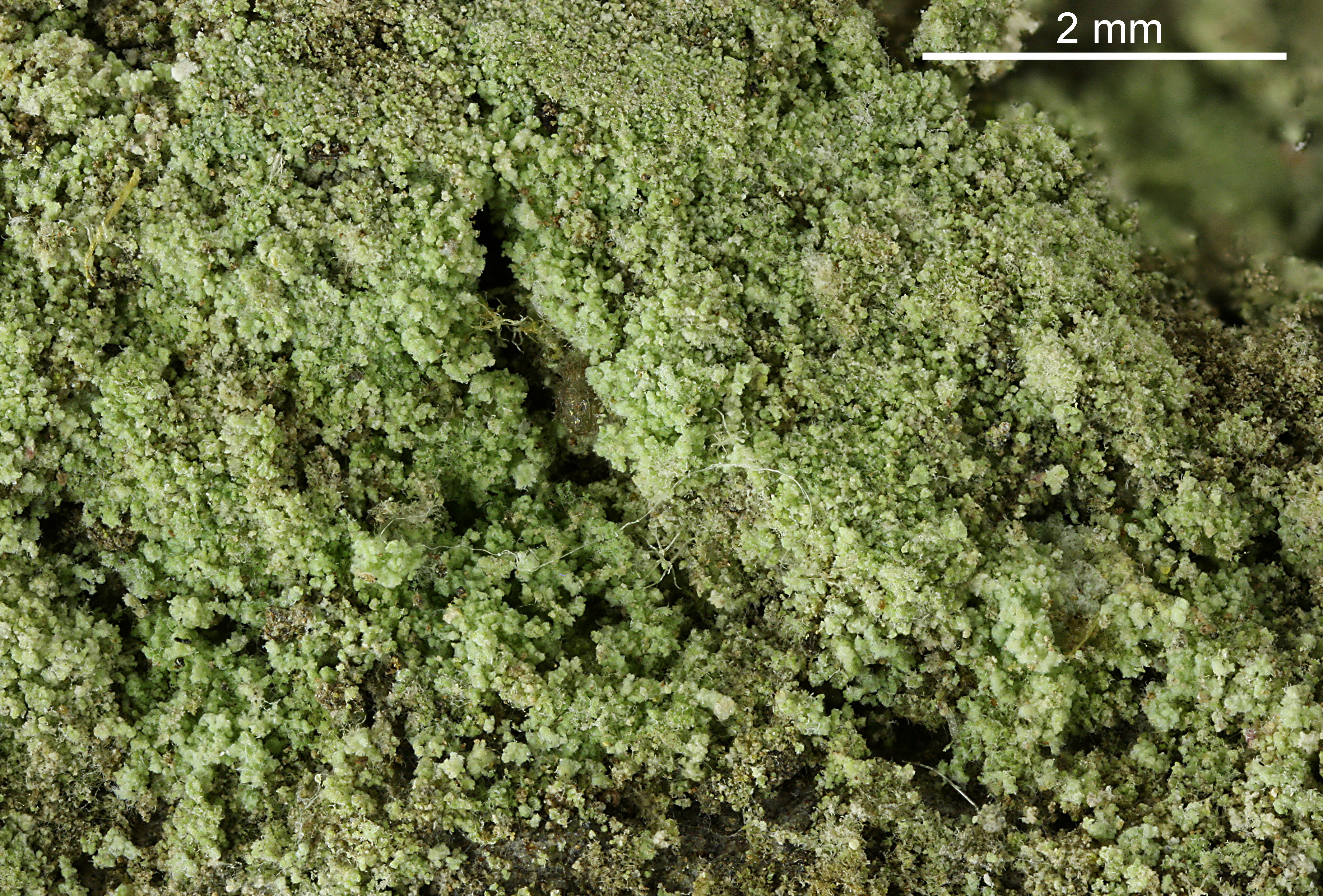
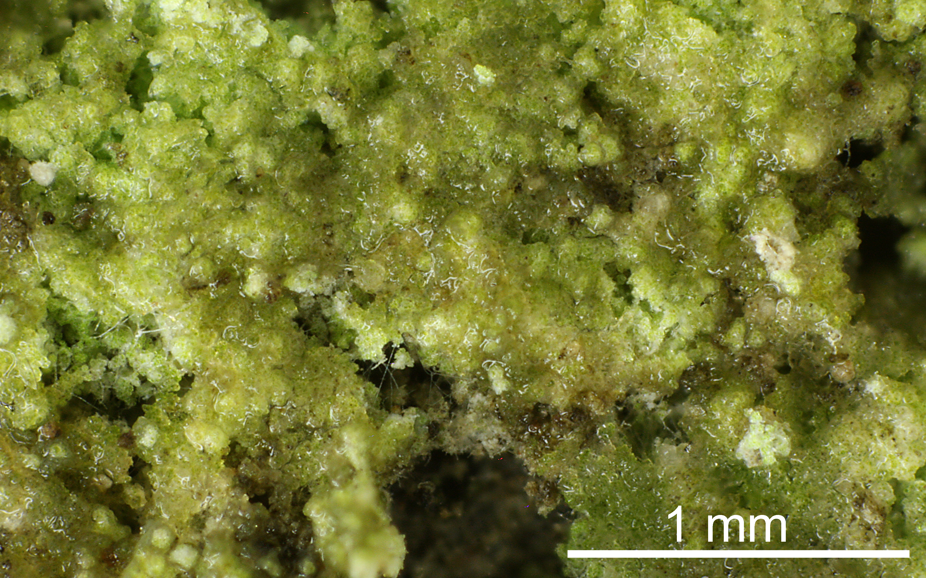
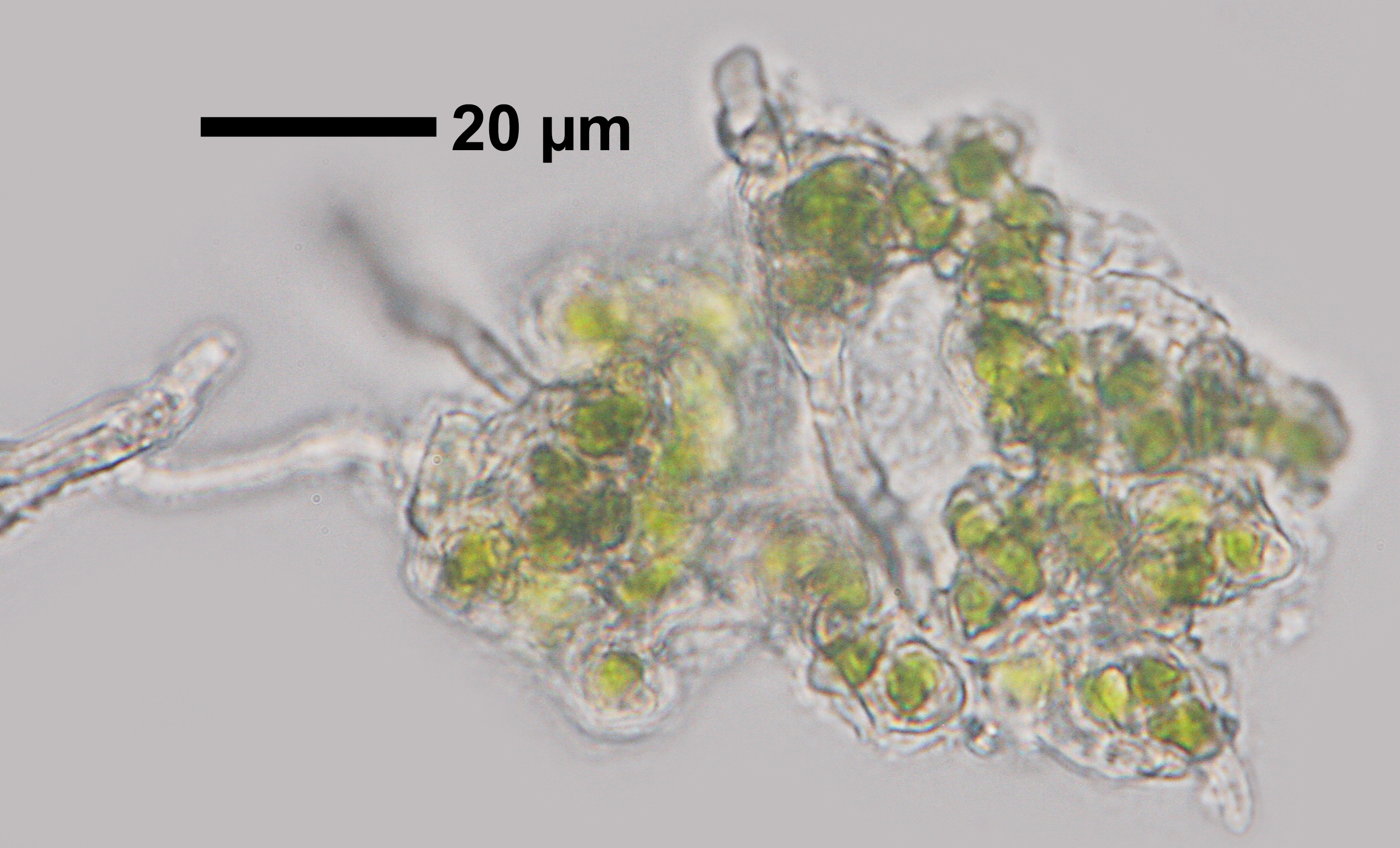
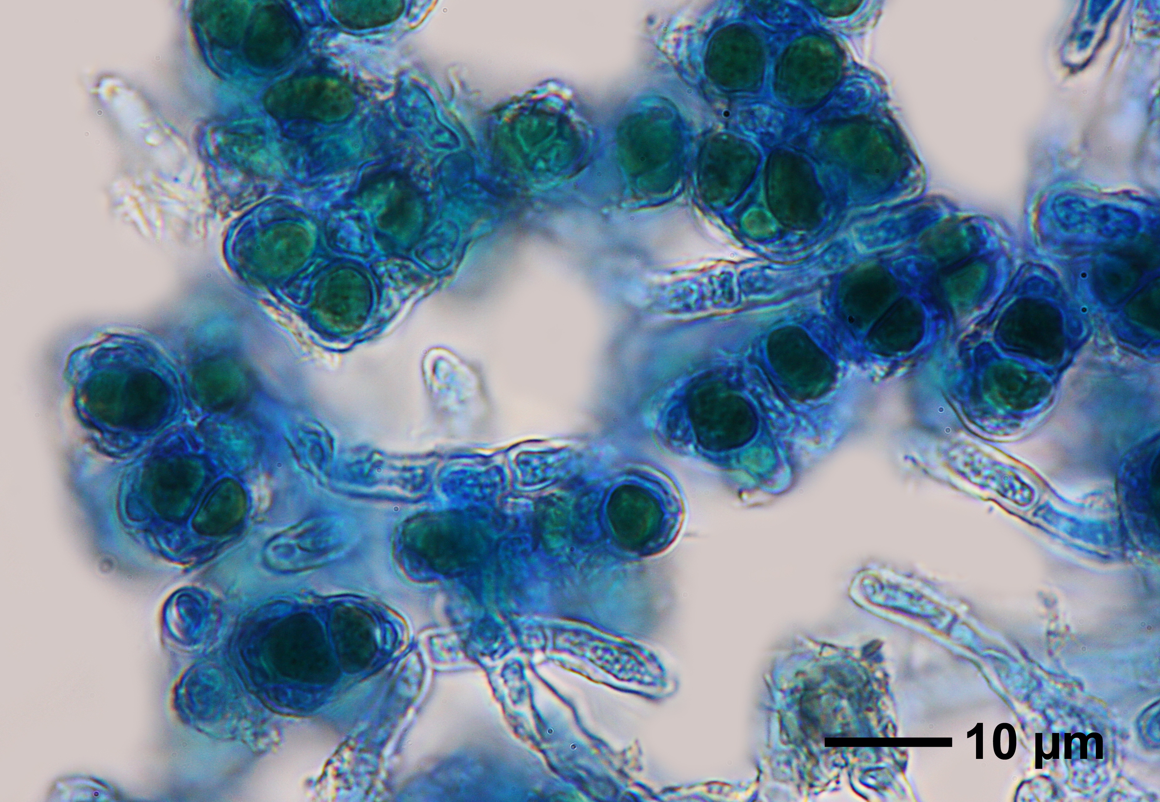
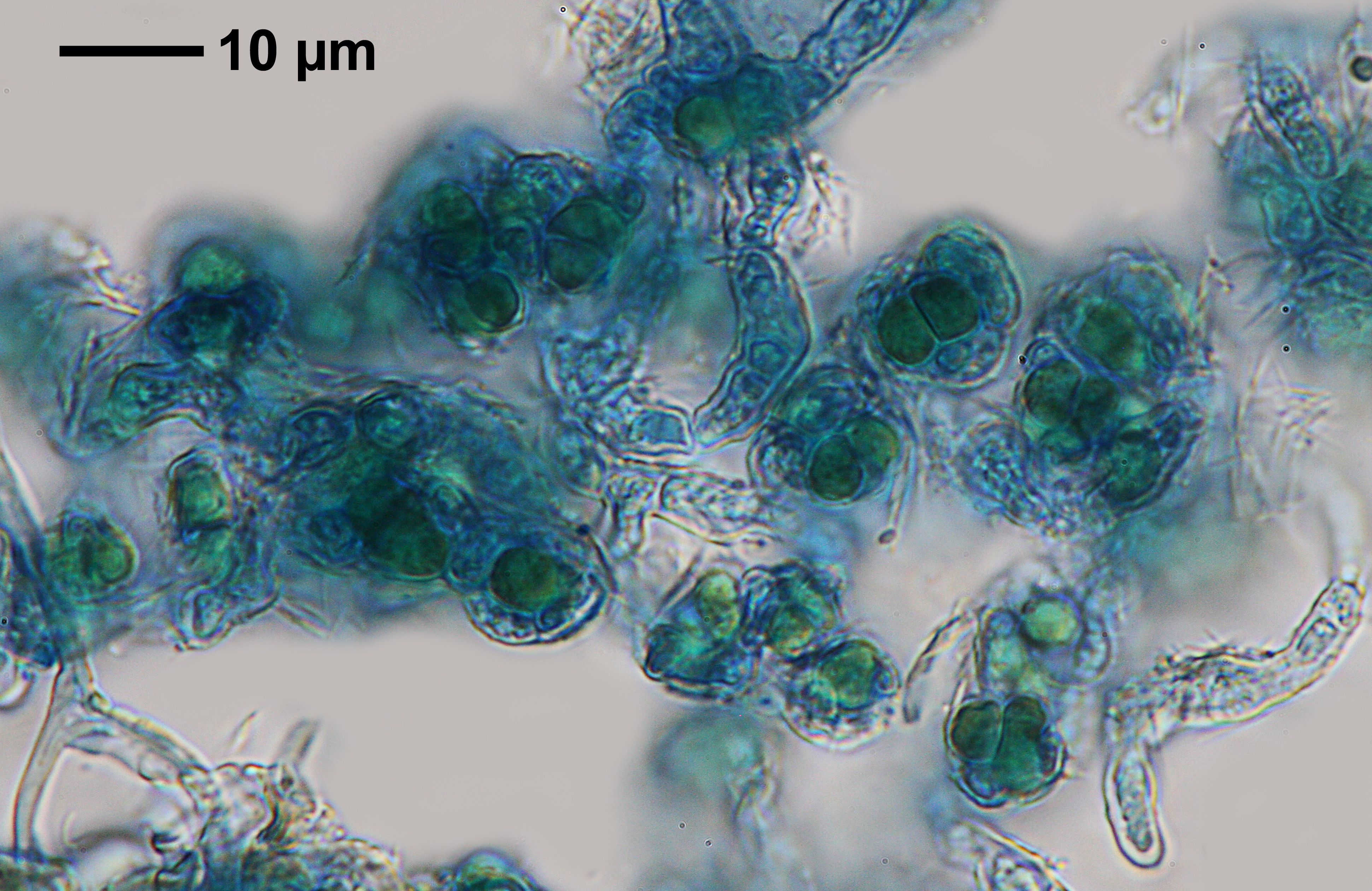
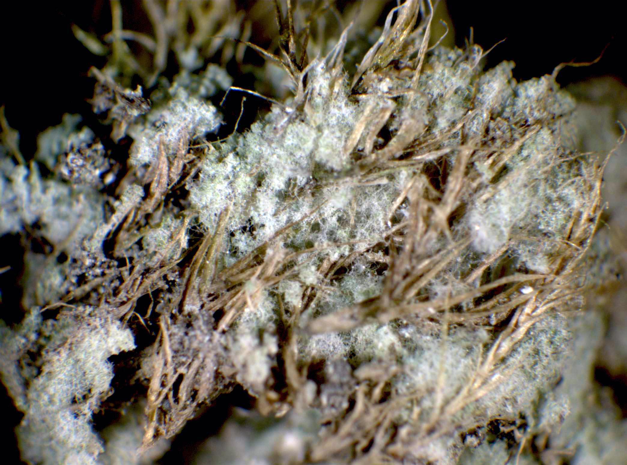
Description: Thallus leprose, byssaceous, cottony, forming 1-3 mm thick, up to several cm wide patches (sometimes 1 dm or more), dull, pale lime-green, entirely composed of a very lax mass of thin-walled, hyaline, anastomosing, 2-3.5 µm thick hyphae with numerous septa, without true soredia-like granules. The hyphae are mainly erect, and bear laterally, in their distal parts, shrub-like clusters of 1-3 algal cells which are up to 15(-20) µm wide, in a form resembling a bunch of grape, not completely enclosed by hyphae. Medulla not evident. Photobiont chlorococcoid, the algal cells mostly spherical, single or forming short filaments of no more than 3 cells, 2.5-6(-10) µm thick, each cell with a nucleus and a parietal cup-shaped chloroplast with lobes, filling more than half of the cell periphery. Spot tests: K-, C-, KC-, P-, UV-. Chemistry: lesdainin (6α-acetoxyhopan-22-ol), and a range of unidentified terpenoids (mostly in traces).
Growth form: Leprose
Photobiont: green algae other than Trentepohlia
Reproductive strategy: mainly asexual, by soredia, or soredia-like structures (e.g. blastidia)
Most common in areas with a humid-warm climate (e.g. most of Tyrrenian Italy)
In underhangs rarely wetted by rain
Commonnes-rarity: (info)
Alpine belt: absent
Subalpine belt: absent
Montane belt: rare
Dry submediterranean belt: rather rare
Humid submediterranean belt: rather rare
Padanian area: absent
pH of the substrata:
1 2 3 4 5

Solar irradiation:
1 2 3 4 5
Aridity:
1 2 3 4 5
Eutrophication:
1 2 3 4 5
Poleotolerance:
0 1 2 3
Altitudinal distribution:
1 2 3 4 5 6
Rarity
absent
extremely rare
very rare
rare
rather rare
rather common
common
very common
extremely common
Loading data...
Occurrence data
Predictive map
Felix Schumm – CC BY-SA 4.0
[14092], Portugal, Azoren, Terceira, bei Sao Bartholomeu 38°40.482' N, 27°17.586' W, 125 m. Leg. Aptroot & Schumm 13.07.2008, det. Aptroot
Felix Schumm – CC BY-SA 4.0
[14092], Portugal, Azoren, Terceira, bei Sao Bartholomeu 38°40.482' N, 27°17.586' W, 125 m. Leg. Aptroot & Schumm 13.07.2008, det. Aptroot
Felix Schumm – CC BY-SA 4.0
[14092], Portugal, Azoren, Terceira, bei Sao Bartholomeu 38°40.482' N, 27°17.586' W, 125 m. Leg. Aptroot & Schumm 13.07.2008, det. Aptroot
Felix Schumm – CC BY-SA 4.0
[14092], Portugal, Azoren, Terceira, bei Sao Bartholomeu 38°40.482' N, 27°17.586' W, 125 m. Leg. Aptroot & Schumm 13.07.2008, det. Aptroot
Felix Schumm – CC BY-SA 4.0
[14092], Portugal, Azoren, Terceira, bei Sao Bartholomeu 38°40.482' N, 27°17.586' W, 125 m. Leg. Aptroot & Schumm 13.07.2008, det. Aptroot

Felix Schumm – CC BY-SA 4.0
[14092], Portugal, Azoren, Terceira, bei Sao Bartholomeu 38°40.482' N, 27°17.586' W, 125 m. Leg. Aptroot & Schumm 13.07.2008, det. Aptroot
Felix Schumm – CC BY-SA 4.0
[14092], Portugal, Azoren, Terceira, bei Sao Bartholomeu 38°40.482' N, 27°17.586' W, 125 m. Leg. Aptroot & Schumm 13.07.2008, det. Aptroot

Felix Schumm – CC BY-SA 4.0
[14092], Portugal, Azoren, Terceira, bei Sao Bartholomeu 38°40.482' N, 27°17.586' W, 125 m. Leg. Aptroot & Schumm 13.07.2008, det. Aptroot

Felix Schumm – CC BY-SA 4.0
[14092], Portugal, Azoren, Terceira, bei Sao Bartholomeu 38°40.482' N, 27°17.586' W, 125 m. Leg. Aptroot & Schumm 13.07.2008, det. Aptroot
Felix Schumm – CC BY-SA 4.0
[14092], Portugal, Azoren, Terceira, bei Sao Bartholomeu 38°40.482' N, 27°17.586' W, 125 m. Leg. Aptroot & Schumm 13.07.2008, det. Aptroot

Felix Schumm – CC BY-SA 4.0
[14092], Portugal, Azoren, Terceira, bei Sao Bartholomeu 38°40.482' N, 27°17.586' W, 125 m. Leg. Aptroot & Schumm 13.07.2008, det. Aptroot

Felix Schumm – CC BY-SA 4.0
[14092], Portugal, Azoren, Terceira, bei Sao Bartholomeu 38°40.482' N, 27°17.586' W, 125 m. Leg. Aptroot & Schumm 13.07.2008, det. Aptroot
Felix Schumm – CC BY-SA 4.0
[14092], Portugal, Azoren, Terceira, bei Sao Bartholomeu 38°40.482' N, 27°17.586' W, 125 m. Leg. Aptroot & Schumm 13.07.2008, det. Aptroot
Felix Schumm – CC BY-SA 4.0
[14092], Portugal, Azoren, Terceira, bei Sao Bartholomeu 38°40.482' N, 27°17.586' W, 125 m. Leg. Aptroot & Schumm 13.07.2008, det. Aptroot
Felix Schumm – CC BY-SA 4.0
[14092], Portugal, Azoren, Terceira, bei Sao Bartholomeu 38°40.482' N, 27°17.586' W, 125 m. Leg. Aptroot & Schumm 13.07.2008, det. Aptroot

Felix Schumm – CC BY-SA 4.0
[14092], Portugal, Azoren, Terceira, bei Sao Bartholomeu 38°40.482' N, 27°17.586' W, 125 m. Leg. Aptroot & Schumm 13.07.2008, det. Aptroot

Felix Schumm – CC BY-SA 4.0
[ABL-69713], Madeira, Funchal, Palheiro (Blandy) Gardens, on basalt, 26°15’ N, 3°25’ E, 450 m. Leg. et det. Aptroot 06.06.2011
Felix Schumm – CC BY-SA 4.0
[ABL-69713], Madeira, Funchal, Palheiro (Blandy) Gardens, on basalt, 26°15’ N, 3°25’ E, 450 m. Leg. et det. Aptroot 06.06.2011
Felix Schumm – CC BY-SA 4.0
[ABL-69713], Madeira, Funchal, Palheiro (Blandy) Gardens, on basalt, 26°15’ N, 3°25’ E, 450 m. Leg. et det. Aptroot 06.06.2011
Felix Schumm – CC BY-SA 4.0
[ABL-69713], Madeira, Funchal, Palheiro (Blandy) Gardens, on basalt, 26°15’ N, 3°25’ E, 450 m. Leg. et det. Aptroot 06.06.2011
Felix Schumm – CC BY-SA 4.0
[ABL-69713], Madeira, Funchal, Palheiro (Blandy) Gardens, on basalt, 26°15’ N, 3°25’ E, 450 m. Leg. et det. Aptroot 06.06.2011

Felix Schumm – CC BY-SA 4.0
[ABL-69713], Madeira, Funchal, Palheiro (Blandy) Gardens, on basalt, 26°15’ N, 3°25’ E, 450 m. Leg. et det. Aptroot 06.06.2011
Felix Schumm – CC BY-SA 4.0
[ABL-69713], Madeira, Funchal, Palheiro (Blandy) Gardens, on basalt, 26°15’ N, 3°25’ E, 450 m. Leg. et det. Aptroot 06.06.2011
Felix Schumm – CC BY-SA 4.0
[ABL-69713], Madeira, Funchal, Palheiro (Blandy) Gardens, on basalt, 26°15’ N, 3°25’ E, 450 m. Leg. et det. Aptroot 06.06.2011

Felix Schumm – CC BY-SA 4.0
[ABL-69713], Madeira, Funchal, Palheiro (Blandy) Gardens, on basalt, 26°15’ N, 3°25’ E, 450 m. Leg. et det. Aptroot 06.06.2011
Felix Schumm – CC BY-SA 4.0
[ABL-69713], Madeira, Funchal, Palheiro (Blandy) Gardens, on basalt, 26°15’ N, 3°25’ E, 450 m. Leg. et det. Aptroot 06.06.2011
Felix Schumm – CC BY-SA 4.0
[ABL-69713], Madeira, Funchal, Palheiro (Blandy) Gardens, on basalt, 26°15’ N, 3°25’ E, 450 m. Leg. et det. Aptroot 06.06.2011
Leif Stridvall - Source: http://www.stridvall.se/lichens/gallery/
Courtesy: Anita Stridvall

P.L. Nimis CC BY-SA 04
TSB 37760
P.L. Nimis CC BY-SA 04
TSB 37760
Manuel Gil
Spain, Canary Islands, Tenerife
Manuel Gil
Spain, Canary Islands, Tenerife
Manuel Gil
Spain, Canary Islands, Tenerife
Growth form: Leprose
Photobiont: green algae other than Trentepohlia
Reproductive strategy: mainly asexual, by soredia, or soredia-like structures (e.g. blastidia)
Most common in areas with a humid-warm climate (e.g. most of Tyrrenian Italy)
In underhangs rarely wetted by rain
Commonnes-rarity: (info)
Alpine belt: absent
Subalpine belt: absent
Montane belt: rare
Dry submediterranean belt: rather rare
Humid submediterranean belt: rather rare
Padanian area: absent
pH of the substrata:
| 1 | 2 | 3 | 4 | 5 |
Solar irradiation:
| 1 | 2 | 3 | 4 | 5 |
Aridity:
| 1 | 2 | 3 | 4 | 5 |
Eutrophication:
| 1 | 2 | 3 | 4 | 5 |
Poleotolerance:
| 0 | 1 | 2 | 3 |
Altitudinal distribution:
| 1 | 2 | 3 | 4 | 5 | 6 |
Rarity
absent
extremely rare
very rare
rare
rather rare
rather common
common
very common
extremely common
Loading data...
Occurrence data
Predictive map

Felix Schumm – CC BY-SA 4.0
[14092], Portugal, Azoren, Terceira, bei Sao Bartholomeu 38°40.482' N, 27°17.586' W, 125 m. Leg. Aptroot & Schumm 13.07.2008, det. Aptroot
Felix Schumm – CC BY-SA 4.0
[14092], Portugal, Azoren, Terceira, bei Sao Bartholomeu 38°40.482' N, 27°17.586' W, 125 m. Leg. Aptroot & Schumm 13.07.2008, det. Aptroot

Felix Schumm – CC BY-SA 4.0
[14092], Portugal, Azoren, Terceira, bei Sao Bartholomeu 38°40.482' N, 27°17.586' W, 125 m. Leg. Aptroot & Schumm 13.07.2008, det. Aptroot

Felix Schumm – CC BY-SA 4.0
[14092], Portugal, Azoren, Terceira, bei Sao Bartholomeu 38°40.482' N, 27°17.586' W, 125 m. Leg. Aptroot & Schumm 13.07.2008, det. Aptroot

Felix Schumm – CC BY-SA 4.0
[14092], Portugal, Azoren, Terceira, bei Sao Bartholomeu 38°40.482' N, 27°17.586' W, 125 m. Leg. Aptroot & Schumm 13.07.2008, det. Aptroot
Felix Schumm – CC BY-SA 4.0
[14092], Portugal, Azoren, Terceira, bei Sao Bartholomeu 38°40.482' N, 27°17.586' W, 125 m. Leg. Aptroot & Schumm 13.07.2008, det. Aptroot

Felix Schumm – CC BY-SA 4.0
[14092], Portugal, Azoren, Terceira, bei Sao Bartholomeu 38°40.482' N, 27°17.586' W, 125 m. Leg. Aptroot & Schumm 13.07.2008, det. Aptroot
Felix Schumm – CC BY-SA 4.0
[14092], Portugal, Azoren, Terceira, bei Sao Bartholomeu 38°40.482' N, 27°17.586' W, 125 m. Leg. Aptroot & Schumm 13.07.2008, det. Aptroot
Felix Schumm – CC BY-SA 4.0
[14092], Portugal, Azoren, Terceira, bei Sao Bartholomeu 38°40.482' N, 27°17.586' W, 125 m. Leg. Aptroot & Schumm 13.07.2008, det. Aptroot

Felix Schumm – CC BY-SA 4.0
[14092], Portugal, Azoren, Terceira, bei Sao Bartholomeu 38°40.482' N, 27°17.586' W, 125 m. Leg. Aptroot & Schumm 13.07.2008, det. Aptroot
Felix Schumm – CC BY-SA 4.0
[14092], Portugal, Azoren, Terceira, bei Sao Bartholomeu 38°40.482' N, 27°17.586' W, 125 m. Leg. Aptroot & Schumm 13.07.2008, det. Aptroot
Felix Schumm – CC BY-SA 4.0
[14092], Portugal, Azoren, Terceira, bei Sao Bartholomeu 38°40.482' N, 27°17.586' W, 125 m. Leg. Aptroot & Schumm 13.07.2008, det. Aptroot

Felix Schumm – CC BY-SA 4.0
[14092], Portugal, Azoren, Terceira, bei Sao Bartholomeu 38°40.482' N, 27°17.586' W, 125 m. Leg. Aptroot & Schumm 13.07.2008, det. Aptroot

Felix Schumm – CC BY-SA 4.0
[14092], Portugal, Azoren, Terceira, bei Sao Bartholomeu 38°40.482' N, 27°17.586' W, 125 m. Leg. Aptroot & Schumm 13.07.2008, det. Aptroot
Felix Schumm – CC BY-SA 4.0
[14092], Portugal, Azoren, Terceira, bei Sao Bartholomeu 38°40.482' N, 27°17.586' W, 125 m. Leg. Aptroot & Schumm 13.07.2008, det. Aptroot
Felix Schumm – CC BY-SA 4.0
[14092], Portugal, Azoren, Terceira, bei Sao Bartholomeu 38°40.482' N, 27°17.586' W, 125 m. Leg. Aptroot & Schumm 13.07.2008, det. Aptroot
Felix Schumm – CC BY-SA 4.0
[ABL-69713], Madeira, Funchal, Palheiro (Blandy) Gardens, on basalt, 26°15’ N, 3°25’ E, 450 m. Leg. et det. Aptroot 06.06.2011

Felix Schumm – CC BY-SA 4.0
[ABL-69713], Madeira, Funchal, Palheiro (Blandy) Gardens, on basalt, 26°15’ N, 3°25’ E, 450 m. Leg. et det. Aptroot 06.06.2011

Felix Schumm – CC BY-SA 4.0
[ABL-69713], Madeira, Funchal, Palheiro (Blandy) Gardens, on basalt, 26°15’ N, 3°25’ E, 450 m. Leg. et det. Aptroot 06.06.2011
Felix Schumm – CC BY-SA 4.0
[ABL-69713], Madeira, Funchal, Palheiro (Blandy) Gardens, on basalt, 26°15’ N, 3°25’ E, 450 m. Leg. et det. Aptroot 06.06.2011

Felix Schumm – CC BY-SA 4.0
[ABL-69713], Madeira, Funchal, Palheiro (Blandy) Gardens, on basalt, 26°15’ N, 3°25’ E, 450 m. Leg. et det. Aptroot 06.06.2011
Felix Schumm – CC BY-SA 4.0
[ABL-69713], Madeira, Funchal, Palheiro (Blandy) Gardens, on basalt, 26°15’ N, 3°25’ E, 450 m. Leg. et det. Aptroot 06.06.2011

Felix Schumm – CC BY-SA 4.0
[ABL-69713], Madeira, Funchal, Palheiro (Blandy) Gardens, on basalt, 26°15’ N, 3°25’ E, 450 m. Leg. et det. Aptroot 06.06.2011

Felix Schumm – CC BY-SA 4.0
[ABL-69713], Madeira, Funchal, Palheiro (Blandy) Gardens, on basalt, 26°15’ N, 3°25’ E, 450 m. Leg. et det. Aptroot 06.06.2011
Felix Schumm – CC BY-SA 4.0
[ABL-69713], Madeira, Funchal, Palheiro (Blandy) Gardens, on basalt, 26°15’ N, 3°25’ E, 450 m. Leg. et det. Aptroot 06.06.2011
Felix Schumm – CC BY-SA 4.0
[ABL-69713], Madeira, Funchal, Palheiro (Blandy) Gardens, on basalt, 26°15’ N, 3°25’ E, 450 m. Leg. et det. Aptroot 06.06.2011

Felix Schumm – CC BY-SA 4.0
[ABL-69713], Madeira, Funchal, Palheiro (Blandy) Gardens, on basalt, 26°15’ N, 3°25’ E, 450 m. Leg. et det. Aptroot 06.06.2011

Leif Stridvall - Source: http://www.stridvall.se/lichens/gallery/
Courtesy: Anita Stridvall
P.L. Nimis CC BY-SA 04
TSB 37760

P.L. Nimis CC BY-SA 04
TSB 37760

Manuel Gil
Spain, Canary Islands, Tenerife

Manuel Gil
Spain, Canary Islands, Tenerife


