Buellia griseovirens (Sm.) Almb.
Bot. Not.: 246, 1952. Basionym: Variolaria griseovirens Turner & Borrer ex Sm. in Smith & Sowerby - Engl. Bot., 34: tab. 2400, 1812.
Synonyms: Aplotomma turgidum (A. Massal.) A. Massal. ex Beltr.; Buellia betulina (Hepp) Th. Fr.; Buellia elenkinii Tomin; Buellia turgida (A. Massal.) Lettau; Diplotomma betulinum (Hepp) Arnold; Diplotomma turgidum A. Massal.; Rhizocarpon betulinum (Hepp) Zwackh; Rhizocarpon efflorescens Th. Fr.
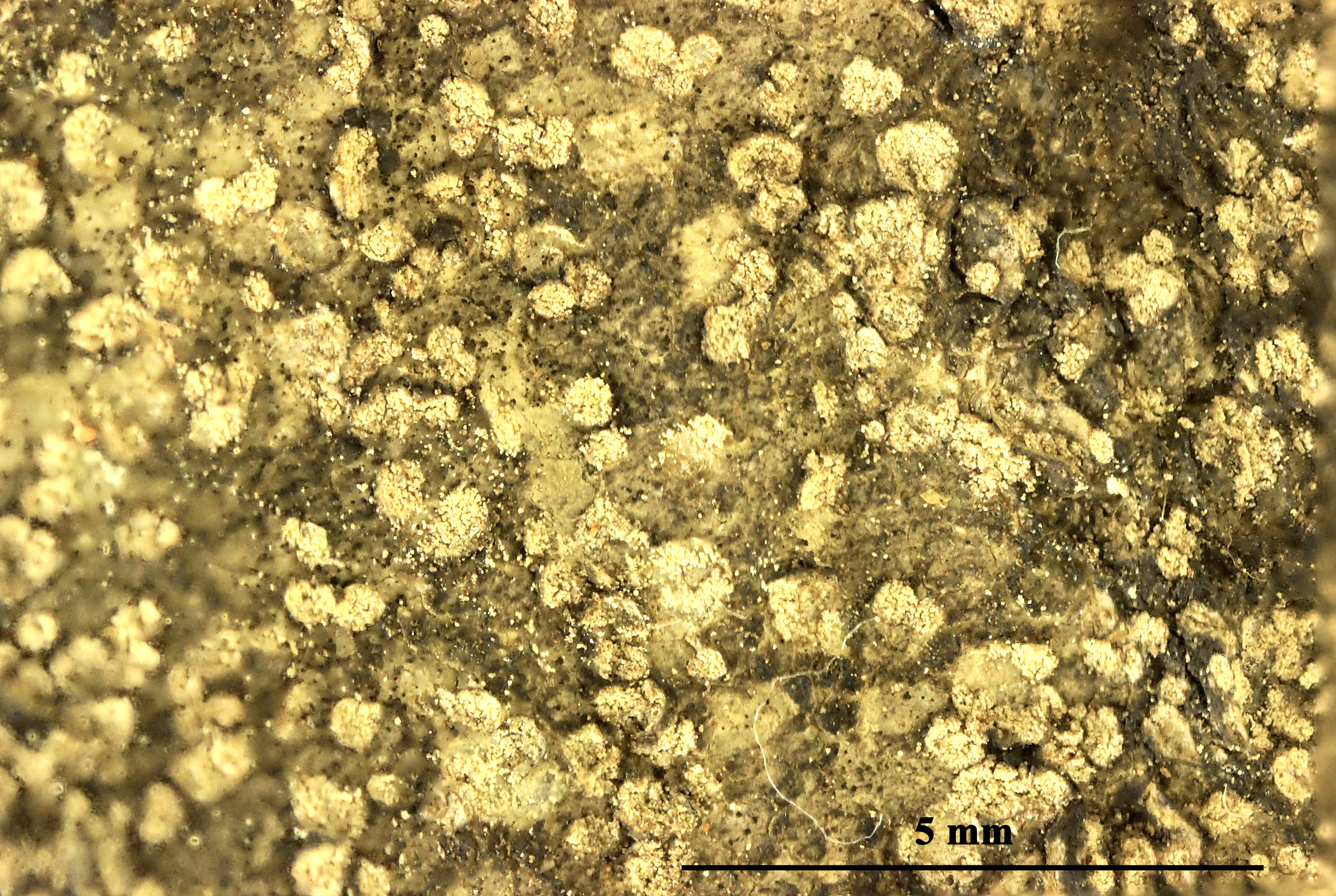
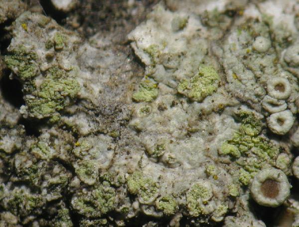
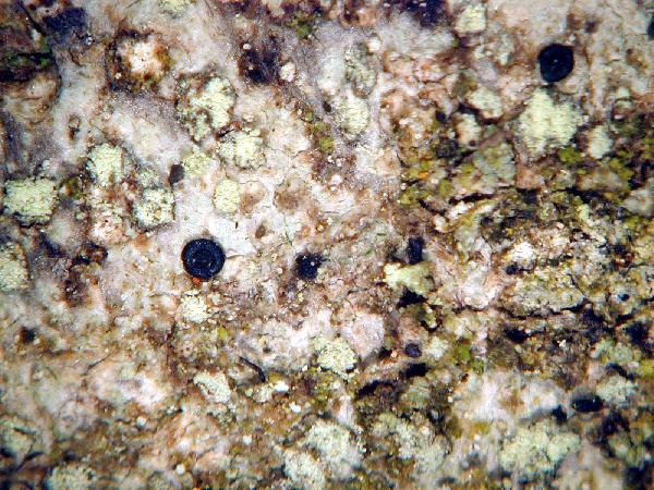
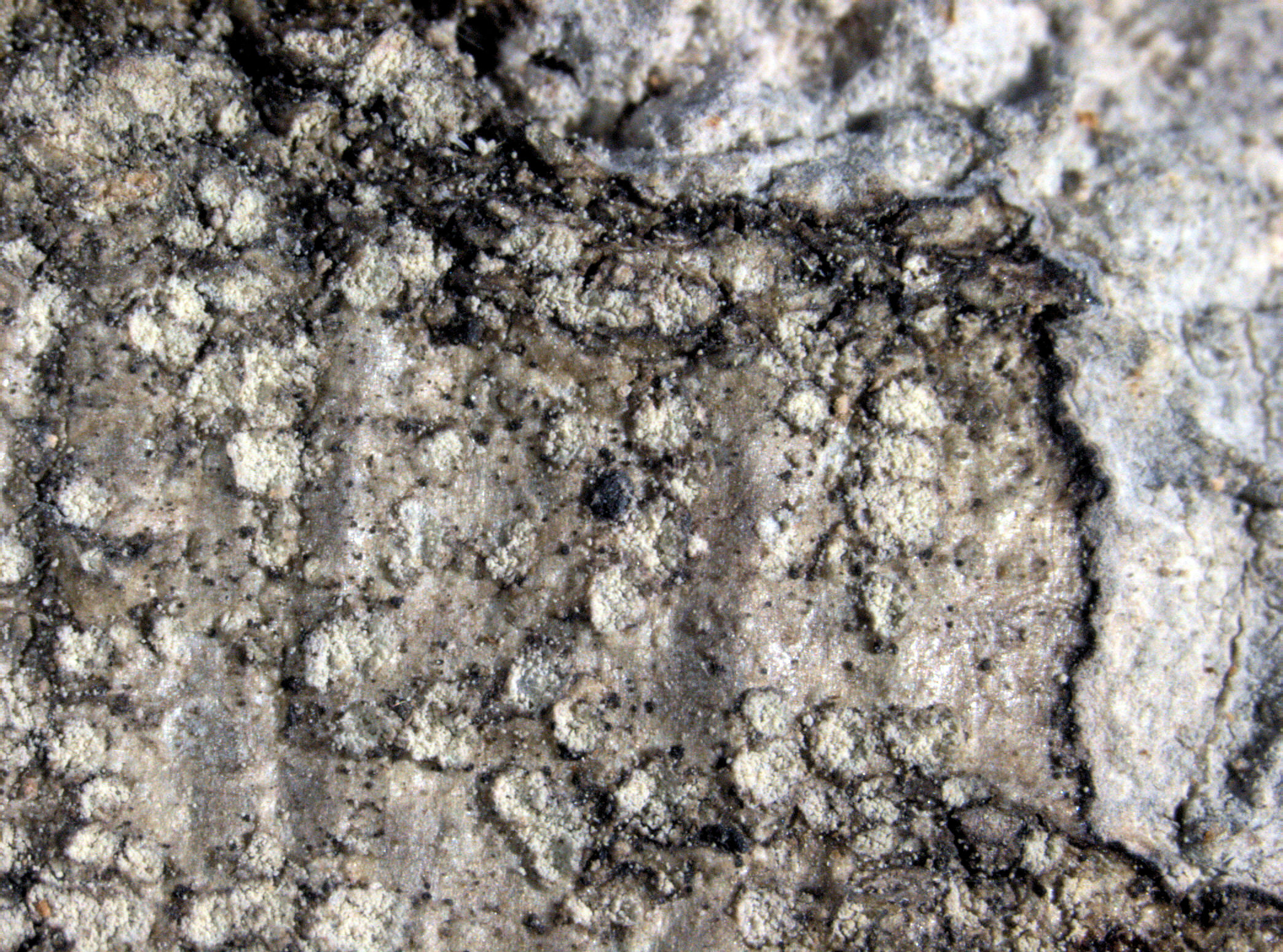
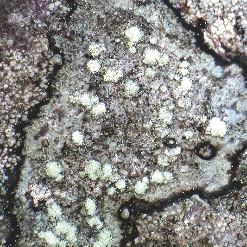
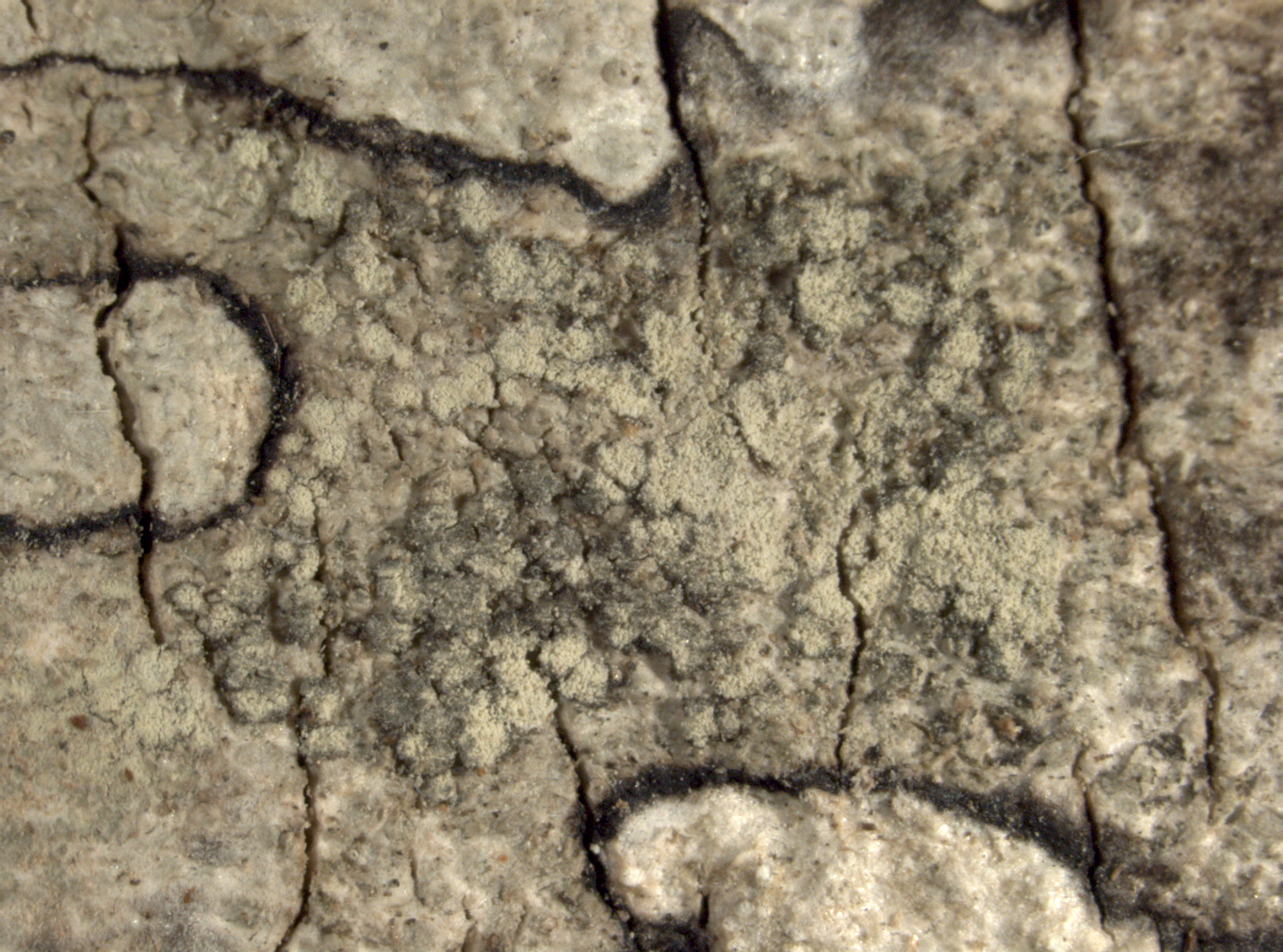
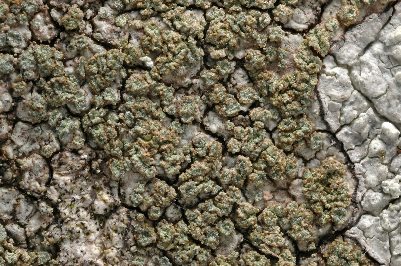
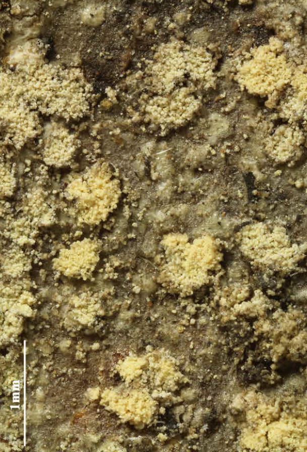
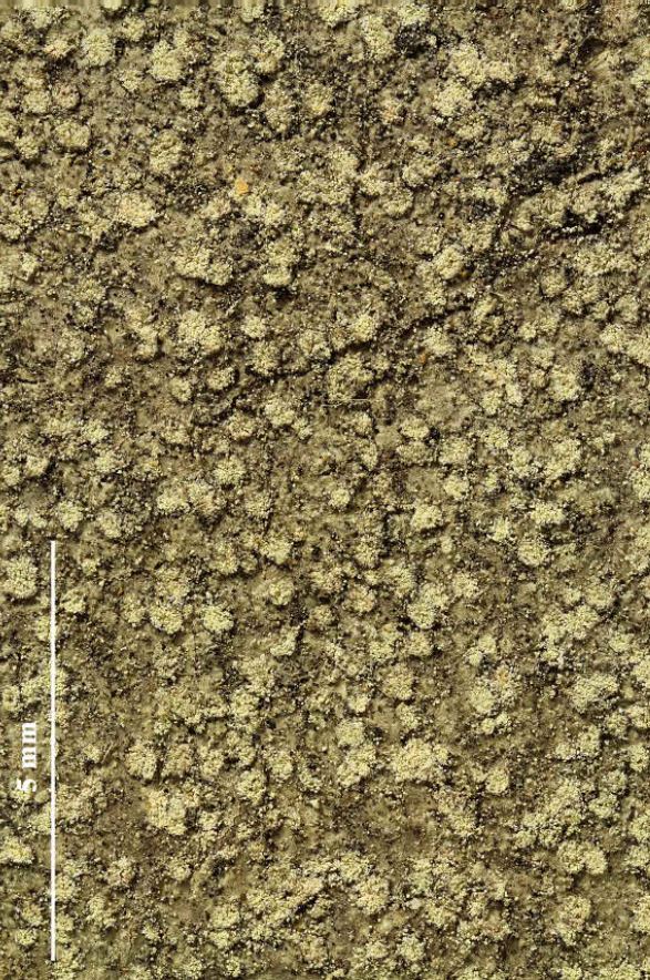
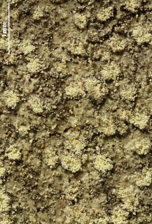
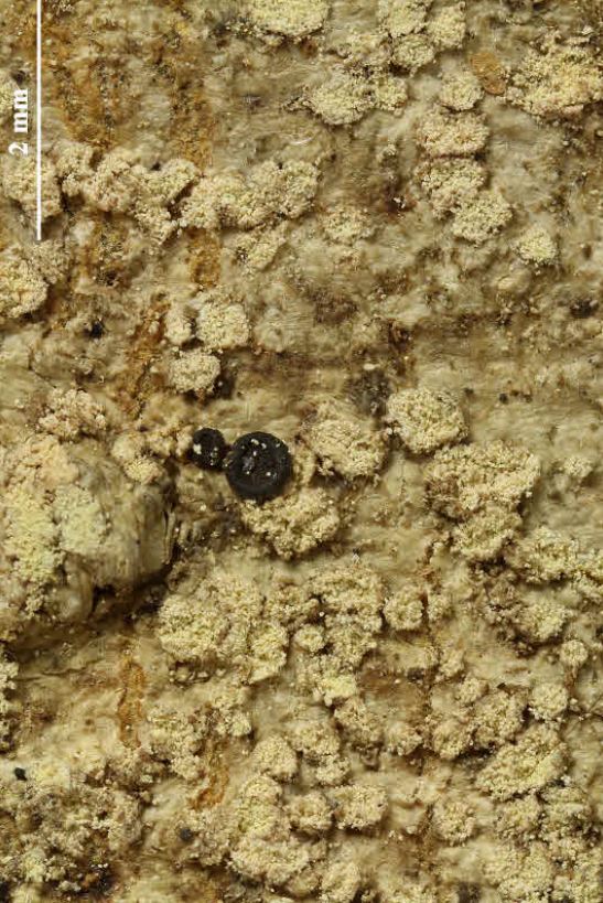
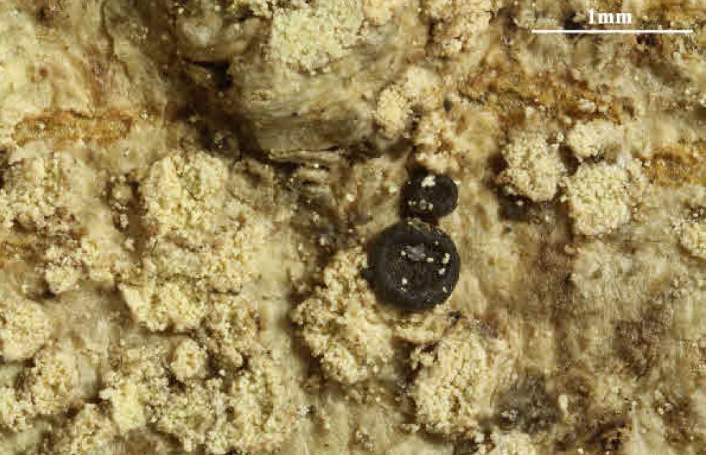
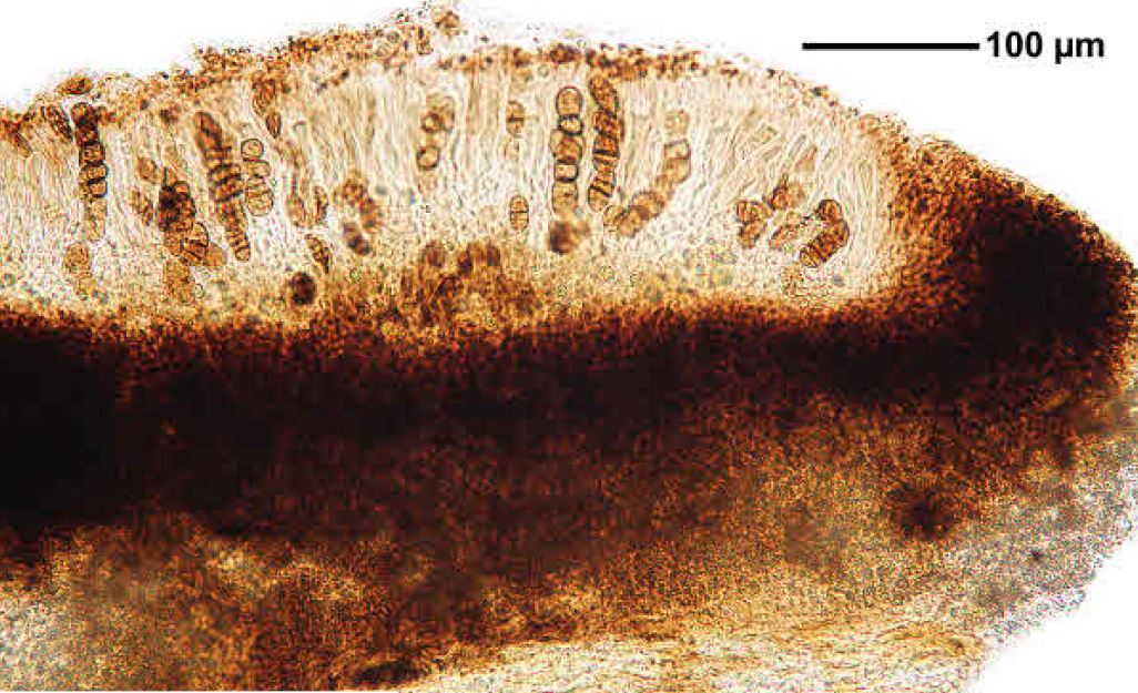
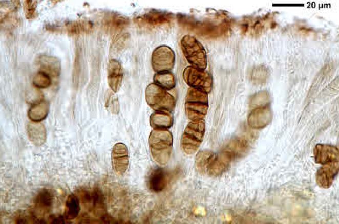
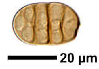
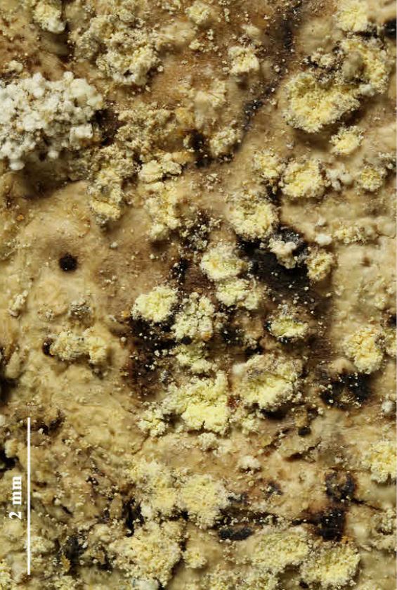
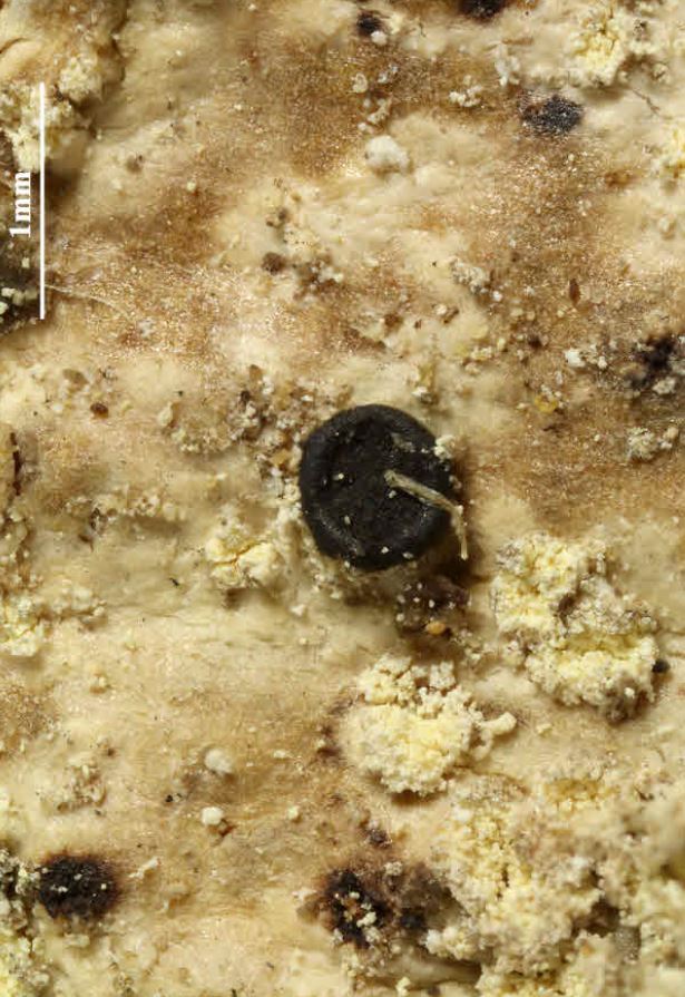
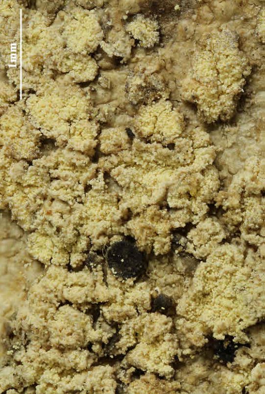
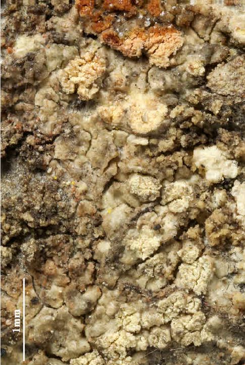
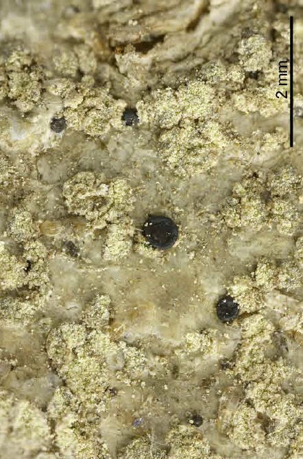
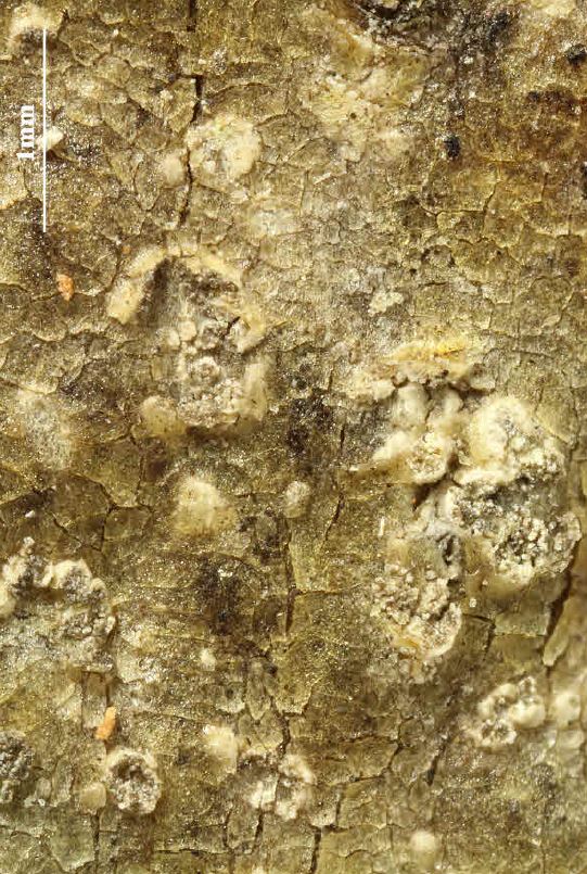
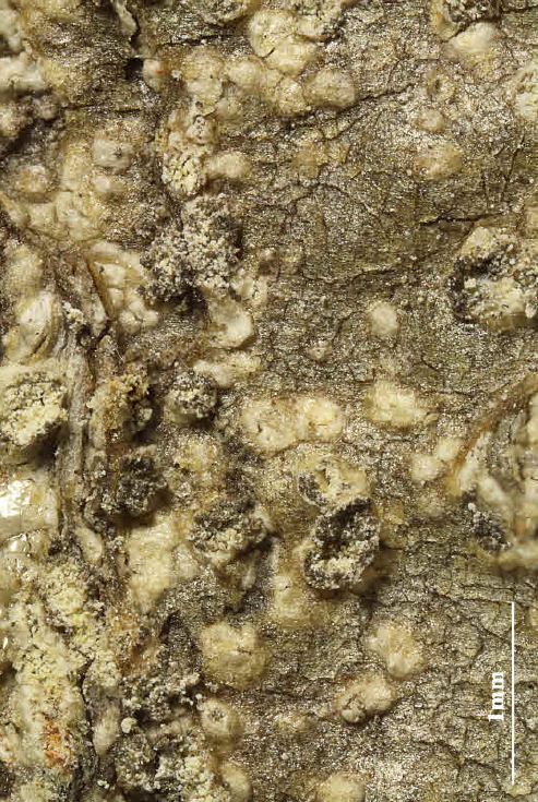
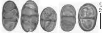
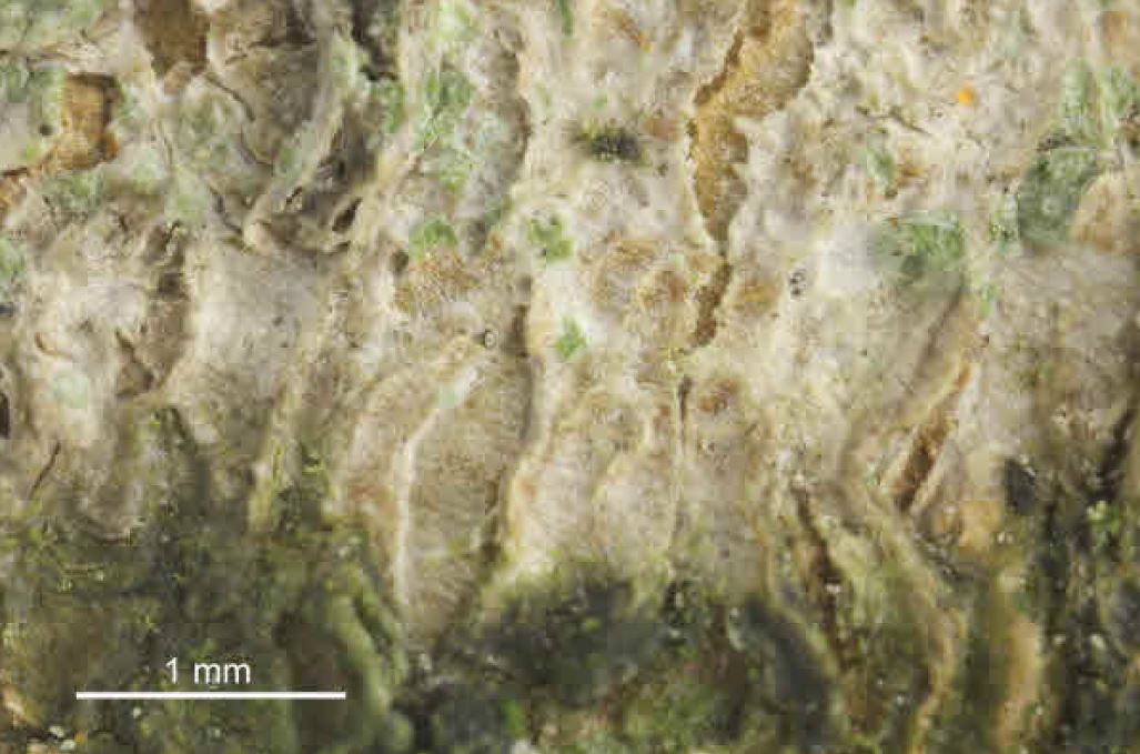
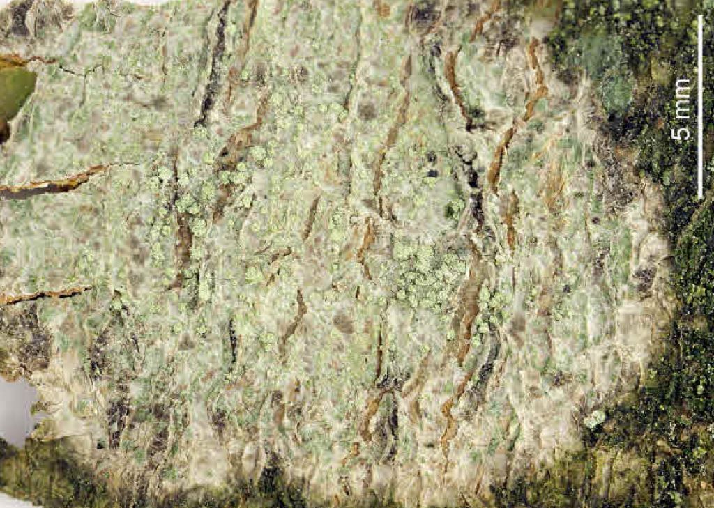
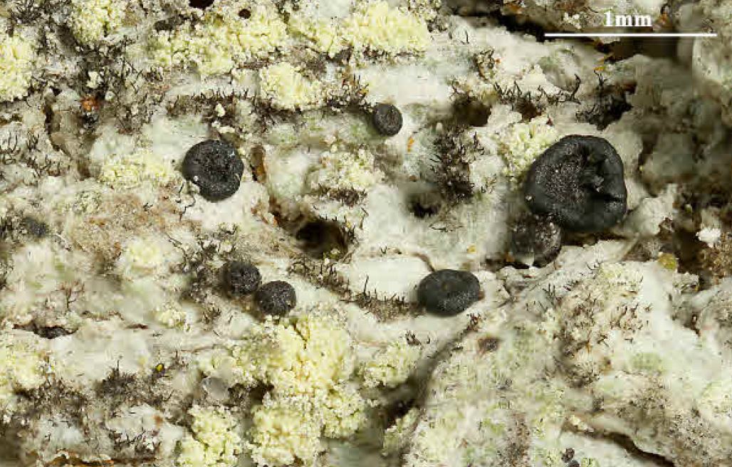
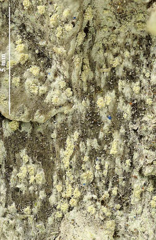
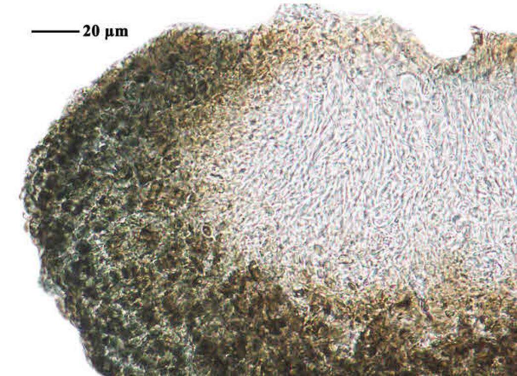
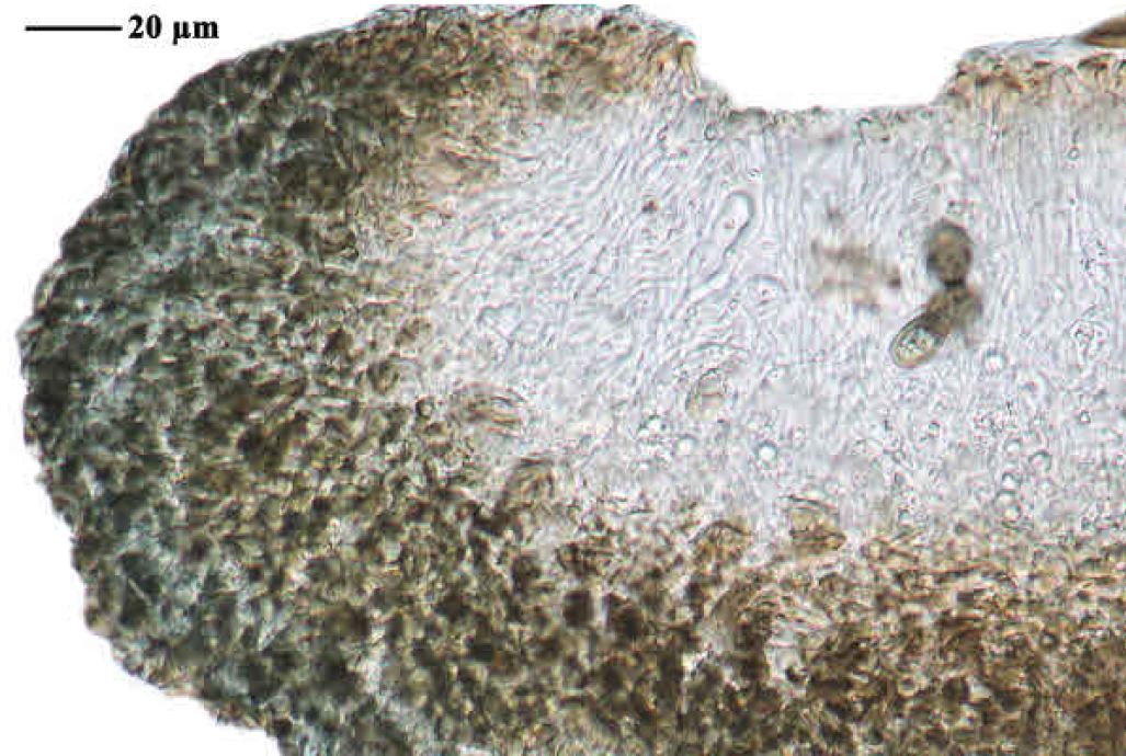
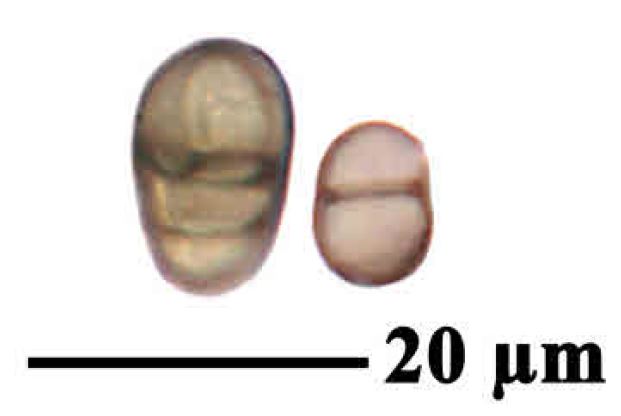
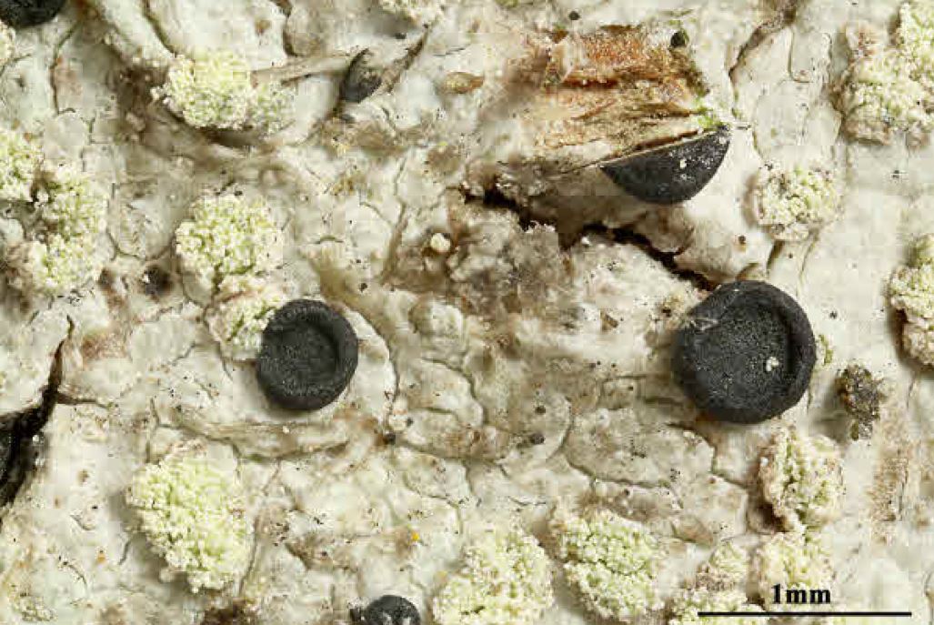
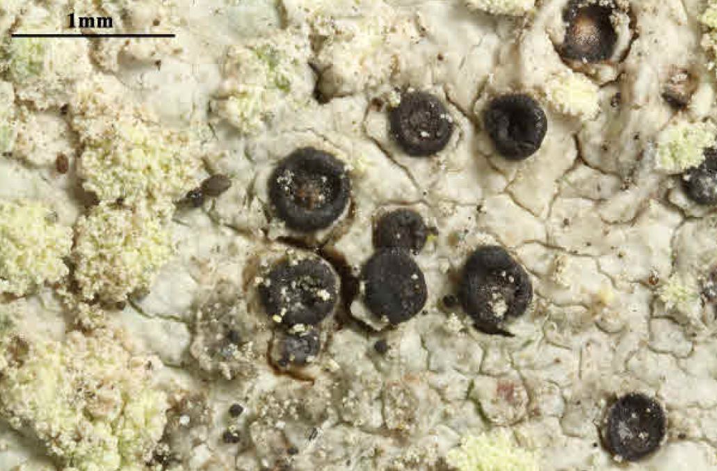
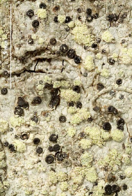
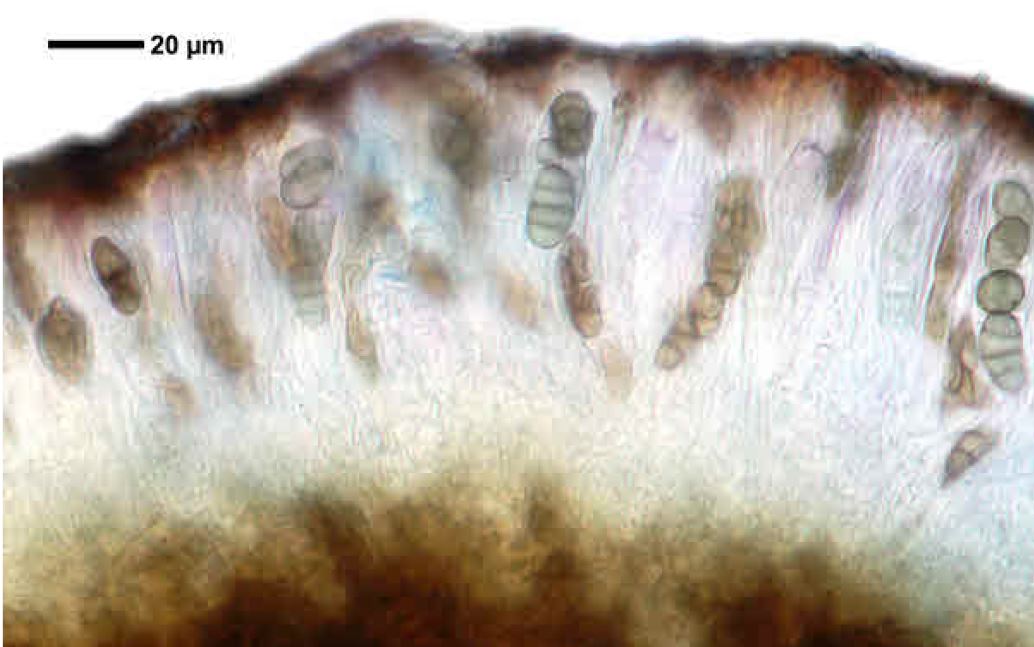
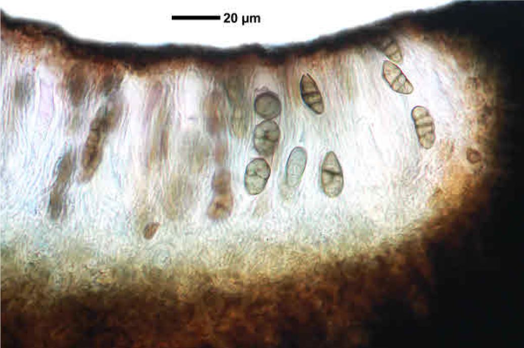
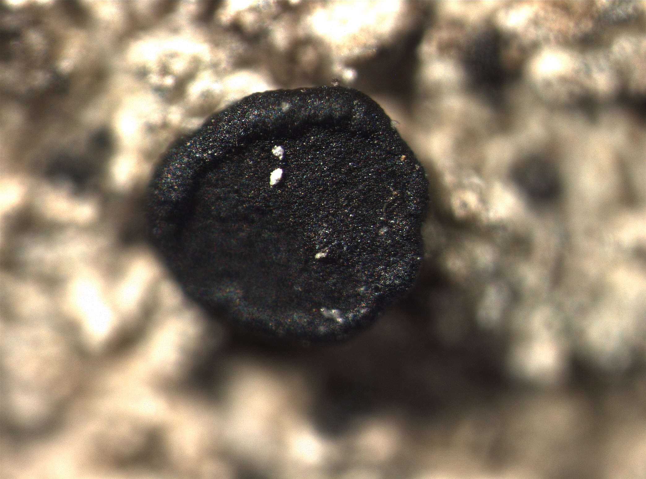
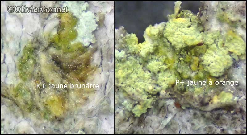
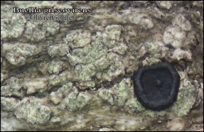
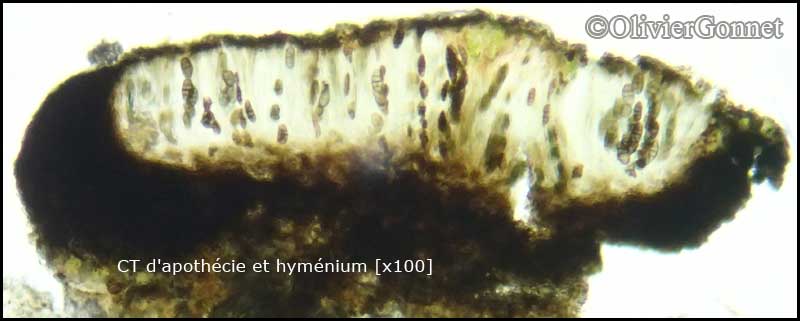
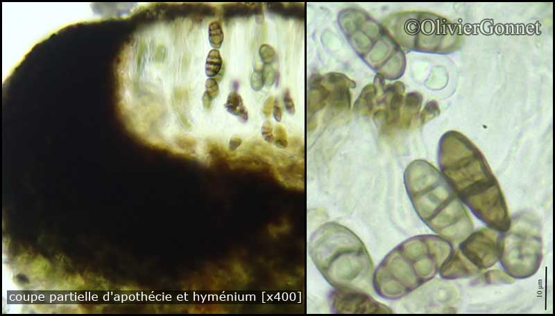
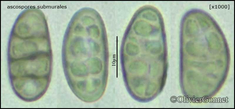
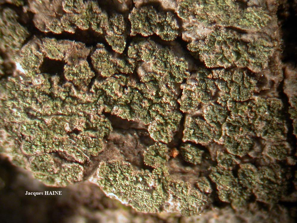
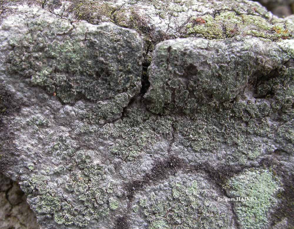
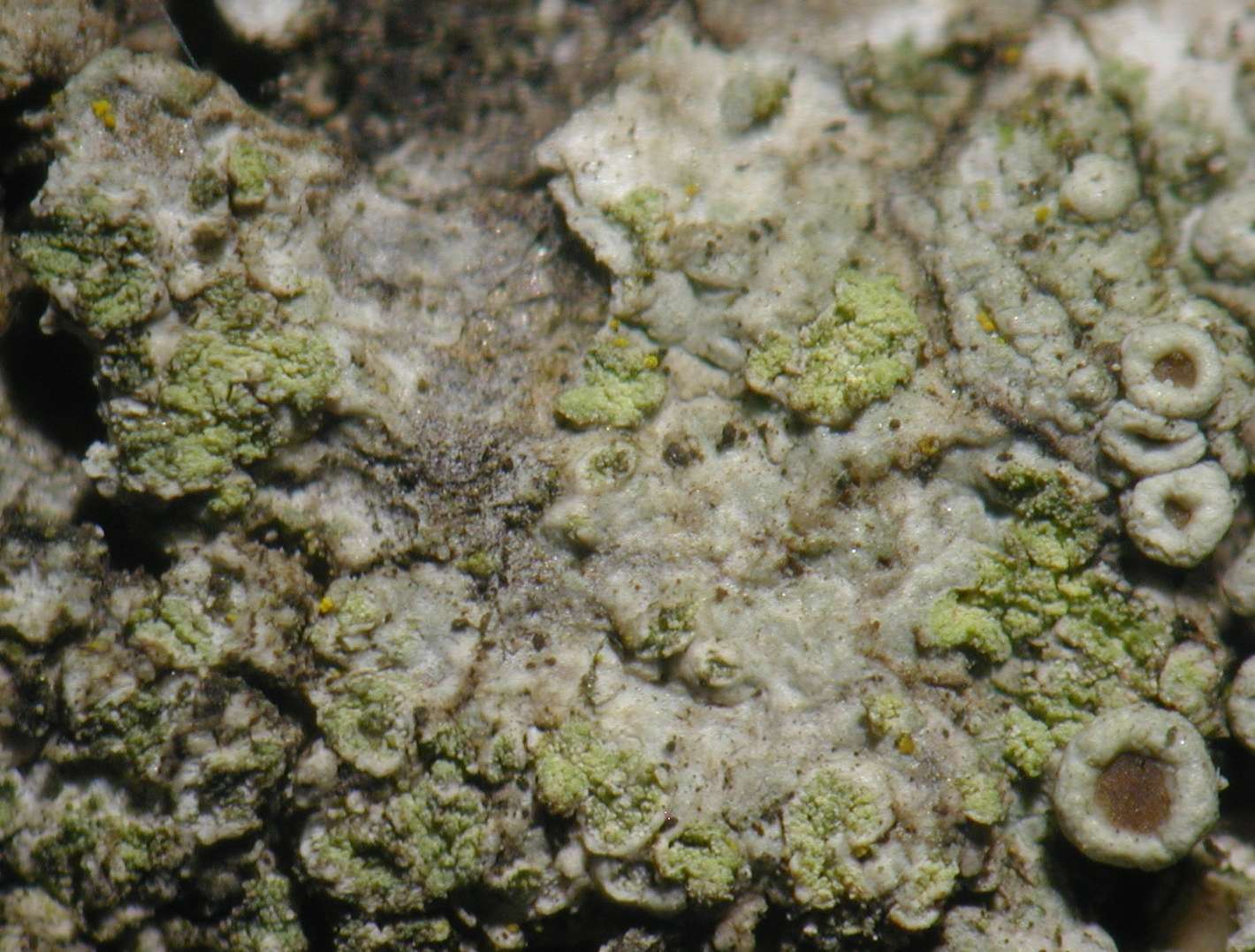
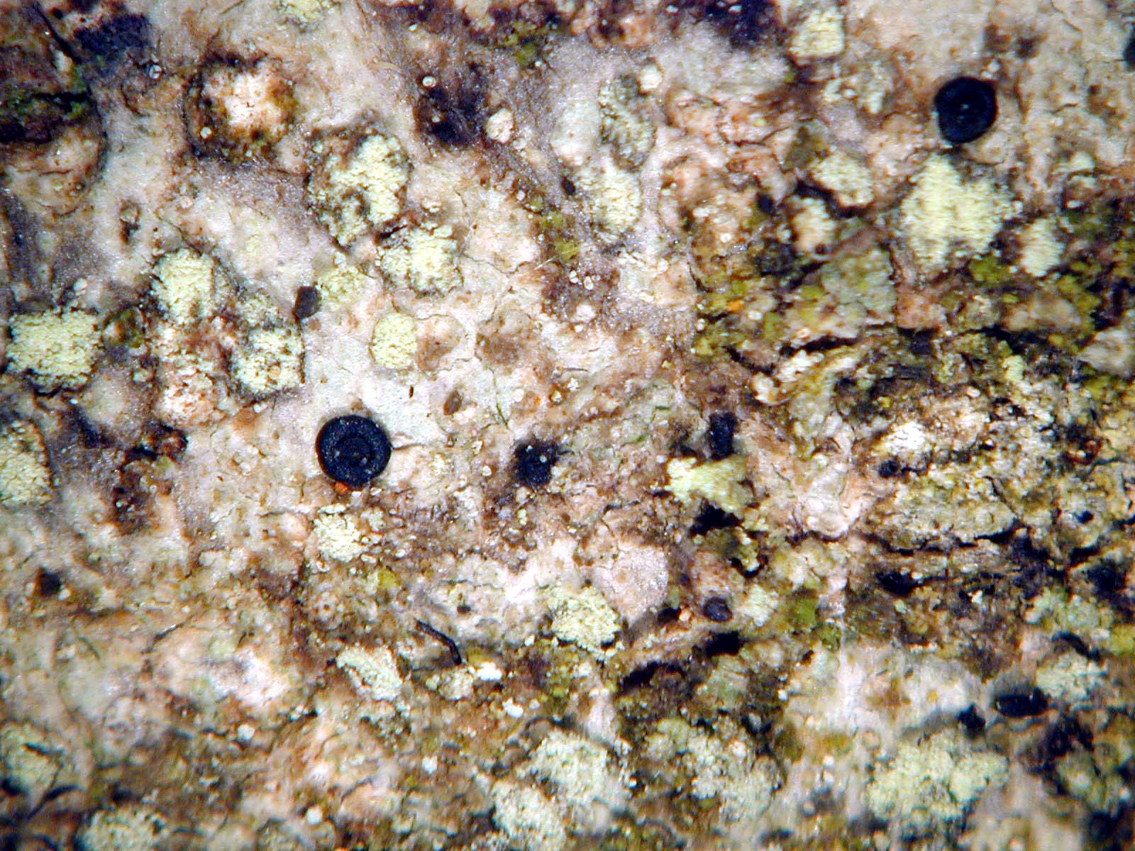
Description: Thallus crustose, continuous to rimose, mostly episubstratic, grey-white, pale grey-brown to greenish grey, delimited by a dark prothallus, with abundant, discrete, rounded, (0.1-)0.2-0.4 mm wide, bluish grey, greenish or pale yellow (when abraded) soralia bearing 15-25 µm wide, farinose soredia. Medulla white, lacking calcium oxalate crystals, non-amyloid. Apothecia rare, lecideine, sessile, 0.3-1(-1.5) mm across, with a black, epruinose, concave to slightly convex disc and a black, thick, persistent proper margin. Proper exciple 80-120 µm wide laterally, dark brown outer part, pale in the intermediate part, and dark brown in inner part with carbonized cells (K+ yellow, N-); epithecium brown; hymenium colourless, not inspersed with oil droplets.80-100(-120) µm high; paraphyses with swollen tips (c. 6 µm wide), and distinct apical caps; hypothecium dark, up to 240 µm high, K+ yellow, N-. Asci 8-spored, clavate to cylindrical-clavate, the apical dome K/I+ dark blue with a pale, conical-pointed apical cushion (axial mass), the wall I-, but the thin outer gel I+ blue, Bacidia-type. Ascospores at first 3-septate, then submuriform with 8-12 cells in optical view, brown, ellipsoid, (13-)18-25(-28) x (7-)9-12(-13.5) µm, the wall with a microrugulate ornamentation. Pycnidia rare, black, with a projecting uppermost part, the wall pigmented in upper part. Conidia bacilliform, 4-6 x 1 µm. Photobiont chlorococcoid. Spot tests: thallus and soralia K+ yellow turning red (needle-like crystals), but sometimes K+ yellow to orange, C- or rarely C+ yellow, KC-, P+ yellow-orange, UV- (very rarely UV+ orange). Chemistry: atranorin (major), norstictic acid (major), connorstictic acid (traces), unknowns.
Growth form: Crustose
Substrata: bark
Photobiont: green algae other than Trentepohlia
Reproductive strategy: mainly asexual, by soredia, or soredia-like structures (e.g. blastidia)
Most common in areas with a humid-warm climate (e.g. most of Tyrrenian Italy)
Commonnes-rarity: (info)
Alpine belt: absent
Subalpine belt: absent
Montane belt: rather rare
Dry submediterranean belt: rather common
Humid submediterranean belt: common
Padanian area: extremely rare
pH of the substrata:
1 2 3 4 5

Solar irradiation:
1 2 3 4 5
Aridity:
1 2 3 4 5
Eutrophication:
1 2 3 4 5
Poleotolerance:
0 1 2 3
Altitudinal distribution:
1 2 3 4 5 6
Rarity
absent
extremely rare
very rare
rare
rather rare
rather common
common
very common
extremely common
Loading data...
Occurrence data
Predictive map
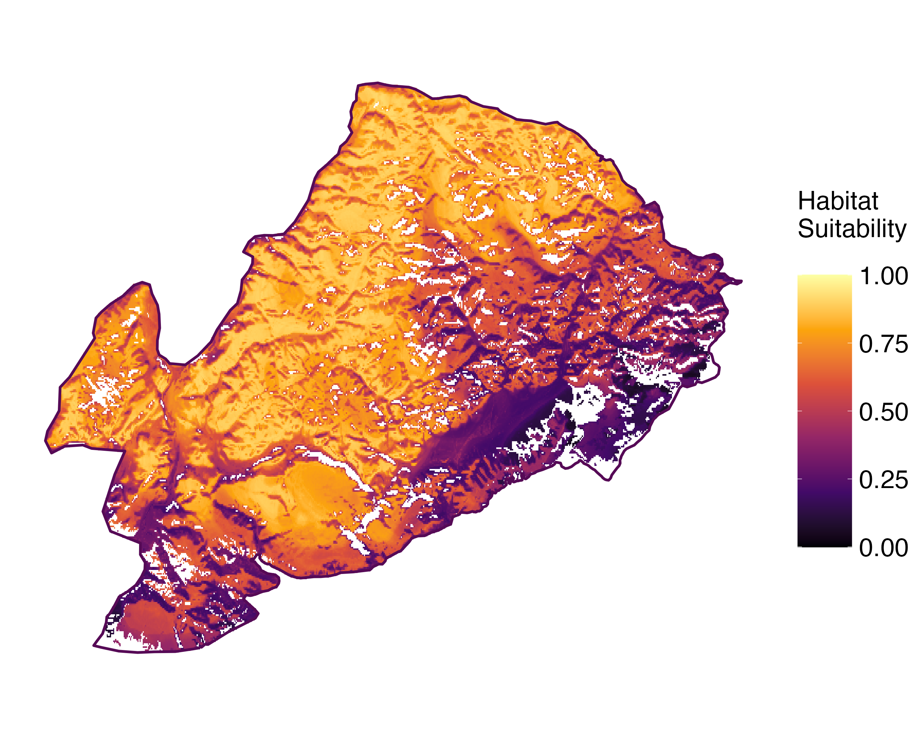 Current prediction (1981-2010)
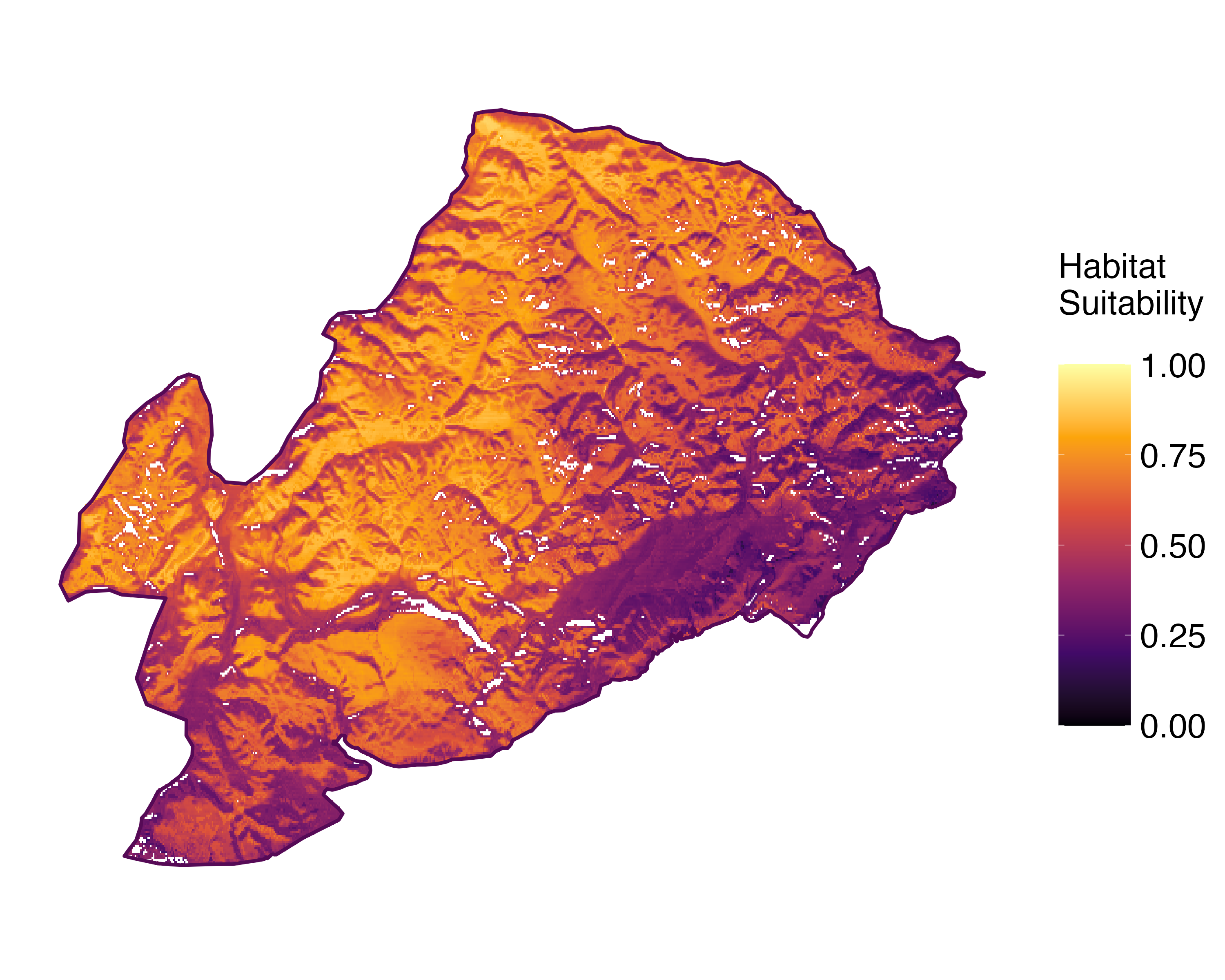 Future prediction (2071-2100) SSP 1-2.6
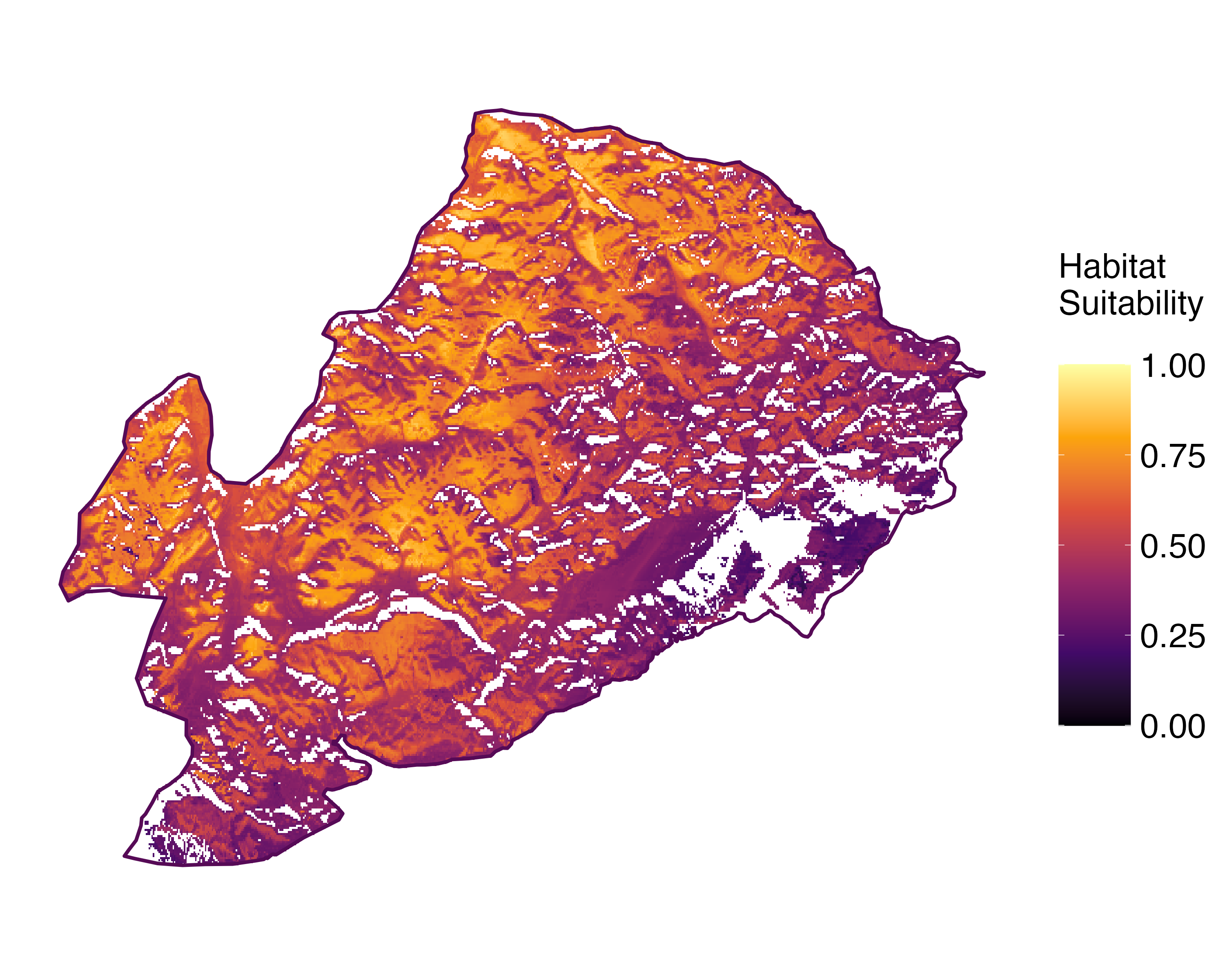 Future prediction (2071-2100) SSP 5-8.5Predictive maps according to Francesconi et al. 2025
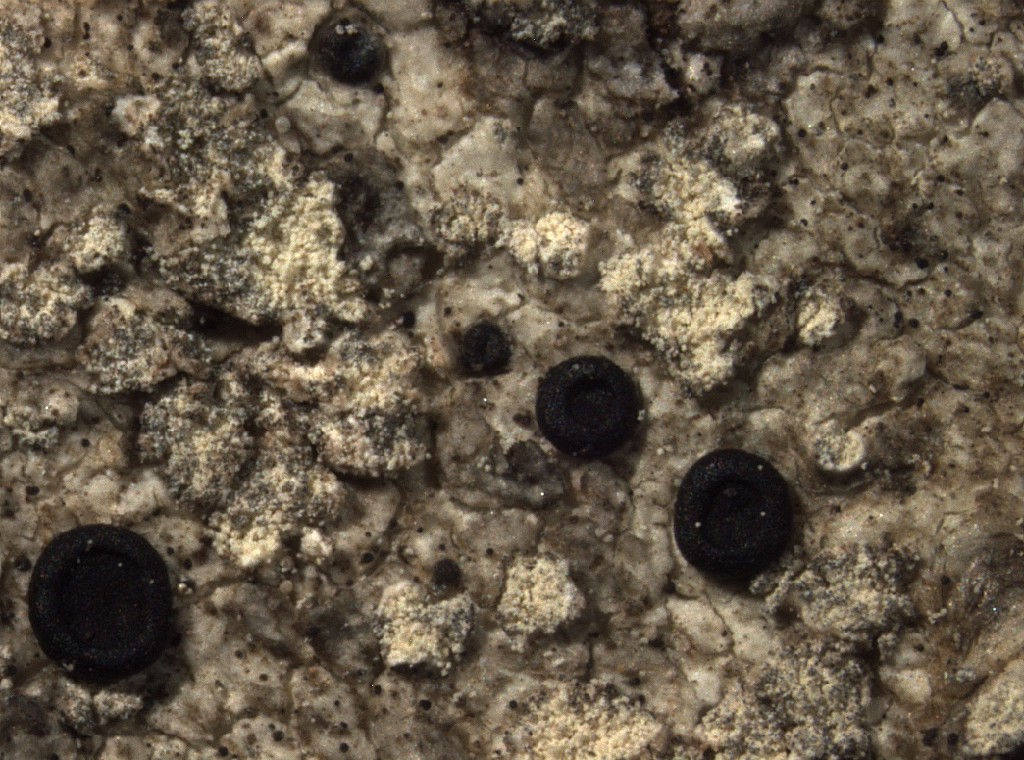
E. Pittao CC BY-SA 4.0
TSB TSB 9334

Andres Saag; Owner: University of Tartu
originally as Buellia griseovirens

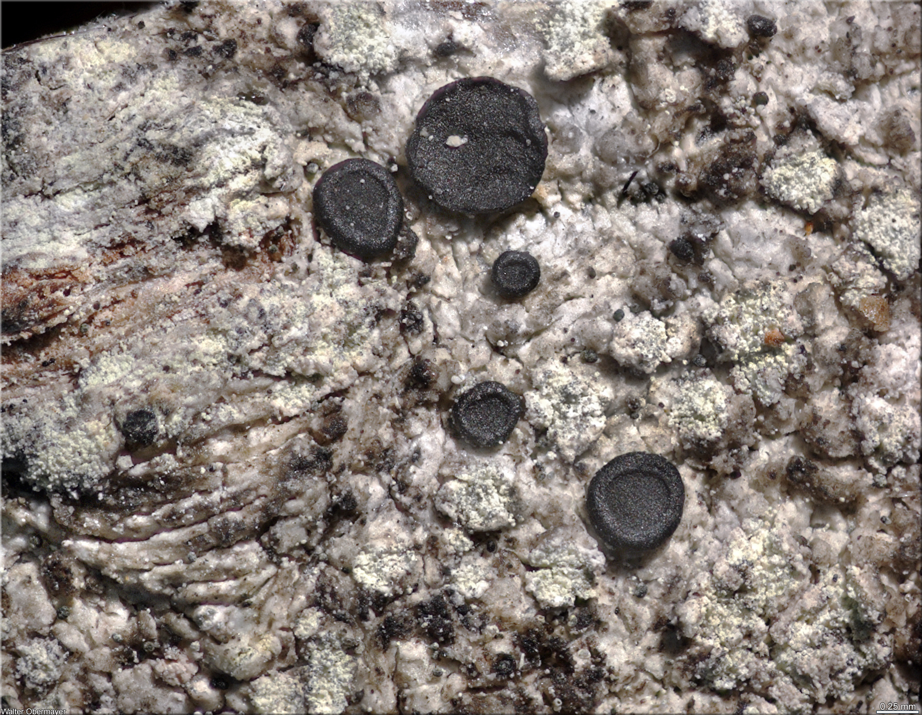
E. Pittao; Owner: Department of Life Sciences, University of Trieste
Herbarium: TSB (TSB 21999)
20.10.2009

Leif Stridvall - Source: http://www.stridvall.se/la/galleries.php (Courtesy: Anita Stridvall)

Felix Schumm – CC BY-SA 4.0
[2329], Germany, Baden-Württemberg, Schwarzwald, im Spitalwald bei Herrenberg, TK 7419. Leg. et det. V. Wirth 08.05.1976

Felix Schumm – CC BY-SA 4.0
[2329], Germany, Baden-Württemberg, Schwarzwald, im Spitalwald bei Herrenberg, TK 7419. Leg. et det. V. Wirth 08.05.1976

Felix Schumm – CC BY-SA 4.0
[2329], Germany, Baden-Württemberg, Schwarzwald, im Spitalwald bei Herrenberg, TK 7419. Leg. et det. V. Wirth 08.05.1976

Felix Schumm – CC BY-SA 4.0
[2804], Germany, Baden-Württemberg, Im Tannbachtal westlich von Schwäbisch Gmünd an Laubholz, TK 7224/ leg. F. Schumm, Tobies, Payerl 24.03.1980, det F.Schumm

Felix Schumm – CC BY-SA 4.0
[2804], Germany, Baden-Württemberg, Im Tannbachtal westlich von Schwäbisch Gmünd an Laubholz, TK 7224/ leg. F. Schumm, Tobies, Payerl 24.03.1980, det F.Schumm

Felix Schumm – CC BY-SA 4.0
[2804], Germany, Baden-Württemberg, Im Tannbachtal westlich von Schwäbisch Gmünd an Laubholz, TK 7224/ leg. F. Schumm, Tobies, Payerl 24.03.1980, det F.Schumm

Felix Schumm – CC BY-SA 4.0
[2804], Germany, Baden-Württemberg, Im Tannbachtal westlich von Schwäbisch Gmünd an Laubholz, TK 7224/ leg. F. Schumm, Tobies, Payerl 24.03.1980, det F.Schumm

Felix Schumm – CC BY-SA 4.0
[2804], Germany, Baden-Württemberg, Im Tannbachtal westlich von Schwäbisch Gmünd an Laubholz, TK 7224/ leg. F. Schumm, Tobies, Payerl 24.03.1980, det F.Schumm

Felix Schumm – CC BY-SA 4.0
[4040], Germany, Baden-Württemberg, Kreis Göppingen, Marbachtal zwischen Börtlingen und Birenbach, an Fraxinus im Laubwald, ca. 360 m, TK 7223. Leg. et det. F. Schumm 18.04.1993.

Felix Schumm – CC BY-SA 4.0
[4040], Germany, Baden-Württemberg, Kreis Göppingen, Marbachtal zwischen Börtlingen und Birenbach, an Fraxinus im Laubwald, ca. 360 m, TK 7223. Leg. et det. F. Schumm 18.04.1993.

Felix Schumm – CC BY-SA 4.0
[4216], Germany, Baden-Württemberg, Kreis Schwäbisch Gmünd, im Beutenbachtal bei der Beutenmühle ca. 3 km südöstlich von Lorch, ca 310 m, an Fraxinus, TK 7224. Leg. et det. F. Schumm 29.05.1995

Felix Schumm – CC BY-SA 4.0
[4216], Germany, Baden-Württemberg, Kreis Schwäbisch Gmünd, im Beutenbachtal bei der Beutenmühle ca. 3 km südöstlich von Lorch, ca 310 m, an Fraxinus, TK 7224. Leg. et det. F. Schumm 29.05.1995

Felix Schumm – CC BY-SA 4.0
[4426], Germany, Baden-Württemberg, Rems-Murr-Kreis, Schorndorf, Eichenbachhang mit Viehweide, sonnige warme Streuobstwiesen, ca. 340 m, an Obstbäumen, TK 7223. Leg. et det. F. Schumm 25.03.1990

Felix Schumm – CC BY-SA 4.0
[4426], Germany, Baden-Württemberg, Rems-Murr-Kreis, Schorndorf, Eichenbachhang mit Viehweide, sonnige warme Streuobstwiesen, ca. 340 m, an Obstbäumen, TK 7223. Leg. et det. F. Schumm 25.03.1990

Felix Schumm – CC BY-SA 4.0
[6981], Germany, Baden-Württemberg, Kreis Göppingen, Marbachtal bei Zell-Börtlingen. An Eschen in Bachnähe, luftfeucht, lichtoffen, ca. 350 m, TK 7223. Leg. F. Schumm & U. Schwarz 24.04.2000, det. F. Schumm 03.05.2000.

Felix Schumm – CC BY-SA 4.0
[6981], Germany, Baden-Württemberg, Kreis Göppingen, Marbachtal bei Zell-Börtlingen. An Eschen in Bachnähe, luftfeucht, lichtoffen, ca. 350 m, TK 7223. Leg. F. Schumm & U. Schwarz 24.04.2000, det. F. Schumm 03.05.2000.

Felix Schumm – CC BY-SA 4.0
[12553], Germany, Baden-Württemberg, Kreis Göppingen, zwischen Wangen und Unterberken, Sulztrieblesweg beim Parkplatz Rotkreuz, an Eiche in Waldlichtung, 48°45.012'N, 9°34.837'E, 470 m, TK 7223. Leg. et det. F. Schumm 16.07.2007.

Felix Schumm – CC BY-SA 4.0
[12553], Germany, Baden-Württemberg, Kreis Göppingen, zwischen Wangen und Unterberken, Sulztrieblesweg beim Parkplatz Rotkreuz, an Eiche in Waldlichtung, 48°45.012'N, 9°34.837'E, 470 m, TK 7223. Leg. et det. F. Schumm 16.07.2007.

Felix Schumm – CC BY-SA 4.0
[14880], Germany, Baden-Württemberg, Schwäbische Alb, Kreis Göppingen, 3,5 km südlich von Donzdorf, im Längental südl. von Kuchalb, 48,65364° N, 9,81812° E, 665 m, auf Buche, TJ 7324. Leg. et det. F. Schumm 20.04.2009

Felix Schumm – CC BY-SA 4.0
[14880], Germany, Baden-Württemberg, Schwäbische Alb, Kreis Göppingen, 3,5 km südlich von Donzdorf, im Längental südl. von Kuchalb, 48,65364° N, 9,81812° E, 665 m, auf Buche, TJ 7324. Leg. et det. F. Schumm 20.04.2009

Felix Schumm – CC BY-SA 4.0
16641], Germany, Rheinland-Pfalz, Naturpark Pfälzer Wald, Wachenheimer Tal zwischen Oppauer Haus und Wachenheim, ca. 250 m. Leg. V. John 02.09.2010 (Blam Exkursion).

Felix Schumm – CC BY-SA 4.0
16641], Germany, Rheinland-Pfalz, Naturpark Pfälzer Wald, Wachenheimer Tal zwischen Oppauer Haus und Wachenheim, ca. 250 m. Leg. V. John 02.09.2010 (Blam Exkursion).

Felix Schumm – CC BY-SA 4.0
16641], Germany, Rheinland-Pfalz, Naturpark Pfälzer Wald, Wachenheimer Tal zwischen Oppauer Haus und Wachenheim, ca. 250 m. Leg. V. John 02.09.2010 (Blam Exkursion).

Felix Schumm – CC BY-SA 4.0
[19316], Germany, Baden-Württemberg, Kreis Göppiungen, Waldgebiet zwischen Oberberken und Adelberg, 48.77822° N, 9.57512° E, 507 m, auf Rinde eines Laubbaumes. Leg. et det. F. Schumm, 05.04.2015

Felix Schumm – CC BY-SA 4.0
[19316], Germany, Baden-Württemberg, Kreis Göppiungen, Waldgebiet zwischen Oberberken und Adelberg, 48.77822° N, 9.57512° E, 507 m, auf Rinde eines Laubbaumes. Leg. et det. F. Schumm, 05.04.2015

Felix Schumm – CC BY-SA 4.0
[19316], Germany, Baden-Württemberg, Kreis Göppiungen, Waldgebiet zwischen Oberberken und Adelberg, 48.77822° N, 9.57512° E, 507 m, auf Rinde eines Laubbaumes. Leg. et det. F. Schumm, 05.04.2015

Felix Schumm – CC BY-SA 4.0
[19316], Germany, Baden-Württemberg, Kreis Göppiungen, Waldgebiet zwischen Oberberken und Adelberg, 48.77822° N, 9.57512° E, 507 m, auf Rinde eines Laubbaumes. Leg. et det. F. Schumm, 05.04.2015

Felix Schumm – CC BY-SA 4.0
[19316], Germany, Baden-Württemberg, Kreis Göppiungen, Waldgebiet zwischen Oberberken und Adelberg, 48.77822° N, 9.57512° E, 507 m, auf Rinde eines Laubbaumes. Leg. et det. F. Schumm, 05.04.2015

Felix Schumm – CC BY-SA 4.0
[19316], Germany, Baden-Württemberg, Kreis Göppiungen, Waldgebiet zwischen Oberberken und Adelberg, 48.77822° N, 9.57512° E, 507 m, auf Rinde eines Laubbaumes. Leg. et det. F. Schumm, 05.04.2015

Felix Schumm – CC BY-SA 4.0
[19316], Germany, Baden-Württemberg, Kreis Göppiungen, Waldgebiet zwischen Oberberken und Adelberg, 48.77822° N, 9.57512° E, 507 m, auf Rinde eines Laubbaumes. Leg. et det. F. Schumm, 05.04.2015

Felix Schumm – CC BY-SA 4.0
[19316], Germany, Baden-Württemberg, Kreis Göppiungen, Waldgebiet zwischen Oberberken und Adelberg, 48.77822° N, 9.57512° E, 507 m, auf Rinde eines Laubbaumes. Leg. et det. F. Schumm, 05.04.2015

Felix Schumm – CC BY-SA 4.0
[19316], Germany, Baden-Württemberg, Kreis Göppiungen, Waldgebiet zwischen Oberberken und Adelberg, 48.77822° N, 9.57512° E, 507 m, auf Rinde eines Laubbaumes. Leg. et det. F. Schumm, 05.04.2015

Felix Schumm – CC BY-SA 4.0
[19619], Germany, Baden-Württemberg, Kreis Göppingen, am Parkplatz nahe der Zachersmühle im Heiligenwald, auf Laubbaum, 48.75277° N, 9.61983° E, 364 m. Leg. et det. F. Schumm, 07.02.2017.

Felix Schumm – CC BY-SA 4.0
[19619], Germany, Baden-Württemberg, Kreis Göppingen, am Parkplatz nahe der Zachersmühle im Heiligenwald, auf Laubbaum, 48.75277° N, 9.61983° E, 364 m. Leg. et det. F. Schumm, 07.02.2017.

Felix Schumm – CC BY-SA 4.0
[19619], Germany, Baden-Württemberg, Kreis Göppingen, am Parkplatz nahe der Zachersmühle im Heiligenwald, auf Laubbaum, 48.75277° N, 9.61983° E, 364 m. Leg. et det. F. Schumm, 07.02.2017.

Felix Schumm – CC BY-SA 4.0
[19619], Germany, Baden-Württemberg, Kreis Göppingen, am Parkplatz nahe der Zachersmühle im Heiligenwald, auf Laubbaum, 48.75277° N, 9.61983° E, 364 m. Leg. et det. F. Schumm, 07.02.2017.

Felix Schumm – CC BY-SA 4.0
[19619], Germany, Baden-Württemberg, Kreis Göppingen, am Parkplatz nahe der Zachersmühle im Heiligenwald, auf Laubbaum, 48.75277° N, 9.61983° E, 364 m. Leg. et det. F. Schumm, 07.02.2017.

Felix Schumm – CC BY-SA 4.0
[19619], Germany, Baden-Württemberg, Kreis Göppingen, am Parkplatz nahe der Zachersmühle im Heiligenwald, auf Laubbaum, 48.75277° N, 9.61983° E, 364 m. Leg. et det. F. Schumm, 07.02.2017.

Felix Schumm – CC BY-SA 4.0
[19619], Germany, Baden-Württemberg, Kreis Göppingen, am Parkplatz nahe der Zachersmühle im Heiligenwald, auf Laubbaum, 48.75277° N, 9.61983° E, 364 m. Leg. et det. F. Schumm, 07.02.2017.

Pier Luigi Nimis CC BY-SA 4.0
TSB 41700

Pier Luigi Nimis CC BY-SA 4.0
TSB 38816

Pier Luigi Nimis CC BY-SA 4.0
TSB 38817

Pier Luigi Nimis - CC BY-SA 4.0
TSB 42097

P.L. Nimis; Owner: Department of Life Sciences, University of Trieste
Herbarium: TSB (9344)
2001/11/22

Walter Obermayer CC BY-SA 4.0 - Source: Lichens of Noricum - http://lichens-of-noricum.uni-graz.at/
Austria
Hafellner 69227

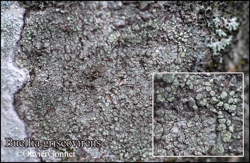
Courtesy Danièle et Olivier Gonnet - Source: https://www.afl-lichenologie.fr/Photos_AFL/Photos_AFL_B/Buellia_griseovirens.htm
France, sur écorce de frêne - session AFL 2010 - Hérault

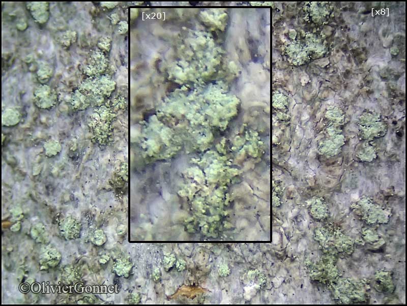
Courtesy Danièle et Olivier Gonnet - Source: https://www.afl-lichenologie.fr/Photos_AFL/Photos_AFL_B/Buellia_griseovirens.htm
France, Foncine-le-Haut, alt. 1120 m - Jura
24/8/2016 -

Courtesy Danièle et Olivier Gonnet - Source: https://www.afl-lichenologie.fr/Photos_AFL/Photos_AFL_B/Buellia_griseovirens.htm
France, Foncine-le-Haut, alt. 1120 m - Jura
24/8/2016 -

Courtesy Danièle et Olivier Gonnet - Source: https://www.afl-lichenologie.fr/Photos_AFL/Photos_AFL_B/Buellia_griseovirens.htm
France, Sotta - Corse
7/10/2015

Courtesy Danièle et Olivier Gonnet - Source: https://www.afl-lichenologie.fr/Photos_AFL/Photos_AFL_B/Buellia_griseovirens.htm
France, Sotta - Corse
7/10/2015

Courtesy Danièle et Olivier Gonnet - Source: https://www.afl-lichenologie.fr/Photos_AFL/Photos_AFL_B/Buellia_griseovirens.htm
France, Sotta - Corse
7/10/2015

Courtesy Danièle et Olivier Gonnet - Source: https://www.afl-lichenologie.fr/Photos_AFL/Photos_AFL_B/Buellia_griseovirens.htm
France, Sotta - Corse
7/10/2015

Courtesy Danièle et Olivier Gonnet - Source: https://www.afl-lichenologie.fr/Photos_AFL/Photos_AFL_B/Buellia_griseovirens.htm
France, Sotta - Corse
7/10/2015

Jacques Haine - Source: http://www.lichensmaritimes.org/index.php?task=fiche&lichen=491&lang=en
France, Ardennes

Jacques Haine - Source: http://www.lichensmaritimes.org/index.php?task=fiche&lichen=491&lang=en
France, Ardennes

Jacques Haine - Source: http://www.lichensmaritimes.org/index.php?task=fiche&lichen=491&lang=en
France, Ardennes
Wolfgang von Brackel - CC BY-4.0
Germany, Bavaria, Rodach
Wolfgang von Brackel - CC BY-4.0
Germany, Bavaria, Kempten
Felix Schumm - CC BY-SA 4.0
[VZ1661], Bohemoslovacia. Slovacia, Carpathi montes, Tatra Minor,
Predajná, in valle rivi Jesenský potok loco Kyslá dicto, 650 m. Ad
corticem Alni incanae. Leg. A. Vezda, 26.9.1979. EX A. VEZDA: LICHENES
SELECTI EXSICCATI NR. 1661.

Felix Schumm - CC BY-SA 4.0
[VZ1661], Bohemoslovacia. Slovacia, Carpathi montes, Tatra Minor,
Predajná, in valle rivi Jesenský potok loco Kyslá dicto, 650 m. Ad
corticem Alni incanae. Leg. A. Vezda, 26.9.1979. EX A. VEZDA: LICHENES
SELECTI EXSICCATI NR. 1661.
Growth form: Crustose
Substrata: bark
Photobiont: green algae other than Trentepohlia
Reproductive strategy: mainly asexual, by soredia, or soredia-like structures (e.g. blastidia)
Most common in areas with a humid-warm climate (e.g. most of Tyrrenian Italy)
Commonnes-rarity: (info)
Alpine belt: absent
Subalpine belt: absent
Montane belt: rather rare
Dry submediterranean belt: rather common
Humid submediterranean belt: common
Padanian area: extremely rare
pH of the substrata:
| 1 | 2 | 3 | 4 | 5 |
Solar irradiation:
| 1 | 2 | 3 | 4 | 5 |
Aridity:
| 1 | 2 | 3 | 4 | 5 |
Eutrophication:
| 1 | 2 | 3 | 4 | 5 |
Poleotolerance:
| 0 | 1 | 2 | 3 |
Altitudinal distribution:
| 1 | 2 | 3 | 4 | 5 | 6 |
Rarity
absent
extremely rare
very rare
rare
rather rare
rather common
common
very common
extremely common
Loading data...
Occurrence data
Predictive map
Current prediction (1981-2010)Future prediction (2071-2100) SSP 1-2.6Future prediction (2071-2100) SSP 5-8.5Predictive maps according to Francesconi et al. 2025
E. Pittao CC BY-SA 4.0
TSB TSB 9334
Andres Saag; Owner: University of Tartu
originally as Buellia griseovirens
E. Pittao; Owner: Department of Life Sciences, University of Trieste
Herbarium: TSB (TSB 21999)
20.10.2009
Leif Stridvall - Source: http://www.stridvall.se/la/galleries.php (Courtesy: Anita Stridvall)
Felix Schumm – CC BY-SA 4.0
[2329], Germany, Baden-Württemberg, Schwarzwald, im Spitalwald bei Herrenberg, TK 7419. Leg. et det. V. Wirth 08.05.1976
Felix Schumm – CC BY-SA 4.0
[2329], Germany, Baden-Württemberg, Schwarzwald, im Spitalwald bei Herrenberg, TK 7419. Leg. et det. V. Wirth 08.05.1976
Felix Schumm – CC BY-SA 4.0
[2329], Germany, Baden-Württemberg, Schwarzwald, im Spitalwald bei Herrenberg, TK 7419. Leg. et det. V. Wirth 08.05.1976
Felix Schumm – CC BY-SA 4.0
[2804], Germany, Baden-Württemberg, Im Tannbachtal westlich von Schwäbisch Gmünd an Laubholz, TK 7224/ leg. F. Schumm, Tobies, Payerl 24.03.1980, det F.Schumm
Felix Schumm – CC BY-SA 4.0
[2804], Germany, Baden-Württemberg, Im Tannbachtal westlich von Schwäbisch Gmünd an Laubholz, TK 7224/ leg. F. Schumm, Tobies, Payerl 24.03.1980, det F.Schumm
Felix Schumm – CC BY-SA 4.0
[2804], Germany, Baden-Württemberg, Im Tannbachtal westlich von Schwäbisch Gmünd an Laubholz, TK 7224/ leg. F. Schumm, Tobies, Payerl 24.03.1980, det F.Schumm
Felix Schumm – CC BY-SA 4.0
[2804], Germany, Baden-Württemberg, Im Tannbachtal westlich von Schwäbisch Gmünd an Laubholz, TK 7224/ leg. F. Schumm, Tobies, Payerl 24.03.1980, det F.Schumm
Felix Schumm – CC BY-SA 4.0
[2804], Germany, Baden-Württemberg, Im Tannbachtal westlich von Schwäbisch Gmünd an Laubholz, TK 7224/ leg. F. Schumm, Tobies, Payerl 24.03.1980, det F.Schumm
Felix Schumm – CC BY-SA 4.0
[4040], Germany, Baden-Württemberg, Kreis Göppingen, Marbachtal zwischen Börtlingen und Birenbach, an Fraxinus im Laubwald, ca. 360 m, TK 7223. Leg. et det. F. Schumm 18.04.1993.
Felix Schumm – CC BY-SA 4.0
[4040], Germany, Baden-Württemberg, Kreis Göppingen, Marbachtal zwischen Börtlingen und Birenbach, an Fraxinus im Laubwald, ca. 360 m, TK 7223. Leg. et det. F. Schumm 18.04.1993.
Felix Schumm – CC BY-SA 4.0
[4216], Germany, Baden-Württemberg, Kreis Schwäbisch Gmünd, im Beutenbachtal bei der Beutenmühle ca. 3 km südöstlich von Lorch, ca 310 m, an Fraxinus, TK 7224. Leg. et det. F. Schumm 29.05.1995

Felix Schumm – CC BY-SA 4.0
[4216], Germany, Baden-Württemberg, Kreis Schwäbisch Gmünd, im Beutenbachtal bei der Beutenmühle ca. 3 km südöstlich von Lorch, ca 310 m, an Fraxinus, TK 7224. Leg. et det. F. Schumm 29.05.1995

Felix Schumm – CC BY-SA 4.0
[4426], Germany, Baden-Württemberg, Rems-Murr-Kreis, Schorndorf, Eichenbachhang mit Viehweide, sonnige warme Streuobstwiesen, ca. 340 m, an Obstbäumen, TK 7223. Leg. et det. F. Schumm 25.03.1990
Felix Schumm – CC BY-SA 4.0
[4426], Germany, Baden-Württemberg, Rems-Murr-Kreis, Schorndorf, Eichenbachhang mit Viehweide, sonnige warme Streuobstwiesen, ca. 340 m, an Obstbäumen, TK 7223. Leg. et det. F. Schumm 25.03.1990
Felix Schumm – CC BY-SA 4.0
[6981], Germany, Baden-Württemberg, Kreis Göppingen, Marbachtal bei Zell-Börtlingen. An Eschen in Bachnähe, luftfeucht, lichtoffen, ca. 350 m, TK 7223. Leg. F. Schumm & U. Schwarz 24.04.2000, det. F. Schumm 03.05.2000.

Felix Schumm – CC BY-SA 4.0
[6981], Germany, Baden-Württemberg, Kreis Göppingen, Marbachtal bei Zell-Börtlingen. An Eschen in Bachnähe, luftfeucht, lichtoffen, ca. 350 m, TK 7223. Leg. F. Schumm & U. Schwarz 24.04.2000, det. F. Schumm 03.05.2000.
Felix Schumm – CC BY-SA 4.0
[12553], Germany, Baden-Württemberg, Kreis Göppingen, zwischen Wangen und Unterberken, Sulztrieblesweg beim Parkplatz Rotkreuz, an Eiche in Waldlichtung, 48°45.012'N, 9°34.837'E, 470 m, TK 7223. Leg. et det. F. Schumm 16.07.2007.
Felix Schumm – CC BY-SA 4.0
[12553], Germany, Baden-Württemberg, Kreis Göppingen, zwischen Wangen und Unterberken, Sulztrieblesweg beim Parkplatz Rotkreuz, an Eiche in Waldlichtung, 48°45.012'N, 9°34.837'E, 470 m, TK 7223. Leg. et det. F. Schumm 16.07.2007.

Felix Schumm – CC BY-SA 4.0
[14880], Germany, Baden-Württemberg, Schwäbische Alb, Kreis Göppingen, 3,5 km südlich von Donzdorf, im Längental südl. von Kuchalb, 48,65364° N, 9,81812° E, 665 m, auf Buche, TJ 7324. Leg. et det. F. Schumm 20.04.2009
Felix Schumm – CC BY-SA 4.0
[14880], Germany, Baden-Württemberg, Schwäbische Alb, Kreis Göppingen, 3,5 km südlich von Donzdorf, im Längental südl. von Kuchalb, 48,65364° N, 9,81812° E, 665 m, auf Buche, TJ 7324. Leg. et det. F. Schumm 20.04.2009

Felix Schumm – CC BY-SA 4.0
16641], Germany, Rheinland-Pfalz, Naturpark Pfälzer Wald, Wachenheimer Tal zwischen Oppauer Haus und Wachenheim, ca. 250 m. Leg. V. John 02.09.2010 (Blam Exkursion).
Felix Schumm – CC BY-SA 4.0
16641], Germany, Rheinland-Pfalz, Naturpark Pfälzer Wald, Wachenheimer Tal zwischen Oppauer Haus und Wachenheim, ca. 250 m. Leg. V. John 02.09.2010 (Blam Exkursion).
Felix Schumm – CC BY-SA 4.0
16641], Germany, Rheinland-Pfalz, Naturpark Pfälzer Wald, Wachenheimer Tal zwischen Oppauer Haus und Wachenheim, ca. 250 m. Leg. V. John 02.09.2010 (Blam Exkursion).
Felix Schumm – CC BY-SA 4.0
[19316], Germany, Baden-Württemberg, Kreis Göppiungen, Waldgebiet zwischen Oberberken und Adelberg, 48.77822° N, 9.57512° E, 507 m, auf Rinde eines Laubbaumes. Leg. et det. F. Schumm, 05.04.2015
Felix Schumm – CC BY-SA 4.0
[19316], Germany, Baden-Württemberg, Kreis Göppiungen, Waldgebiet zwischen Oberberken und Adelberg, 48.77822° N, 9.57512° E, 507 m, auf Rinde eines Laubbaumes. Leg. et det. F. Schumm, 05.04.2015
Felix Schumm – CC BY-SA 4.0
[19316], Germany, Baden-Württemberg, Kreis Göppiungen, Waldgebiet zwischen Oberberken und Adelberg, 48.77822° N, 9.57512° E, 507 m, auf Rinde eines Laubbaumes. Leg. et det. F. Schumm, 05.04.2015
Felix Schumm – CC BY-SA 4.0
[19316], Germany, Baden-Württemberg, Kreis Göppiungen, Waldgebiet zwischen Oberberken und Adelberg, 48.77822° N, 9.57512° E, 507 m, auf Rinde eines Laubbaumes. Leg. et det. F. Schumm, 05.04.2015

Felix Schumm – CC BY-SA 4.0
[19316], Germany, Baden-Württemberg, Kreis Göppiungen, Waldgebiet zwischen Oberberken und Adelberg, 48.77822° N, 9.57512° E, 507 m, auf Rinde eines Laubbaumes. Leg. et det. F. Schumm, 05.04.2015

Felix Schumm – CC BY-SA 4.0
[19316], Germany, Baden-Württemberg, Kreis Göppiungen, Waldgebiet zwischen Oberberken und Adelberg, 48.77822° N, 9.57512° E, 507 m, auf Rinde eines Laubbaumes. Leg. et det. F. Schumm, 05.04.2015

Felix Schumm – CC BY-SA 4.0
[19316], Germany, Baden-Württemberg, Kreis Göppiungen, Waldgebiet zwischen Oberberken und Adelberg, 48.77822° N, 9.57512° E, 507 m, auf Rinde eines Laubbaumes. Leg. et det. F. Schumm, 05.04.2015
Felix Schumm – CC BY-SA 4.0
[19316], Germany, Baden-Württemberg, Kreis Göppiungen, Waldgebiet zwischen Oberberken und Adelberg, 48.77822° N, 9.57512° E, 507 m, auf Rinde eines Laubbaumes. Leg. et det. F. Schumm, 05.04.2015

Felix Schumm – CC BY-SA 4.0
[19316], Germany, Baden-Württemberg, Kreis Göppiungen, Waldgebiet zwischen Oberberken und Adelberg, 48.77822° N, 9.57512° E, 507 m, auf Rinde eines Laubbaumes. Leg. et det. F. Schumm, 05.04.2015
Felix Schumm – CC BY-SA 4.0
[19619], Germany, Baden-Württemberg, Kreis Göppingen, am Parkplatz nahe der Zachersmühle im Heiligenwald, auf Laubbaum, 48.75277° N, 9.61983° E, 364 m. Leg. et det. F. Schumm, 07.02.2017.
Felix Schumm – CC BY-SA 4.0
[19619], Germany, Baden-Württemberg, Kreis Göppingen, am Parkplatz nahe der Zachersmühle im Heiligenwald, auf Laubbaum, 48.75277° N, 9.61983° E, 364 m. Leg. et det. F. Schumm, 07.02.2017.
Felix Schumm – CC BY-SA 4.0
[19619], Germany, Baden-Württemberg, Kreis Göppingen, am Parkplatz nahe der Zachersmühle im Heiligenwald, auf Laubbaum, 48.75277° N, 9.61983° E, 364 m. Leg. et det. F. Schumm, 07.02.2017.
Felix Schumm – CC BY-SA 4.0
[19619], Germany, Baden-Württemberg, Kreis Göppingen, am Parkplatz nahe der Zachersmühle im Heiligenwald, auf Laubbaum, 48.75277° N, 9.61983° E, 364 m. Leg. et det. F. Schumm, 07.02.2017.

Felix Schumm – CC BY-SA 4.0
[19619], Germany, Baden-Württemberg, Kreis Göppingen, am Parkplatz nahe der Zachersmühle im Heiligenwald, auf Laubbaum, 48.75277° N, 9.61983° E, 364 m. Leg. et det. F. Schumm, 07.02.2017.
Felix Schumm – CC BY-SA 4.0
[19619], Germany, Baden-Württemberg, Kreis Göppingen, am Parkplatz nahe der Zachersmühle im Heiligenwald, auf Laubbaum, 48.75277° N, 9.61983° E, 364 m. Leg. et det. F. Schumm, 07.02.2017.

Felix Schumm – CC BY-SA 4.0
[19619], Germany, Baden-Württemberg, Kreis Göppingen, am Parkplatz nahe der Zachersmühle im Heiligenwald, auf Laubbaum, 48.75277° N, 9.61983° E, 364 m. Leg. et det. F. Schumm, 07.02.2017.

Pier Luigi Nimis CC BY-SA 4.0
TSB 41700
Pier Luigi Nimis CC BY-SA 4.0
TSB 38816
Pier Luigi Nimis CC BY-SA 4.0
TSB 38817

Pier Luigi Nimis - CC BY-SA 4.0
TSB 42097

P.L. Nimis; Owner: Department of Life Sciences, University of Trieste
Herbarium: TSB (9344)
2001/11/22
Walter Obermayer CC BY-SA 4.0 - Source: Lichens of Noricum - http://lichens-of-noricum.uni-graz.at/
Austria
Hafellner 69227
Courtesy Danièle et Olivier Gonnet - Source: https://www.afl-lichenologie.fr/Photos_AFL/Photos_AFL_B/Buellia_griseovirens.htm
France, sur écorce de frêne - session AFL 2010 - Hérault
Courtesy Danièle et Olivier Gonnet - Source: https://www.afl-lichenologie.fr/Photos_AFL/Photos_AFL_B/Buellia_griseovirens.htm
France, Foncine-le-Haut, alt. 1120 m - Jura
24/8/2016 -
Courtesy Danièle et Olivier Gonnet - Source: https://www.afl-lichenologie.fr/Photos_AFL/Photos_AFL_B/Buellia_griseovirens.htm
France, Foncine-le-Haut, alt. 1120 m - Jura
24/8/2016 -
Courtesy Danièle et Olivier Gonnet - Source: https://www.afl-lichenologie.fr/Photos_AFL/Photos_AFL_B/Buellia_griseovirens.htm
France, Sotta - Corse
7/10/2015

Courtesy Danièle et Olivier Gonnet - Source: https://www.afl-lichenologie.fr/Photos_AFL/Photos_AFL_B/Buellia_griseovirens.htm
France, Sotta - Corse
7/10/2015
Courtesy Danièle et Olivier Gonnet - Source: https://www.afl-lichenologie.fr/Photos_AFL/Photos_AFL_B/Buellia_griseovirens.htm
France, Sotta - Corse
7/10/2015
Courtesy Danièle et Olivier Gonnet - Source: https://www.afl-lichenologie.fr/Photos_AFL/Photos_AFL_B/Buellia_griseovirens.htm
France, Sotta - Corse
7/10/2015
Courtesy Danièle et Olivier Gonnet - Source: https://www.afl-lichenologie.fr/Photos_AFL/Photos_AFL_B/Buellia_griseovirens.htm
France, Sotta - Corse
7/10/2015
Jacques Haine - Source: http://www.lichensmaritimes.org/index.php?task=fiche&lichen=491&lang=en
France, Ardennes

Jacques Haine - Source: http://www.lichensmaritimes.org/index.php?task=fiche&lichen=491&lang=en
France, Ardennes
Jacques Haine - Source: http://www.lichensmaritimes.org/index.php?task=fiche&lichen=491&lang=en
France, Ardennes
Wolfgang von Brackel - CC BY-4.0
Germany, Bavaria, Rodach
Wolfgang von Brackel - CC BY-4.0
Germany, Bavaria, Kempten

Felix Schumm - CC BY-SA 4.0
[VZ1661], Bohemoslovacia. Slovacia, Carpathi montes, Tatra Minor, Predajná, in valle rivi Jesenský potok loco Kyslá dicto, 650 m. Ad corticem Alni incanae. Leg. A. Vezda, 26.9.1979. EX A. VEZDA: LICHENES SELECTI EXSICCATI NR. 1661.