
Chrysothrix candelaris (L.) J.R. Laundon
Lichenologist, 13: 110, 1981. Basionym: Byssus candelaris L. - Sp. Pl., 2: 1169, 1753.
Synonyms: Chaenotheca trichialis f. candelaris Dalla Torre & Sarnth.; Crocynia flava auct.; Crocynia flavissima B. de Lesd.; Lepra candelaris auct. p.p.; Lepra citrina auct. ital. p.p.; Lepra flava auct. ital. p.p.; Lepraria candelaris (L.) Fr.; Lepraria citrina auct. p.p.
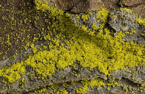
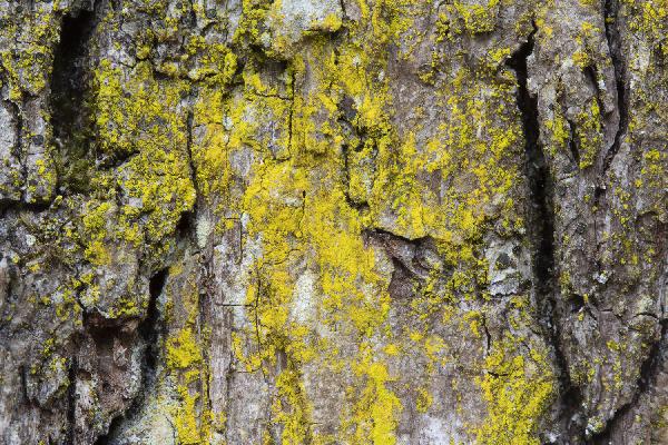
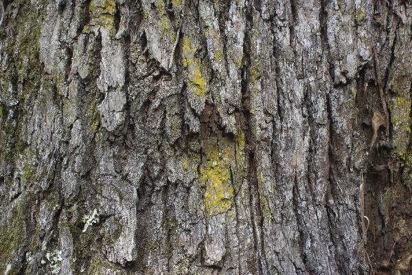
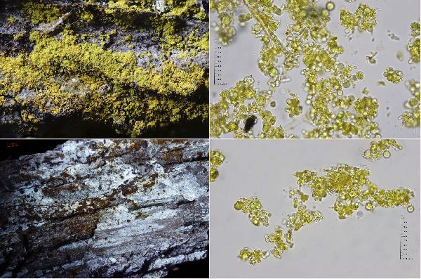
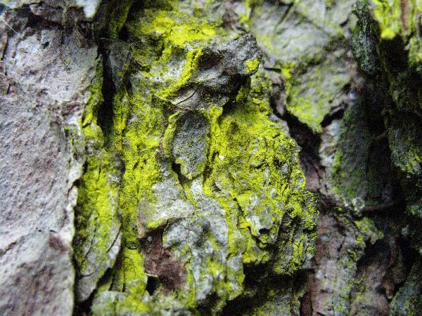
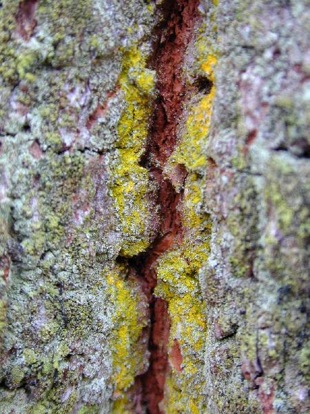
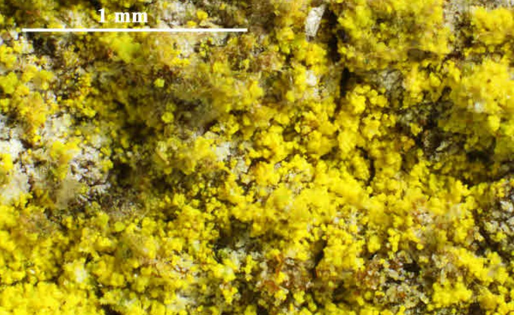
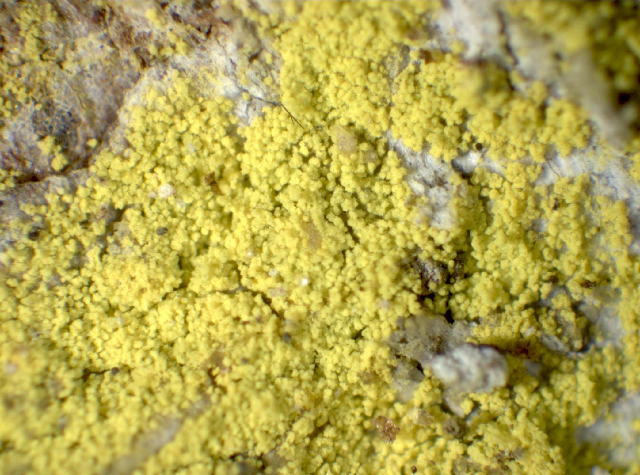
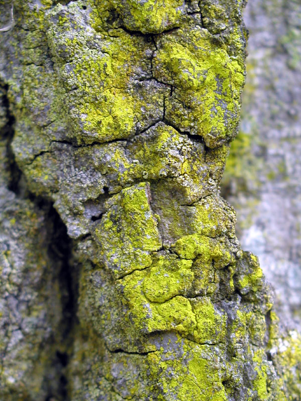
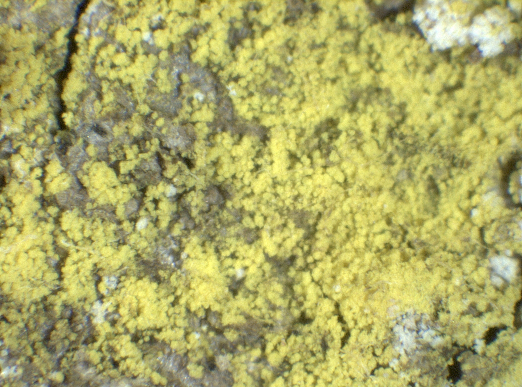
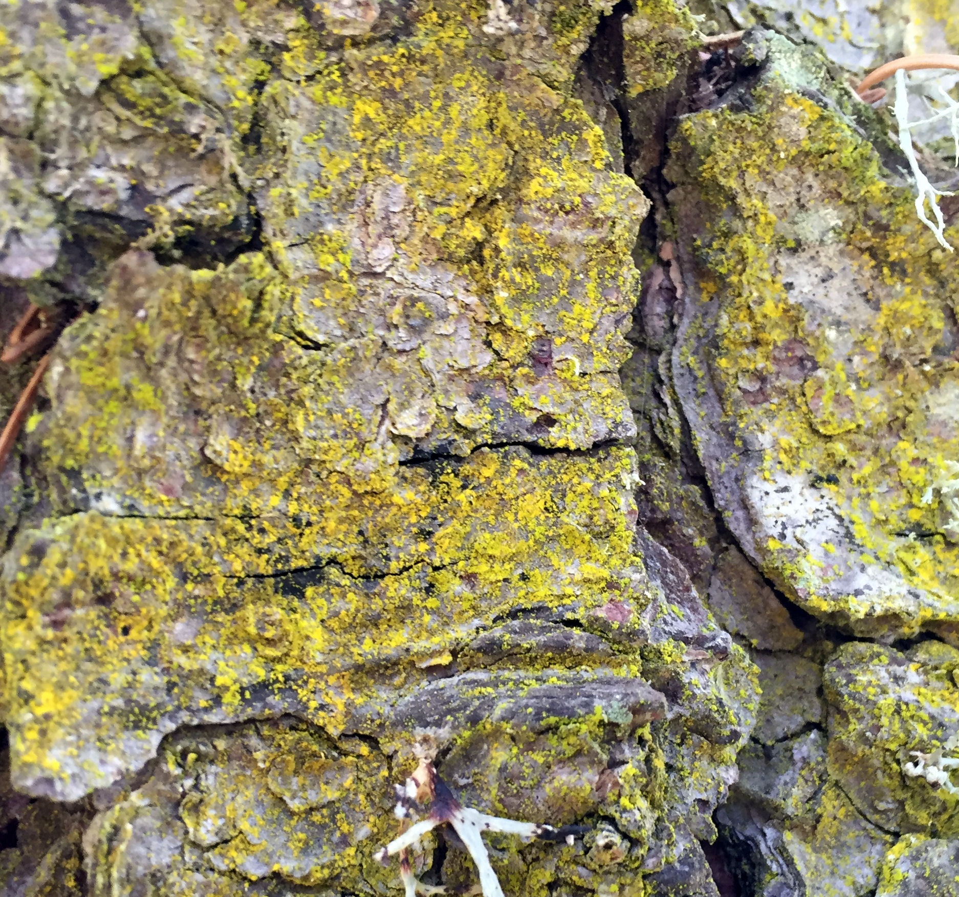
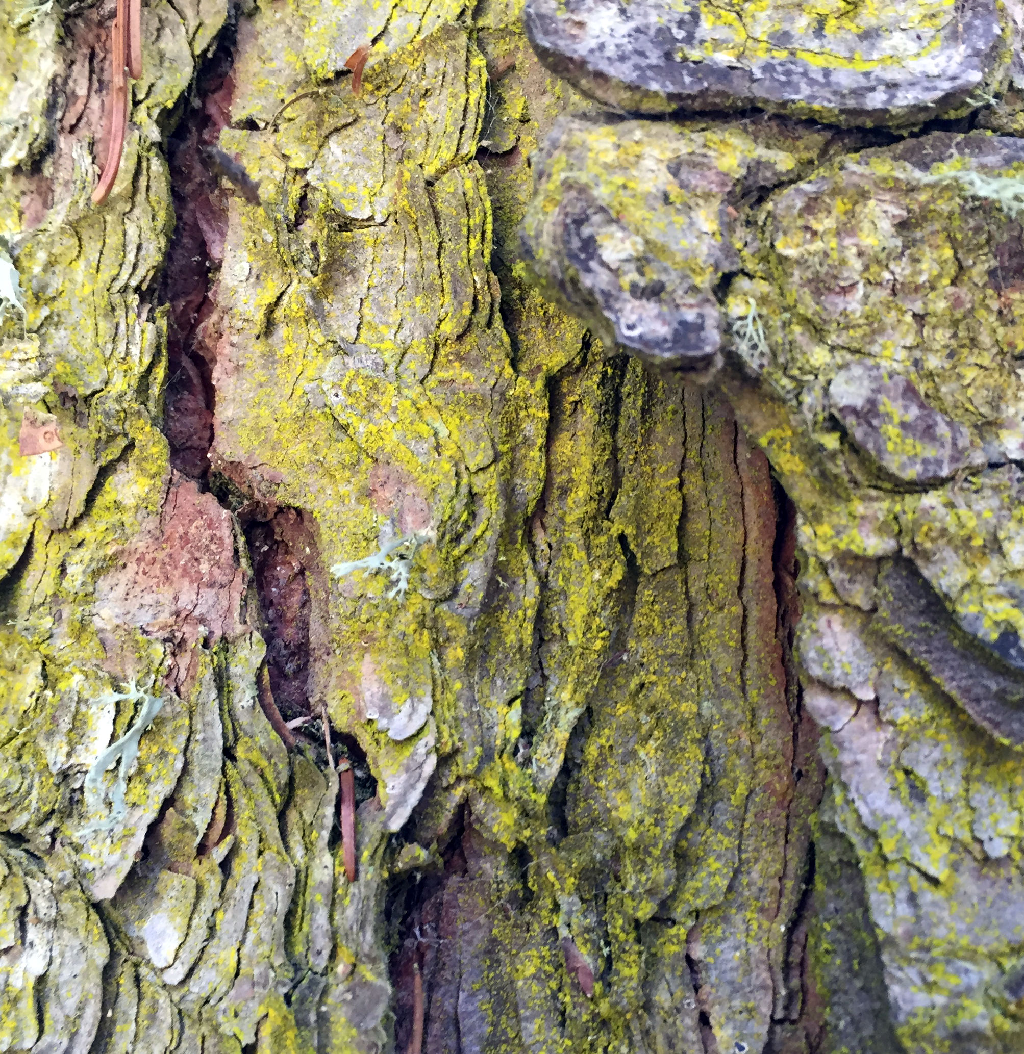
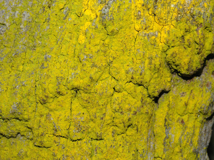
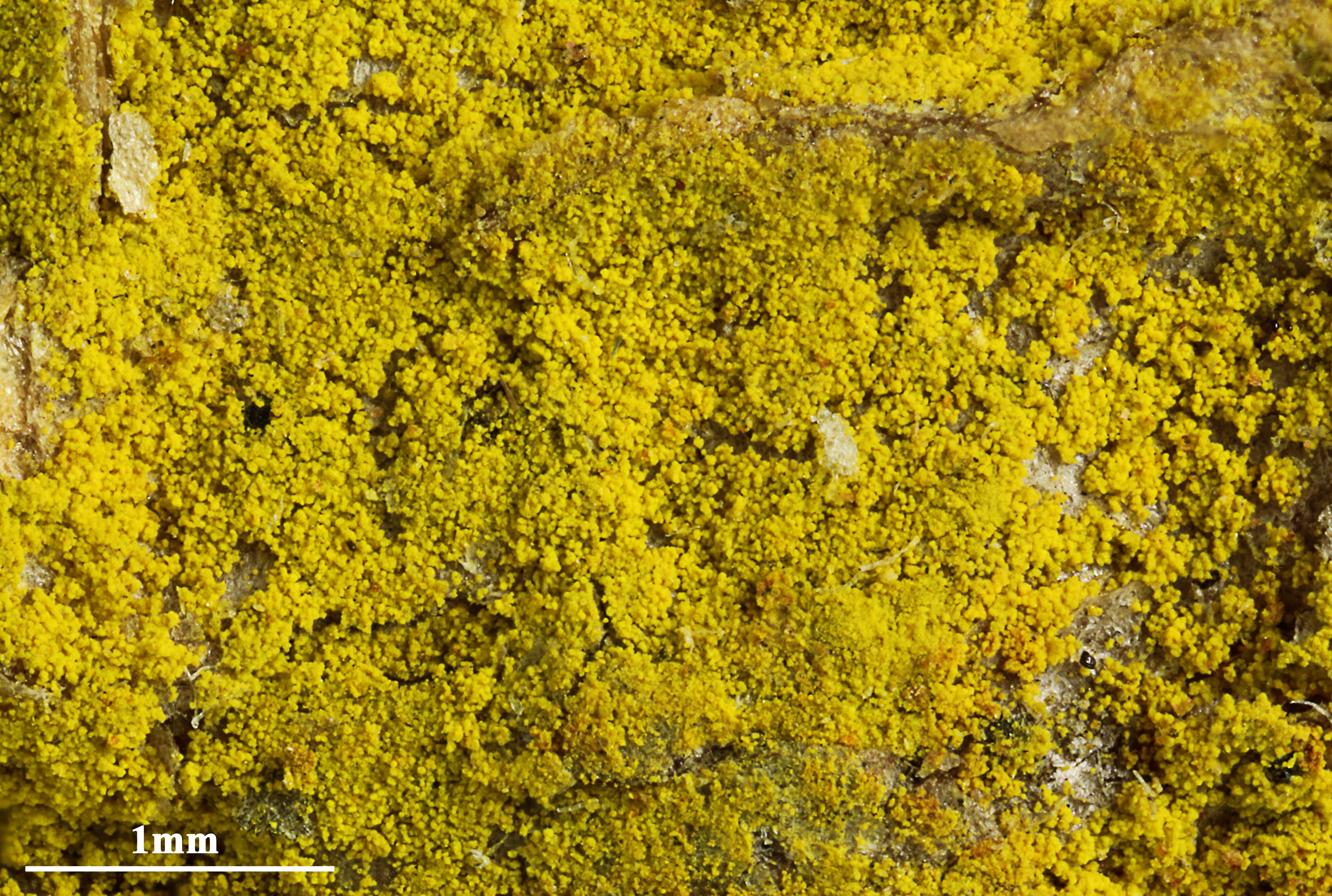
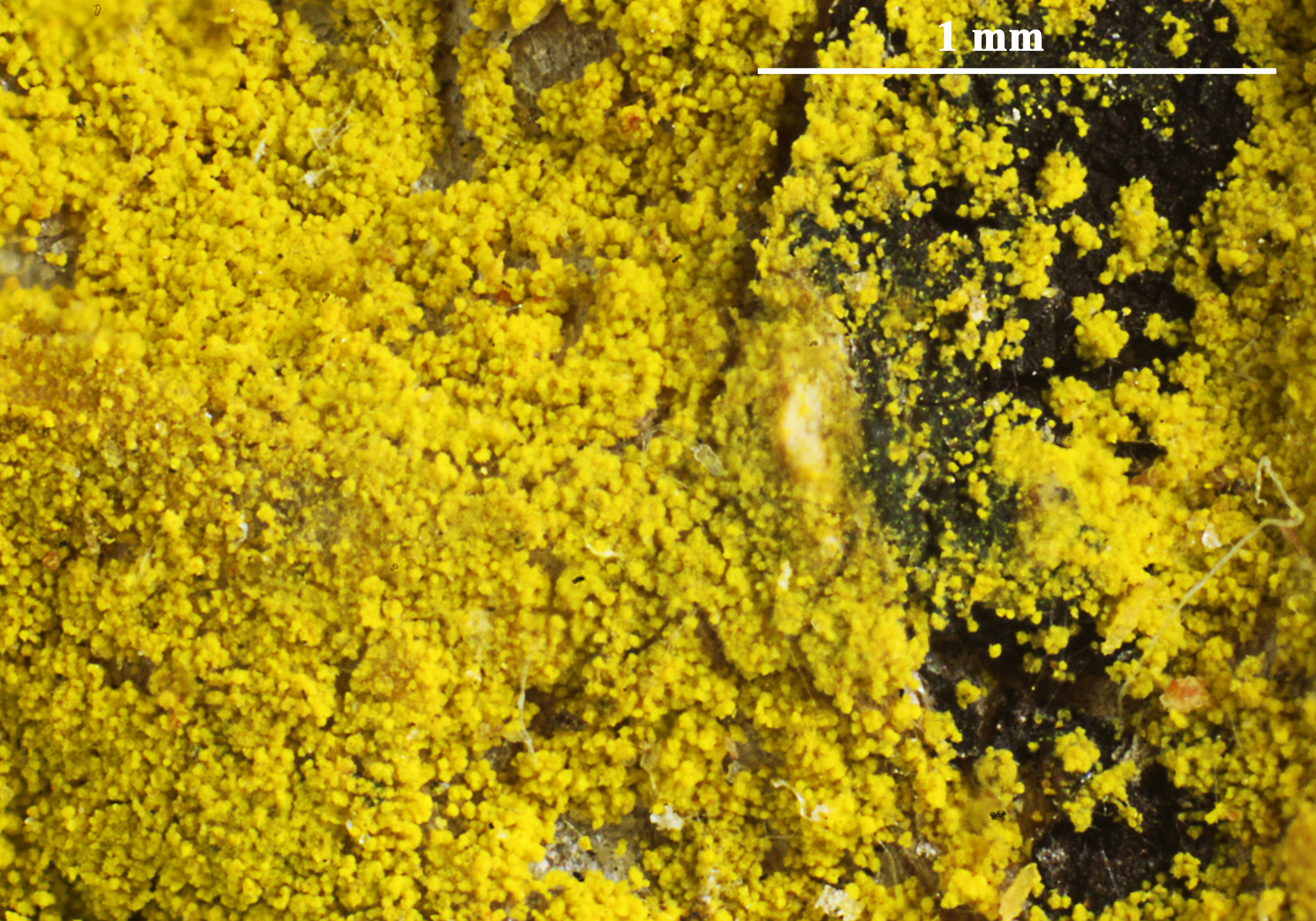
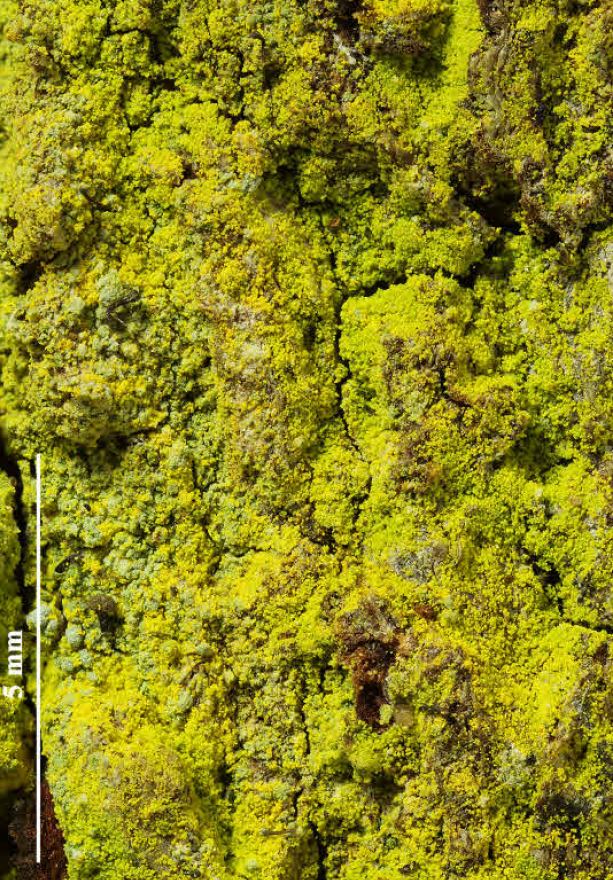
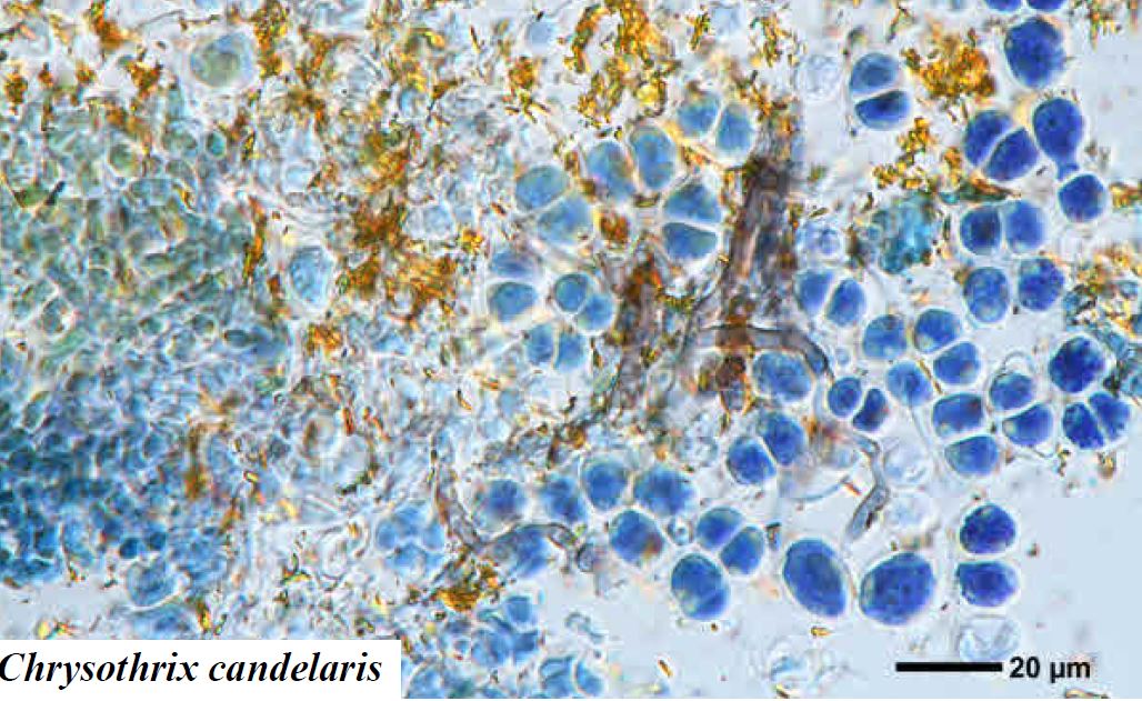
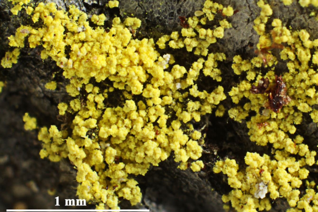
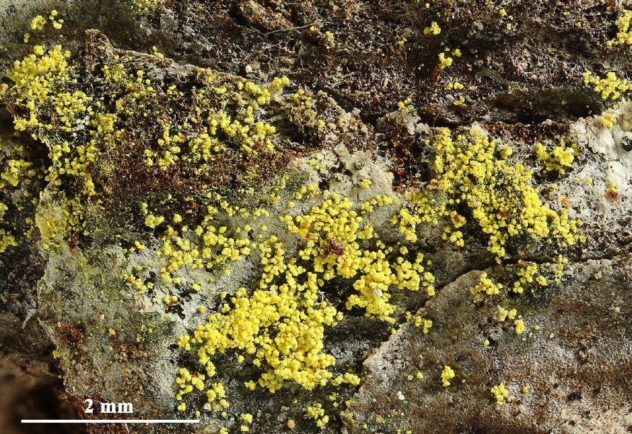
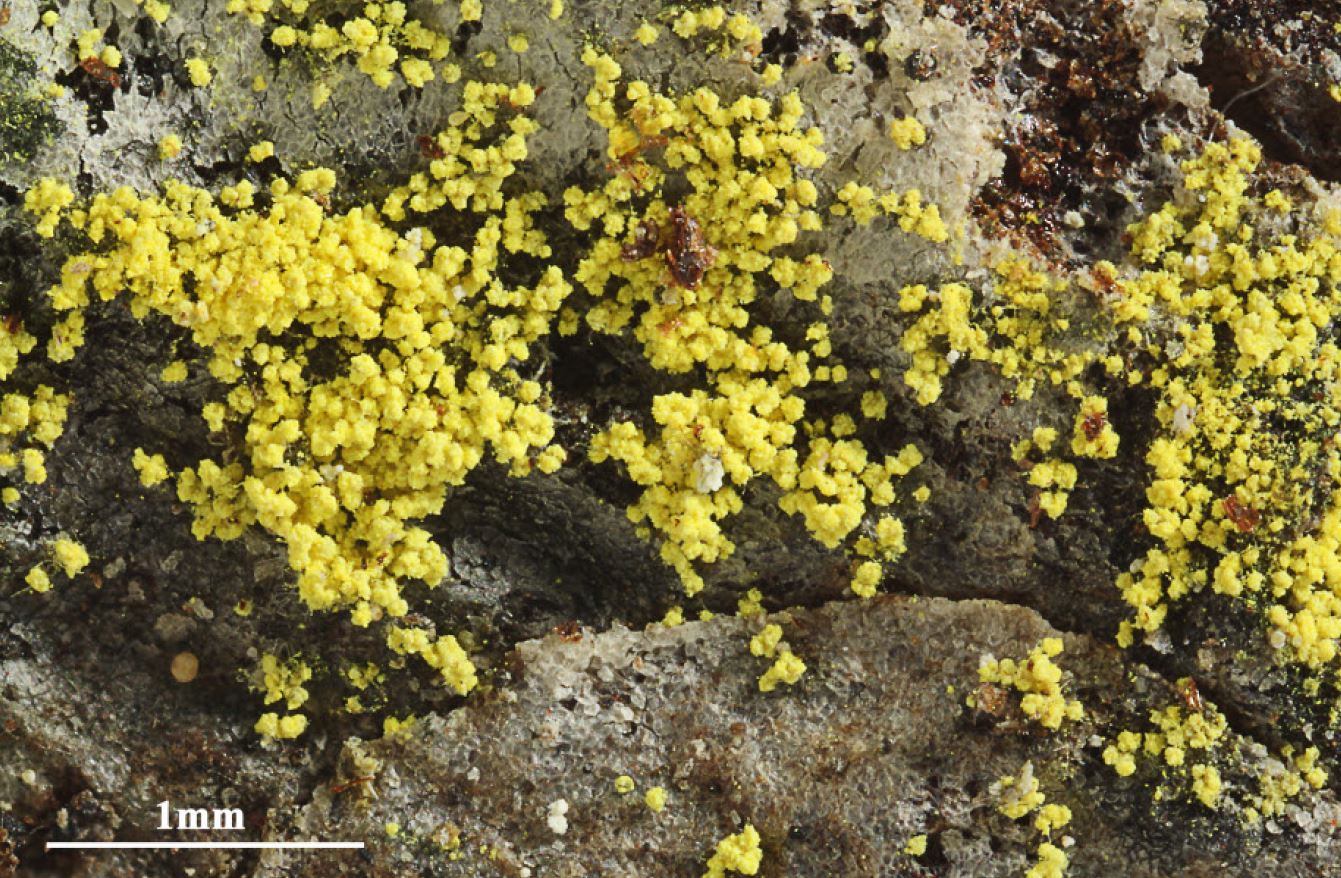
Description: Thallus leprose, woolly-textured, poorly delimited, usually thin (less than 0.4 mm thick), sometimes of scattered granules, but usually continuous to rarely cracked, covering rather large surfaces, bright lemon- yellow, golden yellow, greenish yellow in very shaded situations, sometimes tinged orange on old bark, consisting of a mass of fine soredia-like granules measuring (10-)25-50(-100) µm; medulla usually not evident, in thick thalli sometimes indistinctly present, yellow. Apothecia very rare, biatorine, 0.2-0.5 mm across, round or angular, with a flat to slightly convex, pale orange-yellow, often yellow-pruinose disc, and a thin, ecorticate, soon excluded proper margin. Proper exciple poorly developed, up to 10 µm thick; epithecium colourless, up to 18 µm high; hymenium colourless, up to 50 µm high; paraphysoids 1-1.5 µm thick, richly branched and anastomosing, intertwined in epithecium; hypothecium colourless, poorly developed. Asci 8-spored, clavate, with a K/I+ blue layer between the two walls which is thicker in the apical part, becoming more diffuse downwardly. Ascospores (1-)3-septate, constricted in the middle septum, hyaline, 9-14 x c. 3 µm. Photobiont chlorococcoid. Spot tests: K- or K+ faintly orange, C-, KC- or KC+ faintly orange, P- or P+ faintly orange, UV- or UV+ dull orange. Chemistry: calycin or pinastric acid, rarely both.
Growth form: Leprose
Substrata: bark
Photobiont: green algae other than Trentepohlia
Reproductive strategy: mainly asexual, by soredia, or soredia-like structures (e.g. blastidia)
In underhangs rarely wetted by rain
Commonnes-rarity: (info)
Alpine belt: absent
Subalpine belt: extremely rare
Montane belt: rather common
Dry submediterranean belt: rather rare
Humid submediterranean belt: common
Padanian area: extremely rare
pH of the substrata:
1 2 3 4 5

Solar irradiation:
1 2 3 4 5
Aridity:
1 2 3 4 5
Eutrophication:
1 2 3 4 5
Poleotolerance:
0 1 2 3
Altitudinal distribution:
1 2 3 4 5 6
Rarity
absent
extremely rare
very rare
rare
rather rare
rather common
common
very common
extremely common
Loading data...
Occurrence data
Predictive map
 Current prediction (1981-2010)
 Future prediction (2071-2100) SSP 1-2.6
 Future prediction (2071-2100) SSP 5-8.5Predictive maps according to Francesconi et al. 2025
Felix Schumm – CC BY-SA 4.0
[19452], Germany, Baden-Württemberg, Kreis Ludwigsburg, im Krummbachtal zwischen Büsnau und Gerlingen (Kücherain), 48.76951° N, 9.05428° E, 428 m, im Laubwald an der Stammbasis von Quercus, TK: 7220/NW. Leg. F. Schumm, 22.05.2016.

P.L. Nimis; Owner: Department of Life Sciences, University of Trieste
Herbarium: TSB (26680)
2001/12/04

Andres Saag; Owner: University of Tartu

P.L.Nimis; Owner: Department of Life Sciences, University of Trieste
Herbarium: TSB (35165)
2008.03.03

P.L. Nimis; Owner: Department of Life Sciences, University of Trieste
Italy, Friuli Venezia Giulia, Udine, Bosco della Stua, Lago di Sauris, 1000m
09.09.2016

P.L. Nimis; Owner: Department of Life Sciences, University of Trieste
Italy, Friuli Venezia Giulia, Udine, Passo del Pura, ampezzo Carnico, 1400 m
09.09.2016

P.L. Nimis; Owner: Department of Life Sciences, University of Trieste
Italy, Friuli Venezia Giulia, Udine, Passo del Pura, Ampezzo Carnico, 1400 m
09.09.2016

P.L. Nimis; Owner: Department of Life Sciences, University of Trieste
Italy, Friuli Venezia Giulia, Udine, Passo del Pura, Ampezzo Carnico, 1400 m
09.09.2016

Leif Stridvall - Source: http://www.stridvall.se/la/galleries.php (Courtesy: Anita Stridvall)

Felix Schumm - CC BY-SA 4.0
[17172], Mexico, Baja California Sur, Sierra de la Laguna, E of Todos Santos, trail to Sierra de la Laguna, subtropical thorn forest bordering the Sonoran Desert to Oak forest, on bark of a deciduous tree. 24°32' N, 110°00' W. Leg. K. & A. Kalb & Th.Nash, 03.01.1991. KALB: LICHENES NEOTROPICI 498.

Felix Schumm – CC BY-SA 4.0
[19452], Germany, Baden-Württemberg, Kreis Ludwigsburg, im Krummbachtal zwischen Büsnau und Gerlingen (Kücherain), 48.76951° N, 9.05428° E, 428 m, im Laubwald an der Stammbasis von Quercus, TK: 7220/NW. Leg. F. Schumm, 22.05.2016.

Felix Schumm – CC BY-SA 4.0
[19452], Germany, Baden-Württemberg, Kreis Ludwigsburg, im Krummbachtal zwischen Büsnau und Gerlingen (Kücherain), 48.76951° N, 9.05428° E, 428 m, im Laubwald an der Stammbasis von Quercus, TK: 7220/NW. Leg. F. Schumm, 22.05.2016.

Felix Schumm – CC BY-SA 4.0
[19452], Germany, Baden-Württemberg, Kreis Ludwigsburg, im Krummbachtal zwischen Büsnau und Gerlingen (Kücherain), 48.76951° N, 9.05428° E, 428 m, im Laubwald an der Stammbasis von Quercus, TK: 7220/NW. Leg. F. Schumm, 22.05.2016.

Felix Schumm – CC BY-SA 4.0
[19452], Germany, Baden-Württemberg, Kreis Ludwigsburg, im Krummbachtal zwischen Büsnau und Gerlingen (Kücherain), 48.76951° N, 9.05428° E, 428 m, im Laubwald an der Stammbasis von Quercus, TK: 7220/NW. Leg. F. Schumm, 22.05.2016.

Felix Schumm – CC BY-SA 4.0
[19452], Germany, Baden-Württemberg, Kreis Ludwigsburg, im Krummbachtal zwischen Büsnau und Gerlingen (Kücherain), 48.76951° N, 9.05428° E, 428 m, im Laubwald an der Stammbasis von Quercus, TK: 7220/NW. Leg. F. Schumm, 22.05.2016.

Felix Schumm – CC BY-SA 4.0
[19452], Germany, Baden-Württemberg, Kreis Ludwigsburg, im Krummbachtal zwischen Büsnau und Gerlingen (Kücherain), 48.76951° N, 9.05428° E, 428 m, im Laubwald an der Stammbasis von Quercus, TK: 7220/NW. Leg. F. Schumm, 22.05.2016.

Felix Schumm - CC BY-SA 4.0
[9588], Germany, Baden-Württemberg, Kreis Schramberg, westliche Talseite im Schiltachtal, 3 km südlich Schramberg, auf Kiefernrinde, 550 m, TK: 7716/SW. Leg. V. Wirth & U. Schwarz 21.11.1992, det. V. Wirth 1992.

Felix Schumm - CC BY-SA 4.0
[9588], Germany, Baden-Württemberg, Kreis Schramberg, westliche Talseite im Schiltachtal, 3 km südlich Schramberg, auf Kiefernrinde, 550 m, TK: 7716/SW. Leg. V. Wirth & U. Schwarz 21.11.1992, det. V. Wirth 1992.

Felix Schumm - CC BY-SA 4.0
[9588], Germany, Baden-Württemberg, Kreis Schramberg, westliche Talseite im Schiltachtal, 3 km südlich Schramberg, auf Kiefernrinde, 550 m, TK: 7716/SW. Leg. V. Wirth & U. Schwarz 21.11.1992, det. V. Wirth 1992.

Pier Luigi Nimis - CC BY-SA 4.0
TSB 37232

Pier Luigi Nimis - CC BY-SA 4.0
TSB 37232

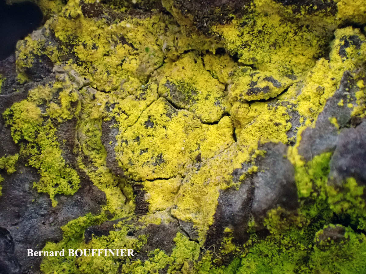
Bernard Bouffinier - Source: http://www.lichensmaritimes.org/index.php?task=fiche&lichen=361&lang=en
France, Pont Croix

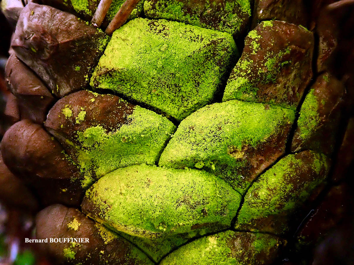
Bernard Bouffinier - Source: http://www.lichensmaritimes.org/index.php?task=fiche&lichen=361&lang=en
France, Telgruc-sur-mer

Bernard Bouffinier - Source: http://www.lichensmaritimes.org/index.php?task=fiche&lichen=361&lang=en
France, Crozon

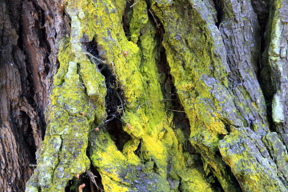
Alain Gerault - Source: http://www.lichensmaritimes.org/index.php?task=fiche&lichen=361&lang=en
France, Ria du Conquet

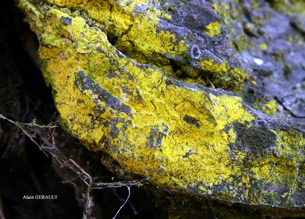
Alain Gerault - Source: http://www.lichensmaritimes.org/index.php?task=fiche&lichen=361&lang=en
France, Ria du Conquet

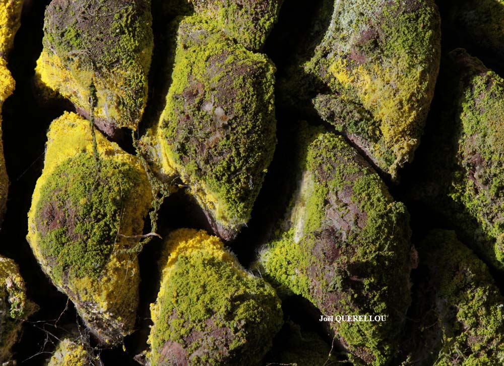
Joël Querellou - Source: http://www.lichensmaritimes.org/index.php?task=fiche&lichen=361&lang=en
France, Brest

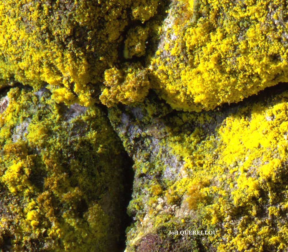
Joël Querellou - Source: http://www.lichensmaritimes.org/index.php?task=fiche&lichen=361&lang=en
France, Le Conquet

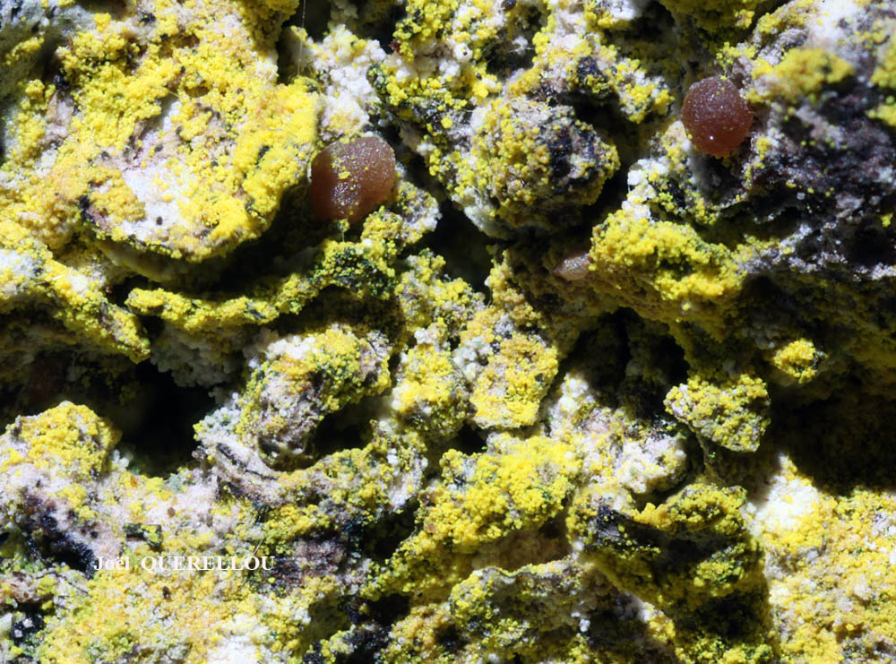
Joël Querellou - Source: http://www.lichensmaritimes.org/index.php?task=fiche&lichen=361&lang=en
France, Le Conquet

Joël Querellou - Source: http://www.lichensmaritimes.org/index.php?task=fiche&lichen=361&lang=en
France
Ulrich Kirschbaum CC BY-SA 4.0 - Source: https://www.thm.de/lse/ulrich-kirschbaum/flechtenbilder
Austria; Alps: Tirol.
Marta Gonzalez Garcia - Centro de Estudios Micologicos Asturianos
Spain, Jardín Botánico Atlántico (Gijón-Asturias), 17-X-2023, en corteza de Quercus robur, leg. & det. M. González.
Marta Gonzalez Garcia - Centro de Estudios Micologicos Asturianos
Spain, Jardín Botánico Atlántico (Gijón-Asturias), 17-X-2023, en corteza de Quercus robur, leg. & det. M. González.
Marta Gonzalez Garcia - Centro de Estudios Micologicos Asturianos
Spain, Jardín Botánico Atlántico (Gijón-Asturias), 17-X-2023, en corteza de Quercus robur, leg. & det. M. González.
Wolfgang von Brackel - CC BY-4.0
Germany, Bavaria, Berchtesgaden
Wolfgang von Brackel - CC BY-4.0
Germany, Bavaria, Grafenwöhr
Growth form: Leprose
Substrata: bark
Photobiont: green algae other than Trentepohlia
Reproductive strategy: mainly asexual, by soredia, or soredia-like structures (e.g. blastidia)
In underhangs rarely wetted by rain
Commonnes-rarity: (info)
Alpine belt: absent
Subalpine belt: extremely rare
Montane belt: rather common
Dry submediterranean belt: rather rare
Humid submediterranean belt: common
Padanian area: extremely rare
pH of the substrata:
| 1 | 2 | 3 | 4 | 5 |
Solar irradiation:
| 1 | 2 | 3 | 4 | 5 |
Aridity:
| 1 | 2 | 3 | 4 | 5 |
Eutrophication:
| 1 | 2 | 3 | 4 | 5 |
Poleotolerance:
| 0 | 1 | 2 | 3 |
Altitudinal distribution:
| 1 | 2 | 3 | 4 | 5 | 6 |
Rarity
absent
extremely rare
very rare
rare
rather rare
rather common
common
very common
extremely common
Loading data...
Occurrence data
Predictive map
Current prediction (1981-2010)Future prediction (2071-2100) SSP 1-2.6Future prediction (2071-2100) SSP 5-8.5Predictive maps according to Francesconi et al. 2025
Felix Schumm – CC BY-SA 4.0
[19452], Germany, Baden-Württemberg, Kreis Ludwigsburg, im Krummbachtal zwischen Büsnau und Gerlingen (Kücherain), 48.76951° N, 9.05428° E, 428 m, im Laubwald an der Stammbasis von Quercus, TK: 7220/NW. Leg. F. Schumm, 22.05.2016.
P.L. Nimis; Owner: Department of Life Sciences, University of Trieste
Herbarium: TSB (26680)
2001/12/04
Andres Saag; Owner: University of Tartu
P.L.Nimis; Owner: Department of Life Sciences, University of Trieste
Herbarium: TSB (35165)
2008.03.03
P.L. Nimis; Owner: Department of Life Sciences, University of Trieste
Italy, Friuli Venezia Giulia, Udine, Bosco della Stua, Lago di Sauris, 1000m
09.09.2016

P.L. Nimis; Owner: Department of Life Sciences, University of Trieste
Italy, Friuli Venezia Giulia, Udine, Passo del Pura, ampezzo Carnico, 1400 m
09.09.2016
P.L. Nimis; Owner: Department of Life Sciences, University of Trieste
Italy, Friuli Venezia Giulia, Udine, Passo del Pura, Ampezzo Carnico, 1400 m
09.09.2016

P.L. Nimis; Owner: Department of Life Sciences, University of Trieste
Italy, Friuli Venezia Giulia, Udine, Passo del Pura, Ampezzo Carnico, 1400 m
09.09.2016
Leif Stridvall - Source: http://www.stridvall.se/la/galleries.php (Courtesy: Anita Stridvall)
Felix Schumm - CC BY-SA 4.0
[17172], Mexico, Baja California Sur, Sierra de la Laguna, E of Todos Santos, trail to Sierra de la Laguna, subtropical thorn forest bordering the Sonoran Desert to Oak forest, on bark of a deciduous tree. 24°32' N, 110°00' W. Leg. K. & A. Kalb & Th.Nash, 03.01.1991. KALB: LICHENES NEOTROPICI 498.

Felix Schumm – CC BY-SA 4.0
[19452], Germany, Baden-Württemberg, Kreis Ludwigsburg, im Krummbachtal zwischen Büsnau und Gerlingen (Kücherain), 48.76951° N, 9.05428° E, 428 m, im Laubwald an der Stammbasis von Quercus, TK: 7220/NW. Leg. F. Schumm, 22.05.2016.
Felix Schumm - CC BY-SA 4.0
[17172], Mexico, Baja California Sur, Sierra de la Laguna, E of Todos Santos, trail to Sierra de la Laguna, subtropical thorn forest bordering the Sonoran Desert to Oak forest, on bark of a deciduous tree. 24°32' N, 110°00' W. Leg. K. & A. Kalb & Th.Nash, 03.01.1991. KALB: LICHENES NEOTROPICI 498.
Felix Schumm – CC BY-SA 4.0
[19452], Germany, Baden-Württemberg, Kreis Ludwigsburg, im Krummbachtal zwischen Büsnau und Gerlingen (Kücherain), 48.76951° N, 9.05428° E, 428 m, im Laubwald an der Stammbasis von Quercus, TK: 7220/NW. Leg. F. Schumm, 22.05.2016.

Felix Schumm – CC BY-SA 4.0
[19452], Germany, Baden-Württemberg, Kreis Ludwigsburg, im Krummbachtal zwischen Büsnau und Gerlingen (Kücherain), 48.76951° N, 9.05428° E, 428 m, im Laubwald an der Stammbasis von Quercus, TK: 7220/NW. Leg. F. Schumm, 22.05.2016.

Felix Schumm – CC BY-SA 4.0
[19452], Germany, Baden-Württemberg, Kreis Ludwigsburg, im Krummbachtal zwischen Büsnau und Gerlingen (Kücherain), 48.76951° N, 9.05428° E, 428 m, im Laubwald an der Stammbasis von Quercus, TK: 7220/NW. Leg. F. Schumm, 22.05.2016.

Felix Schumm – CC BY-SA 4.0
[19452], Germany, Baden-Württemberg, Kreis Ludwigsburg, im Krummbachtal zwischen Büsnau und Gerlingen (Kücherain), 48.76951° N, 9.05428° E, 428 m, im Laubwald an der Stammbasis von Quercus, TK: 7220/NW. Leg. F. Schumm, 22.05.2016.
Felix Schumm – CC BY-SA 4.0
[19452], Germany, Baden-Württemberg, Kreis Ludwigsburg, im Krummbachtal zwischen Büsnau und Gerlingen (Kücherain), 48.76951° N, 9.05428° E, 428 m, im Laubwald an der Stammbasis von Quercus, TK: 7220/NW. Leg. F. Schumm, 22.05.2016.

Felix Schumm – CC BY-SA 4.0
[19452], Germany, Baden-Württemberg, Kreis Ludwigsburg, im Krummbachtal zwischen Büsnau und Gerlingen (Kücherain), 48.76951° N, 9.05428° E, 428 m, im Laubwald an der Stammbasis von Quercus, TK: 7220/NW. Leg. F. Schumm, 22.05.2016.
Felix Schumm - CC BY-SA 4.0
[9588], Germany, Baden-Württemberg, Kreis Schramberg, westliche Talseite im Schiltachtal, 3 km südlich Schramberg, auf Kiefernrinde, 550 m, TK: 7716/SW. Leg. V. Wirth & U. Schwarz 21.11.1992, det. V. Wirth 1992.
Felix Schumm - CC BY-SA 4.0
[9588], Germany, Baden-Württemberg, Kreis Schramberg, westliche Talseite im Schiltachtal, 3 km südlich Schramberg, auf Kiefernrinde, 550 m, TK: 7716/SW. Leg. V. Wirth & U. Schwarz 21.11.1992, det. V. Wirth 1992.
Felix Schumm - CC BY-SA 4.0
[9588], Germany, Baden-Württemberg, Kreis Schramberg, westliche Talseite im Schiltachtal, 3 km südlich Schramberg, auf Kiefernrinde, 550 m, TK: 7716/SW. Leg. V. Wirth & U. Schwarz 21.11.1992, det. V. Wirth 1992.

Pier Luigi Nimis - CC BY-SA 4.0
TSB 37232

Pier Luigi Nimis - CC BY-SA 4.0
TSB 37232
Bernard Bouffinier - Source: http://www.lichensmaritimes.org/index.php?task=fiche&lichen=361&lang=en
France, Pont Croix
Bernard Bouffinier - Source: http://www.lichensmaritimes.org/index.php?task=fiche&lichen=361&lang=en
France, Telgruc-sur-mer

Bernard Bouffinier - Source: http://www.lichensmaritimes.org/index.php?task=fiche&lichen=361&lang=en
France, Crozon
Alain Gerault - Source: http://www.lichensmaritimes.org/index.php?task=fiche&lichen=361&lang=en
France, Ria du Conquet
Alain Gerault - Source: http://www.lichensmaritimes.org/index.php?task=fiche&lichen=361&lang=en
France, Ria du Conquet

Joël Querellou - Source: http://www.lichensmaritimes.org/index.php?task=fiche&lichen=361&lang=en
France, Brest
Joël Querellou - Source: http://www.lichensmaritimes.org/index.php?task=fiche&lichen=361&lang=en
France, Le Conquet
Joël Querellou - Source: http://www.lichensmaritimes.org/index.php?task=fiche&lichen=361&lang=en
France, Le Conquet
Joël Querellou - Source: http://www.lichensmaritimes.org/index.php?task=fiche&lichen=361&lang=en
France

Ulrich Kirschbaum CC BY-SA 4.0 - Source: https://www.thm.de/lse/ulrich-kirschbaum/flechtenbilder
Austria; Alps: Tirol.

Marta Gonzalez Garcia - Centro de Estudios Micologicos Asturianos
Spain, Jardín Botánico Atlántico (Gijón-Asturias), 17-X-2023, en corteza de Quercus robur, leg. & det. M. González.

Marta Gonzalez Garcia - Centro de Estudios Micologicos Asturianos
Spain, Jardín Botánico Atlántico (Gijón-Asturias), 17-X-2023, en corteza de Quercus robur, leg. & det. M. González.

Marta Gonzalez Garcia - Centro de Estudios Micologicos Asturianos
Spain, Jardín Botánico Atlántico (Gijón-Asturias), 17-X-2023, en corteza de Quercus robur, leg. & det. M. González.

Wolfgang von Brackel - CC BY-4.0
Germany, Bavaria, Berchtesgaden


