
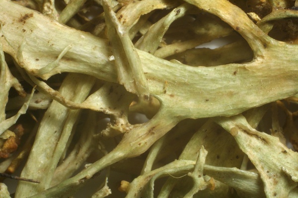
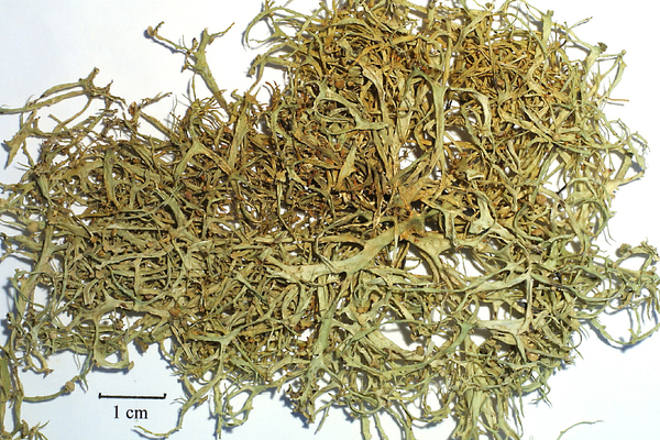
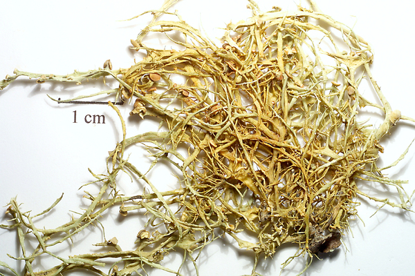
Ramalina implectens Nyl.
Bull. Soc. Linn. Normandie, sér. 2, 4: 116, 1870.
Synonyms:
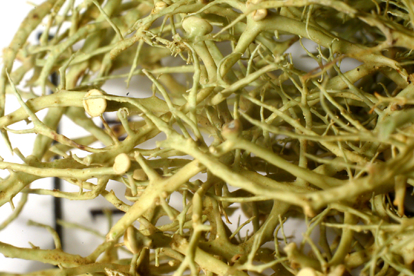
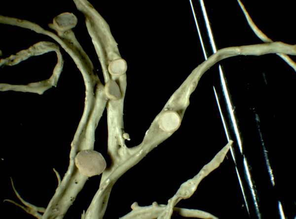
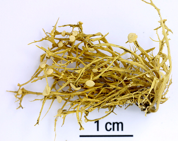
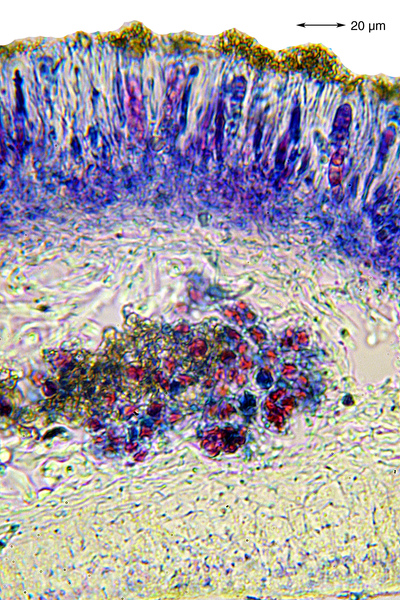
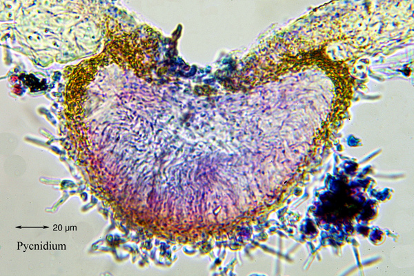
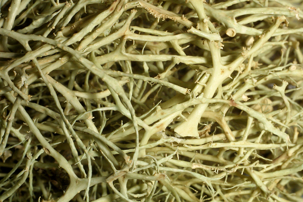
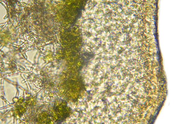
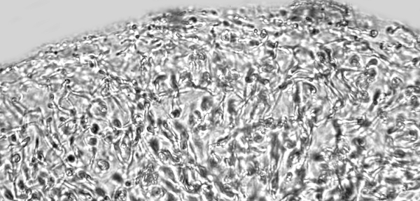
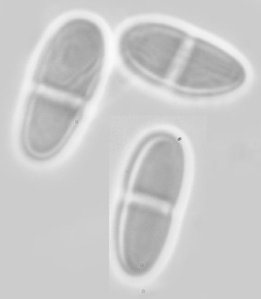
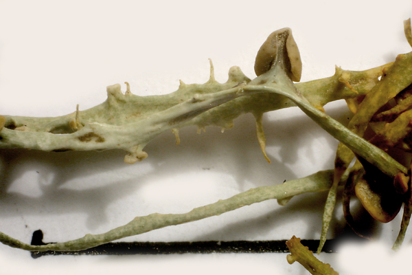
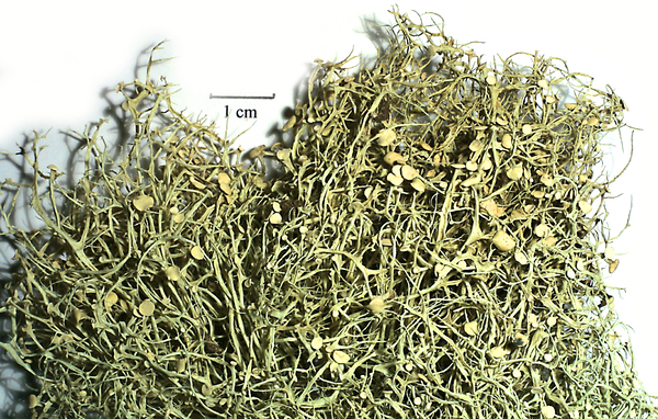
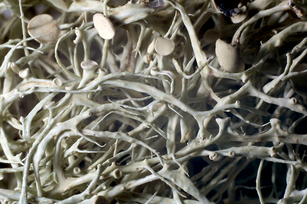
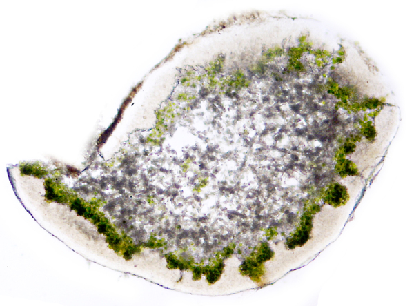
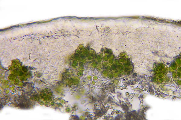
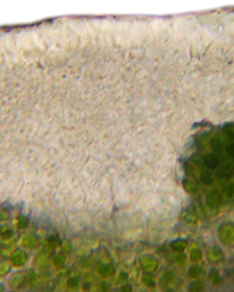
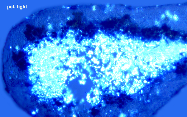
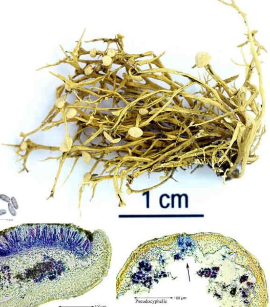
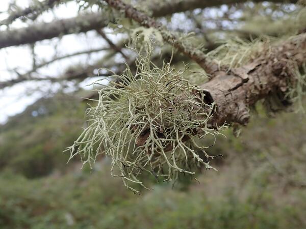
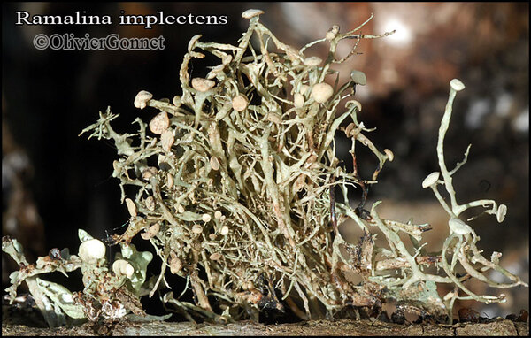
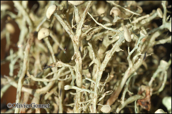
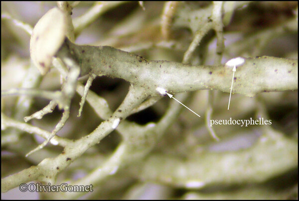
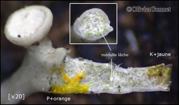
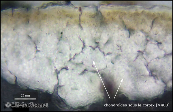
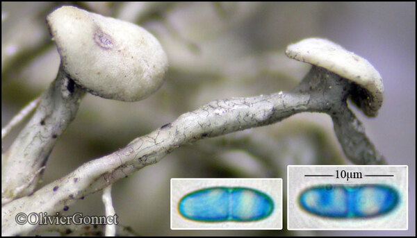
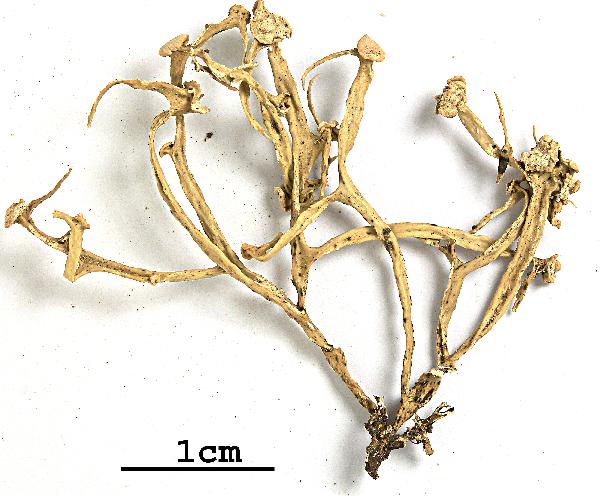
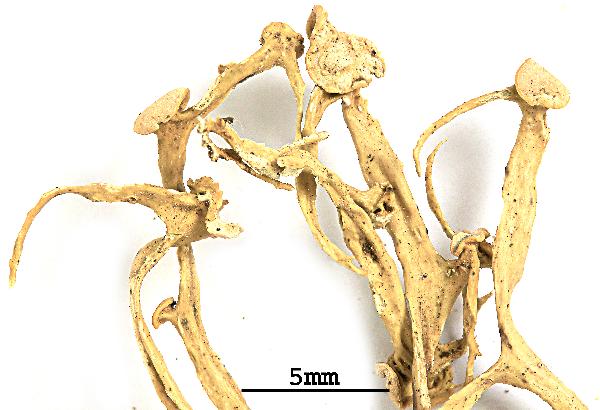
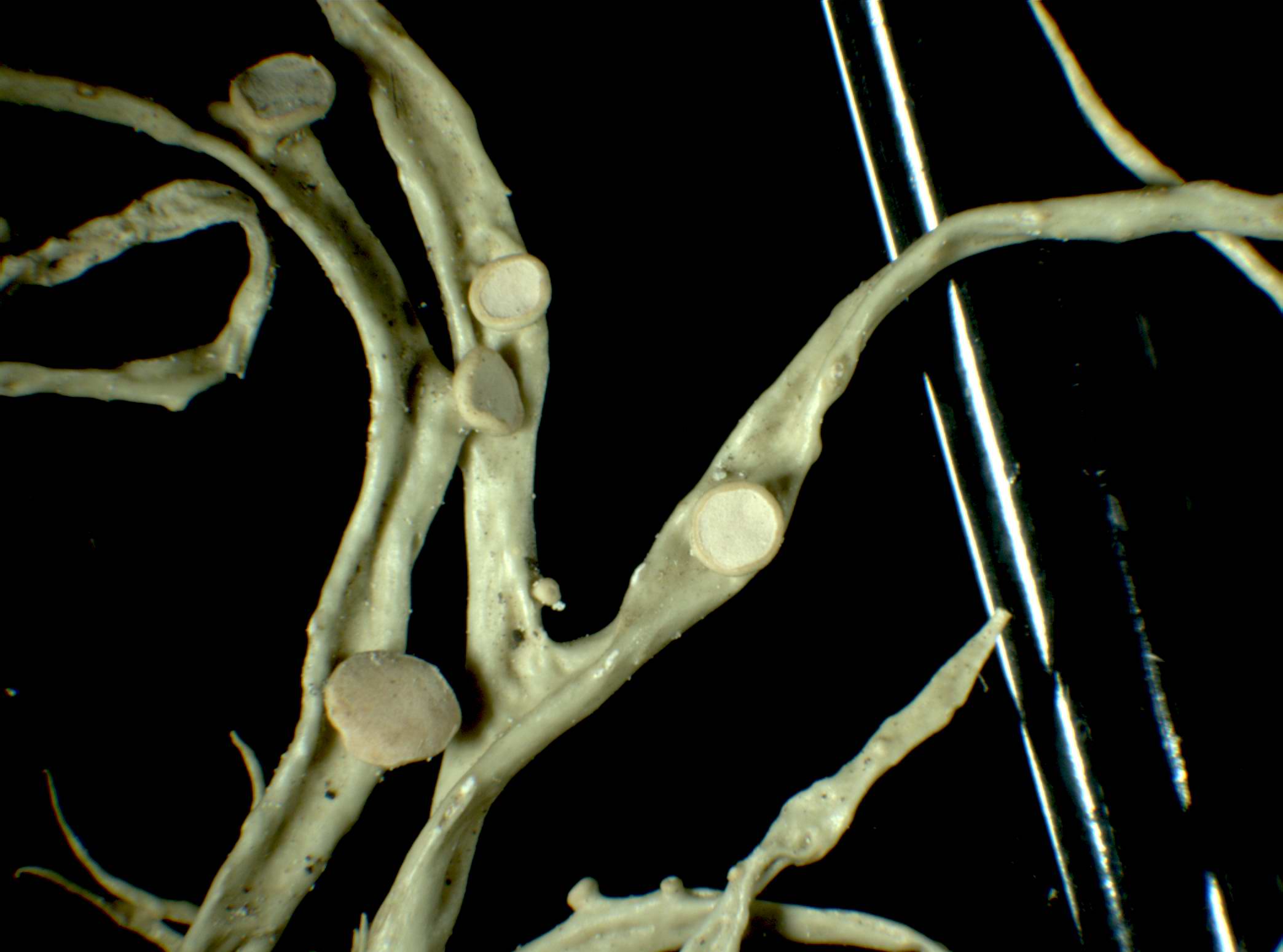
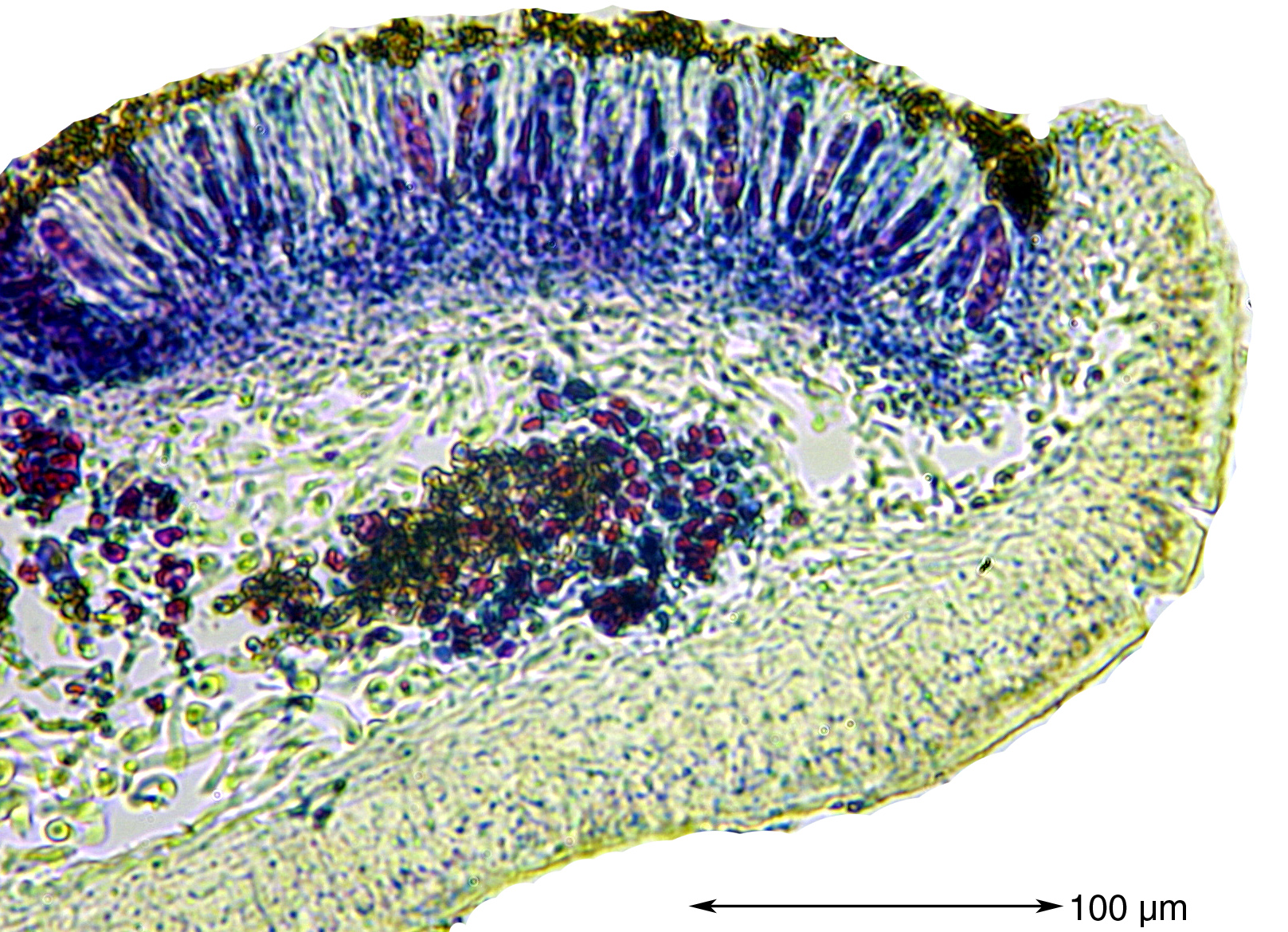
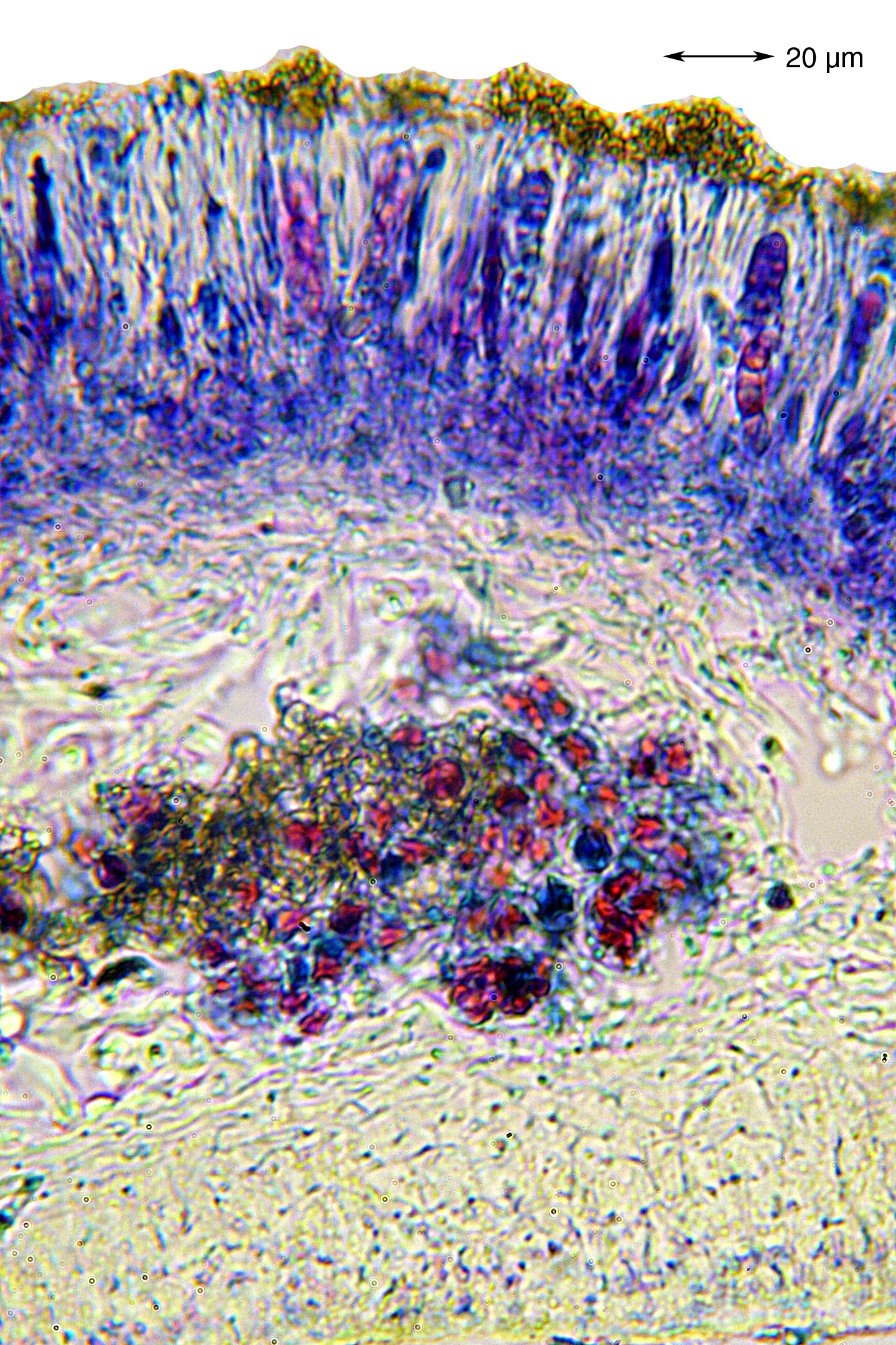
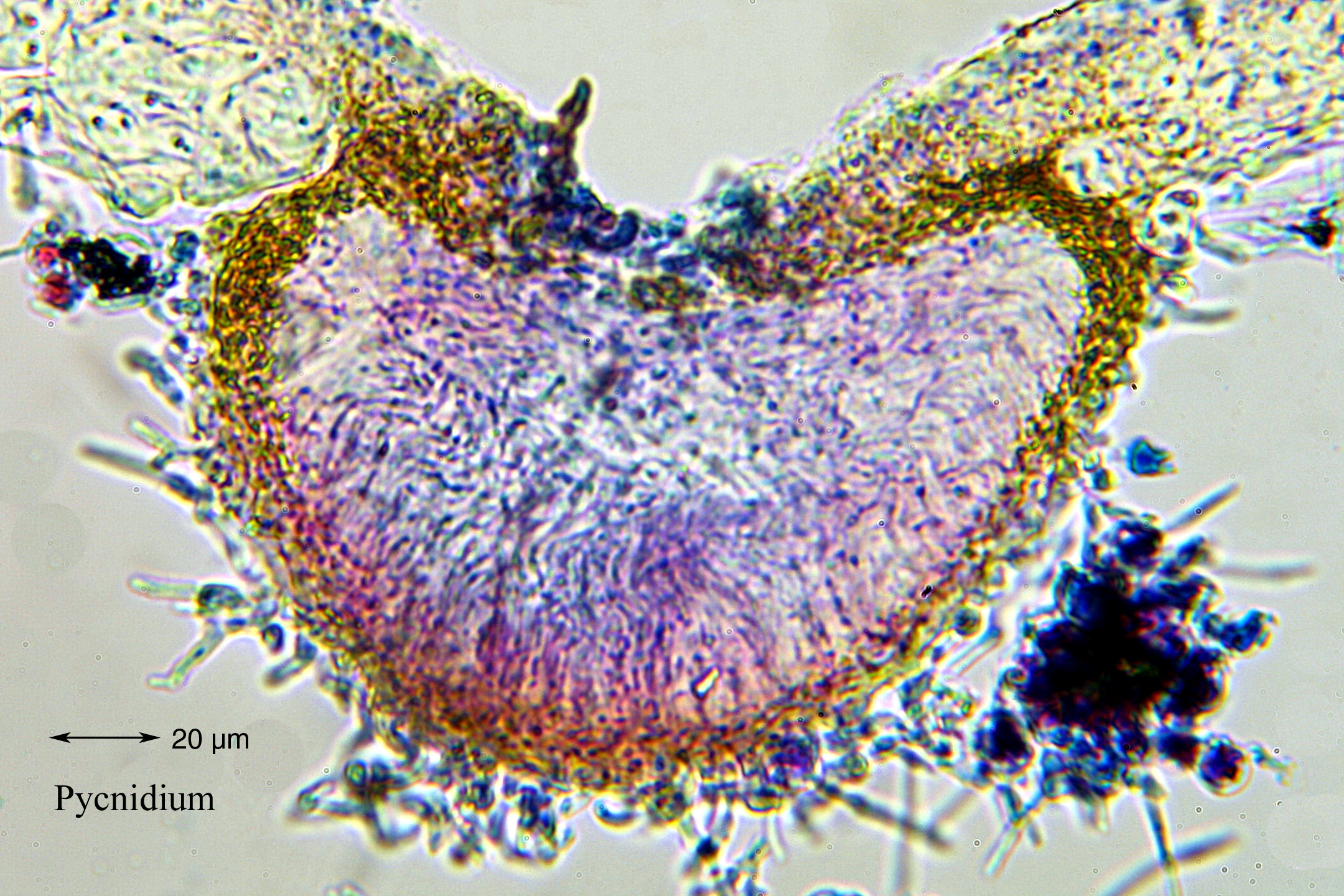
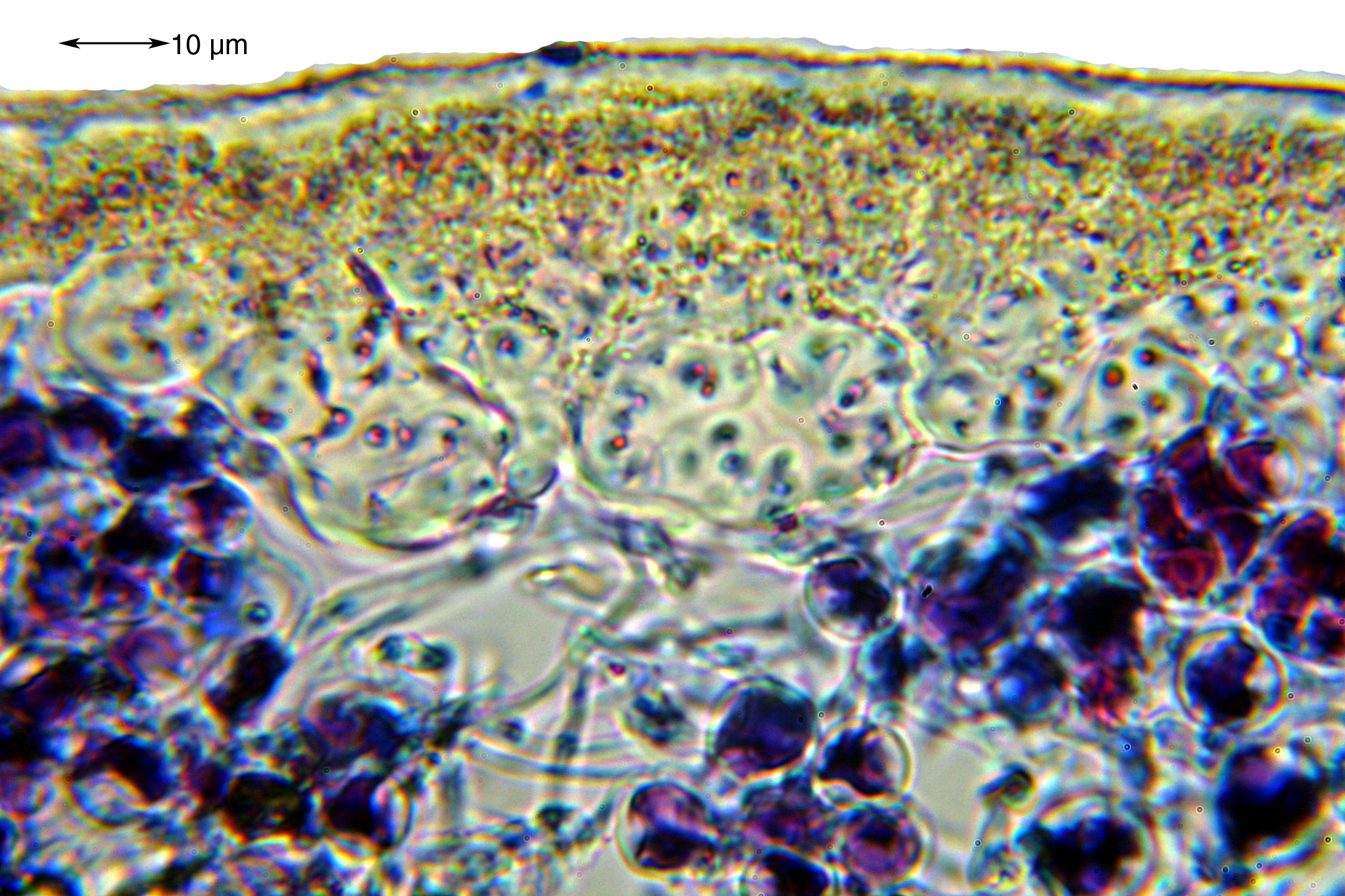
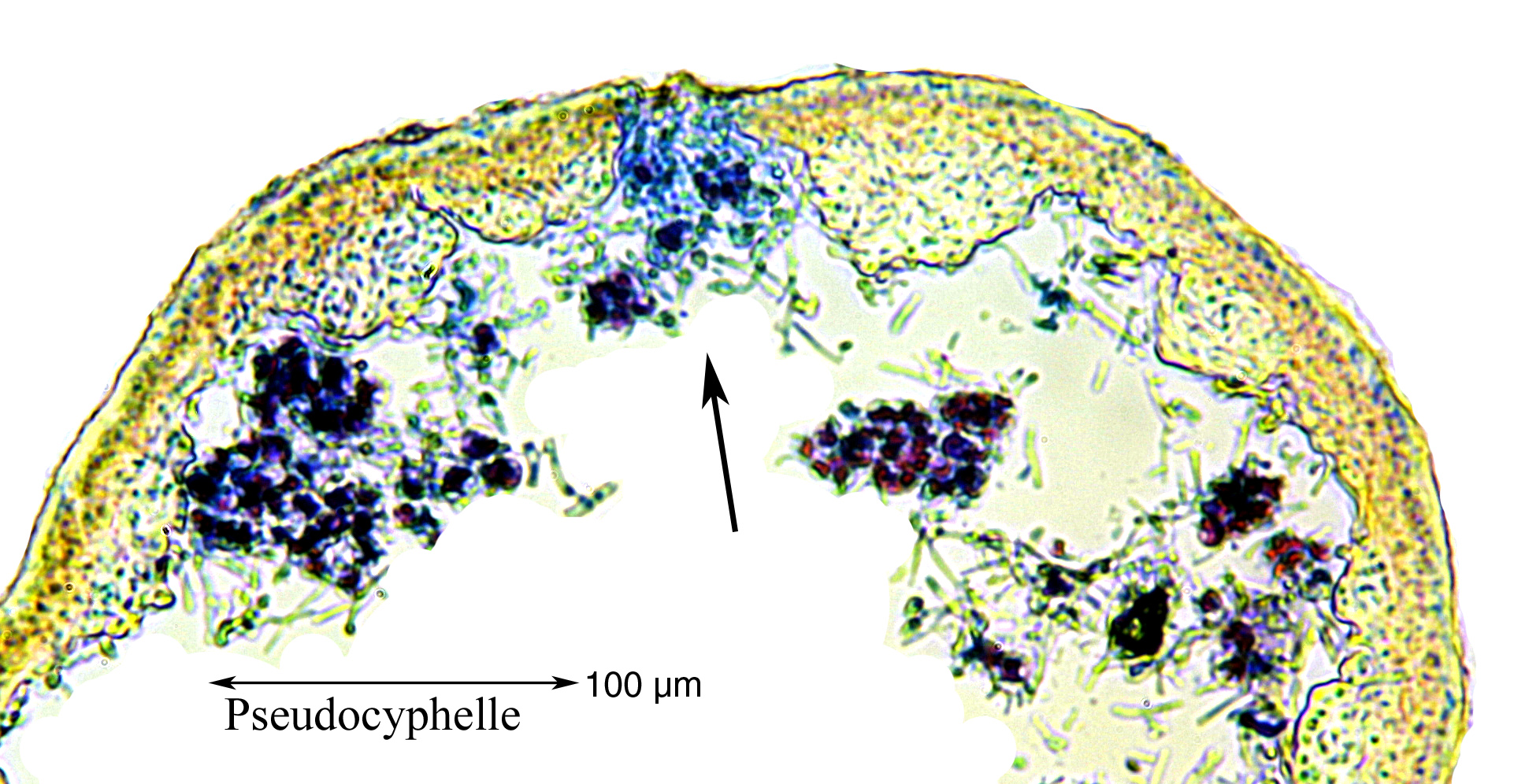
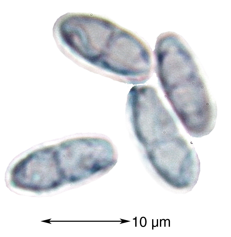
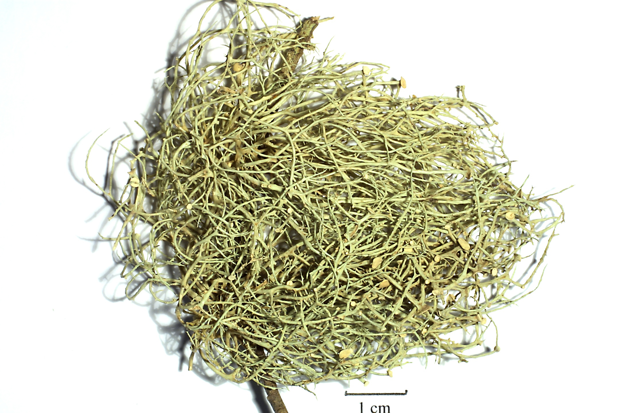
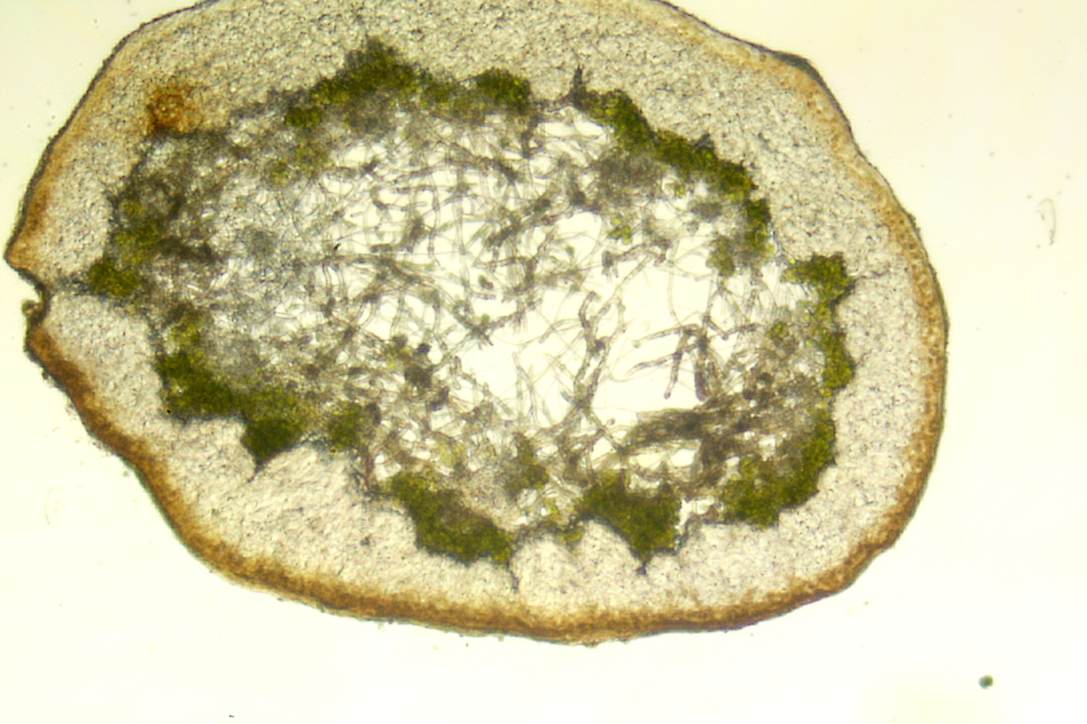
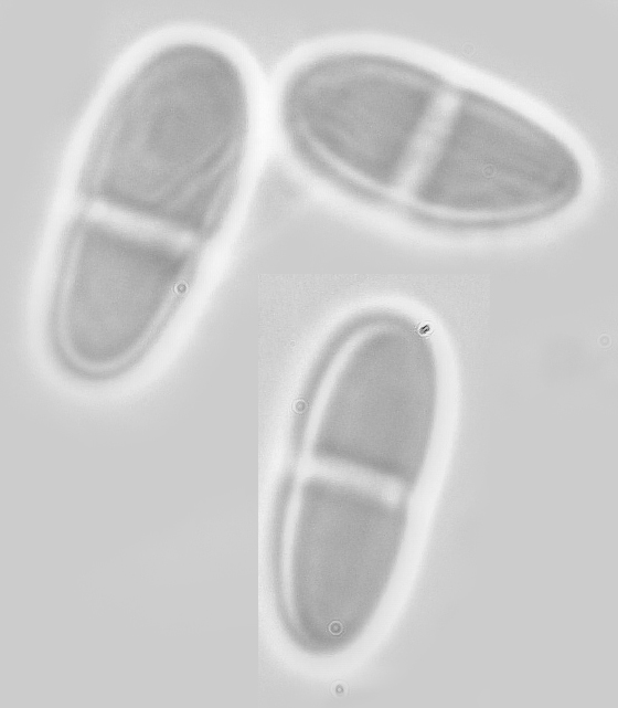
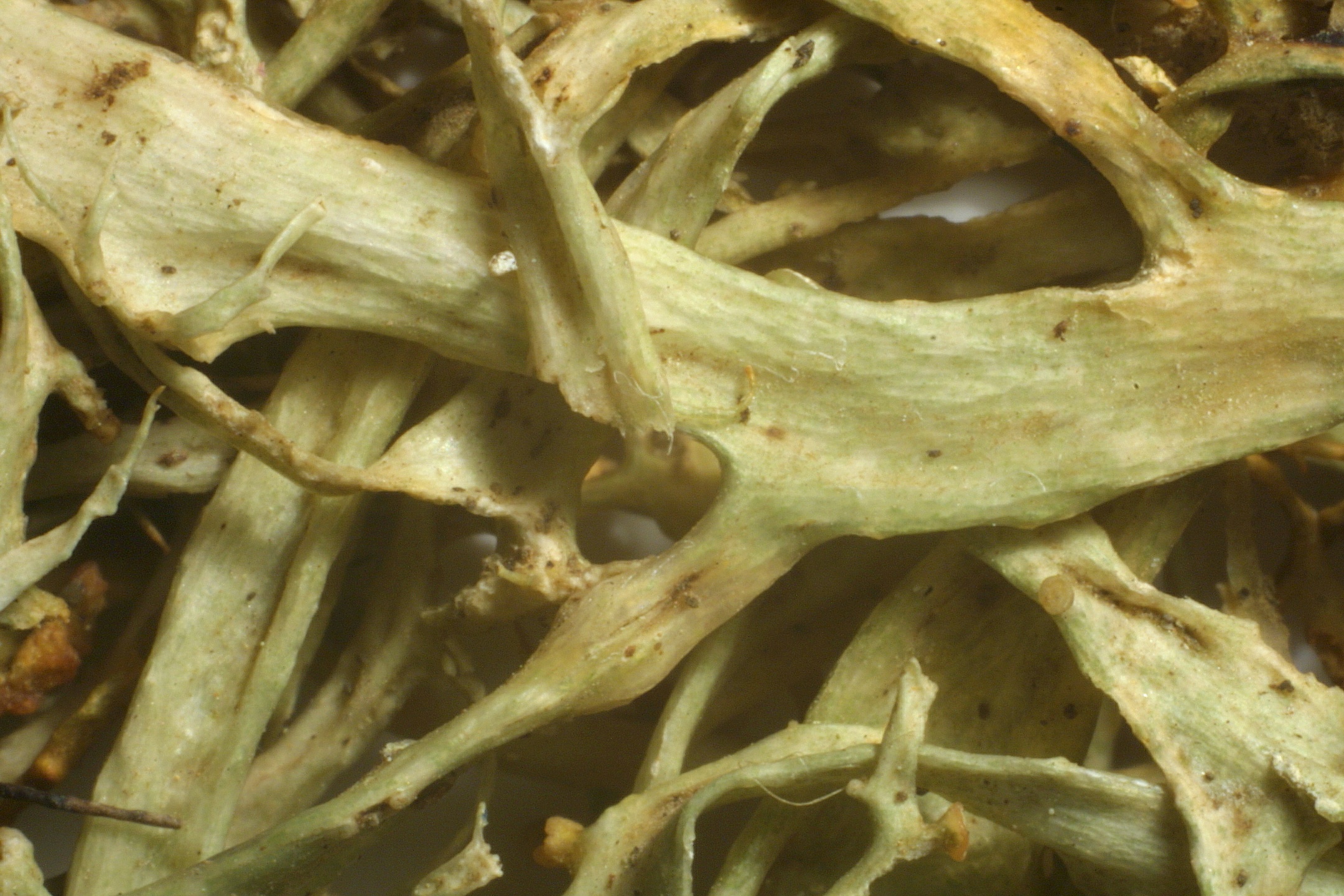
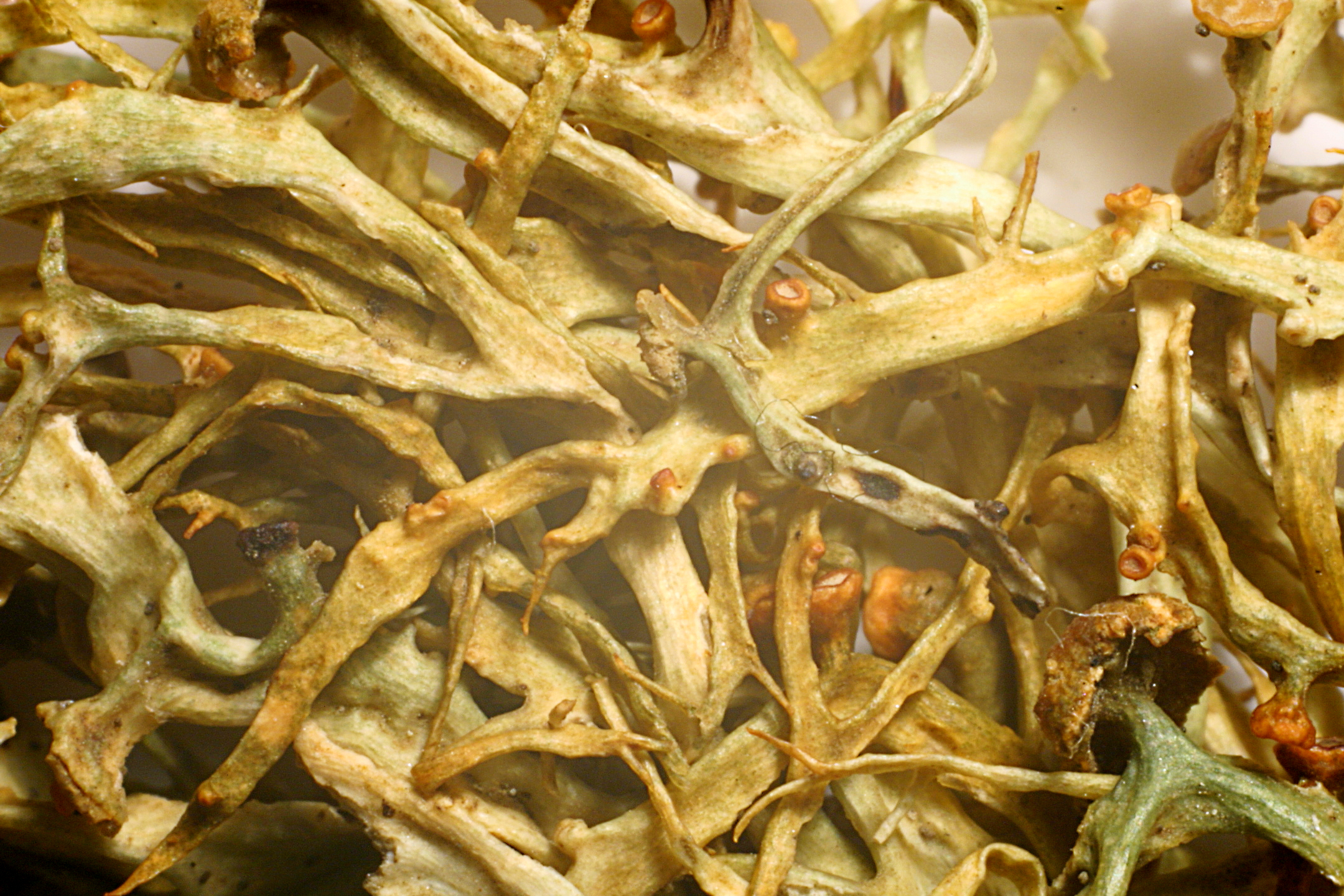
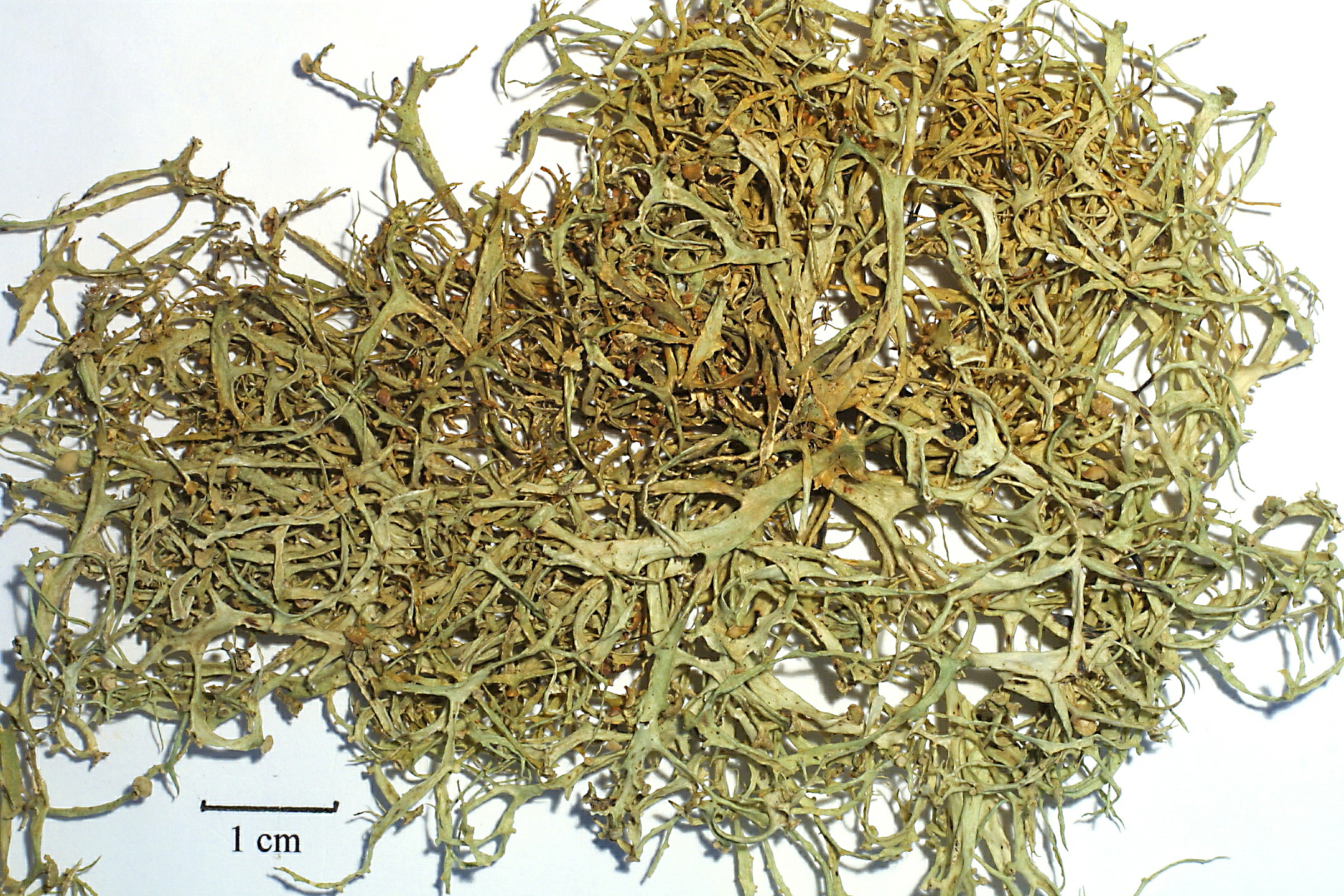
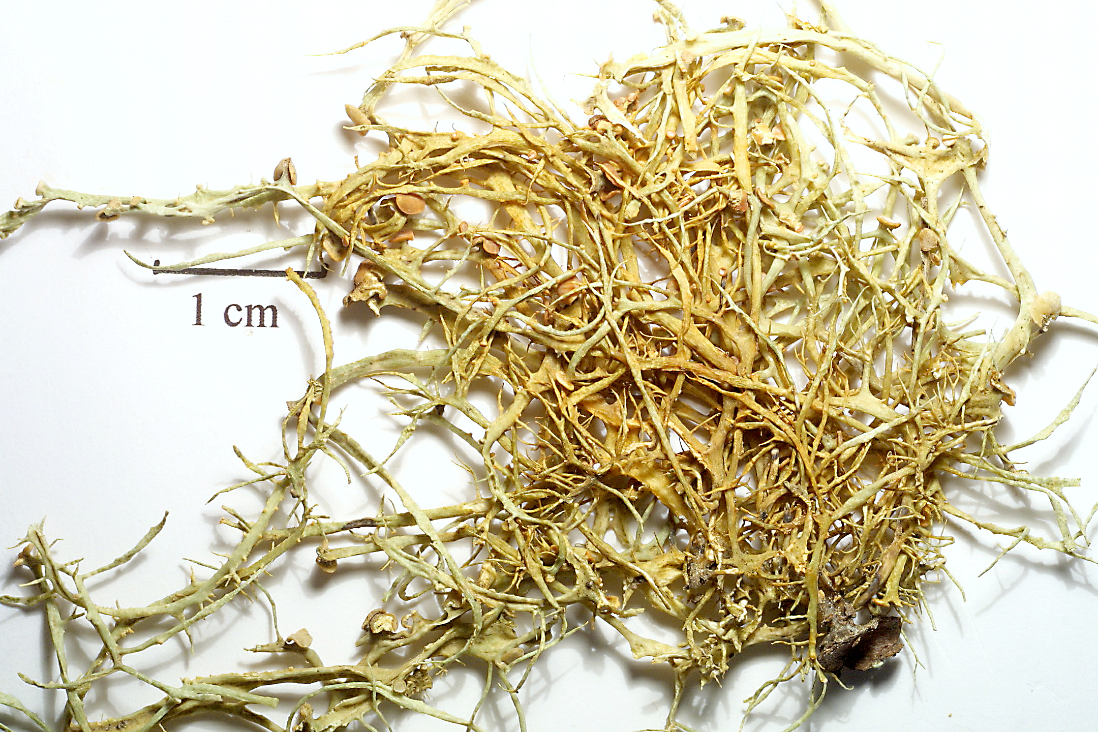
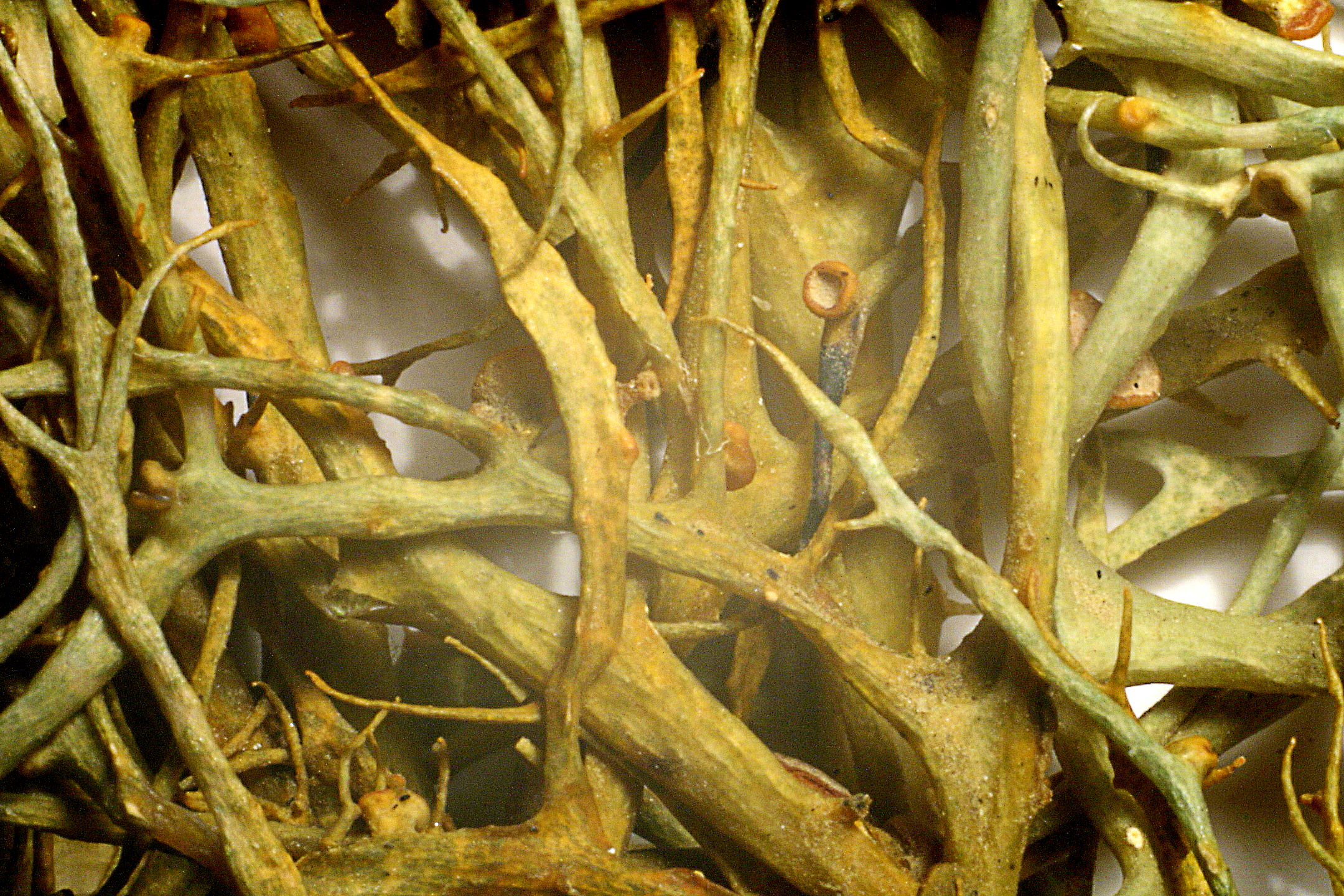
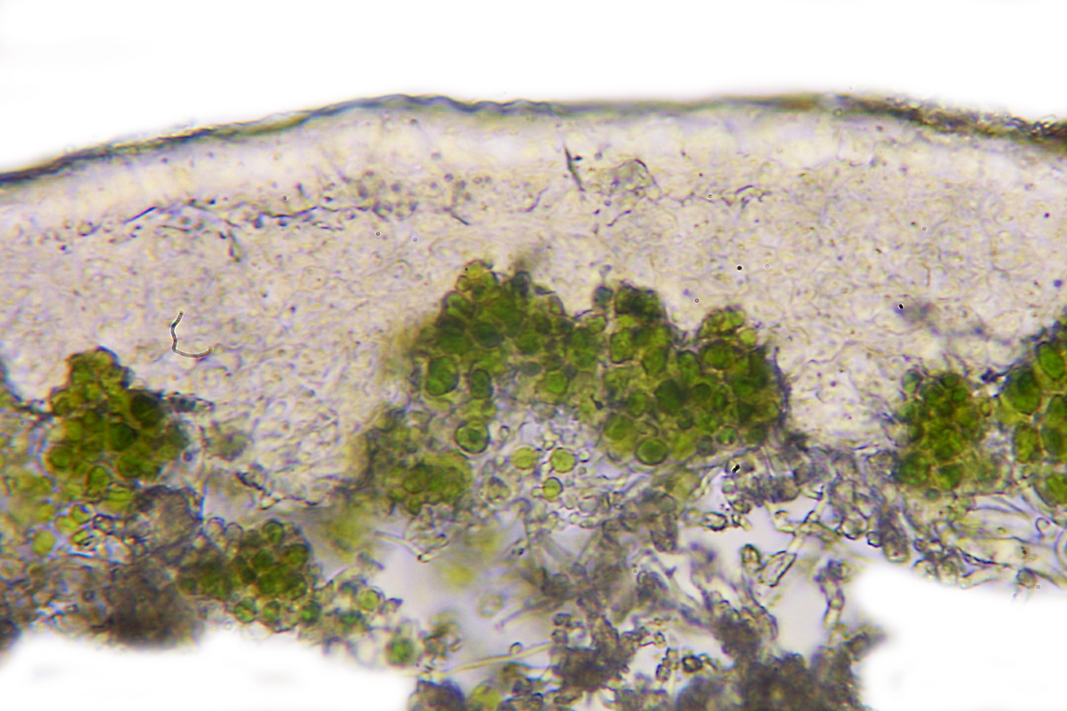
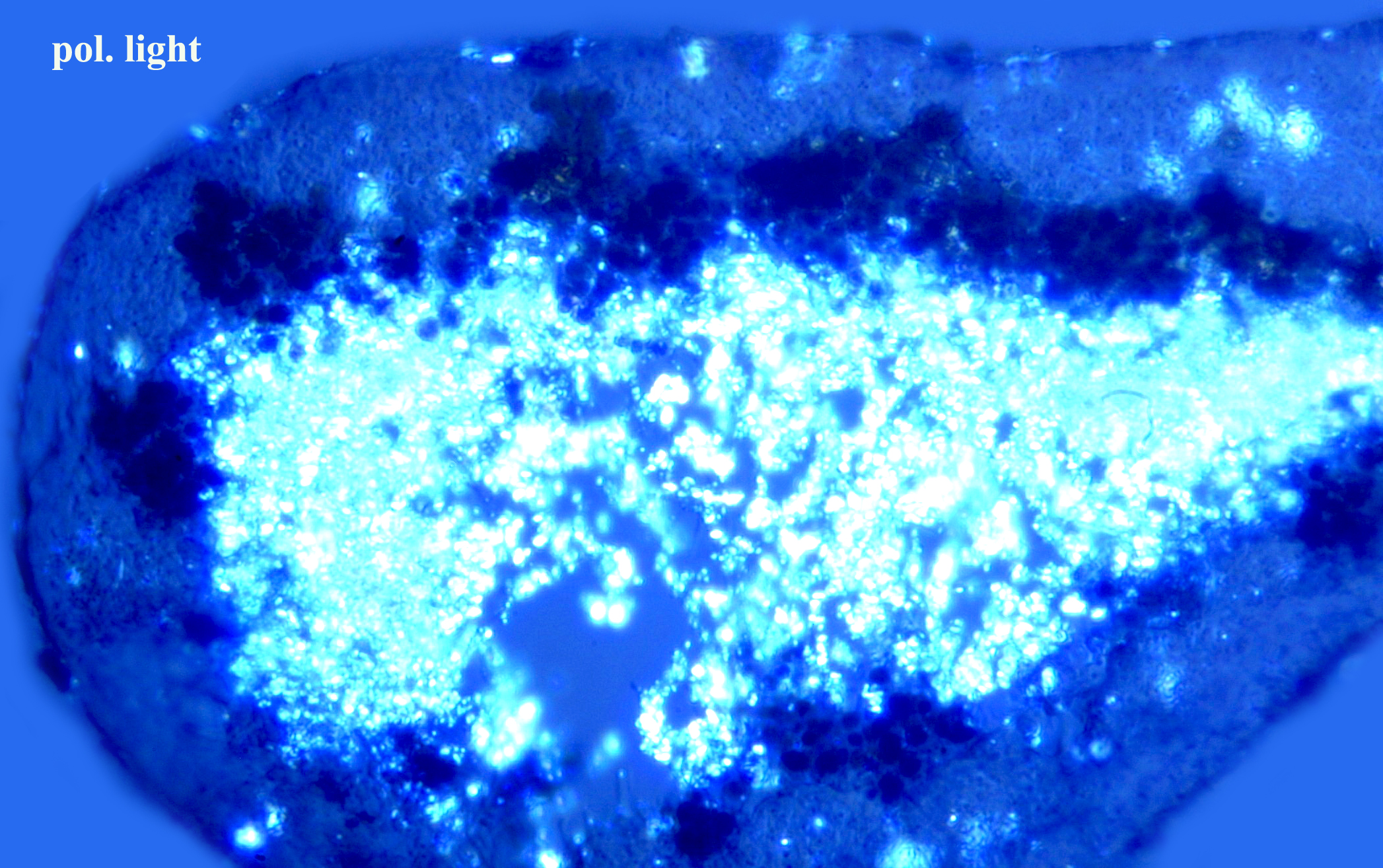
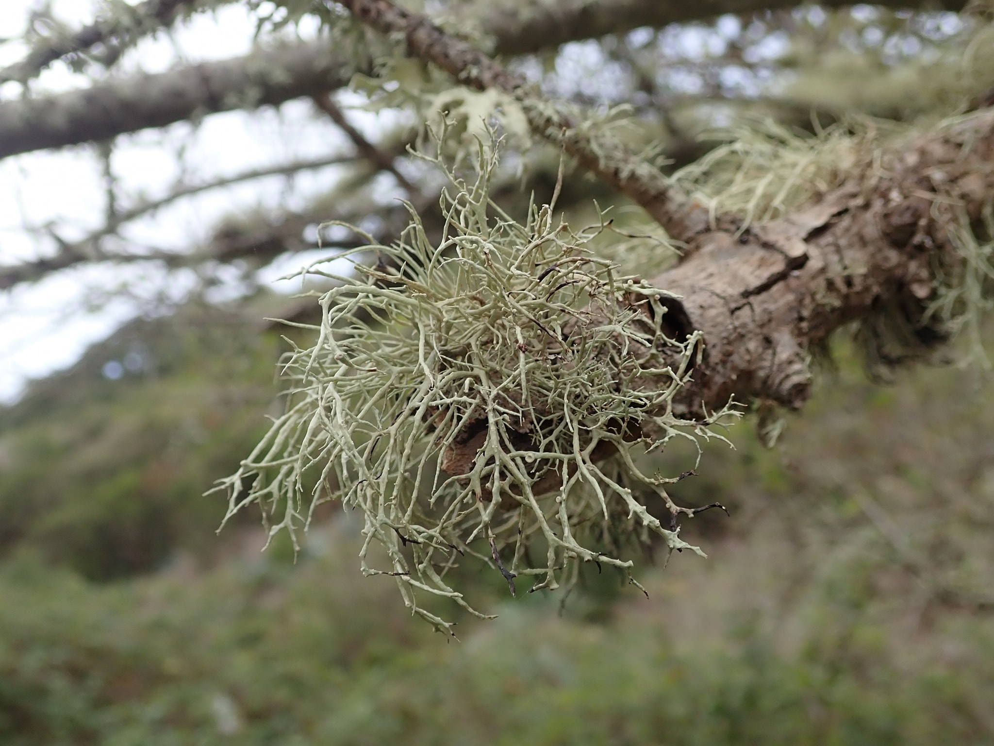
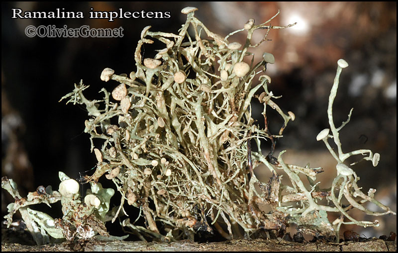
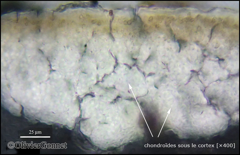
Description: Thallus fruticose, erect to subpendent, yellowish green to straw-coloured, somehow glossy, smooth, formed by 0.5-2 mm wide, up to 14 cm long, sparingly branched, flattened to weakly canaliculate laciniae with pointed, often curved apices, originating from a basal holdfast; pseudocyphellae usually present, short-elongate, slightly raised, mostly marginal, sometimes poorly evident. Cortex 8-15 µm thick, 2-layered, the outer part paraplectenchymatous, the inner part with more or less continuous chondroid strands; medulla white, lax but solid. Apothecia frequent, lecanorine, 2-5 mm across, marginal and subapical, with a yellowish green, flat to convex disc and a smooth thalline margin, often spurred. Epithecium pale olive; hymenium and hypothecium colourless; paraphyses thick-walled, richly branched in upper part. Asci 8-spored, the apical dome K/I+ dark blue with a pale, conical-pointed apical cushion (axial mass), the wall I-, but the thin outer gel I+ blue, Bacidia-type. Ascospores 1-septate (some of them may have a subterminal pseudo-septum), hyaline, ellipsoid, usually not curved, 14-17 x 4-5 µm. Pycnidia laminal, with pale ostioles. Conidia bacilliform. Photobiont chlorococcoid. Spot tests: K- or K+ yellow sometimes turning red, C-, KC-, P- or P+ yellow-orange, UV- or UV+ white. Chemistry: cortex with usnic acid; medulla without lichen substances, or with variable amounts of hypoprotocetraric, protocetraric, salazinic, and/or norstictic acids.
Growth form: Fruticose
Substrata: bark
Photobiont: green algae other than Trentepohlia
Reproductive strategy: mainly sexual
Most common in areas with a humid-warm climate (e.g. most of Tyrrenian Italy)
Commonnes-rarity: (info)
Alpine belt: absent
Subalpine belt: absent
Montane belt: absent
Dry submediterranean belt: absent
Humid submediterranean belt: absent
Padanian area: absent
pH of the substrata:
1 2 3 4 5

Solar irradiation:
1 2 3 4 5
Aridity:
1 2 3 4 5
Eutrophication:
1 2 3 4 5
Poleotolerance:
0 1 2 3
Altitudinal distribution:
1 2 3 4 5 6
Rarity
absent
extremely rare
very rare
rare
rather rare
rather common
common
very common
extremely common
Loading data...
Occurrence data
Predictive map
Felix Schumm - CC BY-SA 4.0
[9156], Spanien, Kanaren, La Gomera: Chorros de Epina, zwischen Arure und Vallehermoso. Im Lorbeer-Erica Wald, 28°09.830' N, 17°17.852 W, 750-850 m, an Ästen. Leg. et det. F. Schumm 10.02.2002.
P.L. Nimis; Owner: Department of Life Sciences, University of Trieste
Herbarium: TSB (18215)
2001/12/04
Felix Schumm - CC BY-SA 4.0
[2812], Südportugal, Algarve: gesellig an lichtoffenem dürren Zweigwerk vereinzelter Laubsträucher im Ramalinetum duriaei, 300 m, NWSW, pH 6,7, Strauchformation in den südwestlichen Ausläufern der Sierra de Monchique unweit Aljezur. Leg. G. Follmann 07.1971, det. H. Krog 12.1979. FOLLMANN: LICH. EXS. SEL. 312.

Felix Schumm - CC BY-SA 4.0
[9156], Spanien, Kanaren, La Gomera: Chorros de Epina, zwischen Arure und Vallehermoso. Im Lorbeer-Erica Wald, 28°09.830' N, 17°17.852 W, 750-850 m, an Ästen. Leg. et det. F. Schumm 10.02.2002.
Felix Schumm - CC BY-SA 4.0
[9156], Spanien, Kanaren, La Gomera: Chorros de Epina, zwischen Arure und Vallehermoso. Im Lorbeer-Erica Wald, 28°09.830' N, 17°17.852 W, 750-850 m, an Ästen. Leg. et det. F. Schumm 10.02.2002.

Felix Schumm - CC BY-SA 4.0
[9156], Spanien, Kanaren, La Gomera: Chorros de Epina, zwischen Arure und Vallehermoso. Im Lorbeer-Erica Wald, 28°09.830' N, 17°17.852 W, 750-850 m, an Ästen. Leg. et det. F. Schumm 10.02.2002.
Felix Schumm - CC BY-SA 4.0
[9156], Spanien, Kanaren, La Gomera: Chorros de Epina, zwischen Arure und Vallehermoso. Im Lorbeer-Erica Wald, 28°09.830' N, 17°17.852 W, 750-850 m, an Ästen. Leg. et det. F. Schumm 10.02.2002.
Felix Schumm - CC BY-SA 4.0
[9156], Spanien, Kanaren, La Gomera: Chorros de Epina, zwischen Arure und Vallehermoso. Im Lorbeer-Erica Wald, 28°09.830' N, 17°17.852 W, 750-850 m, an Ästen. Leg. et det. F. Schumm 10.02.2002.
Felix Schumm - CC BY-SA 4.0
[9156], Spanien, Kanaren, La Gomera: Chorros de Epina, zwischen Arure und Vallehermoso. Im Lorbeer-Erica Wald, 28°09.830' N, 17°17.852 W, 750-850 m, an Ästen. Leg. et det. F. Schumm 10.02.2002.
Felix Schumm - CC BY-SA 4.0
[9163], Spanien, Kanaren, La Gomera: Chorros de Epina, zwischen Arure und Vallehermoso. Im Lorbeer-Erica Wald, 28°09.830' N, 17°17.852 W, 750-850 m, an Rinde. Leg. F. Schumm 10.02.2002, det. F. Schumm 2003.

Felix Schumm - CC BY-SA 4.0
[9163], Spanien, Kanaren, La Gomera: Chorros de Epina, zwischen Arure und Vallehermoso. Im Lorbeer-Erica Wald, 28°09.830' N, 17°17.852 W, 750-850 m, an Rinde. Leg. F. Schumm 10.02.2002, det. F. Schumm 2003.

Felix Schumm - CC BY-SA 4.0
[9163], Spanien, Kanaren, La Gomera: Chorros de Epina, zwischen Arure und Vallehermoso. Im Lorbeer-Erica Wald, 28°09.830' N, 17°17.852 W, 750-850 m, an Rinde. Leg. F. Schumm 10.02.2002, det. F. Schumm 2003.
Felix Schumm - CC BY-SA 4.0
[9163], Spanien, Kanaren, La Gomera: Chorros de Epina, zwischen Arure und Vallehermoso. Im Lorbeer-Erica Wald, 28°09.830' N, 17°17.852 W, 750-850 m, an Rinde. Leg. F. Schumm 10.02.2002, det. F. Schumm 2003.
Felix Schumm - CC BY-SA 4.0
[9164], Spanien, Kanaren, La Gomera: Chorros de Epina, zwischen Arure und Vallehermoso. Im Lorbeer-Erica Wald, 28°09.830' N, 17°17.852 W, 750-850 m, an Rinde. Leg. et det. F. Schumm, 10.02.2002, conf. A. Aptroot 05.2006.

Felix Schumm - CC BY-SA 4.0
[9164], Spanien, Kanaren, La Gomera: Chorros de Epina, zwischen Arure und Vallehermoso. Im Lorbeer-Erica Wald, 28°09.830' N, 17°17.852 W, 750-850 m, an Rinde. Leg. et det. F. Schumm, 10.02.2002, conf. A. Aptroot 05.2006.
Felix Schumm - CC BY-SA 4.0
[9164], Spanien, Kanaren, La Gomera: Chorros de Epina, zwischen Arure und Vallehermoso. Im Lorbeer-Erica Wald, 28°09.830' N, 17°17.852 W, 750-850 m, an Rinde. Leg. et det. F. Schumm, 10.02.2002, conf. A. Aptroot 05.2006.
Felix Schumm - CC BY-SA 4.0
[9380], Spanien, Kanaren, La Gomera: Bei Arure an der Straße nach Las Hayas. Trockener Abhang mit Felsblöcken und Euphorbia. 28°07.895’ N, 17°18.983’ W, 870 m. An altem Feigenbaum. Leg. et det. F. Schumm, 14.02.2002, conf. A. Aptroot 2006
Felix Schumm - CC BY-SA 4.0
[9380], Spanien, Kanaren, La Gomera: Bei Arure an der Straße nach Las Hayas. Trockener Abhang mit Felsblöcken und Euphorbia. 28°07.895’ N, 17°18.983’ W, 870 m. An altem Feigenbaum. Leg. et det. F. Schumm, 14.02.2002, conf. A. Aptroot 2006
Felix Schumm - CC BY-SA 4.0
[9380], Spanien, Kanaren, La Gomera: Bei Arure an der Straße nach Las Hayas. Trockener Abhang mit Felsblöcken und Euphorbia. 28°07.895’ N, 17°18.983’ W, 870 m. An altem Feigenbaum. Leg. et det. F. Schumm, 14.02.2002, conf. A. Aptroot 2006
Felix Schumm - CC BY-SA 4.0
[9380], Spanien, Kanaren, La Gomera: Bei Arure an der Straße nach Las Hayas. Trockener Abhang mit Felsblöcken und Euphorbia. 28°07.895’ N, 17°18.983’ W, 870 m. An altem Feigenbaum. Leg. et det. F. Schumm, 14.02.2002, conf. A. Aptroot 2006
Felix Schumm - CC BY-SA 4.0
[9380], Spanien, Kanaren, La Gomera: Bei Arure an der Straße nach Las Hayas. Trockener Abhang mit Felsblöcken und Euphorbia. 28°07.895’ N, 17°18.983’ W, 870 m. An altem Feigenbaum. Leg. et det. F. Schumm, 14.02.2002, conf. A. Aptroot 2006
Felix Schumm - CC BY-SA 4.0
[9380], Spanien, Kanaren, La Gomera: Bei Arure an der Straße nach Las Hayas. Trockener Abhang mit Felsblöcken und Euphorbia. 28°07.895’ N, 17°18.983’ W, 870 m. An altem Feigenbaum. Leg. et det. F. Schumm, 14.02.2002, conf. A. Aptroot 2006
Felix Schumm – CC BY-SA 4.0
Image from: F. Schumm (2008) - Flechten Madeiras, der Kanaren und Azoren. Beck, OHG - ISBN: 978-3-00-023700-3
Manuel Gil
Spain, Canary Islands, Tenerife
Courtesy Danièle et Olivier Gonnet - Source: https://www.afl-lichenologie.fr/Photos_AFL/Photos_AFL_R/Textes_R2/Ramalina_implectens.htm
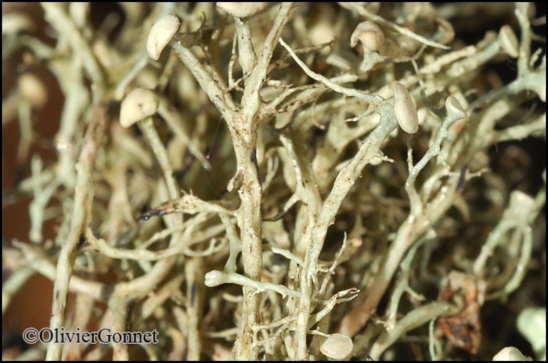
Italy, 14/4/2011 - Montevecchio - Sardaigne
Courtesy Danièle et Olivier Gonnet - Source: https://www.afl-lichenologie.fr/Photos_AFL/Photos_AFL_R/Textes_R2/Ramalina_implectens.htm
Italy, 14/4/2011 - Montevecchio - Sardaigne
Courtesy Danièle et Olivier Gonnet - Source: https://www.afl-lichenologie.fr/Photos_AFL/Photos_AFL_R/Textes_R2/Ramalina_implectens.htm
Italy, 14/4/2011 - Montevecchio - Sardaigne
Courtesy Danièle et Olivier Gonnet - Source: https://www.afl-lichenologie.fr/Photos_AFL/Photos_AFL_R/Textes_R2/Ramalina_implectens.htm
Italy, 14/4/2011 - Montevecchio - Sardaigne
Courtesy Danièle et Olivier Gonnet - Source: https://www.afl-lichenologie.fr/Photos_AFL/Photos_AFL_R/Textes_R2/Ramalina_implectens.htm
Italy, 14/4/2011 - Montevecchio - Sardaigne
Courtesy Danièle et Olivier Gonnet - Source: https://www.afl-lichenologie.fr/Photos_AFL/Photos_AFL_R/Textes_R2/Ramalina_implectens.htm
Italy, 14/4/2011 - Montevecchio - Sardaigne
Felix Schumm - CC BY 4.0
[VZR78], Insulae Canarienses, Gran Canaria: distr. Arucas, secus viaminter vicos Lanzarote et Valleseco, 850 m. In ramulis arborum (Prunussp.). Leg. A. Vezda. EX A. VEZDA: LICHENES RARIORES EXSICCATI NR.78.
Felix Schumm - CC BY 4.0
[VZR78], Insulae Canarienses, Gran Canaria: distr. Arucas, secus viaminter vicos Lanzarote et Valleseco, 850 m. In ramulis arborum (Prunussp.). Leg. A. Vezda. EX A. VEZDA: LICHENES RARIORES EXSICCATI NR.78.
Growth form: Fruticose
Substrata: bark
Photobiont: green algae other than Trentepohlia
Reproductive strategy: mainly sexual
Most common in areas with a humid-warm climate (e.g. most of Tyrrenian Italy)
Commonnes-rarity: (info)
Alpine belt: absent
Subalpine belt: absent
Montane belt: absent
Dry submediterranean belt: absent
Humid submediterranean belt: absent
Padanian area: absent
pH of the substrata:
| 1 | 2 | 3 | 4 | 5 |
Solar irradiation:
| 1 | 2 | 3 | 4 | 5 |
Aridity:
| 1 | 2 | 3 | 4 | 5 |
Eutrophication:
| 1 | 2 | 3 | 4 | 5 |
Poleotolerance:
| 0 | 1 | 2 | 3 |
Altitudinal distribution:
| 1 | 2 | 3 | 4 | 5 | 6 |
Rarity
absent
extremely rare
very rare
rare
rather rare
rather common
common
very common
extremely common
Loading data...
Occurrence data
Predictive map

Felix Schumm - CC BY-SA 4.0
[9156], Spanien, Kanaren, La Gomera: Chorros de Epina, zwischen Arure und Vallehermoso. Im Lorbeer-Erica Wald, 28°09.830' N, 17°17.852 W, 750-850 m, an Ästen. Leg. et det. F. Schumm 10.02.2002.
P.L. Nimis; Owner: Department of Life Sciences, University of Trieste
Herbarium: TSB (18215)
2001/12/04

Felix Schumm - CC BY-SA 4.0
[2812], Südportugal, Algarve: gesellig an lichtoffenem dürren Zweigwerk vereinzelter Laubsträucher im Ramalinetum duriaei, 300 m, NWSW, pH 6,7, Strauchformation in den südwestlichen Ausläufern der Sierra de Monchique unweit Aljezur. Leg. G. Follmann 07.1971, det. H. Krog 12.1979. FOLLMANN: LICH. EXS. SEL. 312.
Felix Schumm - CC BY-SA 4.0
[9156], Spanien, Kanaren, La Gomera: Chorros de Epina, zwischen Arure und Vallehermoso. Im Lorbeer-Erica Wald, 28°09.830' N, 17°17.852 W, 750-850 m, an Ästen. Leg. et det. F. Schumm 10.02.2002.

Felix Schumm - CC BY-SA 4.0
[9156], Spanien, Kanaren, La Gomera: Chorros de Epina, zwischen Arure und Vallehermoso. Im Lorbeer-Erica Wald, 28°09.830' N, 17°17.852 W, 750-850 m, an Ästen. Leg. et det. F. Schumm 10.02.2002.
Felix Schumm - CC BY-SA 4.0
[9156], Spanien, Kanaren, La Gomera: Chorros de Epina, zwischen Arure und Vallehermoso. Im Lorbeer-Erica Wald, 28°09.830' N, 17°17.852 W, 750-850 m, an Ästen. Leg. et det. F. Schumm 10.02.2002.

Felix Schumm - CC BY-SA 4.0
[9156], Spanien, Kanaren, La Gomera: Chorros de Epina, zwischen Arure und Vallehermoso. Im Lorbeer-Erica Wald, 28°09.830' N, 17°17.852 W, 750-850 m, an Ästen. Leg. et det. F. Schumm 10.02.2002.

Felix Schumm - CC BY-SA 4.0
[9156], Spanien, Kanaren, La Gomera: Chorros de Epina, zwischen Arure und Vallehermoso. Im Lorbeer-Erica Wald, 28°09.830' N, 17°17.852 W, 750-850 m, an Ästen. Leg. et det. F. Schumm 10.02.2002.
Felix Schumm - CC BY-SA 4.0
[9156], Spanien, Kanaren, La Gomera: Chorros de Epina, zwischen Arure und Vallehermoso. Im Lorbeer-Erica Wald, 28°09.830' N, 17°17.852 W, 750-850 m, an Ästen. Leg. et det. F. Schumm 10.02.2002.
Felix Schumm - CC BY-SA 4.0
[9163], Spanien, Kanaren, La Gomera: Chorros de Epina, zwischen Arure und Vallehermoso. Im Lorbeer-Erica Wald, 28°09.830' N, 17°17.852 W, 750-850 m, an Rinde. Leg. F. Schumm 10.02.2002, det. F. Schumm 2003.

Felix Schumm - CC BY-SA 4.0
[9163], Spanien, Kanaren, La Gomera: Chorros de Epina, zwischen Arure und Vallehermoso. Im Lorbeer-Erica Wald, 28°09.830' N, 17°17.852 W, 750-850 m, an Rinde. Leg. F. Schumm 10.02.2002, det. F. Schumm 2003.
Felix Schumm - CC BY-SA 4.0
[9163], Spanien, Kanaren, La Gomera: Chorros de Epina, zwischen Arure und Vallehermoso. Im Lorbeer-Erica Wald, 28°09.830' N, 17°17.852 W, 750-850 m, an Rinde. Leg. F. Schumm 10.02.2002, det. F. Schumm 2003.
Felix Schumm - CC BY-SA 4.0
[9163], Spanien, Kanaren, La Gomera: Chorros de Epina, zwischen Arure und Vallehermoso. Im Lorbeer-Erica Wald, 28°09.830' N, 17°17.852 W, 750-850 m, an Rinde. Leg. F. Schumm 10.02.2002, det. F. Schumm 2003.
Felix Schumm - CC BY-SA 4.0
[9164], Spanien, Kanaren, La Gomera: Chorros de Epina, zwischen Arure und Vallehermoso. Im Lorbeer-Erica Wald, 28°09.830' N, 17°17.852 W, 750-850 m, an Rinde. Leg. et det. F. Schumm, 10.02.2002, conf. A. Aptroot 05.2006.
Felix Schumm - CC BY-SA 4.0
[9164], Spanien, Kanaren, La Gomera: Chorros de Epina, zwischen Arure und Vallehermoso. Im Lorbeer-Erica Wald, 28°09.830' N, 17°17.852 W, 750-850 m, an Rinde. Leg. et det. F. Schumm, 10.02.2002, conf. A. Aptroot 05.2006.

Felix Schumm - CC BY-SA 4.0
[9164], Spanien, Kanaren, La Gomera: Chorros de Epina, zwischen Arure und Vallehermoso. Im Lorbeer-Erica Wald, 28°09.830' N, 17°17.852 W, 750-850 m, an Rinde. Leg. et det. F. Schumm, 10.02.2002, conf. A. Aptroot 05.2006.

Felix Schumm - CC BY-SA 4.0
[9380], Spanien, Kanaren, La Gomera: Bei Arure an der Straße nach Las Hayas. Trockener Abhang mit Felsblöcken und Euphorbia. 28°07.895’ N, 17°18.983’ W, 870 m. An altem Feigenbaum. Leg. et det. F. Schumm, 14.02.2002, conf. A. Aptroot 2006

Felix Schumm - CC BY-SA 4.0
[9380], Spanien, Kanaren, La Gomera: Bei Arure an der Straße nach Las Hayas. Trockener Abhang mit Felsblöcken und Euphorbia. 28°07.895’ N, 17°18.983’ W, 870 m. An altem Feigenbaum. Leg. et det. F. Schumm, 14.02.2002, conf. A. Aptroot 2006

Felix Schumm - CC BY-SA 4.0
[9380], Spanien, Kanaren, La Gomera: Bei Arure an der Straße nach Las Hayas. Trockener Abhang mit Felsblöcken und Euphorbia. 28°07.895’ N, 17°18.983’ W, 870 m. An altem Feigenbaum. Leg. et det. F. Schumm, 14.02.2002, conf. A. Aptroot 2006
Felix Schumm - CC BY-SA 4.0
[9380], Spanien, Kanaren, La Gomera: Bei Arure an der Straße nach Las Hayas. Trockener Abhang mit Felsblöcken und Euphorbia. 28°07.895’ N, 17°18.983’ W, 870 m. An altem Feigenbaum. Leg. et det. F. Schumm, 14.02.2002, conf. A. Aptroot 2006

Felix Schumm - CC BY-SA 4.0
[9380], Spanien, Kanaren, La Gomera: Bei Arure an der Straße nach Las Hayas. Trockener Abhang mit Felsblöcken und Euphorbia. 28°07.895’ N, 17°18.983’ W, 870 m. An altem Feigenbaum. Leg. et det. F. Schumm, 14.02.2002, conf. A. Aptroot 2006
Felix Schumm - CC BY-SA 4.0
[9380], Spanien, Kanaren, La Gomera: Bei Arure an der Straße nach Las Hayas. Trockener Abhang mit Felsblöcken und Euphorbia. 28°07.895’ N, 17°18.983’ W, 870 m. An altem Feigenbaum. Leg. et det. F. Schumm, 14.02.2002, conf. A. Aptroot 2006

Felix Schumm – CC BY-SA 4.0
Image from: F. Schumm (2008) - Flechten Madeiras, der Kanaren und Azoren. Beck, OHG - ISBN: 978-3-00-023700-3
Manuel Gil
Spain, Canary Islands, Tenerife
Courtesy Danièle et Olivier Gonnet - Source: https://www.afl-lichenologie.fr/Photos_AFL/Photos_AFL_R/Textes_R2/Ramalina_implectens.htm
Italy, 14/4/2011 - Montevecchio - Sardaigne
Courtesy Danièle et Olivier Gonnet - Source: https://www.afl-lichenologie.fr/Photos_AFL/Photos_AFL_R/Textes_R2/Ramalina_implectens.htm
Italy, 14/4/2011 - Montevecchio - Sardaigne

Courtesy Danièle et Olivier Gonnet - Source: https://www.afl-lichenologie.fr/Photos_AFL/Photos_AFL_R/Textes_R2/Ramalina_implectens.htm
Italy, 14/4/2011 - Montevecchio - Sardaigne

Courtesy Danièle et Olivier Gonnet - Source: https://www.afl-lichenologie.fr/Photos_AFL/Photos_AFL_R/Textes_R2/Ramalina_implectens.htm
Italy, 14/4/2011 - Montevecchio - Sardaigne
Courtesy Danièle et Olivier Gonnet - Source: https://www.afl-lichenologie.fr/Photos_AFL/Photos_AFL_R/Textes_R2/Ramalina_implectens.htm
Italy, 14/4/2011 - Montevecchio - Sardaigne

Courtesy Danièle et Olivier Gonnet - Source: https://www.afl-lichenologie.fr/Photos_AFL/Photos_AFL_R/Textes_R2/Ramalina_implectens.htm
Italy, 14/4/2011 - Montevecchio - Sardaigne

Felix Schumm - CC BY 4.0
[VZR78], Insulae Canarienses, Gran Canaria: distr. Arucas, secus viaminter vicos Lanzarote et Valleseco, 850 m. In ramulis arborum (Prunussp.). Leg. A. Vezda. EX A. VEZDA: LICHENES RARIORES EXSICCATI NR.78.


