
Ramalina panizzei De Not.
Giorn. Bot. Ital., 1: 211, 1846.
Synonyms:
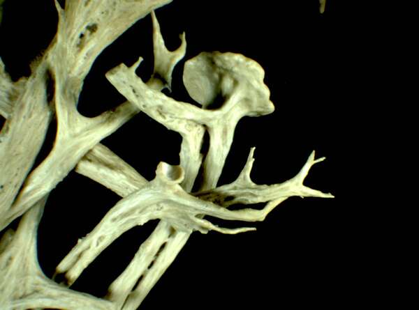
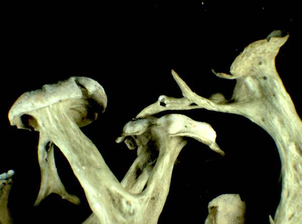
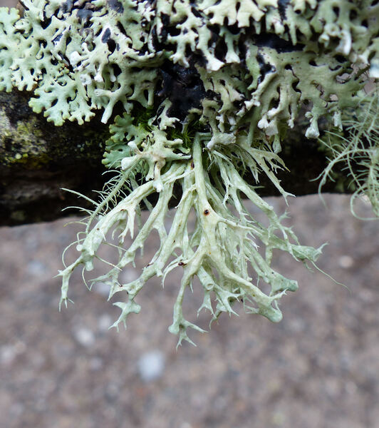
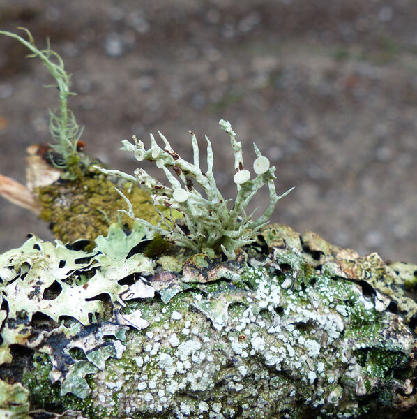
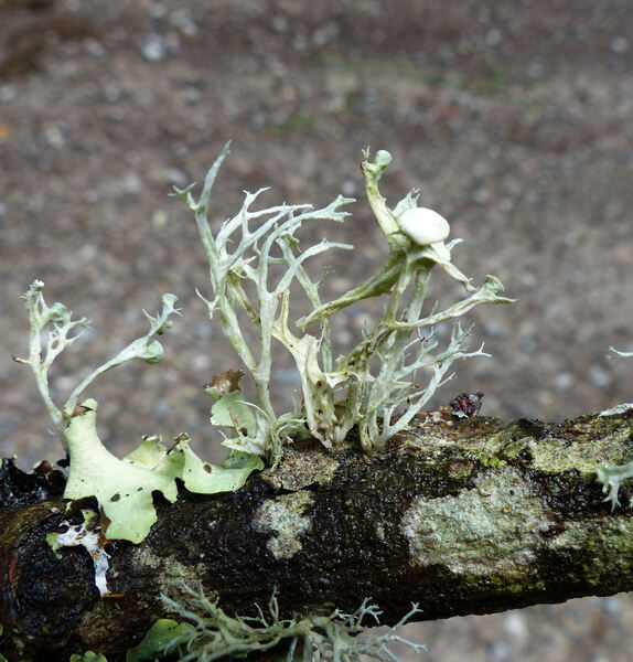
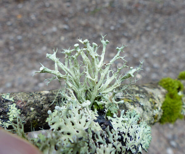
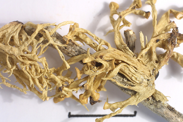
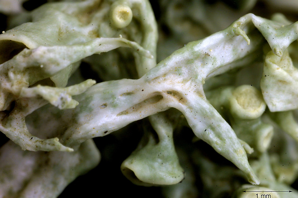
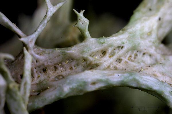
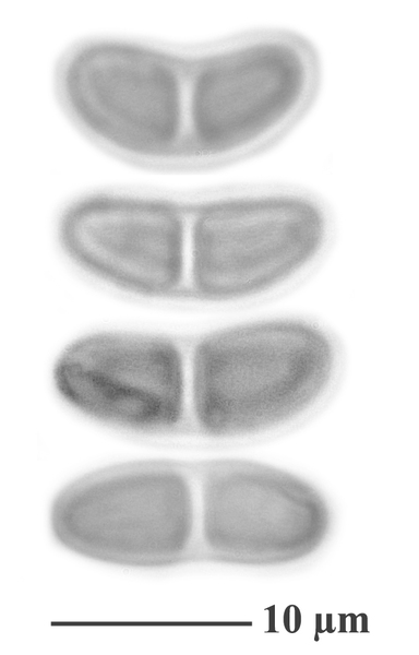
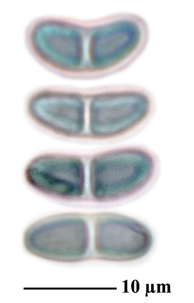
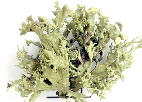
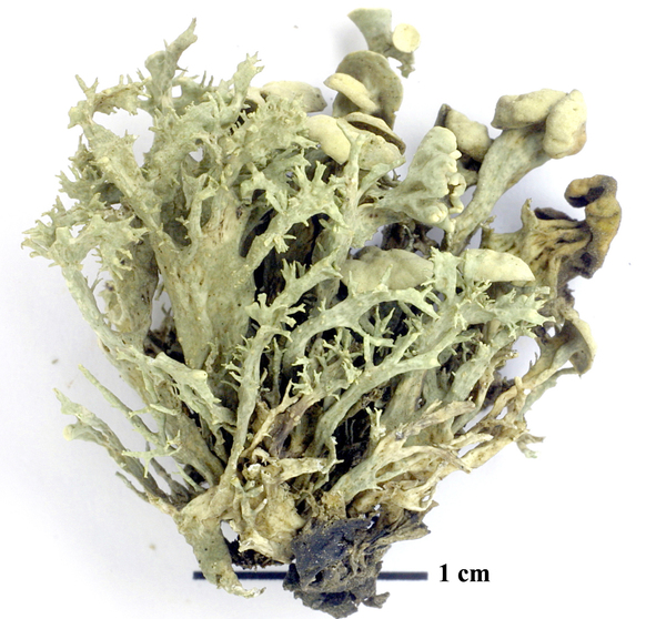
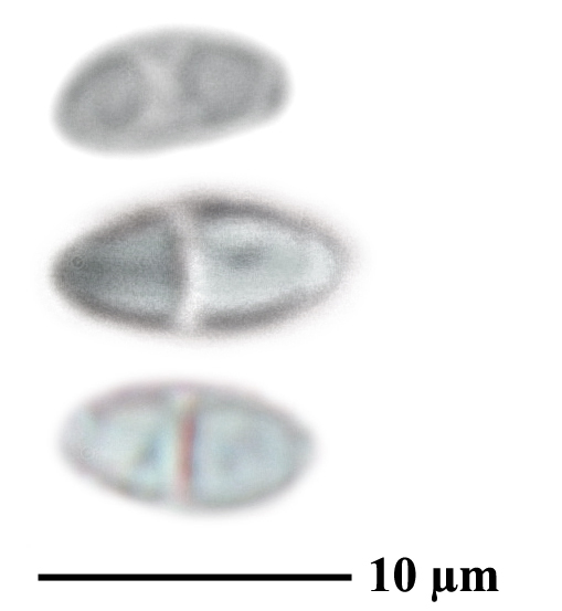
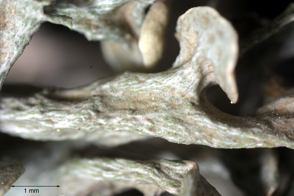
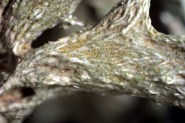
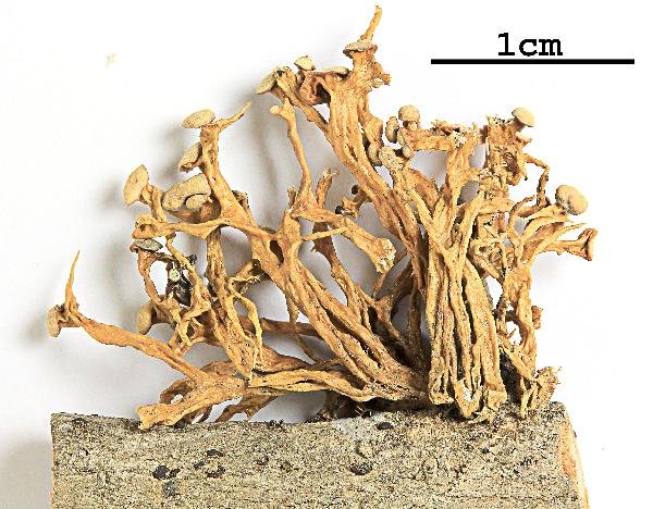
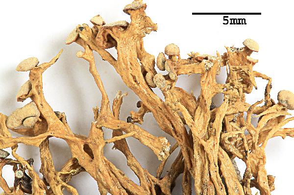
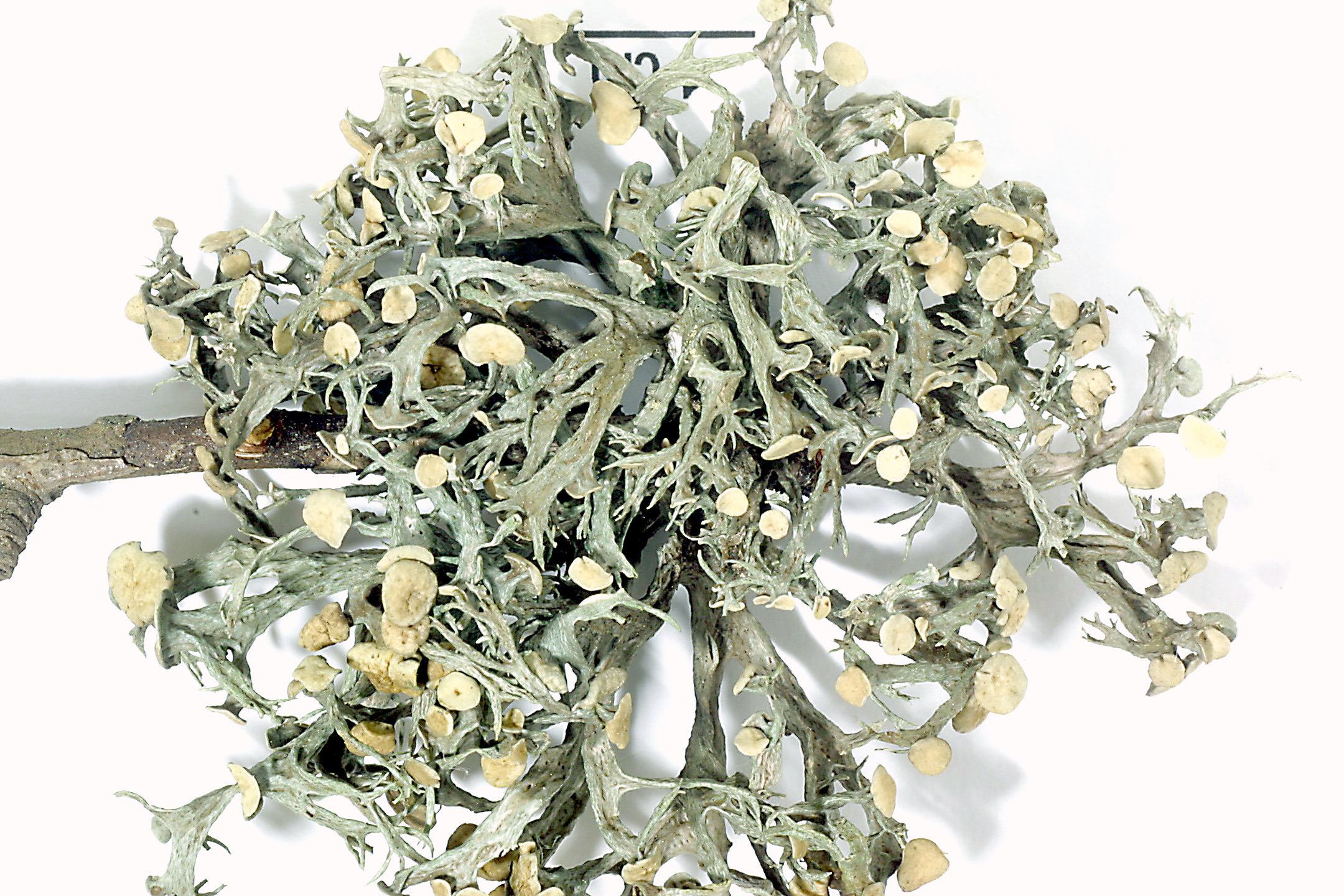
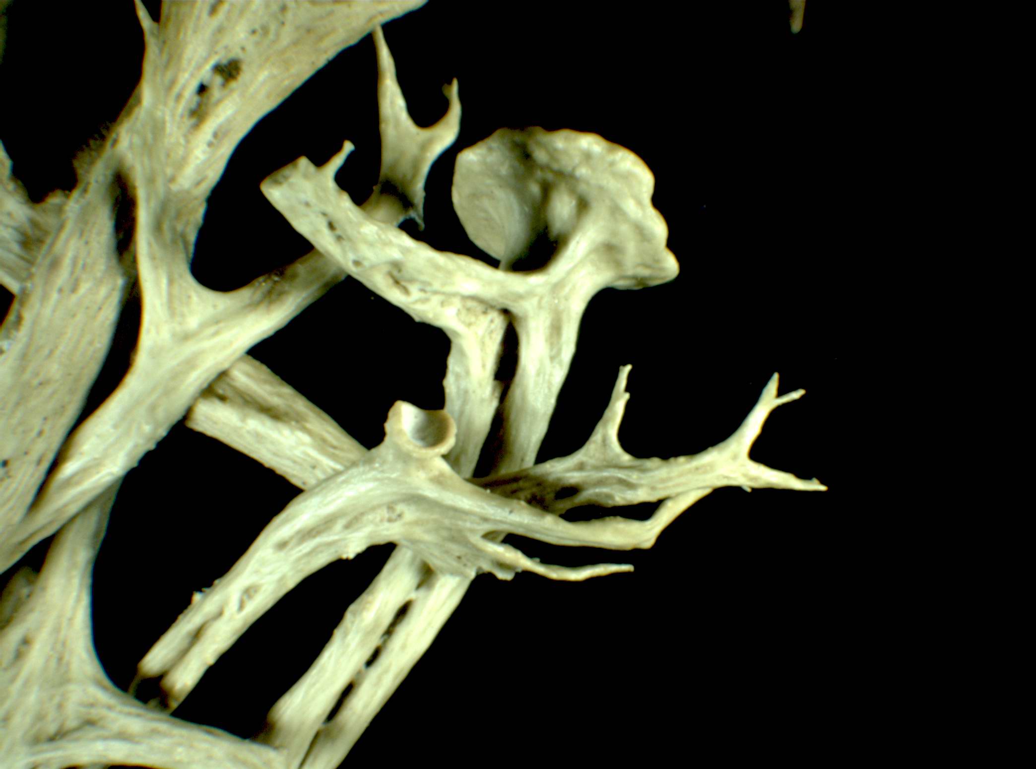
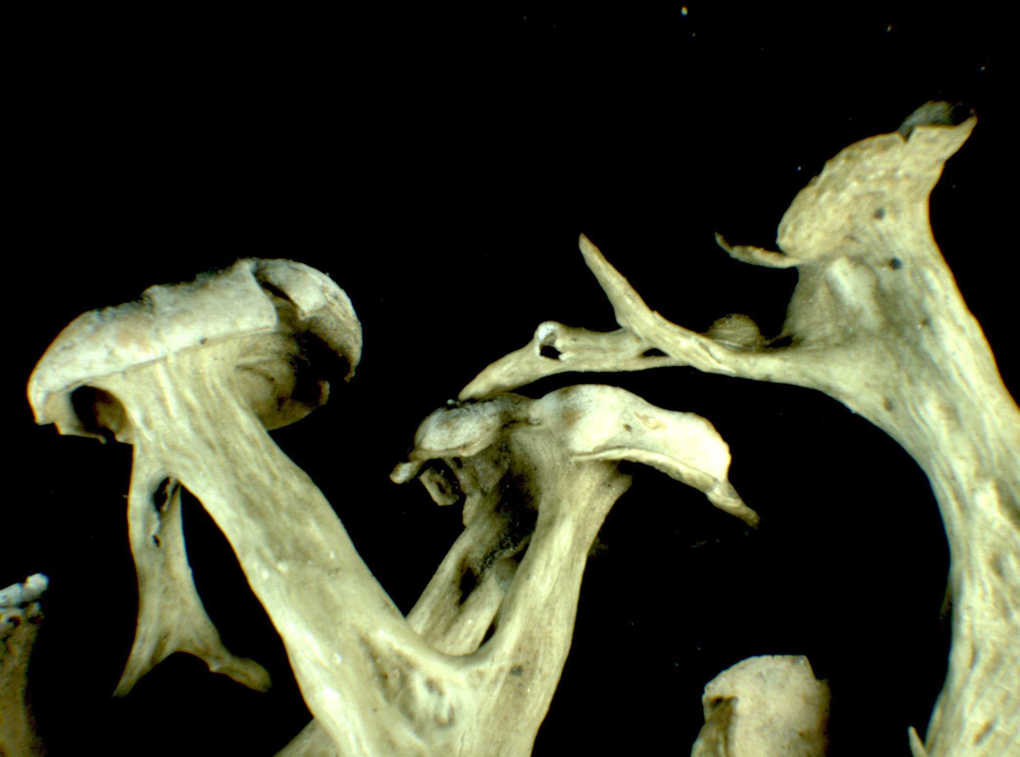
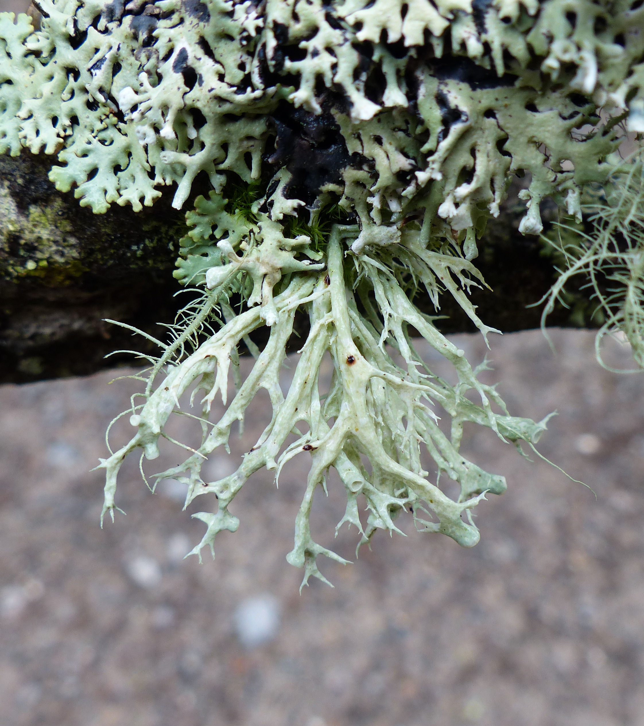
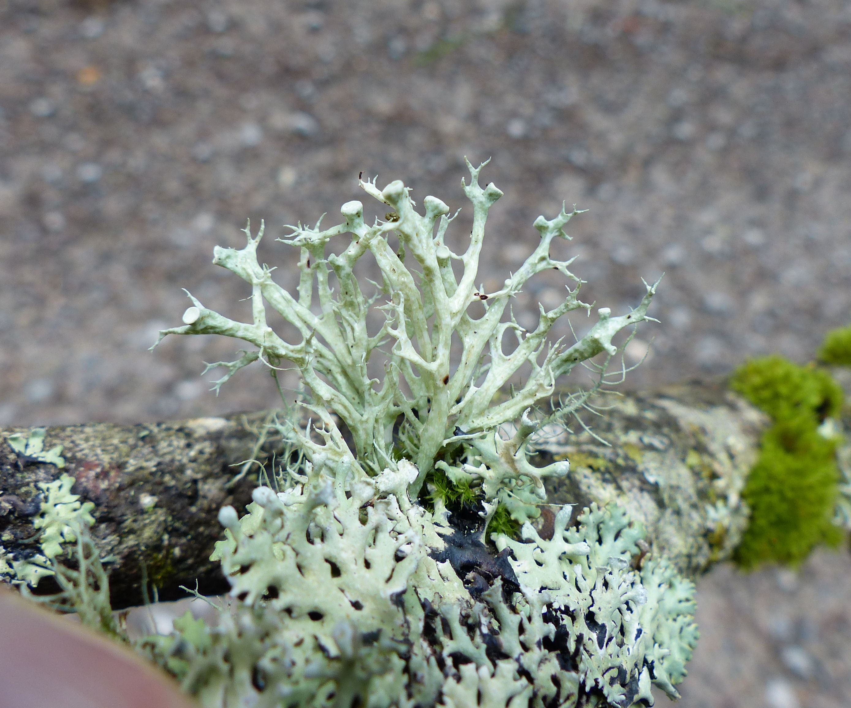
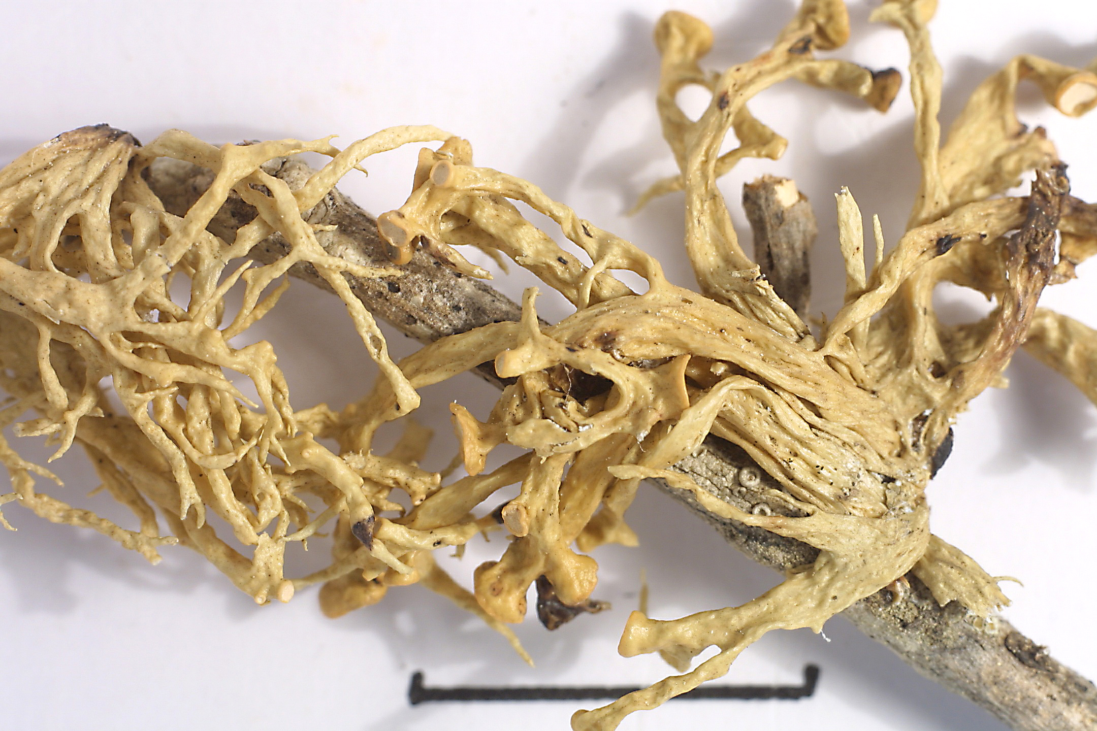
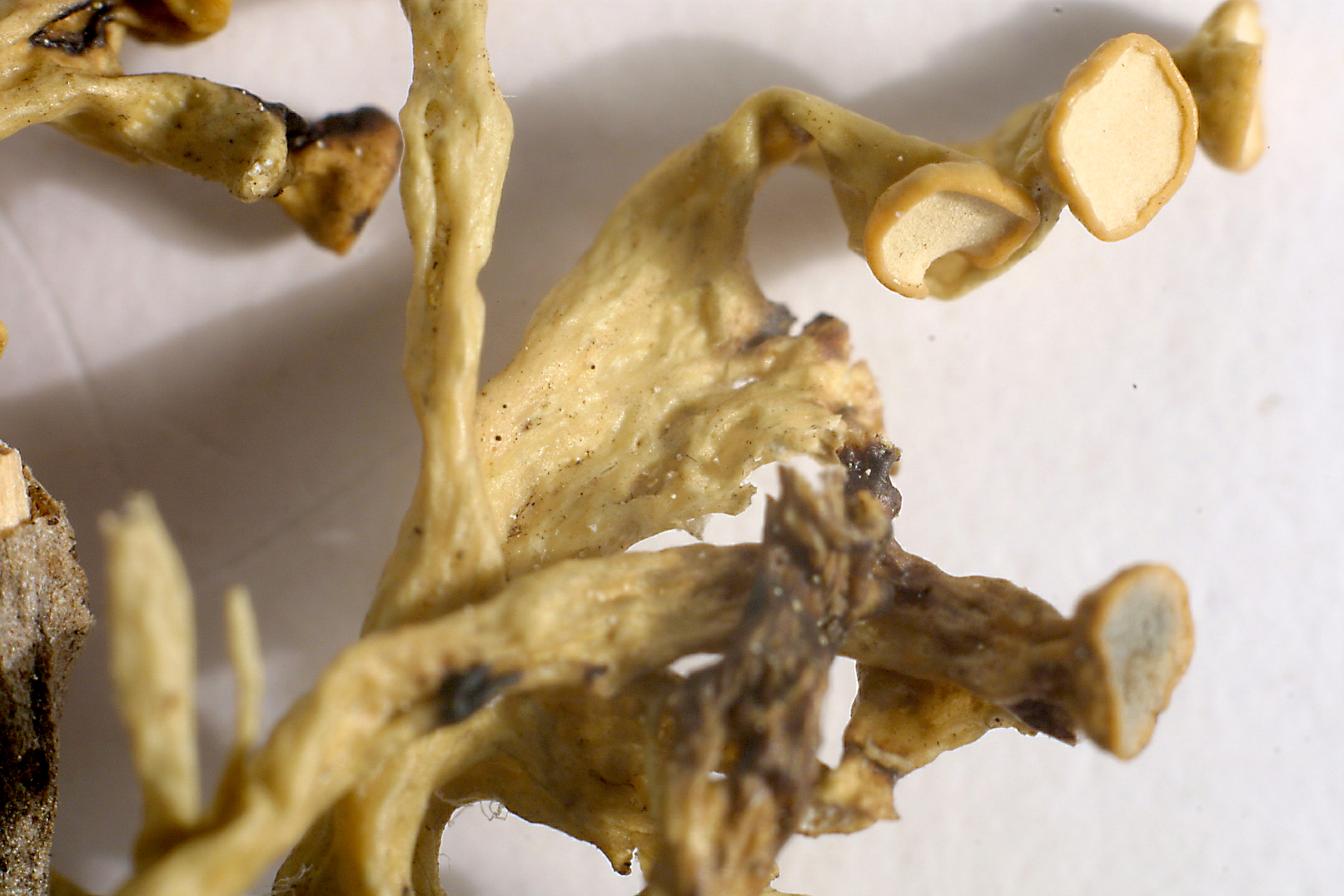
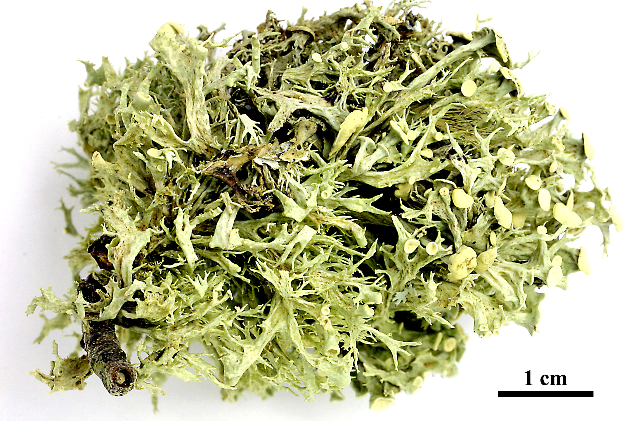
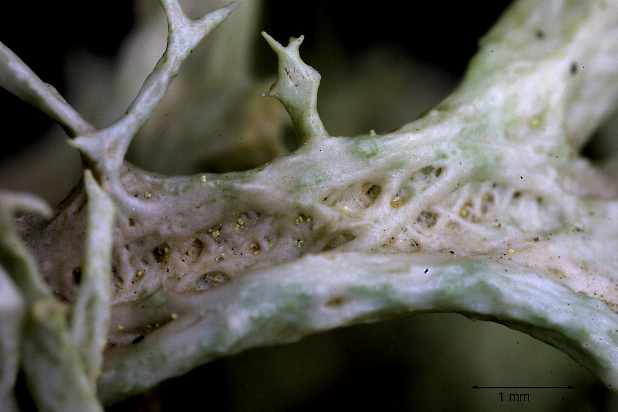
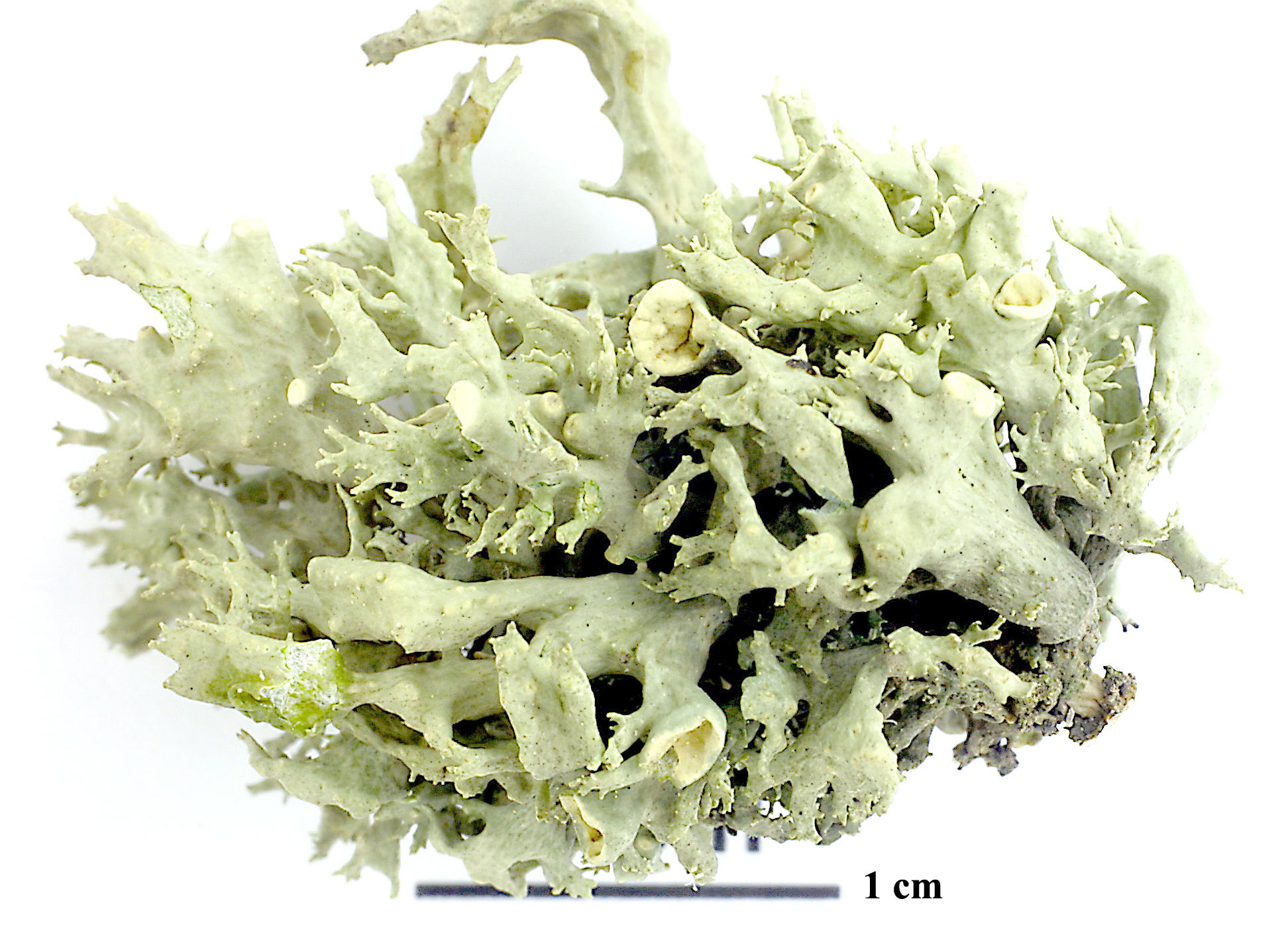
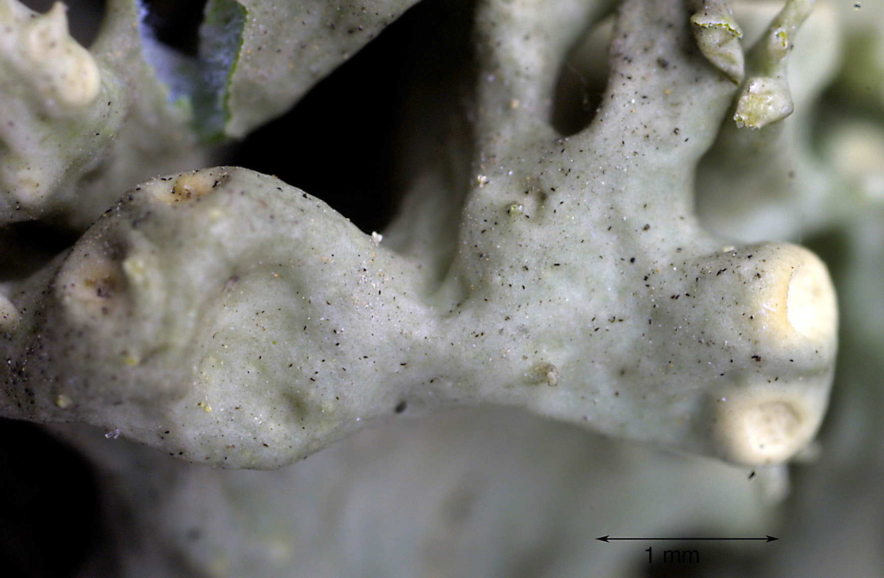
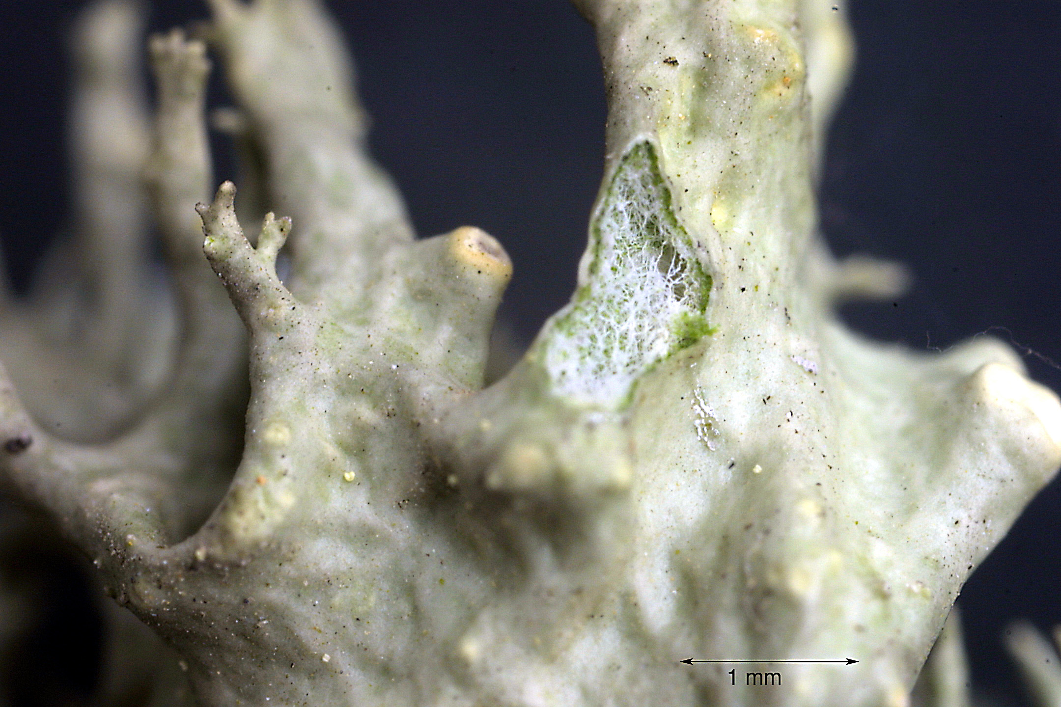
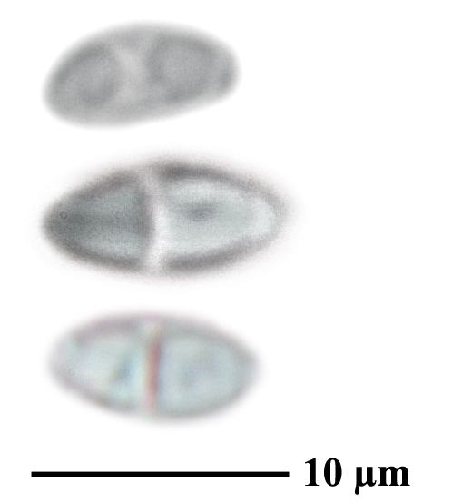
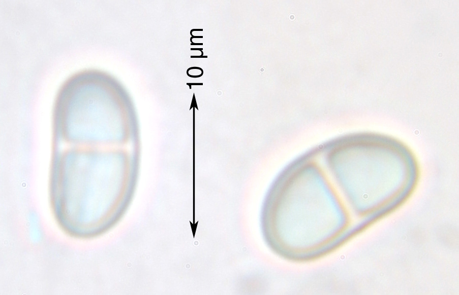
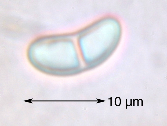
Description: Thallus fruticose, pale yellowish green, to 8 cm tall, erect to ascending, firmly attached by a basal holdfast, moderately branched, forming shrubby, rather rigid tufts. Branches usually compressed and partly fistulose-inflated, 2-5 mm wide at base, with scattered perforations and/or fenestrations. Cortex moderately thick, often cracked or disintegrating in older parts of thallus; medulla white, very lax, especially below the apothecia. Apothecia frequent, lecanorine, with a greenish disc and a thin, smooth thalline margin, mostly terminal or subterminal on smaller branches, but sometimes also lateral, subtended by a short, pointed spur. Epithecium pale brownish-olive; hymenium and hypothecium colourless; paraphyses thick-walled, richly branched in upper part. Asci 8-spored, the apical dome K/I+ dark blue with a pale, conical-pointed apical cushion (axial mass), the wall I-, but the thin outer gel I+ blue, Bacidia-type. Ascospores 1-septate, hyaline, mostly curved, (9-)11-15(-16) x 4-6 µm. Photobiont: chlorococcoid. Spot tests: K-, C-, KC- or KC+ pale yellow (cortex only), P-, UV-. Chemistry: cortex with usnic acid; medulla with homosekikaic and sekikaic acids.
Growth form: Fruticose
Substrata: bark
Photobiont: green algae other than Trentepohlia
Reproductive strategy: mainly sexual
Commonnes-rarity: (info)
Alpine belt: absent
Subalpine belt: absent
Montane belt: very rare
Dry submediterranean belt: absent
Humid submediterranean belt: absent
Padanian area: absent
pH of the substrata:
1 2 3 4 5

Solar irradiation:
1 2 3 4 5
Aridity:
1 2 3 4 5
Eutrophication:
1 2 3 4 5
Poleotolerance:
0 1 2 3
Altitudinal distribution:
1 2 3 4 5 6
Rarity
absent
extremely rare
very rare
rare
rather rare
rather common
common
very common
extremely common
Loading data...
Occurrence data
Predictive map

Felix Schumm - CC BY-SA 4.0
[12496], Griechenland, W-Samos, beim Mt. Kerketeas, 37°44.279'N, 26°40.224'E, 617 m. Leg. F. Schumm, R. Düll & Wunder, 13.05.2006, det. A. Aptroot, 2007, Dupl. an Aptroot.
P.L. Nimis; Owner: Department of Life Sciences, University of Trieste
Herbarium: TSB (13854)
2001/12/09
P.L. Nimis; Owner: Department of Life Sciences, University of Trieste
Herbarium: TSB (13854)
2001/12/09
Andrea Moro; Owner: Department of Life Sciences, University of Trieste
Italy, Friuli Venezia Giulia, Udine, Lago di Sauris, Bosco della Stua, Carnic Alps (Ampezzo Carnico) 1000 m; altitude: 1000 m
12/08/2017
Andrea Moro; Owner: Department of Life Sciences, University of Trieste
Italy, Friuli Venezia Giulia, Udine, Lago di Sauris, Bosco della Stua, Carnic Alps (Ampezzo Carnico) 1000 m; altitude: 1000 m
12/08/2017
Andrea Moro; Owner: Department of Life Sciences, University of Trieste
Italy, Friuli Venezia Giulia, Udine, Lago di Sauris, Bosco della Stua, Carnic Alps (Ampezzo Carnico) 1000 m; altitude: 1000 m
12/08/2017
Andrea Moro; Owner: Department of Life Sciences, University of Trieste
Italy, Friuli Venezia Giulia, Udine, Lago di Sauris, Bosco della Stua, Carnic Alps (Ampezzo Carnico) 1000 m; altitude: 1000 m
12/08/2017
Felix Schumm - CC BY-SA 4.0
[2694], Südfrankreich, Iles d`Hyères: dichtbuschig in windoffenen, diffus belichteten jungen Zweigwerk des unteren Kronenteils solitärer Ölbäume im Ramalinetum fastigiatae, 60 m, pH 6,7, lichte Olivenhaine im Vallée La Solitude auf der Ile de Port-Cros. Leg. Y. Rondon 05.1971, det. Y. Rondon. FOLLMANN: NR. 251 LICH. EXS. SEL.

Felix Schumm - CC BY-SA 4.0
[12368], Griechenland, N-Samos, südlich Avlakia an der Straße oberhalb Vourliotes nördlich des Bergmassivs Lazarou, 37°48'N, 26°51'E, ca. 798 m. Leg. F. Schumm, R. Düll & Maier, 03.05.2006, det. A. Aptroot, 2007.
Felix Schumm - CC BY-SA 4.0
[12368], Griechenland, N-Samos, südlich Avlakia an der Straße oberhalb Vourliotes nördlich des Bergmassivs Lazarou, 37°48'N, 26°51'E, ca. 798 m. Leg. F. Schumm, R. Düll & Maier, 03.05.2006, det. A. Aptroot, 2007.
Felix Schumm - CC BY-SA 4.0
[12368], Griechenland, N-Samos, südlich Avlakia an der Straße oberhalb Vourliotes nördlich des Bergmassivs Lazarou, 37°48'N, 26°51'E, ca. 798 m. Leg. F. Schumm, R. Düll & Maier, 03.05.2006, det. A. Aptroot, 2007.
Felix Schumm - CC BY-SA 4.0
[12368], Griechenland, N-Samos, südlich Avlakia an der Straße oberhalb Vourliotes nördlich des Bergmassivs Lazarou, 37°48'N, 26°51'E, ca. 798 m. Leg. F. Schumm, R. Düll & Maier, 03.05.2006, det. A. Aptroot, 2007.
Felix Schumm - CC BY-SA 4.0
[12368], Griechenland, N-Samos, südlich Avlakia an der Straße oberhalb Vourliotes nördlich des Bergmassivs Lazarou, 37°48'N, 26°51'E, ca. 798 m. Leg. F. Schumm, R. Düll & Maier, 03.05.2006, det. A. Aptroot, 2007.
Felix Schumm - CC BY-SA 4.0
[12384], Griechenland, N-Samos, südlich Avlakia an der Straße oberhalb Vourliotes nördlich des Bergmassivs Lazarou, 37°48'N, 26°51'E, ca. 774 m, an Juglans. Leg. F. Schumm, R. Düll & Maier, 03.05.2006, det. A. Aptroot, 2007. Dubl. an A. Aptroot.
Felix Schumm - CC BY-SA 4.0
[12384], Griechenland, N-Samos, südlich Avlakia an der Straße oberhalb Vourliotes nördlich des Bergmassivs Lazarou, 37°48'N, 26°51'E, ca. 774 m, an Juglans. Leg. F. Schumm, R. Düll & Maier, 03.05.2006, det. A. Aptroot, 2007. Dubl. an A. Aptroot.

Felix Schumm - CC BY-SA 4.0
[12384], Griechenland, N-Samos, südlich Avlakia an der Straße oberhalb Vourliotes nördlich des Bergmassivs Lazarou, 37°48'N, 26°51'E, ca. 774 m, an Juglans. Leg. F. Schumm, R. Düll & Maier, 03.05.2006, det. A. Aptroot, 2007. Dubl. an A. Aptroot.

Felix Schumm - CC BY-SA 4.0
[12384], Griechenland, N-Samos, südlich Avlakia an der Straße oberhalb Vourliotes nördlich des Bergmassivs Lazarou, 37°48'N, 26°51'E, ca. 774 m, an Juglans. Leg. F. Schumm, R. Düll & Maier, 03.05.2006, det. A. Aptroot, 2007. Dubl. an A. Aptroot.

Felix Schumm - CC BY-SA 4.0
[12384], Griechenland, N-Samos, südlich Avlakia an der Straße oberhalb Vourliotes nördlich des Bergmassivs Lazarou, 37°48'N, 26°51'E, ca. 774 m, an Juglans. Leg. F. Schumm, R. Düll & Maier, 03.05.2006, det. A. Aptroot, 2007. Dubl. an A. Aptroot.
Felix Schumm - CC BY-SA 4.0
[12384], Griechenland, N-Samos, südlich Avlakia an der Straße oberhalb Vourliotes nördlich des Bergmassivs Lazarou, 37°48'N, 26°51'E, ca. 774 m, an Juglans. Leg. F. Schumm, R. Düll & Maier, 03.05.2006, det. A. Aptroot, 2007. Dubl. an A. Aptroot.
Felix Schumm - CC BY-SA 4.0
[12496], Griechenland, W-Samos, beim Mt. Kerketeas, 37°44.279'N, 26°40.224'E, 617 m. Leg. F. Schumm, R. Düll & Wunder, 13.05.2006, det. A. Aptroot, 2007, Dupl. an Aptroot.
Felix Schumm - CC BY-SA 4.0
[12496], Griechenland, W-Samos, beim Mt. Kerketeas, 37°44.279'N, 26°40.224'E, 617 m. Leg. F. Schumm, R. Düll & Wunder, 13.05.2006, det. A. Aptroot, 2007, Dupl. an Aptroot.

Felix Schumm - CC BY-SA 4.0
[12496], Griechenland, W-Samos, beim Mt. Kerketeas, 37°44.279'N, 26°40.224'E, 617 m. Leg. F. Schumm, R. Düll & Wunder, 13.05.2006, det. A. Aptroot, 2007, Dupl. an Aptroot.

Felix Schumm - CC BY-SA 4.0
[12496], Griechenland, W-Samos, beim Mt. Kerketeas, 37°44.279'N, 26°40.224'E, 617 m. Leg. F. Schumm, R. Düll & Wunder, 13.05.2006, det. A. Aptroot, 2007, Dupl. an Aptroot.
Felix Schumm - CC BY 4.0
[VZ1018], Gallia. Var, insula Port-Cros, in valle La Solitude, 60 m.Corticola in ramulos Oleae europeae. Leg. Y. Rondon, 30.05.1971. EXA. VEZDA: LICHENES SELECTI EXSICCATI NR. 1017.
Felix Schumm - CC BY 4.0
[VZ1018], Gallia. Var, insula Port-Cros, in valle La Solitude, 60 m.Corticola in ramulos Oleae europeae. Leg. Y. Rondon, 30.05.1971. EXA. VEZDA: LICHENES SELECTI EXSICCATI NR. 1017.
Growth form: Fruticose
Substrata: bark
Photobiont: green algae other than Trentepohlia
Reproductive strategy: mainly sexual
Commonnes-rarity: (info)
Alpine belt: absent
Subalpine belt: absent
Montane belt: very rare
Dry submediterranean belt: absent
Humid submediterranean belt: absent
Padanian area: absent
pH of the substrata:
| 1 | 2 | 3 | 4 | 5 |
Solar irradiation:
| 1 | 2 | 3 | 4 | 5 |
Aridity:
| 1 | 2 | 3 | 4 | 5 |
Eutrophication:
| 1 | 2 | 3 | 4 | 5 |
Poleotolerance:
| 0 | 1 | 2 | 3 |
Altitudinal distribution:
| 1 | 2 | 3 | 4 | 5 | 6 |
Rarity
absent
extremely rare
very rare
rare
rather rare
rather common
common
very common
extremely common
Loading data...
Occurrence data
Predictive map
Felix Schumm - CC BY-SA 4.0
[12496], Griechenland, W-Samos, beim Mt. Kerketeas, 37°44.279'N, 26°40.224'E, 617 m. Leg. F. Schumm, R. Düll & Wunder, 13.05.2006, det. A. Aptroot, 2007, Dupl. an Aptroot.
P.L. Nimis; Owner: Department of Life Sciences, University of Trieste
Herbarium: TSB (13854)
2001/12/09
P.L. Nimis; Owner: Department of Life Sciences, University of Trieste
Herbarium: TSB (13854)
2001/12/09
Andrea Moro; Owner: Department of Life Sciences, University of Trieste
Italy, Friuli Venezia Giulia, Udine, Lago di Sauris, Bosco della Stua, Carnic Alps (Ampezzo Carnico) 1000 m; altitude: 1000 m
12/08/2017

Andrea Moro; Owner: Department of Life Sciences, University of Trieste
Italy, Friuli Venezia Giulia, Udine, Lago di Sauris, Bosco della Stua, Carnic Alps (Ampezzo Carnico) 1000 m; altitude: 1000 m
12/08/2017

Andrea Moro; Owner: Department of Life Sciences, University of Trieste
Italy, Friuli Venezia Giulia, Udine, Lago di Sauris, Bosco della Stua, Carnic Alps (Ampezzo Carnico) 1000 m; altitude: 1000 m
12/08/2017
Andrea Moro; Owner: Department of Life Sciences, University of Trieste
Italy, Friuli Venezia Giulia, Udine, Lago di Sauris, Bosco della Stua, Carnic Alps (Ampezzo Carnico) 1000 m; altitude: 1000 m
12/08/2017
Felix Schumm - CC BY-SA 4.0
[2694], Südfrankreich, Iles d`Hyères: dichtbuschig in windoffenen, diffus belichteten jungen Zweigwerk des unteren Kronenteils solitärer Ölbäume im Ramalinetum fastigiatae, 60 m, pH 6,7, lichte Olivenhaine im Vallée La Solitude auf der Ile de Port-Cros. Leg. Y. Rondon 05.1971, det. Y. Rondon. FOLLMANN: NR. 251 LICH. EXS. SEL.
Felix Schumm - CC BY-SA 4.0
[12368], Griechenland, N-Samos, südlich Avlakia an der Straße oberhalb Vourliotes nördlich des Bergmassivs Lazarou, 37°48'N, 26°51'E, ca. 798 m. Leg. F. Schumm, R. Düll & Maier, 03.05.2006, det. A. Aptroot, 2007.

Felix Schumm - CC BY-SA 4.0
[12368], Griechenland, N-Samos, südlich Avlakia an der Straße oberhalb Vourliotes nördlich des Bergmassivs Lazarou, 37°48'N, 26°51'E, ca. 798 m. Leg. F. Schumm, R. Düll & Maier, 03.05.2006, det. A. Aptroot, 2007.
Felix Schumm - CC BY-SA 4.0
[12368], Griechenland, N-Samos, südlich Avlakia an der Straße oberhalb Vourliotes nördlich des Bergmassivs Lazarou, 37°48'N, 26°51'E, ca. 798 m. Leg. F. Schumm, R. Düll & Maier, 03.05.2006, det. A. Aptroot, 2007.

Felix Schumm - CC BY-SA 4.0
[12368], Griechenland, N-Samos, südlich Avlakia an der Straße oberhalb Vourliotes nördlich des Bergmassivs Lazarou, 37°48'N, 26°51'E, ca. 798 m. Leg. F. Schumm, R. Düll & Maier, 03.05.2006, det. A. Aptroot, 2007.

Felix Schumm - CC BY-SA 4.0
[12368], Griechenland, N-Samos, südlich Avlakia an der Straße oberhalb Vourliotes nördlich des Bergmassivs Lazarou, 37°48'N, 26°51'E, ca. 798 m. Leg. F. Schumm, R. Düll & Maier, 03.05.2006, det. A. Aptroot, 2007.

Felix Schumm - CC BY-SA 4.0
[12384], Griechenland, N-Samos, südlich Avlakia an der Straße oberhalb Vourliotes nördlich des Bergmassivs Lazarou, 37°48'N, 26°51'E, ca. 774 m, an Juglans. Leg. F. Schumm, R. Düll & Maier, 03.05.2006, det. A. Aptroot, 2007. Dubl. an A. Aptroot.

Felix Schumm - CC BY-SA 4.0
[12384], Griechenland, N-Samos, südlich Avlakia an der Straße oberhalb Vourliotes nördlich des Bergmassivs Lazarou, 37°48'N, 26°51'E, ca. 774 m, an Juglans. Leg. F. Schumm, R. Düll & Maier, 03.05.2006, det. A. Aptroot, 2007. Dubl. an A. Aptroot.
Felix Schumm - CC BY-SA 4.0
[12384], Griechenland, N-Samos, südlich Avlakia an der Straße oberhalb Vourliotes nördlich des Bergmassivs Lazarou, 37°48'N, 26°51'E, ca. 774 m, an Juglans. Leg. F. Schumm, R. Düll & Maier, 03.05.2006, det. A. Aptroot, 2007. Dubl. an A. Aptroot.
Felix Schumm - CC BY-SA 4.0
[12384], Griechenland, N-Samos, südlich Avlakia an der Straße oberhalb Vourliotes nördlich des Bergmassivs Lazarou, 37°48'N, 26°51'E, ca. 774 m, an Juglans. Leg. F. Schumm, R. Düll & Maier, 03.05.2006, det. A. Aptroot, 2007. Dubl. an A. Aptroot.
Felix Schumm - CC BY-SA 4.0
[12384], Griechenland, N-Samos, südlich Avlakia an der Straße oberhalb Vourliotes nördlich des Bergmassivs Lazarou, 37°48'N, 26°51'E, ca. 774 m, an Juglans. Leg. F. Schumm, R. Düll & Maier, 03.05.2006, det. A. Aptroot, 2007. Dubl. an A. Aptroot.
Felix Schumm - CC BY-SA 4.0
[12384], Griechenland, N-Samos, südlich Avlakia an der Straße oberhalb Vourliotes nördlich des Bergmassivs Lazarou, 37°48'N, 26°51'E, ca. 774 m, an Juglans. Leg. F. Schumm, R. Düll & Maier, 03.05.2006, det. A. Aptroot, 2007. Dubl. an A. Aptroot.

Felix Schumm - CC BY-SA 4.0
[12496], Griechenland, W-Samos, beim Mt. Kerketeas, 37°44.279'N, 26°40.224'E, 617 m. Leg. F. Schumm, R. Düll & Wunder, 13.05.2006, det. A. Aptroot, 2007, Dupl. an Aptroot.

Felix Schumm - CC BY-SA 4.0
[12496], Griechenland, W-Samos, beim Mt. Kerketeas, 37°44.279'N, 26°40.224'E, 617 m. Leg. F. Schumm, R. Düll & Wunder, 13.05.2006, det. A. Aptroot, 2007, Dupl. an Aptroot.
Felix Schumm - CC BY-SA 4.0
[12496], Griechenland, W-Samos, beim Mt. Kerketeas, 37°44.279'N, 26°40.224'E, 617 m. Leg. F. Schumm, R. Düll & Wunder, 13.05.2006, det. A. Aptroot, 2007, Dupl. an Aptroot.
Felix Schumm - CC BY-SA 4.0
[12496], Griechenland, W-Samos, beim Mt. Kerketeas, 37°44.279'N, 26°40.224'E, 617 m. Leg. F. Schumm, R. Düll & Wunder, 13.05.2006, det. A. Aptroot, 2007, Dupl. an Aptroot.

Felix Schumm - CC BY 4.0
[VZ1018], Gallia. Var, insula Port-Cros, in valle La Solitude, 60 m.Corticola in ramulos Oleae europeae. Leg. Y. Rondon, 30.05.1971. EXA. VEZDA: LICHENES SELECTI EXSICCATI NR. 1017.


