
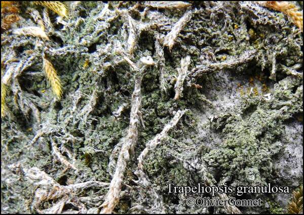
Trapeliopsis granulosa (Hoffm.) Lumbsch
in Hertel, Lecid. Exs., 5: 99, 1983. Basionym: Verrucaria granulosa Hoffm. - Descr. Adumbr. Pl. Crypt. Lich., 2, 1: 21, tab. 30, 1794.
Synonyms: Biatora decolorans auct.; Biatora granulosa (Hoffm.) Flot.; Lecidea decolorans (Hoffm.) Flörke; Lecidea granulosa (Hoffm.) Ach.; Lecidea hilaris Nyl.; Lecidea quadricolor (Dicks.) Borrer; Trapelia granulosa (Hoffm.) V. Wirth
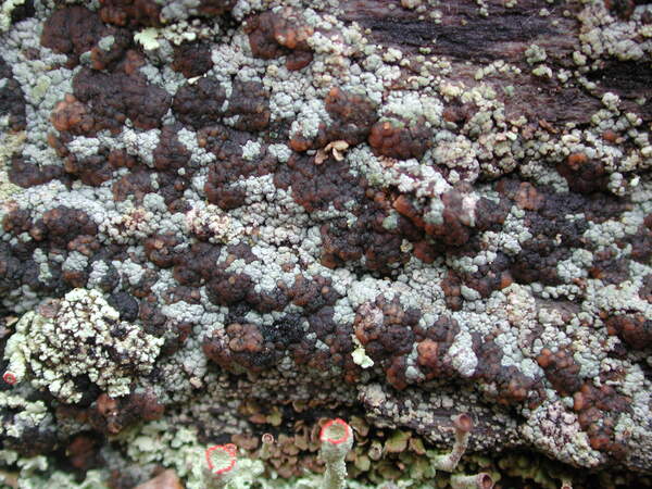
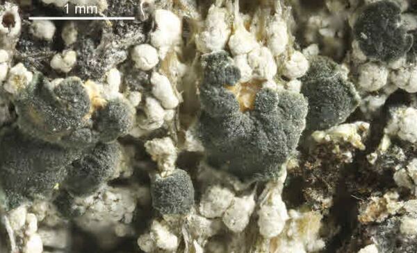
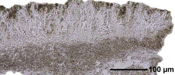
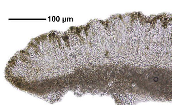
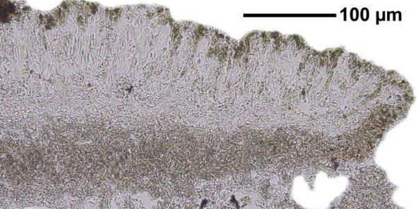
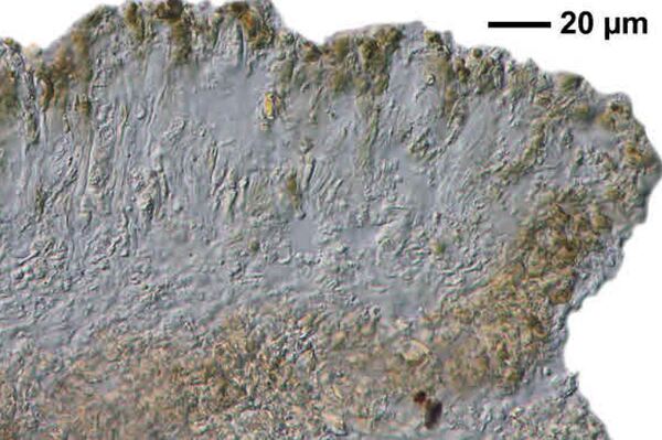
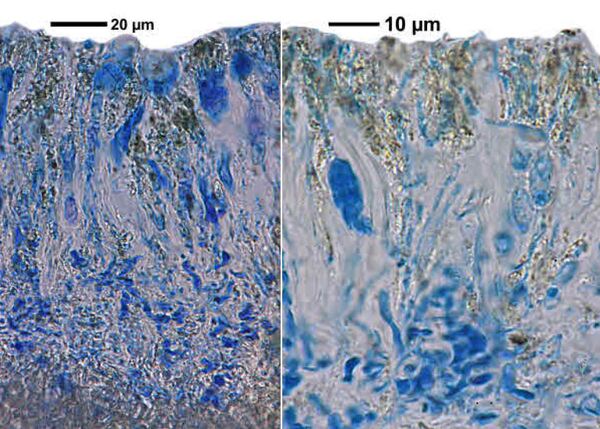
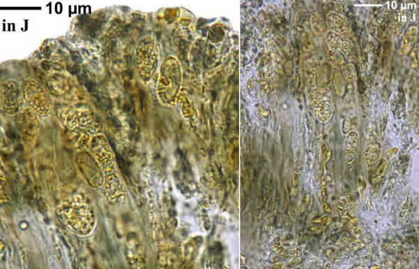
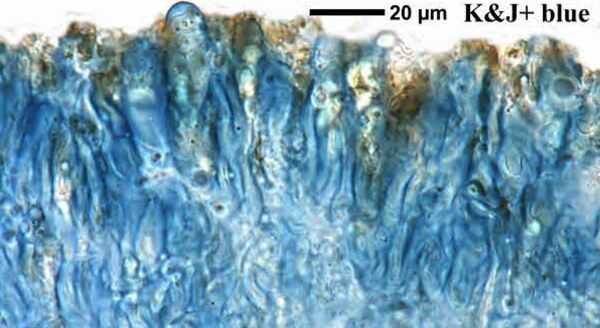
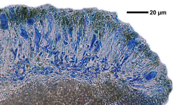
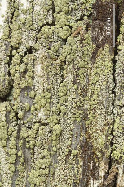
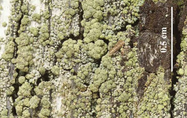
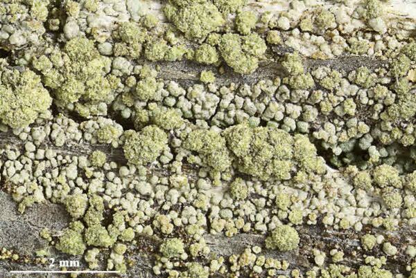
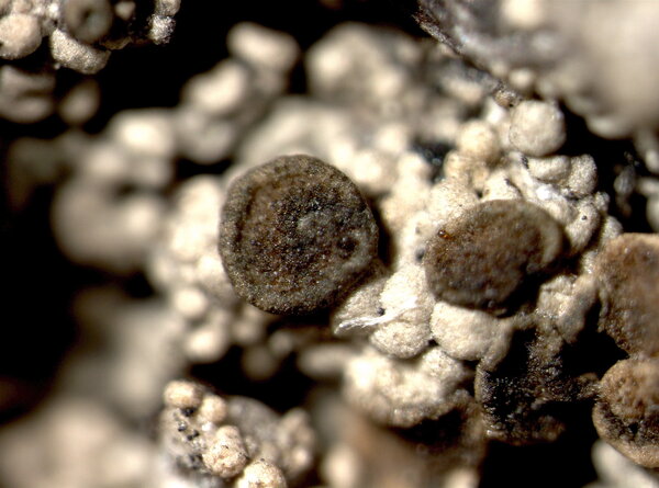
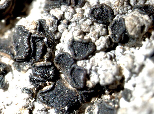
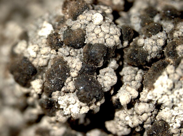
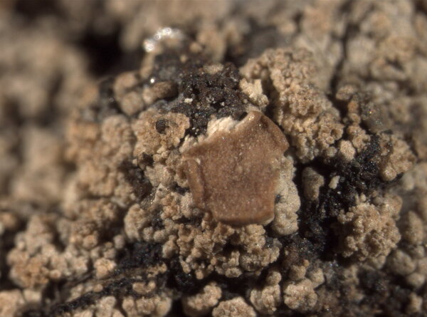
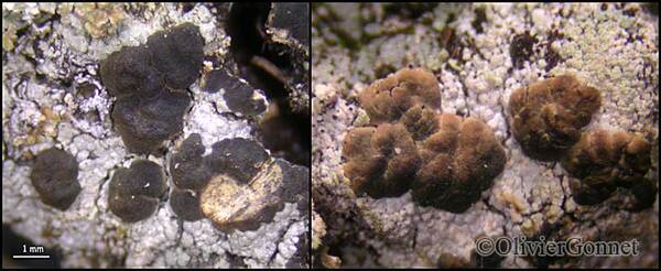
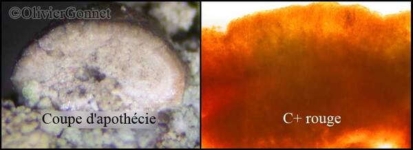
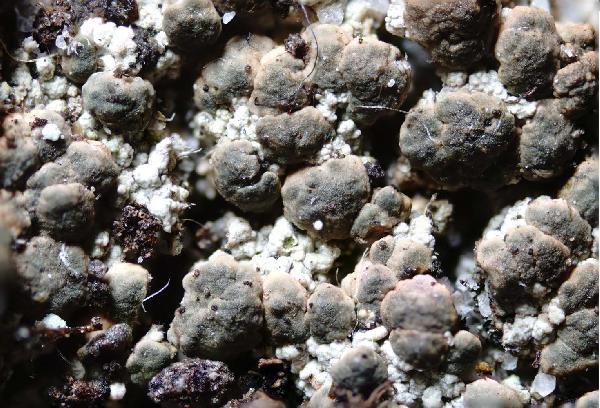
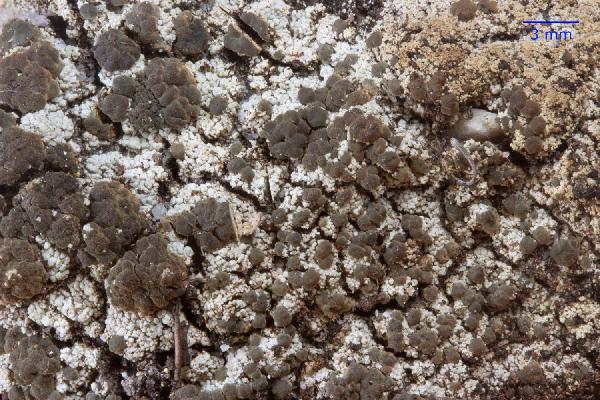
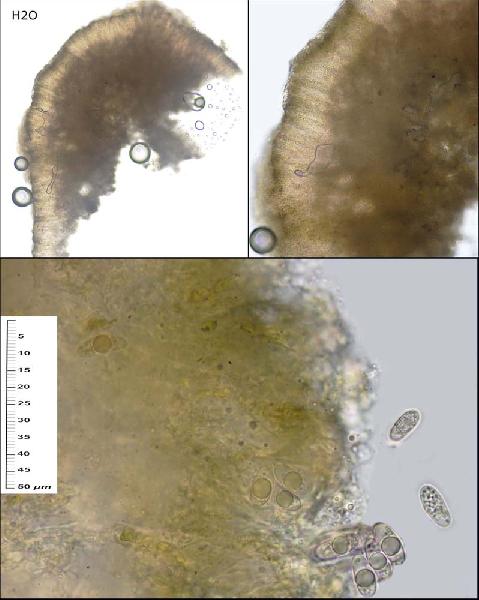
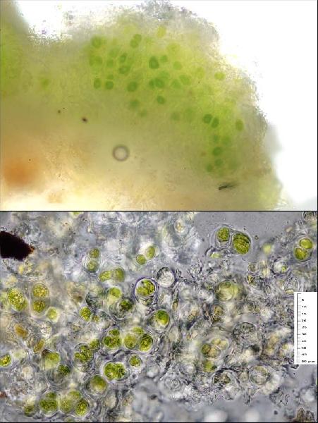
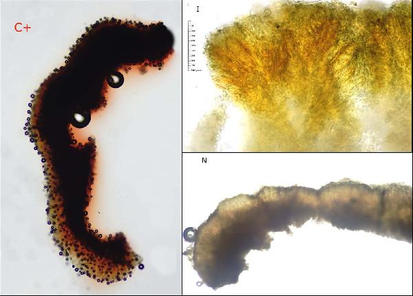
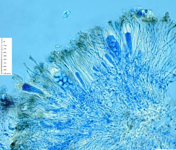
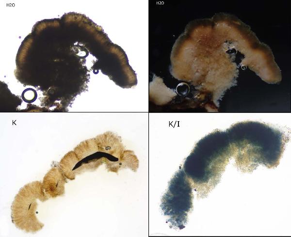
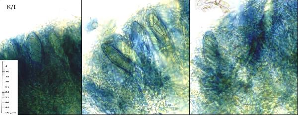
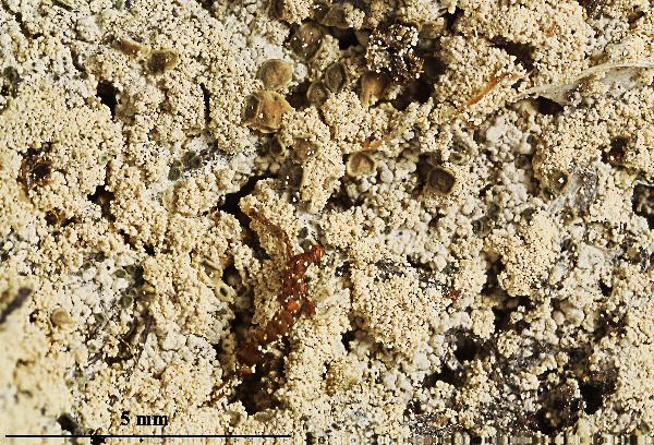
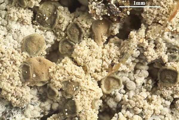
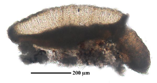
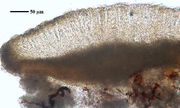
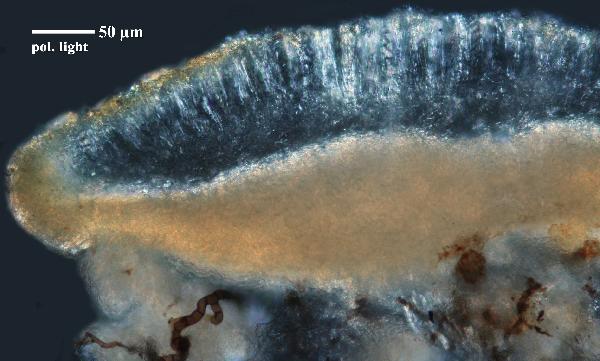
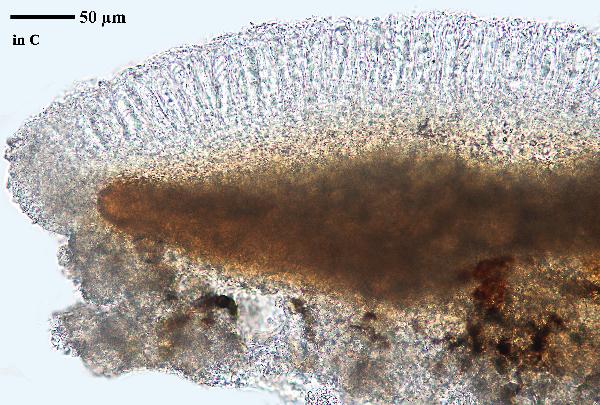
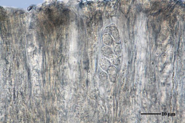
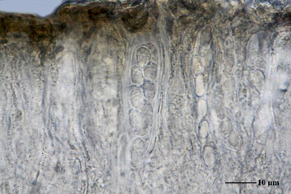
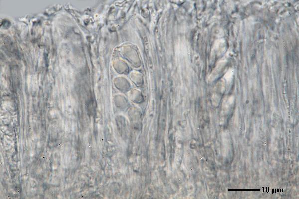
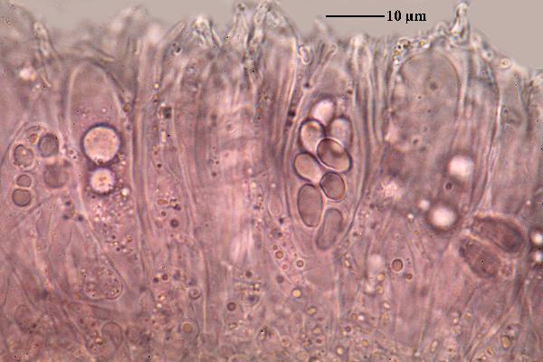
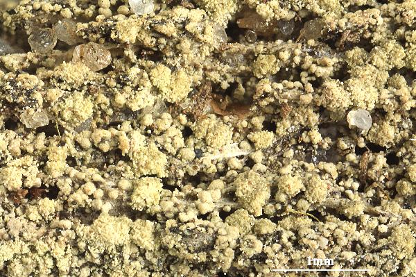
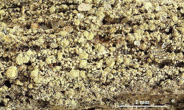
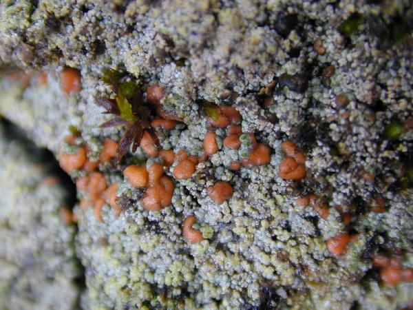
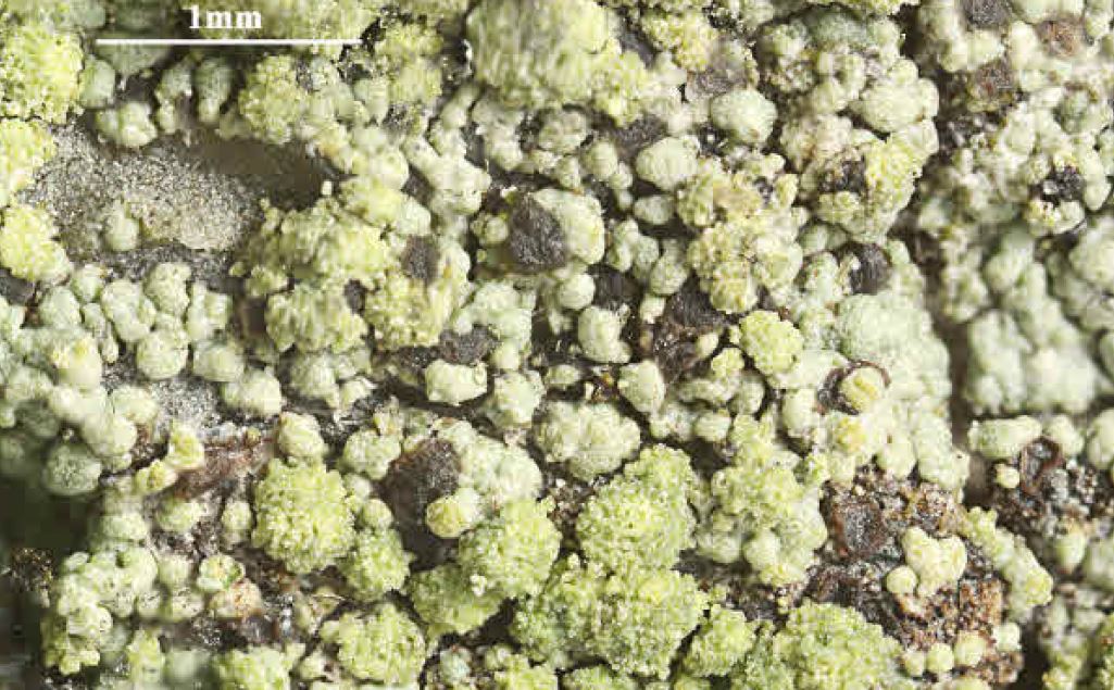
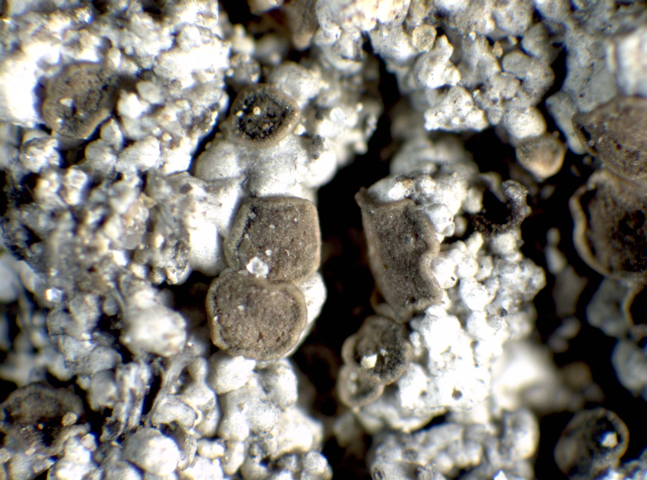
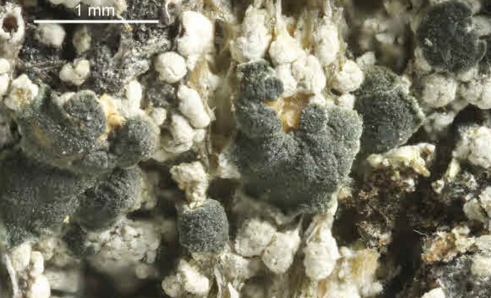
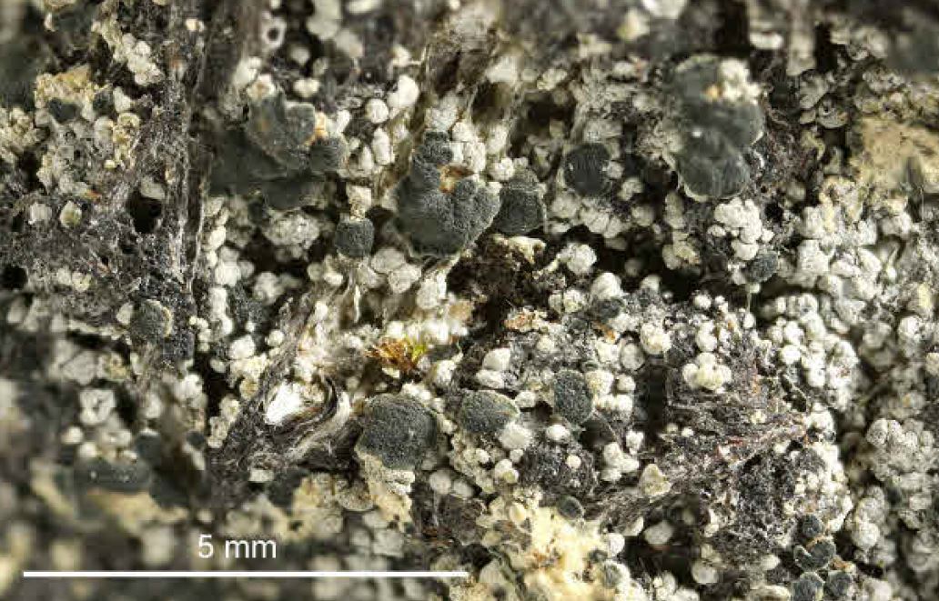
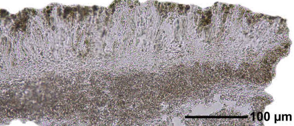
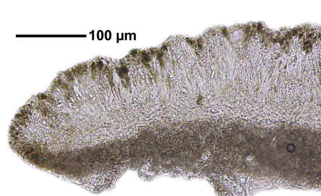
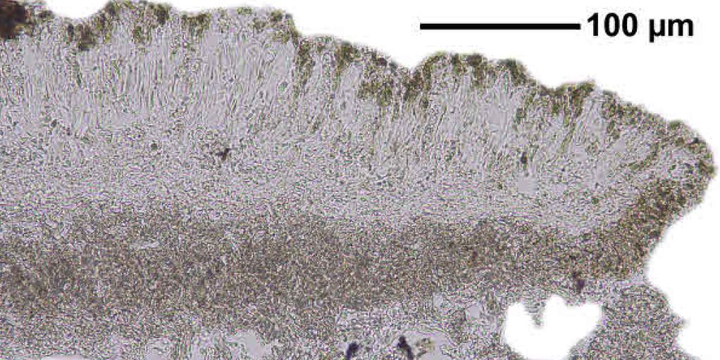
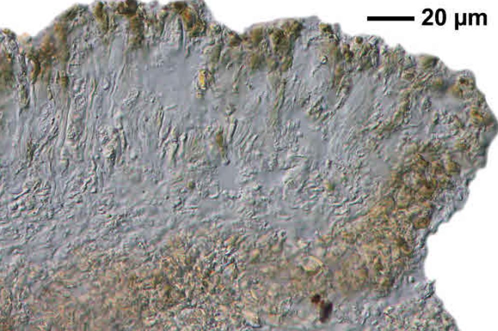
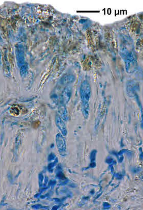
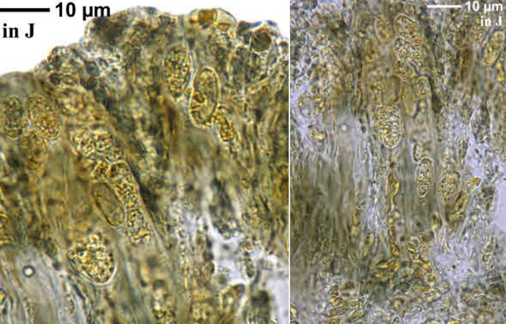
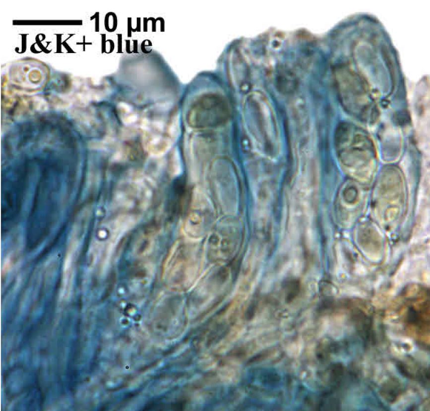
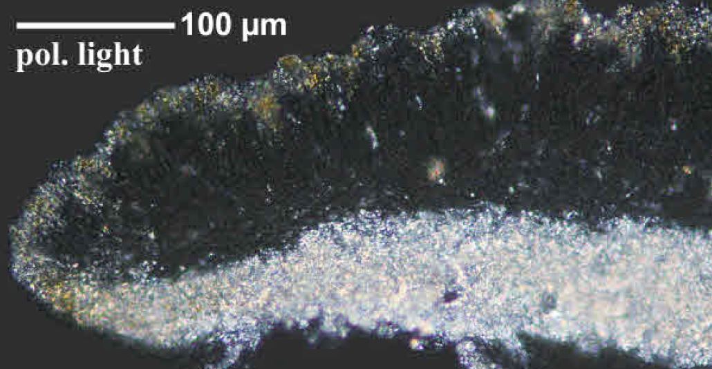
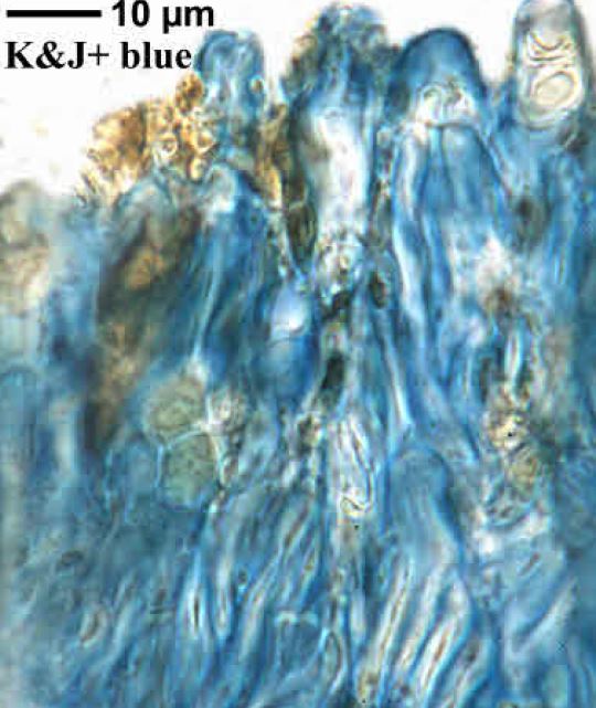
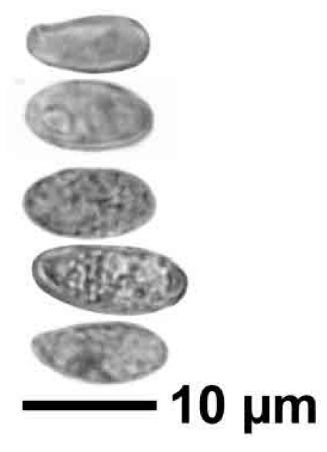
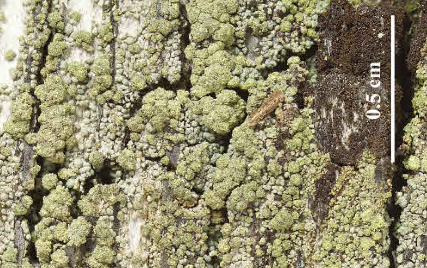
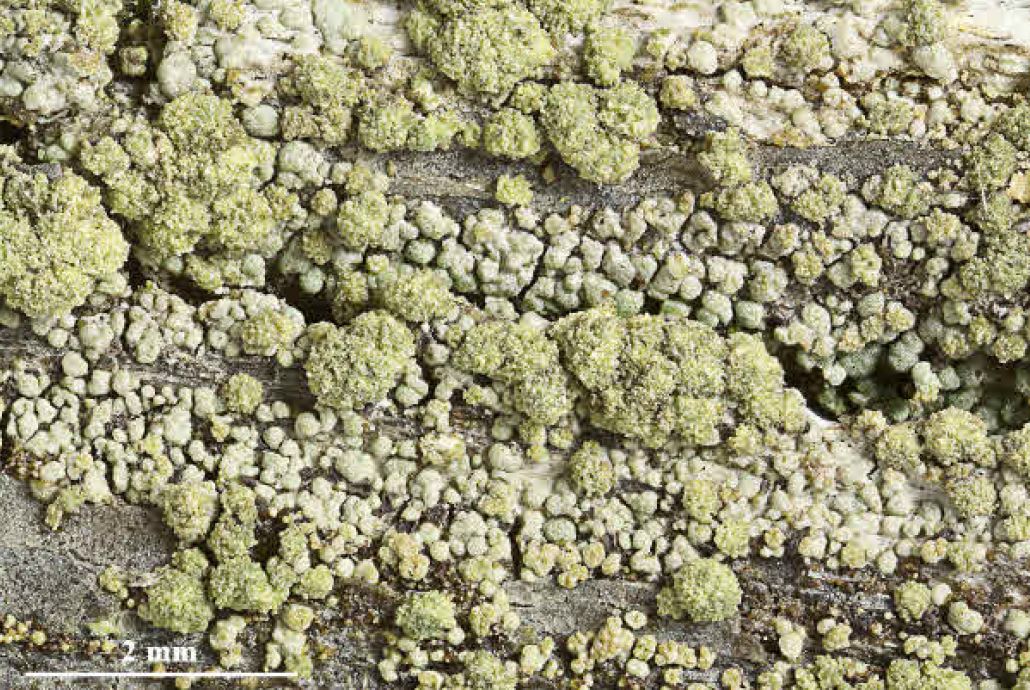
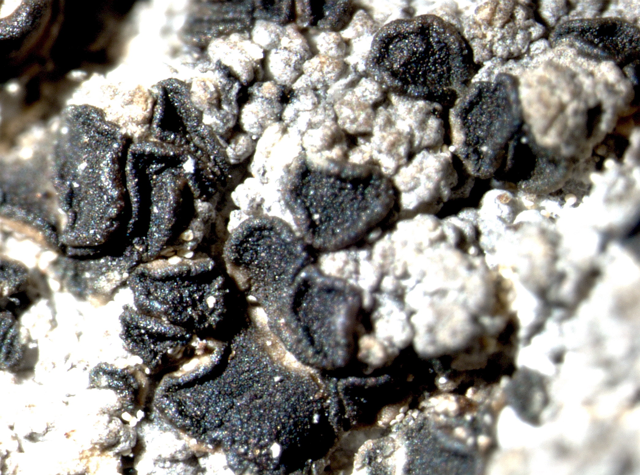
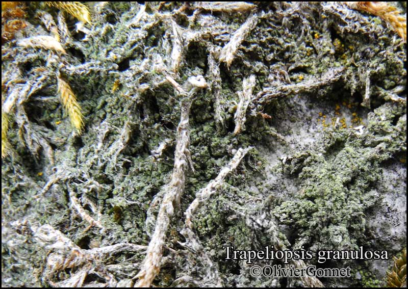
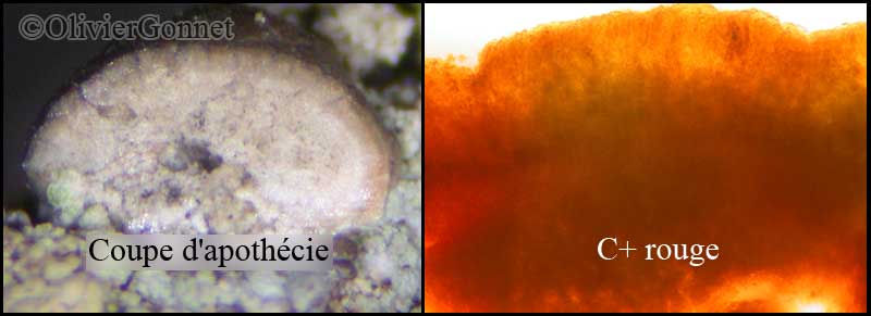
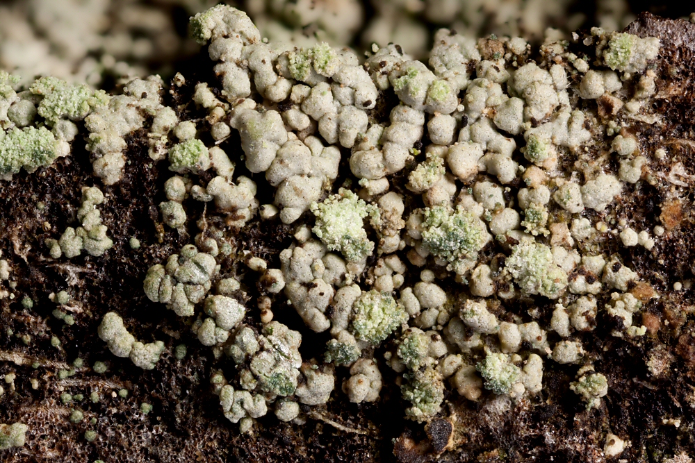
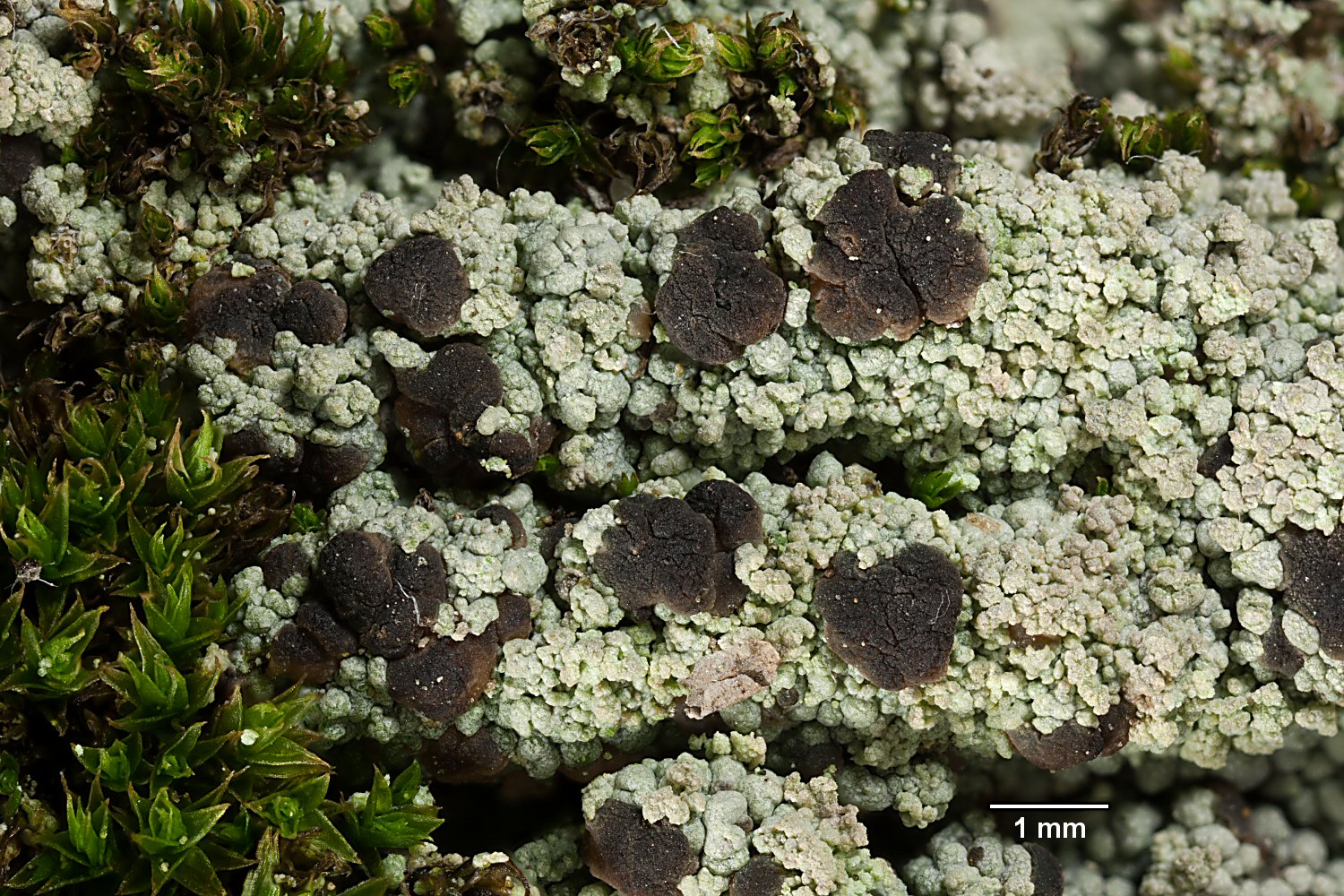
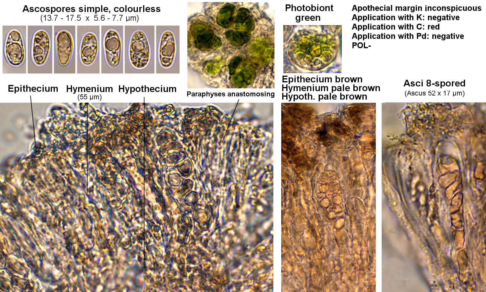
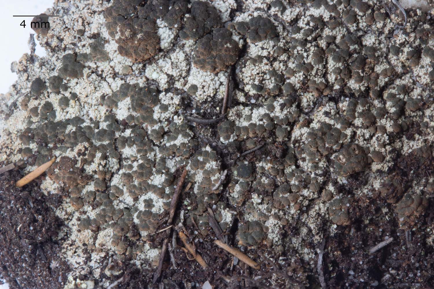
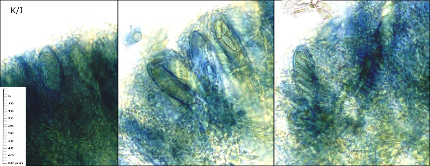
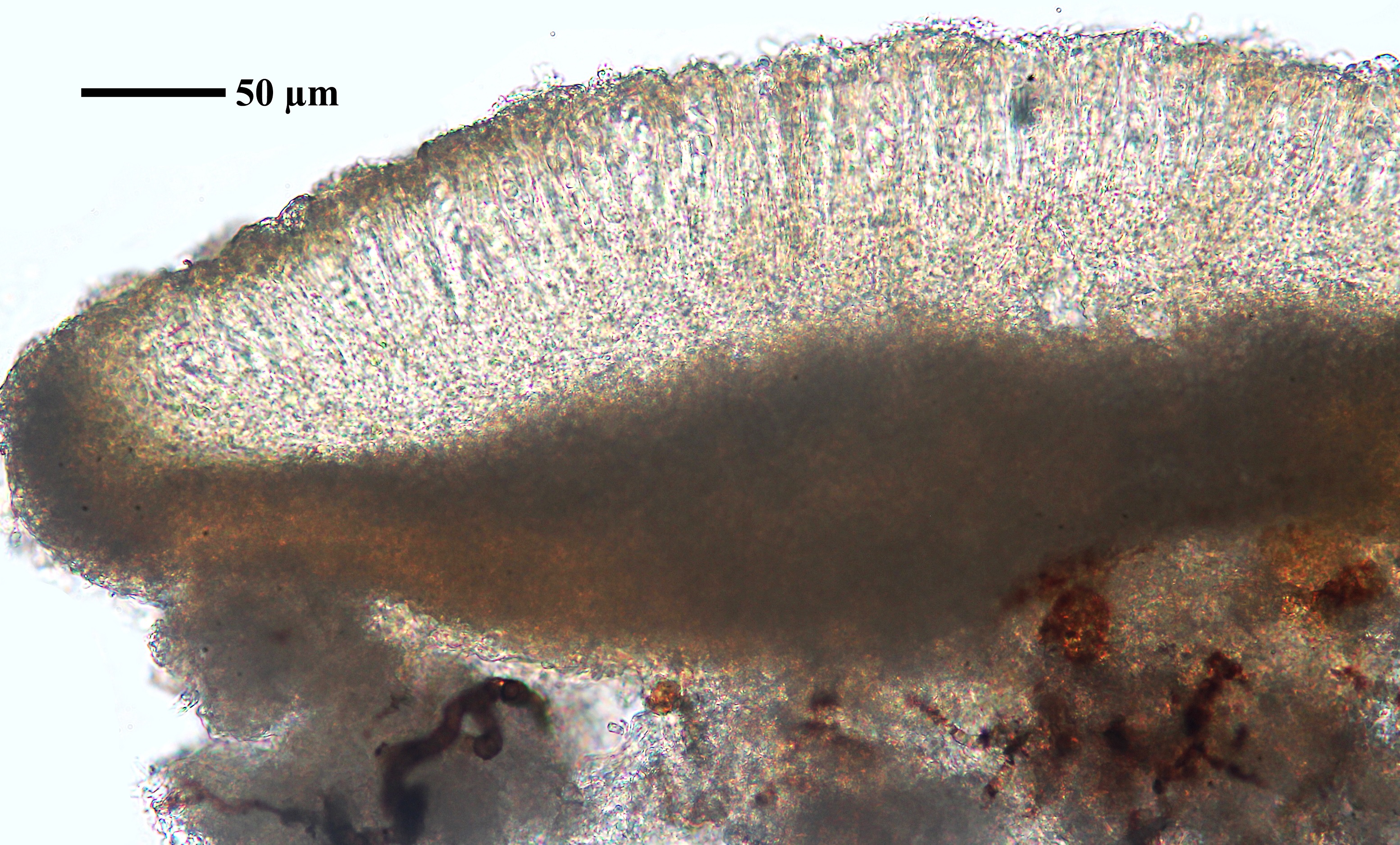
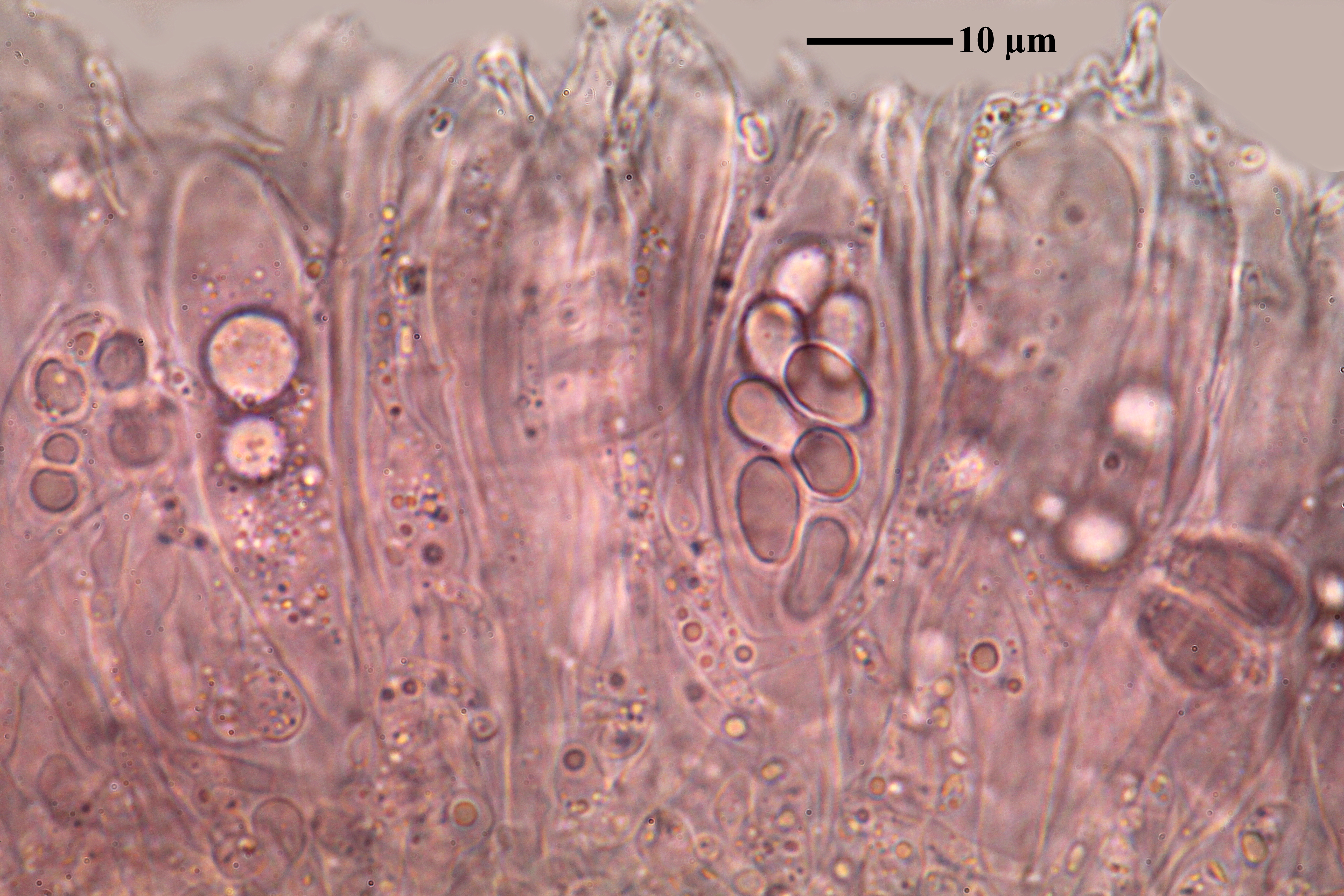
Description: Thallus crustose, episubstratic, whitish, pale grey or rarely pale ochre, thick, areolate, the areoles convex, contiguous, granular to verrucose, to 0.5 mm wide, the marginal ones often somewhat elongate. Soredia diffuse, granular, whitish to brownish yellow or with a faint pinkish hue, sometimes absent. Apothecia frequent, lecideine, sessile, up to 1.5(-1.7) mm across, often of different colours on the same thallus, varying from pale pink, reddish brown, dark grey-green to almost black, with an initially flat, then rapidly convex disc and a thin, flexuose proper margin. Proper exciple grey or colourless in outer part, grey to brown within, of densely entangled hyphae; epithecium pale grey, greenish or pale brown; hymenium colourless or yellowish, 50-80 μm high; paraphyses coherent, 1-2.5 μm thick, slender, branched and anastomosing, only slightly thickened at apex; hypothecium colourless to pale brown. Asci 8-spored, clavate-cylindrical, thin-walled, I+ pale blue, with a small I+ blue cap inside the thickened apex. Ascospores 1-celled, hyaline, ellipsoid, thick-walled, 8-15 x 4-7 μm. Photobiont chlorococcoid. Spot tests: thallus and soredia K-, C+ red, KC+ red, P-, UV+ bluish white. Chemistry: gyrophoric acid.
Growth form: Crustose
Photobiont: green algae other than Trentepohlia
Reproductive strategy: mainly sexual
Commonnes-rarity: (info)
Alpine belt: rather common
Subalpine belt: common
Montane belt: very rare
Dry submediterranean belt: absent
Humid submediterranean belt: absent
Padanian area: absent
pH of the substrata:
1 2 3 4 5

Solar irradiation:
1 2 3 4 5
Aridity:
1 2 3 4 5
Eutrophication:
1 2 3 4 5
Poleotolerance:
0 1 2 3
Altitudinal distribution:
1 2 3 4 5 6
Rarity
absent
extremely rare
very rare
rare
rather rare
rather common
common
very common
extremely common
Loading data...
Occurrence data
Predictive map
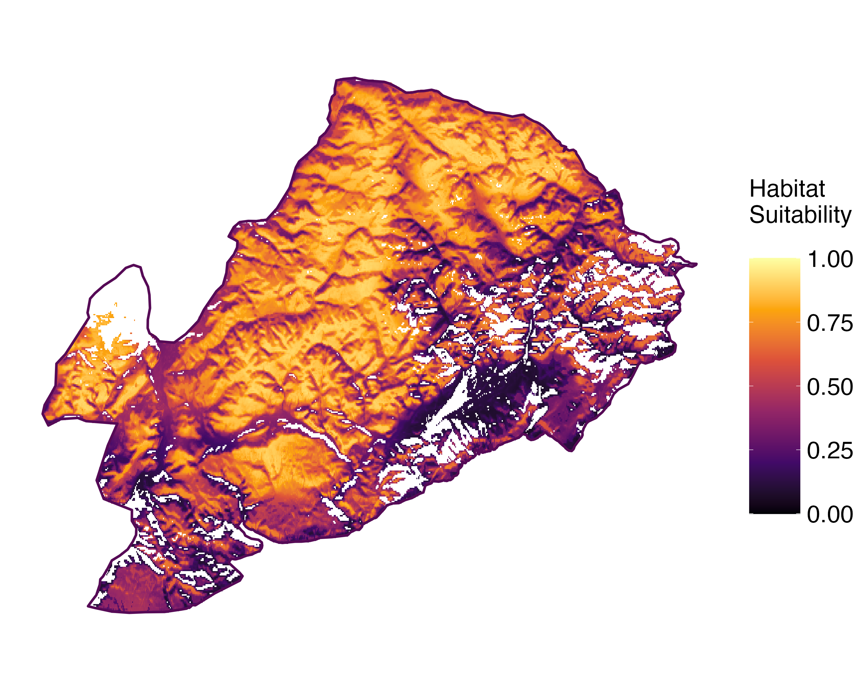 Current prediction (1981-2010)
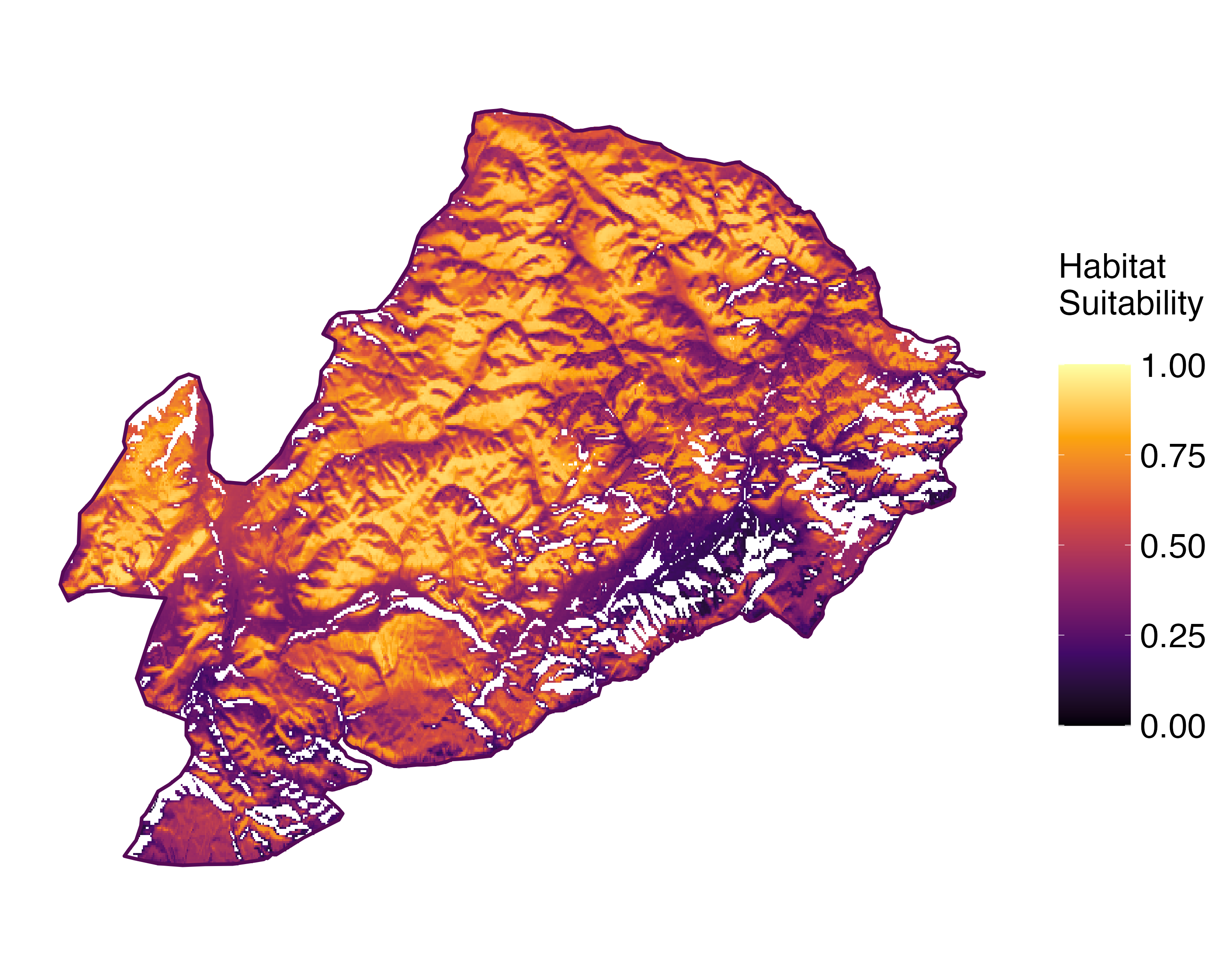 Future prediction (2071-2100) SSP 1-2.6
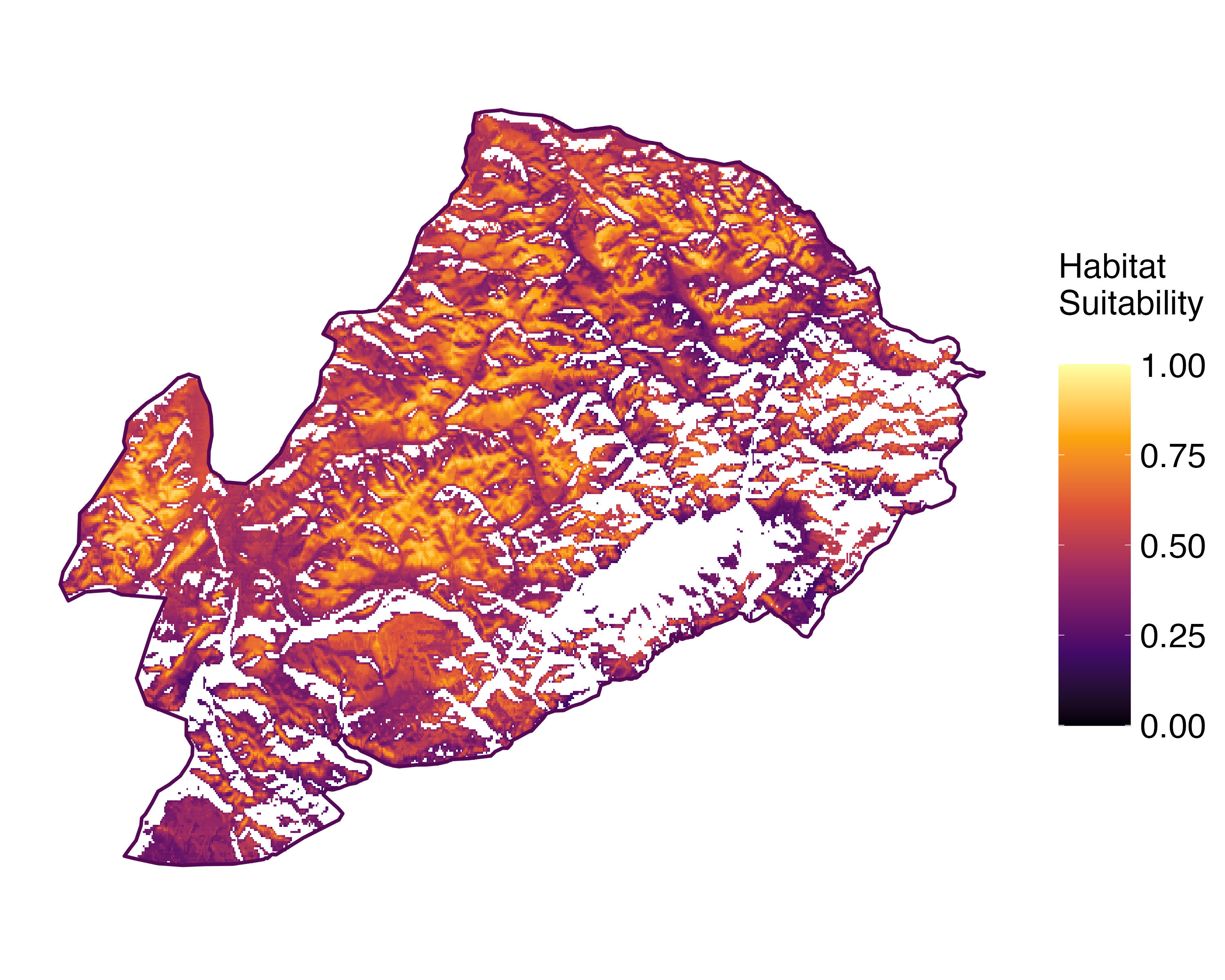 Future prediction (2071-2100) SSP 5-8.5Predictive maps according to Francesconi et al. 2025
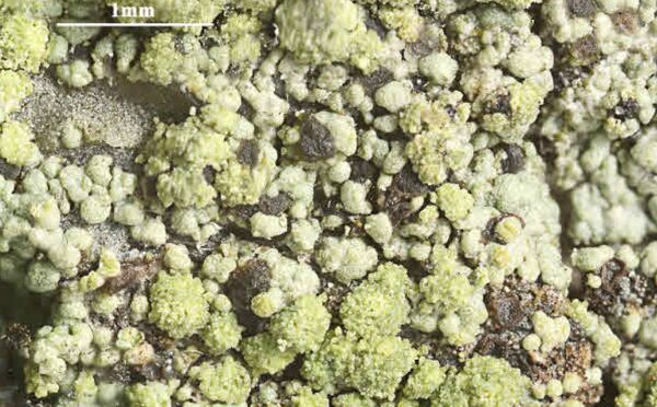
Felix Schumm – CC BY-SA 4.0
[19649], Germany, Baden-Württemberg, Kreis Göppingen, zwischen Wangen und Unterberken, NE vom Parkplatz Rotkreuz, an morschem Holztisch beim Jägerhaus am Buhwiesenweg, 48°45.163' N, 9°35.000' E, 484 m, sonnig. TK 7223. Leg. F. Schumm 29.07.2017, det. F. Schumm 29.07.2017

P.L. Nimis; Owner: Department of Life Sciences, University of Trieste
Herbarium: TSB (14500)
2001/12/01
Juri Nascimbene - CC BY-SA 4.0
Paneveggio, Reg. Trentino-Alto Adige Prov. Trento, Italy.
2009
Felix Schumm – CC BY-SA 4.0
[3060], Schottland, Paß zwischen Applecross und Kishorn, ca. 620 m, auf Rohumus zwischen Erica/Calluna - Polstern, über rotem Sandstein. Leg. Schumm 14.08.1985, det. Schumm 1985, test. Aptroot 2011.

Felix Schumm – CC BY-SA 4.0
[3060], Schottland, Paß zwischen Applecross und Kishorn, ca. 620 m, auf Rohumus zwischen Erica/Calluna - Polstern, über rotem Sandstein. Leg. Schumm 14.08.1985, det. Schumm 1985, test. Aptroot 2011.
Felix Schumm – CC BY-SA 4.0
[3060], Schottland, Paß zwischen Applecross und Kishorn, ca. 620 m, auf Rohumus zwischen Erica/Calluna - Polstern, über rotem Sandstein. Leg. Schumm 14.08.1985, det. Schumm 1985, test. Aptroot 2011.
Felix Schumm – CC BY-SA 4.0
[3060], Schottland, Paß zwischen Applecross und Kishorn, ca. 620 m, auf Rohumus zwischen Erica/Calluna - Polstern, über rotem Sandstein. Leg. Schumm 14.08.1985, det. Schumm 1985, test. Aptroot 2011.
Felix Schumm – CC BY-SA 4.0
[3060], Schottland, Paß zwischen Applecross und Kishorn, ca. 620 m, auf Rohumus zwischen Erica/Calluna - Polstern, über rotem Sandstein. Leg. Schumm 14.08.1985, det. Schumm 1985, test. Aptroot 2011.
Felix Schumm – CC BY-SA 4.0
[3060], Schottland, Paß zwischen Applecross und Kishorn, ca. 620 m, auf Rohumus zwischen Erica/Calluna - Polstern, über rotem Sandstein. Leg. Schumm 14.08.1985, det. Schumm 1985, test. Aptroot 2011.
Felix Schumm – CC BY-SA 4.0
[3060], Schottland, Paß zwischen Applecross und Kishorn, ca. 620 m, auf Rohumus zwischen Erica/Calluna - Polstern, über rotem Sandstein. Leg. Schumm 14.08.1985, det. Schumm 1985, test. Aptroot 2011.

Felix Schumm – CC BY-SA 4.0
[3060], Schottland, Paß zwischen Applecross und Kishorn, ca. 620 m, auf Rohumus zwischen Erica/Calluna - Polstern, über rotem Sandstein. Leg. Schumm 14.08.1985, det. Schumm 1985, test. Aptroot 2011.
Felix Schumm – CC BY-SA 4.0
[3060], Schottland, Paß zwischen Applecross und Kishorn, ca. 620 m, auf Rohumus zwischen Erica/Calluna - Polstern, über rotem Sandstein. Leg. Schumm 14.08.1985, det. Schumm 1985, test. Aptroot 2011.

Felix Schumm – CC BY-SA 4.0
[3060], Schottland, Paß zwischen Applecross und Kishorn, ca. 620 m, auf Rohumus zwischen Erica/Calluna - Polstern, über rotem Sandstein. Leg. Schumm 14.08.1985, det. Schumm 1985, test. Aptroot 2011.

Felix Schumm – CC BY-SA 4.0
[3060], Schottland, Paß zwischen Applecross und Kishorn, ca. 620 m, auf Rohumus zwischen Erica/Calluna - Polstern, über rotem Sandstein. Leg. Schumm 14.08.1985, det. Schumm 1985, test. Aptroot 2011.
Felix Schumm – CC BY-SA 4.0
[3060], Schottland, Paß zwischen Applecross und Kishorn, ca. 620 m, auf Rohumus zwischen Erica/Calluna - Polstern, über rotem Sandstein. Leg. Schumm 14.08.1985, det. Schumm 1985, test. Aptroot 2011.

Felix Schumm – CC BY-SA 4.0
[3060], Schottland, Paß zwischen Applecross und Kishorn, ca. 620 m, auf Rohumus zwischen Erica/Calluna - Polstern, über rotem Sandstein. Leg. Schumm 14.08.1985, det. Schumm 1985, test. Aptroot 2011.
Felix Schumm – CC BY-SA 4.0
[3060], Schottland, Paß zwischen Applecross und Kishorn, ca. 620 m, auf Rohumus zwischen Erica/Calluna - Polstern, über rotem Sandstein. Leg. Schumm 14.08.1985, det. Schumm 1985, test. Aptroot 2011.
Felix Schumm – CC BY-SA 4.0
[19649], Germany, Baden-Württemberg, Kreis Göppingen, zwischen Wangen und Unterberken, NE vom Parkplatz Rotkreuz, an morschem Holztisch beim Jägerhaus am Buhwiesenweg, 48°45.163' N, 9°35.000' E, 484 m, sonnig. TK 7223. Leg. F. Schumm 29.07.2017, det. F. Schumm 29.07.2017

Felix Schumm – CC BY-SA 4.0
[3060], Schottland, Paß zwischen Applecross und Kishorn, ca. 620 m, auf Rohumus zwischen Erica/Calluna - Polstern, über rotem Sandstein. Leg. Schumm 14.08.1985, det. Schumm 1985, test. Aptroot 2011.
Felix Schumm – CC BY-SA 4.0
[19649], Germany, Baden-Württemberg, Kreis Göppingen, zwischen Wangen und Unterberken, NE vom Parkplatz Rotkreuz, an morschem Holztisch beim Jägerhaus am Buhwiesenweg, 48°45.163' N, 9°35.000' E, 484 m, sonnig. TK 7223. Leg. F. Schumm 29.07.2017, det. F. Schumm 29.07.2017
Felix Schumm – CC BY-SA 4.0
[19649], Germany, Baden-Württemberg, Kreis Göppingen, zwischen Wangen und Unterberken, NE vom Parkplatz Rotkreuz, an morschem Holztisch beim Jägerhaus am Buhwiesenweg, 48°45.163' N, 9°35.000' E, 484 m, sonnig. TK 7223. Leg. F. Schumm 29.07.2017, det. F. Schumm 29.07.2017
Pier Luigi Nimis - CC BY-SA 4.0
TSB 14841
Pier Luigi Nimis - CC BY-SA 4.0
TSB 16077
Pier Luigi Nimis - CC BY-SA 4.0
TSB 35648
P.L. Nimis CC BY-SA 4.0
TSB 38072
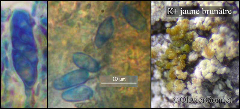
Courtesy Danièle et Olivier Gonnet - Source: https://www.afl-lichenologie.fr/Photos_AFL/Photos_AFL_T/Trapeliopsis_granulosa.htm
France, 29/08/2012 - Col de Balme - Haute-Savoie
Courtesy Danièle et Olivier Gonnet - Source: https://www.afl-lichenologie.fr/Photos_AFL/Photos_AFL_T/Trapeliopsis_granulosa.htm
France, 29/08/2012 - Col de Balme - Haute-Savoie
Courtesy Danièle et Olivier Gonnet - Source: https://www.afl-lichenologie.fr/Photos_AFL/Photos_AFL_T/Trapeliopsis_granulosa.htm
France, 29/08/2012 - Col de Balme - Haute-Savoie

Courtesy Danièle et Olivier Gonnet - Source: https://www.afl-lichenologie.fr/Photos_AFL/Photos_AFL_T/Trapeliopsis_granulosa.htm
France, 29/08/2012 - Col de Balme - Haute-Savoie
Marta González Garcia - Centro de Estudios Micologicos Asturianos
La Farrapona (Somiedo-Asturias), 30-V-2024, en el suelo, junto a escuámulas de Cladonia sp. bajo enebrales rastreros, a 1.800 m de altitud.
Marta González Garcia - Centro de Estudios Micologicos Asturianos
La Farrapona (Somiedo-Asturias), 30-V-2024, en el suelo, junto a escuámulas de Cladonia sp. bajo enebrales rastreros, a 1.800 m de altitud.

Marta González Garcia - Centro de Estudios Micologicos Asturianos
La Farrapona (Somiedo-Asturias), 30-V-2024, en el suelo, junto a escuámulas de Cladonia sp. bajo enebrales rastreros, a 1.800 m de altitud.
Marta González Garcia - Centro de Estudios Micologicos Asturianos
La Farrapona (Somiedo-Asturias), 30-V-2024, en el suelo, junto a escuámulas de Cladonia sp. bajo enebrales rastreros, a 1.800 m de altitud.
Marta González Garcia - Centro de Estudios Micologicos Asturianos
La Farrapona (Somiedo-Asturias), 30-V-2024, en el suelo, junto a escuámulas de Cladonia sp. bajo enebrales rastreros, a 1.800 m de altitud.
Marta González Garcia - Centro de Estudios Micologicos Asturianos
La Farrapona (Somiedo-Asturias), 30-V-2024, en el suelo, junto a escuámulas de Cladonia sp. bajo enebrales rastreros, a 1.800 m de altitud.
Marta González Garcia - Centro de Estudios Micologicos Asturianos
La Farrapona (Somiedo-Asturias), 30-V-2024, en el suelo, junto a escuámulas de Cladonia sp. bajo enebrales rastreros, a 1.800 m de altitud.
Marta González Garcia - Centro de Estudios Micologicos Asturianos
La Farrapona (Somiedo-Asturias), 30-V-2024, en el suelo, junto a escuámulas de Cladonia sp. bajo enebrales rastreros, a 1.800 m de altitud.
Marta González Garcia - Centro de Estudios Micologicos Asturianos
La Farrapona (Somiedo-Asturias), 30-V-2024, en el suelo, junto a escuámulas de Cladonia sp. bajo enebrales rastreros, a 1.800 m de altitud.
Felix Schumm - CC BY-SA 4.0
[21105], Schweiz, Wallis, Champex westl. Orsières, Val de Arpette,
Granituntergrund, ca. 1700 m. SVBL-Exkursion. Leg. F. Schumm,
22.08.1996, det. F. Schumm.
Felix Schumm - CC BY-SA 4.0
[21105], Schweiz, Wallis, Champex westl. Orsières, Val de Arpette,
Granituntergrund, ca. 1700 m. SVBL-Exkursion. Leg. F. Schumm,
22.08.1996, det. F. Schumm.
Felix Schumm - CC BY-SA 4.0
[21105], Schweiz, Wallis, Champex westl. Orsières, Val de Arpette,
Granituntergrund, ca. 1700 m. SVBL-Exkursion. Leg. F. Schumm,
22.08.1996, det. F. Schumm.
Felix Schumm - CC BY-SA 4.0
[21105], Schweiz, Wallis, Champex westl. Orsières, Val de Arpette,
Granituntergrund, ca. 1700 m. SVBL-Exkursion. Leg. F. Schumm,
22.08.1996, det. F. Schumm.
Felix Schumm - CC BY-SA 4.0
[21105], Schweiz, Wallis, Champex westl. Orsières, Val de Arpette,
Granituntergrund, ca. 1700 m. SVBL-Exkursion. Leg. F. Schumm,
22.08.1996, det. F. Schumm.
Felix Schumm - CC BY-SA 4.0
[21105], Schweiz, Wallis, Champex westl. Orsières, Val de Arpette,
Granituntergrund, ca. 1700 m. SVBL-Exkursion. Leg. F. Schumm,
22.08.1996, det. F. Schumm.
Felix Schumm - CC BY-SA 4.0
[21105], Schweiz, Wallis, Champex westl. Orsières, Val de Arpette,
Granituntergrund, ca. 1700 m. SVBL-Exkursion. Leg. F. Schumm,
22.08.1996, det. F. Schumm.
Felix Schumm - CC BY-SA 4.0
[21105], Schweiz, Wallis, Champex westl. Orsières, Val de Arpette,
Granituntergrund, ca. 1700 m. SVBL-Exkursion. Leg. F. Schumm,
22.08.1996, det. F. Schumm.
Felix Schumm - CC BY-SA 4.0
[21105], Schweiz, Wallis, Champex westl. Orsières, Val de Arpette,
Granituntergrund, ca. 1700 m. SVBL-Exkursion. Leg. F. Schumm,
22.08.1996, det. F. Schumm.
Felix Schumm - CC BY-SA 4.0
[21105], Schweiz, Wallis, Champex westl. Orsières, Val de Arpette,
Granituntergrund, ca. 1700 m. SVBL-Exkursion. Leg. F. Schumm,
22.08.1996, det. F. Schumm.
Felix Schumm - CC BY-SA 4.0
[ABL27849], Brazil, Santa Catarina, São Francisco do Sul, Parque
Estadual do Acaraí. 26°19'14'' S, 48°33'13'' W, 10 m. In restinga vegetation
on wood. Leg. M. Cáceres & A. Aptroot (no 27849), 7 October
2015, det. A. Aptroot 2015.
Felix Schumm - CC BY-SA 4.0
[ABL27849], Brazil, Santa Catarina, São Francisco do Sul, Parque
Estadual do Acaraí. 26°19'14'' S, 48°33'13'' W, 10 m. In restinga vegetation
on wood. Leg. M. Cáceres & A. Aptroot (no 27849), 7 October
2015, det. A. Aptroot 2015.
Wolfgang von Brackel - CC BY-4.0
Czech Republic, Krkonosce

Wolfgang von Brackel - CC BY-4.0
Germany, Bavaria, Arber

Wolfgang von Brackel - CC BY-4.0
Germany, Bavaria, Lohberger Riegel-Nord

Wolfgang von Brackel - CC BY-4.0
Germany, Bavaria, Plöckenstein 2019

Collezione lichenologica Abramo Massalongo del Museo di Storia Naturale G. Ligabue di Venezia - Autori: Seggi, Linda; Trabucco, Raffaella Proprietà: Fondazione Musei Civici di Venezia - CC BY-NC
Italy, Trentino-Alto Adige, Trento, in Campobruno 1855
as Biatora decolorans
Growth form: Crustose
Photobiont: green algae other than Trentepohlia
Reproductive strategy: mainly sexual
Commonnes-rarity: (info)
Alpine belt: rather common
Subalpine belt: common
Montane belt: very rare
Dry submediterranean belt: absent
Humid submediterranean belt: absent
Padanian area: absent
pH of the substrata:
| 1 | 2 | 3 | 4 | 5 |
Solar irradiation:
| 1 | 2 | 3 | 4 | 5 |
Aridity:
| 1 | 2 | 3 | 4 | 5 |
Eutrophication:
| 1 | 2 | 3 | 4 | 5 |
Poleotolerance:
| 0 | 1 | 2 | 3 |
Altitudinal distribution:
| 1 | 2 | 3 | 4 | 5 | 6 |
Rarity
absent
extremely rare
very rare
rare
rather rare
rather common
common
very common
extremely common
Loading data...
Occurrence data
Predictive map
Current prediction (1981-2010)Future prediction (2071-2100) SSP 1-2.6Future prediction (2071-2100) SSP 5-8.5Predictive maps according to Francesconi et al. 2025
Felix Schumm – CC BY-SA 4.0
[19649], Germany, Baden-Württemberg, Kreis Göppingen, zwischen Wangen und Unterberken, NE vom Parkplatz Rotkreuz, an morschem Holztisch beim Jägerhaus am Buhwiesenweg, 48°45.163' N, 9°35.000' E, 484 m, sonnig. TK 7223. Leg. F. Schumm 29.07.2017, det. F. Schumm 29.07.2017
P.L. Nimis; Owner: Department of Life Sciences, University of Trieste
Herbarium: TSB (14500)
2001/12/01

Juri Nascimbene - CC BY-SA 4.0
Paneveggio, Reg. Trentino-Alto Adige Prov. Trento, Italy.
2009
Felix Schumm – CC BY-SA 4.0
[3060], Schottland, Paß zwischen Applecross und Kishorn, ca. 620 m, auf Rohumus zwischen Erica/Calluna - Polstern, über rotem Sandstein. Leg. Schumm 14.08.1985, det. Schumm 1985, test. Aptroot 2011.
Felix Schumm – CC BY-SA 4.0
[3060], Schottland, Paß zwischen Applecross und Kishorn, ca. 620 m, auf Rohumus zwischen Erica/Calluna - Polstern, über rotem Sandstein. Leg. Schumm 14.08.1985, det. Schumm 1985, test. Aptroot 2011.
Felix Schumm – CC BY-SA 4.0
[3060], Schottland, Paß zwischen Applecross und Kishorn, ca. 620 m, auf Rohumus zwischen Erica/Calluna - Polstern, über rotem Sandstein. Leg. Schumm 14.08.1985, det. Schumm 1985, test. Aptroot 2011.
Felix Schumm – CC BY-SA 4.0
[3060], Schottland, Paß zwischen Applecross und Kishorn, ca. 620 m, auf Rohumus zwischen Erica/Calluna - Polstern, über rotem Sandstein. Leg. Schumm 14.08.1985, det. Schumm 1985, test. Aptroot 2011.
Felix Schumm – CC BY-SA 4.0
[3060], Schottland, Paß zwischen Applecross und Kishorn, ca. 620 m, auf Rohumus zwischen Erica/Calluna - Polstern, über rotem Sandstein. Leg. Schumm 14.08.1985, det. Schumm 1985, test. Aptroot 2011.
Felix Schumm – CC BY-SA 4.0
[3060], Schottland, Paß zwischen Applecross und Kishorn, ca. 620 m, auf Rohumus zwischen Erica/Calluna - Polstern, über rotem Sandstein. Leg. Schumm 14.08.1985, det. Schumm 1985, test. Aptroot 2011.

Felix Schumm – CC BY-SA 4.0
[3060], Schottland, Paß zwischen Applecross und Kishorn, ca. 620 m, auf Rohumus zwischen Erica/Calluna - Polstern, über rotem Sandstein. Leg. Schumm 14.08.1985, det. Schumm 1985, test. Aptroot 2011.
Felix Schumm – CC BY-SA 4.0
[3060], Schottland, Paß zwischen Applecross und Kishorn, ca. 620 m, auf Rohumus zwischen Erica/Calluna - Polstern, über rotem Sandstein. Leg. Schumm 14.08.1985, det. Schumm 1985, test. Aptroot 2011.
Felix Schumm – CC BY-SA 4.0
[3060], Schottland, Paß zwischen Applecross und Kishorn, ca. 620 m, auf Rohumus zwischen Erica/Calluna - Polstern, über rotem Sandstein. Leg. Schumm 14.08.1985, det. Schumm 1985, test. Aptroot 2011.
Felix Schumm – CC BY-SA 4.0
[3060], Schottland, Paß zwischen Applecross und Kishorn, ca. 620 m, auf Rohumus zwischen Erica/Calluna - Polstern, über rotem Sandstein. Leg. Schumm 14.08.1985, det. Schumm 1985, test. Aptroot 2011.
Felix Schumm – CC BY-SA 4.0
[3060], Schottland, Paß zwischen Applecross und Kishorn, ca. 620 m, auf Rohumus zwischen Erica/Calluna - Polstern, über rotem Sandstein. Leg. Schumm 14.08.1985, det. Schumm 1985, test. Aptroot 2011.

Felix Schumm – CC BY-SA 4.0
[3060], Schottland, Paß zwischen Applecross und Kishorn, ca. 620 m, auf Rohumus zwischen Erica/Calluna - Polstern, über rotem Sandstein. Leg. Schumm 14.08.1985, det. Schumm 1985, test. Aptroot 2011.
Felix Schumm – CC BY-SA 4.0
[3060], Schottland, Paß zwischen Applecross und Kishorn, ca. 620 m, auf Rohumus zwischen Erica/Calluna - Polstern, über rotem Sandstein. Leg. Schumm 14.08.1985, det. Schumm 1985, test. Aptroot 2011.

Felix Schumm – CC BY-SA 4.0
[3060], Schottland, Paß zwischen Applecross und Kishorn, ca. 620 m, auf Rohumus zwischen Erica/Calluna - Polstern, über rotem Sandstein. Leg. Schumm 14.08.1985, det. Schumm 1985, test. Aptroot 2011.

Felix Schumm – CC BY-SA 4.0
[19649], Germany, Baden-Württemberg, Kreis Göppingen, zwischen Wangen und Unterberken, NE vom Parkplatz Rotkreuz, an morschem Holztisch beim Jägerhaus am Buhwiesenweg, 48°45.163' N, 9°35.000' E, 484 m, sonnig. TK 7223. Leg. F. Schumm 29.07.2017, det. F. Schumm 29.07.2017
Felix Schumm – CC BY-SA 4.0
[3060], Schottland, Paß zwischen Applecross und Kishorn, ca. 620 m, auf Rohumus zwischen Erica/Calluna - Polstern, über rotem Sandstein. Leg. Schumm 14.08.1985, det. Schumm 1985, test. Aptroot 2011.
Felix Schumm – CC BY-SA 4.0
[19649], Germany, Baden-Württemberg, Kreis Göppingen, zwischen Wangen und Unterberken, NE vom Parkplatz Rotkreuz, an morschem Holztisch beim Jägerhaus am Buhwiesenweg, 48°45.163' N, 9°35.000' E, 484 m, sonnig. TK 7223. Leg. F. Schumm 29.07.2017, det. F. Schumm 29.07.2017
Felix Schumm – CC BY-SA 4.0
[19649], Germany, Baden-Württemberg, Kreis Göppingen, zwischen Wangen und Unterberken, NE vom Parkplatz Rotkreuz, an morschem Holztisch beim Jägerhaus am Buhwiesenweg, 48°45.163' N, 9°35.000' E, 484 m, sonnig. TK 7223. Leg. F. Schumm 29.07.2017, det. F. Schumm 29.07.2017

Pier Luigi Nimis - CC BY-SA 4.0
TSB 14841
Pier Luigi Nimis - CC BY-SA 4.0
TSB 16077

Pier Luigi Nimis - CC BY-SA 4.0
TSB 35648

P.L. Nimis CC BY-SA 4.0
TSB 38072
Courtesy Danièle et Olivier Gonnet - Source: https://www.afl-lichenologie.fr/Photos_AFL/Photos_AFL_T/Trapeliopsis_granulosa.htm
France, 29/08/2012 - Col de Balme - Haute-Savoie

Courtesy Danièle et Olivier Gonnet - Source: https://www.afl-lichenologie.fr/Photos_AFL/Photos_AFL_T/Trapeliopsis_granulosa.htm
France, 29/08/2012 - Col de Balme - Haute-Savoie
Courtesy Danièle et Olivier Gonnet - Source: https://www.afl-lichenologie.fr/Photos_AFL/Photos_AFL_T/Trapeliopsis_granulosa.htm
France, 29/08/2012 - Col de Balme - Haute-Savoie
Courtesy Danièle et Olivier Gonnet - Source: https://www.afl-lichenologie.fr/Photos_AFL/Photos_AFL_T/Trapeliopsis_granulosa.htm
France, 29/08/2012 - Col de Balme - Haute-Savoie

Marta González Garcia - Centro de Estudios Micologicos Asturianos
La Farrapona (Somiedo-Asturias), 30-V-2024, en el suelo, junto a escuámulas de Cladonia sp. bajo enebrales rastreros, a 1.800 m de altitud.

Marta González Garcia - Centro de Estudios Micologicos Asturianos
La Farrapona (Somiedo-Asturias), 30-V-2024, en el suelo, junto a escuámulas de Cladonia sp. bajo enebrales rastreros, a 1.800 m de altitud.
Marta González Garcia - Centro de Estudios Micologicos Asturianos
La Farrapona (Somiedo-Asturias), 30-V-2024, en el suelo, junto a escuámulas de Cladonia sp. bajo enebrales rastreros, a 1.800 m de altitud.

Marta González Garcia - Centro de Estudios Micologicos Asturianos
La Farrapona (Somiedo-Asturias), 30-V-2024, en el suelo, junto a escuámulas de Cladonia sp. bajo enebrales rastreros, a 1.800 m de altitud.

Marta González Garcia - Centro de Estudios Micologicos Asturianos
La Farrapona (Somiedo-Asturias), 30-V-2024, en el suelo, junto a escuámulas de Cladonia sp. bajo enebrales rastreros, a 1.800 m de altitud.

Marta González Garcia - Centro de Estudios Micologicos Asturianos
La Farrapona (Somiedo-Asturias), 30-V-2024, en el suelo, junto a escuámulas de Cladonia sp. bajo enebrales rastreros, a 1.800 m de altitud.

Marta González Garcia - Centro de Estudios Micologicos Asturianos
La Farrapona (Somiedo-Asturias), 30-V-2024, en el suelo, junto a escuámulas de Cladonia sp. bajo enebrales rastreros, a 1.800 m de altitud.

Marta González Garcia - Centro de Estudios Micologicos Asturianos
La Farrapona (Somiedo-Asturias), 30-V-2024, en el suelo, junto a escuámulas de Cladonia sp. bajo enebrales rastreros, a 1.800 m de altitud.
Marta González Garcia - Centro de Estudios Micologicos Asturianos
La Farrapona (Somiedo-Asturias), 30-V-2024, en el suelo, junto a escuámulas de Cladonia sp. bajo enebrales rastreros, a 1.800 m de altitud.

Felix Schumm - CC BY-SA 4.0
[21105], Schweiz, Wallis, Champex westl. Orsières, Val de Arpette, Granituntergrund, ca. 1700 m. SVBL-Exkursion. Leg. F. Schumm, 22.08.1996, det. F. Schumm.

Felix Schumm - CC BY-SA 4.0
[21105], Schweiz, Wallis, Champex westl. Orsières, Val de Arpette, Granituntergrund, ca. 1700 m. SVBL-Exkursion. Leg. F. Schumm, 22.08.1996, det. F. Schumm.

Felix Schumm - CC BY-SA 4.0
[21105], Schweiz, Wallis, Champex westl. Orsières, Val de Arpette, Granituntergrund, ca. 1700 m. SVBL-Exkursion. Leg. F. Schumm, 22.08.1996, det. F. Schumm.
Felix Schumm - CC BY-SA 4.0
[21105], Schweiz, Wallis, Champex westl. Orsières, Val de Arpette, Granituntergrund, ca. 1700 m. SVBL-Exkursion. Leg. F. Schumm, 22.08.1996, det. F. Schumm.

Felix Schumm - CC BY-SA 4.0
[21105], Schweiz, Wallis, Champex westl. Orsières, Val de Arpette, Granituntergrund, ca. 1700 m. SVBL-Exkursion. Leg. F. Schumm, 22.08.1996, det. F. Schumm.

Felix Schumm - CC BY-SA 4.0
[21105], Schweiz, Wallis, Champex westl. Orsières, Val de Arpette, Granituntergrund, ca. 1700 m. SVBL-Exkursion. Leg. F. Schumm, 22.08.1996, det. F. Schumm.

Felix Schumm - CC BY-SA 4.0
[21105], Schweiz, Wallis, Champex westl. Orsières, Val de Arpette, Granituntergrund, ca. 1700 m. SVBL-Exkursion. Leg. F. Schumm, 22.08.1996, det. F. Schumm.

Felix Schumm - CC BY-SA 4.0
[21105], Schweiz, Wallis, Champex westl. Orsières, Val de Arpette, Granituntergrund, ca. 1700 m. SVBL-Exkursion. Leg. F. Schumm, 22.08.1996, det. F. Schumm.

Felix Schumm - CC BY-SA 4.0
[21105], Schweiz, Wallis, Champex westl. Orsières, Val de Arpette, Granituntergrund, ca. 1700 m. SVBL-Exkursion. Leg. F. Schumm, 22.08.1996, det. F. Schumm.
Felix Schumm - CC BY-SA 4.0
[21105], Schweiz, Wallis, Champex westl. Orsières, Val de Arpette, Granituntergrund, ca. 1700 m. SVBL-Exkursion. Leg. F. Schumm, 22.08.1996, det. F. Schumm.

Felix Schumm - CC BY-SA 4.0
[ABL27849], Brazil, Santa Catarina, São Francisco do Sul, Parque Estadual do Acaraí. 26°19'14'' S, 48°33'13'' W, 10 m. In restinga vegetation on wood. Leg. M. Cáceres & A. Aptroot (no 27849), 7 October 2015, det. A. Aptroot 2015.

Felix Schumm - CC BY-SA 4.0
[ABL27849], Brazil, Santa Catarina, São Francisco do Sul, Parque Estadual do Acaraí. 26°19'14'' S, 48°33'13'' W, 10 m. In restinga vegetation on wood. Leg. M. Cáceres & A. Aptroot (no 27849), 7 October 2015, det. A. Aptroot 2015.

Wolfgang von Brackel - CC BY-4.0
Czech Republic, Krkonosce

Wolfgang von Brackel - CC BY-4.0
Germany, Bavaria, Arber

Wolfgang von Brackel - CC BY-4.0
Germany, Bavaria, Lohberger Riegel-Nord

Wolfgang von Brackel - CC BY-4.0
Germany, Bavaria, Plöckenstein 2019


