Alyxoria varia (Pers.) Ertz & Tehler
Fungal Divers., 49: 53, 2011. Basionym: Opegrapha varia Pers. - Ann. Bot. (Usteri), 1: 30, 1794.
Synonyms: Opegrapha chlorina Pers.; Opegrapha cymbiformis Flörke; Opegrapha diaphora Ach.; Opegrapha lichenoides Pers.; Opegrapha lichenoides var. chlorina (Pers.) Redinger; Opegrapha lichenoides var. nigrocaesia Chevall.; Opegrapha maroccana Müll. Arg.; Opegrapha pitardi var. viridans Maheu & Werner; Opegrapha pollinii A. Massal.; Opegrapha pulicaris auct. p.p. non Pers. ex Fr.; Opegrapha rimalis Pers.; Opegrapha signata (Ach.) Ach.; Opegrapha varia f. subericola Jatta; Opegrapha varia var. confluens A. Massal.; Opegrapha varia var. diaphora (Ach.) Fr.; Opegrapha varia var. fagicola A. Massal.; Opegrapha varia var. juglandis A. Massal.; Opegrapha violatra A. Massal.; Opegrapha vulvella Ach.
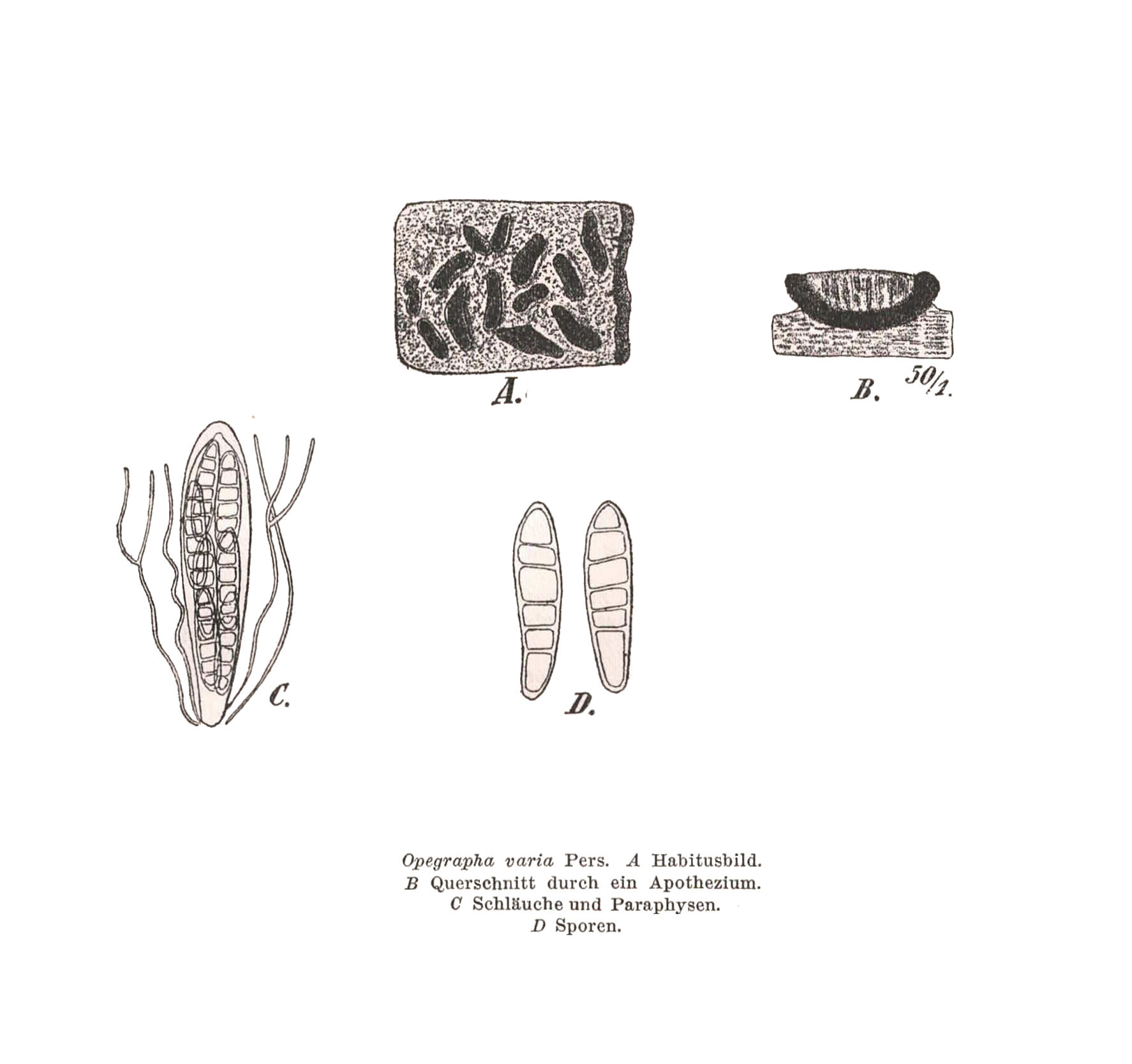
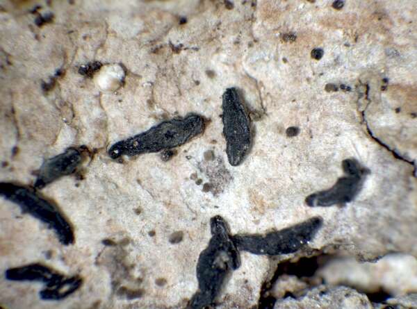
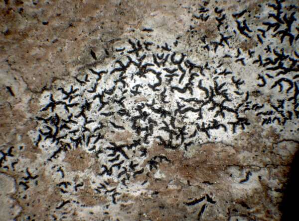
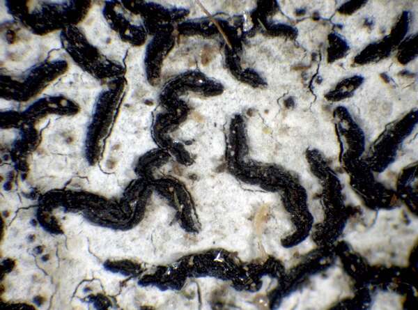
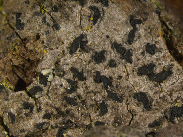
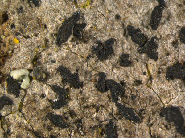
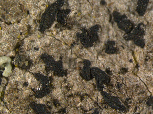
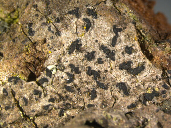
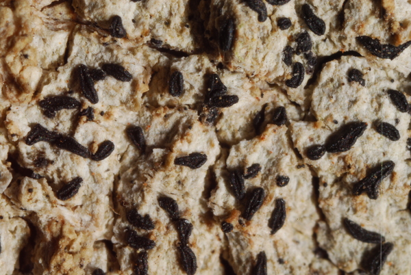
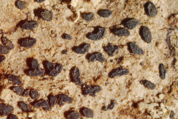
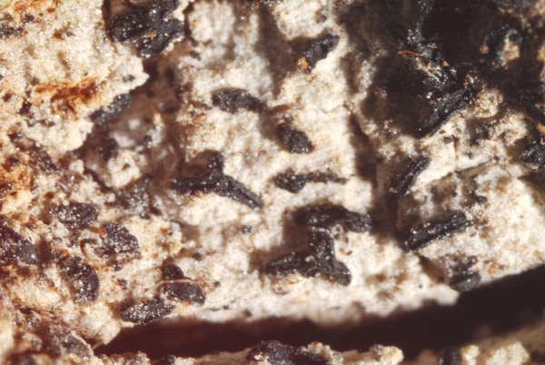
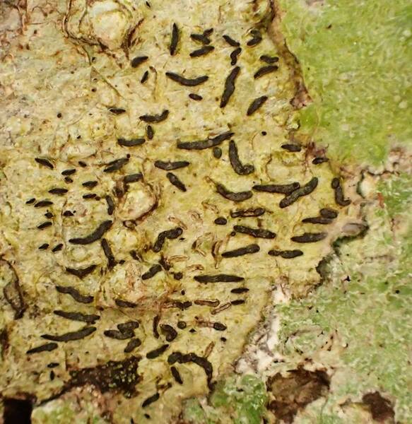
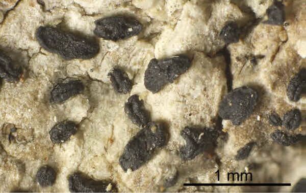
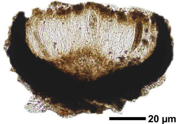
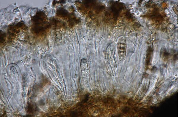
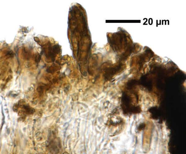
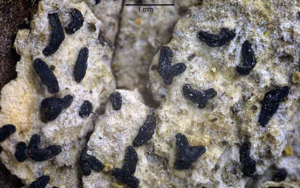
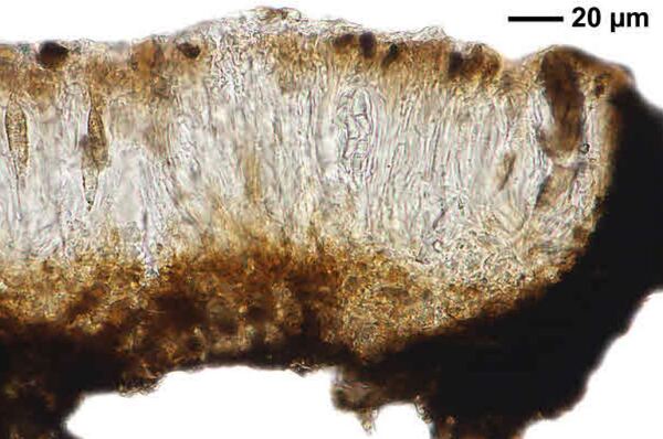
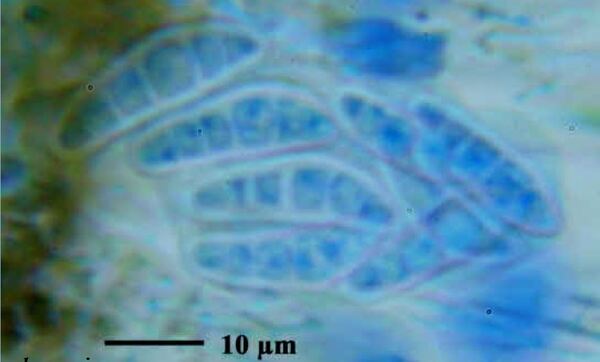
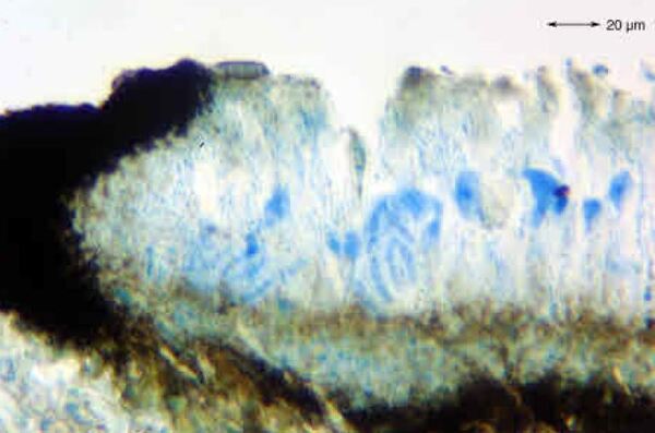
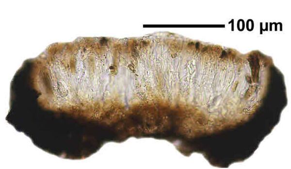
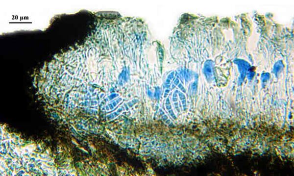
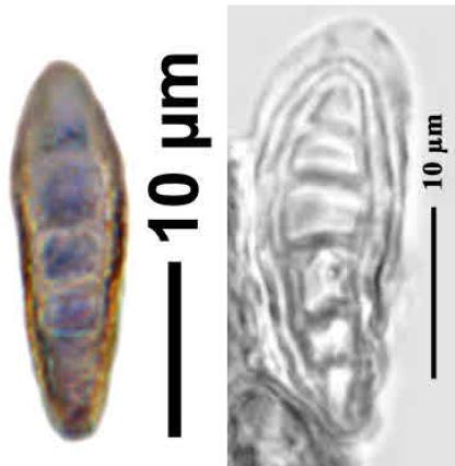
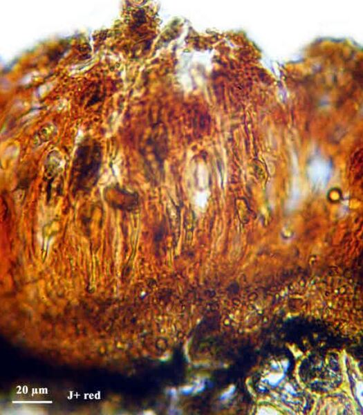
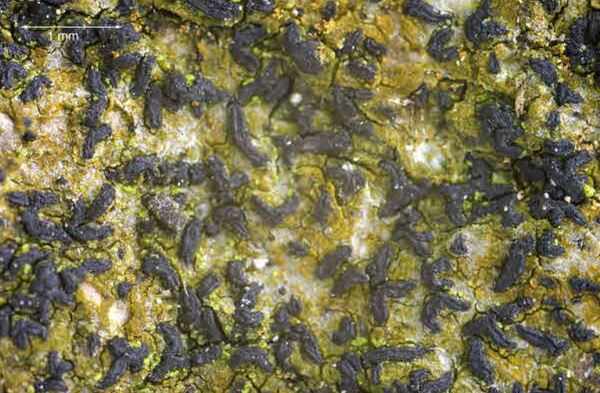
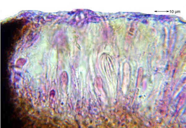
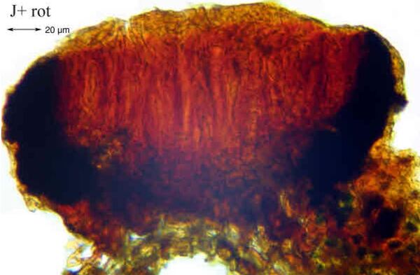
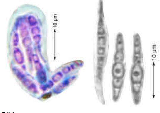
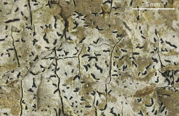
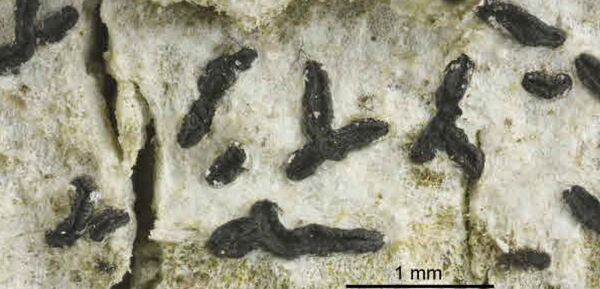
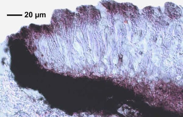
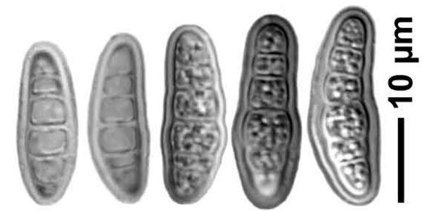
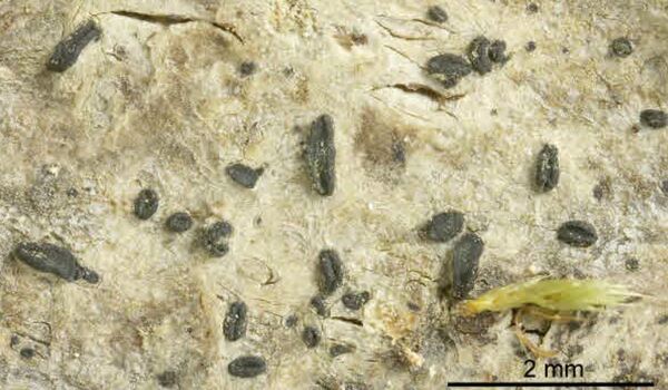
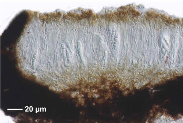
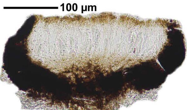
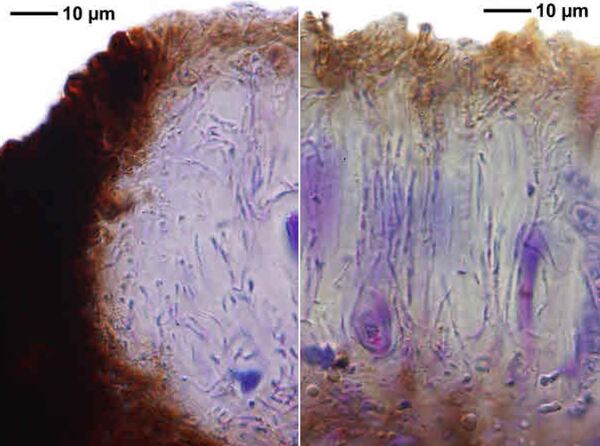
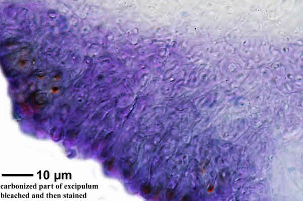
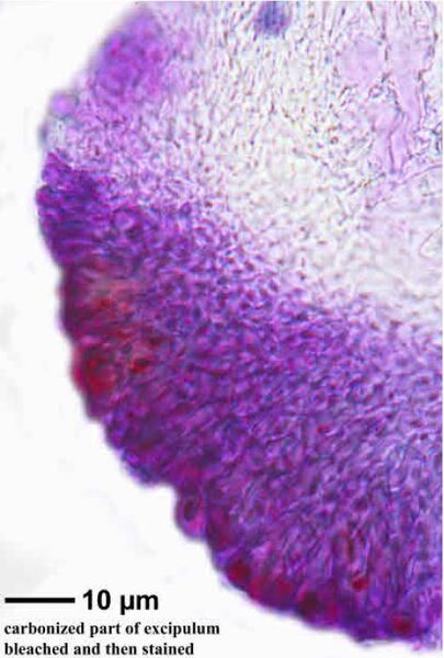
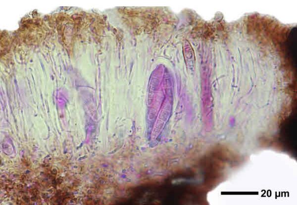
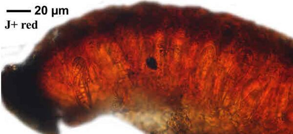
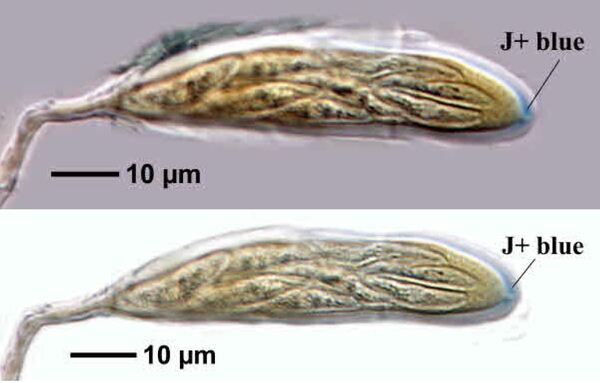
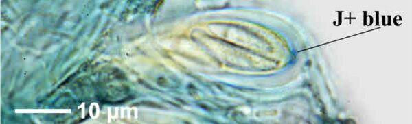
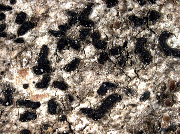
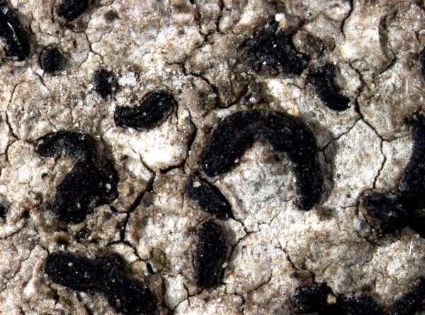
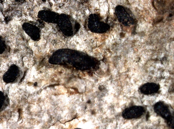
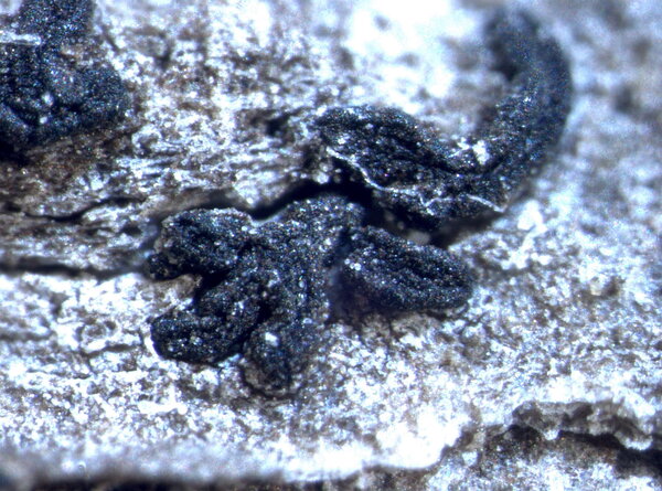
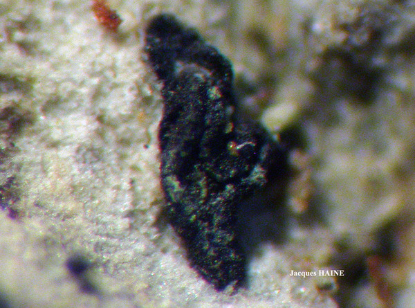
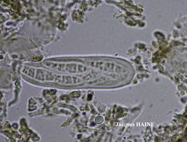
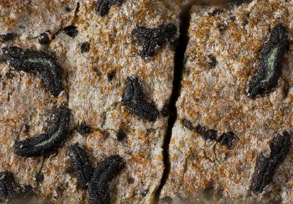
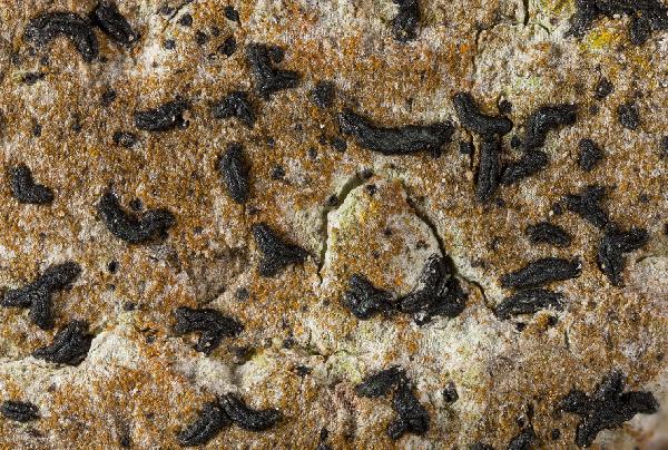
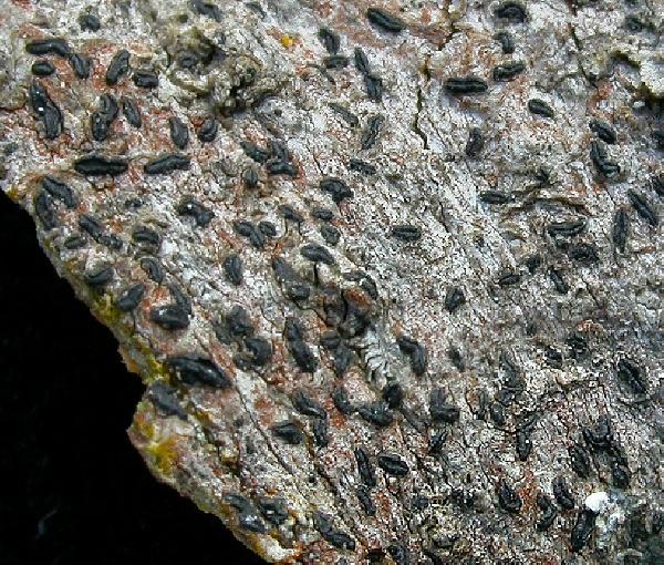
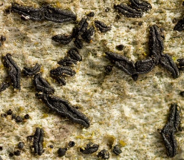
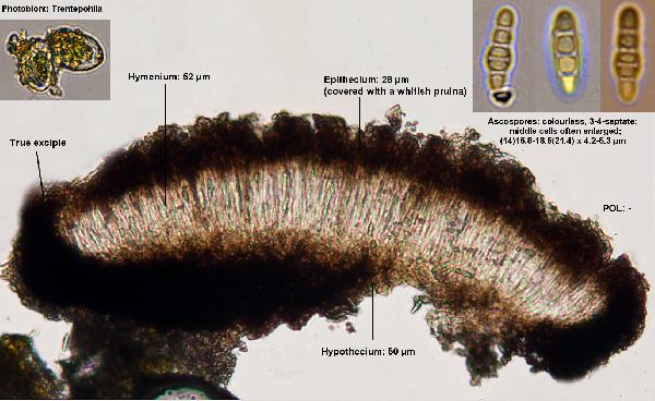
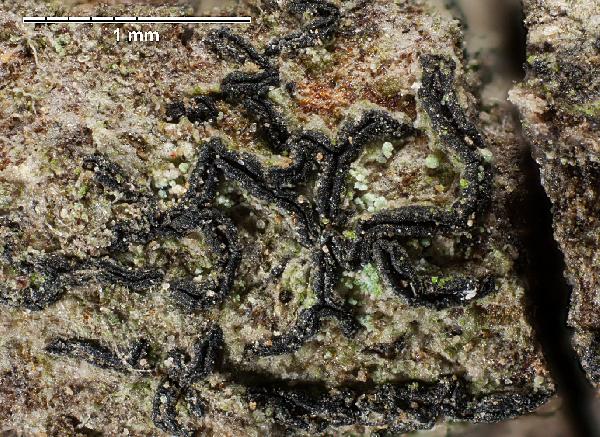
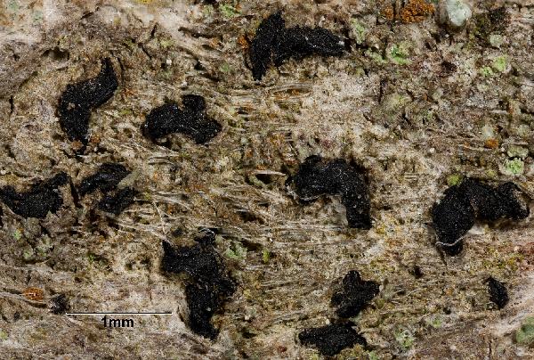
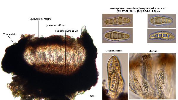
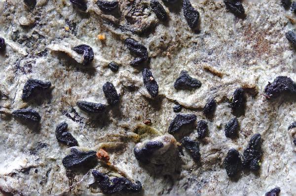
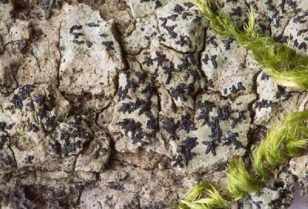
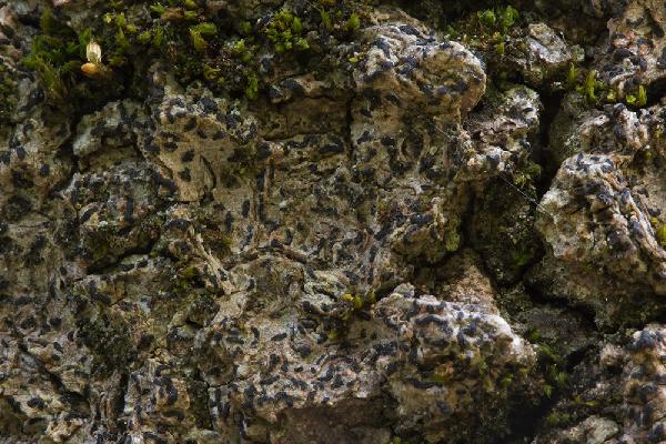
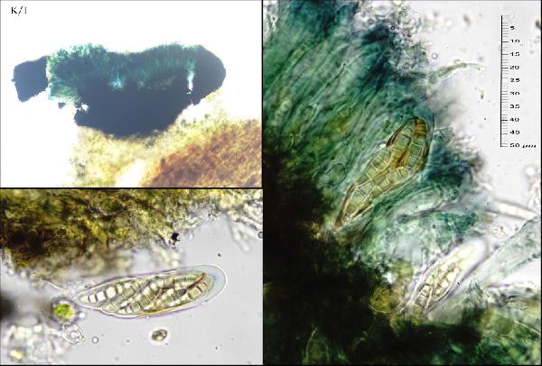
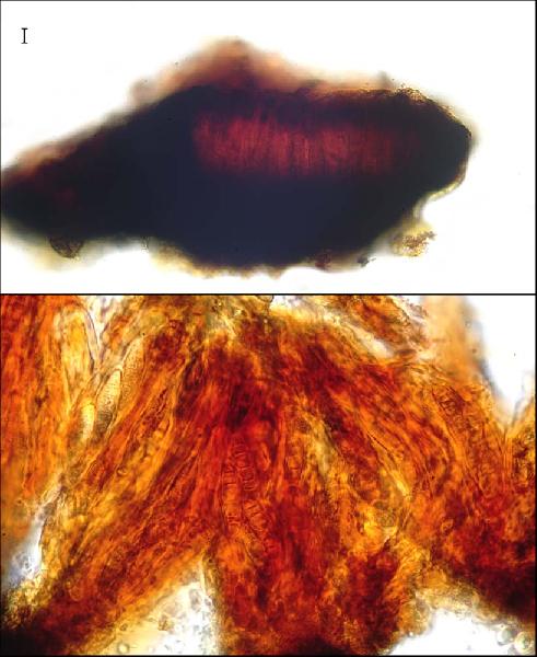
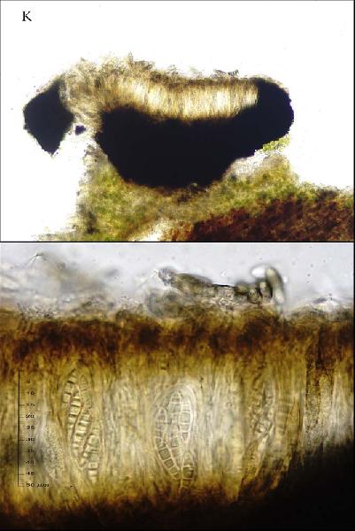
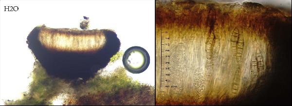
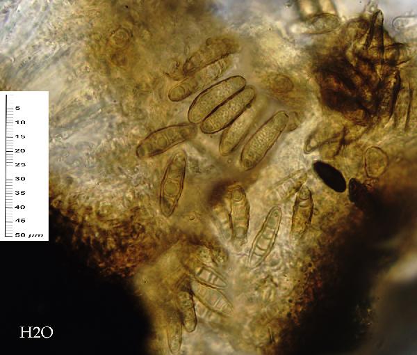
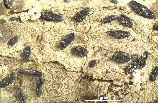
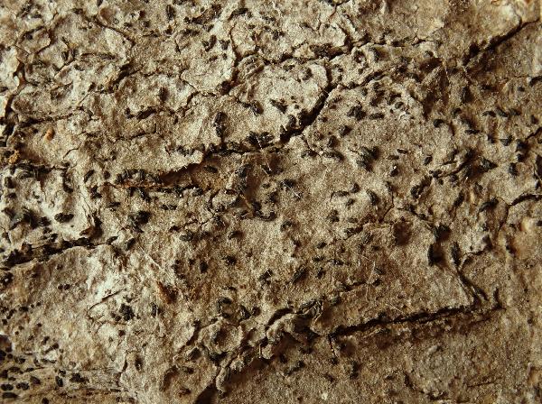
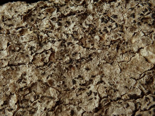
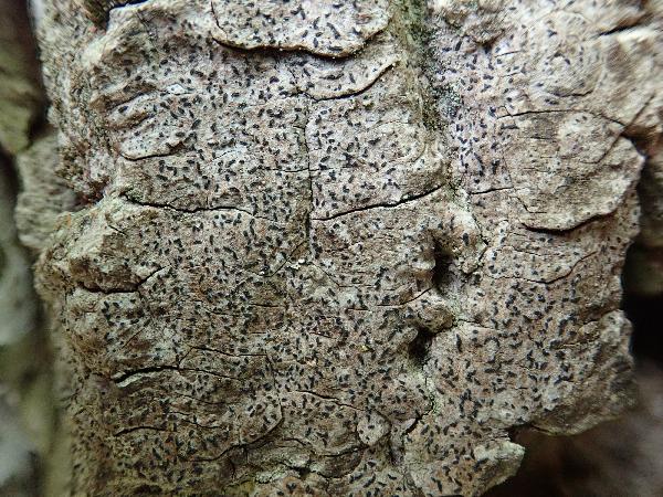
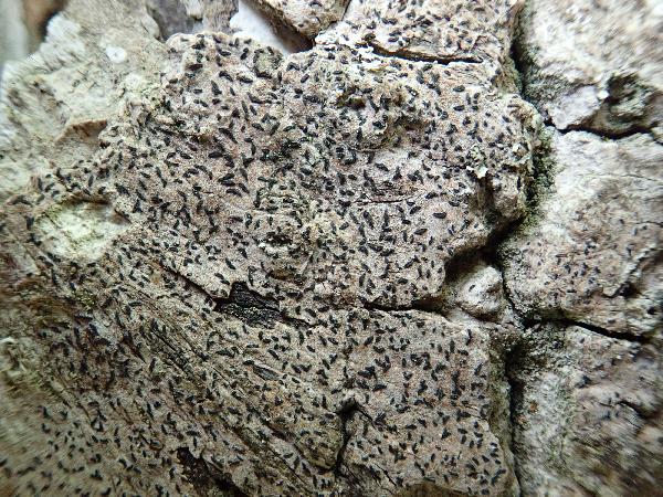
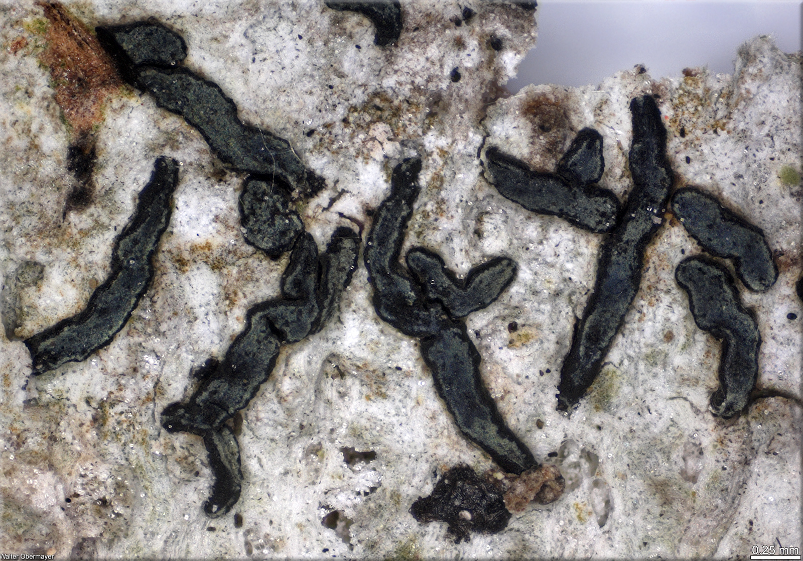
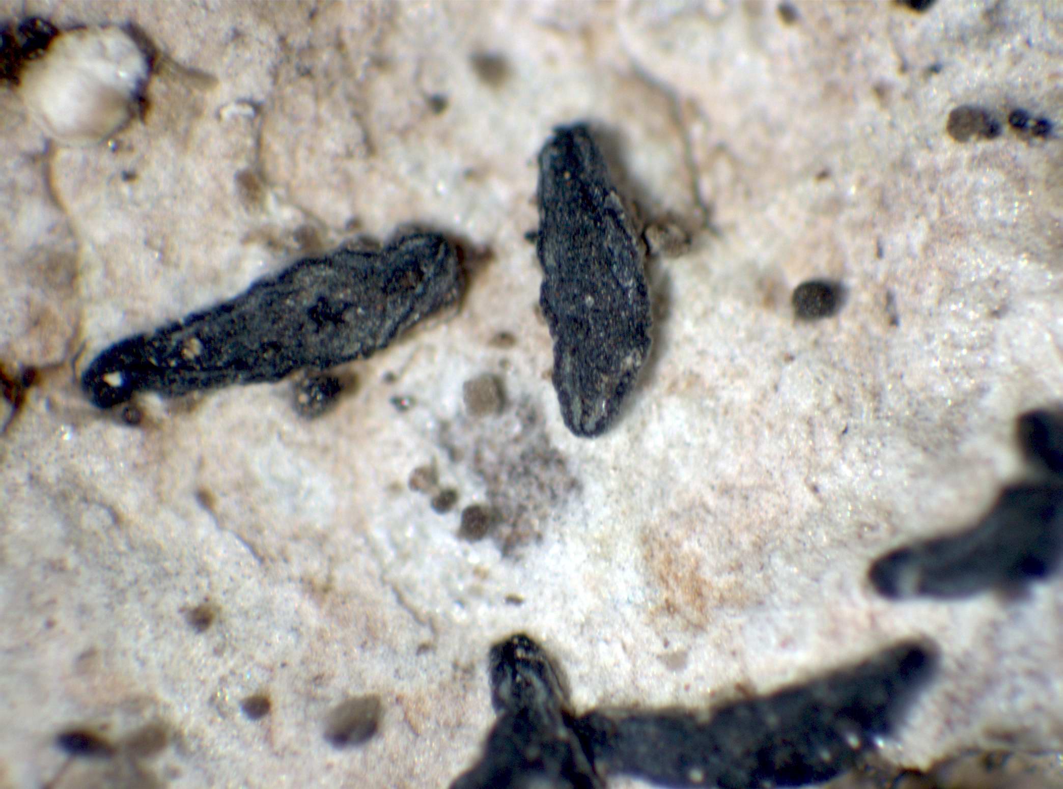
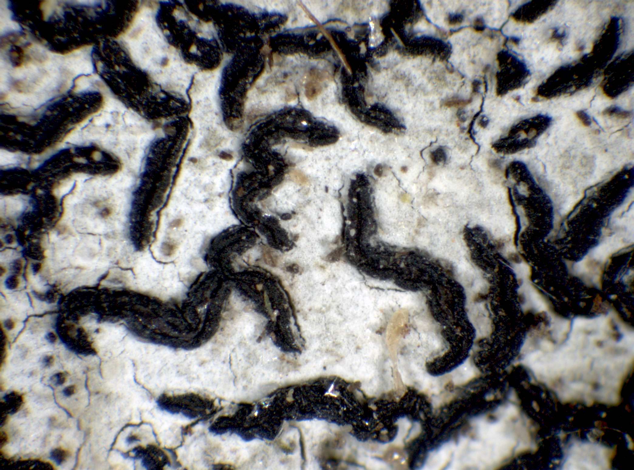
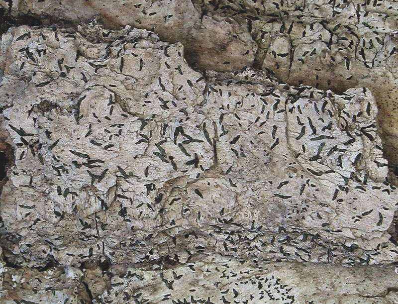
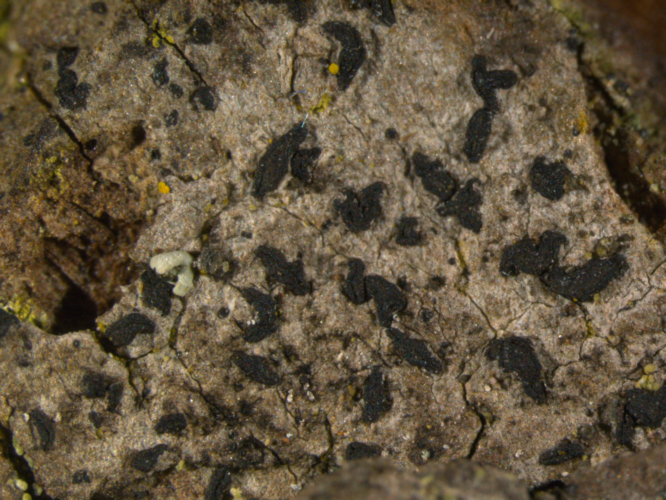
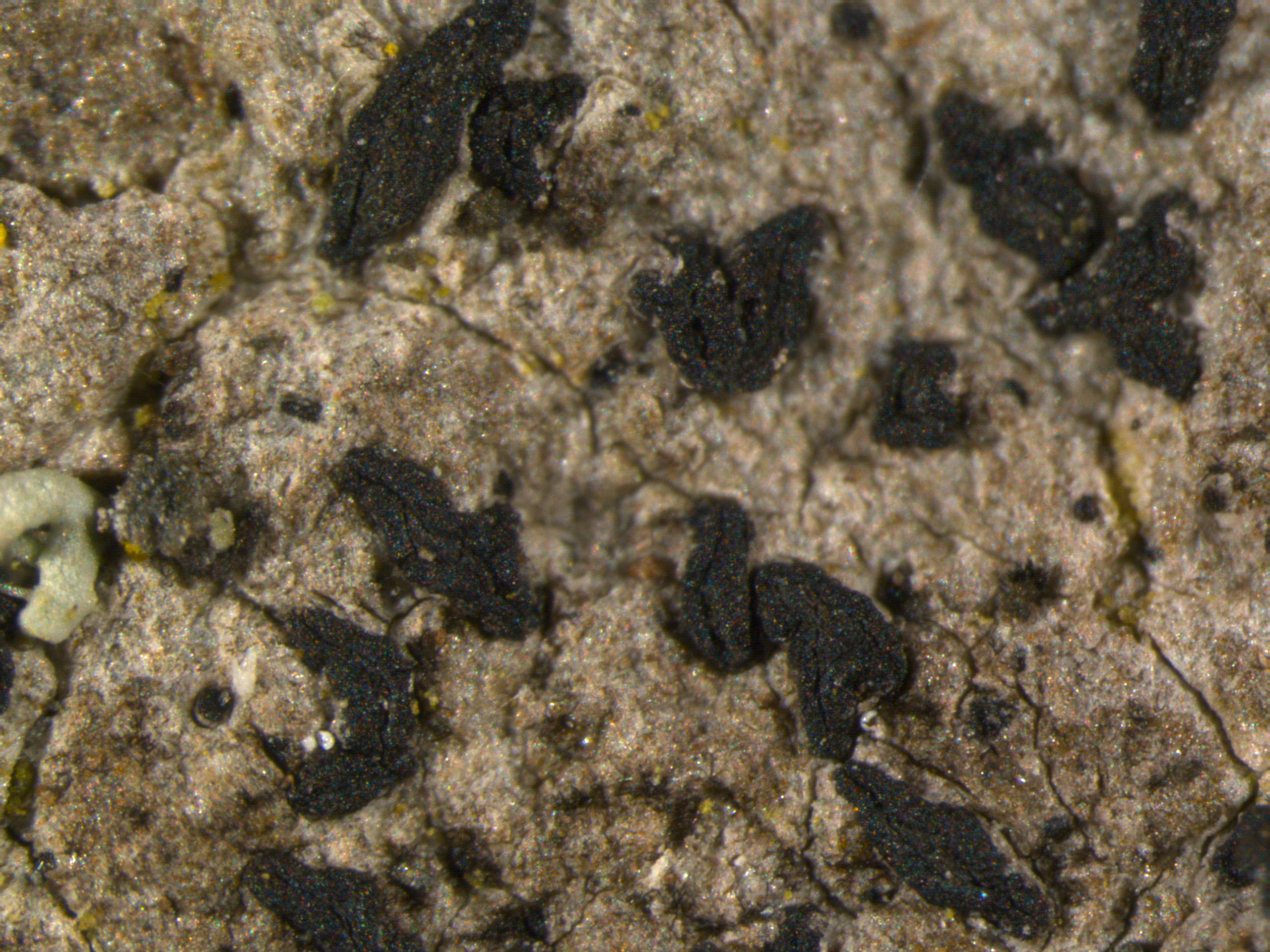
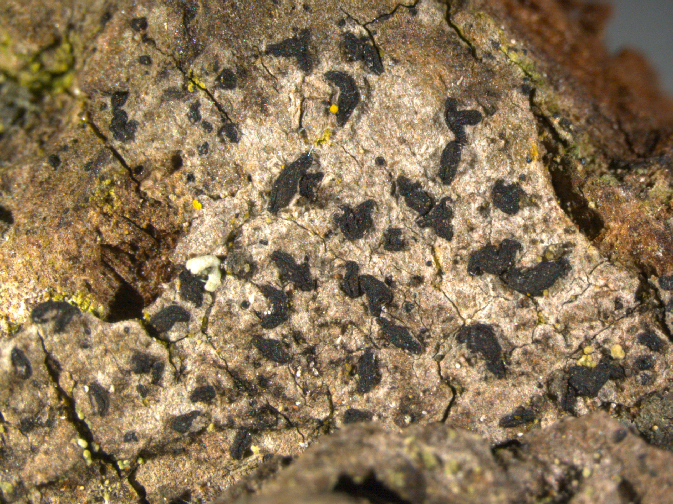
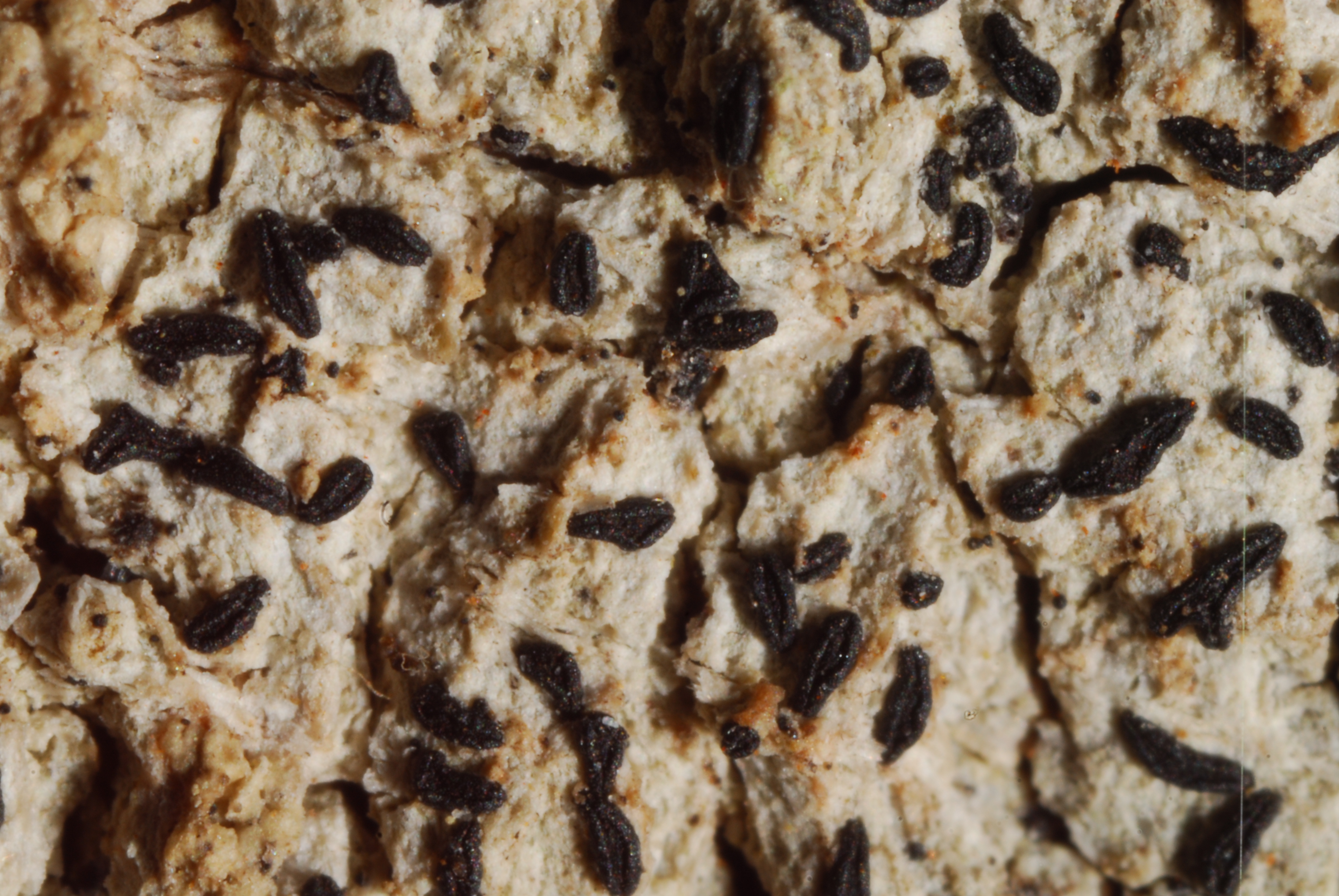
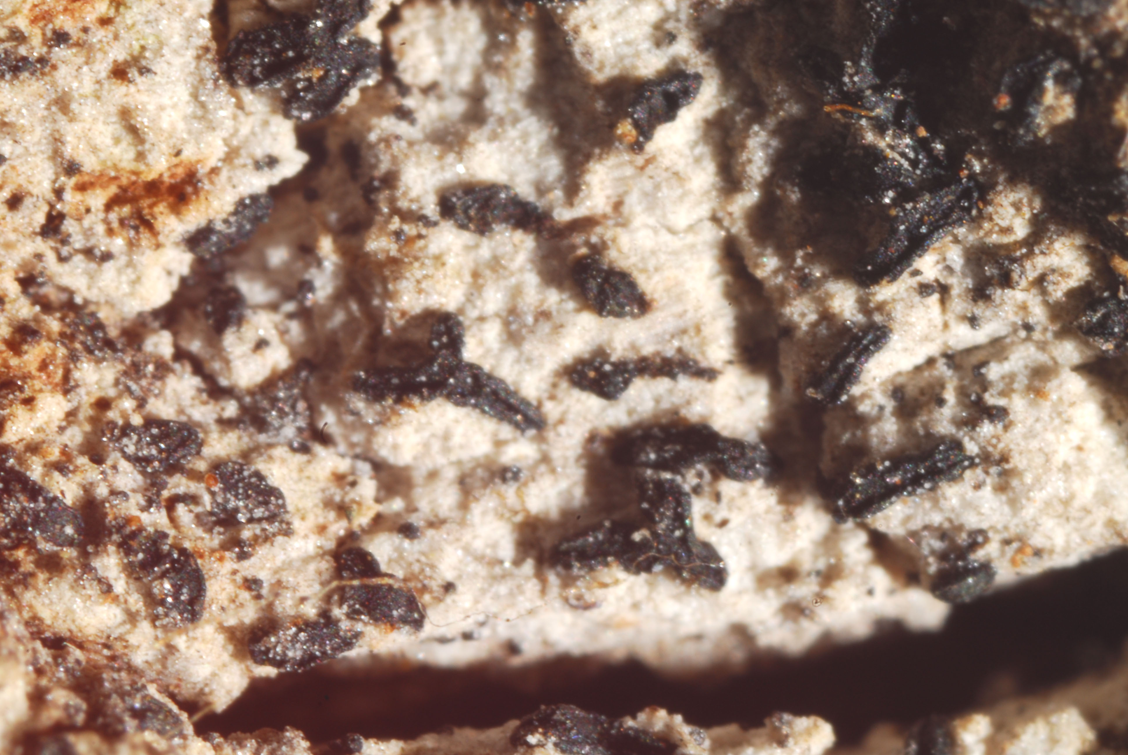
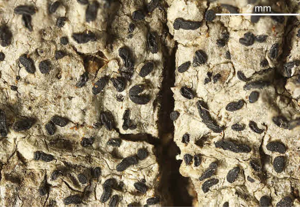
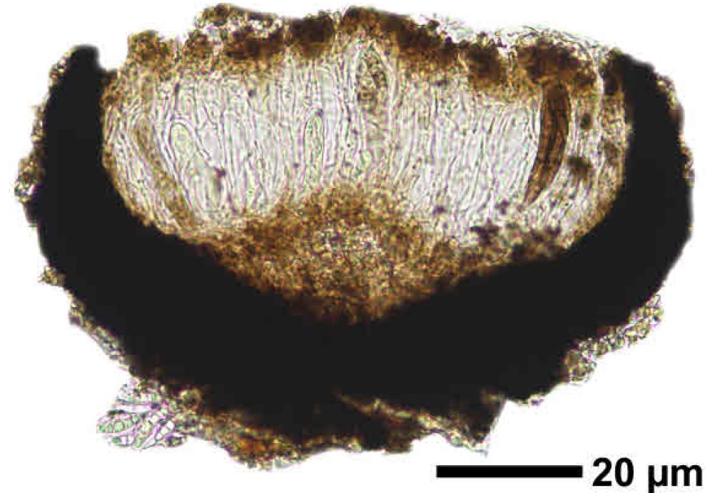
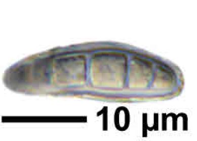
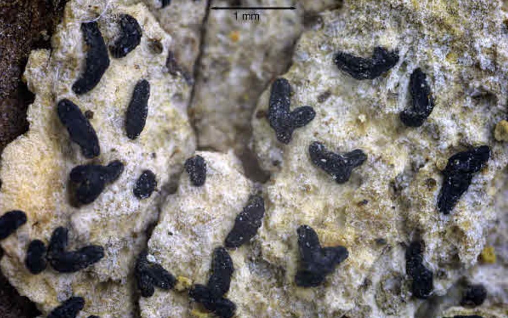
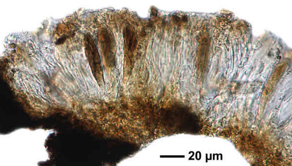
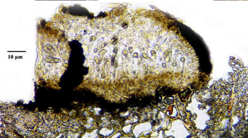
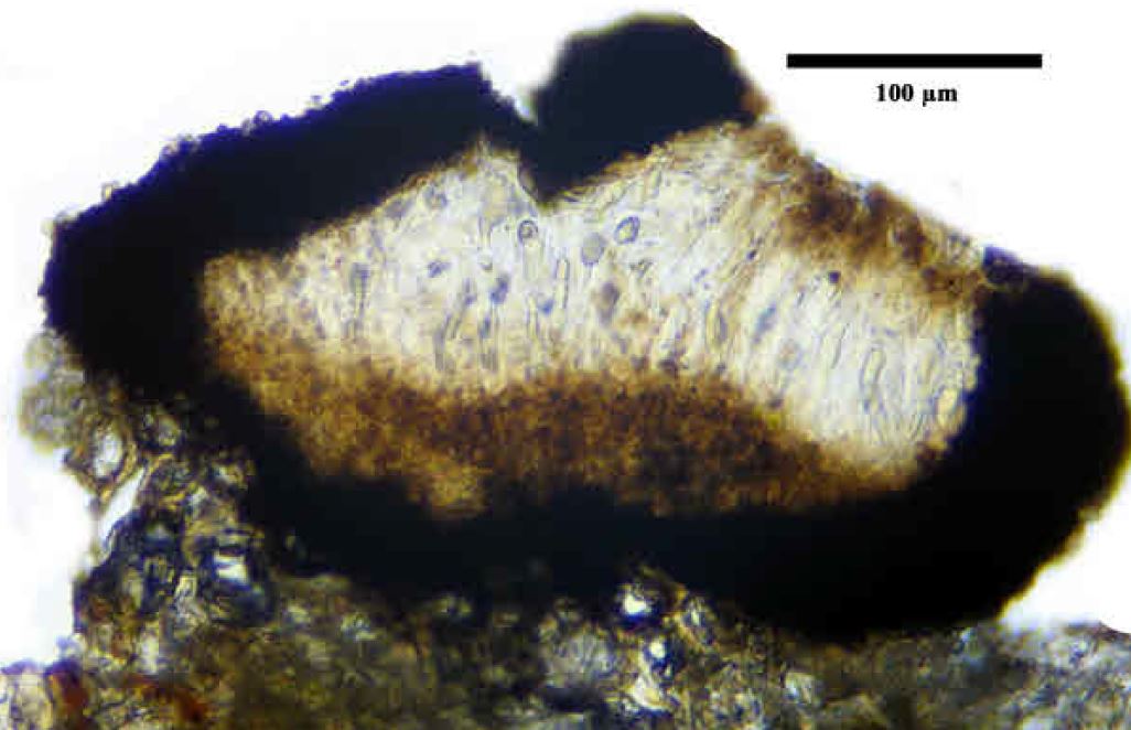
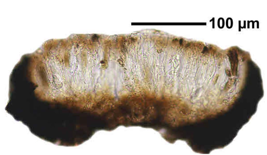
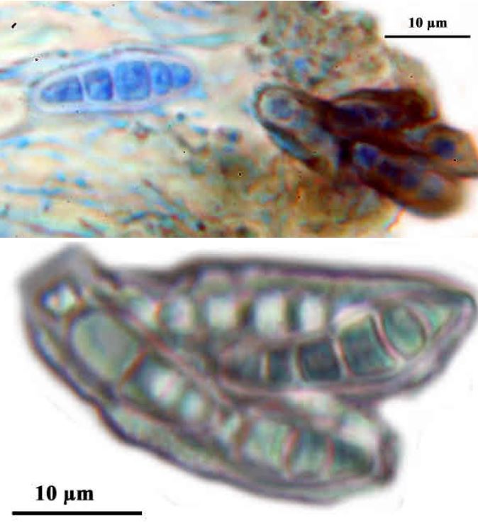
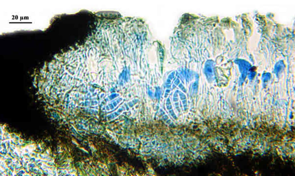
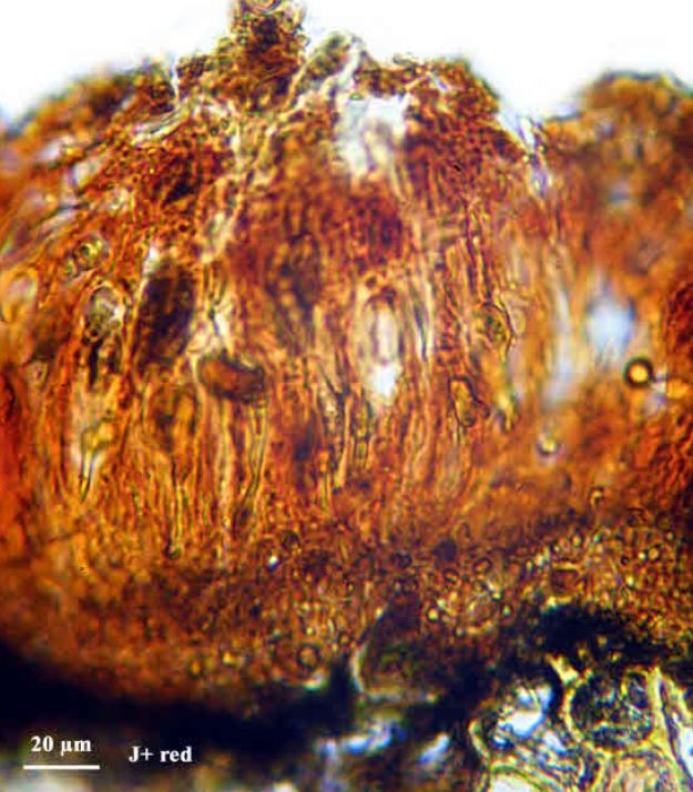
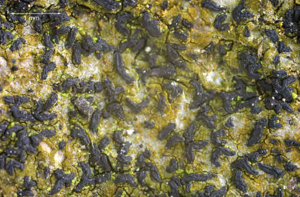
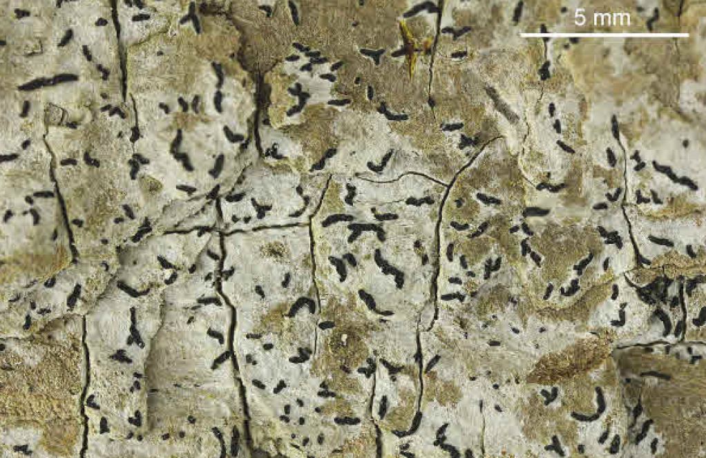
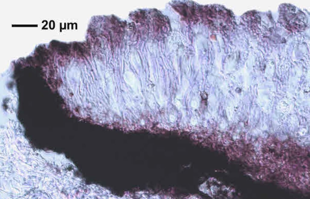
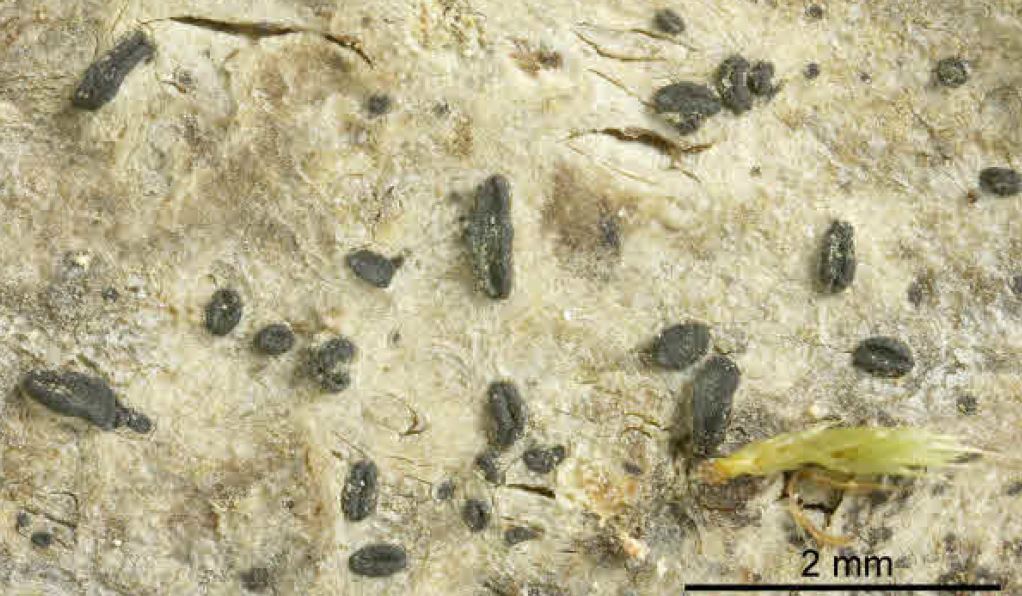
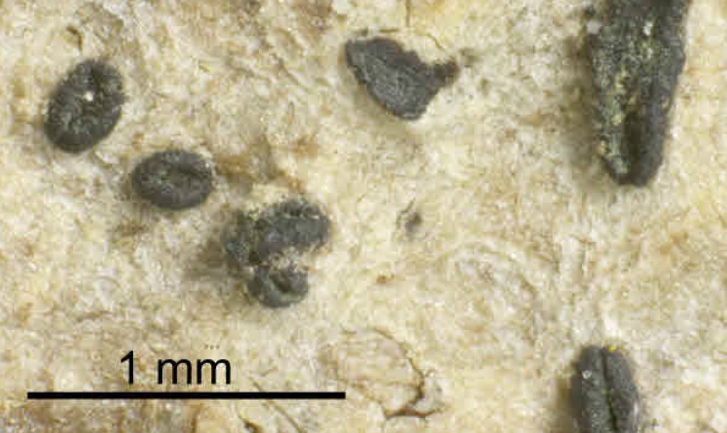
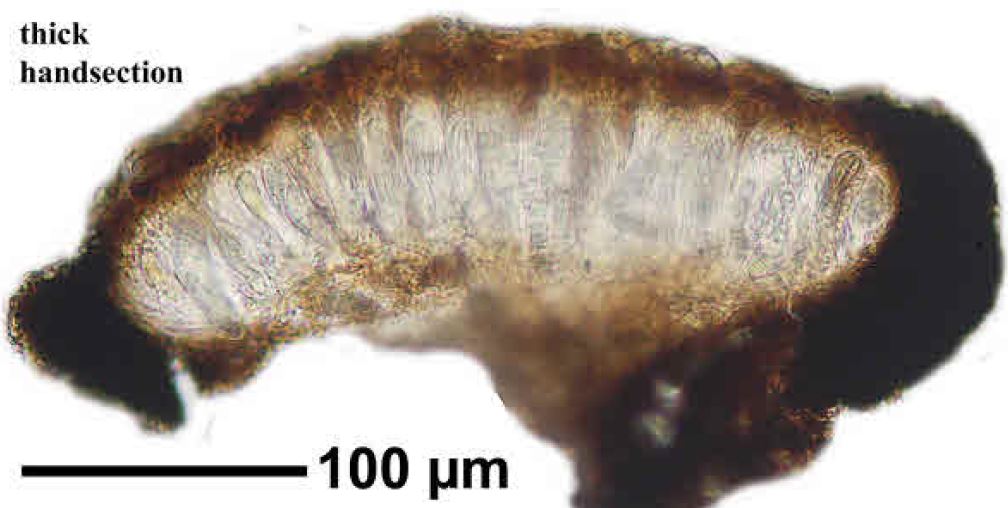
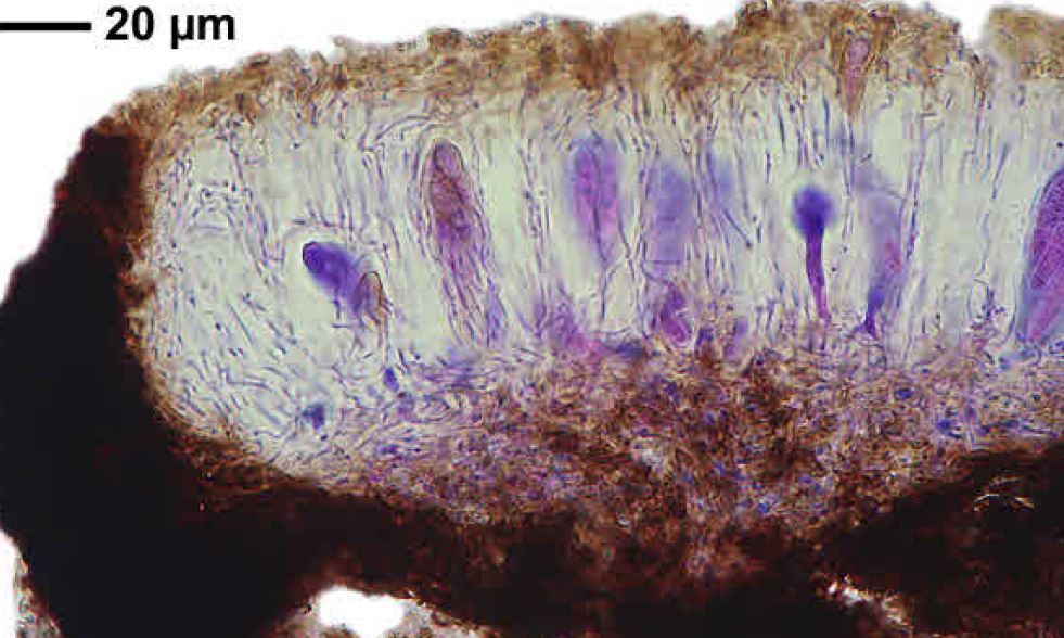
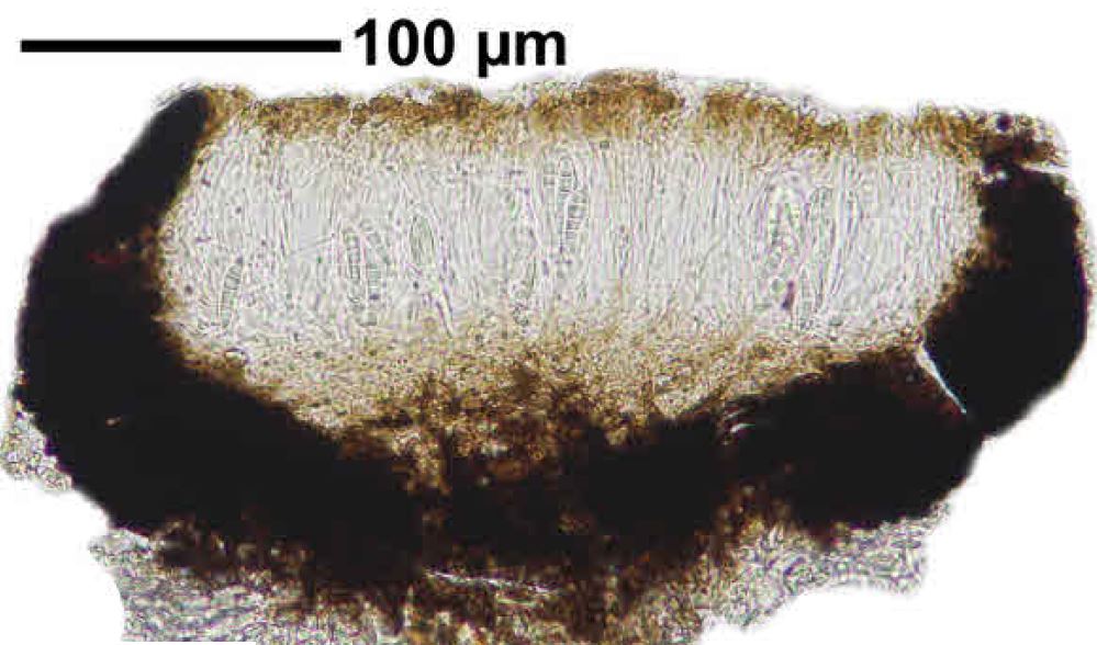
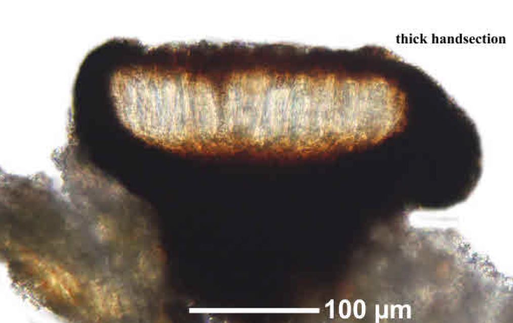
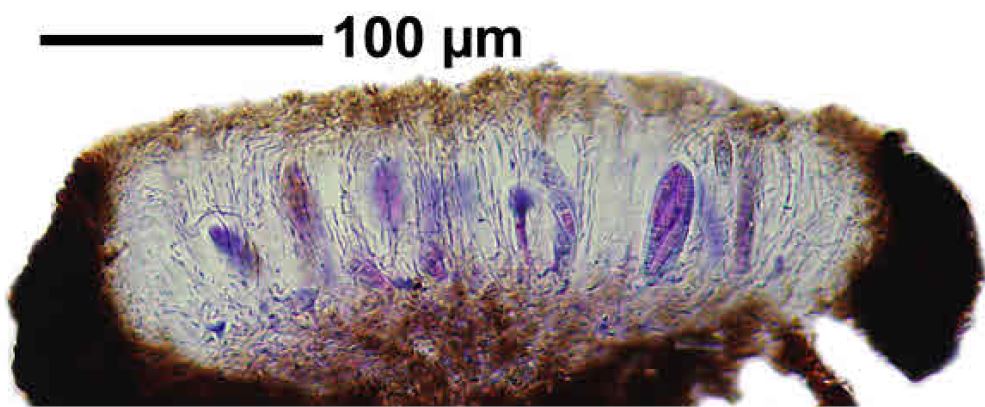
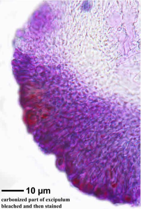
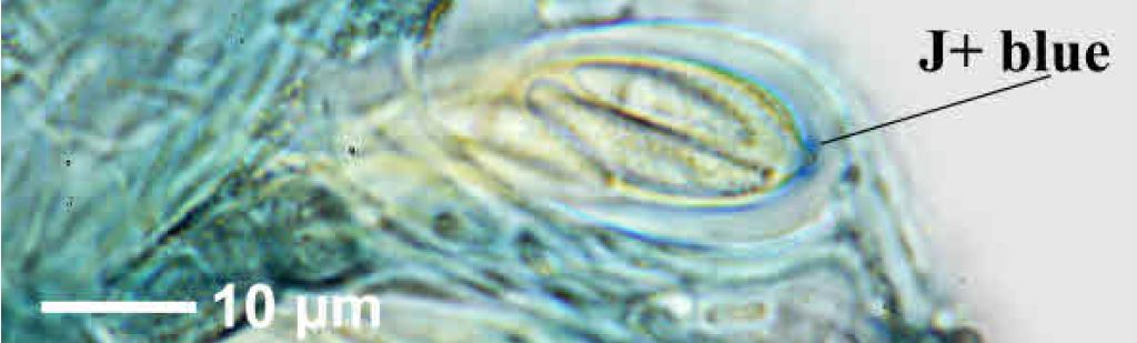
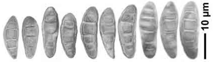
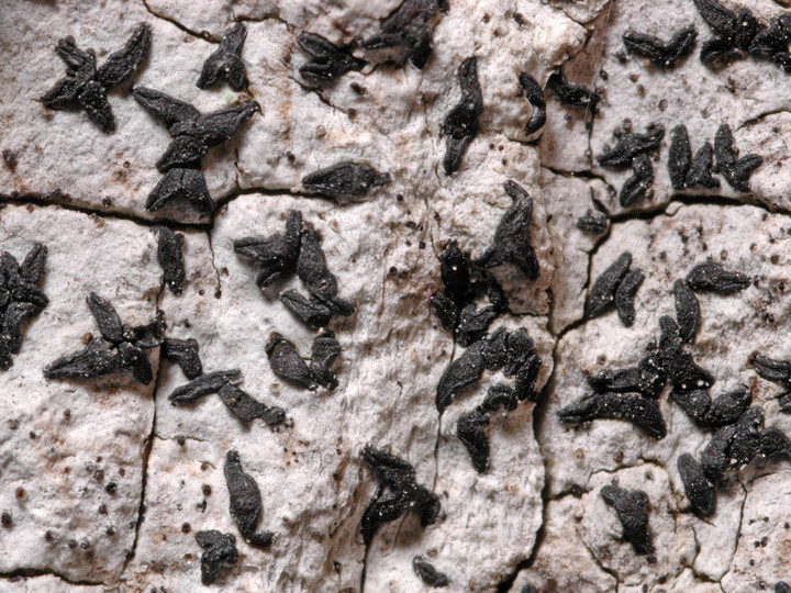
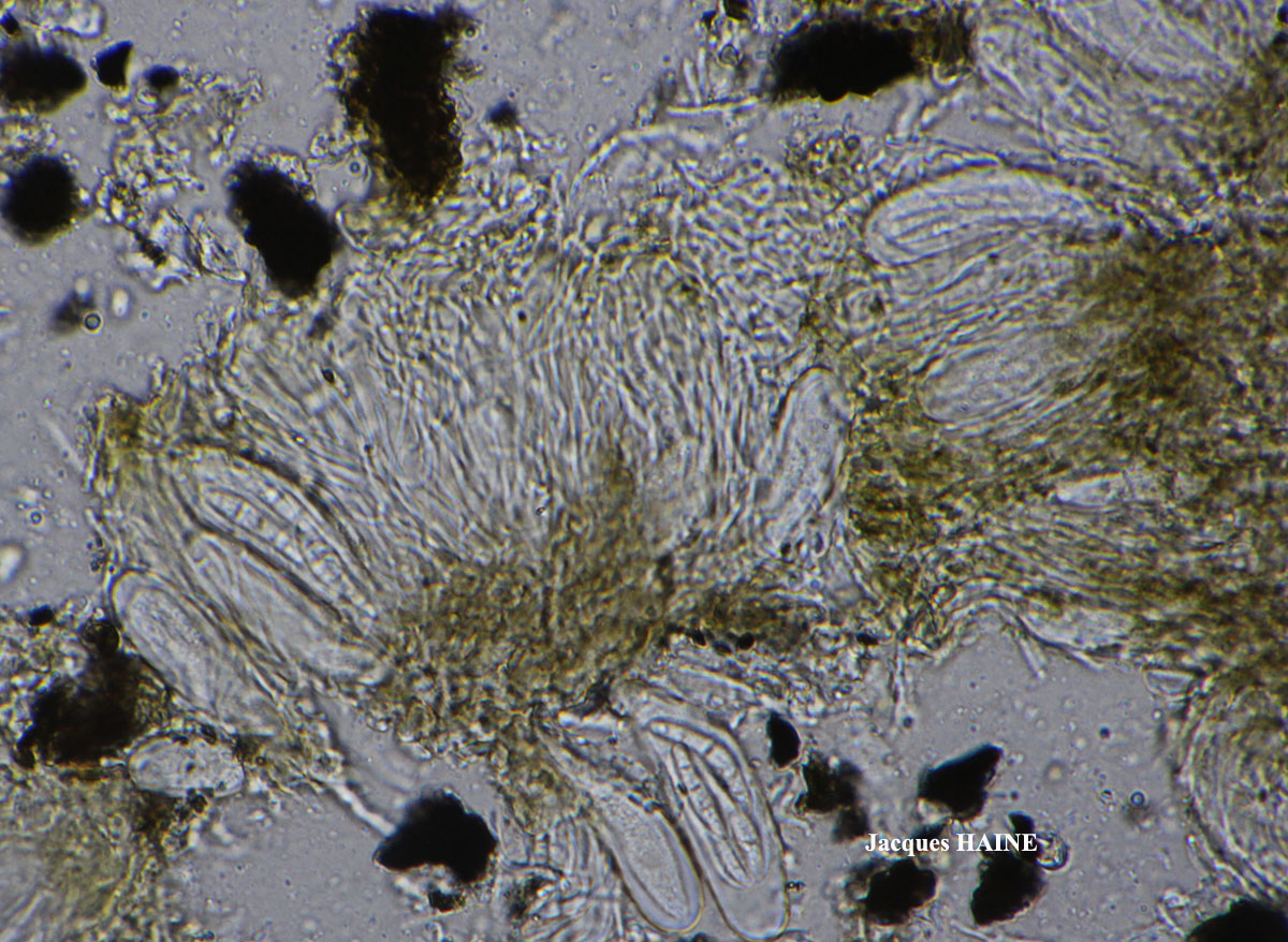
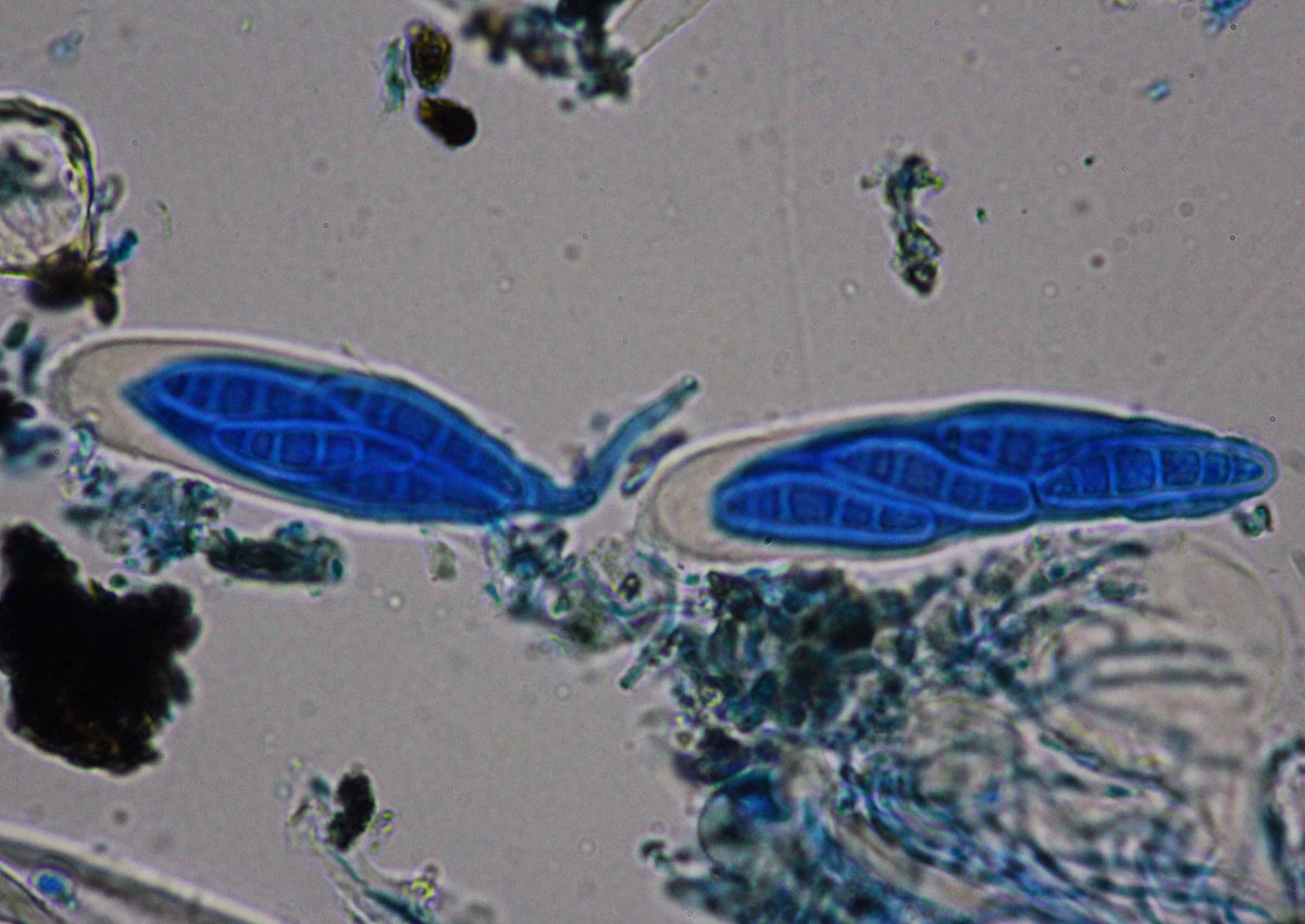
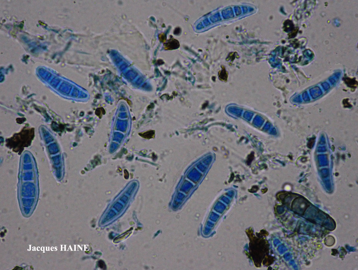
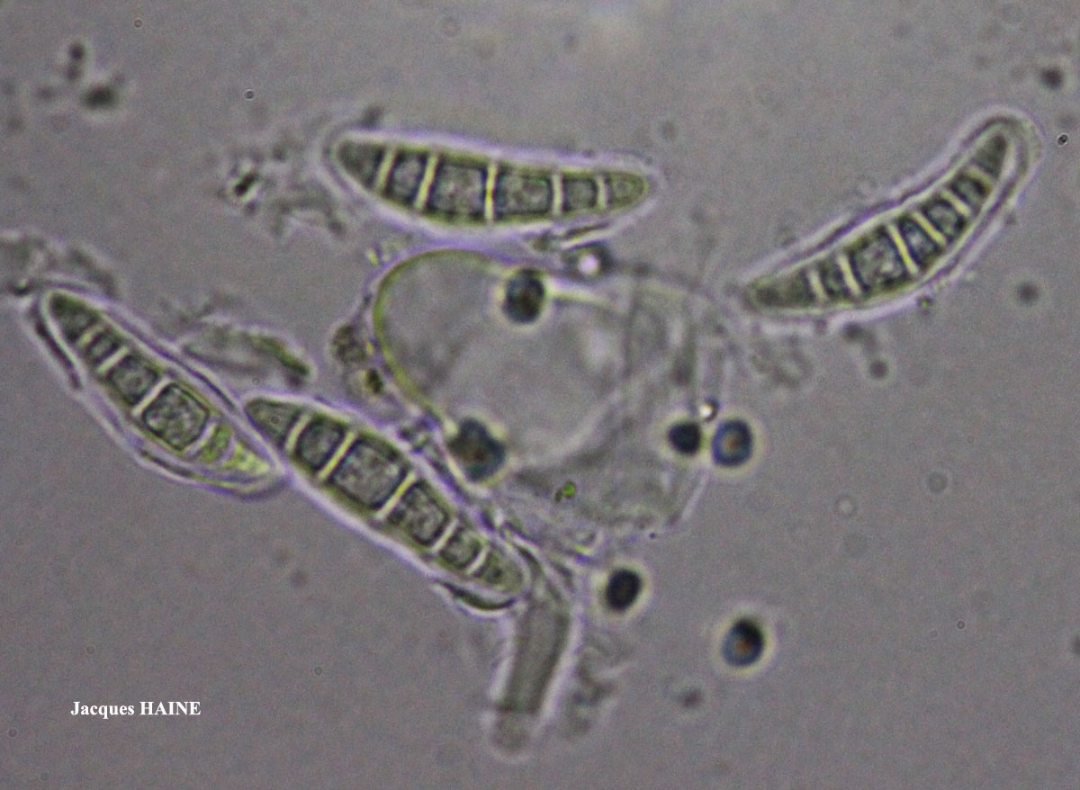
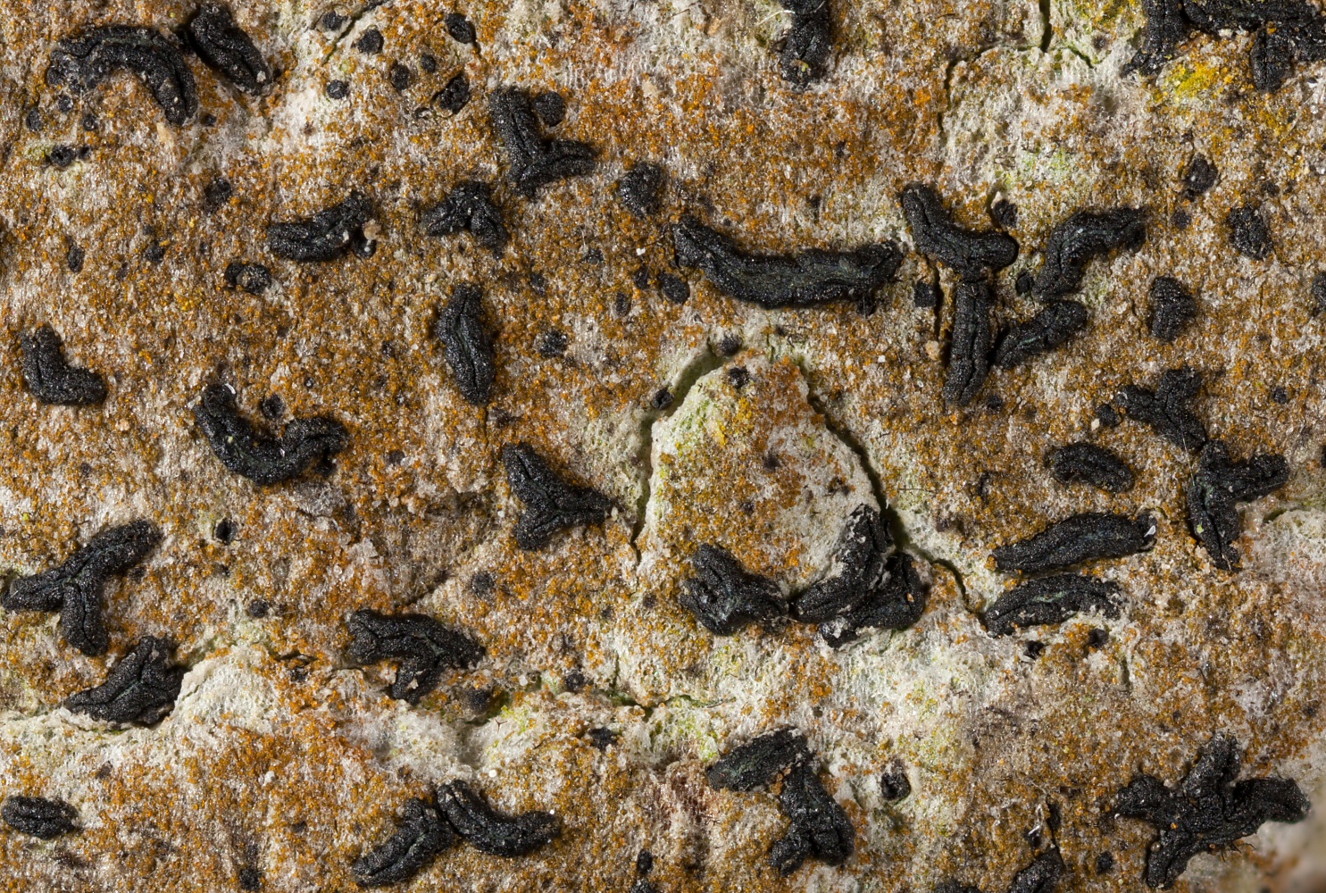
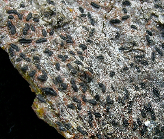
Description: Thallus crustose, thin, smooth or finely cracked, whitish to dark grey, sometimes poorly evident. Apothecia lirelliform, black, (0.3-)0.5-2.5(-4) x 0.2-0.5(-0.8) mm, mostly elongate, sometimes oblong, rarely branched, sessile, with a slit-like to slightly expanded, sometimes more or less grey- or green-pruinose disc. Proper exciple dark, carbonized, extending below the hymenium, 20-45 µm thick laterally, K-; epithecium brown, 15-25 µm high, K- (when pruinose, the pruina reacts K+ yellow); hymenium colourless, (40-)60-80(-90) µm high, hemiamyloid; paraphysoids branched and anastomosing, 1-1.5 µm thick; subhymenium dark brown; hypothecium black, carbonized. Asci 8-spored, cylindrical-clavate, the inner layer of endoascus amyloid in upper part, with a I+ blue ring visible around a small ocular chamber, Varia-type, 30-70 x 12-18(-20) µm. Ascospores 4-6-septate, somewhat clavate, the central cell distinctly enlarged, hyaline but turning brown with age, (15-)20-34(-37) x (4-)6-7(-9) µm, with a hyaline, 1-2 µm thick, gelatinous perispore. Pycnidia semi-immersed, often faintly white- or greenish-pruinose, (100-)120-200(-250) μm across. Conidia bacilliform to dumbbell-shaped, straight or slightly curved, 3-5 x 0.5-1.5(-2) µm. Photobiont trentepohlioid. Spot tests: thallus K-, KC-, C-, P-, UV-. Chemistry: without lichen substances.
Growth form: Crustose
Substrata: bark
Photobiont: Trentepohlia
Reproductive strategy: mainly sexual
Commonnes-rarity: (info)
Alpine belt: absent
Subalpine belt: extremely rare
Montane belt: very rare
Dry submediterranean belt: rare
Humid submediterranean belt: rather rare
Padanian area: extremely rare
pH of the substrata:
1 2 3 4 5

Solar irradiation:
1 2 3 4 5
Aridity:
1 2 3 4 5
Eutrophication:
1 2 3 4 5
Poleotolerance:
0 1 2 3
Altitudinal distribution:
1 2 3 4 5 6
Rarity
absent
extremely rare
very rare
rare
rather rare
rather common
common
very common
extremely common
Loading data...
Occurrence data
Predictive map

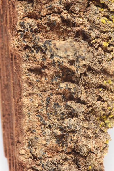
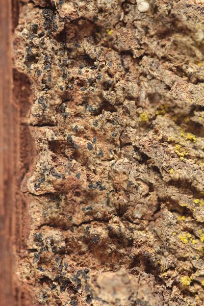
Walter Obermayer CC BY-SA 4.0 - Source: Lichens of Noricum - http://lichens-of-noricum.uni-graz.at/
P.L. Nimis; Owner: Department of Life Sciences, University of Trieste
Herbarium: TSB (7615)
2001/11/27

P.L. Nimis; Owner: Department of Life Sciences, University of Trieste
Herbarium: TSB (7615)
2001/11/27
P.L. Nimis; Owner: Department of Life Sciences, University of Trieste
Herbarium: TSB (19647)
2001/11/27
P.L. Nimis; Owner: Department of Life Sciences, University of Trieste
Herbarium: TSB (19647)
2001/11/27

Andres Saag; Owner: University of Tartu
Juri Nascimbene; Owner: Department of Life Sciences, University of Trieste
Italy, Trentino-Alto Adige, Trento, Villa Welsperg, Centro Visitatori del Parco di Paneveggio; altitude: 1030 m
03.04.2009
Juri Nascimbene; Owner: Department of Life Sciences, University of Trieste
Italy, Trentino-Alto Adige, Trento, Villa Welsperg, Centro Visitatori del Parco di Paneveggio; altitude: 1030 m
03.04.2009
Juri Nascimbene; Owner: Department of Life Sciences, University of Trieste
Italy, Trentino-Alto Adige, Trento, Villa Welsperg, Centro Visitatori del Parco di Paneveggio; altitude: 1030 m
03.04.2009
Juri Nascimbene; Owner: Department of Life Sciences, University of Trieste
Italy, Trentino-Alto Adige, Trento, Villa Welsperg, Centro Visitatori del Parco di Paneveggio; altitude: 1030 m
03.04.2009
Domenico Puntillo; Owner: Domenico Puntillo
Italy
Domenico Puntillo; Owner: Domenico Puntillo
Italy
Domenico Puntillo; Owner: Domenico Puntillo
Italy
Curtis Randall Björk, - CC BY-SA 4.0
Campus of Royal Roads University, Victoria, British Columbia, Canada Canada
2017

Felix Schumm – CC BY-SA 4.0
[1030], Gemany, Baden-Württemberg, Schwäbische Alb, Kreis Heidenheim, im Wental an Laubbäumen, ca 600 m. TK: 7226. Leg. F. Schumm 04.1967, det. F. Schumm.
Felix Schumm – CC BY-SA 4.0
[1030], Gemany, Baden-Württemberg, Schwäbische Alb, Kreis Heidenheim, im Wental an Laubbäumen, ca 600 m. TK: 7226. Leg. F. Schumm 04.1967, det. F. Schumm.
Felix Schumm – CC BY-SA 4.0
[1030], Gemany, Baden-Württemberg, Schwäbische Alb, Kreis Heidenheim, im Wental an Laubbäumen, ca 600 m. TK: 7226. Leg. F. Schumm 04.1967, det. F. Schumm.
Felix Schumm – CC BY-SA 4.0
[1030], Gemany, Baden-Württemberg, Schwäbische Alb, Kreis Heidenheim, im Wental an Laubbäumen, ca 600 m. TK: 7226. Leg. F. Schumm 04.1967, det. F. Schumm.
Felix Schumm – CC BY-SA 4.0
[1030], Gemany, Baden-Württemberg, Schwäbische Alb, Kreis Heidenheim, im Wental an Laubbäumen, ca 600 m. TK: 7226. Leg. F. Schumm 04.1967, det. F. Schumm.

Felix Schumm – CC BY-SA 4.0
[1030], Gemany, Baden-Württemberg, Schwäbische Alb, Kreis Heidenheim, im Wental an Laubbäumen, ca 600 m. TK: 7226. Leg. F. Schumm 04.1967, det. F. Schumm.
Felix Schumm – CC BY-SA 4.0
[6967], Germany, Baden-Württemberg, Rems-Murr-Kreis, 5 km westlich von Welzheim im Rotal, Stubensandsteingebiet, an Eiche, luftfeucht; 440 m, TK: 7124/NW. Leg. Schumm & Schwarz 23.04.2000, det. F. Schumm 2007

Felix Schumm – CC BY-SA 4.0
[6967], Germany, Baden-Württemberg, Rems-Murr-Kreis, 5 km westlich von Welzheim im Rotal, Stubensandsteingebiet, an Eiche, luftfeucht; 440 m, TK: 7124/NW. Leg. Schumm & Schwarz 23.04.2000, det. F. Schumm 2007
Felix Schumm – CC BY-SA 4.0
[6967], Germany, Baden-Württemberg, Rems-Murr-Kreis, 5 km westlich von Welzheim im Rotal, Stubensandsteingebiet, an Eiche, luftfeucht; 440 m, TK: 7124/NW. Leg. Schumm & Schwarz 23.04.2000, det. F. Schumm 2007

Felix Schumm – CC BY-SA 4.0
[6967], Germany, Baden-Württemberg, Rems-Murr-Kreis, 5 km westlich von Welzheim im Rotal, Stubensandsteingebiet, an Eiche, luftfeucht; 440 m, TK: 7124/NW. Leg. Schumm & Schwarz 23.04.2000, det. F. Schumm 2007
Felix Schumm – CC BY-SA 4.0
[6967], Germany, Baden-Württemberg, Rems-Murr-Kreis, 5 km westlich von Welzheim im Rotal, Stubensandsteingebiet, an Eiche, luftfeucht; 440 m, TK: 7124/NW. Leg. Schumm & Schwarz 23.04.2000, det. F. Schumm 2007
Felix Schumm – CC BY-SA 4.0
[6967], Germany, Baden-Württemberg, Rems-Murr-Kreis, 5 km westlich von Welzheim im Rotal, Stubensandsteingebiet, an Eiche, luftfeucht; 440 m, TK: 7124/NW. Leg. Schumm & Schwarz 23.04.2000, det. F. Schumm 2007

Felix Schumm – CC BY-SA 4.0
[6967], Germany, Baden-Württemberg, Rems-Murr-Kreis, 5 km westlich von Welzheim im Rotal, Stubensandsteingebiet, an Eiche, luftfeucht; 440 m, TK: 7124/NW. Leg. Schumm & Schwarz 23.04.2000, det. F. Schumm 2007
Felix Schumm – CC BY-SA 4.0
[6967], Germany, Baden-Württemberg, Rems-Murr-Kreis, 5 km westlich von Welzheim im Rotal, Stubensandsteingebiet, an Eiche, luftfeucht; 440 m, TK: 7124/NW. Leg. Schumm & Schwarz 23.04.2000, det. F. Schumm 2007

Felix Schumm – CC BY-SA 4.0
[6967], Germany, Baden-Württemberg, Rems-Murr-Kreis, 5 km westlich von Welzheim im Rotal, Stubensandsteingebiet, an Eiche, luftfeucht; 440 m, TK: 7124/NW. Leg. Schumm & Schwarz 23.04.2000, det. F. Schumm 2007
Felix Schumm – CC BY-SA 4.0
[6967], Germany, Baden-Württemberg, Rems-Murr-Kreis, 5 km westlich von Welzheim im Rotal, Stubensandsteingebiet, an Eiche, luftfeucht; 440 m, TK: 7124/NW. Leg. Schumm & Schwarz 23.04.2000, det. F. Schumm 2007
Felix Schumm – CC BY-SA 4.0
[6967], Germany, Baden-Württemberg, Rems-Murr-Kreis, 5 km westlich von Welzheim im Rotal, Stubensandsteingebiet, an Eiche, luftfeucht; 440 m, TK: 7124/NW. Leg. Schumm & Schwarz 23.04.2000, det. F. Schumm 2007
Felix Schumm – CC BY-SA 4.0
[6967], Germany, Baden-Württemberg, Rems-Murr-Kreis, 5 km westlich von Welzheim im Rotal, Stubensandsteingebiet, an Eiche, luftfeucht; 440 m, TK: 7124/NW. Leg. Schumm & Schwarz 23.04.2000, det. F. Schumm 2007
Felix Schumm – CC BY-SA 4.0
[13631], Germany, Baden-Württemberg, Kreis Göppingen, südwestlich von Adelberg nahe dem Herrenbachstausee, Buhwiesenweg, corticol im Mischwald, ca. 48°44'N, 9°33'E, 412 m. Leg. Schumm 08.02.2008

Felix Schumm – CC BY-SA 4.0
[13631], Germany, Baden-Württemberg, Kreis Göppingen, südwestlich von Adelberg nahe dem Herrenbachstausee, Buhwiesenweg, corticol im Mischwald, ca. 48°44'N, 9°33'E, 412 m. Leg. Schumm 08.02.2008
Felix Schumm – CC BY-SA 4.0
[13631], Germany, Baden-Württemberg, Kreis Göppingen, südwestlich von Adelberg nahe dem Herrenbachstausee, Buhwiesenweg, corticol im Mischwald, ca. 48°44'N, 9°33'E, 412 m. Leg. Schumm 08.02.2008
Felix Schumm – CC BY-SA 4.0
[13631], Germany, Baden-Württemberg, Kreis Göppingen, südwestlich von Adelberg nahe dem Herrenbachstausee, Buhwiesenweg, corticol im Mischwald, ca. 48°44'N, 9°33'E, 412 m. Leg. Schumm 08.02.2008
Felix Schumm – CC BY-SA 4.0
[13631], Germany, Baden-Württemberg, Kreis Göppingen, südwestlich von Adelberg nahe dem Herrenbachstausee, Buhwiesenweg, corticol im Mischwald, ca. 48°44'N, 9°33'E, 412 m. Leg. Schumm 08.02.2008
Felix Schumm – CC BY-SA 4.0
[16464], GERMANY, Baden-Württemberg, Kreis Göppingen, im Herrenbachtal zwischen Rechberghausen und der Zachersmühle, 48.74100°N, 9.62803° E, 330 m. Leg. Schumm 11.04.2010.
Felix Schumm – CC BY-SA 4.0
[16464], GERMANY, Baden-Württemberg, Kreis Göppingen, im Herrenbachtal zwischen Rechberghausen und der Zachersmühle, 48.74100°N, 9.62803° E, 330 m. Leg. Schumm 11.04.2010.
Felix Schumm – CC BY-SA 4.0
[16464], GERMANY, Baden-Württemberg, Kreis Göppingen, im Herrenbachtal zwischen Rechberghausen und der Zachersmühle, 48.74100°N, 9.62803° E, 330 m. Leg. Schumm 11.04.2010.
Felix Schumm – CC BY-SA 4.0
[16464], GERMANY, Baden-Württemberg, Kreis Göppingen, im Herrenbachtal zwischen Rechberghausen und der Zachersmühle, 48.74100°N, 9.62803° E, 330 m. Leg. Schumm 11.04.2010.
Felix Schumm – CC BY-SA 4.0
[18569], Germany, Rheinland-Pfalz, Kreis Kaiserslautern, Pfälzer Wald, Karlstal südwestlich von Trippstadt, 300-350 m, Buntsandsteingebiet, Schluchtwald (Luzulo-Fagetum), an Fagus sylvatica. Leg. Schumm & Lauer 10.06.1978, det. Schumm.

Felix Schumm – CC BY-SA 4.0
[18569], Germany, Rheinland-Pfalz, Kreis Kaiserslautern, Pfälzer Wald, Karlstal südwestlich von Trippstadt, 300-350 m, Buntsandsteingebiet, Schluchtwald (Luzulo-Fagetum), an Fagus sylvatica. Leg. Schumm & Lauer 10.06.1978, det. Schumm.

Felix Schumm – CC BY-SA 4.0
[18569], Germany, Rheinland-Pfalz, Kreis Kaiserslautern, Pfälzer Wald, Karlstal südwestlich von Trippstadt, 300-350 m, Buntsandsteingebiet, Schluchtwald (Luzulo-Fagetum), an Fagus sylvatica. Leg. Schumm & Lauer 10.06.1978, det. Schumm.
Felix Schumm – CC BY-SA 4.0
[18569], Germany, Rheinland-Pfalz, Kreis Kaiserslautern, Pfälzer Wald, Karlstal südwestlich von Trippstadt, 300-350 m, Buntsandsteingebiet, Schluchtwald (Luzulo-Fagetum), an Fagus sylvatica. Leg. Schumm & Lauer 10.06.1978, det. Schumm.

Felix Schumm – CC BY-SA 4.0
[18569], Germany, Rheinland-Pfalz, Kreis Kaiserslautern, Pfälzer Wald, Karlstal südwestlich von Trippstadt, 300-350 m, Buntsandsteingebiet, Schluchtwald (Luzulo-Fagetum), an Fagus sylvatica. Leg. Schumm & Lauer 10.06.1978, det. Schumm.
Felix Schumm – CC BY-SA 4.0
[18569], Germany, Rheinland-Pfalz, Kreis Kaiserslautern, Pfälzer Wald, Karlstal südwestlich von Trippstadt, 300-350 m, Buntsandsteingebiet, Schluchtwald (Luzulo-Fagetum), an Fagus sylvatica. Leg. Schumm & Lauer 10.06.1978, det. Schumm.

Felix Schumm – CC BY-SA 4.0
[18569], Germany, Rheinland-Pfalz, Kreis Kaiserslautern, Pfälzer Wald, Karlstal südwestlich von Trippstadt, 300-350 m, Buntsandsteingebiet, Schluchtwald (Luzulo-Fagetum), an Fagus sylvatica. Leg. Schumm & Lauer 10.06.1978, det. Schumm.

Felix Schumm – CC BY-SA 4.0
[18569], Germany, Rheinland-Pfalz, Kreis Kaiserslautern, Pfälzer Wald, Karlstal südwestlich von Trippstadt, 300-350 m, Buntsandsteingebiet, Schluchtwald (Luzulo-Fagetum), an Fagus sylvatica. Leg. Schumm & Lauer 10.06.1978, det. Schumm.
Felix Schumm – CC BY-SA 4.0
[18569], Germany, Rheinland-Pfalz, Kreis Kaiserslautern, Pfälzer Wald, Karlstal südwestlich von Trippstadt, 300-350 m, Buntsandsteingebiet, Schluchtwald (Luzulo-Fagetum), an Fagus sylvatica. Leg. Schumm & Lauer 10.06.1978, det. Schumm.
Felix Schumm – CC BY-SA 4.0
[18569], Germany, Rheinland-Pfalz, Kreis Kaiserslautern, Pfälzer Wald, Karlstal südwestlich von Trippstadt, 300-350 m, Buntsandsteingebiet, Schluchtwald (Luzulo-Fagetum), an Fagus sylvatica. Leg. Schumm & Lauer 10.06.1978, det. Schumm.
Felix Schumm – CC BY-SA 4.0
[18569], Germany, Rheinland-Pfalz, Kreis Kaiserslautern, Pfälzer Wald, Karlstal südwestlich von Trippstadt, 300-350 m, Buntsandsteingebiet, Schluchtwald (Luzulo-Fagetum), an Fagus sylvatica. Leg. Schumm & Lauer 10.06.1978, det. Schumm.
Felix Schumm – CC BY-SA 4.0
[18569], Germany, Rheinland-Pfalz, Kreis Kaiserslautern, Pfälzer Wald, Karlstal südwestlich von Trippstadt, 300-350 m, Buntsandsteingebiet, Schluchtwald (Luzulo-Fagetum), an Fagus sylvatica. Leg. Schumm & Lauer 10.06.1978, det. Schumm.
Felix Schumm – CC BY-SA 4.0
[18569], Germany, Rheinland-Pfalz, Kreis Kaiserslautern, Pfälzer Wald, Karlstal südwestlich von Trippstadt, 300-350 m, Buntsandsteingebiet, Schluchtwald (Luzulo-Fagetum), an Fagus sylvatica. Leg. Schumm & Lauer 10.06.1978, det. Schumm.
Felix Schumm – CC BY-SA 4.0
[18569], Germany, Rheinland-Pfalz, Kreis Kaiserslautern, Pfälzer Wald, Karlstal südwestlich von Trippstadt, 300-350 m, Buntsandsteingebiet, Schluchtwald (Luzulo-Fagetum), an Fagus sylvatica. Leg. Schumm & Lauer 10.06.1978, det. Schumm.
Felix Schumm – CC BY-SA 4.0
[18569], Germany, Rheinland-Pfalz, Kreis Kaiserslautern, Pfälzer Wald, Karlstal südwestlich von Trippstadt, 300-350 m, Buntsandsteingebiet, Schluchtwald (Luzulo-Fagetum), an Fagus sylvatica. Leg. Schumm & Lauer 10.06.1978, det. Schumm.

Felix Schumm – CC BY-SA 4.0
[18569], Germany, Rheinland-Pfalz, Kreis Kaiserslautern, Pfälzer Wald, Karlstal südwestlich von Trippstadt, 300-350 m, Buntsandsteingebiet, Schluchtwald (Luzulo-Fagetum), an Fagus sylvatica. Leg. Schumm & Lauer 10.06.1978, det. Schumm.
Pier Luigi Nimis - CC BY-SA 4.0
TSB 42159
Pier Luigi Nimis - CC BY-SA 4.0
TSB 42159
Pier Luigi Nimis - CC BY-SA 4.0
TSB 42159
Pier Luigi Nimis - CC BY-SA 4.0
TSB 38779

Leif Stridvall - Source: http://www.stridvall.se/la/galleries.php

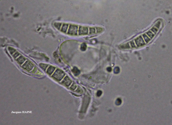
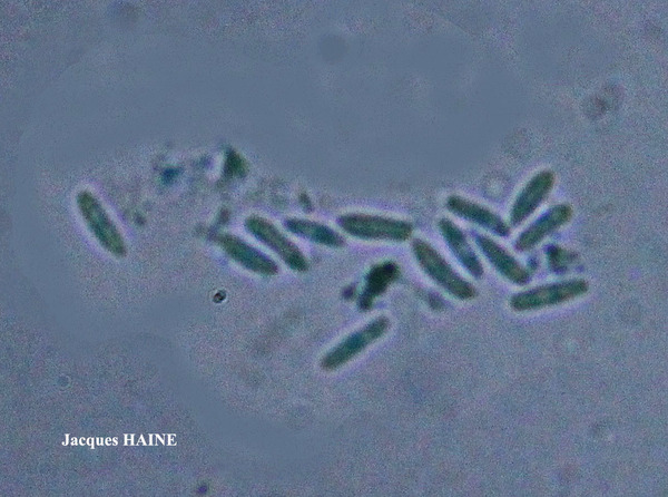
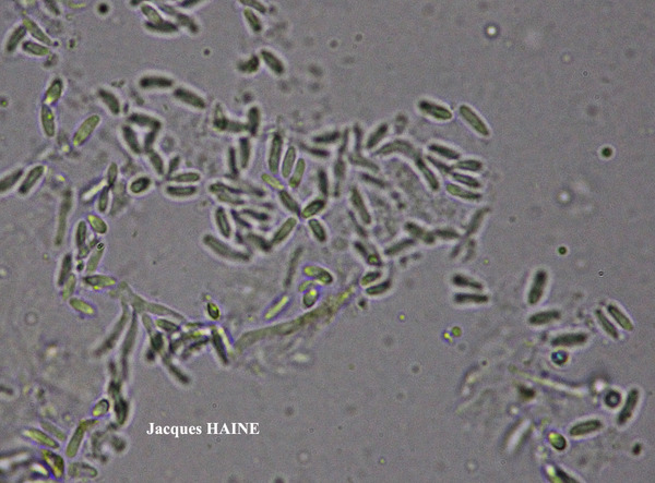
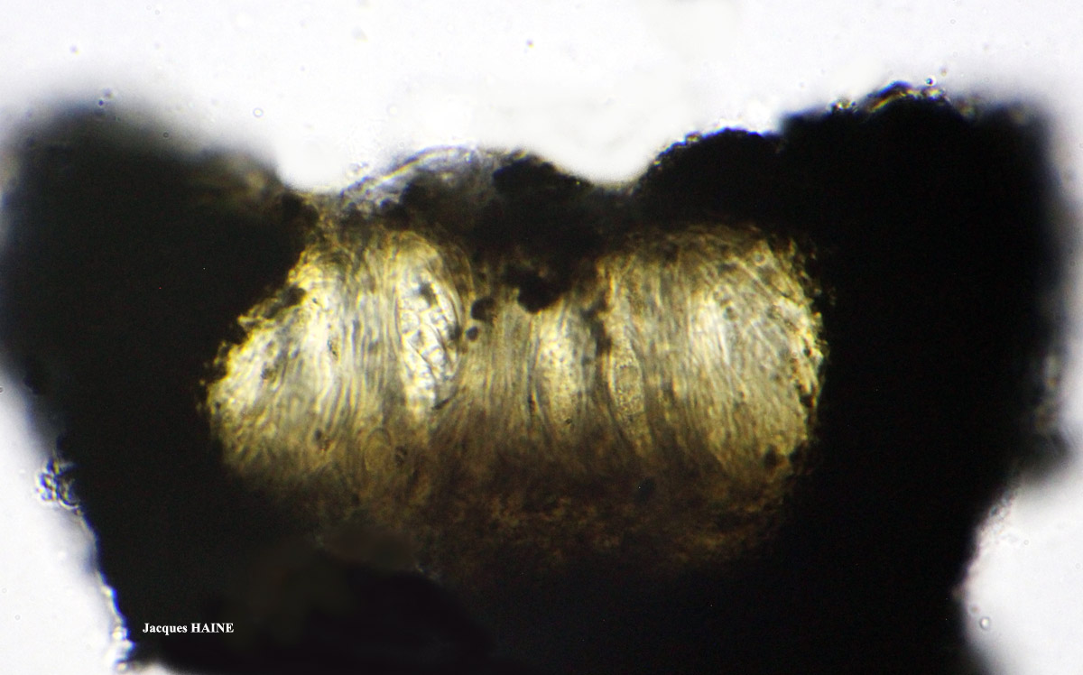
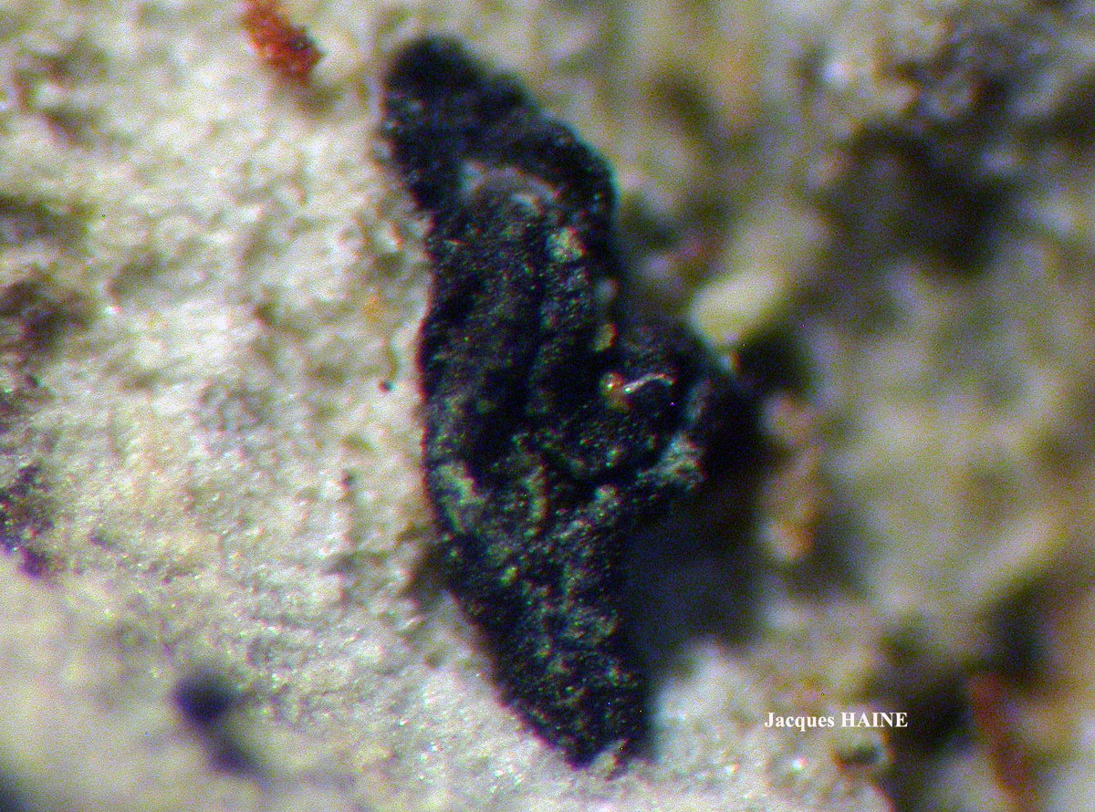
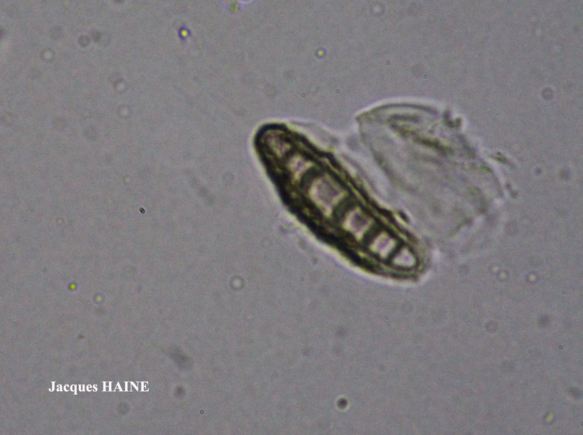
Jacques Haine - Source: http://www.lichensmaritimes.org/index.php?task=fiche&lichen=583&lang=en
France, Couvin
Jacques Haine - Source: http://www.lichensmaritimes.org/index.php?task=fiche&lichen=583&lang=en
France, Couvin

Jacques Haine - Source: http://www.lichensmaritimes.org/index.php?task=fiche&lichen=583&lang=en
France, Couvin
Jacques Haine - Source: http://www.lichensmaritimes.org/index.php?task=fiche&lichen=583&lang=en
France, Couvin

Jacques Haine - Source: http://www.lichensmaritimes.org/index.php?task=fiche&lichen=583&lang=en
France, Couvin

Jacques Haine - Source: http://www.lichensmaritimes.org/index.php?task=fiche&lichen=583&lang=en
France, Couvin

Jacques Haine - Source: http://www.lichensmaritimes.org/index.php?task=fiche&lichen=583&lang=en
France, Couvin
Jacques Haine - Source: http://www.lichensmaritimes.org/index.php?task=fiche&lichen=583&lang=en
France, Couvin
Jacques Haine - Source: http://www.lichensmaritimes.org/index.php?task=fiche&lichen=583&lang=en
France, Couvin
Jacques Haine - Source: http://www.lichensmaritimes.org/index.php?task=fiche&lichen=583&lang=en
France, Couvin
Ulrich Kirschbaum CC BY-SA 4.0 - Source: https://www.thm.de/lse/ulrich-kirschbaum/flechtenbilder
Central Europe; Germany: Hesse.(Coll/ident: Eichler/Cezanne).
Ulrich Kirschbaum CC BY-SA 4.0 - Source: https://www.thm.de/lse/ulrich-kirschbaum/flechtenbilder
Central Europe; Germany: Hesse.(Coll/ident: Eichler/Cezanne).
Ulrich Kirschbaum CC BY-SA 4.0 - Source: https://www.thm.de/lse/ulrich-kirschbaum/flechtenbilder
Central Europe; Germany: Hesse. (Coll/ident: Eichler/Cezanne).
Ulrich Kirschbaum CC BY-SA 4.0 - Source: https://www.thm.de/lse/ulrich-kirschbaum/flechtenbilder
Central Europe; Germany: Baden-Württemberg.
Ulrich Kirschbaum CC BY-SA 4.0 - Source: https://www.thm.de/lse/ulrich-kirschbaum/flechtenbilder
SE Europe; N-Cyprus; E of Girne; Beşparmak Mountains; between Kantara Village and Kantara Castle (picnic area); on Cupressus sempervirens
Ulrich Kirschbaum CC BY-SA 4.0 - Source: https://www.thm.de/lse/ulrich-kirschbaum/flechtenbilder
E Europe; N-Cyprus; SE of Girne; Beşparmak Mountains; between Alevkaya and Antiphonitis Monastery; on Pinus

Ulrich Kirschbaum CC BY-SA 4.0 - Source: https://www.thm.de/lse/ulrich-kirschbaum/flechtenbilder
E Europe; N-Cyprus; SE of Girne; Beşparmak Mountains; between Alevkaya and Antiphonitis Monastery; on Pinus
Ulrich Kirschbaum CC BY-SA 4.0 - Source: https://www.thm.de/lse/ulrich-kirschbaum/flechtenbilder
E Europe; N-Cyprus; SE of Girne; Beşparmak Mountains; between Alevkaya and Antiphonitis Monastery; on Pinus
Ulrich Kirschbaum CC BY-SA 4.0 - Source: https://www.thm.de/lse/ulrich-kirschbaum/flechtenbilder
E Europe; Cyprus; E of Girne: Besparma Mountains; on Cupressus
Marta Gonzalez Garcia - Centro de Estudios Micologicos Asturianos
Spain
Marta Gonzalez Garcia - Centro de Estudios Micologicos Asturianos
Spain
Marta Gonzalez Garcia - Centro de Estudios Micologicos Asturianos
Spain
Marta Gonzalez Garcia - Centro de Estudios Micologicos Asturianos
Spain
Marta Gonzalez Garcia - Centro de Estudios Micologicos Asturianos
Spain
Marta Gonzalez Garcia - Centro de Estudios Micologicos Asturianos
Spain
Marta Gonzalez Garcia - Centro de Estudios Micologicos Asturianos
Spain
Marta Gonzalez Garcia - Centro de Estudios Micologicos Asturianos
Spain
Felix Schumm - CC BY-SA 4.0
[ABL42207], Brazil, Alagoas, Quebrangulo, Pedra Talhada private
area. In Atlantic rain forest on tree bark. 9°15’ S, 36°25’35’’ W, 500-700
m. Leg. M. Cáceres & A. Aptroot (no 42207), 21-23.10.2017. Det. A.
Aptroot, 2017. - Spores 4-septate, 25 x 5 μm with 3μm gel.
Wolfgang von Brackel - CC BY-4.0
Germany, Bavaria, Friedergrieß
Wolfgang von Brackel - CC BY-4.0
Germany, Bavaria, Friedergrieß
Wolfgang von Brackel - CC BY-4.0
Germany, Bavaria, Ebensfeld
Wolfgang von Brackel - CC BY-4.0
Germany, Bavaria, Ebensfeld
Collezione lichenologica Abramo Massalongo del Museo di Storia Naturale G. Ligabue di Venezia - Autori: Seggi, Linda; Trabucco, Raffaella Proprietà: Fondazione Musei Civici di Venezia - CC BY-NC
Italy, Veneto, in op. Badia
as Opegrapha varia α lichenoides Schaer!
Collezione lichenologica Abramo Massalongo del Museo di Storia Naturale G. Ligabue di Venezia - Autori: Seggi, Linda; Trabucco, Raffaella Proprietà: Fondazione Musei Civici di Venezia - CC BY-NC
Italy, Veneto, in op. Badia
as Opegrapha varia α lichenoides Schaer!

Zahlbruckner A. 1926. Lichenes (Flechten). In: Engler A. (ed.): Die natürlichen Pflanzenfamilien. 2nd ed., vol 8, W. Engelmann, Leipzig, 270 pp.
Growth form: Crustose
Substrata: bark
Photobiont: Trentepohlia
Reproductive strategy: mainly sexual
Commonnes-rarity: (info)
Alpine belt: absent
Subalpine belt: extremely rare
Montane belt: very rare
Dry submediterranean belt: rare
Humid submediterranean belt: rather rare
Padanian area: extremely rare
pH of the substrata:
| 1 | 2 | 3 | 4 | 5 |
Solar irradiation:
| 1 | 2 | 3 | 4 | 5 |
Aridity:
| 1 | 2 | 3 | 4 | 5 |
Eutrophication:
| 1 | 2 | 3 | 4 | 5 |
Poleotolerance:
| 0 | 1 | 2 | 3 |
Altitudinal distribution:
| 1 | 2 | 3 | 4 | 5 | 6 |
Rarity
absent
extremely rare
very rare
rare
rather rare
rather common
common
very common
extremely common
Loading data...
Occurrence data
Predictive map
Walter Obermayer CC BY-SA 4.0 - Source: Lichens of Noricum - http://lichens-of-noricum.uni-graz.at/

P.L. Nimis; Owner: Department of Life Sciences, University of Trieste
Herbarium: TSB (7615)
2001/11/27
P.L. Nimis; Owner: Department of Life Sciences, University of Trieste
Herbarium: TSB (7615)
2001/11/27

P.L. Nimis; Owner: Department of Life Sciences, University of Trieste
Herbarium: TSB (19647)
2001/11/27
P.L. Nimis; Owner: Department of Life Sciences, University of Trieste
Herbarium: TSB (19647)
2001/11/27
Andres Saag; Owner: University of Tartu
Juri Nascimbene; Owner: Department of Life Sciences, University of Trieste
Italy, Trentino-Alto Adige, Trento, Villa Welsperg, Centro Visitatori del Parco di Paneveggio; altitude: 1030 m
03.04.2009

Juri Nascimbene; Owner: Department of Life Sciences, University of Trieste
Italy, Trentino-Alto Adige, Trento, Villa Welsperg, Centro Visitatori del Parco di Paneveggio; altitude: 1030 m
03.04.2009
Juri Nascimbene; Owner: Department of Life Sciences, University of Trieste
Italy, Trentino-Alto Adige, Trento, Villa Welsperg, Centro Visitatori del Parco di Paneveggio; altitude: 1030 m
03.04.2009
Juri Nascimbene; Owner: Department of Life Sciences, University of Trieste
Italy, Trentino-Alto Adige, Trento, Villa Welsperg, Centro Visitatori del Parco di Paneveggio; altitude: 1030 m
03.04.2009
Domenico Puntillo; Owner: Domenico Puntillo
Italy

Domenico Puntillo; Owner: Domenico Puntillo
Italy
Domenico Puntillo; Owner: Domenico Puntillo
Italy

Curtis Randall Björk, - CC BY-SA 4.0
Campus of Royal Roads University, Victoria, British Columbia, Canada Canada
2017
Felix Schumm – CC BY-SA 4.0
[1030], Gemany, Baden-Württemberg, Schwäbische Alb, Kreis Heidenheim, im Wental an Laubbäumen, ca 600 m. TK: 7226. Leg. F. Schumm 04.1967, det. F. Schumm.

Felix Schumm – CC BY-SA 4.0
[1030], Gemany, Baden-Württemberg, Schwäbische Alb, Kreis Heidenheim, im Wental an Laubbäumen, ca 600 m. TK: 7226. Leg. F. Schumm 04.1967, det. F. Schumm.
Felix Schumm – CC BY-SA 4.0
[1030], Gemany, Baden-Württemberg, Schwäbische Alb, Kreis Heidenheim, im Wental an Laubbäumen, ca 600 m. TK: 7226. Leg. F. Schumm 04.1967, det. F. Schumm.

Felix Schumm – CC BY-SA 4.0
[1030], Gemany, Baden-Württemberg, Schwäbische Alb, Kreis Heidenheim, im Wental an Laubbäumen, ca 600 m. TK: 7226. Leg. F. Schumm 04.1967, det. F. Schumm.

Felix Schumm – CC BY-SA 4.0
[1030], Gemany, Baden-Württemberg, Schwäbische Alb, Kreis Heidenheim, im Wental an Laubbäumen, ca 600 m. TK: 7226. Leg. F. Schumm 04.1967, det. F. Schumm.
Felix Schumm – CC BY-SA 4.0
[1030], Gemany, Baden-Württemberg, Schwäbische Alb, Kreis Heidenheim, im Wental an Laubbäumen, ca 600 m. TK: 7226. Leg. F. Schumm 04.1967, det. F. Schumm.
Felix Schumm – CC BY-SA 4.0
[6967], Germany, Baden-Württemberg, Rems-Murr-Kreis, 5 km westlich von Welzheim im Rotal, Stubensandsteingebiet, an Eiche, luftfeucht; 440 m, TK: 7124/NW. Leg. Schumm & Schwarz 23.04.2000, det. F. Schumm 2007
Felix Schumm – CC BY-SA 4.0
[6967], Germany, Baden-Württemberg, Rems-Murr-Kreis, 5 km westlich von Welzheim im Rotal, Stubensandsteingebiet, an Eiche, luftfeucht; 440 m, TK: 7124/NW. Leg. Schumm & Schwarz 23.04.2000, det. F. Schumm 2007

Felix Schumm – CC BY-SA 4.0
[6967], Germany, Baden-Württemberg, Rems-Murr-Kreis, 5 km westlich von Welzheim im Rotal, Stubensandsteingebiet, an Eiche, luftfeucht; 440 m, TK: 7124/NW. Leg. Schumm & Schwarz 23.04.2000, det. F. Schumm 2007
Felix Schumm – CC BY-SA 4.0
[6967], Germany, Baden-Württemberg, Rems-Murr-Kreis, 5 km westlich von Welzheim im Rotal, Stubensandsteingebiet, an Eiche, luftfeucht; 440 m, TK: 7124/NW. Leg. Schumm & Schwarz 23.04.2000, det. F. Schumm 2007

Felix Schumm – CC BY-SA 4.0
[6967], Germany, Baden-Württemberg, Rems-Murr-Kreis, 5 km westlich von Welzheim im Rotal, Stubensandsteingebiet, an Eiche, luftfeucht; 440 m, TK: 7124/NW. Leg. Schumm & Schwarz 23.04.2000, det. F. Schumm 2007

Felix Schumm – CC BY-SA 4.0
[6967], Germany, Baden-Württemberg, Rems-Murr-Kreis, 5 km westlich von Welzheim im Rotal, Stubensandsteingebiet, an Eiche, luftfeucht; 440 m, TK: 7124/NW. Leg. Schumm & Schwarz 23.04.2000, det. F. Schumm 2007
Felix Schumm – CC BY-SA 4.0
[6967], Germany, Baden-Württemberg, Rems-Murr-Kreis, 5 km westlich von Welzheim im Rotal, Stubensandsteingebiet, an Eiche, luftfeucht; 440 m, TK: 7124/NW. Leg. Schumm & Schwarz 23.04.2000, det. F. Schumm 2007
Felix Schumm – CC BY-SA 4.0
[6967], Germany, Baden-Württemberg, Rems-Murr-Kreis, 5 km westlich von Welzheim im Rotal, Stubensandsteingebiet, an Eiche, luftfeucht; 440 m, TK: 7124/NW. Leg. Schumm & Schwarz 23.04.2000, det. F. Schumm 2007
Felix Schumm – CC BY-SA 4.0
[6967], Germany, Baden-Württemberg, Rems-Murr-Kreis, 5 km westlich von Welzheim im Rotal, Stubensandsteingebiet, an Eiche, luftfeucht; 440 m, TK: 7124/NW. Leg. Schumm & Schwarz 23.04.2000, det. F. Schumm 2007
Felix Schumm – CC BY-SA 4.0
[6967], Germany, Baden-Württemberg, Rems-Murr-Kreis, 5 km westlich von Welzheim im Rotal, Stubensandsteingebiet, an Eiche, luftfeucht; 440 m, TK: 7124/NW. Leg. Schumm & Schwarz 23.04.2000, det. F. Schumm 2007

Felix Schumm – CC BY-SA 4.0
[6967], Germany, Baden-Württemberg, Rems-Murr-Kreis, 5 km westlich von Welzheim im Rotal, Stubensandsteingebiet, an Eiche, luftfeucht; 440 m, TK: 7124/NW. Leg. Schumm & Schwarz 23.04.2000, det. F. Schumm 2007
Felix Schumm – CC BY-SA 4.0
[6967], Germany, Baden-Württemberg, Rems-Murr-Kreis, 5 km westlich von Welzheim im Rotal, Stubensandsteingebiet, an Eiche, luftfeucht; 440 m, TK: 7124/NW. Leg. Schumm & Schwarz 23.04.2000, det. F. Schumm 2007
Felix Schumm – CC BY-SA 4.0
[13631], Germany, Baden-Württemberg, Kreis Göppingen, südwestlich von Adelberg nahe dem Herrenbachstausee, Buhwiesenweg, corticol im Mischwald, ca. 48°44'N, 9°33'E, 412 m. Leg. Schumm 08.02.2008

Felix Schumm – CC BY-SA 4.0
[13631], Germany, Baden-Württemberg, Kreis Göppingen, südwestlich von Adelberg nahe dem Herrenbachstausee, Buhwiesenweg, corticol im Mischwald, ca. 48°44'N, 9°33'E, 412 m. Leg. Schumm 08.02.2008

Felix Schumm – CC BY-SA 4.0
[13631], Germany, Baden-Württemberg, Kreis Göppingen, südwestlich von Adelberg nahe dem Herrenbachstausee, Buhwiesenweg, corticol im Mischwald, ca. 48°44'N, 9°33'E, 412 m. Leg. Schumm 08.02.2008

Felix Schumm – CC BY-SA 4.0
[13631], Germany, Baden-Württemberg, Kreis Göppingen, südwestlich von Adelberg nahe dem Herrenbachstausee, Buhwiesenweg, corticol im Mischwald, ca. 48°44'N, 9°33'E, 412 m. Leg. Schumm 08.02.2008

Felix Schumm – CC BY-SA 4.0
[13631], Germany, Baden-Württemberg, Kreis Göppingen, südwestlich von Adelberg nahe dem Herrenbachstausee, Buhwiesenweg, corticol im Mischwald, ca. 48°44'N, 9°33'E, 412 m. Leg. Schumm 08.02.2008
Felix Schumm – CC BY-SA 4.0
[16464], GERMANY, Baden-Württemberg, Kreis Göppingen, im Herrenbachtal zwischen Rechberghausen und der Zachersmühle, 48.74100°N, 9.62803° E, 330 m. Leg. Schumm 11.04.2010.

Felix Schumm – CC BY-SA 4.0
[16464], GERMANY, Baden-Württemberg, Kreis Göppingen, im Herrenbachtal zwischen Rechberghausen und der Zachersmühle, 48.74100°N, 9.62803° E, 330 m. Leg. Schumm 11.04.2010.
Felix Schumm – CC BY-SA 4.0
[16464], GERMANY, Baden-Württemberg, Kreis Göppingen, im Herrenbachtal zwischen Rechberghausen und der Zachersmühle, 48.74100°N, 9.62803° E, 330 m. Leg. Schumm 11.04.2010.

Felix Schumm – CC BY-SA 4.0
[16464], GERMANY, Baden-Württemberg, Kreis Göppingen, im Herrenbachtal zwischen Rechberghausen und der Zachersmühle, 48.74100°N, 9.62803° E, 330 m. Leg. Schumm 11.04.2010.
Felix Schumm – CC BY-SA 4.0
[18569], Germany, Rheinland-Pfalz, Kreis Kaiserslautern, Pfälzer Wald, Karlstal südwestlich von Trippstadt, 300-350 m, Buntsandsteingebiet, Schluchtwald (Luzulo-Fagetum), an Fagus sylvatica. Leg. Schumm & Lauer 10.06.1978, det. Schumm.
Felix Schumm – CC BY-SA 4.0
[18569], Germany, Rheinland-Pfalz, Kreis Kaiserslautern, Pfälzer Wald, Karlstal südwestlich von Trippstadt, 300-350 m, Buntsandsteingebiet, Schluchtwald (Luzulo-Fagetum), an Fagus sylvatica. Leg. Schumm & Lauer 10.06.1978, det. Schumm.
Felix Schumm – CC BY-SA 4.0
[18569], Germany, Rheinland-Pfalz, Kreis Kaiserslautern, Pfälzer Wald, Karlstal südwestlich von Trippstadt, 300-350 m, Buntsandsteingebiet, Schluchtwald (Luzulo-Fagetum), an Fagus sylvatica. Leg. Schumm & Lauer 10.06.1978, det. Schumm.

Felix Schumm – CC BY-SA 4.0
[18569], Germany, Rheinland-Pfalz, Kreis Kaiserslautern, Pfälzer Wald, Karlstal südwestlich von Trippstadt, 300-350 m, Buntsandsteingebiet, Schluchtwald (Luzulo-Fagetum), an Fagus sylvatica. Leg. Schumm & Lauer 10.06.1978, det. Schumm.
Felix Schumm – CC BY-SA 4.0
[18569], Germany, Rheinland-Pfalz, Kreis Kaiserslautern, Pfälzer Wald, Karlstal südwestlich von Trippstadt, 300-350 m, Buntsandsteingebiet, Schluchtwald (Luzulo-Fagetum), an Fagus sylvatica. Leg. Schumm & Lauer 10.06.1978, det. Schumm.
Felix Schumm – CC BY-SA 4.0
[18569], Germany, Rheinland-Pfalz, Kreis Kaiserslautern, Pfälzer Wald, Karlstal südwestlich von Trippstadt, 300-350 m, Buntsandsteingebiet, Schluchtwald (Luzulo-Fagetum), an Fagus sylvatica. Leg. Schumm & Lauer 10.06.1978, det. Schumm.
Felix Schumm – CC BY-SA 4.0
[18569], Germany, Rheinland-Pfalz, Kreis Kaiserslautern, Pfälzer Wald, Karlstal südwestlich von Trippstadt, 300-350 m, Buntsandsteingebiet, Schluchtwald (Luzulo-Fagetum), an Fagus sylvatica. Leg. Schumm & Lauer 10.06.1978, det. Schumm.
Felix Schumm – CC BY-SA 4.0
[18569], Germany, Rheinland-Pfalz, Kreis Kaiserslautern, Pfälzer Wald, Karlstal südwestlich von Trippstadt, 300-350 m, Buntsandsteingebiet, Schluchtwald (Luzulo-Fagetum), an Fagus sylvatica. Leg. Schumm & Lauer 10.06.1978, det. Schumm.

Felix Schumm – CC BY-SA 4.0
[18569], Germany, Rheinland-Pfalz, Kreis Kaiserslautern, Pfälzer Wald, Karlstal südwestlich von Trippstadt, 300-350 m, Buntsandsteingebiet, Schluchtwald (Luzulo-Fagetum), an Fagus sylvatica. Leg. Schumm & Lauer 10.06.1978, det. Schumm.

Felix Schumm – CC BY-SA 4.0
[18569], Germany, Rheinland-Pfalz, Kreis Kaiserslautern, Pfälzer Wald, Karlstal südwestlich von Trippstadt, 300-350 m, Buntsandsteingebiet, Schluchtwald (Luzulo-Fagetum), an Fagus sylvatica. Leg. Schumm & Lauer 10.06.1978, det. Schumm.
Felix Schumm – CC BY-SA 4.0
[18569], Germany, Rheinland-Pfalz, Kreis Kaiserslautern, Pfälzer Wald, Karlstal südwestlich von Trippstadt, 300-350 m, Buntsandsteingebiet, Schluchtwald (Luzulo-Fagetum), an Fagus sylvatica. Leg. Schumm & Lauer 10.06.1978, det. Schumm.

Felix Schumm – CC BY-SA 4.0
[18569], Germany, Rheinland-Pfalz, Kreis Kaiserslautern, Pfälzer Wald, Karlstal südwestlich von Trippstadt, 300-350 m, Buntsandsteingebiet, Schluchtwald (Luzulo-Fagetum), an Fagus sylvatica. Leg. Schumm & Lauer 10.06.1978, det. Schumm.

Felix Schumm – CC BY-SA 4.0
[18569], Germany, Rheinland-Pfalz, Kreis Kaiserslautern, Pfälzer Wald, Karlstal südwestlich von Trippstadt, 300-350 m, Buntsandsteingebiet, Schluchtwald (Luzulo-Fagetum), an Fagus sylvatica. Leg. Schumm & Lauer 10.06.1978, det. Schumm.

Felix Schumm – CC BY-SA 4.0
[18569], Germany, Rheinland-Pfalz, Kreis Kaiserslautern, Pfälzer Wald, Karlstal südwestlich von Trippstadt, 300-350 m, Buntsandsteingebiet, Schluchtwald (Luzulo-Fagetum), an Fagus sylvatica. Leg. Schumm & Lauer 10.06.1978, det. Schumm.
Felix Schumm – CC BY-SA 4.0
[18569], Germany, Rheinland-Pfalz, Kreis Kaiserslautern, Pfälzer Wald, Karlstal südwestlich von Trippstadt, 300-350 m, Buntsandsteingebiet, Schluchtwald (Luzulo-Fagetum), an Fagus sylvatica. Leg. Schumm & Lauer 10.06.1978, det. Schumm.
Felix Schumm – CC BY-SA 4.0
[18569], Germany, Rheinland-Pfalz, Kreis Kaiserslautern, Pfälzer Wald, Karlstal südwestlich von Trippstadt, 300-350 m, Buntsandsteingebiet, Schluchtwald (Luzulo-Fagetum), an Fagus sylvatica. Leg. Schumm & Lauer 10.06.1978, det. Schumm.

Pier Luigi Nimis - CC BY-SA 4.0
TSB 42159

Pier Luigi Nimis - CC BY-SA 4.0
TSB 42159

Pier Luigi Nimis - CC BY-SA 4.0
TSB 42159

Pier Luigi Nimis - CC BY-SA 4.0
TSB 38779
Leif Stridvall - Source: http://www.stridvall.se/la/galleries.php
Jacques Haine - Source: http://www.lichensmaritimes.org/index.php?task=fiche&lichen=583&lang=en
France, Couvin
Jacques Haine - Source: http://www.lichensmaritimes.org/index.php?task=fiche&lichen=583&lang=en
France, Couvin
Jacques Haine - Source: http://www.lichensmaritimes.org/index.php?task=fiche&lichen=583&lang=en
France, Couvin

Jacques Haine - Source: http://www.lichensmaritimes.org/index.php?task=fiche&lichen=583&lang=en
France, Couvin
Jacques Haine - Source: http://www.lichensmaritimes.org/index.php?task=fiche&lichen=583&lang=en
France, Couvin
Jacques Haine - Source: http://www.lichensmaritimes.org/index.php?task=fiche&lichen=583&lang=en
France, Couvin
Jacques Haine - Source: http://www.lichensmaritimes.org/index.php?task=fiche&lichen=583&lang=en
France, Couvin
Jacques Haine - Source: http://www.lichensmaritimes.org/index.php?task=fiche&lichen=583&lang=en
France, Couvin

Jacques Haine - Source: http://www.lichensmaritimes.org/index.php?task=fiche&lichen=583&lang=en
France, Couvin

Jacques Haine - Source: http://www.lichensmaritimes.org/index.php?task=fiche&lichen=583&lang=en
France, Couvin

Ulrich Kirschbaum CC BY-SA 4.0 - Source: https://www.thm.de/lse/ulrich-kirschbaum/flechtenbilder
Central Europe; Germany: Hesse.(Coll/ident: Eichler/Cezanne).
Ulrich Kirschbaum CC BY-SA 4.0 - Source: https://www.thm.de/lse/ulrich-kirschbaum/flechtenbilder
Central Europe; Germany: Hesse.(Coll/ident: Eichler/Cezanne).
Ulrich Kirschbaum CC BY-SA 4.0 - Source: https://www.thm.de/lse/ulrich-kirschbaum/flechtenbilder
Central Europe; Germany: Hesse. (Coll/ident: Eichler/Cezanne).

Ulrich Kirschbaum CC BY-SA 4.0 - Source: https://www.thm.de/lse/ulrich-kirschbaum/flechtenbilder
Central Europe; Germany: Baden-Württemberg.

Ulrich Kirschbaum CC BY-SA 4.0 - Source: https://www.thm.de/lse/ulrich-kirschbaum/flechtenbilder
SE Europe; N-Cyprus; E of Girne; Beşparmak Mountains; between Kantara Village and Kantara Castle (picnic area); on Cupressus sempervirens

Ulrich Kirschbaum CC BY-SA 4.0 - Source: https://www.thm.de/lse/ulrich-kirschbaum/flechtenbilder
E Europe; N-Cyprus; SE of Girne; Beşparmak Mountains; between Alevkaya and Antiphonitis Monastery; on Pinus

Ulrich Kirschbaum CC BY-SA 4.0 - Source: https://www.thm.de/lse/ulrich-kirschbaum/flechtenbilder
E Europe; N-Cyprus; SE of Girne; Beşparmak Mountains; between Alevkaya and Antiphonitis Monastery; on Pinus

Ulrich Kirschbaum CC BY-SA 4.0 - Source: https://www.thm.de/lse/ulrich-kirschbaum/flechtenbilder
E Europe; N-Cyprus; SE of Girne; Beşparmak Mountains; between Alevkaya and Antiphonitis Monastery; on Pinus

Ulrich Kirschbaum CC BY-SA 4.0 - Source: https://www.thm.de/lse/ulrich-kirschbaum/flechtenbilder
E Europe; Cyprus; E of Girne: Besparma Mountains; on Cupressus

Marta Gonzalez Garcia - Centro de Estudios Micologicos Asturianos
Spain

Marta Gonzalez Garcia - Centro de Estudios Micologicos Asturianos
Spain

Marta Gonzalez Garcia - Centro de Estudios Micologicos Asturianos
Spain

Marta Gonzalez Garcia - Centro de Estudios Micologicos Asturianos
Spain

Marta Gonzalez Garcia - Centro de Estudios Micologicos Asturianos
Spain

Marta Gonzalez Garcia - Centro de Estudios Micologicos Asturianos
Spain

Marta Gonzalez Garcia - Centro de Estudios Micologicos Asturianos
Spain

Marta Gonzalez Garcia - Centro de Estudios Micologicos Asturianos
Spain

Felix Schumm - CC BY-SA 4.0
[ABL42207], Brazil, Alagoas, Quebrangulo, Pedra Talhada private area. In Atlantic rain forest on tree bark. 9°15’ S, 36°25’35’’ W, 500-700 m. Leg. M. Cáceres & A. Aptroot (no 42207), 21-23.10.2017. Det. A. Aptroot, 2017. - Spores 4-septate, 25 x 5 μm with 3μm gel.

Wolfgang von Brackel - CC BY-4.0
Germany, Bavaria, Friedergrieß

Wolfgang von Brackel - CC BY-4.0
Germany, Bavaria, Friedergrieß

Wolfgang von Brackel - CC BY-4.0
Germany, Bavaria, Ebensfeld

Wolfgang von Brackel - CC BY-4.0
Germany, Bavaria, Ebensfeld

Collezione lichenologica Abramo Massalongo del Museo di Storia Naturale G. Ligabue di Venezia - Autori: Seggi, Linda; Trabucco, Raffaella Proprietà: Fondazione Musei Civici di Venezia - CC BY-NC
Italy, Veneto, in op. Badia
as Opegrapha varia α lichenoides Schaer!

Collezione lichenologica Abramo Massalongo del Museo di Storia Naturale G. Ligabue di Venezia - Autori: Seggi, Linda; Trabucco, Raffaella Proprietà: Fondazione Musei Civici di Venezia - CC BY-NC
Italy, Veneto, in op. Badia
as Opegrapha varia α lichenoides Schaer!