
Cladonia rangiformis Hoffm.
Deutschl. Fl., 2: 114, 1796, nom. cons.
Synonyms: Cladonia aberrans (Abbayes) Klement nom.inval.; Cladonia klementii Oxner nom. inval.; Cladonia muricata (Delise) Rabenh.; Cladonia muricata f. euganea A. Massal.; Cladonia rangiformis var. muricata (Delise) Arnold; Cladonia rangiformis var. pungens (Ach.) Vain.; Cladonia rangiformis var. sorediophora (Nyl.) Vain.
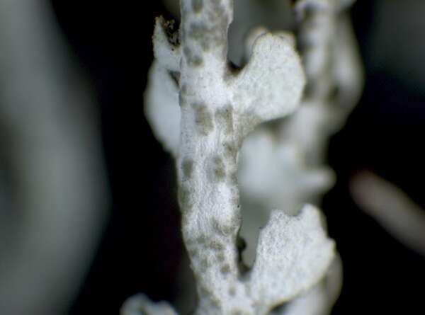
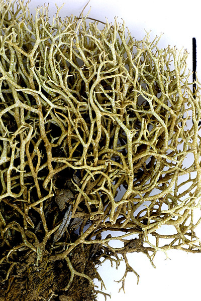
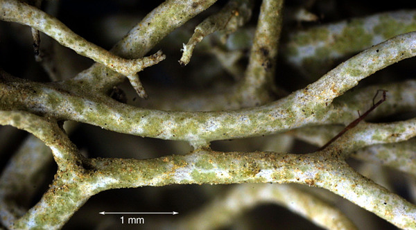
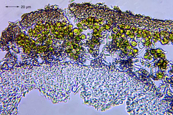
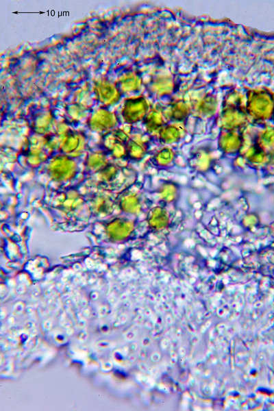
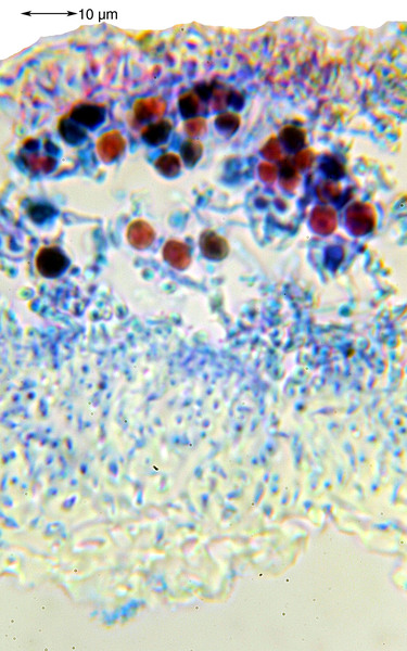
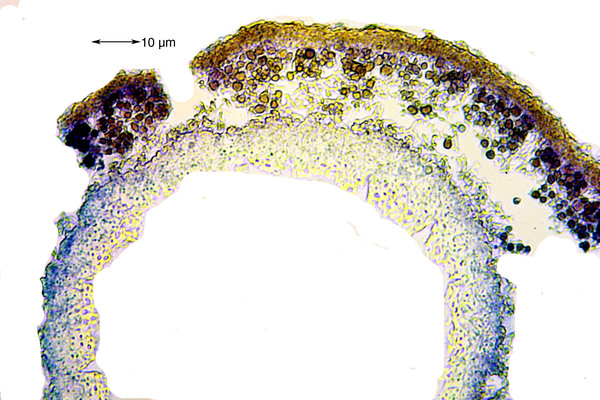
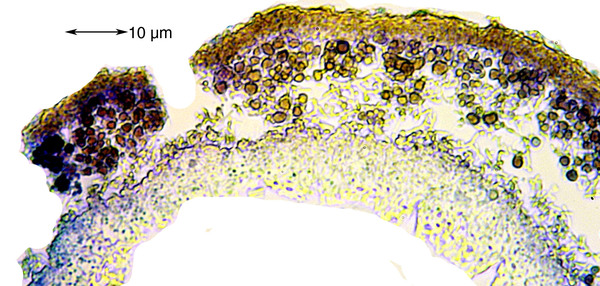
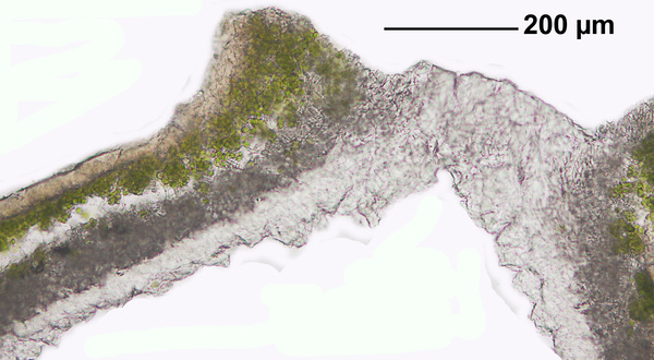
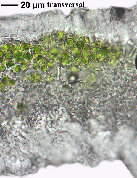
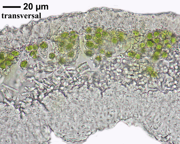
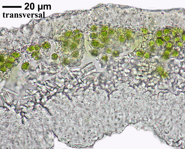
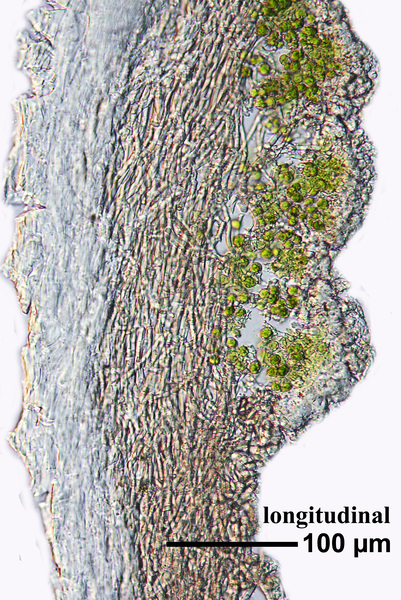
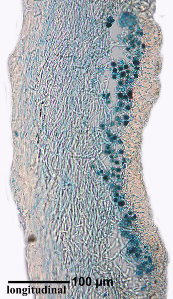
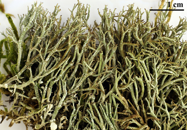
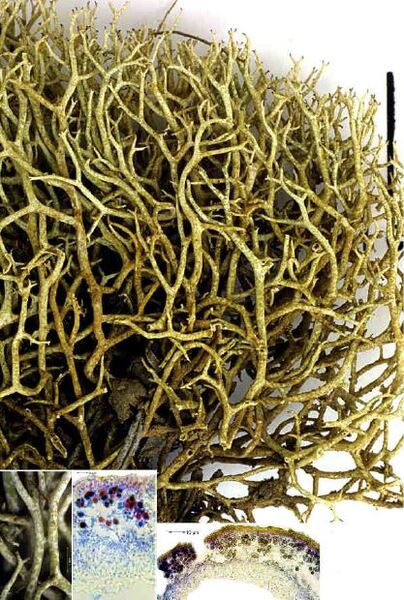
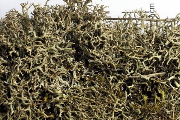
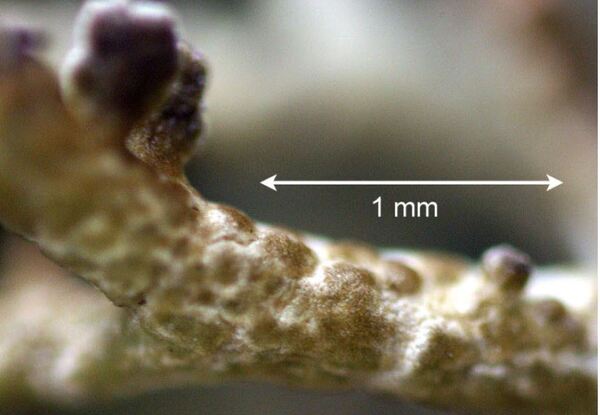
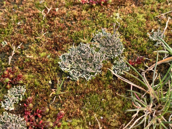
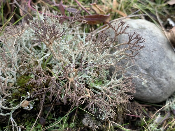
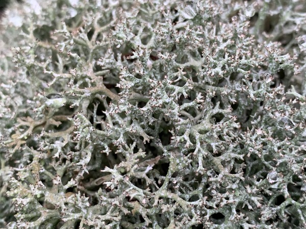
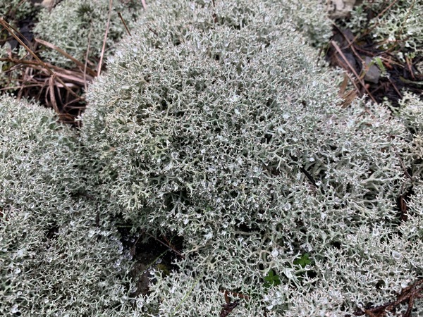
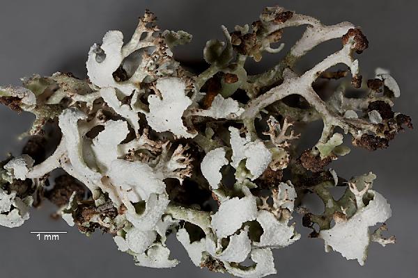
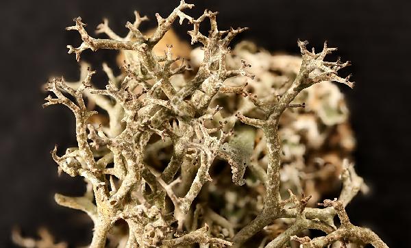
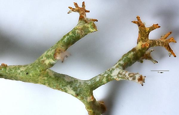
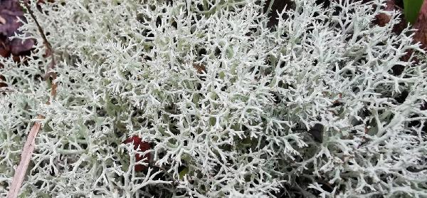
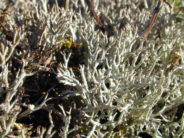
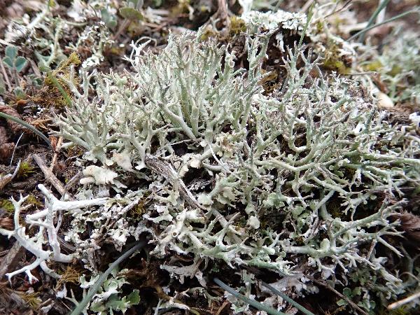
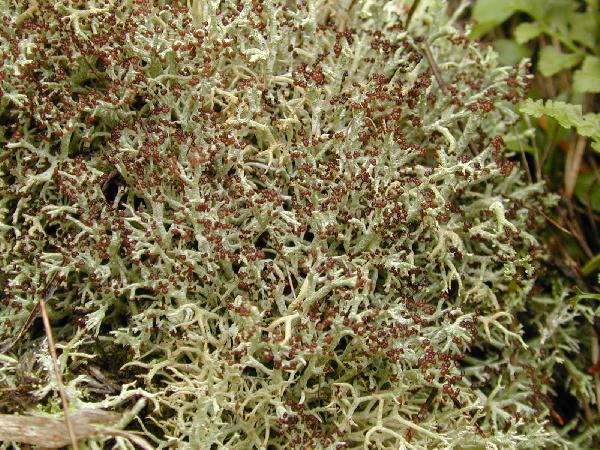
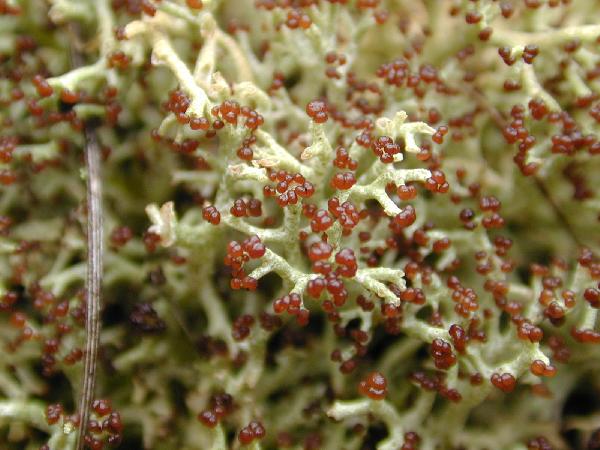
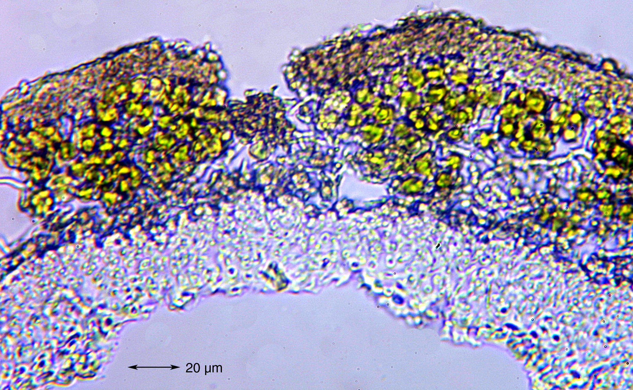
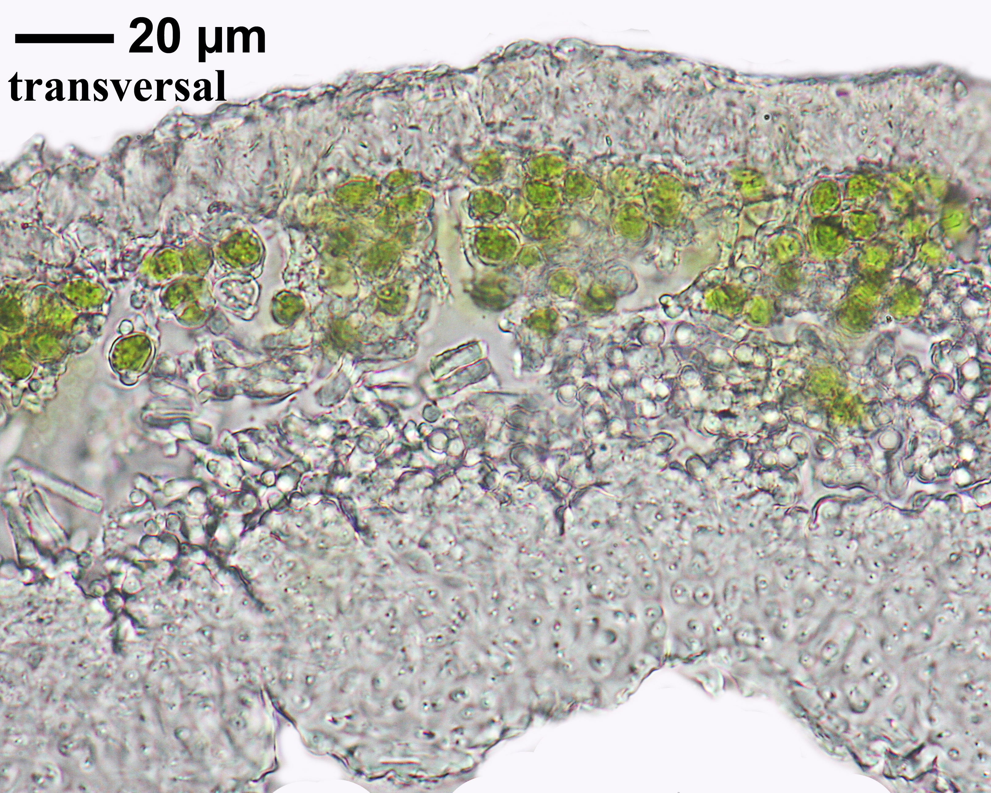
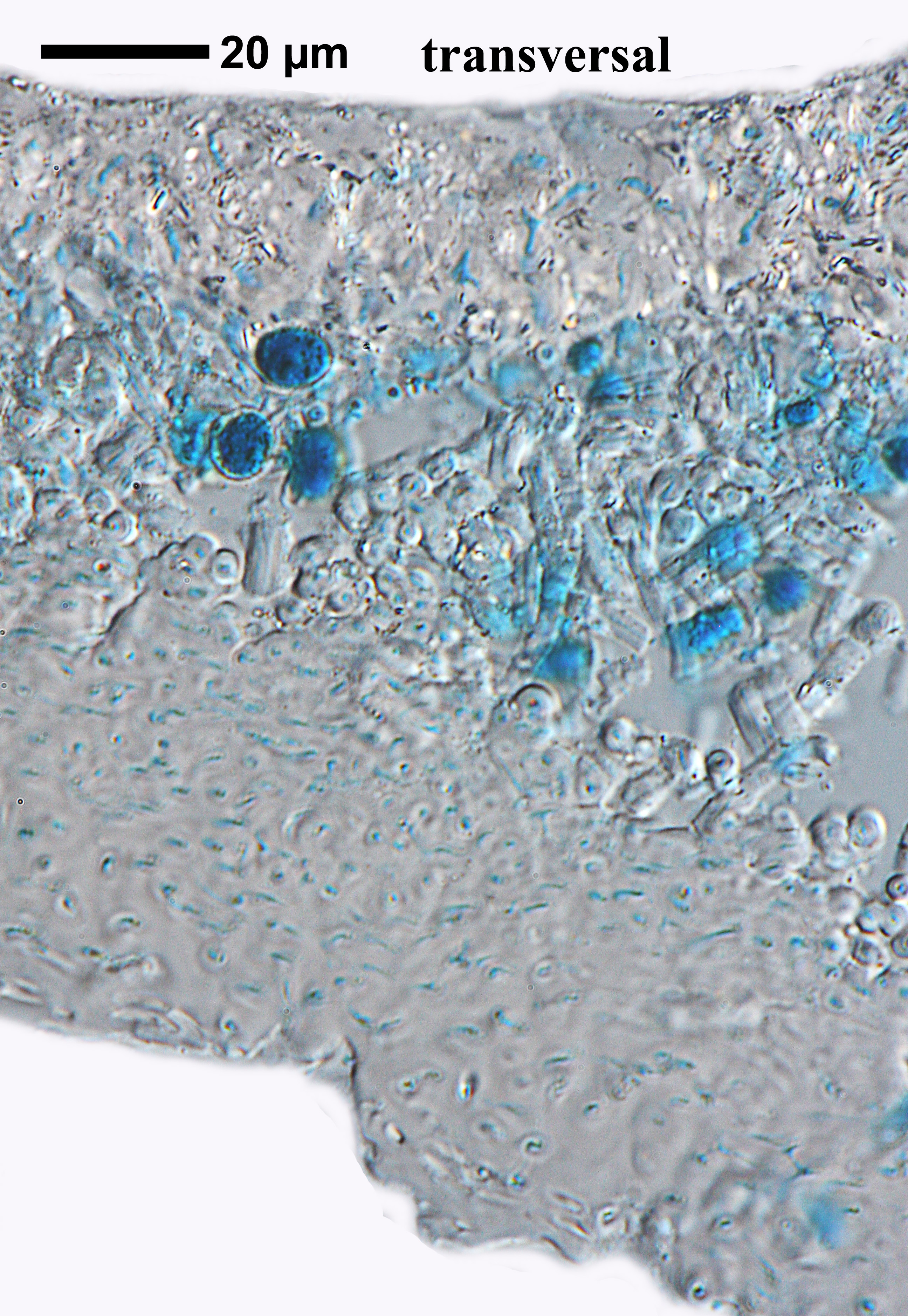
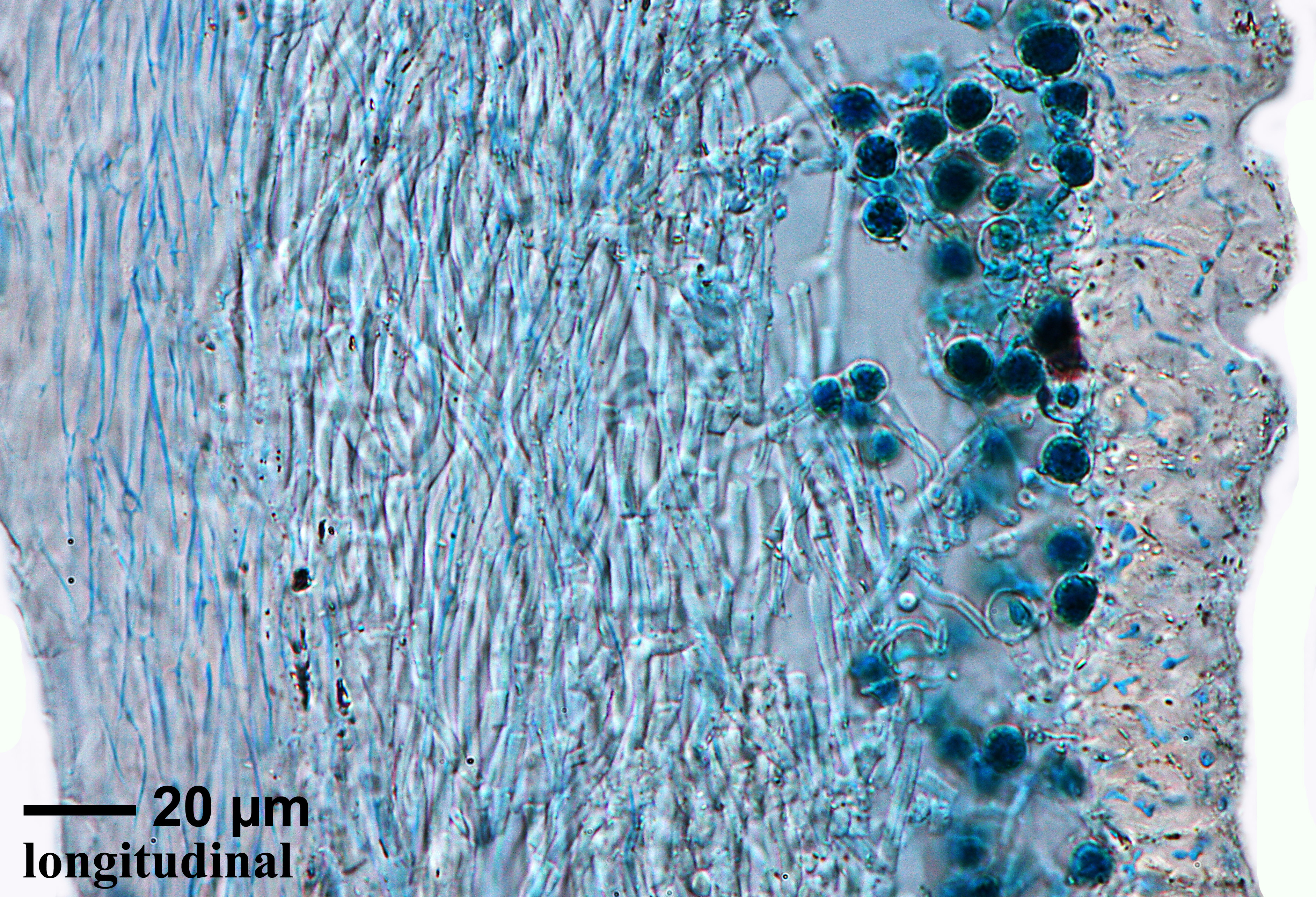
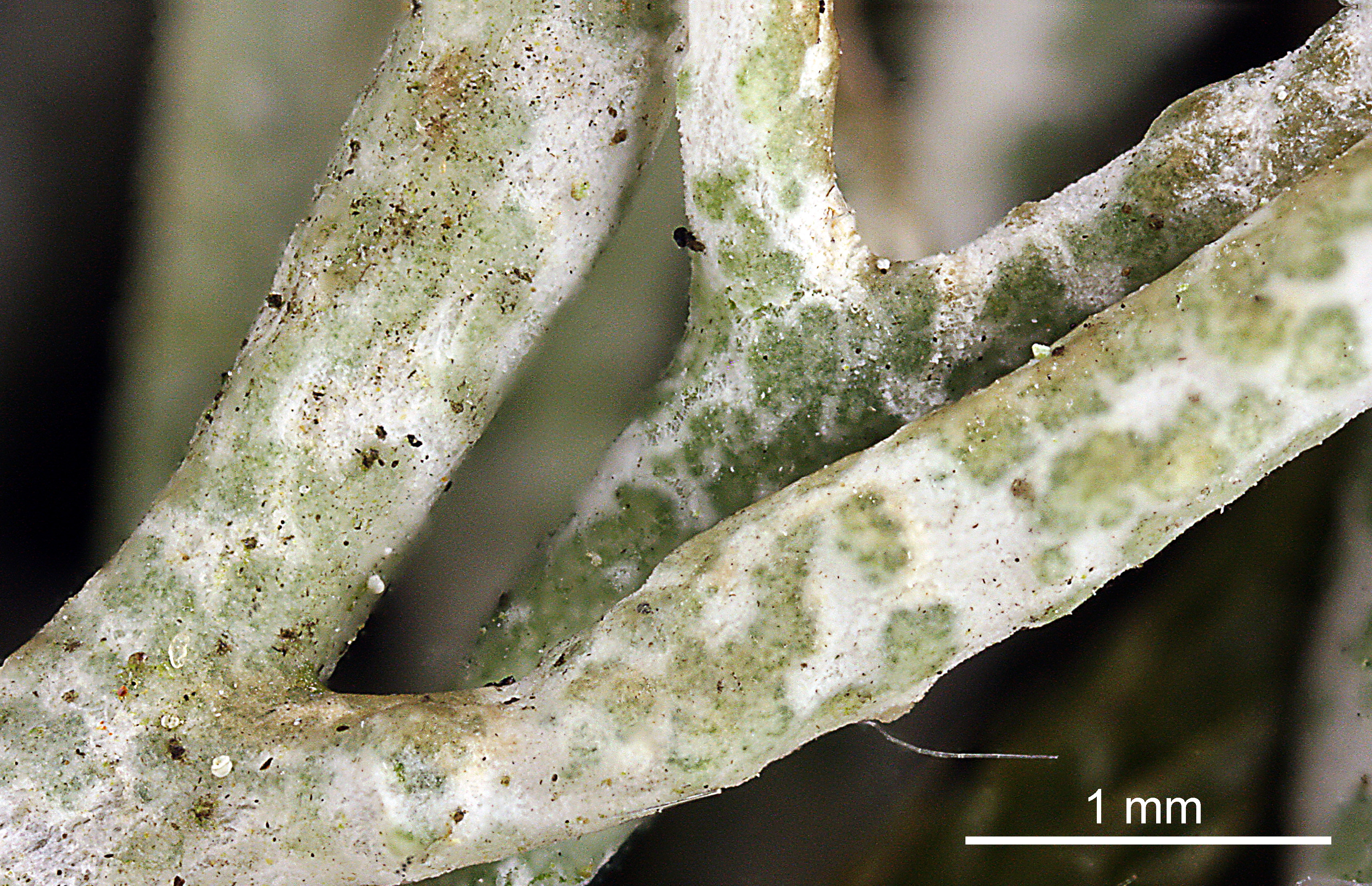
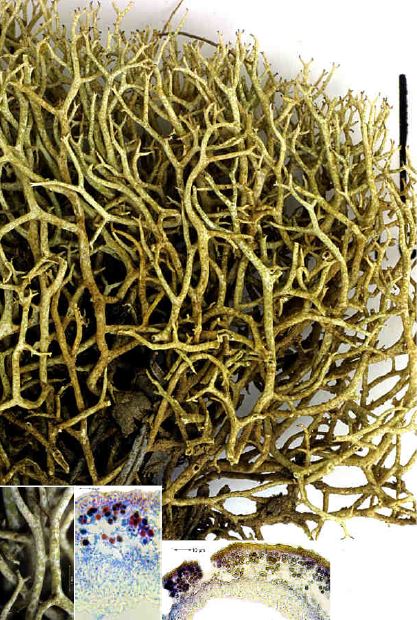
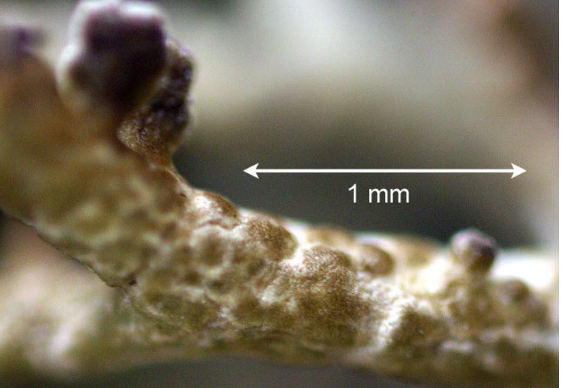
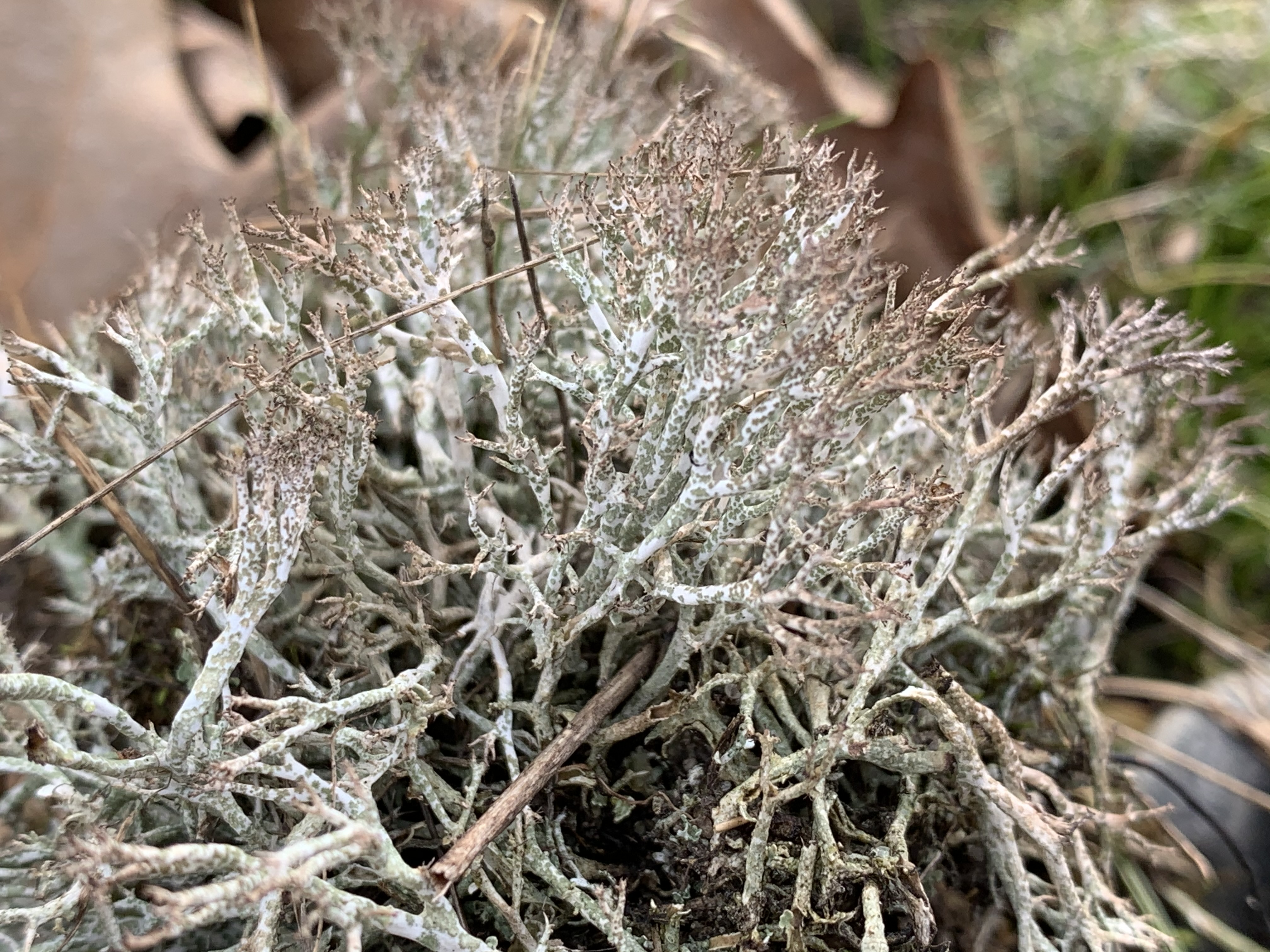
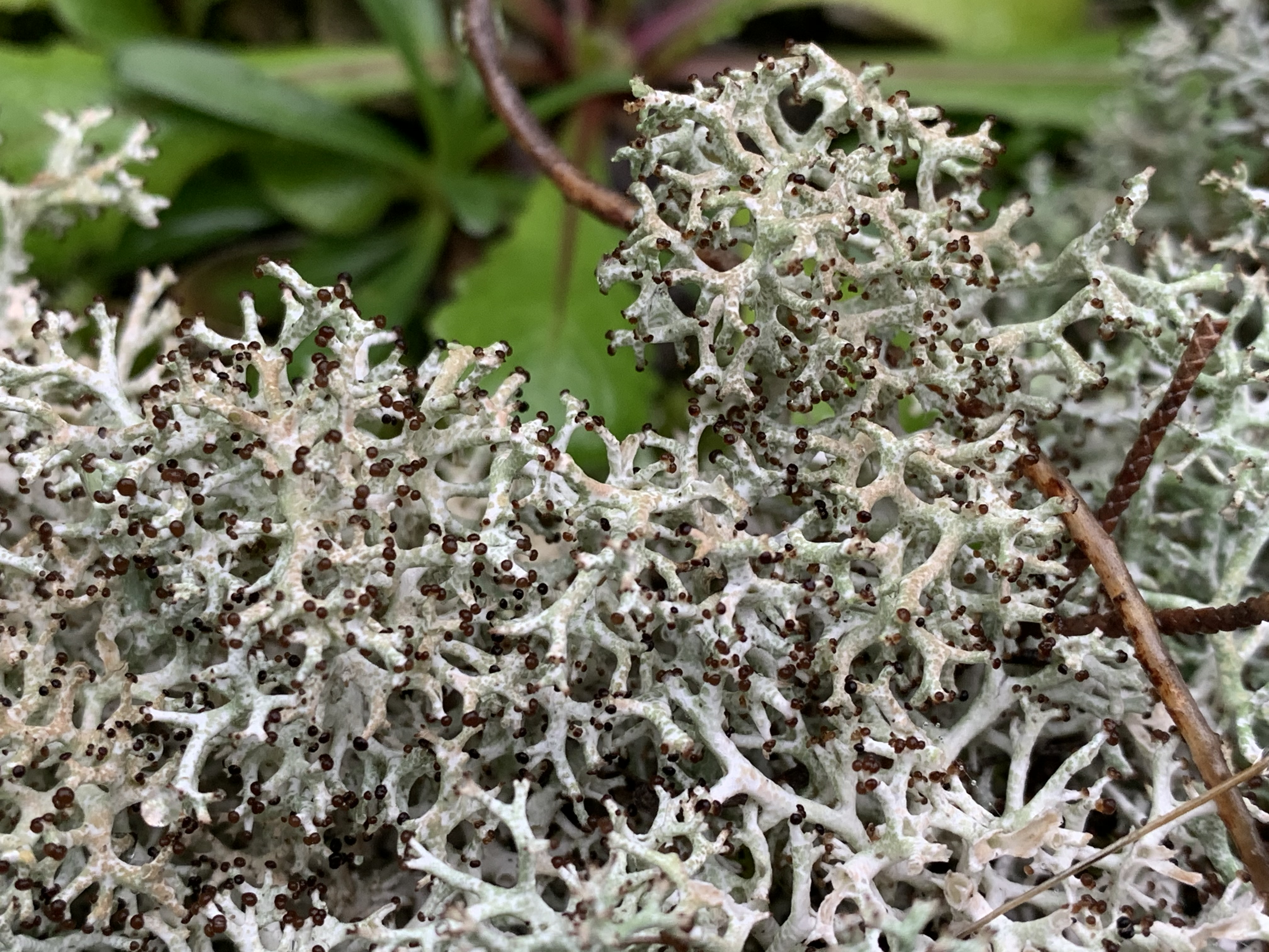
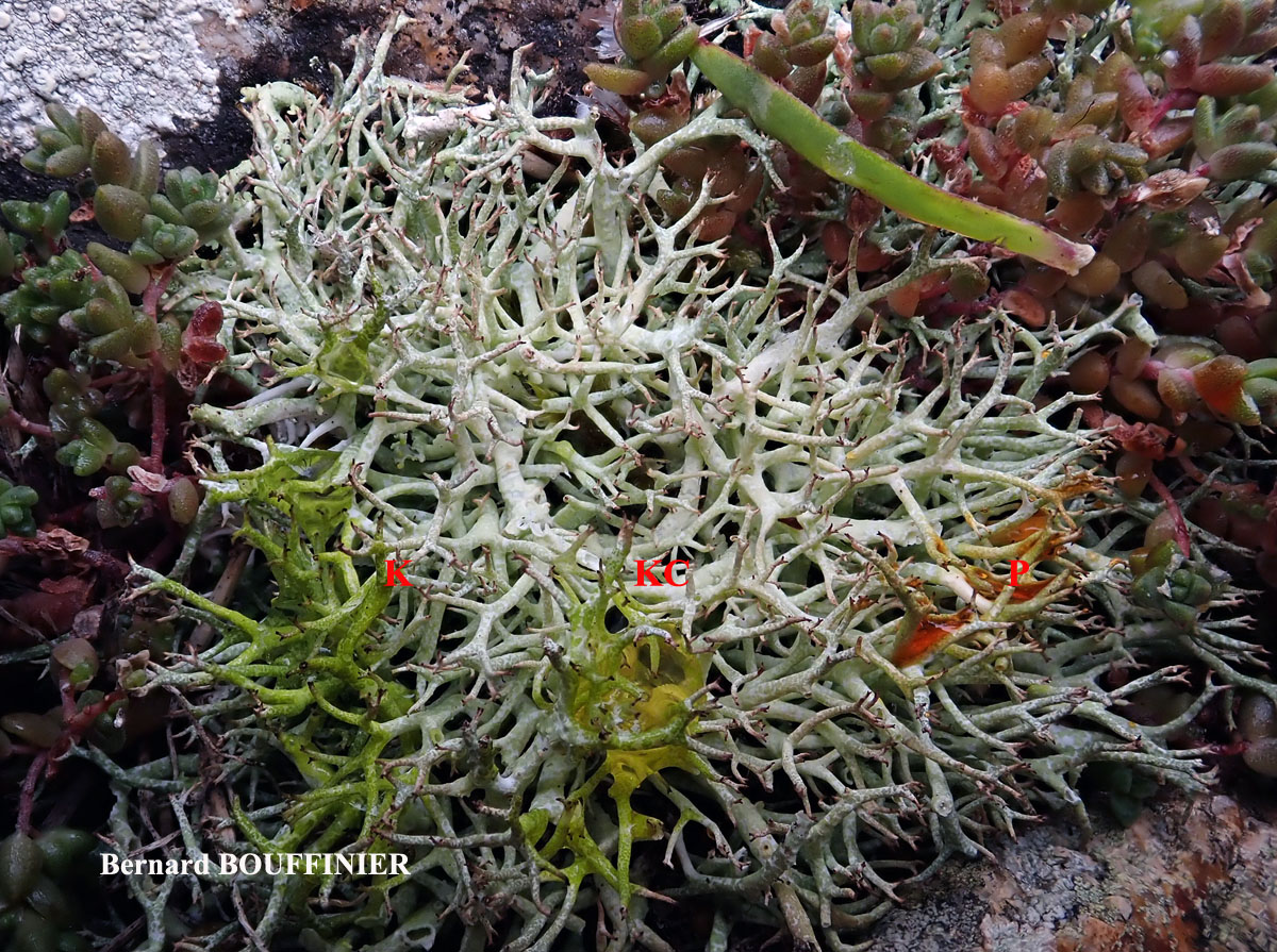
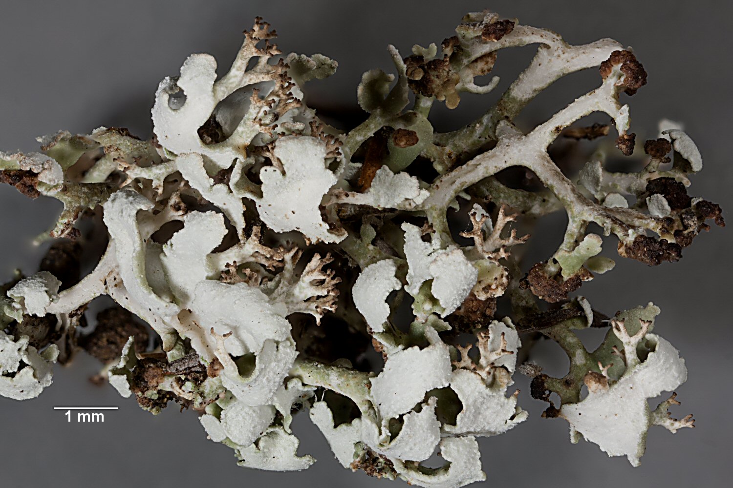
Description: Primary thallus squamulose, persistent in young specimens, then often evanescent, the squamules middle-sized, 2-4 mm long, 1-2 mm wide, ascending or often forming rosettes, grey green above, white beneath. Podetia shrubby, hollow inside, 2-6 cm tall, richly branched, forming dense tufts, greenish grey to whitish grey, with pointed apices (except in fertile specimens) and a corticate, sparsely to densely squamulose surface, without medullary outbursts at the base. Algal layer markedly discontinuous, the algae forming dispersed, raised, green areoles separated by conspicuous white lines. Apothecia rare, terminal, dark brown, convex, sometimes gathered in subcorymbose clusters. Asci 8-spored, clavate, thickened at apex, with a K/I+ blue tholus and a K/I+ strongly blue outer gelatinous sheath, Cladonia-type. Ascospores 1-celled, hyaline, ellipsoid. Pycnidia dark, semi-immersed on the tips of podetia, with a colourless jelly. Conidia hyaline, curved. Photobiont chlorococcoid. Spot tests and chemistry: three chemotypes (all of them C-, KC-, UV-): 1) K+ yellow, P– (atranorin, rangiformic and norrangiformic acids), 2) K+ yellow, P+ red (atranorin, rangiformic, norrangiformic acids and fumarprotocetraric acid complex), 3) K+ yellow, P+ yellow (atranorin, rangiformic and psoromic acids). Chemotype 3) is hitherto known only from Spain and the Balkan Peninsula.
Growth form: Fruticose
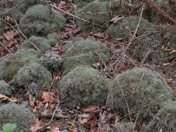
Substrata: soil, terricolous mosses, and plant debris
Photobiont: green algae other than Trentepohlia
Reproductive strategy: mainly sexual
Commonnes-rarity: (info)
Alpine belt: absent
Subalpine belt: extremely rare
Montane belt: common
Dry submediterranean belt: extremely common
Humid submediterranean belt: extremely common
Padanian area: very rare
pH of the substrata:
1 2 3 4 5

Solar irradiation:
1 2 3 4 5
Aridity:
1 2 3 4 5
Eutrophication:
1 2 3 4 5
Poleotolerance:
0 1 2 3
Altitudinal distribution:
1 2 3 4 5 6
Rarity
absent
extremely rare
very rare
rare
rather rare
rather common
common
very common
extremely common
Loading data...
Occurrence data
Predictive map
 Current prediction (1981-2010)
 Future prediction (2071-2100) SSP 1-2.6
 Future prediction (2071-2100) SSP 5-8.5Predictive maps according to Francesconi et al. 2025
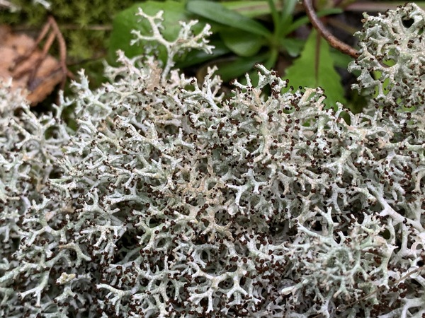
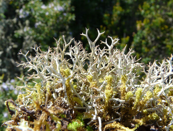
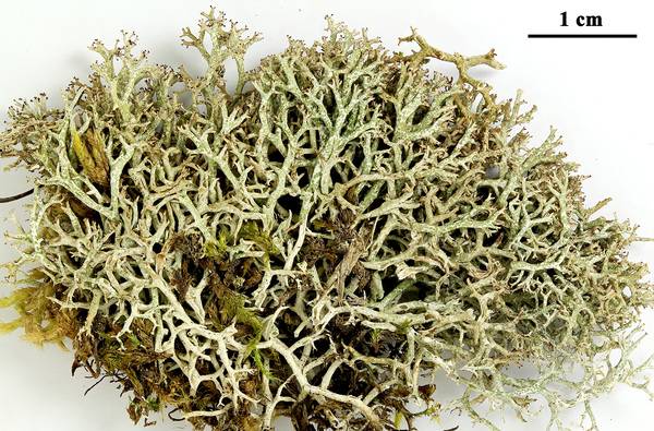
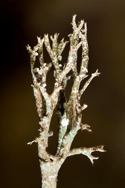
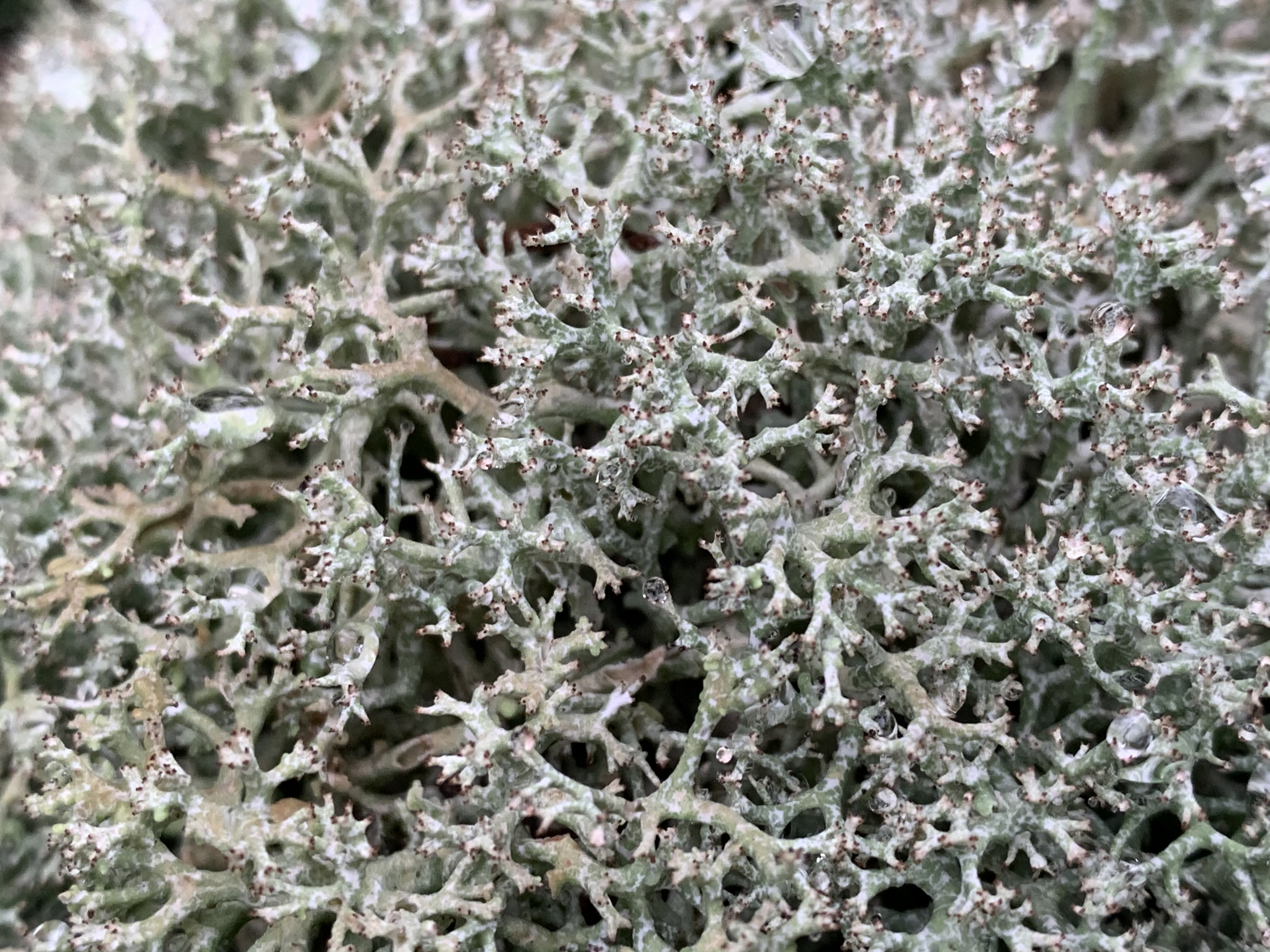
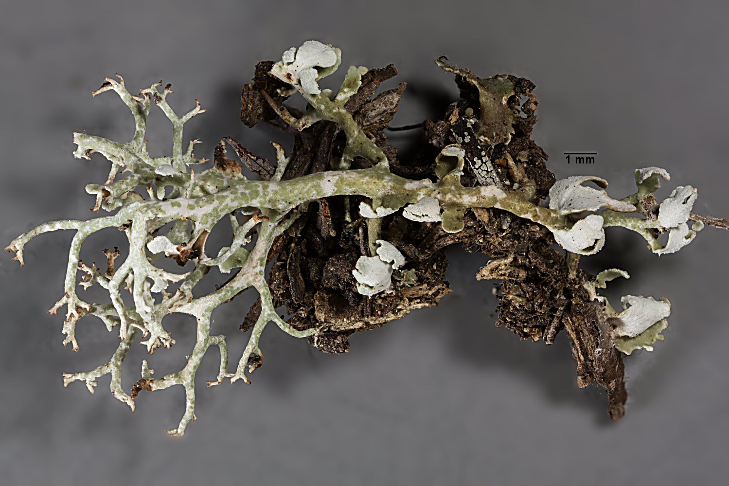
Gabriele Gheza - https://lichenidilombardia.home.blog
Italy, Toscana, Firenze, Fiesole, Monte Ceceri, 390 m
31/01/2020
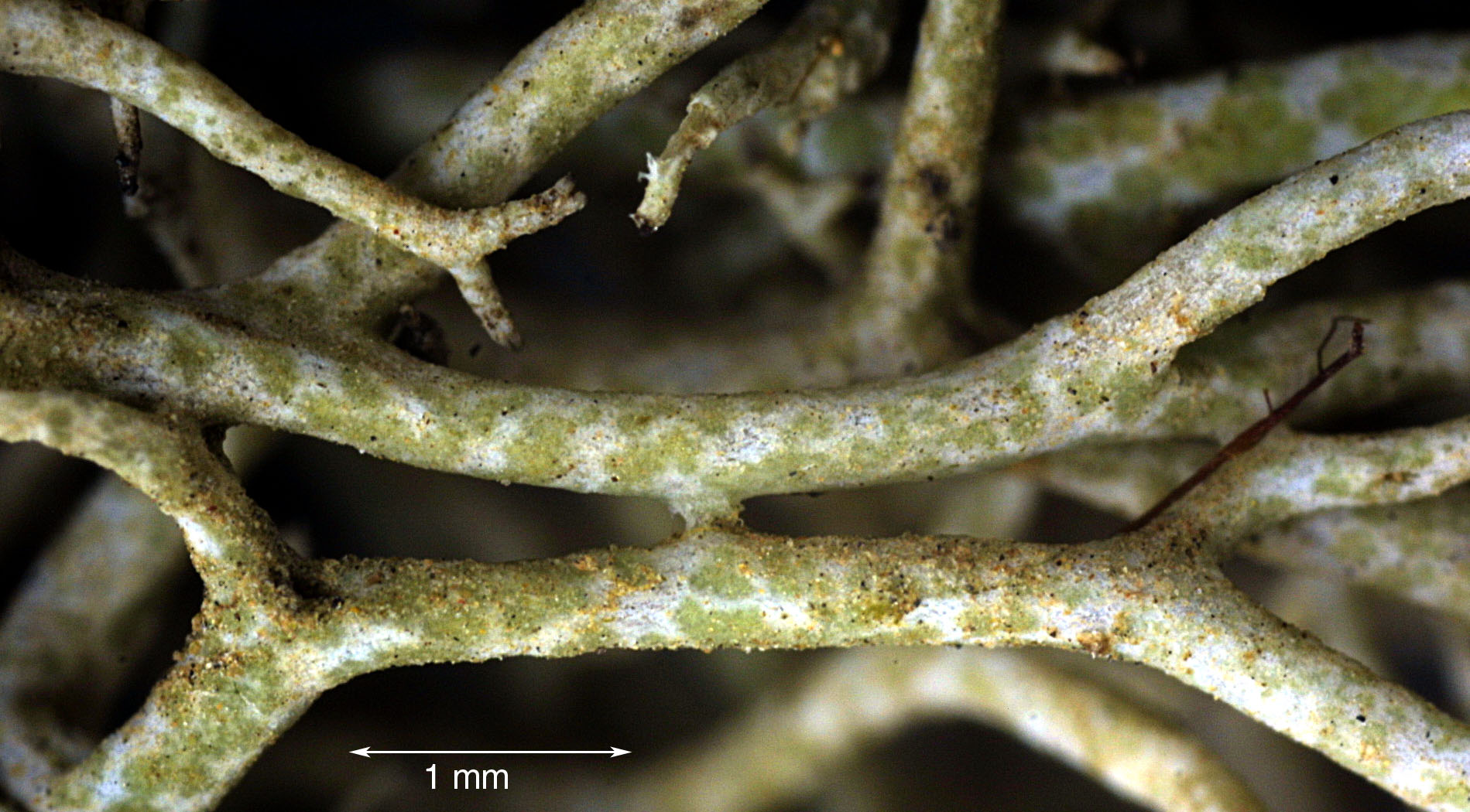
P.L. Nimis; Owner: Department of Life Sciences, University of Trieste
Herbarium: TSB (33876)
2001/12/09
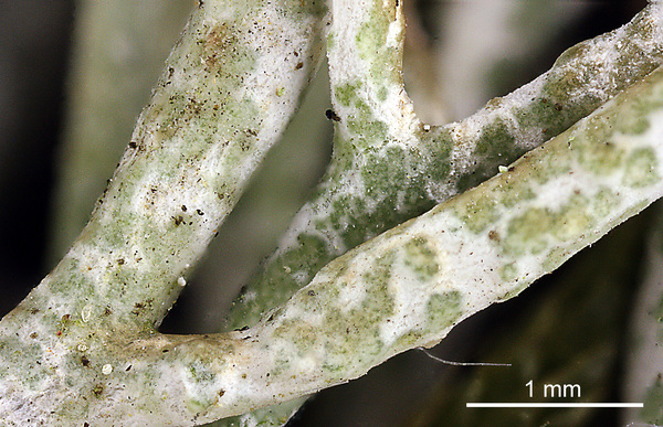
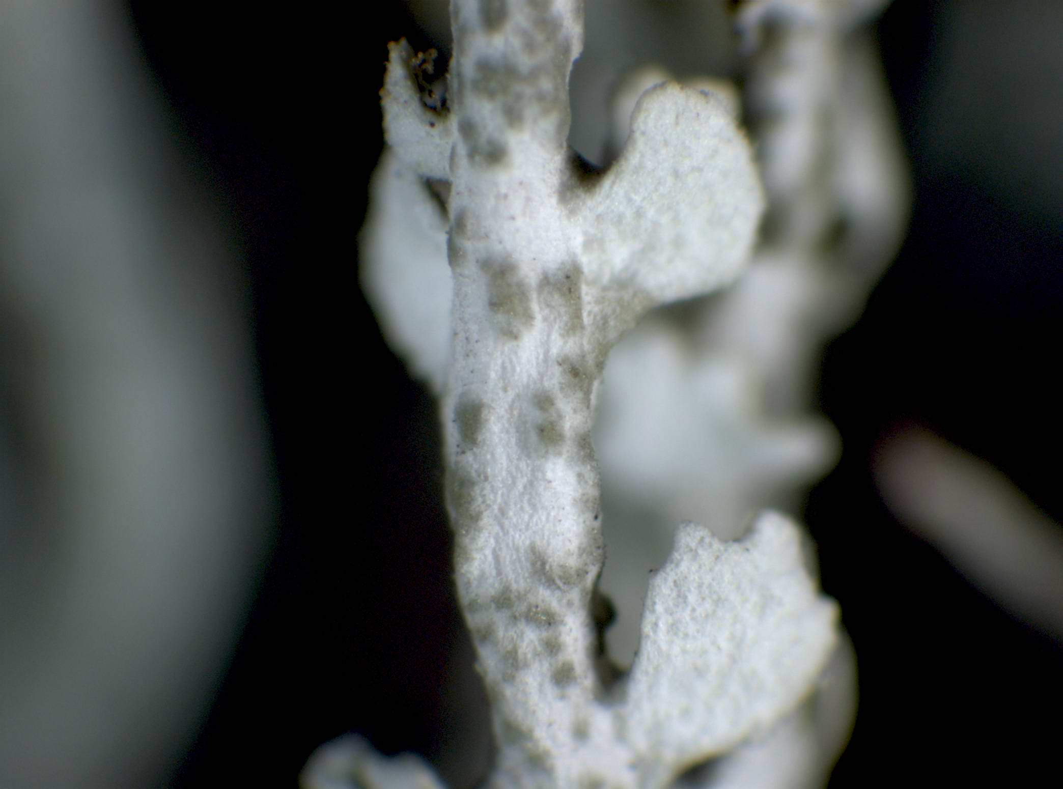
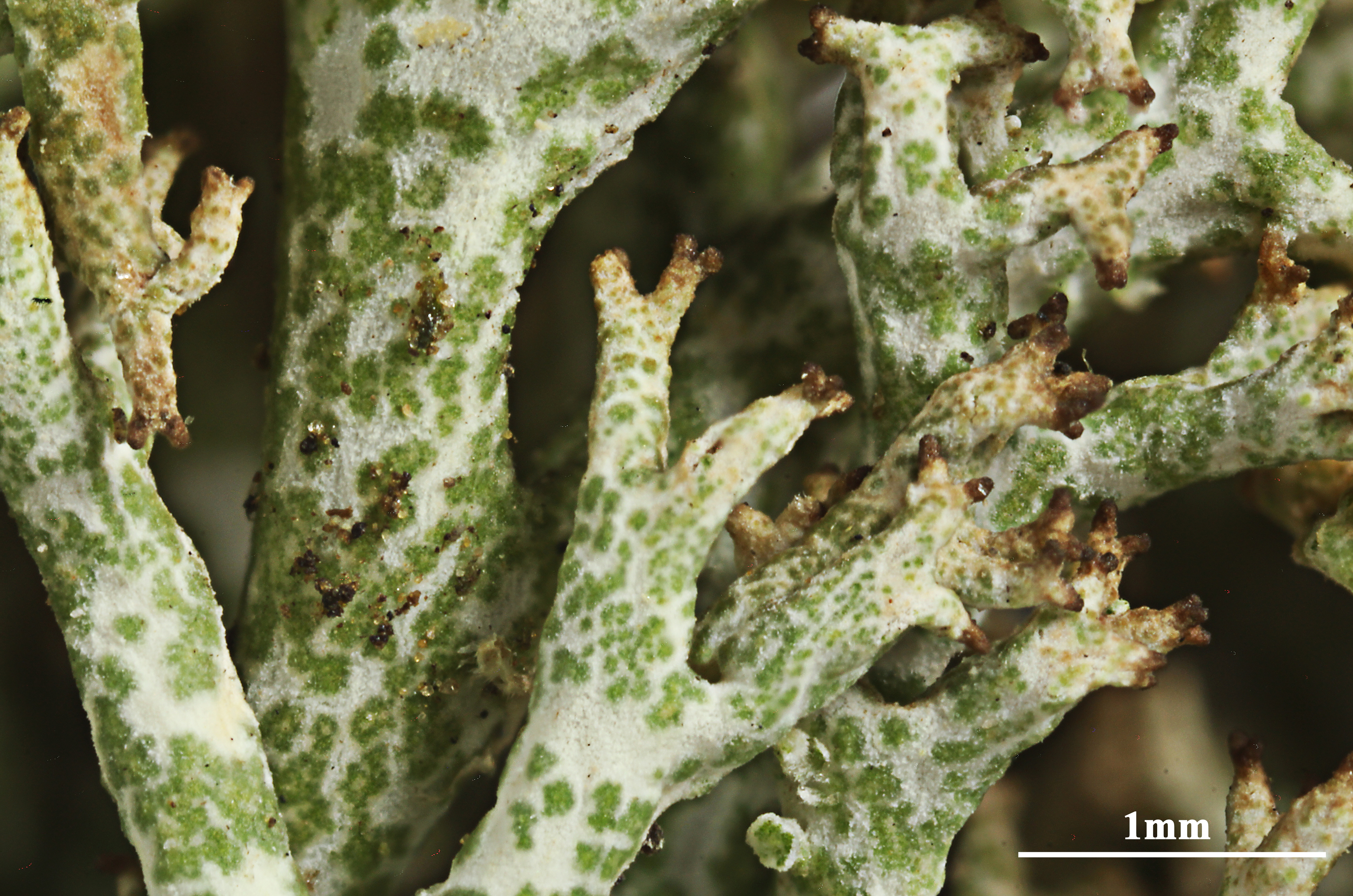
detail of branch with squamules

Simonetta Peruzzi; Owner: Simonetta Peruzzi
Italy, Toscana, Parco Nazionale delle Foreste Casentinesi
2010

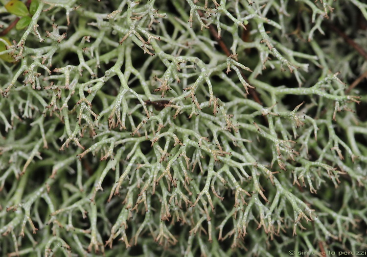
Paolo Fontanesi; Owner: Paolo Fontanesi
Italy, Emilia-Romagna, Reggio Emilia, Riserva Naturale di Campotrera.
Herbarium: Forum Natura Mediterraneo
2010

Andrea Moro; Owner: Department of Life Sciences, University of Trieste
Italy, Friuli Venezia Giulia, Trieste, Trieste Karst. Loc. Slivia,near the Castelliere
11.2016
Felix Schumm – CC BY-SA 4.0
[9232], Spanien, Kanaren, La Gomera: Am Weg zum Garajonay vom Parkplatz Contadero-Mimbreras. Lorbeer-Erica Wald. 28°06.828' N, 17°14.624 W, 1440 m. Auf Erde an Wegböschung. Leg. Schumm 11.02.2002 det. Schumm 2007
Felix Schumm – CC BY-SA 4.0
[9232], Spanien, Kanaren, La Gomera: Am Weg zum Garajonay vom Parkplatz Contadero-Mimbreras. Lorbeer-Erica Wald. 28°06.828' N, 17°14.624 W, 1440 m. Auf Erde an Wegböschung. Leg. Schumm 11.02.2002 det. Schumm 2007
Felix Schumm – CC BY-SA 4.0
[9232], Spanien, Kanaren, La Gomera: Am Weg zum Garajonay vom Parkplatz Contadero-Mimbreras. Lorbeer-Erica Wald. 28°06.828' N, 17°14.624 W, 1440 m. Auf Erde an Wegböschung. Leg. Schumm 11.02.2002 det. Schumm 2007

Felix Schumm – CC BY-SA 4.0
[9232], Spanien, Kanaren, La Gomera: Am Weg zum Garajonay vom Parkplatz Contadero-Mimbreras. Lorbeer-Erica Wald. 28°06.828' N, 17°14.624 W, 1440 m. Auf Erde an Wegböschung. Leg. Schumm 11.02.2002 det. Schumm 2007
Felix Schumm – CC BY-SA 4.0
[9232], Spanien, Kanaren, La Gomera: Am Weg zum Garajonay vom Parkplatz Contadero-Mimbreras. Lorbeer-Erica Wald. 28°06.828' N, 17°14.624 W, 1440 m. Auf Erde an Wegböschung. Leg. Schumm 11.02.2002 det. Schumm 2007
Felix Schumm – CC BY-SA 4.0
[9232], Spanien, Kanaren, La Gomera: Am Weg zum Garajonay vom Parkplatz Contadero-Mimbreras. Lorbeer-Erica Wald. 28°06.828' N, 17°14.624 W, 1440 m. Auf Erde an Wegböschung. Leg. Schumm 11.02.2002 det. Schumm 2007
Felix Schumm – CC BY-SA 4.0
[9232], Spanien, Kanaren, La Gomera: Am Weg zum Garajonay vom Parkplatz Contadero-Mimbreras. Lorbeer-Erica Wald. 28°06.828' N, 17°14.624 W, 1440 m. Auf Erde an Wegböschung. Leg. Schumm 11.02.2002 det. Schumm 2007
Felix Schumm – CC BY-SA 4.0
[9232], Spanien, Kanaren, La Gomera: Am Weg zum Garajonay vom Parkplatz Contadero-Mimbreras. Lorbeer-Erica Wald. 28°06.828' N, 17°14.624 W, 1440 m. Auf Erde an Wegböschung. Leg. Schumm 11.02.2002 det. Schumm 2007
Felix Schumm – CC BY-SA 4.0
[16609], Germany, Baden-Württemberg, Alb-Donau-Kreis, zwischen Altheim und Gerstetten in Trockenrasen zwischen südexponierten Kalkfelsen im Hungerbrunnental, 48,59616° N, 10,03926° E, 545 m. Leg. et det. Schumm 25.08.2010.
Felix Schumm – CC BY-SA 4.0
[16609], Germany, Baden-Württemberg, Alb-Donau-Kreis, zwischen Altheim und Gerstetten in Trockenrasen zwischen südexponierten Kalkfelsen im Hungerbrunnental, 48,59616° N, 10,03926° E, 545 m. Leg. et det. Schumm 25.08.2010.
Felix Schumm – CC BY-SA 4.0
[16609], Germany, Baden-Württemberg, Alb-Donau-Kreis, zwischen Altheim und Gerstetten in Trockenrasen zwischen südexponierten Kalkfelsen im Hungerbrunnental, 48,59616° N, 10,03926° E, 545 m. Leg. et det. Schumm 25.08.2010.
Felix Schumm – CC BY-SA 4.0
[16609], Germany, Baden-Württemberg, Alb-Donau-Kreis, zwischen Altheim und Gerstetten in Trockenrasen zwischen südexponierten Kalkfelsen im Hungerbrunnental, 48,59616° N, 10,03926° E, 545 m. Leg. et det. Schumm 25.08.2010.
Felix Schumm – CC BY-SA 4.0
[16609], Germany, Baden-Württemberg, Alb-Donau-Kreis, zwischen Altheim und Gerstetten in Trockenrasen zwischen südexponierten Kalkfelsen im Hungerbrunnental, 48,59616° N, 10,03926° E, 545 m. Leg. et det. Schumm 25.08.2010.

Felix Schumm – CC BY-SA 4.0
[16609], Germany, Baden-Württemberg, Alb-Donau-Kreis, zwischen Altheim und Gerstetten in Trockenrasen zwischen südexponierten Kalkfelsen im Hungerbrunnental, 48,59616° N, 10,03926° E, 545 m. Leg. et det. Schumm 25.08.2010.

Felix Schumm – CC BY-SA 4.0
[16609], Germany, Baden-Württemberg, Alb-Donau-Kreis, zwischen Altheim und Gerstetten in Trockenrasen zwischen südexponierten Kalkfelsen im Hungerbrunnental, 48,59616° N, 10,03926° E, 545 m. Leg. et det. Schumm 25.08.2010.
Felix Schumm – CC BY-SA 4.0
[16609], Germany, Baden-Württemberg, Alb-Donau-Kreis, zwischen Altheim und Gerstetten in Trockenrasen zwischen südexponierten Kalkfelsen im Hungerbrunnental, 48,59616° N, 10,03926° E, 545 m. Leg. et det. Schumm 25.08.2010.
Felix Schumm – CC BY-SA 4.0
[16609], Germany, Baden-Württemberg, Alb-Donau-Kreis, zwischen Altheim und Gerstetten in Trockenrasen zwischen südexponierten Kalkfelsen im Hungerbrunnental, 48,59616° N, 10,03926° E, 545 m. Leg. et det. Schumm 25.08.2010.
Felix Schumm – CC BY-SA 4.0
[16609], Germany, Baden-Württemberg, Alb-Donau-Kreis, zwischen Altheim und Gerstetten in Trockenrasen zwischen südexponierten Kalkfelsen im Hungerbrunnental, 48,59616° N, 10,03926° E, 545 m. Leg. et det. Schumm 25.08.2010.
Felix Schumm – CC BY-SA 4.0
Image from: F. Schumm (2008) - Flechten Madeiras, der Kanaren und Azoren. Beck, OHG - ISBN: 978-3-00-023700-3
Felix Schumm – CC BY-SA 4.0
[19464], Germany, Hessen, Amöneburg bei Marburg, sonnige Basaltblöcke in einer Hangwiese kurz vor dem Ortseingang, 50.7896° N, 8.91995° E, 324 m. Leg. F. Schumm, 01.08.2016, det. F. Schumm.
A. Moro; Owner: Department of Life Sciences, University of Trieste
Sicilia, TP, Isola di Marettimo
2008.04.03
Felix Schumm – CC BY-SA 4.0
[12436], Griechenland, N-Samos, südlich von Agios Konstandinos, an der Straße nach Manolates, sonnige Terrassenmauern, 37°342'N, 26°49.527'E, 318 m. Leg. Schumm, Düll, Maier 05.05.2006.
Felix Schumm – CC BY-SA 4.0
[12436], Griechenland, N-Samos, südlich von Agios Konstandinos, an der Straße nach Manolates, sonnige Terrassenmauern, 37°342'N, 26°49.527'E, 318 m. Leg. Schumm, Düll, Maier 05.05.2006.
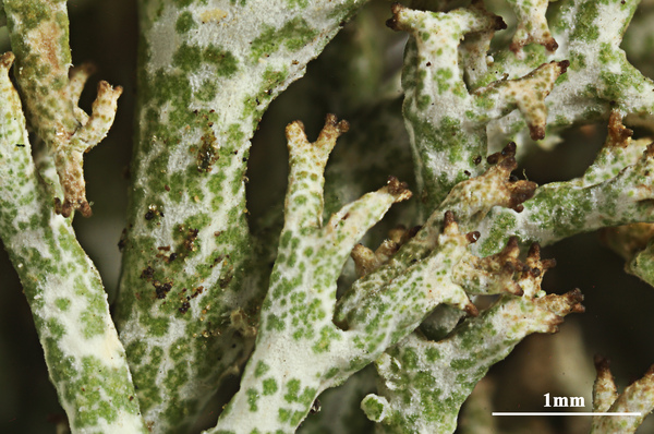
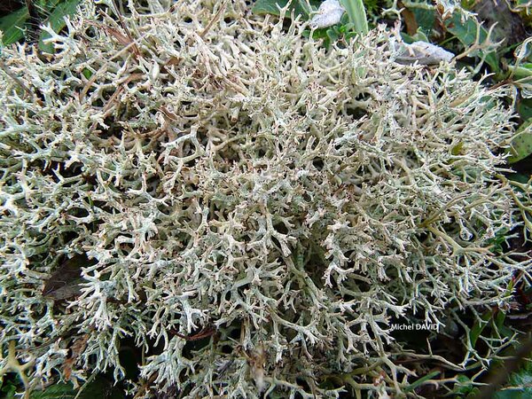
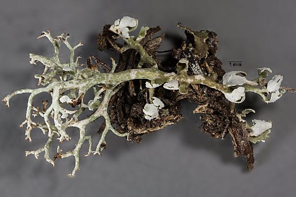
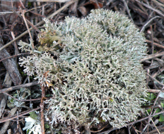
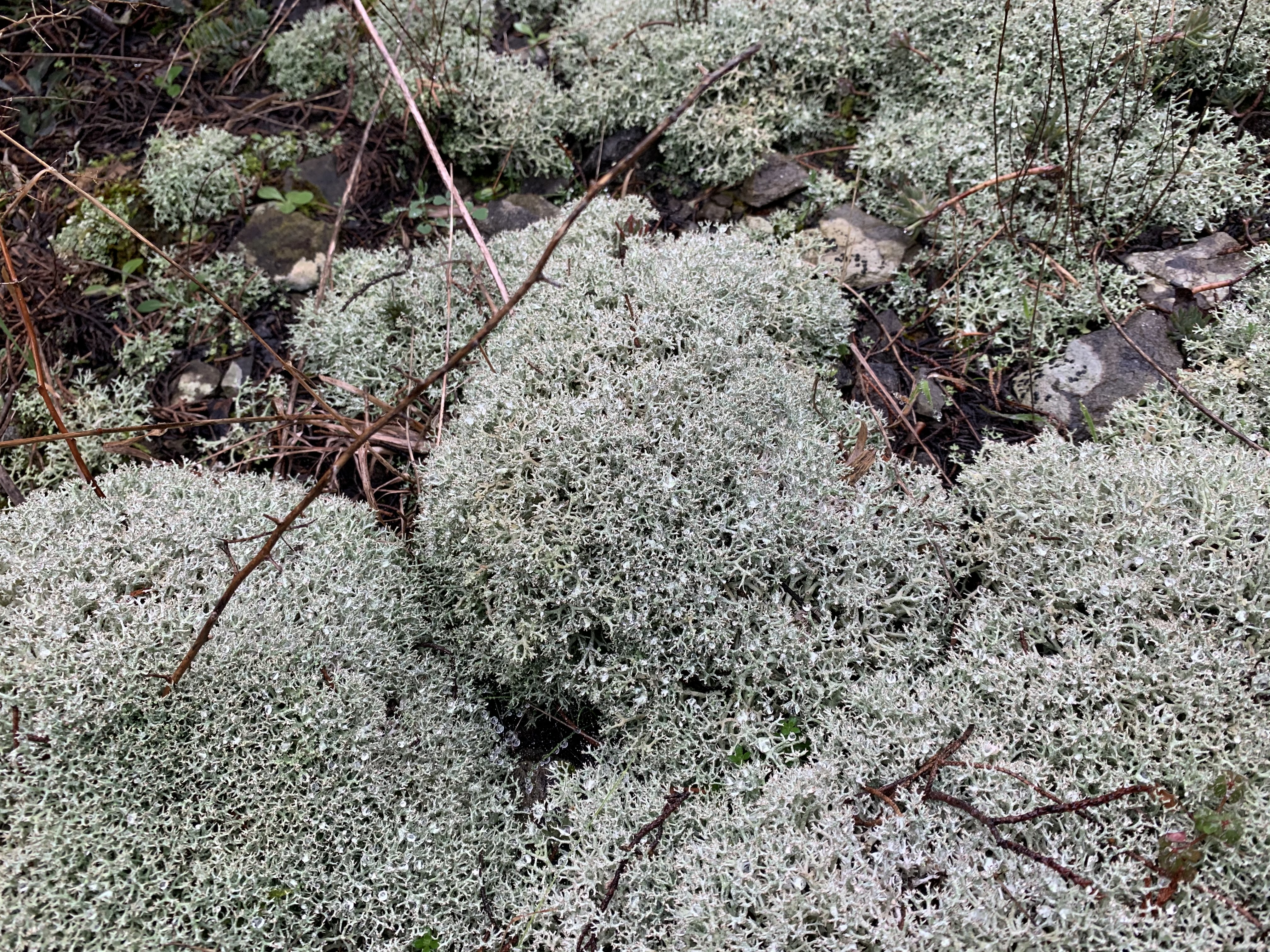
Gabriele Gheza - https://lichenidilombardia.home.blog
Italy, Piemonte, Novara, Trecate, valle del Ticino, 120 m
09/03/2021
primary thallus
Gabriele Gheza - https://lichenidilombardia.home.blog
Italy, Lombardia, Milano, Motta Visconti, valle del Ticino, 76 m
29/01/2021

Gabriele Gheza - https://lichenidilombardia.home.blog
Italy, Lombardia, Milano, Motta Visconti, valle del Ticino, 76 m
29/01/2021

Gabriele Gheza - https://lichenidilombardia.home.blog
Italy, Toscana, Firenze, Fiesole, Monte Ceceri, 390 m
31/01/2020
Felix Schumm – CC BY-SA 4.0
[19464], Germany, Hessen, Amöneburg bei Marburg, sonnige Basaltblöcke in einer Hangwiese kurz vor dem Ortseingang, 50.7896° N, 8.91995° E, 324 m. Leg. F. Schumm, 01.08.2016, det. F. Schumm.
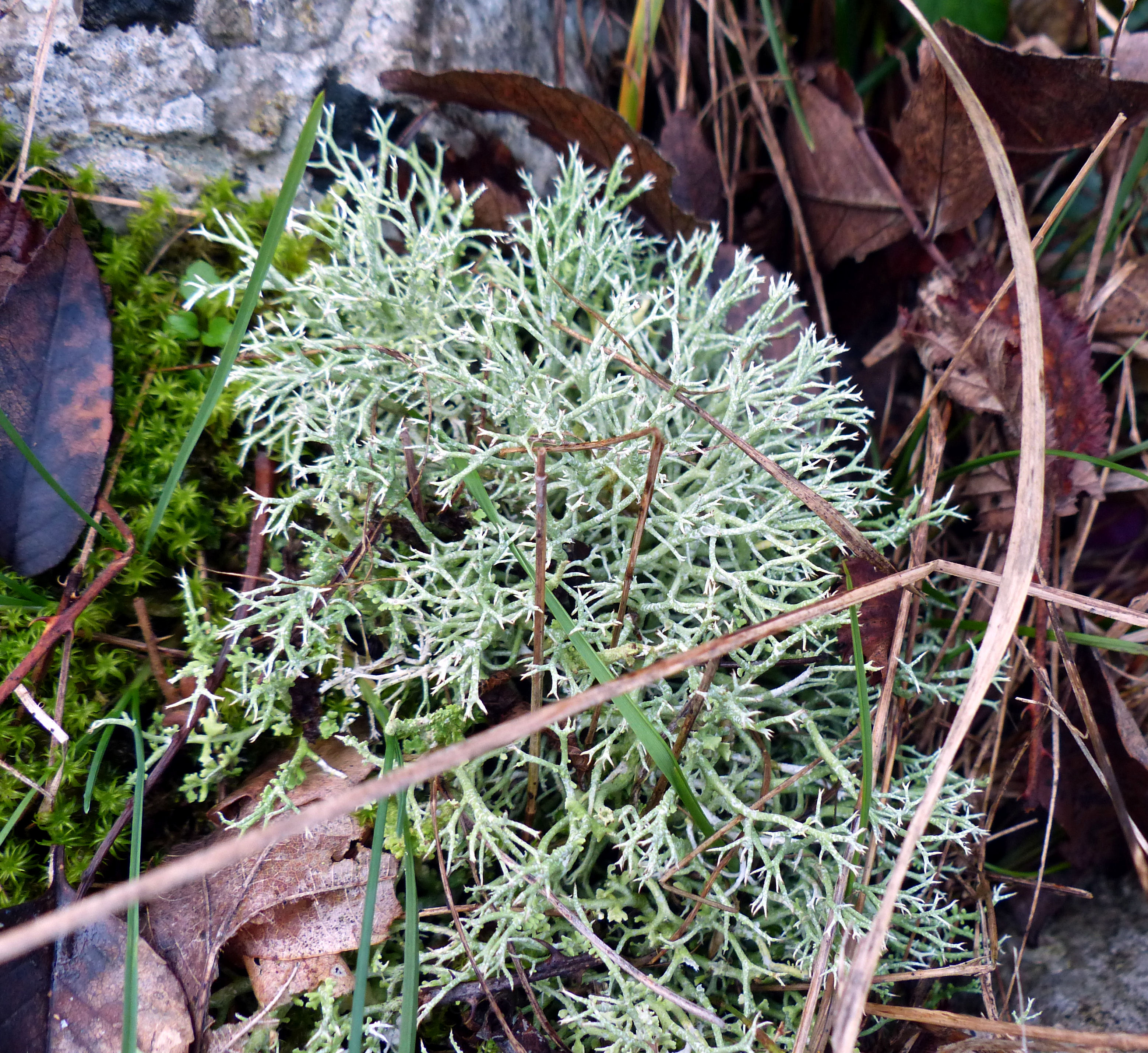
Gabriele Gheza - https://lichenidilombardia.home.blog
Italy, Toscana, Firenze, Fiesole, Monte Ceceri, 390 m
31/01/2020
Gabriele Gheza - https://lichenidilombardia.home.blog
Italy, Toscana, Firenze, Fiesole, Monte Ceceri, 390 m
31/01/2020

Gabriele Gheza - https://lichenidilombardia.home.blog
Italy, Toscana, Firenze, Fiesole, Monte Ceceri, 390 m
31/01/2020
Gabriele Gheza - https://lichenidilombardia.home.blog
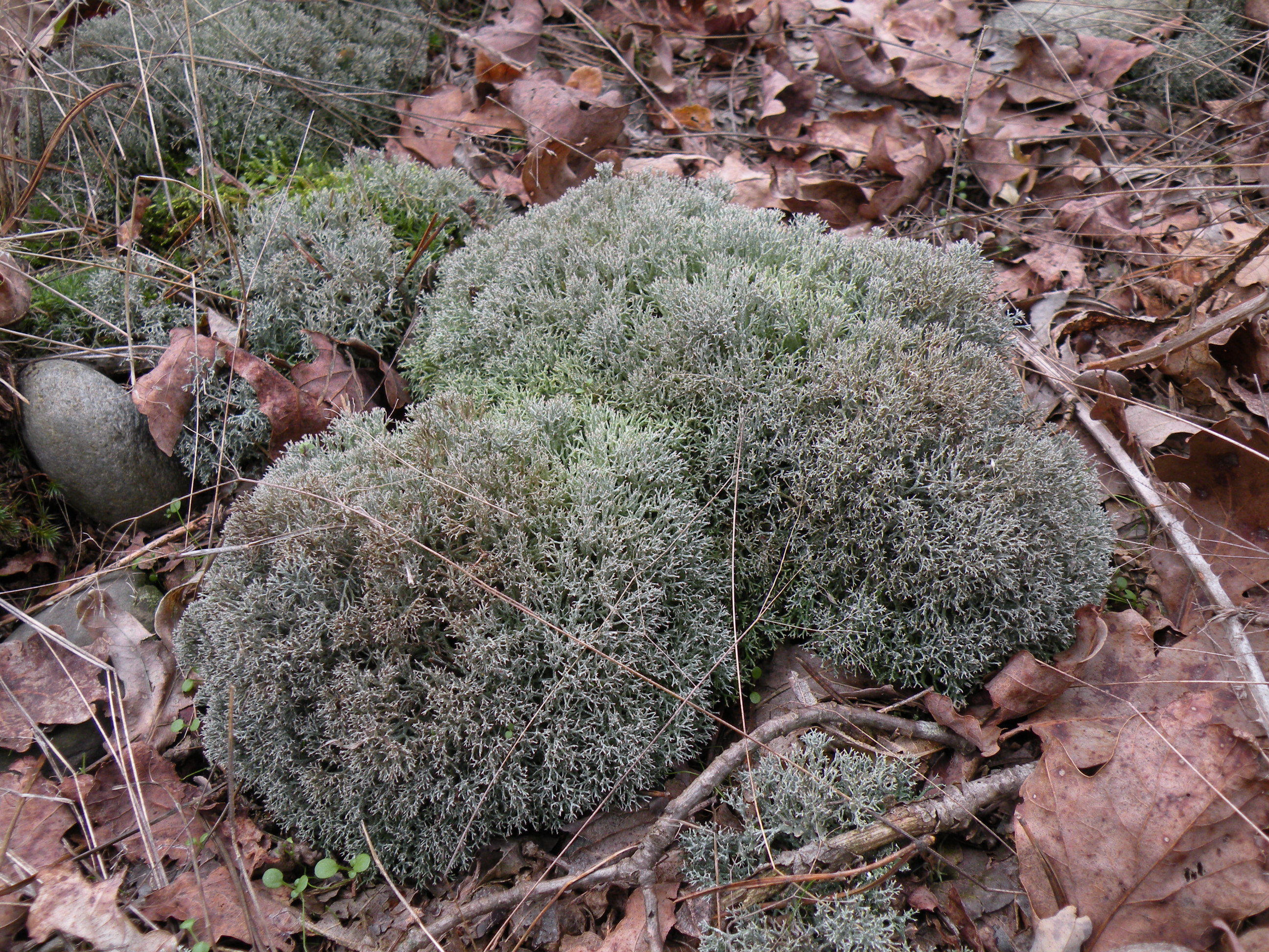
Italy, Piemonte, Novara, Oleggio, valle del Ticino, 163 m
10/2013

Gabriele Gheza - https://lichenidilombardia.home.blog
Italy, Piemonte, Novara, Oleggio, valle del Ticino, 163 m
10/2013

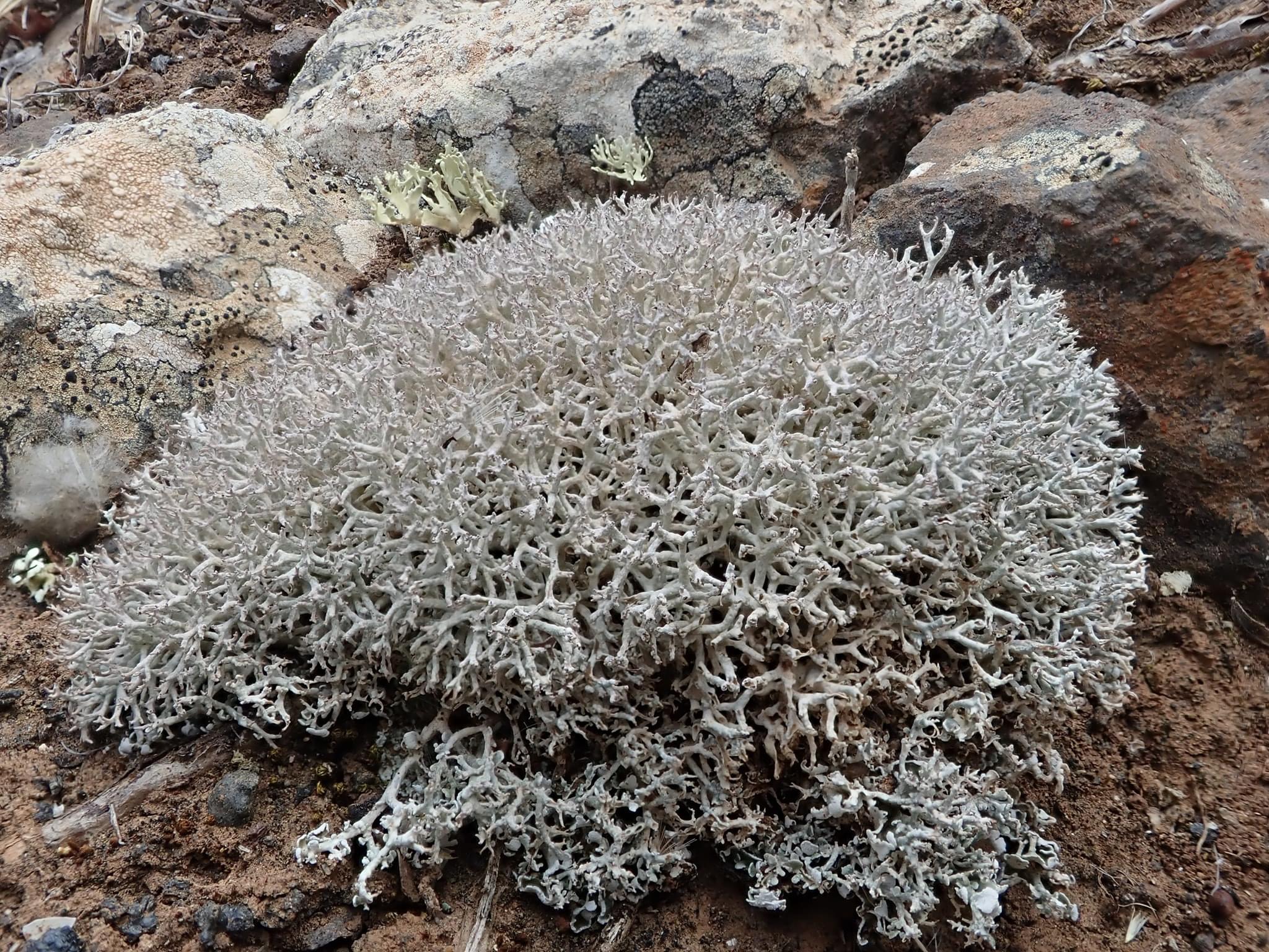
Manuel Gil
Spain, Canary Islands, Lanzarote
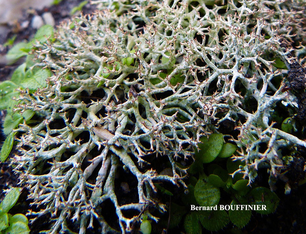
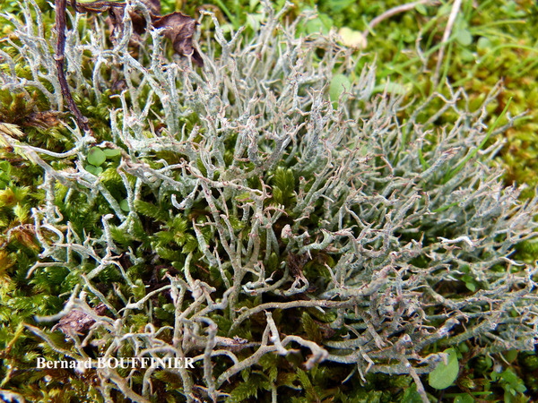
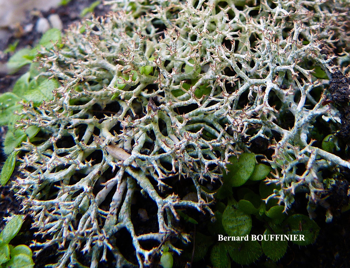
Bernard Bouffinier - Source: http://www.lichensmaritimes.org/index.php?task=fiche&lichen=227&lang=en
France, Crozon
Bernard Bouffinier - Source: http://www.lichensmaritimes.org/index.php?task=fiche&lichen=227&lang=en
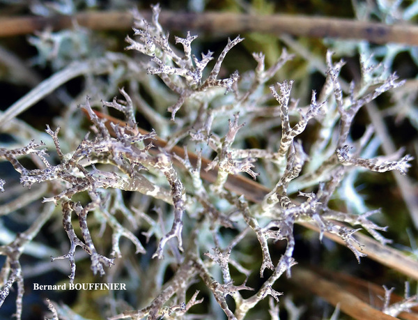
France, Ty Lann
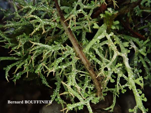
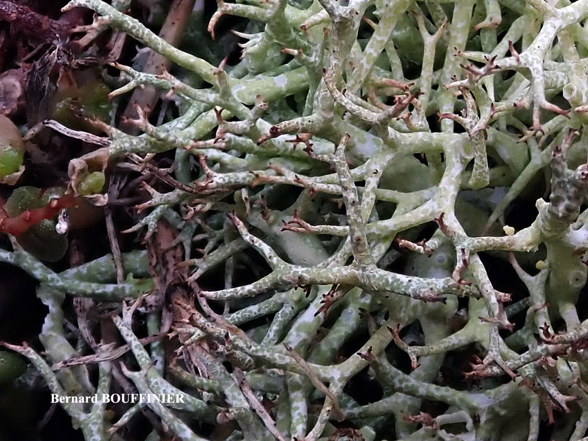
Bernard Bouffinier - Source: http://www.lichensmaritimes.org/index.php?task=fiche&lichen=227&lang=en
France, Ty Lann
Bernard Bouffinier - Source: http://www.lichensmaritimes.org/index.php?task=fiche&lichen=227&lang=en
France, Ty Lann
Bernard Bouffinier - Source: http://www.lichensmaritimes.org/index.php?task=fiche&lichen=227&lang=en
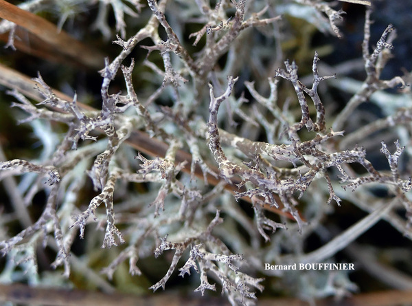
France, Primel
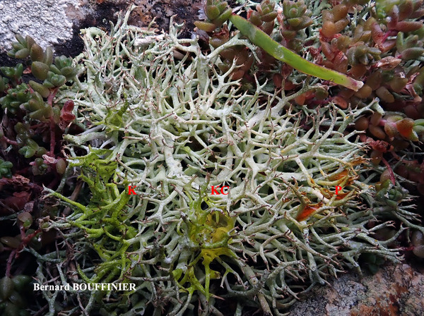
P+ rouge

Bernard Bouffinier - Source: http://www.lichensmaritimes.org/index.php?task=fiche&lichen=227&lang=en
France, Primel
P+ rouge
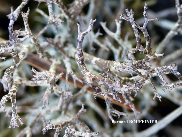
Bernard Bouffinier - Source: http://www.lichensmaritimes.org/index.php?task=fiche&lichen=227&lang=en
France, Primel
P+ rouge
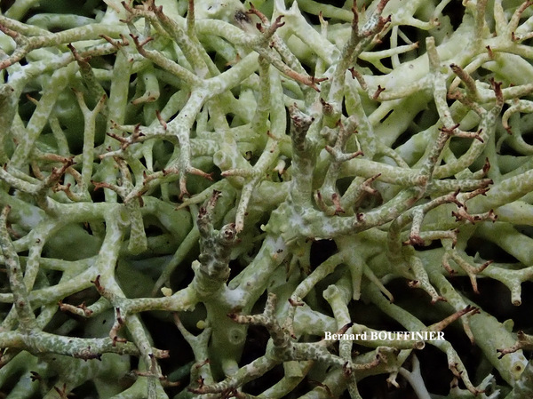
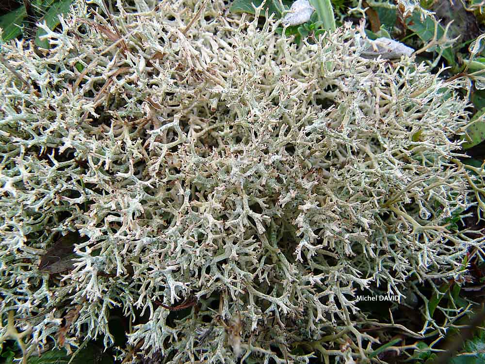
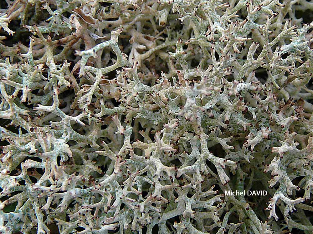
Michel David - Source: http://www.lichensmaritimes.org/index.php?task=fiche&lichen=227&lang=en
France, La Palue

Michel David - Source: http://www.lichensmaritimes.org/index.php?task=fiche&lichen=227&lang=en
France, La Palue

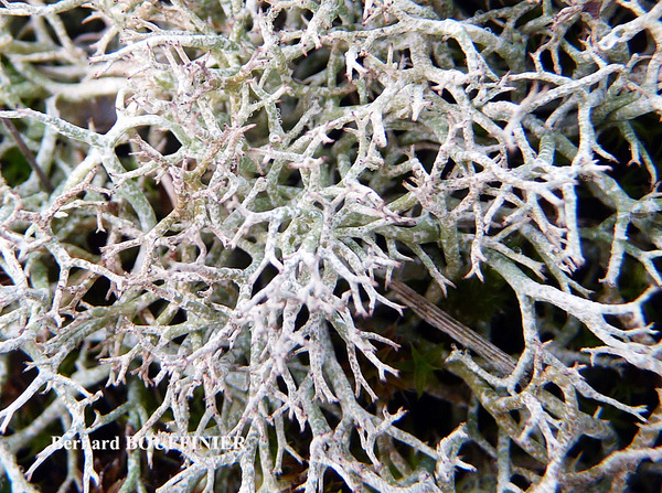
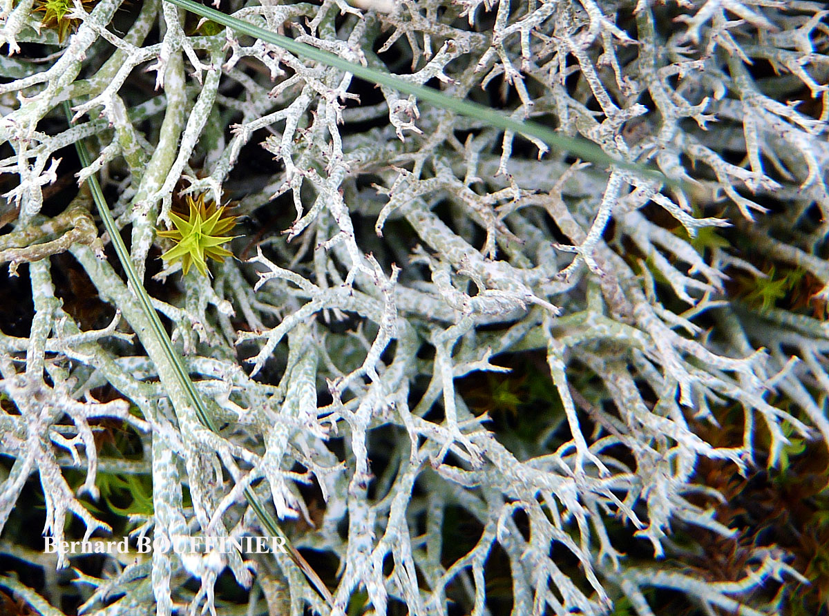
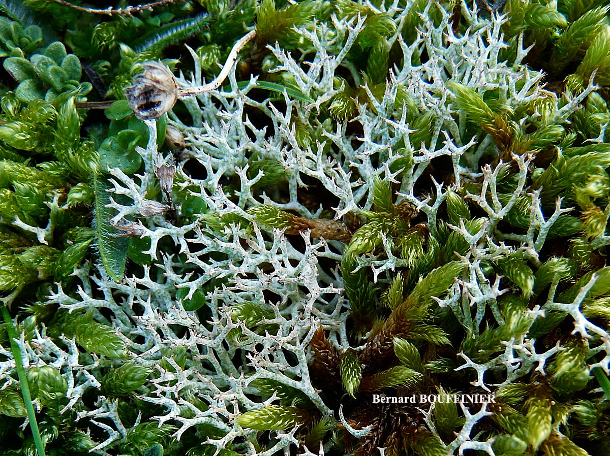
Bernard Bouffinier - Source: http://www.lichensmaritimes.org/index.php?task=fiche&lichen=1335&lang=en
France, Sainte Anne la Palud
var. pungens
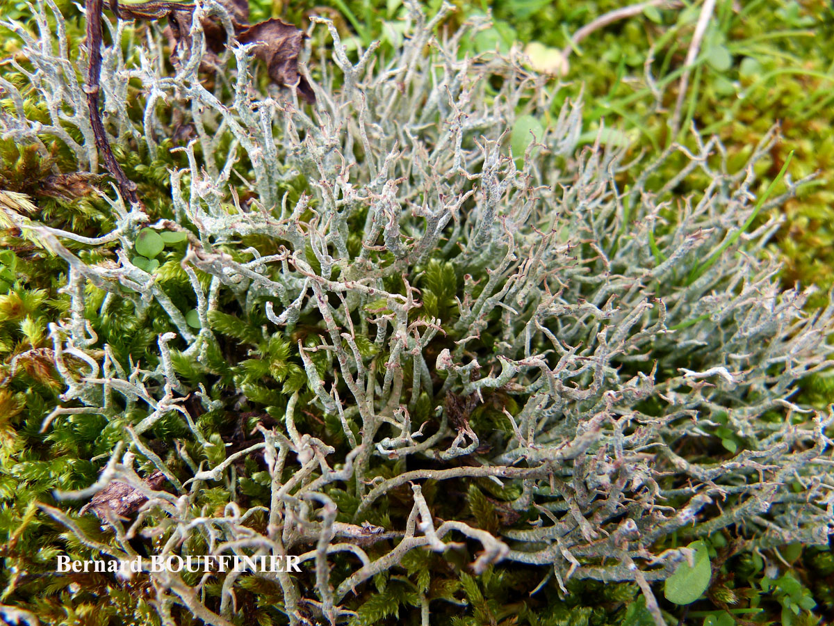
Bernard Bouffinier - Source: http://www.lichensmaritimes.org/index.php?task=fiche&lichen=1335&lang=en
France, Sainte Anne la Palud
var. pungens
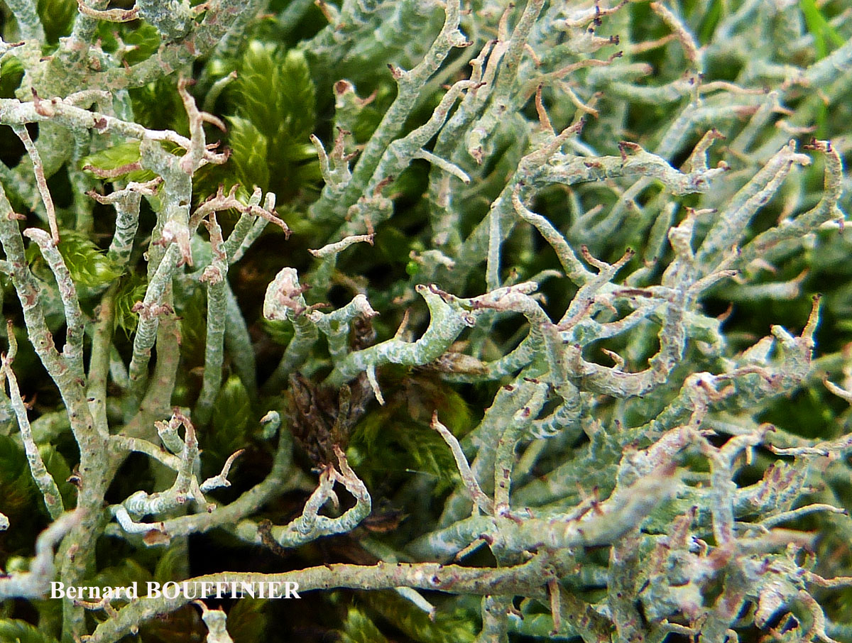
Bernard Bouffinier - Source: http://www.lichensmaritimes.org/index.php?task=fiche&lichen=1335&lang=en
France, Sainte Anne la Palud
var. pungens

Bernard Bouffinier - Source: http://www.lichensmaritimes.org/index.php?task=fiche&lichen=1335&lang=en
France, Sainte Anne la Palud
var. pungens

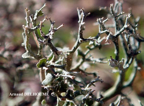
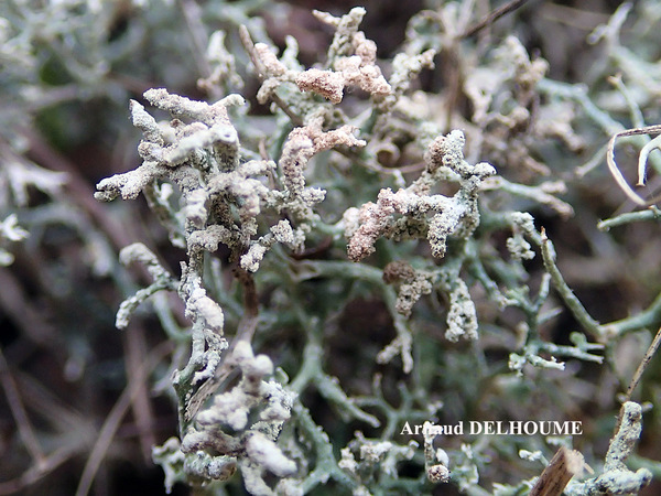
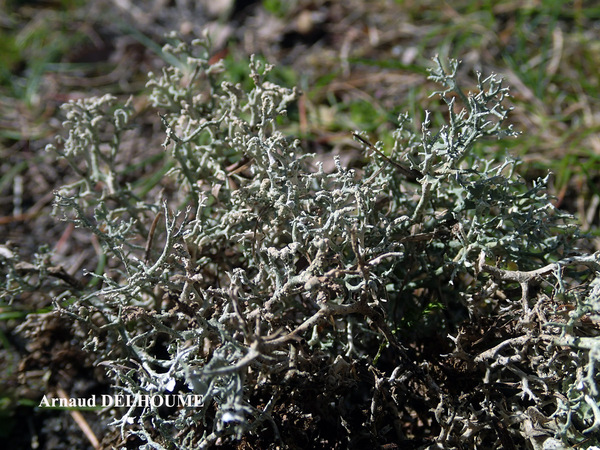
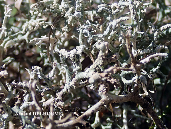
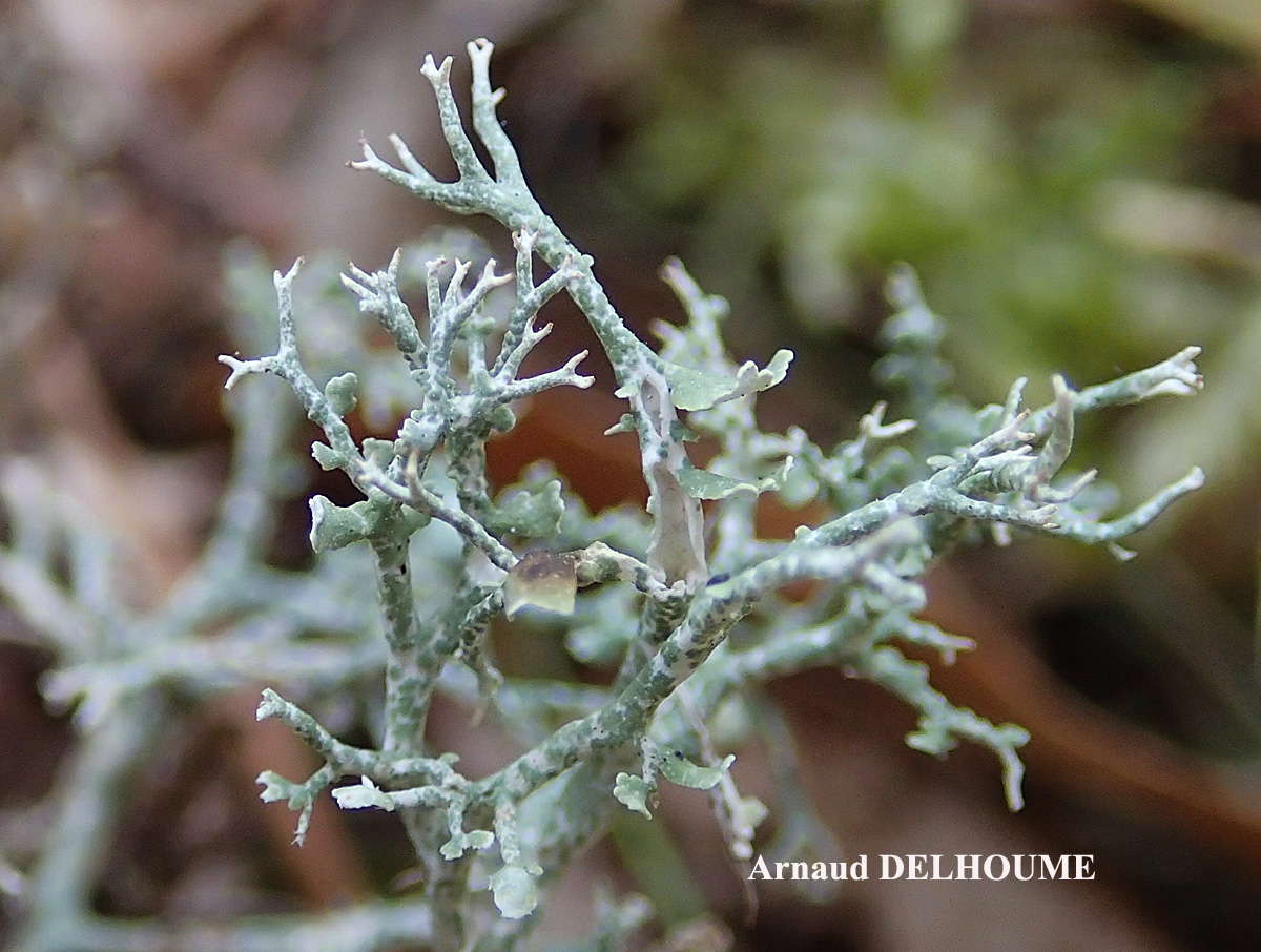
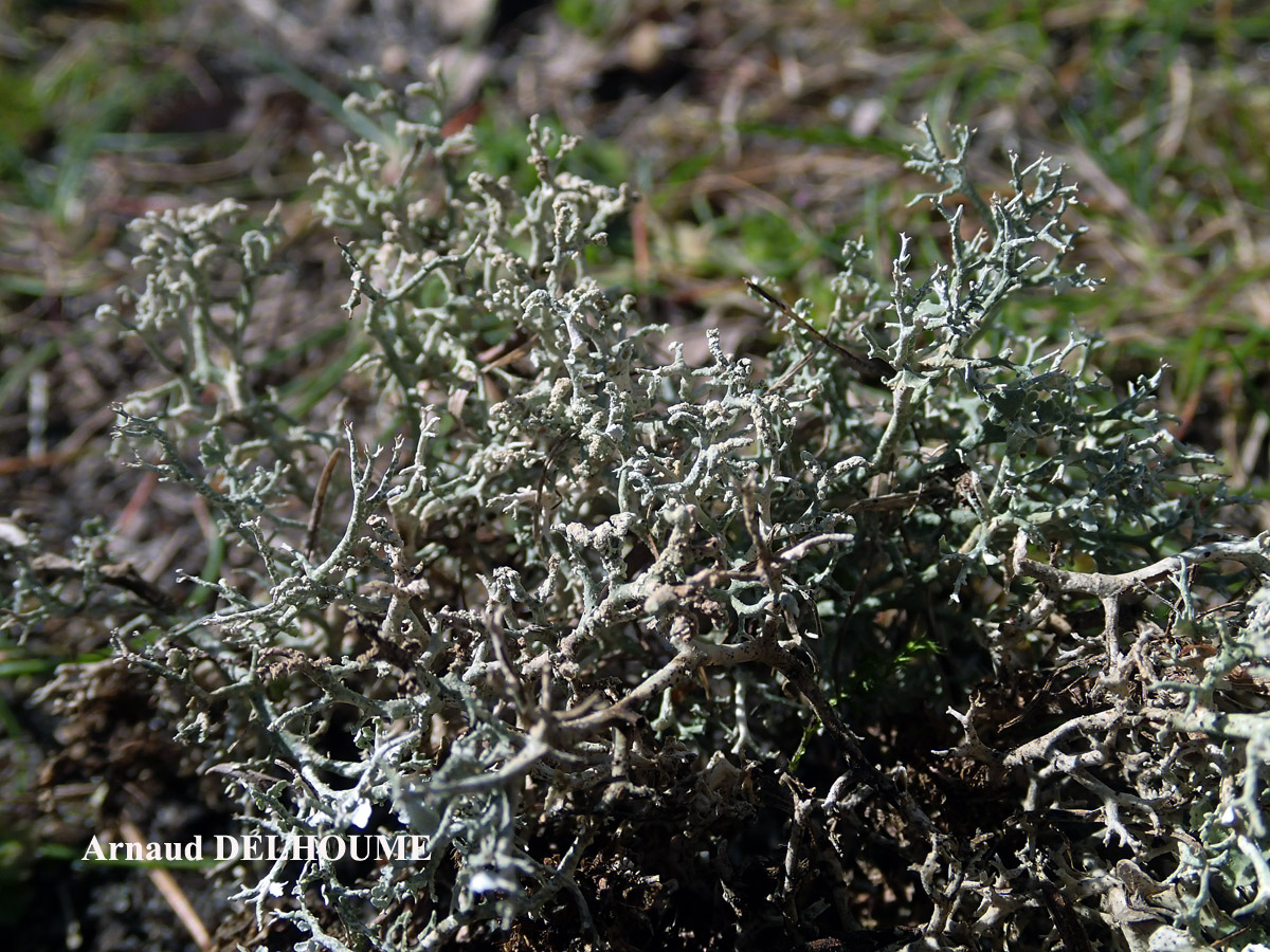
Arnaud Delhoume - Source: http://www.lichensmaritimes.org/index.php?task=fiche&lichen=1335&lang=en
Croatia
var. pungens
Arnaud Delhoume - Source: http://www.lichensmaritimes.org/index.php?task=fiche&lichen=1335&lang=en
Croatia
var. pungens

Bernard Bouffinier - Source: http://www.lichensmaritimes.org/index.php?task=fiche&lichen=1335&lang=en
France, La Palue
var. pungens
Bernard Bouffinier - Source: http://www.lichensmaritimes.org/index.php?task=fiche&lichen=1335&lang=en
France, Manosque
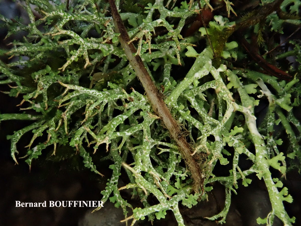
var. pungens
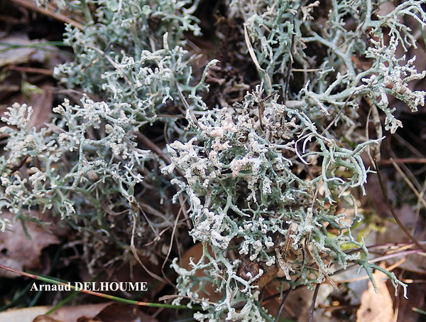
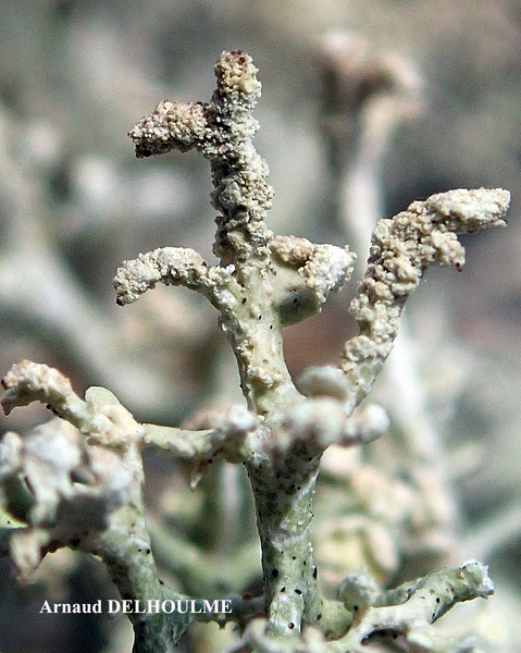
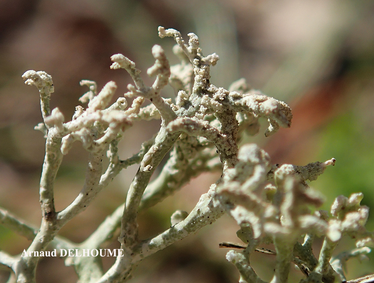
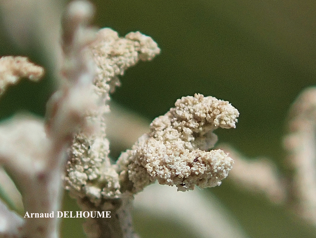
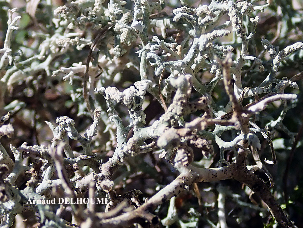
Arnaud Delhoume - Source: http://www.lichensmaritimes.org/index.php?task=fiche&lichen=1335&lang=en
Croatia
var. pungens, sorediate form
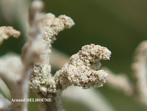
Arnaud Delhoume - Source: http://www.lichensmaritimes.org/index.php?task=fiche&lichen=1335&lang=en
Croatia
var. pungens, sorediate form
Arnaud Delhoume - Source: http://www.lichensmaritimes.org/index.php?task=fiche&lichen=1335&lang=en
Croatia
var. pungens, sorediate form

Arnaud Delhoume - Source: http://www.lichensmaritimes.org/index.php?task=fiche&lichen=1335&lang=en
Croatia
var. pungens, sorediate form
Arnaud Delhoume - Source: http://www.lichensmaritimes.org/index.php?task=fiche&lichen=1335&lang=en
Croatia
var. pungens, sorediate form
Arnaud Delhoume - Source: http://www.lichensmaritimes.org/index.php?task=fiche&lichen=1335&lang=en
Croatia
var. pungens, sorediate form
Arnaud Delhoume - Source: http://www.lichensmaritimes.org/index.php?task=fiche&lichen=1335&lang=en
Croatia
var. pungens, sorediate form
Ulrich Kirschbaum CC BY-SA 4.0 - Source: https://www.thm.de/lse/ulrich-kirschbaum/flechtenbilder
Canary Islands; La Gomera-MN; s of Las Rosas; s of Roque Blanco: near Mirador Dinero.
Ulrich Kirschbaum CC BY-SA 4.0 - Source: https://www.thm.de/lse/ulrich-kirschbaum/flechtenbilder
Canary Islands; La Gomera-MN; s of Las Rosas; s of Roque Blanco: near Mirador Dinero.
Ulrich Kirschbaum CC BY-SA 4.0 - Source: https://www.thm.de/lse/ulrich-kirschbaum/flechtenbilder
Central Europe; Germany: Hesse.
with C. rangiferina (left)
Ulrich Kirschbaum CC BY-SA 4.0 - Source: https://www.thm.de/lse/ulrich-kirschbaum/flechtenbilder
Central Europe; Germany: Hesse.
with C. rangiferina (left)
Ulrich Kirschbaum CC BY-SA 4.0 - Source: https://www.thm.de/lse/ulrich-kirschbaum/flechtenbilder
SE Europe; N-Cyprus; E of Girne; Beşparmak Mountains; between Kantara Village and Kantara Castle
Ulrich Kirschbaum CC BY-SA 4.0 - Source: https://www.thm.de/lse/ulrich-kirschbaum/flechtenbilder
SE Europe; N-Cyprus; E of Girne; Beşparmak Mountains; between Kantara Village and Kantara Castle
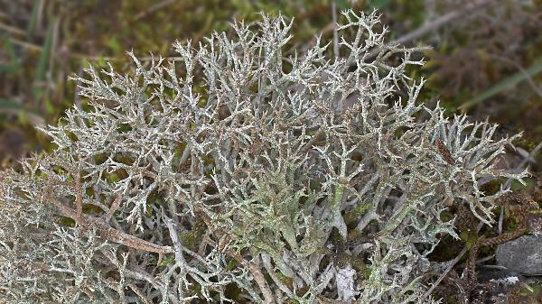
Domenico Puntillo - CC BY 4.0
Italy, Calabria, Bosco di Mavigliano, Montalto Uffugo
Wolfgang von Brackel - CC BY-4.0
Germany, Bavaria, Hochmutting
Wolfgang von Brackel - CC BY-4.0
Germany, Bavaria, Külsheim
Wolfgang von Brackel - CC BY-4.0
Germany, Bavaria, Oberviechtach
Wolfgang von Brackel - CC BY-4.0
Germany, Bavaria, Oberviechtach
Growth form: Fruticose
Substrata: soil, terricolous mosses, and plant debris
Photobiont: green algae other than Trentepohlia
Reproductive strategy: mainly sexual
Commonnes-rarity: (info)
Alpine belt: absent
Subalpine belt: extremely rare
Montane belt: common
Dry submediterranean belt: extremely common
Humid submediterranean belt: extremely common
Padanian area: very rare
pH of the substrata:
| 1 | 2 | 3 | 4 | 5 |
Solar irradiation:
| 1 | 2 | 3 | 4 | 5 |
Aridity:
| 1 | 2 | 3 | 4 | 5 |
Eutrophication:
| 1 | 2 | 3 | 4 | 5 |
Poleotolerance:
| 0 | 1 | 2 | 3 |
Altitudinal distribution:
| 1 | 2 | 3 | 4 | 5 | 6 |
Rarity
absent
extremely rare
very rare
rare
rather rare
rather common
common
very common
extremely common
Loading data...
Occurrence data
Predictive map
Current prediction (1981-2010)Future prediction (2071-2100) SSP 1-2.6Future prediction (2071-2100) SSP 5-8.5Predictive maps according to Francesconi et al. 2025

Gabriele Gheza - https://lichenidilombardia.home.blog
Italy, Toscana, Firenze, Fiesole, Monte Ceceri, 390 m
31/01/2020
P.L. Nimis; Owner: Department of Life Sciences, University of Trieste
Herbarium: TSB (33876)
2001/12/09
detail of branch with squamules
Simonetta Peruzzi; Owner: Simonetta Peruzzi
Italy, Toscana, Parco Nazionale delle Foreste Casentinesi
2010
Paolo Fontanesi; Owner: Paolo Fontanesi
Italy, Emilia-Romagna, Reggio Emilia, Riserva Naturale di Campotrera.
Herbarium: Forum Natura Mediterraneo
2010
Andrea Moro; Owner: Department of Life Sciences, University of Trieste
Italy, Friuli Venezia Giulia, Trieste, Trieste Karst. Loc. Slivia,near the Castelliere
11.2016

Felix Schumm – CC BY-SA 4.0
[9232], Spanien, Kanaren, La Gomera: Am Weg zum Garajonay vom Parkplatz Contadero-Mimbreras. Lorbeer-Erica Wald. 28°06.828' N, 17°14.624 W, 1440 m. Auf Erde an Wegböschung. Leg. Schumm 11.02.2002 det. Schumm 2007
Felix Schumm – CC BY-SA 4.0
[9232], Spanien, Kanaren, La Gomera: Am Weg zum Garajonay vom Parkplatz Contadero-Mimbreras. Lorbeer-Erica Wald. 28°06.828' N, 17°14.624 W, 1440 m. Auf Erde an Wegböschung. Leg. Schumm 11.02.2002 det. Schumm 2007

Felix Schumm – CC BY-SA 4.0
[9232], Spanien, Kanaren, La Gomera: Am Weg zum Garajonay vom Parkplatz Contadero-Mimbreras. Lorbeer-Erica Wald. 28°06.828' N, 17°14.624 W, 1440 m. Auf Erde an Wegböschung. Leg. Schumm 11.02.2002 det. Schumm 2007
Felix Schumm – CC BY-SA 4.0
[9232], Spanien, Kanaren, La Gomera: Am Weg zum Garajonay vom Parkplatz Contadero-Mimbreras. Lorbeer-Erica Wald. 28°06.828' N, 17°14.624 W, 1440 m. Auf Erde an Wegböschung. Leg. Schumm 11.02.2002 det. Schumm 2007

Felix Schumm – CC BY-SA 4.0
[9232], Spanien, Kanaren, La Gomera: Am Weg zum Garajonay vom Parkplatz Contadero-Mimbreras. Lorbeer-Erica Wald. 28°06.828' N, 17°14.624 W, 1440 m. Auf Erde an Wegböschung. Leg. Schumm 11.02.2002 det. Schumm 2007

Felix Schumm – CC BY-SA 4.0
[9232], Spanien, Kanaren, La Gomera: Am Weg zum Garajonay vom Parkplatz Contadero-Mimbreras. Lorbeer-Erica Wald. 28°06.828' N, 17°14.624 W, 1440 m. Auf Erde an Wegböschung. Leg. Schumm 11.02.2002 det. Schumm 2007

Felix Schumm – CC BY-SA 4.0
[9232], Spanien, Kanaren, La Gomera: Am Weg zum Garajonay vom Parkplatz Contadero-Mimbreras. Lorbeer-Erica Wald. 28°06.828' N, 17°14.624 W, 1440 m. Auf Erde an Wegböschung. Leg. Schumm 11.02.2002 det. Schumm 2007

Felix Schumm – CC BY-SA 4.0
[9232], Spanien, Kanaren, La Gomera: Am Weg zum Garajonay vom Parkplatz Contadero-Mimbreras. Lorbeer-Erica Wald. 28°06.828' N, 17°14.624 W, 1440 m. Auf Erde an Wegböschung. Leg. Schumm 11.02.2002 det. Schumm 2007

Felix Schumm – CC BY-SA 4.0
[16609], Germany, Baden-Württemberg, Alb-Donau-Kreis, zwischen Altheim und Gerstetten in Trockenrasen zwischen südexponierten Kalkfelsen im Hungerbrunnental, 48,59616° N, 10,03926° E, 545 m. Leg. et det. Schumm 25.08.2010.

Felix Schumm – CC BY-SA 4.0
[16609], Germany, Baden-Württemberg, Alb-Donau-Kreis, zwischen Altheim und Gerstetten in Trockenrasen zwischen südexponierten Kalkfelsen im Hungerbrunnental, 48,59616° N, 10,03926° E, 545 m. Leg. et det. Schumm 25.08.2010.
Felix Schumm – CC BY-SA 4.0
[16609], Germany, Baden-Württemberg, Alb-Donau-Kreis, zwischen Altheim und Gerstetten in Trockenrasen zwischen südexponierten Kalkfelsen im Hungerbrunnental, 48,59616° N, 10,03926° E, 545 m. Leg. et det. Schumm 25.08.2010.
Felix Schumm – CC BY-SA 4.0
[16609], Germany, Baden-Württemberg, Alb-Donau-Kreis, zwischen Altheim und Gerstetten in Trockenrasen zwischen südexponierten Kalkfelsen im Hungerbrunnental, 48,59616° N, 10,03926° E, 545 m. Leg. et det. Schumm 25.08.2010.

Felix Schumm – CC BY-SA 4.0
[16609], Germany, Baden-Württemberg, Alb-Donau-Kreis, zwischen Altheim und Gerstetten in Trockenrasen zwischen südexponierten Kalkfelsen im Hungerbrunnental, 48,59616° N, 10,03926° E, 545 m. Leg. et det. Schumm 25.08.2010.
Felix Schumm – CC BY-SA 4.0
[16609], Germany, Baden-Württemberg, Alb-Donau-Kreis, zwischen Altheim und Gerstetten in Trockenrasen zwischen südexponierten Kalkfelsen im Hungerbrunnental, 48,59616° N, 10,03926° E, 545 m. Leg. et det. Schumm 25.08.2010.
Felix Schumm – CC BY-SA 4.0
[16609], Germany, Baden-Württemberg, Alb-Donau-Kreis, zwischen Altheim und Gerstetten in Trockenrasen zwischen südexponierten Kalkfelsen im Hungerbrunnental, 48,59616° N, 10,03926° E, 545 m. Leg. et det. Schumm 25.08.2010.

Felix Schumm – CC BY-SA 4.0
[16609], Germany, Baden-Württemberg, Alb-Donau-Kreis, zwischen Altheim und Gerstetten in Trockenrasen zwischen südexponierten Kalkfelsen im Hungerbrunnental, 48,59616° N, 10,03926° E, 545 m. Leg. et det. Schumm 25.08.2010.

Felix Schumm – CC BY-SA 4.0
[16609], Germany, Baden-Württemberg, Alb-Donau-Kreis, zwischen Altheim und Gerstetten in Trockenrasen zwischen südexponierten Kalkfelsen im Hungerbrunnental, 48,59616° N, 10,03926° E, 545 m. Leg. et det. Schumm 25.08.2010.
Felix Schumm – CC BY-SA 4.0
[16609], Germany, Baden-Württemberg, Alb-Donau-Kreis, zwischen Altheim und Gerstetten in Trockenrasen zwischen südexponierten Kalkfelsen im Hungerbrunnental, 48,59616° N, 10,03926° E, 545 m. Leg. et det. Schumm 25.08.2010.
Felix Schumm – CC BY-SA 4.0
Image from: F. Schumm (2008) - Flechten Madeiras, der Kanaren und Azoren. Beck, OHG - ISBN: 978-3-00-023700-3
Felix Schumm – CC BY-SA 4.0
[19464], Germany, Hessen, Amöneburg bei Marburg, sonnige Basaltblöcke in einer Hangwiese kurz vor dem Ortseingang, 50.7896° N, 8.91995° E, 324 m. Leg. F. Schumm, 01.08.2016, det. F. Schumm.

A. Moro; Owner: Department of Life Sciences, University of Trieste
Sicilia, TP, Isola di Marettimo
2008.04.03

Felix Schumm – CC BY-SA 4.0
[12436], Griechenland, N-Samos, südlich von Agios Konstandinos, an der Straße nach Manolates, sonnige Terrassenmauern, 37°342'N, 26°49.527'E, 318 m. Leg. Schumm, Düll, Maier 05.05.2006.
Felix Schumm – CC BY-SA 4.0
[12436], Griechenland, N-Samos, südlich von Agios Konstandinos, an der Straße nach Manolates, sonnige Terrassenmauern, 37°342'N, 26°49.527'E, 318 m. Leg. Schumm, Düll, Maier 05.05.2006.

Gabriele Gheza - https://lichenidilombardia.home.blog
Italy, Piemonte, Novara, Trecate, valle del Ticino, 120 m
09/03/2021
primary thallus

Gabriele Gheza - https://lichenidilombardia.home.blog
Italy, Lombardia, Milano, Motta Visconti, valle del Ticino, 76 m
29/01/2021
Gabriele Gheza - https://lichenidilombardia.home.blog
Italy, Lombardia, Milano, Motta Visconti, valle del Ticino, 76 m
29/01/2021
Gabriele Gheza - https://lichenidilombardia.home.blog
Italy, Toscana, Firenze, Fiesole, Monte Ceceri, 390 m
31/01/2020

Felix Schumm – CC BY-SA 4.0
[19464], Germany, Hessen, Amöneburg bei Marburg, sonnige Basaltblöcke in einer Hangwiese kurz vor dem Ortseingang, 50.7896° N, 8.91995° E, 324 m. Leg. F. Schumm, 01.08.2016, det. F. Schumm.
Gabriele Gheza - https://lichenidilombardia.home.blog
Italy, Toscana, Firenze, Fiesole, Monte Ceceri, 390 m
31/01/2020

Gabriele Gheza - https://lichenidilombardia.home.blog
Italy, Toscana, Firenze, Fiesole, Monte Ceceri, 390 m
31/01/2020
Gabriele Gheza - https://lichenidilombardia.home.blog
Italy, Toscana, Firenze, Fiesole, Monte Ceceri, 390 m
31/01/2020

Gabriele Gheza - https://lichenidilombardia.home.blog
Italy, Piemonte, Novara, Oleggio, valle del Ticino, 163 m
10/2013
Gabriele Gheza - https://lichenidilombardia.home.blog
Italy, Piemonte, Novara, Oleggio, valle del Ticino, 163 m
10/2013
Manuel Gil
Spain, Canary Islands, Lanzarote
Bernard Bouffinier - Source: http://www.lichensmaritimes.org/index.php?task=fiche&lichen=227&lang=en
France, Crozon

Bernard Bouffinier - Source: http://www.lichensmaritimes.org/index.php?task=fiche&lichen=227&lang=en
France, Ty Lann

Bernard Bouffinier - Source: http://www.lichensmaritimes.org/index.php?task=fiche&lichen=227&lang=en
France, Ty Lann

Bernard Bouffinier - Source: http://www.lichensmaritimes.org/index.php?task=fiche&lichen=227&lang=en
France, Ty Lann
Bernard Bouffinier - Source: http://www.lichensmaritimes.org/index.php?task=fiche&lichen=227&lang=en
France, Primel
P+ rouge
Bernard Bouffinier - Source: http://www.lichensmaritimes.org/index.php?task=fiche&lichen=227&lang=en
France, Primel
P+ rouge

Bernard Bouffinier - Source: http://www.lichensmaritimes.org/index.php?task=fiche&lichen=227&lang=en
France, Primel
P+ rouge
Michel David - Source: http://www.lichensmaritimes.org/index.php?task=fiche&lichen=227&lang=en
France, La Palue
Michel David - Source: http://www.lichensmaritimes.org/index.php?task=fiche&lichen=227&lang=en
France, La Palue
Bernard Bouffinier - Source: http://www.lichensmaritimes.org/index.php?task=fiche&lichen=1335&lang=en
France, Sainte Anne la Palud
var. pungens

Bernard Bouffinier - Source: http://www.lichensmaritimes.org/index.php?task=fiche&lichen=1335&lang=en
France, Sainte Anne la Palud
var. pungens
Bernard Bouffinier - Source: http://www.lichensmaritimes.org/index.php?task=fiche&lichen=1335&lang=en
France, Sainte Anne la Palud
var. pungens
Bernard Bouffinier - Source: http://www.lichensmaritimes.org/index.php?task=fiche&lichen=1335&lang=en
France, Sainte Anne la Palud
var. pungens
Arnaud Delhoume - Source: http://www.lichensmaritimes.org/index.php?task=fiche&lichen=1335&lang=en
Croatia
var. pungens

Arnaud Delhoume - Source: http://www.lichensmaritimes.org/index.php?task=fiche&lichen=1335&lang=en
Croatia
var. pungens
Bernard Bouffinier - Source: http://www.lichensmaritimes.org/index.php?task=fiche&lichen=1335&lang=en
France, La Palue
var. pungens
Bernard Bouffinier - Source: http://www.lichensmaritimes.org/index.php?task=fiche&lichen=1335&lang=en
France, Manosque
var. pungens

Arnaud Delhoume - Source: http://www.lichensmaritimes.org/index.php?task=fiche&lichen=1335&lang=en
Croatia
var. pungens, sorediate form

Arnaud Delhoume - Source: http://www.lichensmaritimes.org/index.php?task=fiche&lichen=1335&lang=en
Croatia
var. pungens, sorediate form
Arnaud Delhoume - Source: http://www.lichensmaritimes.org/index.php?task=fiche&lichen=1335&lang=en
Croatia
var. pungens, sorediate form
Arnaud Delhoume - Source: http://www.lichensmaritimes.org/index.php?task=fiche&lichen=1335&lang=en
Croatia
var. pungens, sorediate form

Arnaud Delhoume - Source: http://www.lichensmaritimes.org/index.php?task=fiche&lichen=1335&lang=en
Croatia
var. pungens, sorediate form
Arnaud Delhoume - Source: http://www.lichensmaritimes.org/index.php?task=fiche&lichen=1335&lang=en
Croatia
var. pungens, sorediate form
Arnaud Delhoume - Source: http://www.lichensmaritimes.org/index.php?task=fiche&lichen=1335&lang=en
Croatia
var. pungens, sorediate form
Ulrich Kirschbaum CC BY-SA 4.0 - Source: https://www.thm.de/lse/ulrich-kirschbaum/flechtenbilder
Canary Islands; La Gomera-MN; s of Las Rosas; s of Roque Blanco: near Mirador Dinero.
Ulrich Kirschbaum CC BY-SA 4.0 - Source: https://www.thm.de/lse/ulrich-kirschbaum/flechtenbilder
Canary Islands; La Gomera-MN; s of Las Rosas; s of Roque Blanco: near Mirador Dinero.

Ulrich Kirschbaum CC BY-SA 4.0 - Source: https://www.thm.de/lse/ulrich-kirschbaum/flechtenbilder
Central Europe; Germany: Hesse.
with C. rangiferina (left)

Ulrich Kirschbaum CC BY-SA 4.0 - Source: https://www.thm.de/lse/ulrich-kirschbaum/flechtenbilder
Central Europe; Germany: Hesse.
with C. rangiferina (left)

Ulrich Kirschbaum CC BY-SA 4.0 - Source: https://www.thm.de/lse/ulrich-kirschbaum/flechtenbilder
SE Europe; N-Cyprus; E of Girne; Beşparmak Mountains; between Kantara Village and Kantara Castle

Ulrich Kirschbaum CC BY-SA 4.0 - Source: https://www.thm.de/lse/ulrich-kirschbaum/flechtenbilder
SE Europe; N-Cyprus; E of Girne; Beşparmak Mountains; between Kantara Village and Kantara Castle

Domenico Puntillo - CC BY 4.0
Italy, Calabria, Bosco di Mavigliano, Montalto Uffugo

Wolfgang von Brackel - CC BY-4.0
Germany, Bavaria, Hochmutting

Wolfgang von Brackel - CC BY-4.0
Germany, Bavaria, Külsheim

Wolfgang von Brackel - CC BY-4.0
Germany, Bavaria, Oberviechtach


