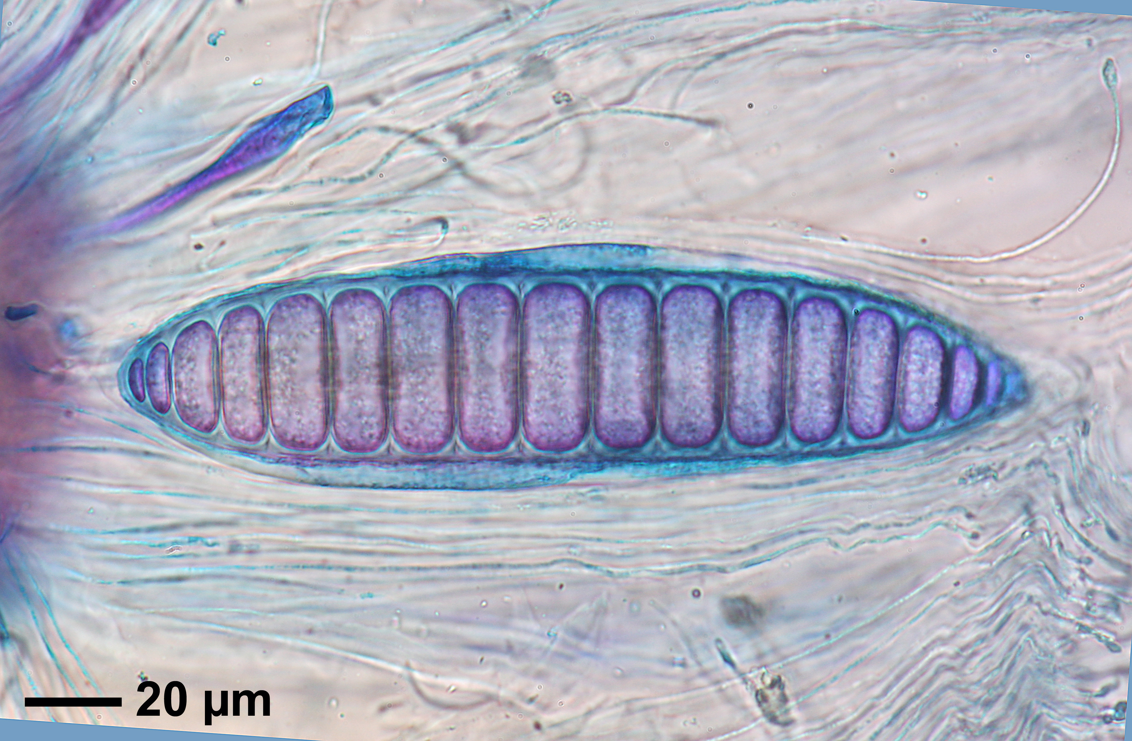
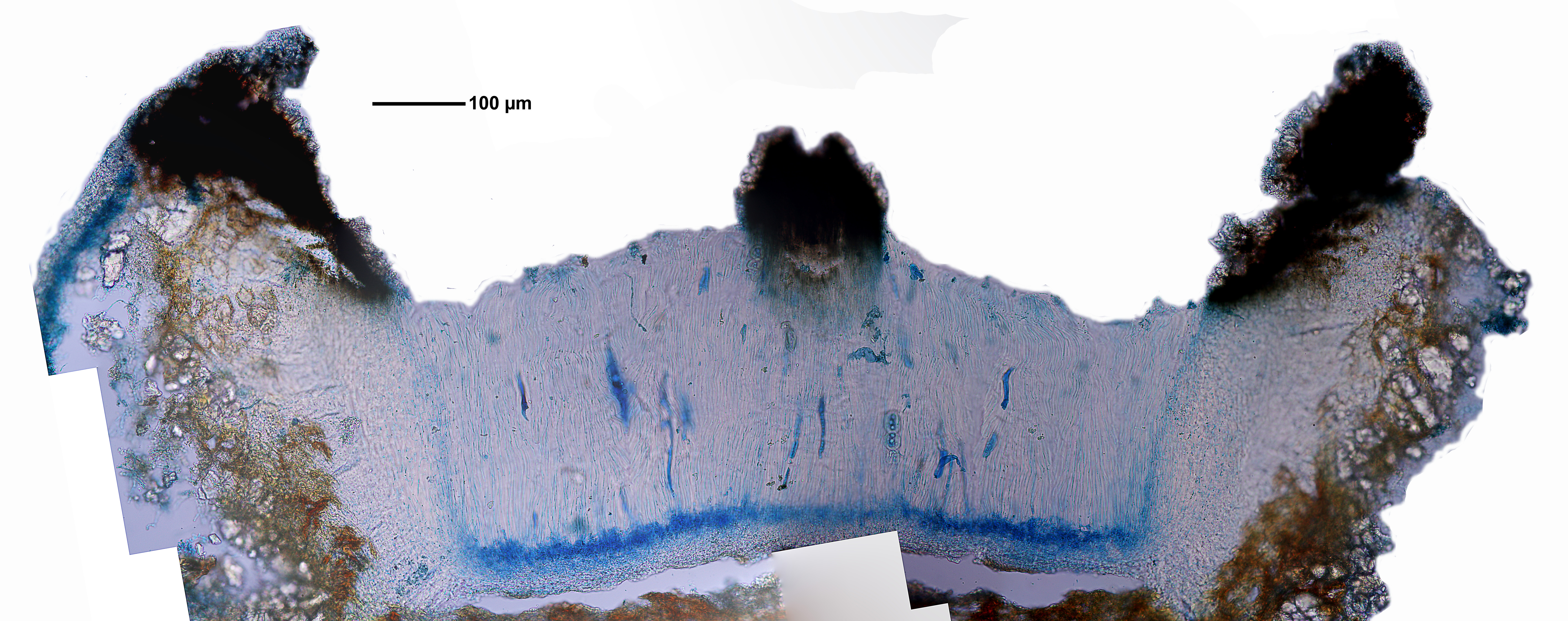
[7771], Philippinen, Leyte, Prov. Leyte, Weg vom Gipfel des Mt. Agipo (10°46.729’ N, 124°49.781’ E, 885 m) nach Kadwa-An (10°46.249’ N, E 124°48.167’ E, 195 m), bei 750 m. Leg. Schumm 18.08.2000, det. Schumm, test Sipman 2012.
Felix Schumm – CC BY-SA 4.0
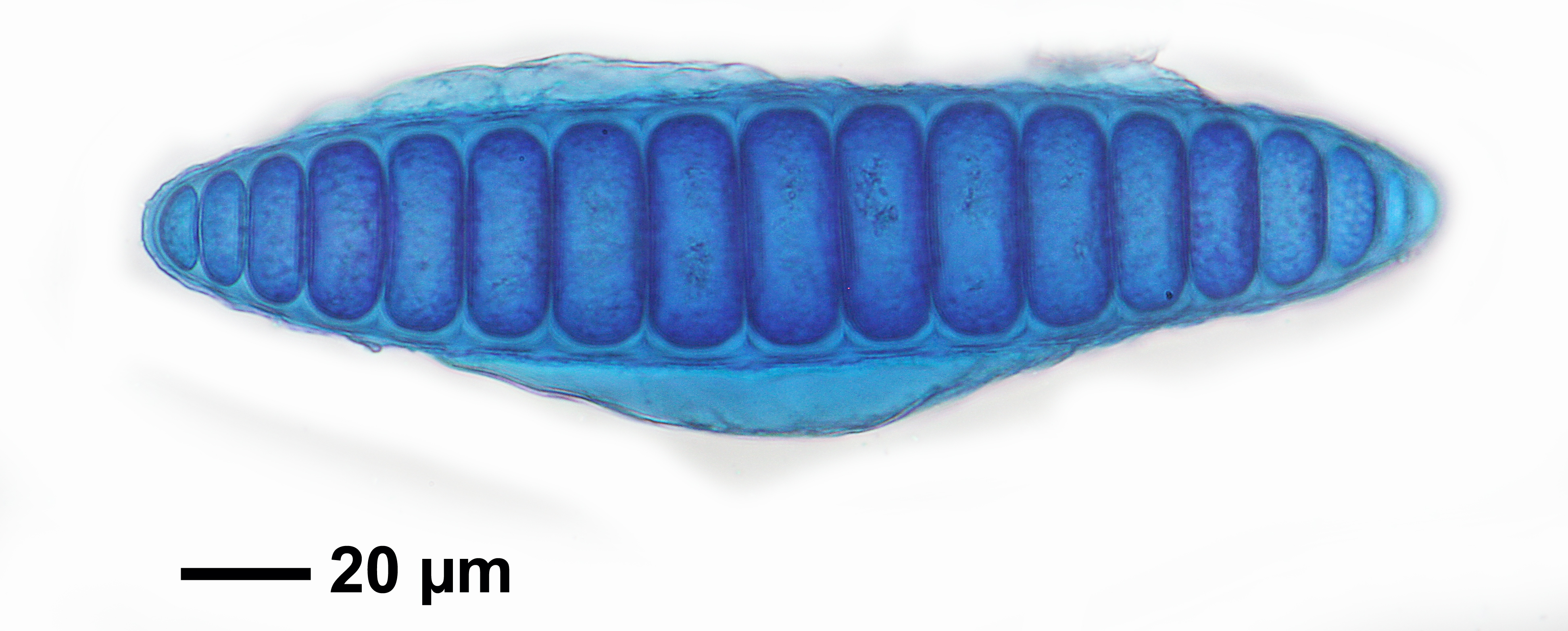
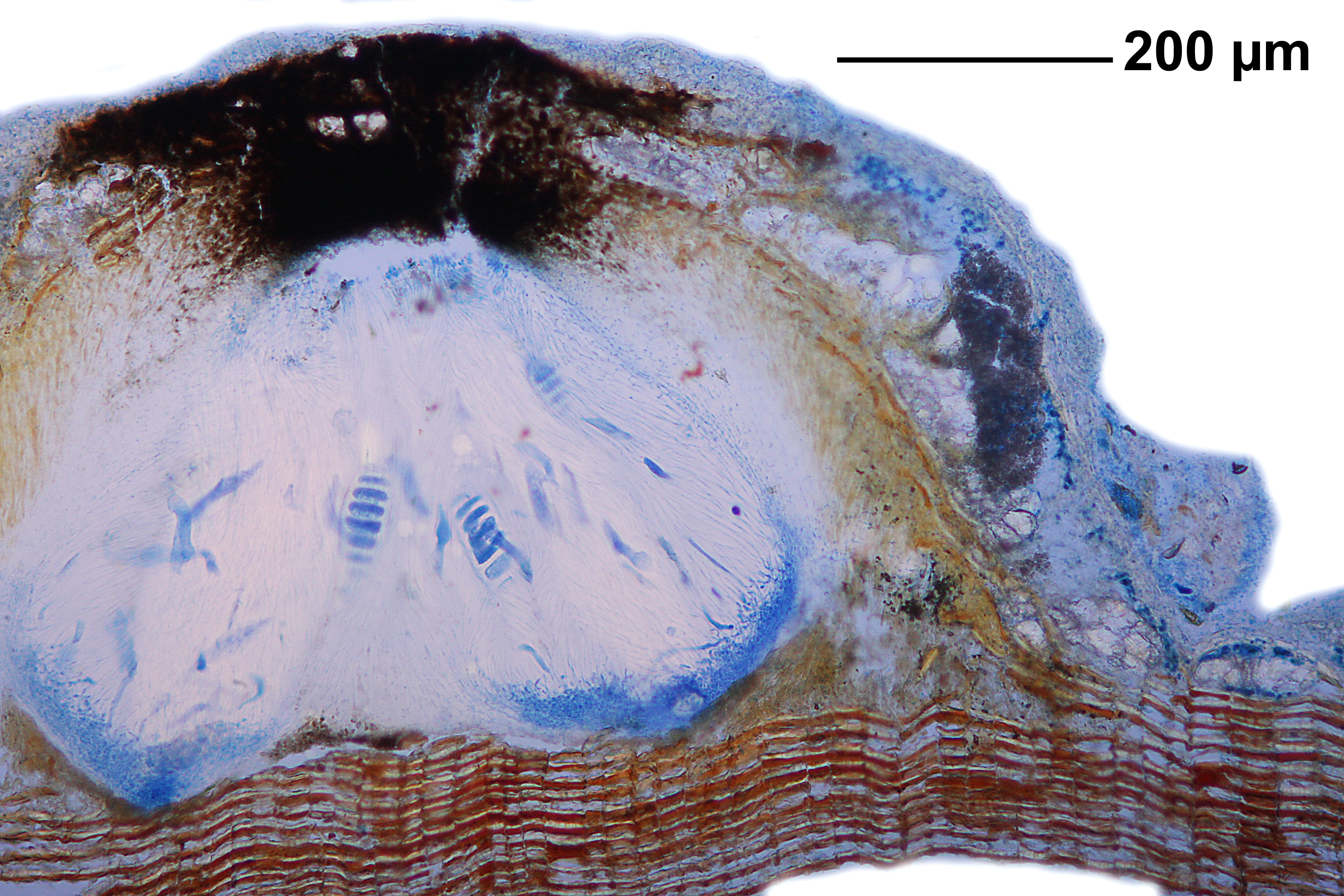
[7598], Philippinen, Negros, Prov. Negros Oriental, Mt. Talinis (Cuernos de Negros), Lunga Nature Trail beim Lake Yagumyum, 9°15.040’ N, 123°11.172’ E, 1360 m. Leg. Schumm 11.08.2000., det. Schumm 2012, test. Sipman 2012.
Felix Schumm – CC BY-SA 4.0
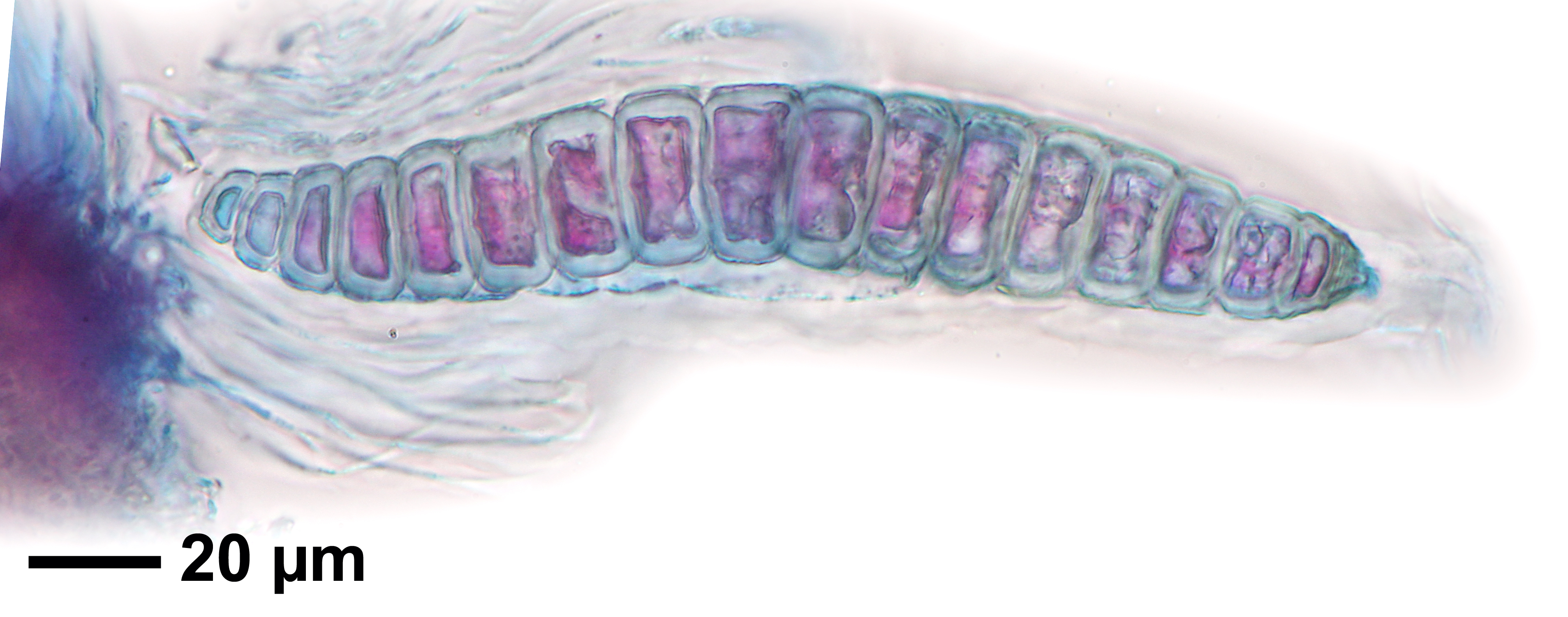
[7598], Philippinen, Negros, Prov. Negros Oriental, Mt. Talinis (Cuernos de Negros), Lunga Nature Trail beim Lake Yagumyum, 9°15.040’ N, 123°11.172’ E, 1360 m. Leg. Schumm 11.08.2000., det. Schumm 2012, test. Sipman 2012.
Felix Schumm – CC BY-SA 4.0
[7598], Philippinen, Negros, Prov. Negros Oriental, Mt. Talinis (Cuernos de Negros), Lunga Nature Trail beim Lake Yagumyum, 9°15.040’ N, 123°11.172’ E, 1360 m. Leg. Schumm 11.08.2000., det. Schumm 2012, test. Sipman 2012.
Felix Schumm – CC BY-SA 4.0
[7598], Philippinen, Negros, Prov. Negros Oriental, Mt. Talinis (Cuernos de Negros), Lunga Nature Trail beim Lake Yagumyum, 9°15.040’ N, 123°11.172’ E, 1360 m. Leg. Schumm 11.08.2000., det. Schumm 2012, test. Sipman 2012.
Felix Schumm – CC BY-SA 4.0
[7598], Philippinen, Negros, Prov. Negros Oriental, Mt. Talinis (Cuernos de Negros), Lunga Nature Trail beim Lake Yagumyum, 9°15.040’ N, 123°11.172’ E, 1360 m. Leg. Schumm 11.08.2000., det. Schumm 2012, test. Sipman 2012.
Felix Schumm – CC BY-SA 4.0
[7598], Philippinen, Negros, Prov. Negros Oriental, Mt. Talinis (Cuernos de Negros), Lunga Nature Trail beim Lake Yagumyum, 9°15.040’ N, 123°11.172’ E, 1360 m. Leg. Schumm 11.08.2000., det. Schumm 2012, test. Sipman 2012.
Felix Schumm – CC BY-SA 4.0
[7598], Philippinen, Negros, Prov. Negros Oriental, Mt. Talinis (Cuernos de Negros), Lunga Nature Trail beim Lake Yagumyum, 9°15.040’ N, 123°11.172’ E, 1360 m. Leg. Schumm 11.08.2000., det. Schumm 2012, test. Sipman 2012.
Felix Schumm – CC BY-SA 4.0
[7598], Philippinen, Negros, Prov. Negros Oriental, Mt. Talinis (Cuernos de Negros), Lunga Nature Trail beim Lake Yagumyum, 9°15.040’ N, 123°11.172’ E, 1360 m. Leg. Schumm 11.08.2000., det. Schumm 2012, test. Sipman 2012.
Felix Schumm – CC BY-SA 4.0
[7598], Philippinen, Negros, Prov. Negros Oriental, Mt. Talinis (Cuernos de Negros), Lunga Nature Trail beim Lake Yagumyum, 9°15.040’ N, 123°11.172’ E, 1360 m. Leg. Schumm 11.08.2000., det. Schumm 2012, test. Sipman 2012.
Felix Schumm – CC BY-SA 4.0
[7598], Philippinen, Negros, Prov. Negros Oriental, Mt. Talinis (Cuernos de Negros), Lunga Nature Trail beim Lake Yagumyum, 9°15.040’ N, 123°11.172’ E, 1360 m. Leg. Schumm 11.08.2000., det. Schumm 2012, test. Sipman 2012.
Felix Schumm – CC BY-SA 4.0
[7598], Philippinen, Negros, Prov. Negros Oriental, Mt. Talinis (Cuernos de Negros), Lunga Nature Trail beim Lake Yagumyum, 9°15.040’ N, 123°11.172’ E, 1360 m. Leg. Schumm 11.08.2000., det. Schumm 2012, test. Sipman 2012.
Felix Schumm – CC BY-SA 4.0
[7598], Philippinen, Negros, Prov. Negros Oriental, Mt. Talinis (Cuernos de Negros), Lunga Nature Trail beim Lake Yagumyum, 9°15.040’ N, 123°11.172’ E, 1360 m. Leg. Schumm 11.08.2000., det. Schumm 2012, test. Sipman 2012.
Felix Schumm – CC BY-SA 4.0
[7598], Philippinen, Negros, Prov. Negros Oriental, Mt. Talinis (Cuernos de Negros), Lunga Nature Trail beim Lake Yagumyum, 9°15.040’ N, 123°11.172’ E, 1360 m. Leg. Schumm 11.08.2000., det. Schumm 2012, test. Sipman 2012.
Felix Schumm – CC BY-SA 4.0
[7598], Philippinen, Negros, Prov. Negros Oriental, Mt. Talinis (Cuernos de Negros), Lunga Nature Trail beim Lake Yagumyum, 9°15.040’ N, 123°11.172’ E, 1360 m. Leg. Schumm 11.08.2000., det. Schumm 2012, test. Sipman 2012.
Felix Schumm – CC BY-SA 4.0
[7598], Philippinen, Negros, Prov. Negros Oriental, Mt. Talinis (Cuernos de Negros), Lunga Nature Trail beim Lake Yagumyum, 9°15.040’ N, 123°11.172’ E, 1360 m. Leg. Schumm 11.08.2000., det. Schumm 2012, test. Sipman 2012.
Felix Schumm – CC BY-SA 4.0
[7598], Philippinen, Negros, Prov. Negros Oriental, Mt. Talinis (Cuernos de Negros), Lunga Nature Trail beim Lake Yagumyum, 9°15.040’ N, 123°11.172’ E, 1360 m. Leg. Schumm 11.08.2000., det. Schumm 2012, test. Sipman 2012.
Felix Schumm – CC BY-SA 4.0
[7598], Philippinen, Negros, Prov. Negros Oriental, Mt. Talinis (Cuernos de Negros), Lunga Nature Trail beim Lake Yagumyum, 9°15.040’ N, 123°11.172’ E, 1360 m. Leg. Schumm 11.08.2000., det. Schumm 2012, test. Sipman 2012.
Felix Schumm – CC BY-SA 4.0
[7598], Philippinen, Negros, Prov. Negros Oriental, Mt. Talinis (Cuernos de Negros), Lunga Nature Trail beim Lake Yagumyum, 9°15.040’ N, 123°11.172’ E, 1360 m. Leg. Schumm 11.08.2000., det. Schumm 2012, test. Sipman 2012.
Felix Schumm – CC BY-SA 4.0
[7598], Philippinen, Negros, Prov. Negros Oriental, Mt. Talinis (Cuernos de Negros), Lunga Nature Trail beim Lake Yagumyum, 9°15.040’ N, 123°11.172’ E, 1360 m. Leg. Schumm 11.08.2000., det. Schumm 2012, test. Sipman 2012.
Felix Schumm – CC BY-SA 4.0
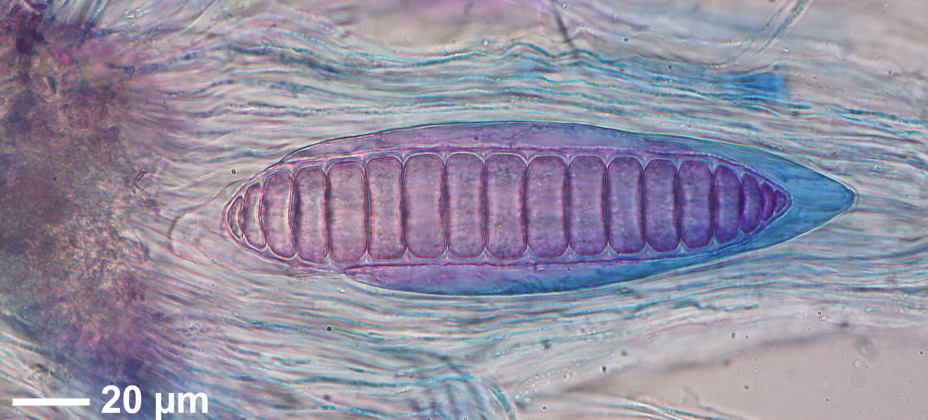
[7771], Philippinen, Leyte, Prov. Leyte, Weg vom Gipfel des Mt. Agipo (10°46.729’ N, 124°49.781’ E, 885 m) nach Kadwa-An (10°46.249’ N, E 124°48.167’ E, 195 m), bei 750 m. Leg. Schumm 18.08.2000, det. Schumm, test Sipman 2012.
Felix Schumm – CC BY-SA 4.0
[7771], Philippinen, Leyte, Prov. Leyte, Weg vom Gipfel des Mt. Agipo (10°46.729’ N, 124°49.781’ E, 885 m) nach Kadwa-An (10°46.249’ N, E 124°48.167’ E, 195 m), bei 750 m. Leg. Schumm 18.08.2000, det. Schumm, test Sipman 2012.
Felix Schumm – CC BY-SA 4.0
[7771], Philippinen, Leyte, Prov. Leyte, Weg vom Gipfel des Mt. Agipo (10°46.729’ N, 124°49.781’ E, 885 m) nach Kadwa-An (10°46.249’ N, E 124°48.167’ E, 195 m), bei 750 m. Leg. Schumm 18.08.2000, det. Schumm, test Sipman 2012.
Felix Schumm – CC BY-SA 4.0
[7771], Philippinen, Leyte, Prov. Leyte, Weg vom Gipfel des Mt. Agipo (10°46.729’ N, 124°49.781’ E, 885 m) nach Kadwa-An (10°46.249’ N, E 124°48.167’ E, 195 m), bei 750 m. Leg. Schumm 18.08.2000, det. Schumm, test Sipman 2012.
Felix Schumm – CC BY-SA 4.0
[7771], Philippinen, Leyte, Prov. Leyte, Weg vom Gipfel des Mt. Agipo (10°46.729’ N, 124°49.781’ E, 885 m) nach Kadwa-An (10°46.249’ N, E 124°48.167’ E, 195 m), bei 750 m. Leg. Schumm 18.08.2000, det. Schumm, test Sipman 2012.
Felix Schumm – CC BY-SA 4.0
[7771], Philippinen, Leyte, Prov. Leyte, Weg vom Gipfel des Mt. Agipo (10°46.729’ N, 124°49.781’ E, 885 m) nach Kadwa-An (10°46.249’ N, E 124°48.167’ E, 195 m), bei 750 m. Leg. Schumm 18.08.2000, det. Schumm, test Sipman 2012.
Felix Schumm – CC BY-SA 4.0
[7771], Philippinen, Leyte, Prov. Leyte, Weg vom Gipfel des Mt. Agipo (10°46.729’ N, 124°49.781’ E, 885 m) nach Kadwa-An (10°46.249’ N, E 124°48.167’ E, 195 m), bei 750 m. Leg. Schumm 18.08.2000, det. Schumm, test Sipman 2012.
Felix Schumm – CC BY-SA 4.0
[7771], Philippinen, Leyte, Prov. Leyte, Weg vom Gipfel des Mt. Agipo (10°46.729’ N, 124°49.781’ E, 885 m) nach Kadwa-An (10°46.249’ N, E 124°48.167’ E, 195 m), bei 750 m. Leg. Schumm 18.08.2000, det. Schumm, test Sipman 2012.
Felix Schumm – CC BY-SA 4.0
[7771], Philippinen, Leyte, Prov. Leyte, Weg vom Gipfel des Mt. Agipo (10°46.729’ N, 124°49.781’ E, 885 m) nach Kadwa-An (10°46.249’ N, E 124°48.167’ E, 195 m), bei 750 m. Leg. Schumm 18.08.2000, det. Schumm, test Sipman 2012.
Felix Schumm – CC BY-SA 4.0
[7771], Philippinen, Leyte, Prov. Leyte, Weg vom Gipfel des Mt. Agipo (10°46.729’ N, 124°49.781’ E, 885 m) nach Kadwa-An (10°46.249’ N, E 124°48.167’ E, 195 m), bei 750 m. Leg. Schumm 18.08.2000, det. Schumm, test Sipman 2012.
Felix Schumm – CC BY-SA 4.0
[7771], Philippinen, Leyte, Prov. Leyte, Weg vom Gipfel des Mt. Agipo (10°46.729’ N, 124°49.781’ E, 885 m) nach Kadwa-An (10°46.249’ N, E 124°48.167’ E, 195 m), bei 750 m. Leg. Schumm 18.08.2000, det. Schumm, test Sipman 2012.
Felix Schumm – CC BY-SA 4.0
[7771], Philippinen, Leyte, Prov. Leyte, Weg vom Gipfel des Mt. Agipo (10°46.729’ N, 124°49.781’ E, 885 m) nach Kadwa-An (10°46.249’ N, E 124°48.167’ E, 195 m), bei 750 m. Leg. Schumm 18.08.2000, det. Schumm, test Sipman 2012.
Felix Schumm – CC BY-SA 4.0
[7771], Philippinen, Leyte, Prov. Leyte, Weg vom Gipfel des Mt. Agipo (10°46.729’ N, 124°49.781’ E, 885 m) nach Kadwa-An (10°46.249’ N, E 124°48.167’ E, 195 m), bei 750 m. Leg. Schumm 18.08.2000, det. Schumm, test Sipman 2012.